

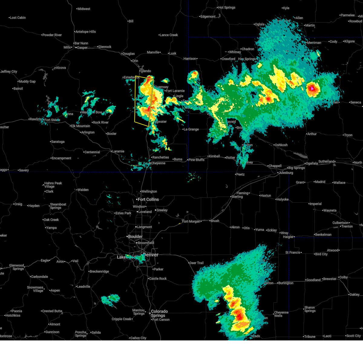
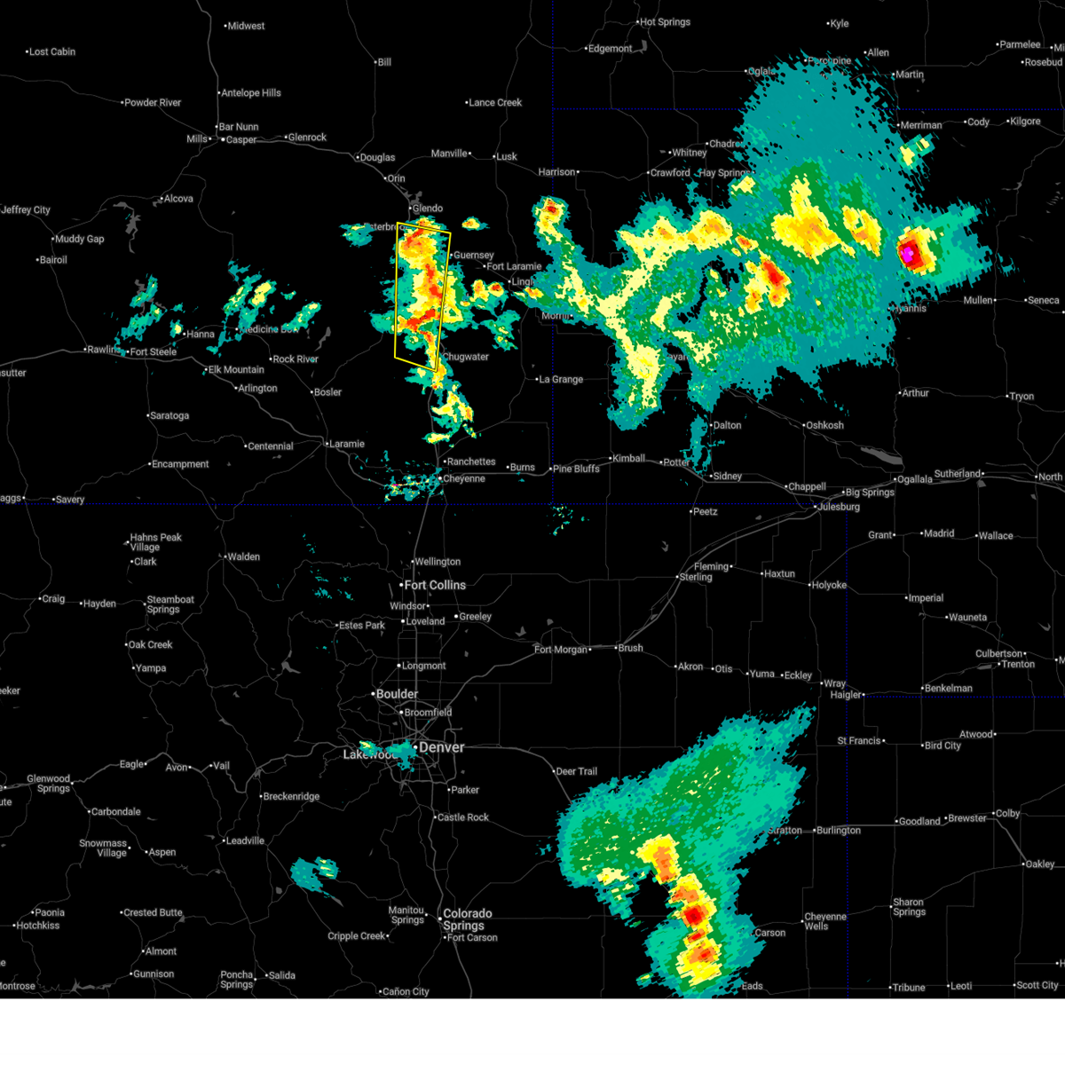
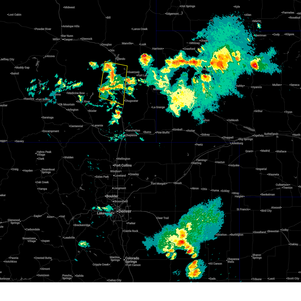
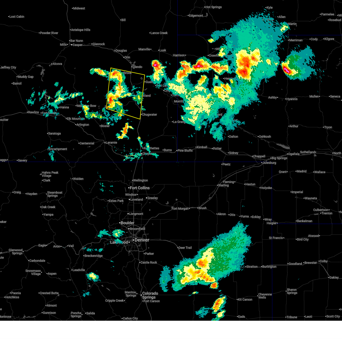
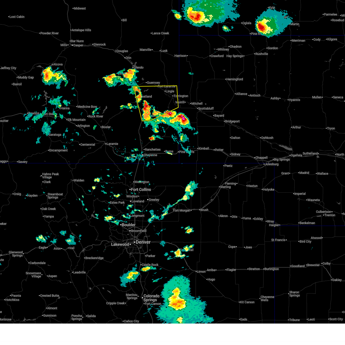
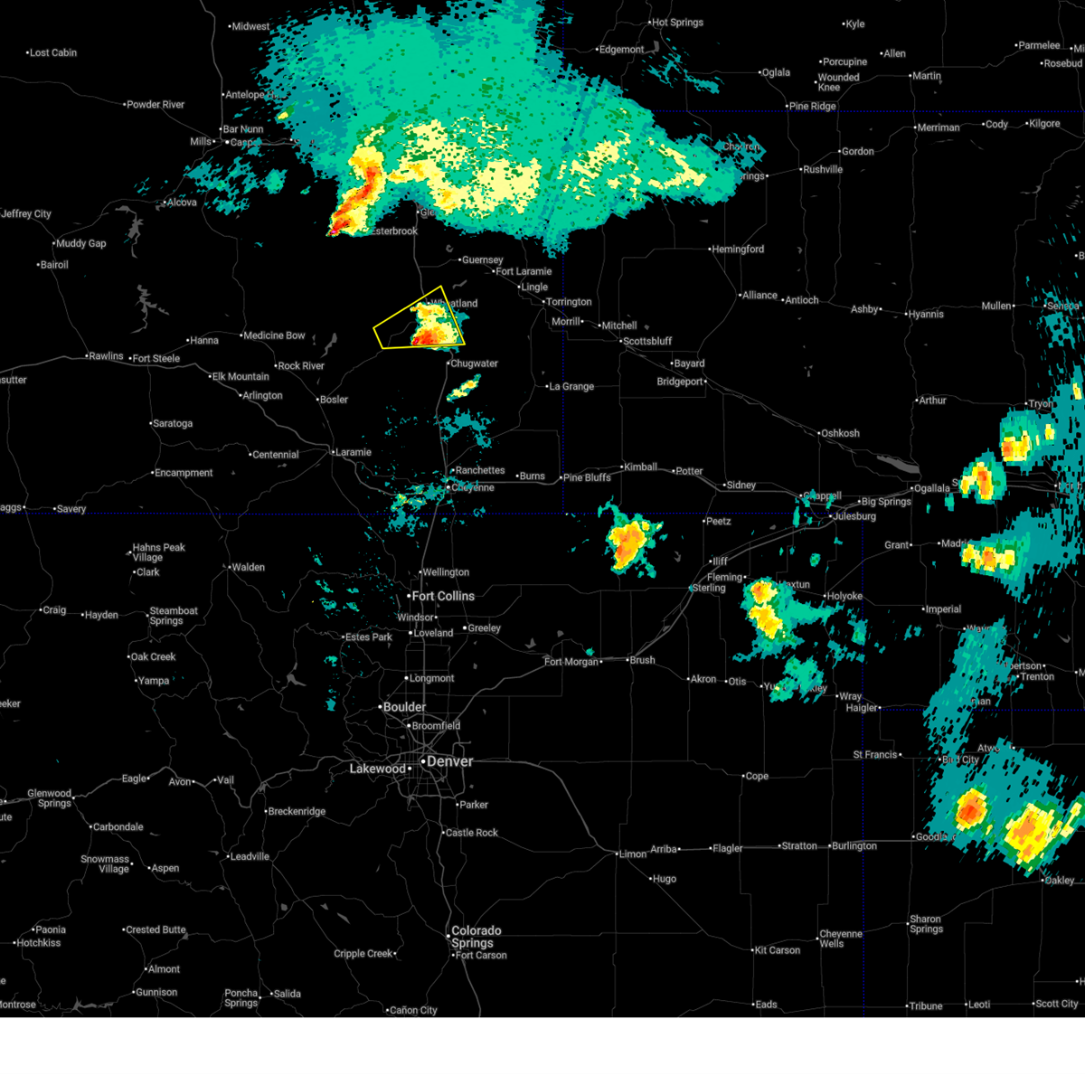
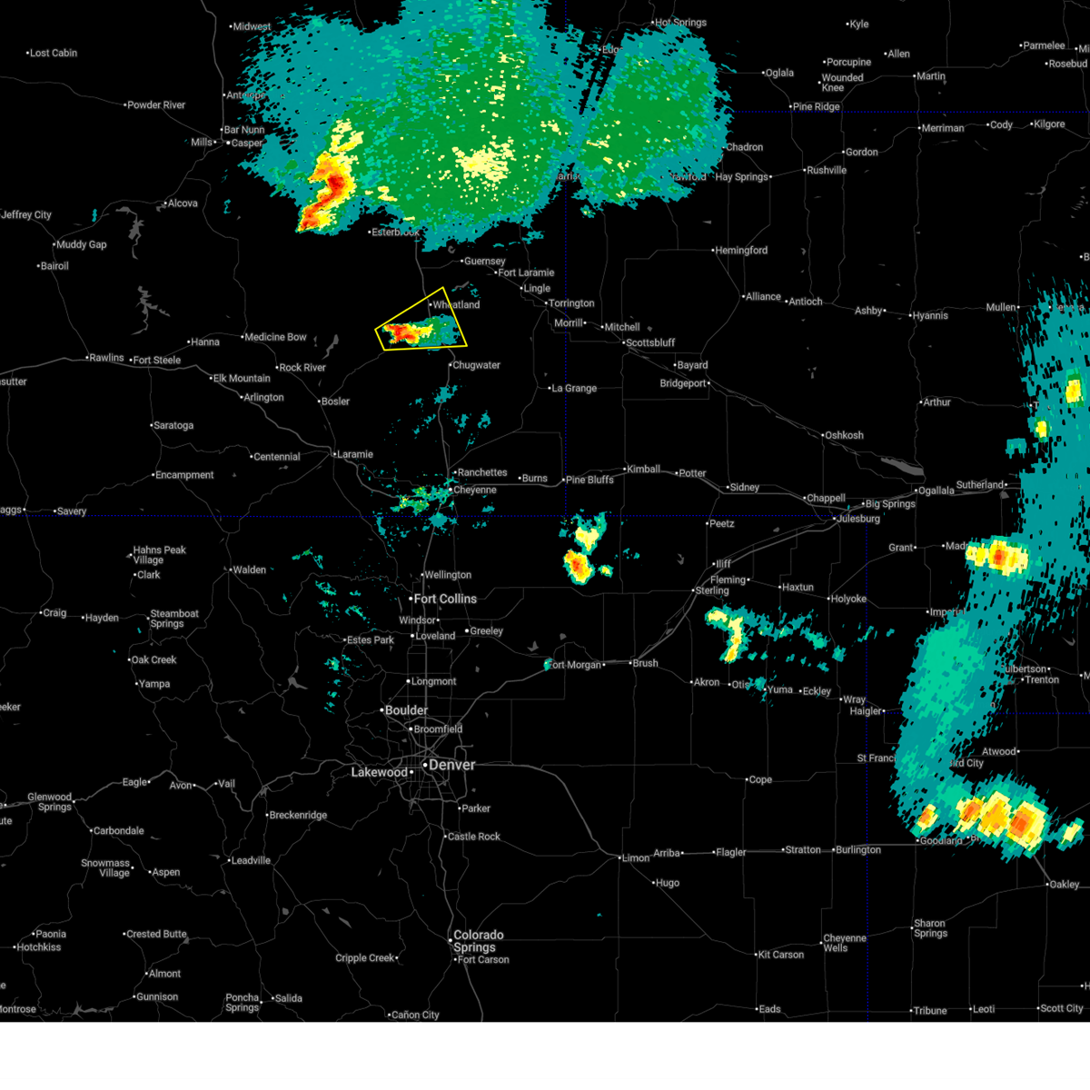
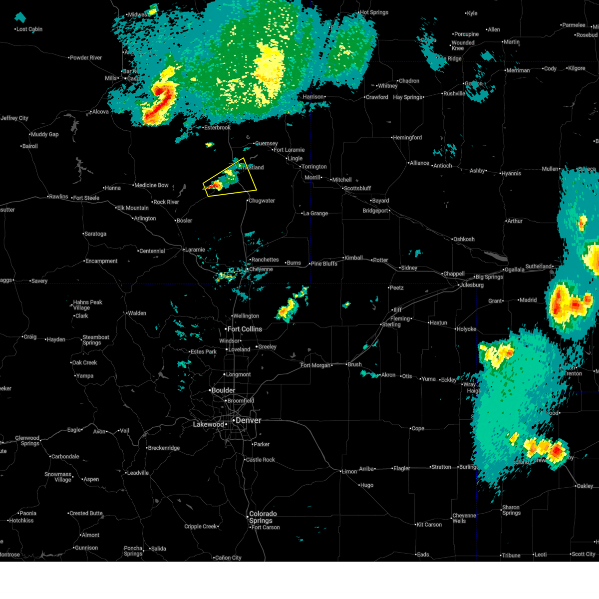
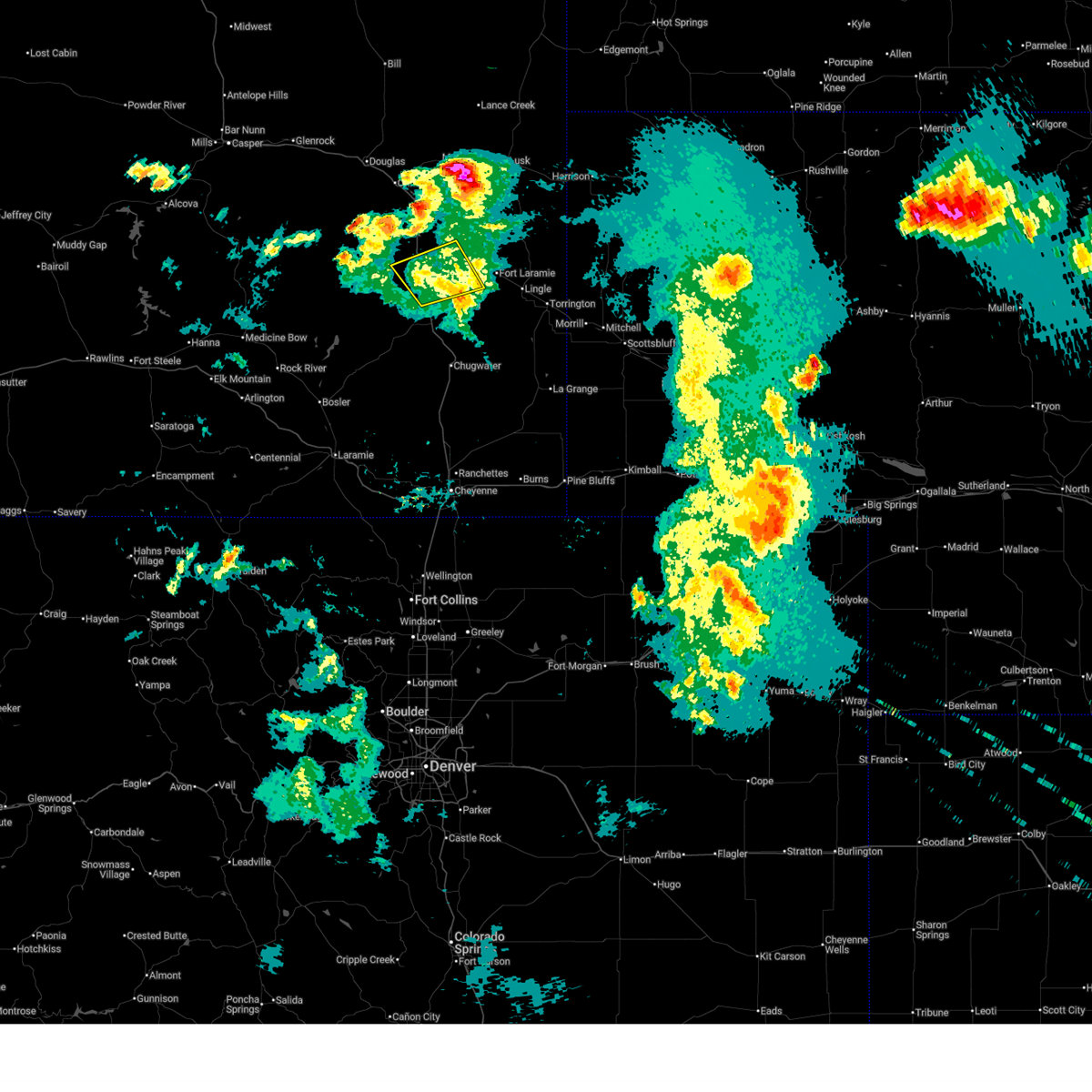
Hail Map for Wheatland, WY
The Wheatland, WY area has had 96 reports of on-the-ground hail by trained spotters, and has been under severe weather warnings 28 times during the past 12 months. Doppler radar has detected hail at or near Wheatland, WY on 54 occasions, including 6 occasions during the past year.
| Name: | Wheatland, WY |
| Where Located: | 61 miles NNE of Laramie, WY |
| Map: | Google Map for Wheatland, WY |
| Population: | 3627 |
| Housing Units: | 1879 |
| More Info: | Search Google for Wheatland, WY |
2
The Top Recent Hail Date for Wheatland, WY is Sunday, September 15, 2024 (8th out of 54)

Hail and Wind Damage Spotted near Wheatland, WY
| Date / Time | Report Details |
|---|---|
| 6/29/2025 8:31 PM MDT |
 The storms which prompted the warning have weakened below severe limits, and have exited the warned area. therefore, the warning has been allowed to expire. however, small hail, gusty winds and heavy rain are still possible with these thunderstorms. a severe thunderstorm watch remains in effect until 900 pm mdt for southeastern wyoming. The storms which prompted the warning have weakened below severe limits, and have exited the warned area. therefore, the warning has been allowed to expire. however, small hail, gusty winds and heavy rain are still possible with these thunderstorms. a severe thunderstorm watch remains in effect until 900 pm mdt for southeastern wyoming.
|
| 6/29/2025 8:15 PM MDT |
 the severe thunderstorm warning has been cancelled and is no longer in effect the severe thunderstorm warning has been cancelled and is no longer in effect
|
| 6/29/2025 8:15 PM MDT |
 At 815 pm mdt, severe thunderstorms were located along a line extending from 6 miles north of dwyer junction to 6 miles northwest of chugwater, moving east at 30 mph (radar indicated). Hazards include 60 mph wind gusts and penny size hail. Expect damage to roofs, siding, and trees. Locations impacted include, wheatland, chugwater, chugcreek, lakeview north, bordeaux, westview circle, y-o ranch, sandy cove campground, guernsey state park, phifer airfield, dwyer junction, slater, grayrocks reservoir, platte county fairgrounds, and antelope gap. At 815 pm mdt, severe thunderstorms were located along a line extending from 6 miles north of dwyer junction to 6 miles northwest of chugwater, moving east at 30 mph (radar indicated). Hazards include 60 mph wind gusts and penny size hail. Expect damage to roofs, siding, and trees. Locations impacted include, wheatland, chugwater, chugcreek, lakeview north, bordeaux, westview circle, y-o ranch, sandy cove campground, guernsey state park, phifer airfield, dwyer junction, slater, grayrocks reservoir, platte county fairgrounds, and antelope gap.
|
| 6/29/2025 7:57 PM MDT |
 At 757 pm mdt, severe thunderstorms were located along a line extending from 7 miles east of esterbrook campground to 9 miles east of sybille canyon, moving east at 40 mph (radar indicated). Hazards include 60 mph wind gusts and quarter size hail. Hail damage to vehicles is expected. expect wind damage to roofs, siding, and trees. Locations impacted include, wheatland, chugwater, chugcreek, lakeview north, bordeaux, westview circle, y-o ranch, sandy cove campground, guernsey state park, phifer airfield, dwyer junction, flying x ranch, harris park, slater, grayrocks reservoir, platte county fairgrounds, and antelope gap. At 757 pm mdt, severe thunderstorms were located along a line extending from 7 miles east of esterbrook campground to 9 miles east of sybille canyon, moving east at 40 mph (radar indicated). Hazards include 60 mph wind gusts and quarter size hail. Hail damage to vehicles is expected. expect wind damage to roofs, siding, and trees. Locations impacted include, wheatland, chugwater, chugcreek, lakeview north, bordeaux, westview circle, y-o ranch, sandy cove campground, guernsey state park, phifer airfield, dwyer junction, flying x ranch, harris park, slater, grayrocks reservoir, platte county fairgrounds, and antelope gap.
|
| 6/29/2025 7:41 PM MDT |
 Svrcys the national weather service in cheyenne has issued a * severe thunderstorm warning for, northeastern albany county in southeastern wyoming, central platte county in southeastern wyoming, south central converse county in east central wyoming, * until 830 pm mdt. * at 741 pm mdt, severe thunderstorms were located along a line extending from esterbrook campground to near flying x ranch, moving southeast at 35 mph (radar indicated). Hazards include 60 mph wind gusts and quarter size hail. Hail damage to vehicles is expected. Expect wind damage to roofs, siding, and trees. Svrcys the national weather service in cheyenne has issued a * severe thunderstorm warning for, northeastern albany county in southeastern wyoming, central platte county in southeastern wyoming, south central converse county in east central wyoming, * until 830 pm mdt. * at 741 pm mdt, severe thunderstorms were located along a line extending from esterbrook campground to near flying x ranch, moving southeast at 35 mph (radar indicated). Hazards include 60 mph wind gusts and quarter size hail. Hail damage to vehicles is expected. Expect wind damage to roofs, siding, and trees.
|
| 6/29/2025 5:36 PM MDT |
 Svrcys the national weather service in cheyenne has issued a * severe thunderstorm warning for, central goshen county in southeastern wyoming, southeastern platte county in southeastern wyoming, * until 630 pm mdt. * at 536 pm mdt, a severe thunderstorm was located near slater, or 17 miles southeast of wheatland, moving east at 30 mph (radar indicated). Hazards include 60 mph wind gusts and half dollar size hail. Hail damage to vehicles is expected. Expect wind damage to roofs, siding, and trees. Svrcys the national weather service in cheyenne has issued a * severe thunderstorm warning for, central goshen county in southeastern wyoming, southeastern platte county in southeastern wyoming, * until 630 pm mdt. * at 536 pm mdt, a severe thunderstorm was located near slater, or 17 miles southeast of wheatland, moving east at 30 mph (radar indicated). Hazards include 60 mph wind gusts and half dollar size hail. Hail damage to vehicles is expected. Expect wind damage to roofs, siding, and trees.
|
| 6/28/2025 8:08 PM MDT | Wy1. coleman wydo in platte county WY, 18.8 miles SSE of Wheatland, WY |
| 6/16/2025 10:31 PM MDT |
 The storm which prompted the warning has moved out of the area. therefore, the warning has been allowed to expire. however, hail is still possible with this thunderstorm. a severe thunderstorm warning has been re-issued for the area. The storm which prompted the warning has moved out of the area. therefore, the warning has been allowed to expire. however, hail is still possible with this thunderstorm. a severe thunderstorm warning has been re-issued for the area.
|
| 6/16/2025 10:06 PM MDT |
 At 1005 pm mdt, a severe thunderstorm was located over bordeaux, or 7 miles south of wheatland, moving east at 40 mph (radar indicated). Hazards include 60 mph wind gusts and quarter size hail. Hail damage to vehicles is expected. expect wind damage to roofs, siding, and trees. Locations impacted include, wheatland, phifer airfield, chugcreek, lakeview north, bordeaux, y-o ranch, slater, westview circle, platte county fairgrounds, and antelope gap. At 1005 pm mdt, a severe thunderstorm was located over bordeaux, or 7 miles south of wheatland, moving east at 40 mph (radar indicated). Hazards include 60 mph wind gusts and quarter size hail. Hail damage to vehicles is expected. expect wind damage to roofs, siding, and trees. Locations impacted include, wheatland, phifer airfield, chugcreek, lakeview north, bordeaux, y-o ranch, slater, westview circle, platte county fairgrounds, and antelope gap.
|
| 6/16/2025 9:48 PM MDT |
 Svrcys the national weather service in cheyenne has issued a * severe thunderstorm warning for, northeastern albany county in southeastern wyoming, southern platte county in southeastern wyoming, * until 1030 pm mdt. * at 947 pm mdt, a severe thunderstorm was located 7 miles east of flying x ranch, or 17 miles southwest of wheatland, moving east at 40 mph (radar indicated). Hazards include 60 mph wind gusts and half dollar size hail. Hail damage to vehicles is expected. Expect wind damage to roofs, siding, and trees. Svrcys the national weather service in cheyenne has issued a * severe thunderstorm warning for, northeastern albany county in southeastern wyoming, southern platte county in southeastern wyoming, * until 1030 pm mdt. * at 947 pm mdt, a severe thunderstorm was located 7 miles east of flying x ranch, or 17 miles southwest of wheatland, moving east at 40 mph (radar indicated). Hazards include 60 mph wind gusts and half dollar size hail. Hail damage to vehicles is expected. Expect wind damage to roofs, siding, and trees.
|
| 6/12/2025 7:06 PM MDT |
 The storm which prompted the warning has weakened below severe limits, and no longer poses an immediate threat to life or property. therefore, the warning will be allowed to expire. a severe thunderstorm watch remains in effect until 1100 pm mdt for southeastern wyoming. The storm which prompted the warning has weakened below severe limits, and no longer poses an immediate threat to life or property. therefore, the warning will be allowed to expire. a severe thunderstorm watch remains in effect until 1100 pm mdt for southeastern wyoming.
|
| 6/12/2025 6:29 PM MDT |
 Svrcys the national weather service in cheyenne has issued a * severe thunderstorm warning for, northwestern goshen county in southeastern wyoming, central platte county in southeastern wyoming, * until 715 pm mdt. * at 629 pm mdt, a severe thunderstorm was located near dwyer junction, or 12 miles north of wheatland, moving southeast at 15 mph (radar indicated). Hazards include 60 mph wind gusts and quarter size hail. Hail damage to vehicles is expected. Expect wind damage to roofs, siding, and trees. Svrcys the national weather service in cheyenne has issued a * severe thunderstorm warning for, northwestern goshen county in southeastern wyoming, central platte county in southeastern wyoming, * until 715 pm mdt. * at 629 pm mdt, a severe thunderstorm was located near dwyer junction, or 12 miles north of wheatland, moving southeast at 15 mph (radar indicated). Hazards include 60 mph wind gusts and quarter size hail. Hail damage to vehicles is expected. Expect wind damage to roofs, siding, and trees.
|
| 6/12/2025 6:06 PM MDT | Wydot sensor at coleman reported a 61mph wind gus in platte county WY, 18.8 miles SSE of Wheatland, WY |
| 6/12/2025 5:07 PM MDT | Quarter sized hail reported 12.2 miles W of Wheatland, WY, trained spotter reports quarter sized hail ongoing. |
| 6/12/2025 4:59 PM MDT | Quarter sized hail reported 12.2 miles W of Wheatland, WY, trained spotter reported nickel to quarter sized hail. |
| 6/2/2025 3:52 PM MDT | Wydot sensor at coleman on interstate 25 measured a wind gust of 59 mp in platte county WY, 18.8 miles SSE of Wheatland, WY |
| 5/18/2025 4:12 PM MDT | The storms which prompted the warning have weakened below severe limits, and no longer pose an immediate threat to life or property. therefore, the warning will be allowed to expire. however, small hail and gusty winds are still possible with these thunderstorms. |
| 5/18/2025 3:54 PM MDT |
 At 354 pm mdt, severe thunderstorms were located along a line extending from near dwyer junction to near lakeview north to near bordeaux, moving northeast at 25 mph (radar indicated). Hazards include 60 mph wind gusts and quarter size hail. Hail damage to vehicles is expected. expect wind damage to roofs, siding, and trees. Locations impacted include, wheatland, guernsey, chugcreek, lakeview north, sibley peak, bordeaux, y-o ranch, sandy cove campground, guernsey state park, phifer airfield, oregon trail ruts state historic site, dwyer junction, slater, grayrocks reservoir, platte county fairgrounds, antelope gap, and cassa. At 354 pm mdt, severe thunderstorms were located along a line extending from near dwyer junction to near lakeview north to near bordeaux, moving northeast at 25 mph (radar indicated). Hazards include 60 mph wind gusts and quarter size hail. Hail damage to vehicles is expected. expect wind damage to roofs, siding, and trees. Locations impacted include, wheatland, guernsey, chugcreek, lakeview north, sibley peak, bordeaux, y-o ranch, sandy cove campground, guernsey state park, phifer airfield, oregon trail ruts state historic site, dwyer junction, slater, grayrocks reservoir, platte county fairgrounds, antelope gap, and cassa.
|
| 5/18/2025 3:46 PM MDT | Quarter sized hail reported 3 miles W of Wheatland, WY |
| 5/18/2025 3:28 PM MDT |
 Svrcys the national weather service in cheyenne has issued a * severe thunderstorm warning for, central platte county in southeastern wyoming, * until 415 pm mdt. * at 328 pm mdt, severe thunderstorms were located along a line extending from 9 miles west of dwyer junction to westview circle to 10 miles southwest of bordeaux, moving northeast at 30 mph (radar indicated). Hazards include 60 mph wind gusts and quarter size hail. Hail damage to vehicles is expected. Expect wind damage to roofs, siding, and trees. Svrcys the national weather service in cheyenne has issued a * severe thunderstorm warning for, central platte county in southeastern wyoming, * until 415 pm mdt. * at 328 pm mdt, severe thunderstorms were located along a line extending from 9 miles west of dwyer junction to westview circle to 10 miles southwest of bordeaux, moving northeast at 30 mph (radar indicated). Hazards include 60 mph wind gusts and quarter size hail. Hail damage to vehicles is expected. Expect wind damage to roofs, siding, and trees.
|
| 9/15/2024 4:45 PM MDT | Quarter sized hail reported 0.3 miles SSE of Wheatland, WY, trained spotter reports quarter size hail. |
| 9/15/2024 4:45 PM MDT |
 Svrcys the national weather service in cheyenne has issued a * severe thunderstorm warning for, central platte county in southeastern wyoming, * until 515 pm mdt. * at 445 pm mdt, a severe thunderstorm was located over wheatland, moving north at 20 mph (radar indicated). Hazards include 60 mph wind gusts and quarter size hail. Hail damage to vehicles is expected. Expect wind damage to roofs, siding, and trees. Svrcys the national weather service in cheyenne has issued a * severe thunderstorm warning for, central platte county in southeastern wyoming, * until 515 pm mdt. * at 445 pm mdt, a severe thunderstorm was located over wheatland, moving north at 20 mph (radar indicated). Hazards include 60 mph wind gusts and quarter size hail. Hail damage to vehicles is expected. Expect wind damage to roofs, siding, and trees.
|
| 9/15/2024 4:30 PM MDT |
 At 430 pm mdt, a severe thunderstorm was located near wheatland, moving northwest at 20 mph (radar indicated). Hazards include 60 mph wind gusts and quarter size hail. Hail damage to vehicles is expected. expect wind damage to roofs, siding, and trees. Locations impacted include, wheatland, phifer airfield, chugcreek, bordeaux, y-o ranch, slater, and platte county fairgrounds. At 430 pm mdt, a severe thunderstorm was located near wheatland, moving northwest at 20 mph (radar indicated). Hazards include 60 mph wind gusts and quarter size hail. Hail damage to vehicles is expected. expect wind damage to roofs, siding, and trees. Locations impacted include, wheatland, phifer airfield, chugcreek, bordeaux, y-o ranch, slater, and platte county fairgrounds.
|
| 9/15/2024 4:13 PM MDT |
 Svrcys the national weather service in cheyenne has issued a * severe thunderstorm warning for, southwestern platte county in southeastern wyoming, * until 445 pm mdt. * at 413 pm mdt, a severe thunderstorm was located over bordeaux, or 8 miles south of wheatland, moving northwest at 20 mph (radar indicated). Hazards include 60 mph wind gusts and quarter size hail. Hail damage to vehicles is expected. Expect wind damage to roofs, siding, and trees. Svrcys the national weather service in cheyenne has issued a * severe thunderstorm warning for, southwestern platte county in southeastern wyoming, * until 445 pm mdt. * at 413 pm mdt, a severe thunderstorm was located over bordeaux, or 8 miles south of wheatland, moving northwest at 20 mph (radar indicated). Hazards include 60 mph wind gusts and quarter size hail. Hail damage to vehicles is expected. Expect wind damage to roofs, siding, and trees.
|
| 9/4/2024 2:55 PM MDT |
 The storms which prompted the warning have weakened below severe limits, and no longer pose an immediate threat to life or property. therefore, the warning will be allowed to expire. however, small hail and gusty winds are still possible with these thunderstorms. to report severe weather, contact your nearest law enforcement agency. they will relay your report to the national weather service cheyenne. The storms which prompted the warning have weakened below severe limits, and no longer pose an immediate threat to life or property. therefore, the warning will be allowed to expire. however, small hail and gusty winds are still possible with these thunderstorms. to report severe weather, contact your nearest law enforcement agency. they will relay your report to the national weather service cheyenne.
|
| 9/4/2024 2:46 PM MDT |
 At 246 pm mdt, severe thunderstorms were located along a line extending from near lakeview north to near bordeaux, moving east at 25 mph (radar indicated). Hazards include 60 mph wind gusts and penny size hail. Expect damage to roofs, siding, and trees. Locations impacted include, wheatland, chugwater, phifer airfield, chugcreek, lakeview north, bordeaux, y-o ranch, slater, grayrocks reservoir, platte county fairgrounds, and antelope gap. At 246 pm mdt, severe thunderstorms were located along a line extending from near lakeview north to near bordeaux, moving east at 25 mph (radar indicated). Hazards include 60 mph wind gusts and penny size hail. Expect damage to roofs, siding, and trees. Locations impacted include, wheatland, chugwater, phifer airfield, chugcreek, lakeview north, bordeaux, y-o ranch, slater, grayrocks reservoir, platte county fairgrounds, and antelope gap.
|
| 9/4/2024 2:18 PM MDT |
 Svrcys the national weather service in cheyenne has issued a * severe thunderstorm warning for, southern platte county in southeastern wyoming, * until 300 pm mdt. * at 218 pm mdt, severe thunderstorms were located along a line extending from 6 miles southwest of dwyer junction to 9 miles west of bordeaux, moving east at 25 mph (radar indicated). Hazards include 60 mph wind gusts and penny size hail. expect damage to roofs, siding, and trees Svrcys the national weather service in cheyenne has issued a * severe thunderstorm warning for, southern platte county in southeastern wyoming, * until 300 pm mdt. * at 218 pm mdt, severe thunderstorms were located along a line extending from 6 miles southwest of dwyer junction to 9 miles west of bordeaux, moving east at 25 mph (radar indicated). Hazards include 60 mph wind gusts and penny size hail. expect damage to roofs, siding, and trees
|
| 7/27/2024 6:15 PM MDT |
 The storms which prompted the warning have moved out of the area. therefore, the warning will be allowed to expire. however, gusty winds and heavy rain are still possible with these thunderstorms. remember, a severe thunderstorm warning still remains in effect for converse, niobrara, goshen, sioux, and scotts bluff counties until 645 pm. The storms which prompted the warning have moved out of the area. therefore, the warning will be allowed to expire. however, gusty winds and heavy rain are still possible with these thunderstorms. remember, a severe thunderstorm warning still remains in effect for converse, niobrara, goshen, sioux, and scotts bluff counties until 645 pm.
|
| 7/27/2024 6:14 PM MDT |
 The storms which prompted the warning have moved out of the area. therefore, the warning will be allowed to expire. however, gusty winds and heavy rain are still possible with these thunderstorms. remember, a severe thunderstorm warning still remains in effect for converse, niobrara, goshen, sioux, and scotts bluff counties until 645 pm. The storms which prompted the warning have moved out of the area. therefore, the warning will be allowed to expire. however, gusty winds and heavy rain are still possible with these thunderstorms. remember, a severe thunderstorm warning still remains in effect for converse, niobrara, goshen, sioux, and scotts bluff counties until 645 pm.
|
| 7/27/2024 5:43 PM MDT |
 At 542 pm mdt, severe thunderstorms were located along a line extending from near esterbrook campground to 7 miles south of sibley peak to near chugcreek, moving east at 45 mph (public. at 536pm, a wind gust of 70 mph was reported at coleman along interstate 25). Hazards include 70 mph wind gusts and penny size hail. Expect considerable tree damage. damage is likely to mobile homes, roofs, and outbuildings. Locations impacted include, wheatland, guernsey, fort laramie, glendo, hartville, orin, chugcreek, lakeview north, sibley peak, guernsey state park, pine ridge estates, phifer airfield, oregon trail ruts state historic site, dwyer junction, fort laramie national historic site, bennett hill campground, y-o ranch, glendo state park, register cliff state historic site, and reno cove campground. At 542 pm mdt, severe thunderstorms were located along a line extending from near esterbrook campground to 7 miles south of sibley peak to near chugcreek, moving east at 45 mph (public. at 536pm, a wind gust of 70 mph was reported at coleman along interstate 25). Hazards include 70 mph wind gusts and penny size hail. Expect considerable tree damage. damage is likely to mobile homes, roofs, and outbuildings. Locations impacted include, wheatland, guernsey, fort laramie, glendo, hartville, orin, chugcreek, lakeview north, sibley peak, guernsey state park, pine ridge estates, phifer airfield, oregon trail ruts state historic site, dwyer junction, fort laramie national historic site, bennett hill campground, y-o ranch, glendo state park, register cliff state historic site, and reno cove campground.
|
| 7/27/2024 5:36 PM MDT | Mesonet station wy1 8.4 s sibley peak (wydot in platte county WY, 18.8 miles SSE of Wheatland, WY |
| 7/27/2024 5:35 PM MDT |
 the severe thunderstorm warning has been cancelled and is no longer in effect the severe thunderstorm warning has been cancelled and is no longer in effect
|
| 7/27/2024 5:33 PM MDT |
 Svrcys the national weather service in cheyenne has issued a * severe thunderstorm warning for, western scotts bluff county in the panhandle of nebraska, southwestern sioux county in the panhandle of nebraska, southern goshen county in southeastern wyoming, east central platte county in southeastern wyoming, * until 615 pm mdt. * at 532 pm mdt, severe thunderstorms were located along a line extending from chugcreek to 6 miles west of veteran to 6 miles west of wycross, moving northeast at 35 mph (radar indicated). Hazards include 60 mph wind gusts. expect damage to roofs, siding, and trees Svrcys the national weather service in cheyenne has issued a * severe thunderstorm warning for, western scotts bluff county in the panhandle of nebraska, southwestern sioux county in the panhandle of nebraska, southern goshen county in southeastern wyoming, east central platte county in southeastern wyoming, * until 615 pm mdt. * at 532 pm mdt, severe thunderstorms were located along a line extending from chugcreek to 6 miles west of veteran to 6 miles west of wycross, moving northeast at 35 mph (radar indicated). Hazards include 60 mph wind gusts. expect damage to roofs, siding, and trees
|
| 7/27/2024 5:23 PM MDT |
 Svrcys the national weather service in cheyenne has issued a * severe thunderstorm warning for, southwestern niobrara county in east central wyoming, northeastern albany county in southeastern wyoming, northwestern goshen county in southeastern wyoming, northern platte county in southeastern wyoming, southeastern converse county in east central wyoming, * until 615 pm mdt. * at 523 pm mdt, severe thunderstorms were located along a line extending from near esterbrook to near harris park to westview circle, moving east at 45 mph (radar indicated). Hazards include 60 mph wind gusts and penny size hail. expect damage to roofs, siding, and trees Svrcys the national weather service in cheyenne has issued a * severe thunderstorm warning for, southwestern niobrara county in east central wyoming, northeastern albany county in southeastern wyoming, northwestern goshen county in southeastern wyoming, northern platte county in southeastern wyoming, southeastern converse county in east central wyoming, * until 615 pm mdt. * at 523 pm mdt, severe thunderstorms were located along a line extending from near esterbrook to near harris park to westview circle, moving east at 45 mph (radar indicated). Hazards include 60 mph wind gusts and penny size hail. expect damage to roofs, siding, and trees
|
| 7/27/2024 5:22 PM MDT | Mesonet station kbrx 1.4 s bordeaux (wydot in platte county WY, 8.7 miles N of Wheatland, WY |
| 7/27/2024 5:20 PM MDT |
 At 519 pm mdt, severe thunderstorms were located along a line extending from 8 miles southwest of bordeaux to near slater to 13 miles southeast of chugwater, moving east at 20 mph (public. at 516pm, a wind gust of 70 mph was reported at bordeaux along interstate 25). Hazards include 70 mph wind gusts and penny size hail. Expect considerable tree damage. damage is likely to mobile homes, roofs, and outbuildings. Locations impacted include, wheatland, chugwater, phifer airfield, chugcreek, bordeaux, westview circle, y-o ranch, slater, lakeview north, platte county fairgrounds, and antelope gap. At 519 pm mdt, severe thunderstorms were located along a line extending from 8 miles southwest of bordeaux to near slater to 13 miles southeast of chugwater, moving east at 20 mph (public. at 516pm, a wind gust of 70 mph was reported at bordeaux along interstate 25). Hazards include 70 mph wind gusts and penny size hail. Expect considerable tree damage. damage is likely to mobile homes, roofs, and outbuildings. Locations impacted include, wheatland, chugwater, phifer airfield, chugcreek, bordeaux, westview circle, y-o ranch, slater, lakeview north, platte county fairgrounds, and antelope gap.
|
| 7/27/2024 5:12 PM MDT | Mesonet station kbrx 1.4 s bordeaux (wydot in platte county WY, 8.7 miles N of Wheatland, WY |
| 7/27/2024 5:05 PM MDT |
 Svrcys the national weather service in cheyenne has issued a * severe thunderstorm warning for, southwestern goshen county in southeastern wyoming, northern laramie county in southeastern wyoming, southern platte county in southeastern wyoming, * until 600 pm mdt. * at 505 pm mdt, severe thunderstorms were located along a line extending from 10 miles east of flying x ranch to near chugwater to 12 miles northeast of whitaker, moving northeast at 20 mph (radar indicated). Hazards include 60 mph wind gusts and penny size hail. expect damage to roofs, siding, and trees Svrcys the national weather service in cheyenne has issued a * severe thunderstorm warning for, southwestern goshen county in southeastern wyoming, northern laramie county in southeastern wyoming, southern platte county in southeastern wyoming, * until 600 pm mdt. * at 505 pm mdt, severe thunderstorms were located along a line extending from 10 miles east of flying x ranch to near chugwater to 12 miles northeast of whitaker, moving northeast at 20 mph (radar indicated). Hazards include 60 mph wind gusts and penny size hail. expect damage to roofs, siding, and trees
|
| 7/15/2024 7:36 PM MDT |
 the severe thunderstorm warning has been cancelled and is no longer in effect the severe thunderstorm warning has been cancelled and is no longer in effect
|
| 7/15/2024 7:04 PM MDT | Corrects previous non-tstm wnd gst report from 1 sse bordeaux. mesonet station kbrx 1.4 s bordeaux (wydot in platte county WY, 8.7 miles N of Wheatland, WY |
| 7/15/2024 7:03 PM MDT |
 Svrcys the national weather service in cheyenne has issued a * severe thunderstorm warning for, southwestern goshen county in southeastern wyoming, north central laramie county in southeastern wyoming, southeastern platte county in southeastern wyoming, * until 800 pm mdt. * at 703 pm mdt, severe thunderstorms were located along a line extending from lakeview north to 13 miles northeast of whitaker, moving east at 35 mph (radar and highway weather observations). Hazards include 70 mph wind gusts. Expect considerable tree damage. Damage is likely to mobile homes, roofs, and outbuildings. Svrcys the national weather service in cheyenne has issued a * severe thunderstorm warning for, southwestern goshen county in southeastern wyoming, north central laramie county in southeastern wyoming, southeastern platte county in southeastern wyoming, * until 800 pm mdt. * at 703 pm mdt, severe thunderstorms were located along a line extending from lakeview north to 13 miles northeast of whitaker, moving east at 35 mph (radar and highway weather observations). Hazards include 70 mph wind gusts. Expect considerable tree damage. Damage is likely to mobile homes, roofs, and outbuildings.
|
| 7/15/2024 6:56 PM MDT | Wydot sensor at bordeau in platte county WY, 8.7 miles N of Wheatland, WY |
| 6/20/2024 3:00 PM MDT |
 the severe thunderstorm warning has been cancelled and is no longer in effect the severe thunderstorm warning has been cancelled and is no longer in effect
|
| 6/20/2024 2:28 PM MDT |
 Svrcys the national weather service in cheyenne has issued a * severe thunderstorm warning for, central platte county in southeastern wyoming, * until 315 pm mdt. * at 228 pm mdt, a severe thunderstorm was located over y-o ranch, or over wheatland, moving north at 25 mph (radar indicated). Hazards include 60 mph wind gusts and quarter size hail. Hail damage to vehicles is expected. Expect wind damage to roofs, siding, and trees. Svrcys the national weather service in cheyenne has issued a * severe thunderstorm warning for, central platte county in southeastern wyoming, * until 315 pm mdt. * at 228 pm mdt, a severe thunderstorm was located over y-o ranch, or over wheatland, moving north at 25 mph (radar indicated). Hazards include 60 mph wind gusts and quarter size hail. Hail damage to vehicles is expected. Expect wind damage to roofs, siding, and trees.
|
| 6/20/2024 2:18 PM MDT | Quarter sized hail reported 15.2 miles NW of Wheatland, WY |
| 6/20/2024 2:13 PM MDT | Storm damage reported in platte county WY, 8.7 miles N of Wheatland, WY |
| 6/20/2024 2:11 PM MDT | Golf Ball sized hail reported 14.7 miles NNW of Wheatland, WY, photo in slack channel hail is accumulating in fields |
| 6/20/2024 2:06 PM MDT | Storm damage reported in platte county WY, 8.7 miles N of Wheatland, WY |
| 8/3/2023 7:35 PM MDT |
 The severe thunderstorm warning for east central platte county will expire at 745 pm mdt, the storm which prompted the warning has weakened below severe limits, and no longer poses an immediate threat to life or property. therefore, the warning will be allowed to expire. however small hail, gusty winds and heavy rain are still possible with this thunderstorm. to report severe weather, contact your nearest law enforcement agency. they will relay your report to the national weather service cheyenne. The severe thunderstorm warning for east central platte county will expire at 745 pm mdt, the storm which prompted the warning has weakened below severe limits, and no longer poses an immediate threat to life or property. therefore, the warning will be allowed to expire. however small hail, gusty winds and heavy rain are still possible with this thunderstorm. to report severe weather, contact your nearest law enforcement agency. they will relay your report to the national weather service cheyenne.
|
| 8/3/2023 7:13 PM MDT |
 At 713 pm mdt, a severe thunderstorm was located near y-o ranch, or near wheatland, moving northeast at 25 mph (radar indicated). Hazards include 60 mph wind gusts and penny size hail. Expect damage to roofs, siding, and trees. locations impacted include, wheatland, chugcreek, lakeview north, y-o ranch and slater. this includes interstate 25 in wyoming between mile markers 73 and 81. hail threat, radar indicated max hail size, 0. 75 in wind threat, radar indicated max wind gust, 60 mph. At 713 pm mdt, a severe thunderstorm was located near y-o ranch, or near wheatland, moving northeast at 25 mph (radar indicated). Hazards include 60 mph wind gusts and penny size hail. Expect damage to roofs, siding, and trees. locations impacted include, wheatland, chugcreek, lakeview north, y-o ranch and slater. this includes interstate 25 in wyoming between mile markers 73 and 81. hail threat, radar indicated max hail size, 0. 75 in wind threat, radar indicated max wind gust, 60 mph.
|
| 8/3/2023 7:02 PM MDT | Mesonet station kbrx 1.4 s bordeaux (wydot in platte county WY, 8.7 miles N of Wheatland, WY |
| 8/3/2023 6:59 PM MDT |
 At 659 pm mdt, a severe thunderstorm was located over bordeaux, or 7 miles south of wheatland, moving northeast at 25 mph (radar indicated). Hazards include 60 mph wind gusts and penny size hail. expect damage to roofs, siding, and trees At 659 pm mdt, a severe thunderstorm was located over bordeaux, or 7 miles south of wheatland, moving northeast at 25 mph (radar indicated). Hazards include 60 mph wind gusts and penny size hail. expect damage to roofs, siding, and trees
|
| 7/31/2023 7:22 PM MDT | Mesonet station wy1 8.4 s sibley peak (wydot in platte county WY, 18.8 miles SSE of Wheatland, WY |
| 7/26/2023 6:50 PM MDT |
 At 648 pm mdt, outflow winds from severe thunderstorms were located along a line extending from 9 miles southwest of veteran to 11 miles northwest of meriden rest area to 12 miles west of gun barrel to north cheyenne, moving east at 50 mph (weather stations along i-25 reported 60 to 70 mph winds with these storms). Hazards include 60 mph wind gusts. Expect damage to roofs, siding, and trees. locations impacted include, wheatland, guernsey, fort laramie, chugwater, chugcreek, lakeview north, bordeaux, y-o ranch, fort laramie national historic site, whitaker, slater, grayrocks reservoir, guernsey campground, meriden rest area, veteran, ranchettes and hartville. this includes interstate 25 in wyoming between mile markers 19 and 101. hail threat, radar indicated max hail size, <. 75 in wind threat, observed max wind gust, 60 mph. At 648 pm mdt, outflow winds from severe thunderstorms were located along a line extending from 9 miles southwest of veteran to 11 miles northwest of meriden rest area to 12 miles west of gun barrel to north cheyenne, moving east at 50 mph (weather stations along i-25 reported 60 to 70 mph winds with these storms). Hazards include 60 mph wind gusts. Expect damage to roofs, siding, and trees. locations impacted include, wheatland, guernsey, fort laramie, chugwater, chugcreek, lakeview north, bordeaux, y-o ranch, fort laramie national historic site, whitaker, slater, grayrocks reservoir, guernsey campground, meriden rest area, veteran, ranchettes and hartville. this includes interstate 25 in wyoming between mile markers 19 and 101. hail threat, radar indicated max hail size, <. 75 in wind threat, observed max wind gust, 60 mph.
|
| 7/26/2023 6:28 PM MDT | Mesonet station wy1 8.4 s sibley peak (wydot in platte county WY, 18.8 miles SSE of Wheatland, WY |
| 7/26/2023 6:26 PM MDT | Mesonet station wy1 8.4 s sibley peak (wydot in platte county WY, 18.8 miles SSE of Wheatland, WY |
| 7/26/2023 6:26 PM MDT |
 At 625 pm mdt, severe thunderstorms were located along a line extending from near bordeaux to near chugwater to 9 miles north of whitaker to near federal, moving east at 50 mph (60 mph wind gusts have been reported along i-25). Hazards include 60 mph wind gusts. expect damage to roofs, siding, and trees At 625 pm mdt, severe thunderstorms were located along a line extending from near bordeaux to near chugwater to 9 miles north of whitaker to near federal, moving east at 50 mph (60 mph wind gusts have been reported along i-25). Hazards include 60 mph wind gusts. expect damage to roofs, siding, and trees
|
| 7/19/2023 4:24 PM MDT |
 At 423 pm mdt, a severe thunderstorm was located over chugcreek, or near wheatland, moving southeast at 20 mph (radar indicated). Hazards include 60 mph wind gusts and quarter size hail. Hail damage to vehicles is expected. expect wind damage to roofs, siding, and trees. locations impacted include, wheatland, chugcreek, lakeview north, bordeaux, y-o ranch and slater. this includes interstate 25 in wyoming between mile markers 70 and 82. hail threat, radar indicated max hail size, 1. 00 in wind threat, radar indicated max wind gust, 60 mph. At 423 pm mdt, a severe thunderstorm was located over chugcreek, or near wheatland, moving southeast at 20 mph (radar indicated). Hazards include 60 mph wind gusts and quarter size hail. Hail damage to vehicles is expected. expect wind damage to roofs, siding, and trees. locations impacted include, wheatland, chugcreek, lakeview north, bordeaux, y-o ranch and slater. this includes interstate 25 in wyoming between mile markers 70 and 82. hail threat, radar indicated max hail size, 1. 00 in wind threat, radar indicated max wind gust, 60 mph.
|
| 7/19/2023 4:09 PM MDT |
 At 408 pm mdt, a severe thunderstorm was located over lakeview north, or near wheatland, moving southeast at 20 mph (radar indicated). Hazards include 60 mph wind gusts and half dollar size hail. Hail damage to vehicles is expected. Expect wind damage to roofs, siding, and trees. At 408 pm mdt, a severe thunderstorm was located over lakeview north, or near wheatland, moving southeast at 20 mph (radar indicated). Hazards include 60 mph wind gusts and half dollar size hail. Hail damage to vehicles is expected. Expect wind damage to roofs, siding, and trees.
|
| 7/14/2023 2:48 PM MDT |
 At 248 pm mdt, a severe thunderstorm was located near bordeaux, or near wheatland, moving southeast at 25 mph (radar indicated). Hazards include quarter size hail. damage to vehicles is expected At 248 pm mdt, a severe thunderstorm was located near bordeaux, or near wheatland, moving southeast at 25 mph (radar indicated). Hazards include quarter size hail. damage to vehicles is expected
|
| 7/3/2023 7:15 PM MDT |
 At 715 pm mdt, severe thunderstorms were located along a line extending from 11 miles northwest of glendo to near two moon campground to near grayrocks reservoir to 9 miles east of slater, moving northeast at 30 mph (trained weather spotters. these storms have a history of producing 60 to 70 mph wind gusts). Hazards include 70 mph wind gusts and quarter size hail. Hail damage to vehicles is expected. expect considerable tree damage. Wind damage is also likely to mobile homes, roofs, and outbuildings. At 715 pm mdt, severe thunderstorms were located along a line extending from 11 miles northwest of glendo to near two moon campground to near grayrocks reservoir to 9 miles east of slater, moving northeast at 30 mph (trained weather spotters. these storms have a history of producing 60 to 70 mph wind gusts). Hazards include 70 mph wind gusts and quarter size hail. Hail damage to vehicles is expected. expect considerable tree damage. Wind damage is also likely to mobile homes, roofs, and outbuildings.
|
| 7/3/2023 6:49 PM MDT |
 At 649 pm mdt, severe thunderstorms were located along a line extending from near esterbrook to y-o ranch to 6 miles south of chugwater, moving east at 40 mph (trained weather spotters. a highway observation at bordeaux along interstate 25 between chugwater and wheatland recorded a wind gust to 59 mph at 642 pm mdt). Hazards include 70 mph wind gusts and quarter size hail. Hail damage to vehicles is expected. expect considerable tree damage. wind damage is also likely to mobile homes, roofs, and outbuildings. locations impacted include, wheatland, guernsey, rock river, chugwater, glendo, bosler, chugcreek, esterbrook, lakeview north, sibley peak, bordeaux, friend park campground, iron mountain, slater, guernsey campground, westview circle, y-o ranch, curtis gulch campground, two moon campground and laramie peak. this includes the following highways, interstate 25 in wyoming between mile markers 37 and 131. interstate 80 in wyoming between mile markers 282 and 284. thunderstorm damage threat, considerable hail threat, radar indicated max hail size, 1. 00 in wind threat, radar indicated max wind gust, 70 mph. At 649 pm mdt, severe thunderstorms were located along a line extending from near esterbrook to y-o ranch to 6 miles south of chugwater, moving east at 40 mph (trained weather spotters. a highway observation at bordeaux along interstate 25 between chugwater and wheatland recorded a wind gust to 59 mph at 642 pm mdt). Hazards include 70 mph wind gusts and quarter size hail. Hail damage to vehicles is expected. expect considerable tree damage. wind damage is also likely to mobile homes, roofs, and outbuildings. locations impacted include, wheatland, guernsey, rock river, chugwater, glendo, bosler, chugcreek, esterbrook, lakeview north, sibley peak, bordeaux, friend park campground, iron mountain, slater, guernsey campground, westview circle, y-o ranch, curtis gulch campground, two moon campground and laramie peak. this includes the following highways, interstate 25 in wyoming between mile markers 37 and 131. interstate 80 in wyoming between mile markers 282 and 284. thunderstorm damage threat, considerable hail threat, radar indicated max hail size, 1. 00 in wind threat, radar indicated max wind gust, 70 mph.
|
| 7/3/2023 6:46 PM MDT | Mesonet station kbrx 1.4 s bordeaux (wydot in platte county WY, 8.7 miles N of Wheatland, WY |
| 7/3/2023 6:42 PM MDT | Mesonet station kbrx 1.4 s bordeaux (wydot in platte county WY, 8.7 miles N of Wheatland, WY |
| 7/3/2023 6:21 PM MDT |
 At 621 pm mdt, severe thunderstorms were located along a line extending from near campbell creek campground to 8 miles southwest of westview circle to 11 miles southwest of chugwater, moving east at 40 mph (radar indicated). Hazards include 70 mph wind gusts. Expect considerable tree damage. Damage is likely to mobile homes, roofs, and outbuildings. At 621 pm mdt, severe thunderstorms were located along a line extending from near campbell creek campground to 8 miles southwest of westview circle to 11 miles southwest of chugwater, moving east at 40 mph (radar indicated). Hazards include 70 mph wind gusts. Expect considerable tree damage. Damage is likely to mobile homes, roofs, and outbuildings.
|
| 6/23/2023 5:22 PM MDT | Hen Egg sized hail reported 19.6 miles NW of Wheatland, WY |
| 6/23/2023 5:15 PM MDT | Ping Pong Ball sized hail reported 14.9 miles NNW of Wheatland, WY, report from mping: ping pong ball (1.50 in.). |
| 6/23/2023 4:34 PM MDT |
 At 434 pm mdt, a severe thunderstorm was located near guernsey, or 14 miles northeast of wheatland, moving northeast at 45 mph (radar indicated). Hazards include golf ball size hail and 60 mph wind gusts. People and animals outdoors will be injured. expect hail damage to roofs, siding, windows, and vehicles. expect wind damage to roofs, siding, and trees. locations impacted include, wheatland, guernsey, fort laramie, glendo, chugcreek, lakeview north, sibley peak, y-o ranch, two moon campground, fort laramie national historic site, grayrocks reservoir, guernsey campground, glendo reservoir and hartville. This includes interstate 25 in wyoming between mile markers 80 and 113. At 434 pm mdt, a severe thunderstorm was located near guernsey, or 14 miles northeast of wheatland, moving northeast at 45 mph (radar indicated). Hazards include golf ball size hail and 60 mph wind gusts. People and animals outdoors will be injured. expect hail damage to roofs, siding, windows, and vehicles. expect wind damage to roofs, siding, and trees. locations impacted include, wheatland, guernsey, fort laramie, glendo, chugcreek, lakeview north, sibley peak, y-o ranch, two moon campground, fort laramie national historic site, grayrocks reservoir, guernsey campground, glendo reservoir and hartville. This includes interstate 25 in wyoming between mile markers 80 and 113.
|
| 6/23/2023 4:25 PM MDT | Quarter sized hail reported 1.2 miles SE of Wheatland, WY, report from mping: quarter (1.00 in.). |
| 6/23/2023 4:17 PM MDT | Ping Pong Ball sized hail reported 1.8 miles SSE of Wheatland, WY |
| 6/23/2023 4:13 PM MDT |
 At 413 pm mdt, a severe thunderstorm was located over wheatland, moving northeast at 45 mph (radar indicated). Hazards include golf ball size hail and 60 mph wind gusts. People and animals outdoors will be injured. expect hail damage to roofs, siding, windows, and vehicles. Expect wind damage to roofs, siding, and trees. At 413 pm mdt, a severe thunderstorm was located over wheatland, moving northeast at 45 mph (radar indicated). Hazards include golf ball size hail and 60 mph wind gusts. People and animals outdoors will be injured. expect hail damage to roofs, siding, windows, and vehicles. Expect wind damage to roofs, siding, and trees.
|
| 6/23/2023 4:12 PM MDT | Golf Ball sized hail reported 14.1 miles NNW of Wheatland, WY |
| 6/23/2023 4:02 PM MDT |
 At 402 pm mdt, a severe thunderstorm was located over chugcreek, or near wheatland, moving northeast at 65 mph (radar indicated). Hazards include ping pong ball size hail and 60 mph wind gusts. People and animals outdoors will be injured. expect hail damage to roofs, siding, windows, and vehicles. expect wind damage to roofs, siding, and trees. locations impacted include, wheatland, guernsey, lingle, fort laramie, chugcreek, lakeview north, bordeaux, westview circle, y-o ranch, fort laramie national historic site, slater, grayrocks reservoir and guernsey campground. This includes interstate 25 in wyoming between mile markers 63 and 106. At 402 pm mdt, a severe thunderstorm was located over chugcreek, or near wheatland, moving northeast at 65 mph (radar indicated). Hazards include ping pong ball size hail and 60 mph wind gusts. People and animals outdoors will be injured. expect hail damage to roofs, siding, windows, and vehicles. expect wind damage to roofs, siding, and trees. locations impacted include, wheatland, guernsey, lingle, fort laramie, chugcreek, lakeview north, bordeaux, westview circle, y-o ranch, fort laramie national historic site, slater, grayrocks reservoir and guernsey campground. This includes interstate 25 in wyoming between mile markers 63 and 106.
|
| 6/23/2023 3:52 PM MDT |
 At 352 pm mdt, a severe thunderstorm was located over bordeaux, or 7 miles south of wheatland, moving northeast at 65 mph (radar indicated). Hazards include ping pong ball size hail and 60 mph wind gusts. People and animals outdoors will be injured. expect hail damage to roofs, siding, windows, and vehicles. Expect wind damage to roofs, siding, and trees. At 352 pm mdt, a severe thunderstorm was located over bordeaux, or 7 miles south of wheatland, moving northeast at 65 mph (radar indicated). Hazards include ping pong ball size hail and 60 mph wind gusts. People and animals outdoors will be injured. expect hail damage to roofs, siding, windows, and vehicles. Expect wind damage to roofs, siding, and trees.
|
| 6/21/2023 6:11 PM MDT |
 The severe thunderstorm warning for southeastern platte county will expire at 615 pm mdt, the storm which prompted the warning has weakened below severe limits, and no longer poses an immediate threat to life or property. therefore, the warning will be allowed to expire. however gusty winds are still possible with this thunderstorm. a tornado watch remains in effect until 800 pm mdt for southeastern wyoming. The severe thunderstorm warning for southeastern platte county will expire at 615 pm mdt, the storm which prompted the warning has weakened below severe limits, and no longer poses an immediate threat to life or property. therefore, the warning will be allowed to expire. however gusty winds are still possible with this thunderstorm. a tornado watch remains in effect until 800 pm mdt for southeastern wyoming.
|
| 6/21/2023 5:44 PM MDT | Quarter sized hail reported 5.9 miles NE of Wheatland, WY, separate round of 1 inch hail falling from a new storm. |
| 6/21/2023 5:36 PM MDT |
 At 535 pm mdt, a severe thunderstorm was located over y-o ranch, or near wheatland, moving east at 20 mph (radar indicated). Hazards include ping pong ball size hail and 60 mph wind gusts. People and animals outdoors will be injured. expect hail damage to roofs, siding, windows, and vehicles. Expect wind damage to roofs, siding, and trees. At 535 pm mdt, a severe thunderstorm was located over y-o ranch, or near wheatland, moving east at 20 mph (radar indicated). Hazards include ping pong ball size hail and 60 mph wind gusts. People and animals outdoors will be injured. expect hail damage to roofs, siding, windows, and vehicles. Expect wind damage to roofs, siding, and trees.
|
| 6/21/2023 5:32 PM MDT | Ping Pong Ball sized hail reported 21.2 miles NE of Wheatland, WY |
| 6/21/2023 5:20 PM MDT | Quarter sized hail reported 6.6 miles NE of Wheatland, WY, occasional 1 inch hail falling currently. |
| 5/27/2023 3:43 PM MDT |
 At 343 pm mdt, a severe thunderstorm was located near chugcreek, or near wheatland, moving northeast at 15 mph (radar indicated). Hazards include quarter size hail. Damage to vehicles is expected. Locations impacted include, wheatland, grayrocks reservoir, chugcreek and y-o ranch. At 343 pm mdt, a severe thunderstorm was located near chugcreek, or near wheatland, moving northeast at 15 mph (radar indicated). Hazards include quarter size hail. Damage to vehicles is expected. Locations impacted include, wheatland, grayrocks reservoir, chugcreek and y-o ranch.
|
| 5/27/2023 3:38 PM MDT | Quarter sized hail reported 4 miles W of Wheatland, WY, report from mping: quarter (1.00 in.). |
| 5/27/2023 3:25 PM MDT |
 At 324 pm mdt, a severe thunderstorm was located over chugcreek, or over wheatland, moving northeast at 15 mph (emergency management. ping pong ball sized hail was reported in wheatland with this storm). Hazards include ping pong ball size hail. People and animals outdoors will be injured. expect damage to roofs, siding, windows, and vehicles. locations impacted include, wheatland, chugcreek, lakeview north, bordeaux, y-o ranch, grayrocks reservoir and slater. This includes interstate 25 in wyoming between mile markers 70 and 84. At 324 pm mdt, a severe thunderstorm was located over chugcreek, or over wheatland, moving northeast at 15 mph (emergency management. ping pong ball sized hail was reported in wheatland with this storm). Hazards include ping pong ball size hail. People and animals outdoors will be injured. expect damage to roofs, siding, windows, and vehicles. locations impacted include, wheatland, chugcreek, lakeview north, bordeaux, y-o ranch, grayrocks reservoir and slater. This includes interstate 25 in wyoming between mile markers 70 and 84.
|
| 5/27/2023 3:22 PM MDT | Ping Pong Ball sized hail reported 0.4 miles NNE of Wheatland, WY, ping pong size hail. |
| 5/27/2023 3:19 PM MDT | Quarter sized hail reported 0.4 miles NNE of Wheatland, WY, quarter size hail in wheatland. |
| 5/27/2023 3:11 PM MDT |
 At 311 pm mdt, a severe thunderstorm was located over wheatland, moving northeast at 15 mph (radar indicated). Hazards include half dollar size hail. damage to vehicles is expected At 311 pm mdt, a severe thunderstorm was located over wheatland, moving northeast at 15 mph (radar indicated). Hazards include half dollar size hail. damage to vehicles is expected
|
| 5/27/2023 3:05 PM MDT |
 At 304 pm mdt, a severe thunderstorm was located near wheatland, moving northeast at 10 mph (trained weather spotters. quarter sized hail was reported 8 miles southwest of wheatland with this storm). Hazards include half dollar size hail. Damage to vehicles is expected. locations impacted include, wheatland, chugcreek, lakeview north, bordeaux, westview circle, y-o ranch and slater. This includes interstate 25 in wyoming between mile markers 66 and 84. At 304 pm mdt, a severe thunderstorm was located near wheatland, moving northeast at 10 mph (trained weather spotters. quarter sized hail was reported 8 miles southwest of wheatland with this storm). Hazards include half dollar size hail. Damage to vehicles is expected. locations impacted include, wheatland, chugcreek, lakeview north, bordeaux, westview circle, y-o ranch and slater. This includes interstate 25 in wyoming between mile markers 66 and 84.
|
| 5/27/2023 3:00 PM MDT | Quarter sized hail reported 8.3 miles NE of Wheatland, WY |
| 5/27/2023 2:32 PM MDT |
 At 231 pm mdt, a severe thunderstorm was located near bordeaux, or 8 miles southwest of wheatland, moving northeast at 10 mph (radar indicated). Hazards include quarter size hail. damage to vehicles is expected At 231 pm mdt, a severe thunderstorm was located near bordeaux, or 8 miles southwest of wheatland, moving northeast at 10 mph (radar indicated). Hazards include quarter size hail. damage to vehicles is expected
|
| 9/23/2022 3:52 AM MDT | Mesonet station kbrx 1.4 s bordeaux (wydot in platte county WY, 8.7 miles N of Wheatland, WY |
| 7/27/2022 8:42 PM MDT |
 The severe thunderstorm warning for southwestern goshen and southeastern platte counties will expire at 845 pm mdt, the storm which prompted the warning has moved out of the area. therefore, the warning will be allowed to expire. however gusty winds and heavy rain are still possible with this thunderstorm. The severe thunderstorm warning for southwestern goshen and southeastern platte counties will expire at 845 pm mdt, the storm which prompted the warning has moved out of the area. therefore, the warning will be allowed to expire. however gusty winds and heavy rain are still possible with this thunderstorm.
|
| 7/27/2022 8:22 PM MDT | Bordeaux wydot site. gusts 58 mph at 818pm. gusts 65 mph at 820p in platte county WY, 8.7 miles N of Wheatland, WY |
| 7/27/2022 8:20 PM MDT |
 At 820 pm mdt, a severe thunderstorm was located near slater, or 10 miles southeast of wheatland, moving southeast at 30 mph (radar indicated). Hazards include 60 mph wind gusts and quarter size hail. Hail damage to vehicles is expected. expect wind damage to roofs, siding, and trees. locations impacted include, wheatland, chugwater, slater, chugcreek, bordeaux and y-o ranch. this includes interstate 25 in wyoming between mile markers 51 and 79. hail threat, radar indicated max hail size, 1. 00 in wind threat, radar indicated max wind gust, 60 mph. At 820 pm mdt, a severe thunderstorm was located near slater, or 10 miles southeast of wheatland, moving southeast at 30 mph (radar indicated). Hazards include 60 mph wind gusts and quarter size hail. Hail damage to vehicles is expected. expect wind damage to roofs, siding, and trees. locations impacted include, wheatland, chugwater, slater, chugcreek, bordeaux and y-o ranch. this includes interstate 25 in wyoming between mile markers 51 and 79. hail threat, radar indicated max hail size, 1. 00 in wind threat, radar indicated max wind gust, 60 mph.
|
| 7/27/2022 8:10 PM MDT | Heavy rain and no hai in platte county WY, 2.2 miles WNW of Wheatland, WY |
| 7/27/2022 8:03 PM MDT |
 At 803 pm mdt, a severe thunderstorm was located over y-o ranch, or over wheatland, moving southeast at 30 mph (radar indicated). Hazards include 60 mph wind gusts and quarter size hail. Hail damage to vehicles is expected. Expect wind damage to roofs, siding, and trees. At 803 pm mdt, a severe thunderstorm was located over y-o ranch, or over wheatland, moving southeast at 30 mph (radar indicated). Hazards include 60 mph wind gusts and quarter size hail. Hail damage to vehicles is expected. Expect wind damage to roofs, siding, and trees.
|
| 4/22/2022 6:34 PM MDT | Quarter sized hail reported 20.2 miles SSE of Wheatland, WY, photo sent via email |
| 4/5/2022 2:16 AM MDT | Bordeaux wydot site. sustained winds 41 mp in platte county WY, 8.7 miles N of Wheatland, WY |
| 11/28/2021 11:36 PM MST | Storm damage reported in platte county WY, 7.3 miles N of Wheatland, WY |
| 7/9/2021 10:30 PM MDT |
 At 1029 pm mdt, severe thunderstorms were located along a line extending from 7 miles east of chugcreek to 7 miles west of bordeaux, moving southeast at 40 mph (radar indicated). Hazards include ping pong ball size hail and 60 mph wind gusts. People and animals outdoors will be injured. expect hail damage to roofs, siding, windows, and vehicles. expect wind damage to roofs, siding, and trees. locations impacted include, wheatland, chugwater, chugcreek, lakeview north, bordeaux, westview circle, y-o ranch, grayrocks reservoir and slater. This includes interstate 25 in wyoming between mile markers 53 and 84. At 1029 pm mdt, severe thunderstorms were located along a line extending from 7 miles east of chugcreek to 7 miles west of bordeaux, moving southeast at 40 mph (radar indicated). Hazards include ping pong ball size hail and 60 mph wind gusts. People and animals outdoors will be injured. expect hail damage to roofs, siding, windows, and vehicles. expect wind damage to roofs, siding, and trees. locations impacted include, wheatland, chugwater, chugcreek, lakeview north, bordeaux, westview circle, y-o ranch, grayrocks reservoir and slater. This includes interstate 25 in wyoming between mile markers 53 and 84.
|
| 7/9/2021 10:19 PM MDT |
 At 1018 pm mdt, severe thunderstorms were located along a line extending from near lakeview north to 6 miles west of westview circle, moving southeast at 35 mph (radar indicated). Hazards include 60 mph wind gusts and quarter size hail. Hail damage to vehicles is expected. Expect wind damage to roofs, siding, and trees. At 1018 pm mdt, severe thunderstorms were located along a line extending from near lakeview north to 6 miles west of westview circle, moving southeast at 35 mph (radar indicated). Hazards include 60 mph wind gusts and quarter size hail. Hail damage to vehicles is expected. Expect wind damage to roofs, siding, and trees.
|
| 6/5/2021 7:10 PM MDT | Wind gusts above 60 mph from 654 pm to 710 pm. heavy rainfall reporte in platte county WY, 18.8 miles SSE of Wheatland, WY |
| 8/5/2020 5:03 PM MDT | Quarter sized hail reported 3.2 miles N of Wheatland, WY, corrects previous hail report from 3 s wheatland. reported at 58 jackrabbit rd... wheatland... wy 82201 hunton creek outfitters. |
| 8/5/2020 5:02 PM MDT | Quarter sized hail reported 3.2 miles N of Wheatland, WY, reported at 58 jackrabbit rd... wheatland... wy 82201 hunton creek outfitters. |
| 8/5/2020 5:01 PM MDT |
 At 501 pm mdt, severe thunderstorms were located along a line extending from lakeview north to 6 miles west of chugwater, moving northeast at 35 mph (radar indicated). Hazards include 60 mph wind gusts and quarter size hail. Hail damage to vehicles is expected. expect wind damage to roofs, siding, and trees. severe thunderstorms will be near, wheatland, lakeview north, chugcreek and y-o ranch around 505 pm mdt. grayrocks reservoir around 520 pm mdt. fort laramie national historic site around 535 pm mdt. fort laramie around 540 pm mdt. This includes interstate 25 in wyoming between mile markers 53 and 82. At 501 pm mdt, severe thunderstorms were located along a line extending from lakeview north to 6 miles west of chugwater, moving northeast at 35 mph (radar indicated). Hazards include 60 mph wind gusts and quarter size hail. Hail damage to vehicles is expected. expect wind damage to roofs, siding, and trees. severe thunderstorms will be near, wheatland, lakeview north, chugcreek and y-o ranch around 505 pm mdt. grayrocks reservoir around 520 pm mdt. fort laramie national historic site around 535 pm mdt. fort laramie around 540 pm mdt. This includes interstate 25 in wyoming between mile markers 53 and 82.
|
| 6/6/2020 4:42 PM MDT |
 The severe thunderstorm warning for northeastern albany, platte and southern converse counties will expire at 445 pm mdt, the storms which prompted the warning have moved out of the area. therefore, the warning will be allowed to expire. however gusty winds are still possible with these thunderstorms. a severe thunderstorm watch remains in effect until 800 pm mdt for south central, southeastern and east central wyoming. The severe thunderstorm warning for northeastern albany, platte and southern converse counties will expire at 445 pm mdt, the storms which prompted the warning have moved out of the area. therefore, the warning will be allowed to expire. however gusty winds are still possible with these thunderstorms. a severe thunderstorm watch remains in effect until 800 pm mdt for south central, southeastern and east central wyoming.
|
| 6/6/2020 4:40 PM MDT | Coleman mesonet site along i25-us26-us87 wind gust of 79mp in platte county WY, 18.8 miles SSE of Wheatland, WY |
| 6/6/2020 4:33 PM MDT |
 At 429 pm mdt, an area of strong winds located along a line of storms extending from 16 miles north of douglas to lakeview north, moving northeast at 60 mph (douglas wyoming automated weather station reported at gust of 71 mph at 429 pm). Hazards include 60 mph wind gusts. Expect damage to roofs, siding, and trees. locations impacted include, douglas, wheatland, glenrock, glendo, esterbrook, chugcreek, lakeview north, sibley peak, bordeaux, westview circle, y-o ranch, friend park campground, curtis gulch campground, laramie peak, esterbrook campground, laprele reservoir, windy peak, deer creek, boxelder and garrett. This includes interstate 25 in wyoming between mile markers 70 and 166. At 429 pm mdt, an area of strong winds located along a line of storms extending from 16 miles north of douglas to lakeview north, moving northeast at 60 mph (douglas wyoming automated weather station reported at gust of 71 mph at 429 pm). Hazards include 60 mph wind gusts. Expect damage to roofs, siding, and trees. locations impacted include, douglas, wheatland, glenrock, glendo, esterbrook, chugcreek, lakeview north, sibley peak, bordeaux, westview circle, y-o ranch, friend park campground, curtis gulch campground, laramie peak, esterbrook campground, laprele reservoir, windy peak, deer creek, boxelder and garrett. This includes interstate 25 in wyoming between mile markers 70 and 166.
|
| 6/6/2020 4:32 PM MDT | Corrects previous tstm wnd gst report from 1 sse bordeaux. kbrx i-25/us8 in platte county WY, 8.7 miles N of Wheatland, WY |
| 6/6/2020 4:12 PM MDT |
 At 410 pm mdt, severe thunderstorms were located along a line extending from near laprele reservoir to 9 miles southeast of garrett, moving northeast at 65 mph. at 406 pm mdt, deer creek wydot sensor along interstate 25 reported 60 mph wind gust (wydot road sensor). Hazards include 70 mph wind gusts. Expect considerable tree damage. damage is likely to mobile homes, roofs, and outbuildings. locations impacted include, douglas, wheatland, glenrock, glendo, esterbrook, chugcreek, lakeview north, sibley peak, bordeaux, westview circle, y-o ranch, friend park campground, curtis gulch campground, laramie peak, esterbrook campground, laprele reservoir, windy peak, deer creek, boxelder and garrett. This includes interstate 25 in wyoming between mile markers 70 and 166. At 410 pm mdt, severe thunderstorms were located along a line extending from near laprele reservoir to 9 miles southeast of garrett, moving northeast at 65 mph. at 406 pm mdt, deer creek wydot sensor along interstate 25 reported 60 mph wind gust (wydot road sensor). Hazards include 70 mph wind gusts. Expect considerable tree damage. damage is likely to mobile homes, roofs, and outbuildings. locations impacted include, douglas, wheatland, glenrock, glendo, esterbrook, chugcreek, lakeview north, sibley peak, bordeaux, westview circle, y-o ranch, friend park campground, curtis gulch campground, laramie peak, esterbrook campground, laprele reservoir, windy peak, deer creek, boxelder and garrett. This includes interstate 25 in wyoming between mile markers 70 and 166.
|
| 6/6/2020 3:40 PM MDT |
 At 339 pm mdt, severe thunderstorms were located along a line extending from near little medicine school to 9 miles east of rock river, moving northeast at 65 mph (radar indicated). Hazards include 70 mph wind gusts. Expect considerable tree damage. Damage is likely to mobile homes, roofs, and outbuildings. At 339 pm mdt, severe thunderstorms were located along a line extending from near little medicine school to 9 miles east of rock river, moving northeast at 65 mph (radar indicated). Hazards include 70 mph wind gusts. Expect considerable tree damage. Damage is likely to mobile homes, roofs, and outbuildings.
|
| 6/3/2020 4:26 PM MDT | Mesonet station wy1 8.4 s sibley peak (wydot in platte county WY, 18.8 miles SSE of Wheatland, WY |
| 5/19/2020 7:55 PM MDT | Awos station kean 1 ene wheatlan in platte county WY, 1.4 miles W of Wheatland, WY |
| 5/19/2020 7:22 PM MDT | Mesonet station wy1 8.4 s sibley peak (wydot)-coleman: wind gusts occurred from 708 mdt to 724 md in platte county WY, 18.8 miles SSE of Wheatland, WY |
| 5/19/2020 6:50 PM MDT | Quarter sized hail reported 0.4 miles NNE of Wheatland, WY, public report with image of hail 30 mins after storm passed. |
| 5/19/2020 6:46 PM MDT | Quarter sized hail reported 0.3 miles SSE of Wheatland, WY, hail up to the size of quarters. cocorahs report provided. |
| 8/20/2019 7:35 PM MDT |
 The severe thunderstorm warning for northeastern albany and central platte counties will expire at 745 pm mdt, the storms which prompted the warning have weakened below severe limits, and no longer pose an immediate threat to life or property. therefore, the warning will be allowed to expire. a severe thunderstorm watch remains in effect until 1100 pm mdt for southeastern wyoming. to report severe weather, contact your nearest law enforcement agency. they will relay your report to the national weather service cheyenne. The severe thunderstorm warning for northeastern albany and central platte counties will expire at 745 pm mdt, the storms which prompted the warning have weakened below severe limits, and no longer pose an immediate threat to life or property. therefore, the warning will be allowed to expire. a severe thunderstorm watch remains in effect until 1100 pm mdt for southeastern wyoming. to report severe weather, contact your nearest law enforcement agency. they will relay your report to the national weather service cheyenne.
|
| 8/20/2019 6:57 PM MDT |
 At 656 pm mdt, severe thunderstorms were located along a line extending from 11 miles east of harris park to 10 miles southwest of bordeaux, moving east at 15 mph (trained weather spotters). Hazards include ping pong ball size hail. People and animals outdoors will be injured. Expect damage to roofs, siding, windows, and vehicles. At 656 pm mdt, severe thunderstorms were located along a line extending from 11 miles east of harris park to 10 miles southwest of bordeaux, moving east at 15 mph (trained weather spotters). Hazards include ping pong ball size hail. People and animals outdoors will be injured. Expect damage to roofs, siding, windows, and vehicles.
|
| 8/20/2019 6:43 PM MDT |
 The national weather service in cheyenne has issued a * severe thunderstorm warning for. northeastern albany county in southeastern wyoming. west central platte county in southeastern wyoming. southern converse county in east central wyoming. Until 700 pm mdt. The national weather service in cheyenne has issued a * severe thunderstorm warning for. northeastern albany county in southeastern wyoming. west central platte county in southeastern wyoming. southern converse county in east central wyoming. Until 700 pm mdt.
|
| 8/20/2019 6:40 PM MDT | Ping Pong Ball sized hail reported 9.2 miles NE of Wheatland, WY |
| 8/20/2019 6:34 PM MDT | Tennis Ball sized hail reported 10.4 miles NE of Wheatland, WY, storm chaser measured tennis ball sized hail. hwy 34 mm42 near sybille creek. |
| 8/20/2019 6:27 PM MDT |
 The national weather service in cheyenne has issued a * severe thunderstorm warning for. southern platte county in southeastern wyoming. until 700 pm mdt. At 627 pm mdt, a severe thunderstorm was located near bordeaux, or 8 miles southeast of wheatland, moving northeast at 20 mph. The national weather service in cheyenne has issued a * severe thunderstorm warning for. southern platte county in southeastern wyoming. until 700 pm mdt. At 627 pm mdt, a severe thunderstorm was located near bordeaux, or 8 miles southeast of wheatland, moving northeast at 20 mph.
|
| 8/20/2019 6:04 PM MDT |
 At 604 pm mdt, a severe thunderstorm was located near bordeaux, or 10 miles south of wheatland, moving northeast at 20 mph (radar indicated). Hazards include ping pong ball size hail. People and animals outdoors will be injured. Expect damage to roofs, siding, windows, and vehicles. At 604 pm mdt, a severe thunderstorm was located near bordeaux, or 10 miles south of wheatland, moving northeast at 20 mph (radar indicated). Hazards include ping pong ball size hail. People and animals outdoors will be injured. Expect damage to roofs, siding, windows, and vehicles.
|
| 8/20/2019 6:00 PM MDT | Half Dollar sized hail reported 7.9 miles SSE of Wheatland, WY, dan fitts report from twitter. |
| 8/20/2019 5:40 PM MDT | Ping Pong Ball sized hail reported 12.4 miles SSE of Wheatland, WY, report received via facebook. interstate 25 mile marker 94. |
| 8/15/2019 11:45 PM MDT |
 At 1145 pm mdt, a severe thunderstorm was located 9 miles north of lakeview north, or 13 miles north of wheatland, moving southeast at 45 mph (radar indicated). Hazards include golf ball size hail and 60 mph wind gusts. People and animals outdoors will be injured. expect hail damage to roofs, siding, windows, and vehicles. Expect wind damage to roofs, siding, and trees. At 1145 pm mdt, a severe thunderstorm was located 9 miles north of lakeview north, or 13 miles north of wheatland, moving southeast at 45 mph (radar indicated). Hazards include golf ball size hail and 60 mph wind gusts. People and animals outdoors will be injured. expect hail damage to roofs, siding, windows, and vehicles. Expect wind damage to roofs, siding, and trees.
|
| 8/7/2019 3:52 PM MDT | Quarter sized hail reported 15 miles N of Wheatland, WY, hail accumulation between 3 and 5 inches on the ground |
| 8/7/2019 3:10 PM MDT | Quarter sized hail reported 4 miles NNE of Wheatland, WY |
| 8/7/2019 2:59 PM MDT | Quarter sized hail reported 8.3 miles NE of Wheatland, WY |
| 8/3/2019 3:42 PM MDT |
 At 341 pm mdt, a severe thunderstorm was located over westview circle, or near wheatland, moving southeast at 20 mph. this storm has a history pf producing large hail. seek shelter indoors and away from windows (radar indicated). Hazards include quarter size hail. damage to vehicles is expected At 341 pm mdt, a severe thunderstorm was located over westview circle, or near wheatland, moving southeast at 20 mph. this storm has a history pf producing large hail. seek shelter indoors and away from windows (radar indicated). Hazards include quarter size hail. damage to vehicles is expected
|
| 8/3/2019 3:24 PM MDT |
 At 324 pm mdt, a severe thunderstorm was located near westview circle, or 9 miles northwest of wheatland, moving southeast at 15 mph (radar indicated). Hazards include 60 mph wind gusts and quarter size hail. Hail damage to vehicles is expected. expect wind damage to roofs, siding, and trees. locations impacted include, wheatland, westview circle and lakeview north. This includes interstate 25 in wyoming between mile markers 77 and 91. At 324 pm mdt, a severe thunderstorm was located near westview circle, or 9 miles northwest of wheatland, moving southeast at 15 mph (radar indicated). Hazards include 60 mph wind gusts and quarter size hail. Hail damage to vehicles is expected. expect wind damage to roofs, siding, and trees. locations impacted include, wheatland, westview circle and lakeview north. This includes interstate 25 in wyoming between mile markers 77 and 91.
|
| 8/3/2019 3:15 PM MDT | Quarter sized hail reported 13.6 miles SE of Wheatland, WY, hail lasted for about 15 minutes. largest hail was nickles and quarters. |
| 8/3/2019 3:03 PM MDT |
 The national weather service in cheyenne has issued a * severe thunderstorm warning for. west central platte county in southeastern wyoming. until 345 pm mdt. At 302 pm mdt, a severe thunderstorm was located 11 miles northwest of westview circle, or 16 miles northwest of wheatland, moving. The national weather service in cheyenne has issued a * severe thunderstorm warning for. west central platte county in southeastern wyoming. until 345 pm mdt. At 302 pm mdt, a severe thunderstorm was located 11 miles northwest of westview circle, or 16 miles northwest of wheatland, moving.
|
| 7/5/2019 3:55 PM MDT | Ping Pong Ball sized hail reported 18.2 miles SSE of Wheatland, WY, ping pong ball sized hail at i-25 mile marker 96 time estimated from radar. |
| 7/4/2019 4:46 PM MDT | Tea Cup sized hail reported 27.9 miles NE of Wheatland, WY, on county road 12. 2 to 2.5 inch hail common. largest 3 inches. |
| 7/3/2019 2:48 PM MDT |
 At 248 pm mdt, a severe thunderstorm was located near slater, or 11 miles southeast of wheatland, moving east at 20 mph (radar indicated). Hazards include 60 mph wind gusts and quarter size hail. Hail damage to vehicles is expected. expect wind damage to roofs, siding, and trees. locations impacted include, wheatland, bordeaux, westview circle and slater. This includes interstate 25 in wyoming between mile markers 62 and 78. At 248 pm mdt, a severe thunderstorm was located near slater, or 11 miles southeast of wheatland, moving east at 20 mph (radar indicated). Hazards include 60 mph wind gusts and quarter size hail. Hail damage to vehicles is expected. expect wind damage to roofs, siding, and trees. locations impacted include, wheatland, bordeaux, westview circle and slater. This includes interstate 25 in wyoming between mile markers 62 and 78.
|
| 7/3/2019 2:36 PM MDT |
 At 235 pm mdt, a severe thunderstorm was located near bordeaux and south towards chugwater, or 9 miles south of wheatland, moving east at 20 mph (radar indicated). Hazards include 60 mph wind gusts and quarter size hail. Hail damage to vehicles is expected. expect wind damage to roofs, siding, and trees. locations impacted include, wheatland, bordeaux, westview circle and slater. This includes interstate 25 in wyoming between mile markers 62 and 78. At 235 pm mdt, a severe thunderstorm was located near bordeaux and south towards chugwater, or 9 miles south of wheatland, moving east at 20 mph (radar indicated). Hazards include 60 mph wind gusts and quarter size hail. Hail damage to vehicles is expected. expect wind damage to roofs, siding, and trees. locations impacted include, wheatland, bordeaux, westview circle and slater. This includes interstate 25 in wyoming between mile markers 62 and 78.
|
| 7/3/2019 2:28 PM MDT |
 At 227 pm mdt, a severe thunderstorm was located near bordeaux, or 9 miles south of wheatland, moving east at 15 to 20 mph (radar indicated). Hazards include 60 mph wind gusts and quarter size hail. Hail damage to vehicles is expected. expect wind damage to roofs, siding, and trees. locations impacted include, wheatland, bordeaux, westview circle and slater. This includes interstate 25 in wyoming between mile markers 62 and 78. At 227 pm mdt, a severe thunderstorm was located near bordeaux, or 9 miles south of wheatland, moving east at 15 to 20 mph (radar indicated). Hazards include 60 mph wind gusts and quarter size hail. Hail damage to vehicles is expected. expect wind damage to roofs, siding, and trees. locations impacted include, wheatland, bordeaux, westview circle and slater. This includes interstate 25 in wyoming between mile markers 62 and 78.
|
| 7/3/2019 2:09 PM MDT |
 At 209 pm mdt, a severe thunderstorm was located 8 miles west of bordeaux, or 11 miles southwest of wheatland, moving northeast at 15 to 20 mph (radar indicated). Hazards include 60 mph wind gusts and quarter size hail. Hail damage to vehicles is expected. expect wind damage to roofs, siding, and trees. locations impacted include, wheatland, bordeaux, westview circle and slater. This includes interstate 25 in wyoming between mile markers 62 and 78. At 209 pm mdt, a severe thunderstorm was located 8 miles west of bordeaux, or 11 miles southwest of wheatland, moving northeast at 15 to 20 mph (radar indicated). Hazards include 60 mph wind gusts and quarter size hail. Hail damage to vehicles is expected. expect wind damage to roofs, siding, and trees. locations impacted include, wheatland, bordeaux, westview circle and slater. This includes interstate 25 in wyoming between mile markers 62 and 78.
|
| 7/3/2019 2:04 PM MDT |
 At 204 pm mdt, a severe thunderstorm was located 9 miles west of bordeaux, or 12 miles southwest of wheatland, moving northeast at 10 mph (radar indicated). Hazards include 60 mph wind gusts and quarter size hail. Hail damage to vehicles is expected. Expect wind damage to roofs, siding, and trees. At 204 pm mdt, a severe thunderstorm was located 9 miles west of bordeaux, or 12 miles southwest of wheatland, moving northeast at 10 mph (radar indicated). Hazards include 60 mph wind gusts and quarter size hail. Hail damage to vehicles is expected. Expect wind damage to roofs, siding, and trees.
|
| 6/30/2019 6:42 PM MDT |
 At 642 pm mdt, a severe thunderstorm was located over lakeview north, or near wheatland, moving north at 30 mph (radar indicated). Hazards include 60 mph wind gusts and nickel size hail. Expect damage to roofs, siding, and trees. locations impacted include, wheatland, chugcreek, lakeview north, westview circle and y-o ranch. This includes interstate 25 in wyoming between mile markers 79 and 94. At 642 pm mdt, a severe thunderstorm was located over lakeview north, or near wheatland, moving north at 30 mph (radar indicated). Hazards include 60 mph wind gusts and nickel size hail. Expect damage to roofs, siding, and trees. locations impacted include, wheatland, chugcreek, lakeview north, westview circle and y-o ranch. This includes interstate 25 in wyoming between mile markers 79 and 94.
|
| 6/30/2019 6:22 PM MDT |
 At 622 pm mdt, a severe thunderstorm was located over bordeaux, or near wheatland, moving north at 30 mph (radar indicated). Hazards include 60 mph wind gusts and nickel size hail. expect damage to roofs, siding, and trees At 622 pm mdt, a severe thunderstorm was located over bordeaux, or near wheatland, moving north at 30 mph (radar indicated). Hazards include 60 mph wind gusts and nickel size hail. expect damage to roofs, siding, and trees
|
| 6/2/2019 4:54 PM MDT |
 The severe thunderstorm warning for west central goshen and southeastern platte counties will expire at 500 pm mdt, the storm which prompted the warning has weakened below severe limits, and no longer poses an immediate threat to life or property. therefore, the warning will be allowed to expire. a severe thunderstorm watch remains in effect until 800 pm mdt for southeastern wyoming. The severe thunderstorm warning for west central goshen and southeastern platte counties will expire at 500 pm mdt, the storm which prompted the warning has weakened below severe limits, and no longer poses an immediate threat to life or property. therefore, the warning will be allowed to expire. a severe thunderstorm watch remains in effect until 800 pm mdt for southeastern wyoming.
|
| 6/2/2019 4:46 PM MDT |
 At 446 pm mdt, a severe thunderstorm was located near y-o ranch, or 8 miles southeast of wheatland, moving east at 30 mph (radar indicated). Hazards include 60 mph wind gusts and nickel size hail. Expect damage to roofs, siding, and trees. locations impacted include, wheatland, slater, chugcreek, bordeaux and y-o ranch. This includes interstate 25 in wyoming between mile markers 65 and 77. At 446 pm mdt, a severe thunderstorm was located near y-o ranch, or 8 miles southeast of wheatland, moving east at 30 mph (radar indicated). Hazards include 60 mph wind gusts and nickel size hail. Expect damage to roofs, siding, and trees. locations impacted include, wheatland, slater, chugcreek, bordeaux and y-o ranch. This includes interstate 25 in wyoming between mile markers 65 and 77.
|
| 6/2/2019 4:31 PM MDT |
 At 431 pm mdt, a severe thunderstorm was located over bordeaux, or near wheatland, moving east at 30 mph (radar indicated). Hazards include 60 mph wind gusts and quarter size hail. Hail damage to vehicles is expected. Expect wind damage to roofs, siding, and trees. At 431 pm mdt, a severe thunderstorm was located over bordeaux, or near wheatland, moving east at 30 mph (radar indicated). Hazards include 60 mph wind gusts and quarter size hail. Hail damage to vehicles is expected. Expect wind damage to roofs, siding, and trees.
|
| 5/26/2019 5:41 PM MDT |
 At 540 pm mdt, a severe thunderstorm was located over chugcreek, or near wheatland, moving southeast at 5 mph (public). Hazards include 60 mph wind gusts and quarter size hail. Hail damage to vehicles is expected. expect wind damage to roofs, siding, and trees. locations impacted include, wheatland, chugcreek, bordeaux, y-o ranch and slater. This includes interstate 25 in wyoming between mile markers 70 and 73. At 540 pm mdt, a severe thunderstorm was located over chugcreek, or near wheatland, moving southeast at 5 mph (public). Hazards include 60 mph wind gusts and quarter size hail. Hail damage to vehicles is expected. expect wind damage to roofs, siding, and trees. locations impacted include, wheatland, chugcreek, bordeaux, y-o ranch and slater. This includes interstate 25 in wyoming between mile markers 70 and 73.
|
| 5/26/2019 5:30 PM MDT | Ping Pong Ball sized hail reported 1 miles WNW of Wheatland, WY |
| 5/26/2019 5:29 PM MDT |
 The national weather service in cheyenne has issued a * severe thunderstorm warning for. southeastern platte county in southeastern wyoming. until 615 pm mdt. At 529 pm mdt, a severe thunderstorm was located over chugcreek, or near wheatland, moving southeast at 15 mph. The national weather service in cheyenne has issued a * severe thunderstorm warning for. southeastern platte county in southeastern wyoming. until 615 pm mdt. At 529 pm mdt, a severe thunderstorm was located over chugcreek, or near wheatland, moving southeast at 15 mph.
|
| 5/26/2019 5:15 PM MDT |
 At 505 pm mdt, the public reported quarter size hail in wheatland. a severe thunderstorm was located over lakeview north, or near wheatland, moving southeast at 5 mph (public). Hazards include 60 mph wind gusts and quarter size hail. Hail damage to vehicles is expected. Expect wind damage to roofs, siding, and trees. At 505 pm mdt, the public reported quarter size hail in wheatland. a severe thunderstorm was located over lakeview north, or near wheatland, moving southeast at 5 mph (public). Hazards include 60 mph wind gusts and quarter size hail. Hail damage to vehicles is expected. Expect wind damage to roofs, siding, and trees.
|
| 5/26/2019 5:15 PM MDT |
 At 515 pm mdt, a severe thunderstorm was located over chugcreek, or near wheatland, moving southeast at 5 mph (public). Hazards include 60 mph wind gusts and quarter size hail. Hail damage to vehicles is expected. expect wind damage to roofs, siding, and trees. locations impacted include, wheatland, chugcreek, lakeview north and y-o ranch. This includes interstate 25 in wyoming between mile markers 79 and 82. At 515 pm mdt, a severe thunderstorm was located over chugcreek, or near wheatland, moving southeast at 5 mph (public). Hazards include 60 mph wind gusts and quarter size hail. Hail damage to vehicles is expected. expect wind damage to roofs, siding, and trees. locations impacted include, wheatland, chugcreek, lakeview north and y-o ranch. This includes interstate 25 in wyoming between mile markers 79 and 82.
|
| 5/26/2019 5:05 PM MDT | Quarter sized hail reported 0.4 miles NNE of Wheatland, WY |
| 5/26/2019 5:02 PM MDT |
 At 501 pm mdt, a severe thunderstorm was located over chugcreek, or near wheatland, moving southeast at 5 mph (radar indicated). Hazards include 60 mph wind gusts and quarter size hail. Hail damage to vehicles is expected. expect wind damage to roofs, siding, and trees. locations impacted include, wheatland, chugcreek, lakeview north and y-o ranch. This includes interstate 25 in wyoming between mile markers 78 and 84. At 501 pm mdt, a severe thunderstorm was located over chugcreek, or near wheatland, moving southeast at 5 mph (radar indicated). Hazards include 60 mph wind gusts and quarter size hail. Hail damage to vehicles is expected. expect wind damage to roofs, siding, and trees. locations impacted include, wheatland, chugcreek, lakeview north and y-o ranch. This includes interstate 25 in wyoming between mile markers 78 and 84.
|
| 5/26/2019 4:55 PM MDT |
 At 454 pm mdt, a severe thunderstorm was located over lakeview north, or near wheatland, moving southeast at 5 mph (radar indicated). Hazards include 60 mph wind gusts and quarter size hail. Hail damage to vehicles is expected. expect wind damage to roofs, siding, and trees. locations impacted include, wheatland, chugcreek, lakeview north and y-o ranch. This includes interstate 25 in wyoming between mile markers 77 and 86. At 454 pm mdt, a severe thunderstorm was located over lakeview north, or near wheatland, moving southeast at 5 mph (radar indicated). Hazards include 60 mph wind gusts and quarter size hail. Hail damage to vehicles is expected. expect wind damage to roofs, siding, and trees. locations impacted include, wheatland, chugcreek, lakeview north and y-o ranch. This includes interstate 25 in wyoming between mile markers 77 and 86.
|
| 5/26/2019 4:42 PM MDT |
 At 442 pm mdt, a severe thunderstorm was located over lakeview north, or near wheatland, moving southeast at 5 mph (radar indicated). Hazards include 60 mph wind gusts and quarter size hail. Hail damage to vehicles is expected. Expect wind damage to roofs, siding, and trees. At 442 pm mdt, a severe thunderstorm was located over lakeview north, or near wheatland, moving southeast at 5 mph (radar indicated). Hazards include 60 mph wind gusts and quarter size hail. Hail damage to vehicles is expected. Expect wind damage to roofs, siding, and trees.
|
| 4/26/2019 2:28 PM MDT | Strong wind gusts recorded at coleman north of wheatlan in platte county WY, 19.6 miles S of Wheatland, WY |
| 4/26/2019 2:27 PM MDT | A small tower was blown down at kycn radio. winds in excess of 60 mph were estimated by radio station staf in platte county WY, 0.4 miles NNE of Wheatland, WY |
| 8/17/2018 5:22 PM MDT |
 At 522 pm mdt, a severe thunderstorm was located near lakeview north, or 7 miles north of wheatland, moving east at 10 mph (radar indicated). Hazards include 60 mph wind gusts and quarter size hail. Hail damage to vehicles is expected. expect wind damage to roofs, siding, and trees. locations impacted include, wheatland, grayrocks reservoir, chugcreek, lakeview north and y-o ranch. This includes interstate 25 in wyoming between mile markers 84 and 89. At 522 pm mdt, a severe thunderstorm was located near lakeview north, or 7 miles north of wheatland, moving east at 10 mph (radar indicated). Hazards include 60 mph wind gusts and quarter size hail. Hail damage to vehicles is expected. expect wind damage to roofs, siding, and trees. locations impacted include, wheatland, grayrocks reservoir, chugcreek, lakeview north and y-o ranch. This includes interstate 25 in wyoming between mile markers 84 and 89.
|
| 8/17/2018 5:13 PM MDT |
 At 513 pm mdt, a severe thunderstorm was located near lakeview north, or 7 miles north of wheatland, moving southeast at 10 mph (radar indicated). Hazards include golf ball size hail and 60 mph wind gusts. People and animals outdoors will be injured. expect hail damage to roofs, siding, windows, and vehicles. expect wind damage to roofs, siding, and trees. locations impacted include, wheatland, grayrocks reservoir, chugcreek, lakeview north and y-o ranch. This includes interstate 25 in wyoming between mile markers 80 and 91. At 513 pm mdt, a severe thunderstorm was located near lakeview north, or 7 miles north of wheatland, moving southeast at 10 mph (radar indicated). Hazards include golf ball size hail and 60 mph wind gusts. People and animals outdoors will be injured. expect hail damage to roofs, siding, windows, and vehicles. expect wind damage to roofs, siding, and trees. locations impacted include, wheatland, grayrocks reservoir, chugcreek, lakeview north and y-o ranch. This includes interstate 25 in wyoming between mile markers 80 and 91.
|
| 8/17/2018 5:03 PM MDT |
 At 503 pm mdt, a severe thunderstorm was located near lakeview north, or 9 miles north of wheatland, moving east at 15 mph (radar indicated). Hazards include 60 mph wind gusts and quarter size hail. Hail damage to vehicles is expected. Expect wind damage to roofs, siding, and trees. At 503 pm mdt, a severe thunderstorm was located near lakeview north, or 9 miles north of wheatland, moving east at 15 mph (radar indicated). Hazards include 60 mph wind gusts and quarter size hail. Hail damage to vehicles is expected. Expect wind damage to roofs, siding, and trees.
|
| 8/7/2018 8:28 PM MDT | Ping Pong Ball sized hail reported 16.9 miles NW of Wheatland, WY |
| 7/29/2018 5:28 PM MDT |
 The severe thunderstorm warning for central platte county will expire at 530 pm mdt, the severe thunderstorm which prompted the warning has weakened. therefore, the warning will be allowed to expire. however small hail is still possible with this thunderstorm. a tornado watch remains in effect until 900 pm mdt for southeastern wyoming. The severe thunderstorm warning for central platte county will expire at 530 pm mdt, the severe thunderstorm which prompted the warning has weakened. therefore, the warning will be allowed to expire. however small hail is still possible with this thunderstorm. a tornado watch remains in effect until 900 pm mdt for southeastern wyoming.
|
| 7/29/2018 5:14 PM MDT |
 At 514 pm mdt, a severe thunderstorm was located 8 miles north of lakeview north, or 11 miles north of wheatland, moving southeast at 35 mph (radar indicated). Hazards include 60 mph wind gusts and quarter size hail. Hail damage to vehicles is expected. expect wind damage to roofs, siding, and trees. locations impacted include, wheatland, chugcreek, lakeview north and y-o ranch. this includes interstate 25 in wyoming between mile markers 78 and 96. A tornado watch remains in effect until 900 pm mdt for southeastern wyoming. At 514 pm mdt, a severe thunderstorm was located 8 miles north of lakeview north, or 11 miles north of wheatland, moving southeast at 35 mph (radar indicated). Hazards include 60 mph wind gusts and quarter size hail. Hail damage to vehicles is expected. expect wind damage to roofs, siding, and trees. locations impacted include, wheatland, chugcreek, lakeview north and y-o ranch. this includes interstate 25 in wyoming between mile markers 78 and 96. A tornado watch remains in effect until 900 pm mdt for southeastern wyoming.
|
| 7/29/2018 4:45 PM MDT |
 The national weather service in cheyenne has issued a * severe thunderstorm warning for. northeastern albany county in southeastern wyoming. central platte county in southeastern wyoming. southern converse county in east central wyoming. Until 530 pm mdt. The national weather service in cheyenne has issued a * severe thunderstorm warning for. northeastern albany county in southeastern wyoming. central platte county in southeastern wyoming. southern converse county in east central wyoming. Until 530 pm mdt.
|
| 7/29/2018 1:40 PM MDT |
 At 140 pm mdt, a severe thunderstorm was located near bordeaux, or 7 miles southwest of wheatland, moving southeast at 25 mph (radar indicated). Hazards include two inch hail and 60 mph wind gusts. People and animals outdoors will be injured. expect hail damage to roofs, siding, windows, and vehicles. expect wind damage to roofs, siding, and trees. locations impacted include, wheatland, chugwater, slater, bordeaux, y-o ranch and chugcreek. this includes interstate 25 in wyoming between mile markers 51 and 78. A tornado watch remains in effect until 900 pm mdt for southeastern wyoming. At 140 pm mdt, a severe thunderstorm was located near bordeaux, or 7 miles southwest of wheatland, moving southeast at 25 mph (radar indicated). Hazards include two inch hail and 60 mph wind gusts. People and animals outdoors will be injured. expect hail damage to roofs, siding, windows, and vehicles. expect wind damage to roofs, siding, and trees. locations impacted include, wheatland, chugwater, slater, bordeaux, y-o ranch and chugcreek. this includes interstate 25 in wyoming between mile markers 51 and 78. A tornado watch remains in effect until 900 pm mdt for southeastern wyoming.
|
| 7/29/2018 1:33 PM MDT | Quarter sized hail reported 7.5 miles NE of Wheatland, WY |
| 7/29/2018 1:28 PM MDT |
 At 128 pm mdt, a severe thunderstorm was located near westview circle, or near wheatland, moving east at 20 mph (radar indicated). Hazards include 60 mph wind gusts and quarter size hail. Hail damage to vehicles is expected. Expect wind damage to roofs, siding, and trees. At 128 pm mdt, a severe thunderstorm was located near westview circle, or near wheatland, moving east at 20 mph (radar indicated). Hazards include 60 mph wind gusts and quarter size hail. Hail damage to vehicles is expected. Expect wind damage to roofs, siding, and trees.
|
| 7/28/2018 5:37 PM MDT |
 At 536 pm mdt, a severe thunderstorm capable of producing a tornado was located near y-o ranch, or near wheatland, moving southeast at 25 mph (weather spotters reported a funnel cloud). Hazards include tornado and quarter size hail. Flying debris will be dangerous to those caught without shelter. mobile homes will be damaged or destroyed. damage to roofs, windows, and vehicles will occur. tree damage is likely. this dangerous storm will be near, slater around 545 pm mdt. This includes interstate 25 in wyoming between mile markers 67 and 81. At 536 pm mdt, a severe thunderstorm capable of producing a tornado was located near y-o ranch, or near wheatland, moving southeast at 25 mph (weather spotters reported a funnel cloud). Hazards include tornado and quarter size hail. Flying debris will be dangerous to those caught without shelter. mobile homes will be damaged or destroyed. damage to roofs, windows, and vehicles will occur. tree damage is likely. this dangerous storm will be near, slater around 545 pm mdt. This includes interstate 25 in wyoming between mile markers 67 and 81.
|
| 7/28/2018 5:24 PM MDT |
 At 523 pm mdt, a severe thunderstorm capable of producing a tornado was located over wheatland, moving southeast at 25 mph (radar indicated rotation). Hazards include tornado and quarter size hail. Flying debris will be dangerous to those caught without shelter. mobile homes will be damaged or destroyed. damage to roofs, windows, and vehicles will occur. tree damage is likely. this dangerous storm will be near, wheatland now! bordeaux around 540 pm mdt. slater around 545 pm mdt. Persons in wheatland should seek shelter immediately! this includes interstate 25 in wyoming between mile markers 67 and 86. At 523 pm mdt, a severe thunderstorm capable of producing a tornado was located over wheatland, moving southeast at 25 mph (radar indicated rotation). Hazards include tornado and quarter size hail. Flying debris will be dangerous to those caught without shelter. mobile homes will be damaged or destroyed. damage to roofs, windows, and vehicles will occur. tree damage is likely. this dangerous storm will be near, wheatland now! bordeaux around 540 pm mdt. slater around 545 pm mdt. Persons in wheatland should seek shelter immediately! this includes interstate 25 in wyoming between mile markers 67 and 86.
|
| 7/28/2018 5:07 PM MDT |
 At 506 pm mdt, a severe thunderstorm capable of producing a tornado was located near lakeview north, or 8 miles north of wheatland, moving southeast at 25 mph (radar indicated rotation. this storm has a history of producing tornadoes. a new tornado may form at any time!). Hazards include tornado and quarter size hail. Flying debris will be dangerous to those caught without shelter. mobile homes will be damaged or destroyed. damage to roofs, windows, and vehicles will occur. tree damage is likely. this dangerous storm will be near, westview circle around 515 pm mdt. lakeview north around 520 pm mdt. wheatland and chugcreek around 525 pm mdt. y-o ranch around 530 pm mdt. bordeaux around 540 pm mdt. slater around 545 pm mdt. This includes interstate 25 in wyoming between mile markers 67 and 91. At 506 pm mdt, a severe thunderstorm capable of producing a tornado was located near lakeview north, or 8 miles north of wheatland, moving southeast at 25 mph (radar indicated rotation. this storm has a history of producing tornadoes. a new tornado may form at any time!). Hazards include tornado and quarter size hail. Flying debris will be dangerous to those caught without shelter. mobile homes will be damaged or destroyed. damage to roofs, windows, and vehicles will occur. tree damage is likely. this dangerous storm will be near, westview circle around 515 pm mdt. lakeview north around 520 pm mdt. wheatland and chugcreek around 525 pm mdt. y-o ranch around 530 pm mdt. bordeaux around 540 pm mdt. slater around 545 pm mdt. This includes interstate 25 in wyoming between mile markers 67 and 91.
|
| 7/28/2018 4:53 PM MDT |
 At 453 pm mdt, a severe thunderstorm capable of producing a tornado was located 10 miles northwest of lakeview north, or 12 miles northwest of wheatland, moving southeast at 25 mph (radar indicated rotation. this storm has a history of producing tornadoes. a new tornado may form at any time!). Hazards include tornado and quarter size hail. Flying debris will be dangerous to those caught without shelter. mobile homes will be damaged or destroyed. damage to roofs, windows, and vehicles will occur. tree damage is likely. this dangerous storm will be near, lakeview north and westview circle around 515 pm mdt. wheatland around 520 pm mdt. y-o ranch and chugcreek around 525 pm mdt. bordeaux around 535 pm mdt. slater around 540 pm mdt. this includes interstate 25 in wyoming between mile markers 67 and 105. This replaces the tornado warning which was previously in effect for the warned area. At 453 pm mdt, a severe thunderstorm capable of producing a tornado was located 10 miles northwest of lakeview north, or 12 miles northwest of wheatland, moving southeast at 25 mph (radar indicated rotation. this storm has a history of producing tornadoes. a new tornado may form at any time!). Hazards include tornado and quarter size hail. Flying debris will be dangerous to those caught without shelter. mobile homes will be damaged or destroyed. damage to roofs, windows, and vehicles will occur. tree damage is likely. this dangerous storm will be near, lakeview north and westview circle around 515 pm mdt. wheatland around 520 pm mdt. y-o ranch and chugcreek around 525 pm mdt. bordeaux around 535 pm mdt. slater around 540 pm mdt. this includes interstate 25 in wyoming between mile markers 67 and 105. This replaces the tornado warning which was previously in effect for the warned area.
|
| 7/27/2018 7:09 PM MDT |
 At 709 pm mdt, a severe thunderstorm was located 13 miles west of westview circle, or 19 miles west of wheatland, moving southeast at 35 mph (radar indicated). Hazards include 60 mph wind gusts and quarter size hail. Hail damage to vehicles is expected. Expect wind damage to roofs, siding, and trees. At 709 pm mdt, a severe thunderstorm was located 13 miles west of westview circle, or 19 miles west of wheatland, moving southeast at 35 mph (radar indicated). Hazards include 60 mph wind gusts and quarter size hail. Hail damage to vehicles is expected. Expect wind damage to roofs, siding, and trees.
|
| 7/17/2018 3:53 PM MDT |
 At 352 pm mdt, a severe thunderstorm was located over lakeview north, or over wheatland, moving southeast at 15 mph (radar indicated). Hazards include 60 mph wind gusts and quarter size hail. Hail damage to vehicles is expected. Expect wind damage to roofs, siding, and trees. At 352 pm mdt, a severe thunderstorm was located over lakeview north, or over wheatland, moving southeast at 15 mph (radar indicated). Hazards include 60 mph wind gusts and quarter size hail. Hail damage to vehicles is expected. Expect wind damage to roofs, siding, and trees.
|
| 5/23/2018 1:31 PM MDT |
 At 129 pm mdt, a severe thunderstorm was located near chugcreek, or near wheatland, moving northeast at 15 mph (radar indicated). Hazards include 60 mph wind gusts and half dollar size hail. Hail damage to vehicles is expected. expect wind damage to roofs, siding, and trees. locations impacted include, wheatland, guernsey, chugcreek, lakeview north, y-o ranch, guernsey campground and hartville. This includes interstate 25 in wyoming between mile markers 78 and 84. At 129 pm mdt, a severe thunderstorm was located near chugcreek, or near wheatland, moving northeast at 15 mph (radar indicated). Hazards include 60 mph wind gusts and half dollar size hail. Hail damage to vehicles is expected. expect wind damage to roofs, siding, and trees. locations impacted include, wheatland, guernsey, chugcreek, lakeview north, y-o ranch, guernsey campground and hartville. This includes interstate 25 in wyoming between mile markers 78 and 84.
|
| 5/23/2018 1:18 PM MDT |
 At 117 pm mdt, a severe thunderstorm was located over chugcreek, or near wheatland, moving north at 40 mph (radar indicated). Hazards include 60 mph wind gusts and quarter size hail. Hail damage to vehicles is expected. Expect wind damage to roofs, siding, and trees. At 117 pm mdt, a severe thunderstorm was located over chugcreek, or near wheatland, moving north at 40 mph (radar indicated). Hazards include 60 mph wind gusts and quarter size hail. Hail damage to vehicles is expected. Expect wind damage to roofs, siding, and trees.
|
| 5/23/2018 1:10 PM MDT | Quarter sized hail reported 4.6 miles SW of Wheatland, WY, most hail was smaller but some quarter sized also |
| 5/21/2018 4:50 PM MDT |
 At 449 pm mdt, a severe thunderstorm was located near chugcreek, or near wheatland, moving northeast at 25 mph (radar indicated. quarter sized hail was reported in the city of wheatland with this storm). Hazards include golf ball size hail. People and animals outdoors will be injured. expect damage to roofs, siding, windows, and vehicles. locations impacted include, wheatland, guernsey, grayrocks reservoir, chugcreek, lakeview north and y-o ranch. This includes interstate 25 in wyoming between mile markers 79 and 83. At 449 pm mdt, a severe thunderstorm was located near chugcreek, or near wheatland, moving northeast at 25 mph (radar indicated. quarter sized hail was reported in the city of wheatland with this storm). Hazards include golf ball size hail. People and animals outdoors will be injured. expect damage to roofs, siding, windows, and vehicles. locations impacted include, wheatland, guernsey, grayrocks reservoir, chugcreek, lakeview north and y-o ranch. This includes interstate 25 in wyoming between mile markers 79 and 83.
|
| 5/21/2018 4:43 PM MDT | Quarter sized hail reported 0.4 miles NNE of Wheatland, WY |
| 5/21/2018 4:25 PM MDT |
 At 425 pm mdt, a severe thunderstorm was located near bordeaux, or near wheatland, moving northeast at 25 mph (radar indicated). Hazards include quarter size hail. damage to vehicles is expected At 425 pm mdt, a severe thunderstorm was located near bordeaux, or near wheatland, moving northeast at 25 mph (radar indicated). Hazards include quarter size hail. damage to vehicles is expected
|
| 6/12/2017 3:30 PM MDT | Grapefruit sized hail reported 4.6 miles N of Wheatland, WY |
| 6/12/2017 3:26 PM MDT |
 At 326 pm mdt, a severe thunderstorm capable of producing a tornado was located over chugcreek, or near wheatland, moving northeast at 15 mph (radar indicated rotation). Hazards include tornado and softball size hail. Flying debris will be dangerous to those caught without shelter. mobile homes will be damaged or destroyed. damage to roofs, windows, and vehicles will occur. tree damage is likely. this dangerous storm will be near, grayrocks reservoir around 400 pm mdt. This includes interstate 25 in wyoming between mile markers 77 and 82. At 326 pm mdt, a severe thunderstorm capable of producing a tornado was located over chugcreek, or near wheatland, moving northeast at 15 mph (radar indicated rotation). Hazards include tornado and softball size hail. Flying debris will be dangerous to those caught without shelter. mobile homes will be damaged or destroyed. damage to roofs, windows, and vehicles will occur. tree damage is likely. this dangerous storm will be near, grayrocks reservoir around 400 pm mdt. This includes interstate 25 in wyoming between mile markers 77 and 82.
|
| 6/12/2017 3:25 PM MDT | Softball sized hail reported 0.4 miles NNE of Wheatland, WY |
| 6/12/2017 3:25 PM MDT | Grapefruit sized hail reported 3.2 miles N of Wheatland, WY |
| 6/12/2017 3:23 PM MDT | Baseball sized hail reported 0.4 miles NNE of Wheatland, WY |
| 6/12/2017 3:21 PM MDT | Hen Egg sized hail reported 0.4 miles NNE of Wheatland, WY |
| 6/12/2017 3:15 PM MDT | Hen Egg sized hail reported 5.3 miles N of Wheatland, WY |
| 6/12/2017 3:14 PM MDT | Grapefruit sized hail reported 1.1 miles N of Wheatland, WY |
| 6/12/2017 3:13 PM MDT | Quarter sized hail reported 0.4 miles NNE of Wheatland, WY |
| 6/12/2017 3:13 PM MDT |
 At 313 pm mdt, a severe thunderstorm capable of producing a tornado was located near bordeaux, or near wheatland, moving north at 20 mph (radar indicated rotation). Hazards include tornado and golf ball size hail. Flying debris will be dangerous to those caught without shelter. mobile homes will be damaged or destroyed. damage to roofs, windows, and vehicles will occur. tree damage is likely. this dangerous storm will be near, wheatland, chugcreek, y-o ranch and lakeview north around 330 pm mdt. This includes interstate 25 in wyoming between mile markers 72 and 86. At 313 pm mdt, a severe thunderstorm capable of producing a tornado was located near bordeaux, or near wheatland, moving north at 20 mph (radar indicated rotation). Hazards include tornado and golf ball size hail. Flying debris will be dangerous to those caught without shelter. mobile homes will be damaged or destroyed. damage to roofs, windows, and vehicles will occur. tree damage is likely. this dangerous storm will be near, wheatland, chugcreek, y-o ranch and lakeview north around 330 pm mdt. This includes interstate 25 in wyoming between mile markers 72 and 86.
|
| 6/12/2017 3:11 PM MDT | Quarter sized hail reported 4.6 miles N of Wheatland, WY |
| 6/12/2017 2:55 PM MDT |
 At 255 pm mdt, a severe thunderstorm capable of producing a tornado was located near bordeaux, or 10 miles south of wheatland, moving north at 20 mph (radar indicated rotation). Hazards include tornado and golf ball size hail. Flying debris will be dangerous to those caught without shelter. mobile homes will be damaged or destroyed. damage to roofs, windows, and vehicles will occur. tree damage is likely. this dangerous storm will be near, slater around 305 pm mdt. bordeaux around 310 pm mdt. westview circle around 325 pm mdt. wheatland, y-o ranch, chugcreek and lakeview north around 330 pm mdt. This includes interstate 25 in wyoming between mile markers 67 and 86. At 255 pm mdt, a severe thunderstorm capable of producing a tornado was located near bordeaux, or 10 miles south of wheatland, moving north at 20 mph (radar indicated rotation). Hazards include tornado and golf ball size hail. Flying debris will be dangerous to those caught without shelter. mobile homes will be damaged or destroyed. damage to roofs, windows, and vehicles will occur. tree damage is likely. this dangerous storm will be near, slater around 305 pm mdt. bordeaux around 310 pm mdt. westview circle around 325 pm mdt. wheatland, y-o ranch, chugcreek and lakeview north around 330 pm mdt. This includes interstate 25 in wyoming between mile markers 67 and 86.
|
| 6/12/2017 2:49 PM MDT |
 At 249 pm mdt, a severe thunderstorm was located 11 miles west of bordeaux, or 14 miles southwest of wheatland, moving north at 20 mph (radar indicated). Hazards include golf ball size hail and 60 mph wind gusts. People and animals outdoors will be injured. expect hail damage to roofs, siding, windows, and vehicles. expect wind damage to roofs, siding, and trees. this severe thunderstorm will remain over mainly rural areas of east central albany and southwestern platte counties. A tornado watch remains in effect until 800 pm mdt for southeastern wyoming. At 249 pm mdt, a severe thunderstorm was located 11 miles west of bordeaux, or 14 miles southwest of wheatland, moving north at 20 mph (radar indicated). Hazards include golf ball size hail and 60 mph wind gusts. People and animals outdoors will be injured. expect hail damage to roofs, siding, windows, and vehicles. expect wind damage to roofs, siding, and trees. this severe thunderstorm will remain over mainly rural areas of east central albany and southwestern platte counties. A tornado watch remains in effect until 800 pm mdt for southeastern wyoming.
|
| 6/12/2017 2:28 PM MDT |
 At 227 pm mdt, a severe thunderstorm was located 14 miles southwest of bordeaux, or 19 miles southwest of wheatland, moving north at 20 mph (radar indicated). Hazards include two inch hail and 60 mph wind gusts. People and animals outdoors will be injured. expect hail damage to roofs, siding, windows, and vehicles. expect wind damage to roofs, siding, and trees. this severe thunderstorm will remain over mainly rural areas of northeastern albany and southwestern platte counties. A tornado watch remains in effect until 800 pm mdt for southeastern wyoming. At 227 pm mdt, a severe thunderstorm was located 14 miles southwest of bordeaux, or 19 miles southwest of wheatland, moving north at 20 mph (radar indicated). Hazards include two inch hail and 60 mph wind gusts. People and animals outdoors will be injured. expect hail damage to roofs, siding, windows, and vehicles. expect wind damage to roofs, siding, and trees. this severe thunderstorm will remain over mainly rural areas of northeastern albany and southwestern platte counties. A tornado watch remains in effect until 800 pm mdt for southeastern wyoming.
|
| 6/18/2016 1:15 AM MDT | Golf Ball sized hail reported 16.8 miles S of Wheatland, WY |
| 6/13/2016 2:05 PM MDT | Quarter sized hail reported 5.8 miles S of Wheatland, WY, mile marker 6 on highway 320. |
| 6/13/2016 2:05 PM MDT | Quarter sized hail reported 5.6 miles SSW of Wheatland, WY, mile marker 6 on highway 320. |
| 6/13/2016 1:58 PM MDT |
 At 158 pm mdt, a severe thunderstorm was located over lakeview north, or near wheatland, moving northeast at 25 mph (radar indicated). Hazards include 60 mph wind gusts and quarter size hail. Hail damage to vehicles is expected. expect wind damage to roofs, siding, and trees. locations impacted include, wheatland, lakeview north, chugcreek and y-o ranch. This includes interstate 25 in wyoming between mile markers 78 and 87. At 158 pm mdt, a severe thunderstorm was located over lakeview north, or near wheatland, moving northeast at 25 mph (radar indicated). Hazards include 60 mph wind gusts and quarter size hail. Hail damage to vehicles is expected. expect wind damage to roofs, siding, and trees. locations impacted include, wheatland, lakeview north, chugcreek and y-o ranch. This includes interstate 25 in wyoming between mile markers 78 and 87.
|
| 6/13/2016 1:48 PM MDT |
 At 147 pm mdt, a severe thunderstorm was located over westview circle, or near wheatland, moving east at 20 mph (radar indicated). Hazards include 60 mph wind gusts and quarter size hail. Hail damage to vehicles is expected. expect wind damage to roofs, siding, and trees. locations impacted include, wheatland, chugcreek, bordeaux, lakeview north, westview circle, y-o ranch and slater. This includes interstate 25 in wyoming between mile markers 66 and 86. At 147 pm mdt, a severe thunderstorm was located over westview circle, or near wheatland, moving east at 20 mph (radar indicated). Hazards include 60 mph wind gusts and quarter size hail. Hail damage to vehicles is expected. expect wind damage to roofs, siding, and trees. locations impacted include, wheatland, chugcreek, bordeaux, lakeview north, westview circle, y-o ranch and slater. This includes interstate 25 in wyoming between mile markers 66 and 86.
|
| 6/13/2016 1:28 PM MDT |
 At 128 pm mdt, a severe thunderstorm was located near westview circle, or 10 miles west of wheatland, moving east at 20 mph (radar indicated). Hazards include 60 mph wind gusts and quarter size hail. Hail damage to vehicles is expected. Expect wind damage to roofs, siding, and trees. At 128 pm mdt, a severe thunderstorm was located near westview circle, or 10 miles west of wheatland, moving east at 20 mph (radar indicated). Hazards include 60 mph wind gusts and quarter size hail. Hail damage to vehicles is expected. Expect wind damage to roofs, siding, and trees.
|
| 6/12/2016 3:30 PM MDT | Golf Ball sized hail reported 4.8 miles SE of Wheatland, WY, report received via facebook. |
| 6/12/2016 3:16 PM MDT | Golf Ball sized hail reported 5.4 miles NE of Wheatland, WY, reported at wheatland reservoir numer 1. |
| 6/12/2016 3:15 PM MDT | Tennis Ball sized hail reported 7.2 miles ESE of Wheatland, WY, tennis ball hail reported to fall for a few minutes. |
| 6/12/2016 3:11 PM MDT |
 At 311 pm mdt, a severe thunderstorm was located near westview circle, or 8 miles northwest of wheatland, moving north at 35 mph (radar indicated). Hazards include half dollar size hail. damage to vehicles is expected At 311 pm mdt, a severe thunderstorm was located near westview circle, or 8 miles northwest of wheatland, moving north at 35 mph (radar indicated). Hazards include half dollar size hail. damage to vehicles is expected
|
| 6/12/2016 3:01 PM MDT |
 At 259 pm mdt, a severe thunderstorm was located over westview circle, or 7 miles west of wheatland, moving north at 35 mph. a funnel cloud has been reported with this storm and should the storm intensify a brief tornado is possible (radar indicated). Hazards include half dollar size hail. Damage to vehicles is expected. locations impacted include, wheatland, lakeview north, chugcreek, westview circle and y-o ranch. This includes interstate 25 in wyoming between mile markers 74 and 91. At 259 pm mdt, a severe thunderstorm was located over westview circle, or 7 miles west of wheatland, moving north at 35 mph. a funnel cloud has been reported with this storm and should the storm intensify a brief tornado is possible (radar indicated). Hazards include half dollar size hail. Damage to vehicles is expected. locations impacted include, wheatland, lakeview north, chugcreek, westview circle and y-o ranch. This includes interstate 25 in wyoming between mile markers 74 and 91.
|
| 6/12/2016 2:56 PM MDT | Quarter sized hail reported 7.5 miles NE of Wheatland, WY |
| 6/12/2016 2:51 PM MDT |
 At 251 pm mdt, a severe thunderstorm was located near westview circle, or 8 miles southwest of wheatland, moving north at 35 mph (radar indicated). Hazards include half dollar size hail. damage to vehicles is expected At 251 pm mdt, a severe thunderstorm was located near westview circle, or 8 miles southwest of wheatland, moving north at 35 mph (radar indicated). Hazards include half dollar size hail. damage to vehicles is expected
|
| 6/7/2016 5:24 PM MDT |
 At 523 pm mdt, another severe thunderstorm was developing near westview circle, or 7 miles southwest of wheatland, moving south at 5 mph (radar indicated). Hazards include 60 mph wind gusts and quarter size hail. Hail damage to vehicles is possible. expect wind damage to roofs, siding, and trees. locations impacted include, wheatland, bordeaux and slater. This includes interstate 25 in wyoming between mile markers 64 and 78. At 523 pm mdt, another severe thunderstorm was developing near westview circle, or 7 miles southwest of wheatland, moving south at 5 mph (radar indicated). Hazards include 60 mph wind gusts and quarter size hail. Hail damage to vehicles is possible. expect wind damage to roofs, siding, and trees. locations impacted include, wheatland, bordeaux and slater. This includes interstate 25 in wyoming between mile markers 64 and 78.
|
| 6/7/2016 5:07 PM MDT |
 At 506 pm mdt, a severe thunderstorm was located near bordeaux, or near wheatland, moving south at 15 mph (radar indicated). Hazards include 60 mph wind gusts and quarter size hail. Hail damage to vehicles is expected. Expect wind damage to roofs, siding, and trees. At 506 pm mdt, a severe thunderstorm was located near bordeaux, or near wheatland, moving south at 15 mph (radar indicated). Hazards include 60 mph wind gusts and quarter size hail. Hail damage to vehicles is expected. Expect wind damage to roofs, siding, and trees.
|
| 4/25/2016 5:07 PM MDT | Quarter sized hail reported 25.5 miles NE of Wheatland, WY, said hail ranged from pea to 1 inch. seemed fairly hard. |
| 6/25/2015 4:07 PM MDT |
 At 406 pm mdt, a severe thunderstorm was located over lakeview north, or near wheatland, moving southeast at 25 mph (radar indicated). Hazards include quarter size hail and 60 mph wind gusts. Hail damage to vehicles is expected. Expect wind damage to roofs, siding and trees. At 406 pm mdt, a severe thunderstorm was located over lakeview north, or near wheatland, moving southeast at 25 mph (radar indicated). Hazards include quarter size hail and 60 mph wind gusts. Hail damage to vehicles is expected. Expect wind damage to roofs, siding and trees.
|
| 6/18/2015 5:30 PM MDT | Ping Pong Ball sized hail reported 19.1 miles NE of Wheatland, WY, road 34. |
| 6/14/2015 4:48 PM MDT | Golf Ball sized hail reported 14.1 miles NNW of Wheatland, WY |
| 6/14/2015 4:27 PM MDT | Golf Ball sized hail reported 6.2 miles NE of Wheatland, WY |
| 6/14/2015 4:27 PM MDT | Hen Egg sized hail reported 6.2 miles NE of Wheatland, WY |
| 6/14/2015 4:25 PM MDT | Tennis Ball sized hail reported 8 miles N of Wheatland, WY |
| 6/14/2015 4:23 PM MDT | Golf Ball sized hail reported 7.3 miles N of Wheatland, WY, reported at i-25 exit 73. |
| 6/14/2015 4:16 PM MDT |
 At 414 pm mdt, a severe thunderstorm was located near wheatland, moving southeast at 15 mph (trained weather spotters. at 409 pm golf ball sized hail was observed 5 miles northwest wheatland and at 413 pm half dollar sized hail was observed in wheatland). Hazards include golf ball size hail. People and animals outdoors will be injured. expect damage to roofs, siding, windows and vehicles. this severe thunderstorm will remain over mainly rural areas of central platte county. This includes interstate 25 in wyoming between mile markers 74 and 82. At 414 pm mdt, a severe thunderstorm was located near wheatland, moving southeast at 15 mph (trained weather spotters. at 409 pm golf ball sized hail was observed 5 miles northwest wheatland and at 413 pm half dollar sized hail was observed in wheatland). Hazards include golf ball size hail. People and animals outdoors will be injured. expect damage to roofs, siding, windows and vehicles. this severe thunderstorm will remain over mainly rural areas of central platte county. This includes interstate 25 in wyoming between mile markers 74 and 82.
|
| 6/14/2015 4:13 PM MDT | Half Dollar sized hail reported 0.4 miles NNE of Wheatland, WY |
| 6/14/2015 4:09 PM MDT | Golf Ball sized hail reported 4.8 miles SE of Wheatland, WY |
| 6/14/2015 3:58 PM MDT |
 At 358 pm mdt, a severe thunderstorm was located over westview circle, or near wheatland, moving east at 10 mph (radar indicated). Hazards include quarter size hail. Damage to vehicles is expected. this severe thunderstorm will be near, wheatland and lakeview north around 415 pm mdt. chugcreek and y-o ranch around 430 pm mdt. This includes interstate 25 in wyoming between mile markers 75 and 85. At 358 pm mdt, a severe thunderstorm was located over westview circle, or near wheatland, moving east at 10 mph (radar indicated). Hazards include quarter size hail. Damage to vehicles is expected. this severe thunderstorm will be near, wheatland and lakeview north around 415 pm mdt. chugcreek and y-o ranch around 430 pm mdt. This includes interstate 25 in wyoming between mile markers 75 and 85.
|
| 6/4/2015 7:16 PM MDT | Golf Ball sized hail reported 26.5 miles NE of Wheatland, WY |
| 6/4/2015 5:57 PM MDT | The severe thunderstorm warning for west central platte county will expire at 600 pm mdt, the storm which prompted the warning has weakened below severe limits, and no longer pose an immediate threat to life or property. therefore the warning will be allowed to expire. however small hail and heavy rain are still possible with this thunderstorm. a tornado watch remains in effect until 1000 pm mdt for southeastern wyoming. |
| 6/4/2015 5:50 PM MDT | Golf Ball sized hail reported 2.8 miles SE of Wheatland, WY |
| 6/4/2015 5:41 PM MDT | At 538 pm mdt, a severe thunderstorm was located over westview circle, or 7 miles west of wheatland, and is nearly stationary (radar indicated). Hazards include half dollar size hail and 60 mph wind gusts. Hail damage to vehicles is expected. expect wind damage to roofs, siding and trees. locations impacted include, wheatland, westview circle, y-o ranch and chugcreek. this includes interstate 25 in wyoming between mile markers 76 and 83. A tornado watch remains in effect until 1000 pm mdt for southeastern wyoming. |
| 6/4/2015 5:38 PM MDT | Quarter sized hail reported 7.9 miles E of Wheatland, WY |
| 6/4/2015 5:30 PM MDT | Quarter sized hail reported 11.4 miles ENE of Wheatland, WY, duration 15 minutes. |
| 6/4/2015 5:17 PM MDT | At 516 pm mdt, trained weather spotters reported a severe thunderstorm producing quarter size hail. this storm was located near westview circle, or 7 miles west of wheatland, and moving southeast at 10 mph. |
| 6/4/2015 5:10 PM MDT | Quarter sized hail reported 6.3 miles E of Wheatland, WY |
| 6/4/2015 4:55 PM MDT | At 455 pm mdt, a severe thunderstorm was located near westview circle, or near wheatland, moving southwest at 10 mph (radar indicated). Hazards include ping pong size hail and 60 mph wind gusts. People and animals outdoors will be injured. expect hail damage to roofs, siding, windows and vehicles. expect wind damage to roofs, siding and trees. locations impacted include, wheatland, westview circle and lakeview north. this includes interstate 25 in wyoming between mile markers 80 and 83. A tornado watch remains in effect until 1000 pm mdt for southeastern wyoming. |
| 6/4/2015 4:27 PM MDT | At 426 pm mdt, a severe thunderstorm was located over westview circle, or near wheatland, moving southwest at 10 mph (radar indicated). Hazards include ping pong size hail and 60 mph wind gusts. People and animals outdoors will be injured. expect hail damage to roofs, siding, windows and vehicles. Expect wind damage to roofs, siding and trees. |
| 6/4/2015 4:16 PM MDT | Golf Ball sized hail reported 8.9 miles ESE of Wheatland, WY, duration 10 minutes. |
| 6/4/2015 4:00 PM MDT | Quarter sized hail reported 3.9 miles ESE of Wheatland, WY, duration 15 minutes. |
| 6/4/2015 4:00 PM MDT | At 359 pm mdt, trained weather spotters reported a severe thunderstorm producing large hail up to ping pong ball size and damaging winds in excess of 60 mph. this storm was located over lakeview north, or near wheatland, and moving south at 10 mph. |
| 6/4/2015 2:31 PM MDT | Ping Pong Ball sized hail reported 3.7 miles S of Wheatland, WY |
| 7/3/2014 8:18 PM MDT | Half Dollar sized hail reported 11.7 miles W of Wheatland, WY, hard quarter to half dollar sized hail and winds of 20 to 30 mph. |
| 7/31/2013 4:05 PM MDT | Quarter sized hail reported 16.9 miles NW of Wheatland, WY, event duration 20 minutes. |
| 7/29/2013 4:38 PM MDT | Quarter sized hail reported 10.6 miles S of Wheatland, WY, the hail is piling up along the interstate 25 near mile post 91. |
| 6/22/2013 2:21 PM MDT | Baseball sized hail reported 0.4 miles NNE of Wheatland, WY |
| 6/22/2013 2:21 PM MDT | Grapefruit sized hail reported 0.4 miles NNE of Wheatland, WY |
| 6/22/2013 2:00 PM MDT | Hen Egg sized hail reported 0.4 miles NNE of Wheatland, WY |
| 6/22/2013 1:50 PM MDT | Quarter sized hail reported 2.3 miles E of Wheatland, WY |
| 6/21/2013 7:14 PM MDT | Half Dollar sized hail reported 13.5 miles NNW of Wheatland, WY, quarters to half dollars. |
| 6/16/2013 8:28 PM MDT | Quarter sized hail reported 11.7 miles W of Wheatland, WY, most hail was 1/2 inch with a couple quarter size. |
| 6/7/2012 5:32 PM MDT | Grapefruit sized hail reported 0.4 miles NNE of Wheatland, WY, on the west side of wheatland. |
| 6/7/2012 3:29 PM MDT | Quarter sized hail reported 6.2 miles NE of Wheatland, WY |
| 8/19/2011 7:35 PM MDT | Quarter sized hail reported 10.6 miles SE of Wheatland, WY, quarter sized hail from 735 until 739 pm mdt. |
| 1/1/0001 12:00 AM | Ping Pong Ball sized hail reported 15.9 miles WSW of Wheatland, WY |
| 1/1/0001 12:00 AM | Golf Ball sized hail reported 11.3 miles S of Wheatland, WY, hail fell at interstate 25 milepost 100. |
| 1/1/0001 12:00 AM | Quarter sized hail reported 3.7 miles S of Wheatland, WY, pea to quarter sized hail ongoing at time of report. |
| 1/1/0001 12:00 AM | Quarter sized hail reported 10.1 miles W of Wheatland, WY |
| 1/1/0001 12:00 AM | Golf Ball sized hail reported 3.7 miles S of Wheatland, WY |
| 1/1/0001 12:00 AM | Golf Ball sized hail reported 0.4 miles NNE of Wheatland, WY |
| 1/1/0001 12:00 AM | Quarter sized hail reported 2.3 miles S of Wheatland, WY |
| 1/1/0001 12:00 AM | Ping Pong Ball sized hail reported 0.4 miles NNE of Wheatland, WY |
| 1/1/0001 12:00 AM | Golf Ball sized hail reported 2.3 miles E of Wheatland, WY, quarter size and golf ball size. |
| 1/1/0001 12:00 AM | Ping Pong Ball sized hail reported 13.1 miles ENE of Wheatland, WY, mostly marble sized but a few large ones as well. |
| 1/1/0001 12:00 AM | Half Dollar sized hail reported 9.9 miles S of Wheatland, WY |
| 1/1/0001 12:00 AM | Half Dollar sized hail reported 1 miles S of Wheatland, WY |
Hail Maps for Wheatland, WY
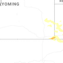
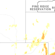


Connect with Interactive Hail Maps