

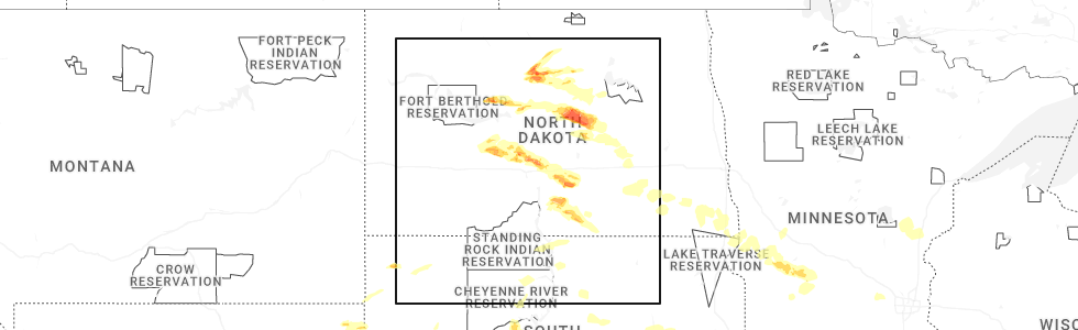
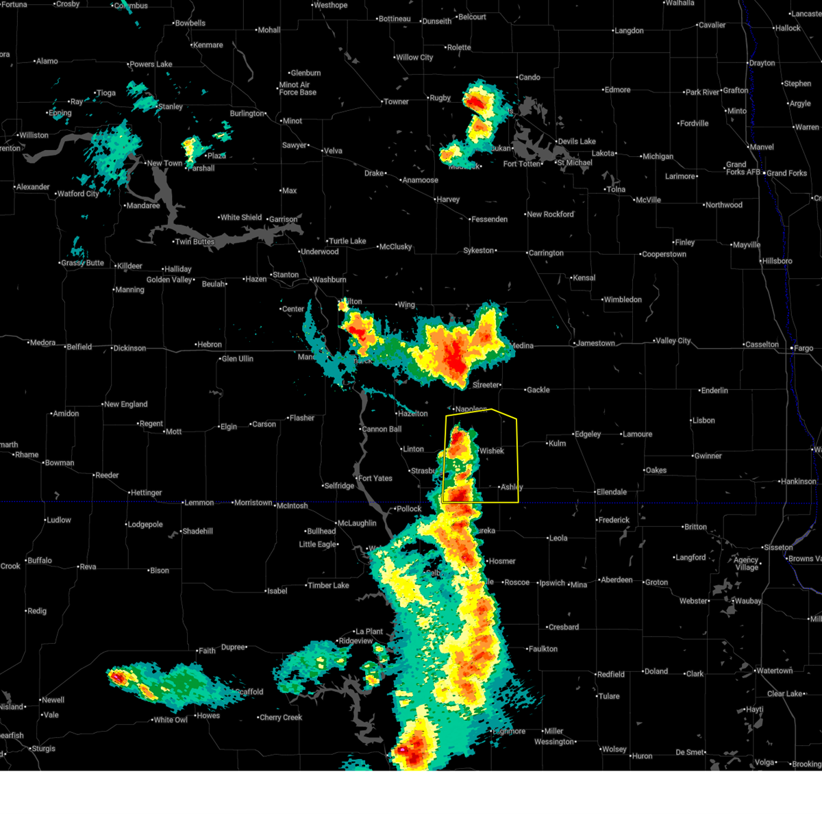
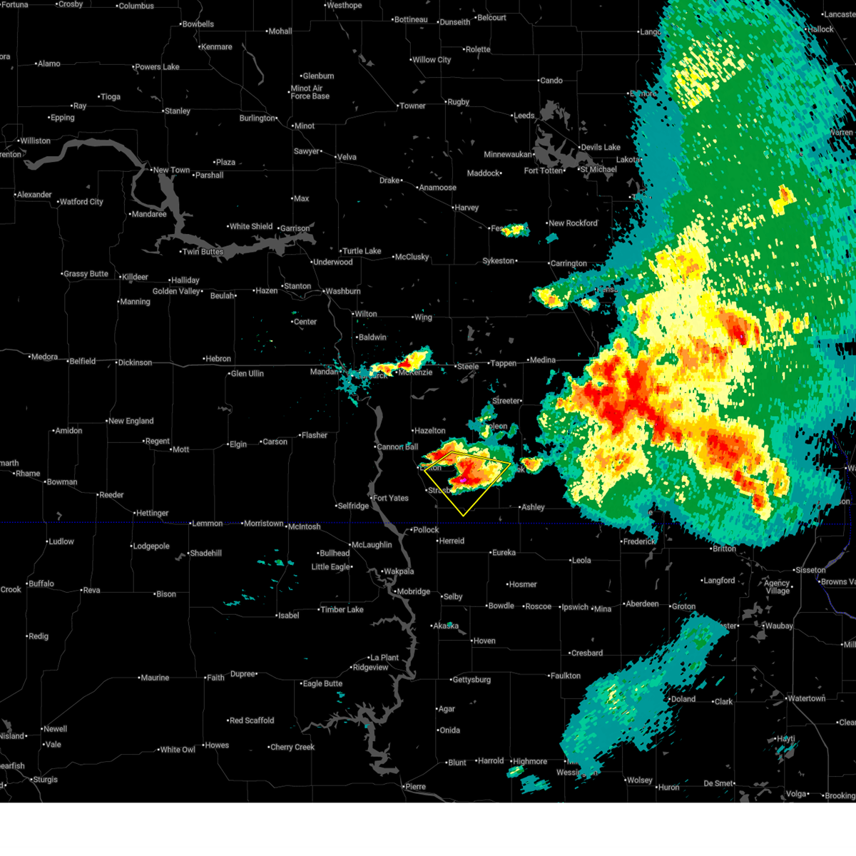
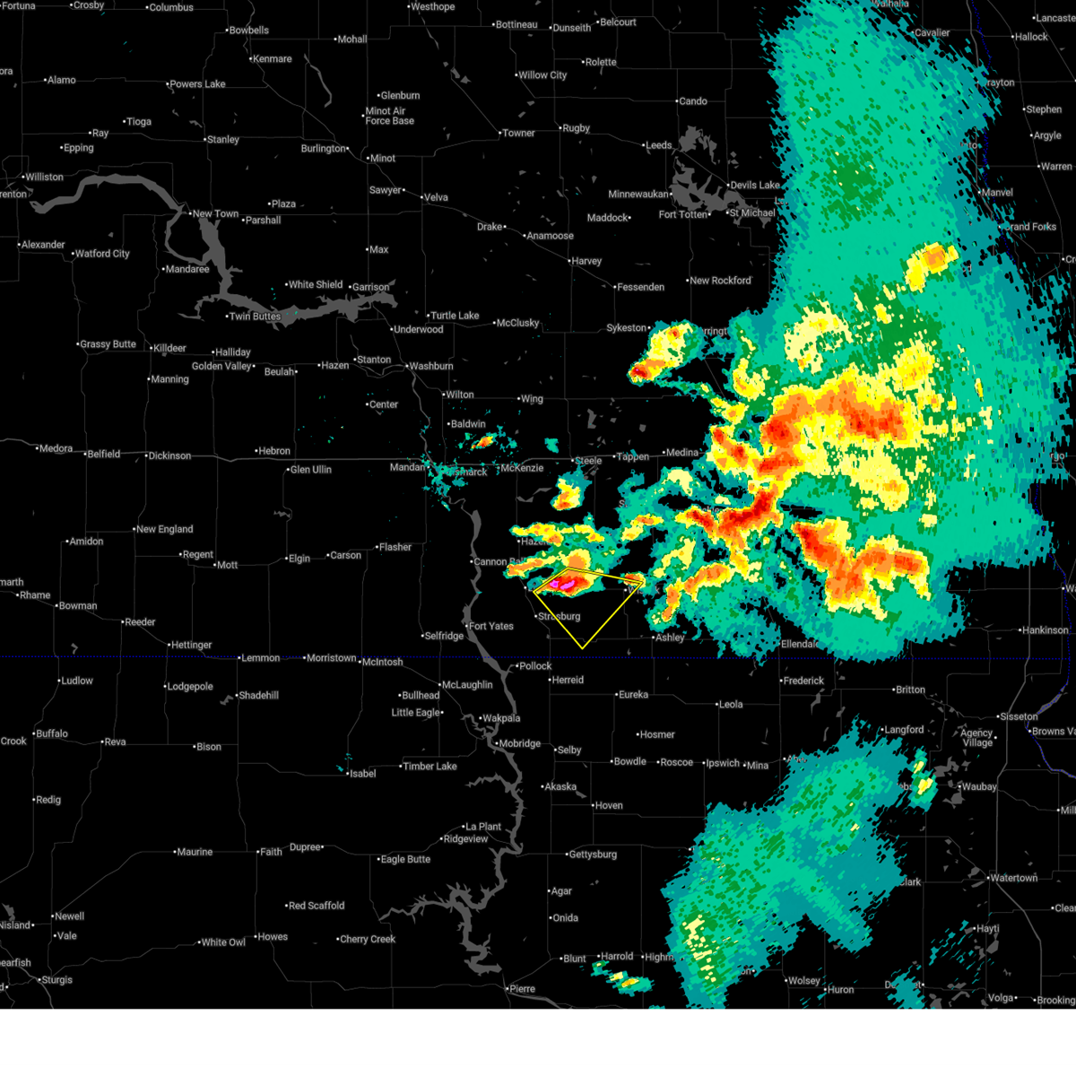
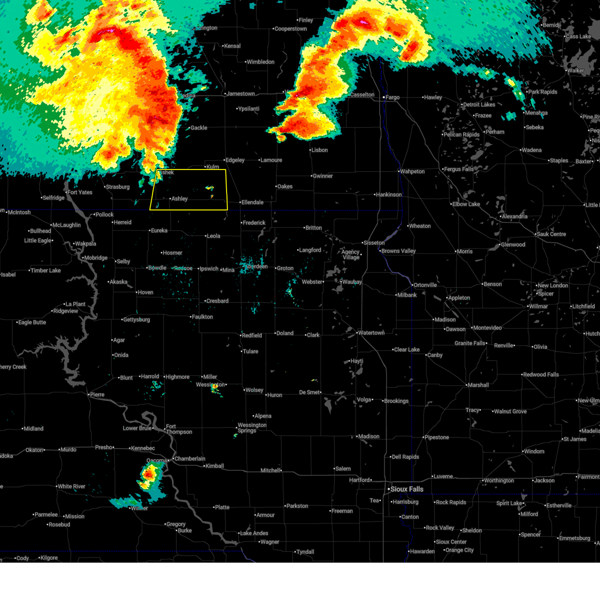
Hail Map for Wishek, ND
The Wishek, ND area has had 15 reports of on-the-ground hail by trained spotters, and has been under severe weather warnings 9 times during the past 12 months. Doppler radar has detected hail at or near Wishek, ND on 66 occasions, including 1 occasion during the past year.
| Name: | Wishek, ND |
| Where Located: | 69.5 miles ESE of Bismarck, ND |
| Map: | Google Map for Wishek, ND |
| Population: | 1002 |
| Housing Units: | 516 |
| More Info: | Search Google for Wishek, ND |
2
The Top Recent Hail Date for Wishek, ND is Friday, June 27, 2025 (12th out of 66)
Hail and Wind Damage Spotted near Wishek, ND
| Date / Time | Report Details |
|---|---|
| 7/9/2025 9:09 PM CDT |
 The storms which prompted the warning have weakened below severe limits, and no longer pose an immediate threat to life or property. therefore, the warning will be allowed to expire. however, small hail is still possible with these thunderstorms. a severe thunderstorm watch remains in effect until 100 am cdt for southeastern north dakota. The storms which prompted the warning have weakened below severe limits, and no longer pose an immediate threat to life or property. therefore, the warning will be allowed to expire. however, small hail is still possible with these thunderstorms. a severe thunderstorm watch remains in effect until 100 am cdt for southeastern north dakota.
|
| 7/9/2025 9:01 PM CDT |
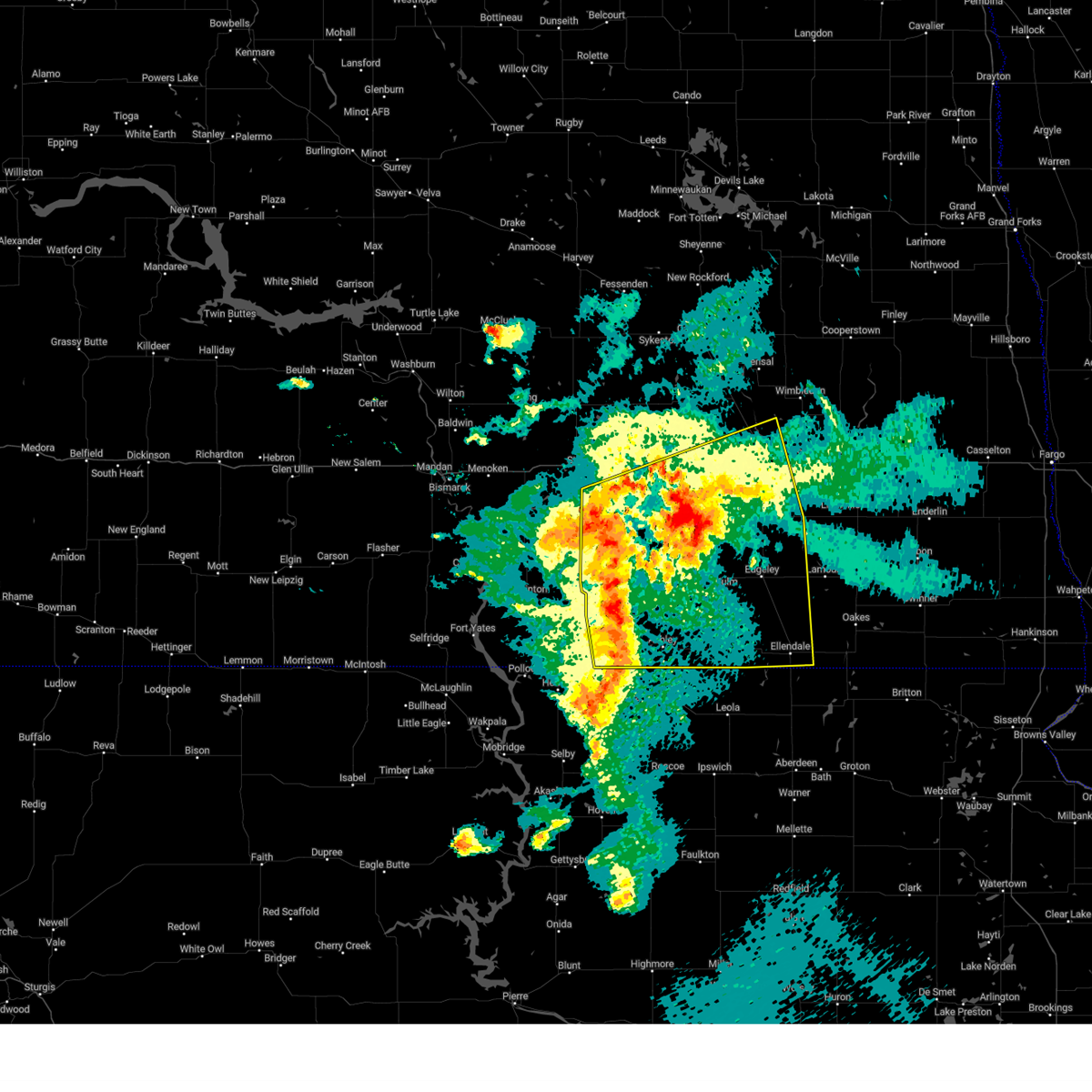
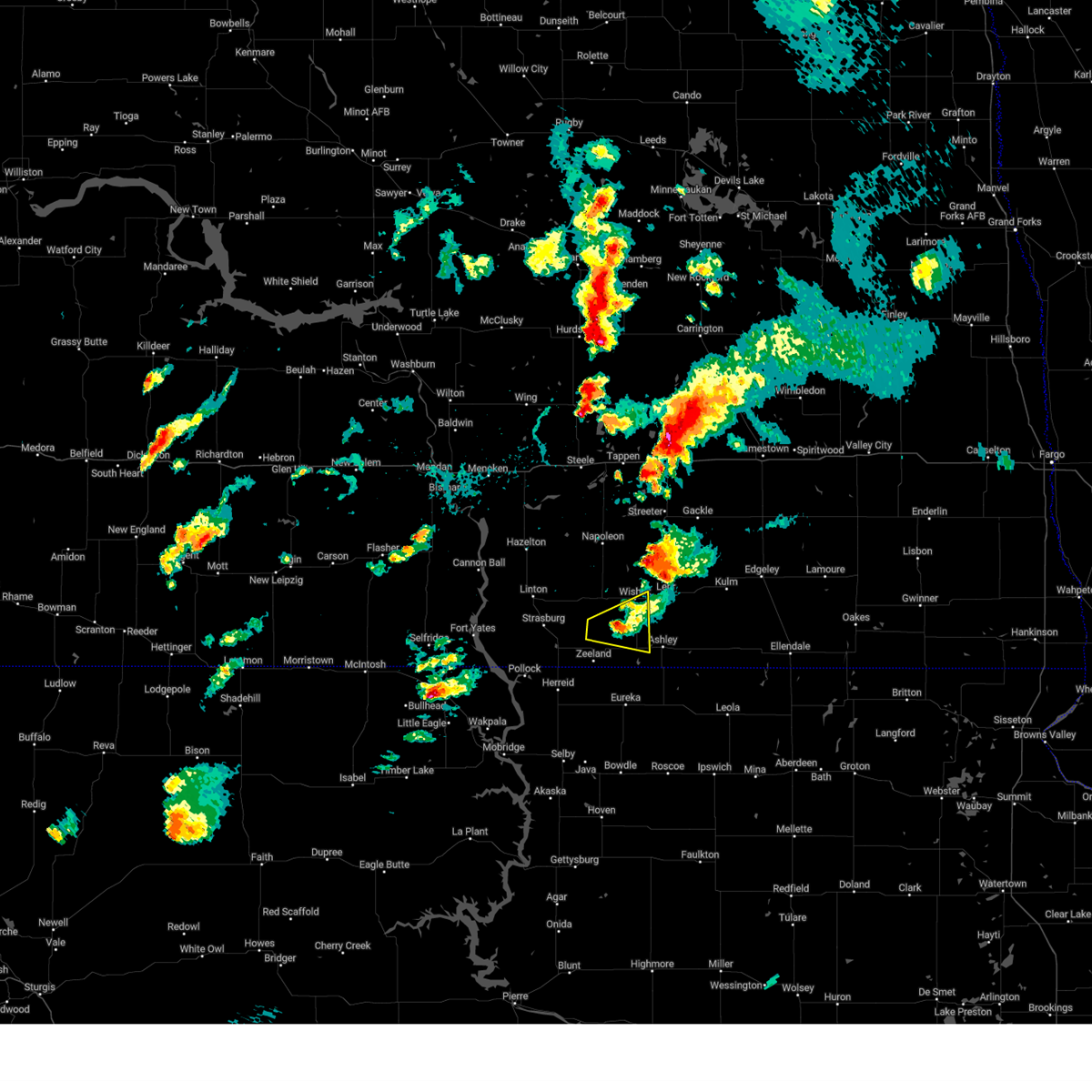
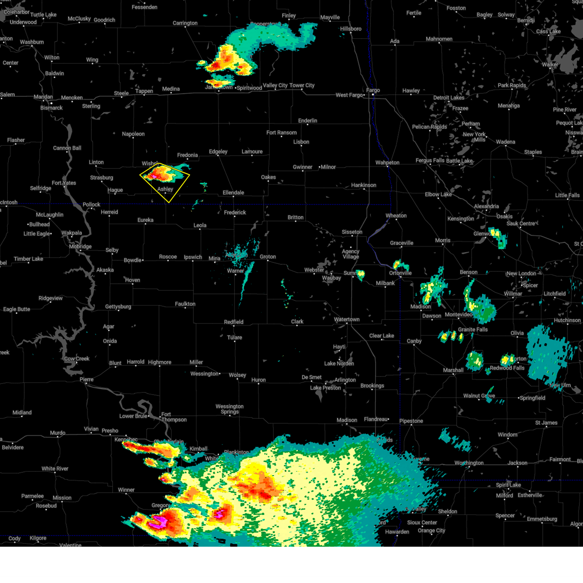
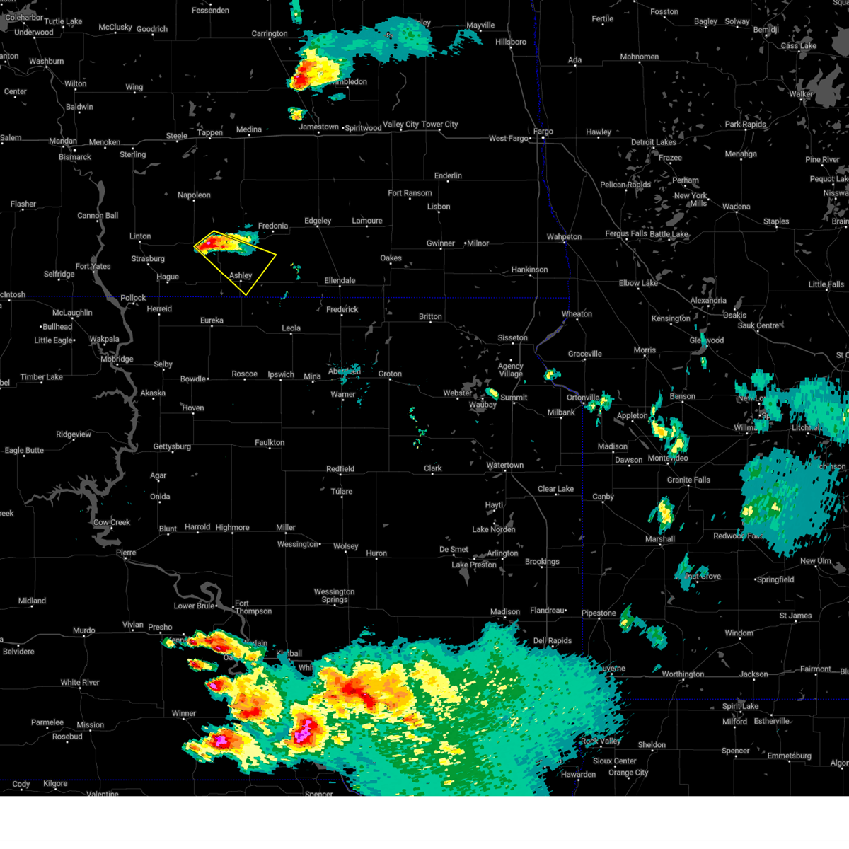
 At 900 pm cdt, severe thunderstorms were located along a line extending from 5 miles northwest of lehr to 4 miles southwest of ashley, moving east at 25 mph (radar indicated). Hazards include 60 mph wind gusts and quarter size hail. Hail damage to vehicles is expected. expect wind damage to roofs, siding, and trees. Locations impacted include, wishek, ashley, lehr, venturia, burnstad, green lake, danzig, and beaver lake state park. At 900 pm cdt, severe thunderstorms were located along a line extending from 5 miles northwest of lehr to 4 miles southwest of ashley, moving east at 25 mph (radar indicated). Hazards include 60 mph wind gusts and quarter size hail. Hail damage to vehicles is expected. expect wind damage to roofs, siding, and trees. Locations impacted include, wishek, ashley, lehr, venturia, burnstad, green lake, danzig, and beaver lake state park.
|
| 7/9/2025 8:42 PM CDT |
 At 842 pm cdt, severe thunderstorms were located along a line extending from 4 miles north of wishek to venturia, moving east at 25 mph (radar indicated). Hazards include 60 mph wind gusts and quarter size hail. Hail damage to vehicles is expected. expect wind damage to roofs, siding, and trees. Locations impacted include, wishek, ashley, lehr, venturia, burnstad, green lake, danzig, and beaver lake state park. At 842 pm cdt, severe thunderstorms were located along a line extending from 4 miles north of wishek to venturia, moving east at 25 mph (radar indicated). Hazards include 60 mph wind gusts and quarter size hail. Hail damage to vehicles is expected. expect wind damage to roofs, siding, and trees. Locations impacted include, wishek, ashley, lehr, venturia, burnstad, green lake, danzig, and beaver lake state park.
|
| 7/9/2025 8:21 PM CDT |
 Svrbis the national weather service in bismarck has issued a * severe thunderstorm warning for, southern logan county in southeastern north dakota, mcintosh county in southeastern north dakota, * until 915 pm cdt. * at 820 pm cdt, severe thunderstorms were located along a line extending from 10 miles northwest of wishek to 4 miles east of zeeland, moving east at 25 mph (radar indicated). Hazards include 60 mph wind gusts and quarter size hail. Hail damage to vehicles is expected. Expect wind damage to roofs, siding, and trees. Svrbis the national weather service in bismarck has issued a * severe thunderstorm warning for, southern logan county in southeastern north dakota, mcintosh county in southeastern north dakota, * until 915 pm cdt. * at 820 pm cdt, severe thunderstorms were located along a line extending from 10 miles northwest of wishek to 4 miles east of zeeland, moving east at 25 mph (radar indicated). Hazards include 60 mph wind gusts and quarter size hail. Hail damage to vehicles is expected. Expect wind damage to roofs, siding, and trees.
|
| 6/28/2025 12:51 AM CDT |
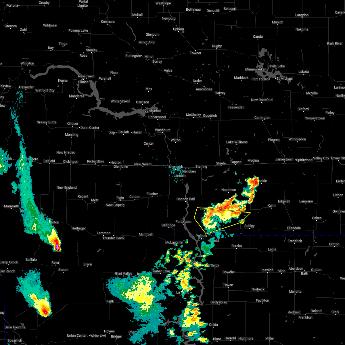
 At 1251 am cdt, a severe thunderstorm was located 11 miles west of wishek, or 20 miles east of linton, moving east at 20 mph (radar indicated). Hazards include 60 mph wind gusts and half dollar size hail. Hail damage to vehicles is expected. expect wind damage to roofs, siding, and trees. Locations impacted include, wishek. At 1251 am cdt, a severe thunderstorm was located 11 miles west of wishek, or 20 miles east of linton, moving east at 20 mph (radar indicated). Hazards include 60 mph wind gusts and half dollar size hail. Hail damage to vehicles is expected. expect wind damage to roofs, siding, and trees. Locations impacted include, wishek.
|
| 6/28/2025 12:27 AM CDT |
 Svrbis the national weather service in bismarck has issued a * severe thunderstorm warning for, southwestern logan county in southeastern north dakota, northwestern mcintosh county in southeastern north dakota, east central emmons county in south central north dakota, * until 115 am cdt. * at 1226 am cdt, a severe thunderstorm was located 12 miles east of linton, moving east at 20 mph (radar indicated). Hazards include ping pong ball size hail and 60 mph wind gusts. People and animals outdoors will be injured. expect hail damage to roofs, siding, windows, and vehicles. Expect wind damage to roofs, siding, and trees. Svrbis the national weather service in bismarck has issued a * severe thunderstorm warning for, southwestern logan county in southeastern north dakota, northwestern mcintosh county in southeastern north dakota, east central emmons county in south central north dakota, * until 115 am cdt. * at 1226 am cdt, a severe thunderstorm was located 12 miles east of linton, moving east at 20 mph (radar indicated). Hazards include ping pong ball size hail and 60 mph wind gusts. People and animals outdoors will be injured. expect hail damage to roofs, siding, windows, and vehicles. Expect wind damage to roofs, siding, and trees.
|
| 6/20/2025 10:12 PM CDT |
 Svrbis the national weather service in bismarck has issued a * severe thunderstorm warning for, western dickey county in southeastern north dakota, mcintosh county in southeastern north dakota, * until 1045 pm cdt. * at 1012 pm cdt, severe thunderstorms were located along a line extending from 5 miles northwest of lehr to near ashley, moving east at 75 mph (radar indicated). Hazards include 70 mph wind gusts. Expect considerable tree damage. Damage is likely to mobile homes, roofs, and outbuildings. Svrbis the national weather service in bismarck has issued a * severe thunderstorm warning for, western dickey county in southeastern north dakota, mcintosh county in southeastern north dakota, * until 1045 pm cdt. * at 1012 pm cdt, severe thunderstorms were located along a line extending from 5 miles northwest of lehr to near ashley, moving east at 75 mph (radar indicated). Hazards include 70 mph wind gusts. Expect considerable tree damage. Damage is likely to mobile homes, roofs, and outbuildings.
|
| 6/20/2025 10:00 PM CDT | 10 meter measured wind gust ndawn wishek 5 in mcintosh county ND, 5.5 miles E of Wishek, ND |
| 6/16/2025 3:44 AM CDT | 5 w wishek ndawn. 10 meter peak wind gus in mcintosh county ND, 5.5 miles E of Wishek, ND |
| 7/29/2024 9:47 PM CDT |
 At 946 pm cdt, severe thunderstorms were located along a line extending from 7 miles southwest of medina to 12 miles south of gackle to 5 miles north of long lake, moving east at 50 mph (radar indicated). Hazards include 60 mph wind gusts. Expect damage to roofs, siding, and trees. these severe storms will be near, gackle around 950 pm cdt. kulm and jud around 955 pm cdt. cleveland around 1000 pm cdt. edgeley, forbes, and merricourt city around 1005 pm cdt. jamestown, ellendale, adrian, montpelier, and dickey around 1020 pm cdt. ypsilanti and fullerton around 1025 pm cdt. Other locations impacted by these severe thunderstorms include eldridge, monango, fredonia, berlin, windsor, merricourt, millarton, nortonville, green lake, and danzig. At 946 pm cdt, severe thunderstorms were located along a line extending from 7 miles southwest of medina to 12 miles south of gackle to 5 miles north of long lake, moving east at 50 mph (radar indicated). Hazards include 60 mph wind gusts. Expect damage to roofs, siding, and trees. these severe storms will be near, gackle around 950 pm cdt. kulm and jud around 955 pm cdt. cleveland around 1000 pm cdt. edgeley, forbes, and merricourt city around 1005 pm cdt. jamestown, ellendale, adrian, montpelier, and dickey around 1020 pm cdt. ypsilanti and fullerton around 1025 pm cdt. Other locations impacted by these severe thunderstorms include eldridge, monango, fredonia, berlin, windsor, merricourt, millarton, nortonville, green lake, and danzig.
|
| 7/29/2024 9:23 PM CDT |
 Svrbis the national weather service in bismarck has issued a * severe thunderstorm warning for, lamoure county in southeastern north dakota, dickey county in southeastern north dakota, southeastern kidder county in south central north dakota, logan county in southeastern north dakota, mcintosh county in southeastern north dakota, southern stutsman county in southeastern north dakota, * until 1030 pm cdt. * at 922 pm cdt, severe thunderstorms were located along a line extending from 4 miles southeast of lake isabel to 13 miles southwest of streeter to 7 miles southeast of venturia, moving east at 50 mph (public. at 858 pm a 59 mph wind gust was reported in napoleon). Hazards include 60 mph wind gusts. expect damage to roofs, siding, and trees Svrbis the national weather service in bismarck has issued a * severe thunderstorm warning for, lamoure county in southeastern north dakota, dickey county in southeastern north dakota, southeastern kidder county in south central north dakota, logan county in southeastern north dakota, mcintosh county in southeastern north dakota, southern stutsman county in southeastern north dakota, * until 1030 pm cdt. * at 922 pm cdt, severe thunderstorms were located along a line extending from 4 miles southeast of lake isabel to 13 miles southwest of streeter to 7 miles southeast of venturia, moving east at 50 mph (public. at 858 pm a 59 mph wind gust was reported in napoleon). Hazards include 60 mph wind gusts. expect damage to roofs, siding, and trees
|
| 6/18/2024 1:59 AM CDT |
 At 158 am cdt, severe thunderstorms were located along a line extending from near marion to 8 miles north of fullerton to forbes, moving east at 35 mph (radar indicated). Hazards include 60 mph wind gusts and penny size hail. Expect damage to roofs, siding, and trees. Locations impacted include, ellendale, oakes, wishek, lamoure, ashley, edgeley, kulm, gackle, marion, la moure, adrian, zeeland, verona, lehr, jud, fullerton, forbes, dickey, ludden, and venturia. At 158 am cdt, severe thunderstorms were located along a line extending from near marion to 8 miles north of fullerton to forbes, moving east at 35 mph (radar indicated). Hazards include 60 mph wind gusts and penny size hail. Expect damage to roofs, siding, and trees. Locations impacted include, ellendale, oakes, wishek, lamoure, ashley, edgeley, kulm, gackle, marion, la moure, adrian, zeeland, verona, lehr, jud, fullerton, forbes, dickey, ludden, and venturia.
|
| 6/18/2024 1:39 AM CDT |
 Svrbis the national weather service in bismarck has issued a * severe thunderstorm warning for, lamoure county in southeastern north dakota, dickey county in southeastern north dakota, eastern logan county in southeastern north dakota, mcintosh county in southeastern north dakota, * until 245 am cdt. * at 138 am cdt, severe thunderstorms were located along a line extending from near adrian to 5 miles northeast of merricourt city to 6 miles northwest of spring creek colony, moving east at 40 mph (radar indicated). Hazards include 70 mph wind gusts and penny size hail. Expect considerable tree damage. Damage is likely to mobile homes, roofs, and outbuildings. Svrbis the national weather service in bismarck has issued a * severe thunderstorm warning for, lamoure county in southeastern north dakota, dickey county in southeastern north dakota, eastern logan county in southeastern north dakota, mcintosh county in southeastern north dakota, * until 245 am cdt. * at 138 am cdt, severe thunderstorms were located along a line extending from near adrian to 5 miles northeast of merricourt city to 6 miles northwest of spring creek colony, moving east at 40 mph (radar indicated). Hazards include 70 mph wind gusts and penny size hail. Expect considerable tree damage. Damage is likely to mobile homes, roofs, and outbuildings.
|
| 6/18/2024 1:26 AM CDT |
 At 126 am cdt, severe thunderstorms were located along a line extending from near adrian to near kulm to 5 miles south of ashley, moving east at 40 mph (radar indicated). Hazards include 70 mph wind gusts and nickel size hail. Expect considerable tree damage. damage is likely to mobile homes, roofs, and outbuildings. Locations impacted include, wishek, lamoure, ashley, edgeley, kulm, gackle, marion, la moure, adrian, zeeland, lehr, jud, hague, dickey, venturia, la moure city, merricourt city, grand rapids, fredonia, and monango. At 126 am cdt, severe thunderstorms were located along a line extending from near adrian to near kulm to 5 miles south of ashley, moving east at 40 mph (radar indicated). Hazards include 70 mph wind gusts and nickel size hail. Expect considerable tree damage. damage is likely to mobile homes, roofs, and outbuildings. Locations impacted include, wishek, lamoure, ashley, edgeley, kulm, gackle, marion, la moure, adrian, zeeland, lehr, jud, hague, dickey, venturia, la moure city, merricourt city, grand rapids, fredonia, and monango.
|
| 6/18/2024 1:13 AM CDT |
 At 113 am cdt, severe thunderstorms were located along a line extending from 8 miles northeast of jud to 4 miles west of kulm to near venturia, moving east at 40 mph (radar indicated). Hazards include 70 mph wind gusts and quarter size hail. Hail damage to vehicles is expected. expect considerable tree damage. wind damage is also likely to mobile homes, roofs, and outbuildings. Locations impacted include, wishek, lamoure, ashley, edgeley, kulm, gackle, marion, la moure, adrian, zeeland, lehr, jud, hague, dickey, venturia, la moure city, merricourt city, grand rapids, fredonia, and monango. At 113 am cdt, severe thunderstorms were located along a line extending from 8 miles northeast of jud to 4 miles west of kulm to near venturia, moving east at 40 mph (radar indicated). Hazards include 70 mph wind gusts and quarter size hail. Hail damage to vehicles is expected. expect considerable tree damage. wind damage is also likely to mobile homes, roofs, and outbuildings. Locations impacted include, wishek, lamoure, ashley, edgeley, kulm, gackle, marion, la moure, adrian, zeeland, lehr, jud, hague, dickey, venturia, la moure city, merricourt city, grand rapids, fredonia, and monango.
|
| 6/18/2024 12:58 AM CDT |
 At 1257 am cdt, severe thunderstorms were located along a line extending from 7 miles northwest of jud to 6 miles east of lehr to near greenway, moving east at 40 mph (radar indicated). Hazards include 60 mph wind gusts and quarter size hail. Hail damage to vehicles is expected. expect wind damage to roofs, siding, and trees. Locations impacted include, wishek, lamoure, napoleon, ashley, edgeley, strasburg, kulm, gackle, marion, la moure, adrian, zeeland, lehr, jud, hague, westfield, dickey, venturia, la moure city, and merricourt city. At 1257 am cdt, severe thunderstorms were located along a line extending from 7 miles northwest of jud to 6 miles east of lehr to near greenway, moving east at 40 mph (radar indicated). Hazards include 60 mph wind gusts and quarter size hail. Hail damage to vehicles is expected. expect wind damage to roofs, siding, and trees. Locations impacted include, wishek, lamoure, napoleon, ashley, edgeley, strasburg, kulm, gackle, marion, la moure, adrian, zeeland, lehr, jud, hague, westfield, dickey, venturia, la moure city, and merricourt city.
|
| 6/18/2024 12:44 AM CDT |
 Svrbis the national weather service in bismarck has issued a * severe thunderstorm warning for, lamoure county in southeastern north dakota, western dickey county in southeastern north dakota, logan county in southeastern north dakota, mcintosh county in southeastern north dakota, southeastern emmons county in south central north dakota, * until 145 am cdt. * at 1243 am cdt, severe thunderstorms were located along a line extending from gackle to near lehr to near zeeland, moving east at 40 mph (radar indicated). Hazards include 60 mph wind gusts and quarter size hail. Hail damage to vehicles is expected. Expect wind damage to roofs, siding, and trees. Svrbis the national weather service in bismarck has issued a * severe thunderstorm warning for, lamoure county in southeastern north dakota, western dickey county in southeastern north dakota, logan county in southeastern north dakota, mcintosh county in southeastern north dakota, southeastern emmons county in south central north dakota, * until 145 am cdt. * at 1243 am cdt, severe thunderstorms were located along a line extending from gackle to near lehr to near zeeland, moving east at 40 mph (radar indicated). Hazards include 60 mph wind gusts and quarter size hail. Hail damage to vehicles is expected. Expect wind damage to roofs, siding, and trees.
|
| 6/2/2024 3:50 PM CDT |
 The storm which prompted the warning has weakened below severe limits, and no longer poses an immediate threat to life or property. therefore, the warning will be allowed to expire. a severe thunderstorm watch remains in effect until 1000 pm cdt for south central and southeastern north dakota. The storm which prompted the warning has weakened below severe limits, and no longer poses an immediate threat to life or property. therefore, the warning will be allowed to expire. a severe thunderstorm watch remains in effect until 1000 pm cdt for south central and southeastern north dakota.
|
| 6/2/2024 3:30 PM CDT | Quarter sized hail reported 9.7 miles SSW of Wishek, ND, mostly pea sized hail with some quarter sized hail mixed in. also rain around 2.4 inches over the course of an hour... 2:30-3:30 pm cdt. culverts were observed to be ru |
| 6/2/2024 3:15 PM CDT |
 the severe thunderstorm warning has been cancelled and is no longer in effect the severe thunderstorm warning has been cancelled and is no longer in effect
|
| 6/2/2024 3:15 PM CDT |
 At 315 pm cdt, a severe thunderstorm was located 11 miles southwest of wishek, or 25 miles east of linton, moving northeast at 25 mph (radar indicated). Hazards include 60 mph wind gusts and quarter size hail. Hail damage to vehicles is expected. expect wind damage to roofs, siding, and trees. Locations impacted include, wishek, green lake, and danzig. At 315 pm cdt, a severe thunderstorm was located 11 miles southwest of wishek, or 25 miles east of linton, moving northeast at 25 mph (radar indicated). Hazards include 60 mph wind gusts and quarter size hail. Hail damage to vehicles is expected. expect wind damage to roofs, siding, and trees. Locations impacted include, wishek, green lake, and danzig.
|
| 6/2/2024 2:57 PM CDT |
 Svrbis the national weather service in bismarck has issued a * severe thunderstorm warning for, western mcintosh county in southeastern north dakota, eastern emmons county in south central north dakota, * until 400 pm cdt. * at 256 pm cdt, a severe thunderstorm was located 7 miles north of zeeland, or 20 miles northeast of herreid, moving northeast at 25 mph (radar indicated). Hazards include 60 mph wind gusts and half dollar size hail. Hail damage to vehicles is expected. Expect wind damage to roofs, siding, and trees. Svrbis the national weather service in bismarck has issued a * severe thunderstorm warning for, western mcintosh county in southeastern north dakota, eastern emmons county in south central north dakota, * until 400 pm cdt. * at 256 pm cdt, a severe thunderstorm was located 7 miles north of zeeland, or 20 miles northeast of herreid, moving northeast at 25 mph (radar indicated). Hazards include 60 mph wind gusts and half dollar size hail. Hail damage to vehicles is expected. Expect wind damage to roofs, siding, and trees.
|
| 5/23/2024 6:57 PM CDT |
 Svrbis the national weather service in bismarck has issued a * severe thunderstorm warning for, western lamoure county in southeastern north dakota, eastern logan county in southeastern north dakota, northeastern mcintosh county in southeastern north dakota, south central stutsman county in southeastern north dakota, * until 745 pm cdt. * at 656 pm cdt, severe thunderstorms were located along a line extending from 4 miles north of gackle to 11 miles northeast of lehr to 6 miles southeast of wishek, moving east at 30 mph (radar indicated). Hazards include 60 mph wind gusts and half dollar size hail. Hail damage to vehicles is expected. Expect wind damage to roofs, siding, and trees. Svrbis the national weather service in bismarck has issued a * severe thunderstorm warning for, western lamoure county in southeastern north dakota, eastern logan county in southeastern north dakota, northeastern mcintosh county in southeastern north dakota, south central stutsman county in southeastern north dakota, * until 745 pm cdt. * at 656 pm cdt, severe thunderstorms were located along a line extending from 4 miles north of gackle to 11 miles northeast of lehr to 6 miles southeast of wishek, moving east at 30 mph (radar indicated). Hazards include 60 mph wind gusts and half dollar size hail. Hail damage to vehicles is expected. Expect wind damage to roofs, siding, and trees.
|
| 5/23/2024 6:50 PM CDT | Quarter sized hail reported 0.3 miles SE of Wishek, ND, hail to the size of quarters began at 650 pm and lasted 5 minutes until 655 pm. |
| 5/23/2024 6:42 PM CDT | Quarter sized hail reported 7.7 miles SSW of Wishek, ND, hail began at 642 pm and lasted 25 minutes until 707 pm. lots of dime to nickel sized hail... with some hailstones up to the size of quarters. |
| 5/23/2024 6:38 PM CDT |
 the severe thunderstorm warning has been cancelled and is no longer in effect the severe thunderstorm warning has been cancelled and is no longer in effect
|
| 5/23/2024 6:38 PM CDT |
 At 637 pm cdt, a severe thunderstorm was located over wishek, or 30 miles east of linton, moving east at 30 mph (radar indicated). Hazards include 60 mph wind gusts and half dollar size hail. Hail damage to vehicles is expected. expect wind damage to roofs, siding, and trees. Locations impacted include, wishek, lehr, burnstad, green lake, danzig, and beaver lake state park. At 637 pm cdt, a severe thunderstorm was located over wishek, or 30 miles east of linton, moving east at 30 mph (radar indicated). Hazards include 60 mph wind gusts and half dollar size hail. Hail damage to vehicles is expected. expect wind damage to roofs, siding, and trees. Locations impacted include, wishek, lehr, burnstad, green lake, danzig, and beaver lake state park.
|
| 5/23/2024 6:22 PM CDT |
 At 622 pm cdt, a severe thunderstorm was located 8 miles west of wishek, or 24 miles east of linton, moving east at 35 mph (radar indicated). Hazards include 60 mph wind gusts and half dollar size hail. Hail damage to vehicles is expected. expect wind damage to roofs, siding, and trees. Locations impacted include, wishek, lehr, burnstad, green lake, danzig, and beaver lake state park. At 622 pm cdt, a severe thunderstorm was located 8 miles west of wishek, or 24 miles east of linton, moving east at 35 mph (radar indicated). Hazards include 60 mph wind gusts and half dollar size hail. Hail damage to vehicles is expected. expect wind damage to roofs, siding, and trees. Locations impacted include, wishek, lehr, burnstad, green lake, danzig, and beaver lake state park.
|
| 5/23/2024 6:07 PM CDT |
 Svrbis the national weather service in bismarck has issued a * severe thunderstorm warning for, southwestern logan county in southeastern north dakota, northwestern mcintosh county in southeastern north dakota, east central emmons county in south central north dakota, * until 700 pm cdt. * at 607 pm cdt, a severe thunderstorm was located 12 miles north of hague, or 16 miles east of linton, moving east at 35 mph (radar indicated). Hazards include 60 mph wind gusts and half dollar size hail. Hail damage to vehicles is expected. Expect wind damage to roofs, siding, and trees. Svrbis the national weather service in bismarck has issued a * severe thunderstorm warning for, southwestern logan county in southeastern north dakota, northwestern mcintosh county in southeastern north dakota, east central emmons county in south central north dakota, * until 700 pm cdt. * at 607 pm cdt, a severe thunderstorm was located 12 miles north of hague, or 16 miles east of linton, moving east at 35 mph (radar indicated). Hazards include 60 mph wind gusts and half dollar size hail. Hail damage to vehicles is expected. Expect wind damage to roofs, siding, and trees.
|
| 5/23/2024 6:00 PM CDT | 3-5 inch tree limbs blown dow in mcintosh county ND, 12.1 miles NE of Wishek, ND |
| 5/17/2024 9:27 PM CDT |
 The storm which prompted the warning has weakened below severe limits, and has exited the warned area. therefore, the warning will be allowed to expire. a severe thunderstorm watch remains in effect until midnight cdt for southeastern north dakota. The storm which prompted the warning has weakened below severe limits, and has exited the warned area. therefore, the warning will be allowed to expire. a severe thunderstorm watch remains in effect until midnight cdt for southeastern north dakota.
|
| 5/17/2024 9:15 PM CDT |
 At 915 pm cdt, a severe thunderstorm was located 5 miles northeast of ashley, or 26 miles northeast of eureka, moving east at 45 mph (radar indicated). Hazards include 60 mph wind gusts. Expect damage to roofs, siding, and trees. Locations impacted include, wishek, ashley, lehr, green lake, and danzig. At 915 pm cdt, a severe thunderstorm was located 5 miles northeast of ashley, or 26 miles northeast of eureka, moving east at 45 mph (radar indicated). Hazards include 60 mph wind gusts. Expect damage to roofs, siding, and trees. Locations impacted include, wishek, ashley, lehr, green lake, and danzig.
|
| 5/17/2024 9:02 PM CDT |
 At 901 pm cdt, a severe thunderstorm was located 5 miles west of ashley, or 20 miles northeast of eureka, moving east at 45 mph (radar indicated). Hazards include 60 mph wind gusts. Expect damage to roofs, siding, and trees. Locations impacted include, wishek, ashley, lehr, venturia, green lake, and danzig. At 901 pm cdt, a severe thunderstorm was located 5 miles west of ashley, or 20 miles northeast of eureka, moving east at 45 mph (radar indicated). Hazards include 60 mph wind gusts. Expect damage to roofs, siding, and trees. Locations impacted include, wishek, ashley, lehr, venturia, green lake, and danzig.
|
| 5/17/2024 8:46 PM CDT |
 Svrbis the national weather service in bismarck has issued a * severe thunderstorm warning for, mcintosh county in southeastern north dakota, * until 930 pm cdt. * at 845 pm cdt, a severe thunderstorm was located 5 miles east of zeeland, or 16 miles north of eureka, moving northeast at 40 mph (observations). Hazards include 60 mph wind gusts. expect damage to roofs, siding, and trees Svrbis the national weather service in bismarck has issued a * severe thunderstorm warning for, mcintosh county in southeastern north dakota, * until 930 pm cdt. * at 845 pm cdt, a severe thunderstorm was located 5 miles east of zeeland, or 16 miles north of eureka, moving northeast at 40 mph (observations). Hazards include 60 mph wind gusts. expect damage to roofs, siding, and trees
|
| 7/18/2023 10:10 PM CDT |
 At 1010 pm cdt, a severe thunderstorm was located 7 miles southeast of wishek, or 28 miles north of eureka, moving southeast at 30 mph (radar indicated). Hazards include golf ball size hail. People and animals outdoors will be injured. expect damage to roofs, siding, windows, and vehicles. this severe storm will be near, ashley around 1025 pm cdt. other locations impacted by this severe thunderstorm include green lake and danzig. thunderstorm damage threat, considerable hail threat, radar indicated max hail size, 1. 75 in wind threat, radar indicated max wind gust, <50 mph. At 1010 pm cdt, a severe thunderstorm was located 7 miles southeast of wishek, or 28 miles north of eureka, moving southeast at 30 mph (radar indicated). Hazards include golf ball size hail. People and animals outdoors will be injured. expect damage to roofs, siding, windows, and vehicles. this severe storm will be near, ashley around 1025 pm cdt. other locations impacted by this severe thunderstorm include green lake and danzig. thunderstorm damage threat, considerable hail threat, radar indicated max hail size, 1. 75 in wind threat, radar indicated max wind gust, <50 mph.
|
| 7/18/2023 9:54 PM CDT |
 At 954 pm cdt, a severe thunderstorm was located over wishek, or 30 miles east of linton, moving southeast at 25 mph (radar indicated). Hazards include golf ball size hail. People and animals outdoors will be injured. expect damage to roofs, siding, windows, and vehicles. this severe thunderstorm will be near, ashley around 1030 pm cdt. other locations impacted by this severe thunderstorm include green lake and danzig. thunderstorm damage threat, considerable hail threat, radar indicated max hail size, 1. 75 in wind threat, radar indicated max wind gust, <50 mph. At 954 pm cdt, a severe thunderstorm was located over wishek, or 30 miles east of linton, moving southeast at 25 mph (radar indicated). Hazards include golf ball size hail. People and animals outdoors will be injured. expect damage to roofs, siding, windows, and vehicles. this severe thunderstorm will be near, ashley around 1030 pm cdt. other locations impacted by this severe thunderstorm include green lake and danzig. thunderstorm damage threat, considerable hail threat, radar indicated max hail size, 1. 75 in wind threat, radar indicated max wind gust, <50 mph.
|
| 7/21/2022 6:05 PM CDT |
 At 604 pm cdt, a severe thunderstorm was located over lehr, or 16 miles north of ashley, moving southeast at 40 mph (trained weather spotters). Hazards include 60 mph wind gusts and quarter size hail. Hail damage to vehicles is expected. expect wind damage to roofs, siding, and trees. locations impacted include, wishek, lehr, fredonia, green lake and danzig. hail threat, observed max hail size, 1. 00 in wind threat, radar indicated max wind gust, 60 mph. At 604 pm cdt, a severe thunderstorm was located over lehr, or 16 miles north of ashley, moving southeast at 40 mph (trained weather spotters). Hazards include 60 mph wind gusts and quarter size hail. Hail damage to vehicles is expected. expect wind damage to roofs, siding, and trees. locations impacted include, wishek, lehr, fredonia, green lake and danzig. hail threat, observed max hail size, 1. 00 in wind threat, radar indicated max wind gust, 60 mph.
|
| 7/21/2022 6:02 PM CDT | Half Dollar sized hail reported 5 miles S of Wishek, ND |
| 7/21/2022 5:59 PM CDT | Quarter sized hail reported 3.6 miles S of Wishek, ND |
| 7/21/2022 5:39 PM CDT |
 At 539 pm cdt, a severe thunderstorm was located 8 miles south of napoleon, moving southeast at 40 mph (radar indicated). Hazards include golf ball size hail and 60 mph wind gusts. People and animals outdoors will be injured. expect hail damage to roofs, siding, windows, and vehicles. Expect wind damage to roofs, siding, and trees. At 539 pm cdt, a severe thunderstorm was located 8 miles south of napoleon, moving southeast at 40 mph (radar indicated). Hazards include golf ball size hail and 60 mph wind gusts. People and animals outdoors will be injured. expect hail damage to roofs, siding, windows, and vehicles. Expect wind damage to roofs, siding, and trees.
|
| 7/10/2022 5:58 AM CDT |
 At 558 am cdt, a severe thunderstorm was located 7 miles southwest of napoleon, moving east at 50 mph (radar indicated). Hazards include 60 mph wind gusts and quarter size hail. Hail damage to vehicles is expected. expect wind damage to roofs, siding, and trees. locations impacted include, napoleon and beaver lake state park. hail threat, radar indicated max hail size, 1. 00 in wind threat, radar indicated max wind gust, 60 mph. At 558 am cdt, a severe thunderstorm was located 7 miles southwest of napoleon, moving east at 50 mph (radar indicated). Hazards include 60 mph wind gusts and quarter size hail. Hail damage to vehicles is expected. expect wind damage to roofs, siding, and trees. locations impacted include, napoleon and beaver lake state park. hail threat, radar indicated max hail size, 1. 00 in wind threat, radar indicated max wind gust, 60 mph.
|
| 7/10/2022 5:27 AM CDT |
 At 527 am cdt, a severe thunderstorm was located 5 miles west of hazelton, or 14 miles northwest of linton, moving east at 55 mph (radar indicated). Hazards include 70 mph wind gusts and half dollar size hail. Hail damage to vehicles is expected. expect considerable tree damage. wind damage is also likely to mobile homes, roofs, and outbuildings. this severe thunderstorm will be near, hazelton around 530 am cdt. braddock around 545 am cdt. other locations in the path of this severe thunderstorm include napoleon. thunderstorm damage threat, considerable hail threat, radar indicated max hail size, 1. 25 in wind threat, radar indicated max wind gust, 70 mph. At 527 am cdt, a severe thunderstorm was located 5 miles west of hazelton, or 14 miles northwest of linton, moving east at 55 mph (radar indicated). Hazards include 70 mph wind gusts and half dollar size hail. Hail damage to vehicles is expected. expect considerable tree damage. wind damage is also likely to mobile homes, roofs, and outbuildings. this severe thunderstorm will be near, hazelton around 530 am cdt. braddock around 545 am cdt. other locations in the path of this severe thunderstorm include napoleon. thunderstorm damage threat, considerable hail threat, radar indicated max hail size, 1. 25 in wind threat, radar indicated max wind gust, 70 mph.
|
| 6/29/2022 10:28 PM CDT |
 At 1028 pm cdt, a severe thunderstorm was located 9 miles south of napoleon, moving northeast at 40 mph (radar indicated). Hazards include 70 mph wind gusts and quarter size hail. Hail damage to vehicles is expected. expect considerable tree damage. wind damage is also likely to mobile homes, roofs, and outbuildings. locations impacted include, napoleon, wishek, burnstad, kintyre and beaver lake state park. thunderstorm damage threat, considerable hail threat, radar indicated max hail size, 1. 00 in wind threat, radar indicated max wind gust, 70 mph. At 1028 pm cdt, a severe thunderstorm was located 9 miles south of napoleon, moving northeast at 40 mph (radar indicated). Hazards include 70 mph wind gusts and quarter size hail. Hail damage to vehicles is expected. expect considerable tree damage. wind damage is also likely to mobile homes, roofs, and outbuildings. locations impacted include, napoleon, wishek, burnstad, kintyre and beaver lake state park. thunderstorm damage threat, considerable hail threat, radar indicated max hail size, 1. 00 in wind threat, radar indicated max wind gust, 70 mph.
|
| 6/29/2022 10:23 PM CDT |
 At 1023 pm cdt, a severe thunderstorm was located 11 miles south of napoleon, moving northeast at 35 mph (radar indicated). Hazards include 70 mph wind gusts and quarter size hail. Hail damage to vehicles is expected. expect considerable tree damage. Wind damage is also likely to mobile homes, roofs, and outbuildings. At 1023 pm cdt, a severe thunderstorm was located 11 miles south of napoleon, moving northeast at 35 mph (radar indicated). Hazards include 70 mph wind gusts and quarter size hail. Hail damage to vehicles is expected. expect considerable tree damage. Wind damage is also likely to mobile homes, roofs, and outbuildings.
|
| 6/29/2022 10:21 PM CDT | Mesonet station 329519 5 w wishek (ndawn in mcintosh county ND, 5.5 miles E of Wishek, ND |
| 6/29/2022 10:20 PM CDT | Wishek nddot site. gusts lasted 15 minute in mcintosh county ND, 9.3 miles E of Wishek, ND |
| 6/29/2022 10:16 PM CDT |
 At 1015 pm cdt, a severe thunderstorm was located 14 miles southwest of napoleon, moving northeast at 40 mph (radar indicated). Hazards include 70 mph wind gusts and penny size hail. Expect considerable tree damage. damage is likely to mobile homes, roofs, and outbuildings. locations impacted include, napoleon, wishek, hazelton, burnstad, temvik, kintyre and beaver lake state park. thunderstorm damage threat, considerable hail threat, radar indicated max hail size, 0. 75 in wind threat, radar indicated max wind gust, 70 mph. At 1015 pm cdt, a severe thunderstorm was located 14 miles southwest of napoleon, moving northeast at 40 mph (radar indicated). Hazards include 70 mph wind gusts and penny size hail. Expect considerable tree damage. damage is likely to mobile homes, roofs, and outbuildings. locations impacted include, napoleon, wishek, hazelton, burnstad, temvik, kintyre and beaver lake state park. thunderstorm damage threat, considerable hail threat, radar indicated max hail size, 0. 75 in wind threat, radar indicated max wind gust, 70 mph.
|
| 6/29/2022 9:56 PM CDT |
 At 956 pm cdt, a severe thunderstorm was located near linton, moving northeast at 40 mph (radar indicated). Hazards include 60 mph wind gusts and penny size hail. Expect damage to roofs, siding, and trees. this severe thunderstorm will remain over mainly rural areas of southwestern logan, northwestern mcintosh and central emmons counties, including the following locations, burnstad, kintyre, beaver lake state park and temvik. hail threat, radar indicated max hail size, 0. 75 in wind threat, radar indicated max wind gust, 60 mph. At 956 pm cdt, a severe thunderstorm was located near linton, moving northeast at 40 mph (radar indicated). Hazards include 60 mph wind gusts and penny size hail. Expect damage to roofs, siding, and trees. this severe thunderstorm will remain over mainly rural areas of southwestern logan, northwestern mcintosh and central emmons counties, including the following locations, burnstad, kintyre, beaver lake state park and temvik. hail threat, radar indicated max hail size, 0. 75 in wind threat, radar indicated max wind gust, 60 mph.
|
| 6/19/2022 11:17 PM CDT |
 At 1116 pm cdt, a severe thunderstorm was located 11 miles north of lehr, or 18 miles east of napoleon, moving northeast at 55 mph (radar indicated). Hazards include 60 mph wind gusts and quarter size hail. Hail damage to vehicles is expected. expect wind damage to roofs, siding, and trees. locations impacted include, wishek, gackle, lehr, fredonia, burnstad and beaver lake state park. hail threat, radar indicated max hail size, 1. 00 in wind threat, radar indicated max wind gust, 60 mph. At 1116 pm cdt, a severe thunderstorm was located 11 miles north of lehr, or 18 miles east of napoleon, moving northeast at 55 mph (radar indicated). Hazards include 60 mph wind gusts and quarter size hail. Hail damage to vehicles is expected. expect wind damage to roofs, siding, and trees. locations impacted include, wishek, gackle, lehr, fredonia, burnstad and beaver lake state park. hail threat, radar indicated max hail size, 1. 00 in wind threat, radar indicated max wind gust, 60 mph.
|
| 6/19/2022 11:05 PM CDT |
 At 1104 pm cdt, a severe thunderstorm was located 5 miles northwest of wishek, or 15 miles southeast of napoleon, moving northeast at 55 mph (radar indicated). Hazards include 60 mph wind gusts and quarter size hail. Hail damage to vehicles is expected. expect wind damage to roofs, siding, and trees. locations impacted include, ashley, wishek, gackle, lehr, venturia, fredonia, burnstad, green lake, danzig and beaver lake state park. hail threat, radar indicated max hail size, 1. 00 in wind threat, radar indicated max wind gust, 60 mph. At 1104 pm cdt, a severe thunderstorm was located 5 miles northwest of wishek, or 15 miles southeast of napoleon, moving northeast at 55 mph (radar indicated). Hazards include 60 mph wind gusts and quarter size hail. Hail damage to vehicles is expected. expect wind damage to roofs, siding, and trees. locations impacted include, ashley, wishek, gackle, lehr, venturia, fredonia, burnstad, green lake, danzig and beaver lake state park. hail threat, radar indicated max hail size, 1. 00 in wind threat, radar indicated max wind gust, 60 mph.
|
| 6/19/2022 10:57 PM CDT | Mesonet station 329519 5 w wishek (ndawn in mcintosh county ND, 5.5 miles E of Wishek, ND |
| 6/19/2022 10:47 PM CDT |
 At 1047 pm cdt, a severe thunderstorm was located 7 miles northeast of hague, or 20 miles southeast of linton, moving northeast at 55 mph (radar indicated). Hazards include 60 mph wind gusts and quarter size hail. Hail damage to vehicles is expected. expect wind damage to roofs, siding, and trees. locations impacted include, napoleon. hail threat, radar indicated max hail size, 1. 00 in wind threat, radar indicated max wind gust, 60 mph. At 1047 pm cdt, a severe thunderstorm was located 7 miles northeast of hague, or 20 miles southeast of linton, moving northeast at 55 mph (radar indicated). Hazards include 60 mph wind gusts and quarter size hail. Hail damage to vehicles is expected. expect wind damage to roofs, siding, and trees. locations impacted include, napoleon. hail threat, radar indicated max hail size, 1. 00 in wind threat, radar indicated max wind gust, 60 mph.
|
| 6/19/2022 10:28 PM CDT |
 At 1028 pm cdt, a severe thunderstorm was located over herreid, or 21 miles west of eureka, moving northeast at 55 mph (radar indicated). Hazards include 60 mph wind gusts and quarter size hail. Hail damage to vehicles is expected. expect wind damage to roofs, siding, and trees. this severe thunderstorm will be near, zeeland and hague around 1040 pm cdt. hail threat, radar indicated max hail size, 1. 00 in wind threat, radar indicated max wind gust, 60 mph. At 1028 pm cdt, a severe thunderstorm was located over herreid, or 21 miles west of eureka, moving northeast at 55 mph (radar indicated). Hazards include 60 mph wind gusts and quarter size hail. Hail damage to vehicles is expected. expect wind damage to roofs, siding, and trees. this severe thunderstorm will be near, zeeland and hague around 1040 pm cdt. hail threat, radar indicated max hail size, 1. 00 in wind threat, radar indicated max wind gust, 60 mph.
|
| 6/19/2022 9:39 PM CDT |
 The severe thunderstorm warning for northwestern lamoure, central logan and north central mcintosh counties will expire at 945 pm cdt, for lamoure and mcintosh counties, the storm which prompted the warning has moved out of the area. therefore, the warning will be allowed to expire. a severe thunderstorm watch remains in effect until 200 am cdt for southeastern north dakota. remember, a severe thunderstorm warning still remains in effect for much of logan county until 1015 pm cdt. The severe thunderstorm warning for northwestern lamoure, central logan and north central mcintosh counties will expire at 945 pm cdt, for lamoure and mcintosh counties, the storm which prompted the warning has moved out of the area. therefore, the warning will be allowed to expire. a severe thunderstorm watch remains in effect until 200 am cdt for southeastern north dakota. remember, a severe thunderstorm warning still remains in effect for much of logan county until 1015 pm cdt.
|
| 6/19/2022 9:29 PM CDT |
 At 926 pm cdt, a severe thunderstorm was located 5 miles north of wishek, or 16 miles southeast of napoleon, moving northeast at 45 mph. this is part of a line of storms that extends from northeastern emmons county to southwestern stutsman county (radar indicated). Hazards include 60 mph wind gusts and quarter size hail. Hail damage to vehicles is expected. expect wind damage to roofs, siding, and trees. locations impacted include, wishek, gackle, lehr, jud, burnstad, alfred and beaver lake state park. hail threat, radar indicated max hail size, 1. 00 in wind threat, radar indicated max wind gust, 60 mph. At 926 pm cdt, a severe thunderstorm was located 5 miles north of wishek, or 16 miles southeast of napoleon, moving northeast at 45 mph. this is part of a line of storms that extends from northeastern emmons county to southwestern stutsman county (radar indicated). Hazards include 60 mph wind gusts and quarter size hail. Hail damage to vehicles is expected. expect wind damage to roofs, siding, and trees. locations impacted include, wishek, gackle, lehr, jud, burnstad, alfred and beaver lake state park. hail threat, radar indicated max hail size, 1. 00 in wind threat, radar indicated max wind gust, 60 mph.
|
| 6/19/2022 9:24 PM CDT |
 The severe thunderstorm warning for northwestern mcintosh and southeastern emmons counties will expire at 930 pm cdt, the storms which prompted the warning have moved out of the area. therefore, the warning will be allowed to expire. a severe thunderstorm watch remains in effect until 200 am cdt for south central and southeastern north dakota. The severe thunderstorm warning for northwestern mcintosh and southeastern emmons counties will expire at 930 pm cdt, the storms which prompted the warning have moved out of the area. therefore, the warning will be allowed to expire. a severe thunderstorm watch remains in effect until 200 am cdt for south central and southeastern north dakota.
|
| 6/19/2022 9:21 PM CDT |
 At 921 pm cdt, severe thunderstorms were located along a line extending from 4 miles east of streeter to 4 miles north of strasburg, moving northeast at 40 mph (radar indicated). Hazards include 60 mph wind gusts and quarter size hail. Hail damage to vehicles is expected. expect wind damage to roofs, siding, and trees. severe thunderstorms will be near, gackle and streeter around 925 pm cdt. other locations in the path of these severe thunderstorms include cleveland and napoleon. hail threat, radar indicated max hail size, 1. 00 in wind threat, radar indicated max wind gust, 60 mph. At 921 pm cdt, severe thunderstorms were located along a line extending from 4 miles east of streeter to 4 miles north of strasburg, moving northeast at 40 mph (radar indicated). Hazards include 60 mph wind gusts and quarter size hail. Hail damage to vehicles is expected. expect wind damage to roofs, siding, and trees. severe thunderstorms will be near, gackle and streeter around 925 pm cdt. other locations in the path of these severe thunderstorms include cleveland and napoleon. hail threat, radar indicated max hail size, 1. 00 in wind threat, radar indicated max wind gust, 60 mph.
|
| 6/19/2022 9:13 PM CDT | Mesonet station 329519 5 w wishek (ndawn in mcintosh county ND, 5.5 miles E of Wishek, ND |
| 6/19/2022 9:10 PM CDT |
 At 910 pm cdt, severe thunderstorms were located along a line extending from near strasburg to 9 miles southwest of wishek, moving northeast at 40 mph (radar indicated). Hazards include 60 mph wind gusts and penny size hail. Expect damage to roofs, siding, and trees. locations impacted include, linton, wishek, strasburg, hague, westfield, green lake and hull. hail threat, radar indicated max hail size, 0. 75 in wind threat, radar indicated max wind gust, 60 mph. At 910 pm cdt, severe thunderstorms were located along a line extending from near strasburg to 9 miles southwest of wishek, moving northeast at 40 mph (radar indicated). Hazards include 60 mph wind gusts and penny size hail. Expect damage to roofs, siding, and trees. locations impacted include, linton, wishek, strasburg, hague, westfield, green lake and hull. hail threat, radar indicated max hail size, 0. 75 in wind threat, radar indicated max wind gust, 60 mph.
|
| 6/19/2022 9:03 PM CDT |
 At 902 pm cdt, a severe thunderstorm was located near lehr, or 19 miles north of ashley, moving northeast at 25 mph (radar indicated). Hazards include 60 mph wind gusts and quarter size hail. Hail damage to vehicles is expected. expect wind damage to roofs, siding, and trees. locations impacted include, gackle. hail threat, radar indicated max hail size, 1. 00 in wind threat, radar indicated max wind gust, 60 mph. At 902 pm cdt, a severe thunderstorm was located near lehr, or 19 miles north of ashley, moving northeast at 25 mph (radar indicated). Hazards include 60 mph wind gusts and quarter size hail. Hail damage to vehicles is expected. expect wind damage to roofs, siding, and trees. locations impacted include, gackle. hail threat, radar indicated max hail size, 1. 00 in wind threat, radar indicated max wind gust, 60 mph.
|
| 6/19/2022 8:51 PM CDT |
 At 851 pm cdt, a severe thunderstorm was located 5 miles southwest of hague, or 21 miles south of linton, moving northeast at 45 mph (radar indicated). Hazards include 60 mph wind gusts and penny size hail. Expect damage to roofs, siding, and trees. locations impacted include, linton, wishek, strasburg, zeeland, hague, westfield, green lake and hull. hail threat, radar indicated max hail size, 0. 75 in wind threat, radar indicated max wind gust, 60 mph. At 851 pm cdt, a severe thunderstorm was located 5 miles southwest of hague, or 21 miles south of linton, moving northeast at 45 mph (radar indicated). Hazards include 60 mph wind gusts and penny size hail. Expect damage to roofs, siding, and trees. locations impacted include, linton, wishek, strasburg, zeeland, hague, westfield, green lake and hull. hail threat, radar indicated max hail size, 0. 75 in wind threat, radar indicated max wind gust, 60 mph.
|
| 6/19/2022 8:49 PM CDT |
 At 849 pm cdt, a severe thunderstorm was located over wishek, or 17 miles northwest of ashley, moving northeast at 40 mph (radar indicated). Hazards include 60 mph wind gusts and quarter size hail. Hail damage to vehicles is expected. expect wind damage to roofs, siding, and trees. this severe thunderstorm will be near, lehr around 900 pm cdt. other locations in the path of this severe thunderstorm include gackle. hail threat, radar indicated max hail size, 1. 00 in wind threat, radar indicated max wind gust, 60 mph. At 849 pm cdt, a severe thunderstorm was located over wishek, or 17 miles northwest of ashley, moving northeast at 40 mph (radar indicated). Hazards include 60 mph wind gusts and quarter size hail. Hail damage to vehicles is expected. expect wind damage to roofs, siding, and trees. this severe thunderstorm will be near, lehr around 900 pm cdt. other locations in the path of this severe thunderstorm include gackle. hail threat, radar indicated max hail size, 1. 00 in wind threat, radar indicated max wind gust, 60 mph.
|
| 6/19/2022 8:35 PM CDT |
 At 835 pm cdt, a severe thunderstorm was located 8 miles south of pollock, or 18 miles northeast of mobridge, moving northeast at 40 mph (radar indicated). Hazards include 60 mph wind gusts and penny size hail. expect damage to roofs, siding, and trees At 835 pm cdt, a severe thunderstorm was located 8 miles south of pollock, or 18 miles northeast of mobridge, moving northeast at 40 mph (radar indicated). Hazards include 60 mph wind gusts and penny size hail. expect damage to roofs, siding, and trees
|
| 7/23/2021 10:26 PM CDT |
 The severe thunderstorm warning for logan and mcintosh counties will expire at 1030 pm cdt, the storms which prompted the warning have moved out of the area. therefore, the warning will be allowed to expire. a severe thunderstorm watch remains in effect until 200 am cdt for south central and southeastern north dakota. The severe thunderstorm warning for logan and mcintosh counties will expire at 1030 pm cdt, the storms which prompted the warning have moved out of the area. therefore, the warning will be allowed to expire. a severe thunderstorm watch remains in effect until 200 am cdt for south central and southeastern north dakota.
|
| 7/23/2021 10:06 PM CDT |
 At 1005 pm cdt, severe thunderstorms were located along a line extending from 8 miles north of lehr to near ashley, moving east at 45 mph (radar indicated). Hazards include 60 mph wind gusts and nickel size hail. Expect damage to roofs, siding, and trees. Locations impacted include, napoleon, ashley, wishek, gackle, zeeland, lehr, venturia, fredonia, burnstad, danzig, green lake and beaver lake state park. At 1005 pm cdt, severe thunderstorms were located along a line extending from 8 miles north of lehr to near ashley, moving east at 45 mph (radar indicated). Hazards include 60 mph wind gusts and nickel size hail. Expect damage to roofs, siding, and trees. Locations impacted include, napoleon, ashley, wishek, gackle, zeeland, lehr, venturia, fredonia, burnstad, danzig, green lake and beaver lake state park.
|
| 7/23/2021 9:30 PM CDT |
 At 930 pm cdt, severe thunderstorms were located along a line extending from 11 miles southwest of napoleon to near hague, moving east at 45 mph (radar indicated). Hazards include 60 mph wind gusts and quarter size hail. Hail damage to vehicles is expected. Expect wind damage to roofs, siding, and trees. At 930 pm cdt, severe thunderstorms were located along a line extending from 11 miles southwest of napoleon to near hague, moving east at 45 mph (radar indicated). Hazards include 60 mph wind gusts and quarter size hail. Hail damage to vehicles is expected. Expect wind damage to roofs, siding, and trees.
|
| 7/23/2021 9:23 PM CDT | Thunderstorm winds gusting up to 68 mph lasted 15 minutes from 9:23 pm until 9:38 p in mcintosh county ND, 5 miles E of Wishek, ND |
| 6/8/2021 12:24 AM CDT |
 The severe thunderstorm warning for southwestern logan and northwestern mcintosh counties will expire at 1230 am cdt, the storm which prompted the warning has weakened below severe limits. therefore, the warning will be allowed to expire. however small hail is still possible with this thunderstorm. a severe thunderstorm watch remains in effect until 200 am cdt for southeastern north dakota. The severe thunderstorm warning for southwestern logan and northwestern mcintosh counties will expire at 1230 am cdt, the storm which prompted the warning has weakened below severe limits. therefore, the warning will be allowed to expire. however small hail is still possible with this thunderstorm. a severe thunderstorm watch remains in effect until 200 am cdt for southeastern north dakota.
|
| 6/8/2021 12:08 AM CDT |
 At 1207 am cdt, a severe thunderstorm was located 6 miles northwest of lehr, or 18 miles southeast of napoleon, moving east at 20 mph (radar indicated). Hazards include 60 mph wind gusts and quarter size hail. Hail damage to vehicles is expected. expect wind damage to roofs, siding, and trees. Locations impacted include, wishek, lehr, burnstad and beaver lake state park. At 1207 am cdt, a severe thunderstorm was located 6 miles northwest of lehr, or 18 miles southeast of napoleon, moving east at 20 mph (radar indicated). Hazards include 60 mph wind gusts and quarter size hail. Hail damage to vehicles is expected. expect wind damage to roofs, siding, and trees. Locations impacted include, wishek, lehr, burnstad and beaver lake state park.
|
| 6/7/2021 11:51 PM CDT |
 At 1149 pm cdt, a severe thunderstorm was located near wishek, or 15 miles southeast of napoleon, moving east at 20 mph (radar indicated). Hazards include 60 mph wind gusts and half dollar size hail. Hail damage to vehicles is expected. Expect wind damage to roofs, siding, and trees. At 1149 pm cdt, a severe thunderstorm was located near wishek, or 15 miles southeast of napoleon, moving east at 20 mph (radar indicated). Hazards include 60 mph wind gusts and half dollar size hail. Hail damage to vehicles is expected. Expect wind damage to roofs, siding, and trees.
|
| 6/7/2021 10:57 PM CDT | Quarter sized hail reported 6.4 miles E of Wishek, ND, report from mping: quarter (1.00 in.). |
| 6/7/2021 10:35 PM CDT | Half Dollar sized hail reported 10.3 miles E of Wishek, ND, report from mping: half dollar (1.25 in.). |
| 6/7/2021 8:40 PM CDT |
 At 840 pm cdt, a severe thunderstorm was located 7 miles north of lehr, or 20 miles southeast of napoleon, moving northeast at 45 mph (radar indicated). Hazards include 60 mph wind gusts and half dollar size hail. Hail damage to vehicles is expected. expect wind damage to roofs, siding, and trees. Locations impacted include, gackle. At 840 pm cdt, a severe thunderstorm was located 7 miles north of lehr, or 20 miles southeast of napoleon, moving northeast at 45 mph (radar indicated). Hazards include 60 mph wind gusts and half dollar size hail. Hail damage to vehicles is expected. expect wind damage to roofs, siding, and trees. Locations impacted include, gackle.
|
| 6/7/2021 8:30 PM CDT | Half Dollar sized hail reported 2.2 miles W of Wishek, ND, quarter to half dollar size hail. |
| 6/7/2021 8:23 PM CDT |
 At 822 pm cdt, a severe thunderstorm was located near wishek, or 18 miles northwest of ashley, moving northeast at 45 mph (radar indicated). Hazards include 60 mph wind gusts and half dollar size hail. Hail damage to vehicles is expected. expect wind damage to roofs, siding, and trees. this severe thunderstorm will be near, lehr around 840 pm cdt. Other locations in the path of this severe thunderstorm include gackle. At 822 pm cdt, a severe thunderstorm was located near wishek, or 18 miles northwest of ashley, moving northeast at 45 mph (radar indicated). Hazards include 60 mph wind gusts and half dollar size hail. Hail damage to vehicles is expected. expect wind damage to roofs, siding, and trees. this severe thunderstorm will be near, lehr around 840 pm cdt. Other locations in the path of this severe thunderstorm include gackle.
|
| 6/7/2021 7:33 PM CDT | Golf Ball sized hail reported 11.7 miles SSW of Wishek, ND, picture relayed through broadcast media. time estimated from radar. |
| 6/7/2021 7:18 PM CDT |
 At 718 pm cdt, a severe thunderstorm was located 9 miles northeast of lehr, or 25 miles west of edgeley, moving northeast at 35 mph (radar indicated). Hazards include two inch hail and 60 mph wind gusts. People and animals outdoors will be injured. expect hail damage to roofs, siding, windows, and vehicles. expect wind damage to roofs, siding, and trees. this severe storm will be near, gackle around 750 pm cdt. Other locations impacted by this severe thunderstorm include danzig, green lake, alfred and fredonia. At 718 pm cdt, a severe thunderstorm was located 9 miles northeast of lehr, or 25 miles west of edgeley, moving northeast at 35 mph (radar indicated). Hazards include two inch hail and 60 mph wind gusts. People and animals outdoors will be injured. expect hail damage to roofs, siding, windows, and vehicles. expect wind damage to roofs, siding, and trees. this severe storm will be near, gackle around 750 pm cdt. Other locations impacted by this severe thunderstorm include danzig, green lake, alfred and fredonia.
|
| 6/7/2021 6:58 PM CDT |
 At 658 pm cdt, a severe thunderstorm was located over lehr, or 15 miles north of ashley, moving northeast at 35 mph (radar indicated). Hazards include two inch hail and 60 mph wind gusts. People and animals outdoors will be injured. expect hail damage to roofs, siding, windows, and vehicles. expect wind damage to roofs, siding, and trees. this severe thunderstorm will be near, gackle around 740 pm cdt. jud around 745 pm cdt. Other locations impacted by this severe thunderstorm include danzig, green lake, alfred and fredonia. At 658 pm cdt, a severe thunderstorm was located over lehr, or 15 miles north of ashley, moving northeast at 35 mph (radar indicated). Hazards include two inch hail and 60 mph wind gusts. People and animals outdoors will be injured. expect hail damage to roofs, siding, windows, and vehicles. expect wind damage to roofs, siding, and trees. this severe thunderstorm will be near, gackle around 740 pm cdt. jud around 745 pm cdt. Other locations impacted by this severe thunderstorm include danzig, green lake, alfred and fredonia.
|
| 6/7/2021 6:48 PM CDT |
 At 648 pm cdt, a severe thunderstorm was located 7 miles southwest of lehr, or 11 miles north of ashley, moving northeast at 30 mph (radar indicated). Hazards include two inch hail and 60 mph wind gusts. People and animals outdoors will be injured. expect hail damage to roofs, siding, windows, and vehicles. expect wind damage to roofs, siding, and trees. this severe storm will be near, lehr around 700 pm cdt. Other locations impacted by this severe thunderstorm include danzig and green lake. At 648 pm cdt, a severe thunderstorm was located 7 miles southwest of lehr, or 11 miles north of ashley, moving northeast at 30 mph (radar indicated). Hazards include two inch hail and 60 mph wind gusts. People and animals outdoors will be injured. expect hail damage to roofs, siding, windows, and vehicles. expect wind damage to roofs, siding, and trees. this severe storm will be near, lehr around 700 pm cdt. Other locations impacted by this severe thunderstorm include danzig and green lake.
|
| 6/7/2021 6:33 PM CDT |
 At 633 pm cdt, a severe thunderstorm was located 6 miles north of venturia, or 8 miles northwest of ashley, moving northeast at 30 mph (radar indicated). Hazards include two inch hail and 60 mph wind gusts. People and animals outdoors will be injured. expect hail damage to roofs, siding, windows, and vehicles. expect wind damage to roofs, siding, and trees. this severe storm will be near, wishek around 655 pm cdt. lehr around 700 pm cdt. Other locations impacted by this severe thunderstorm include danzig and green lake. At 633 pm cdt, a severe thunderstorm was located 6 miles north of venturia, or 8 miles northwest of ashley, moving northeast at 30 mph (radar indicated). Hazards include two inch hail and 60 mph wind gusts. People and animals outdoors will be injured. expect hail damage to roofs, siding, windows, and vehicles. expect wind damage to roofs, siding, and trees. this severe storm will be near, wishek around 655 pm cdt. lehr around 700 pm cdt. Other locations impacted by this severe thunderstorm include danzig and green lake.
|
| 6/7/2021 6:16 PM CDT |
 At 615 pm cdt, a severe thunderstorm was located near venturia, or 12 miles west of ashley, moving northeast at 30 mph (radar indicated). Hazards include two inch hail and 60 mph wind gusts. People and animals outdoors will be injured. expect hail damage to roofs, siding, windows, and vehicles. expect wind damage to roofs, siding, and trees. this severe storm will be near, venturia around 620 pm cdt. Other locations in the path of this severe thunderstorm include wishek and lehr. At 615 pm cdt, a severe thunderstorm was located near venturia, or 12 miles west of ashley, moving northeast at 30 mph (radar indicated). Hazards include two inch hail and 60 mph wind gusts. People and animals outdoors will be injured. expect hail damage to roofs, siding, windows, and vehicles. expect wind damage to roofs, siding, and trees. this severe storm will be near, venturia around 620 pm cdt. Other locations in the path of this severe thunderstorm include wishek and lehr.
|
| 6/7/2021 6:06 PM CDT |
 At 605 pm cdt, a severe thunderstorm was located over greenway, or 11 miles northwest of eureka, moving northeast at 30 mph (radar indicated). Hazards include two inch hail and 60 mph wind gusts. People and animals outdoors will be injured. expect hail damage to roofs, siding, windows, and vehicles. expect wind damage to roofs, siding, and trees. this severe thunderstorm will be near, venturia around 625 pm cdt. Other locations in the path of this severe thunderstorm include wishek and lehr. At 605 pm cdt, a severe thunderstorm was located over greenway, or 11 miles northwest of eureka, moving northeast at 30 mph (radar indicated). Hazards include two inch hail and 60 mph wind gusts. People and animals outdoors will be injured. expect hail damage to roofs, siding, windows, and vehicles. expect wind damage to roofs, siding, and trees. this severe thunderstorm will be near, venturia around 625 pm cdt. Other locations in the path of this severe thunderstorm include wishek and lehr.
|
| 7/25/2020 8:36 PM CDT |
 At 836 pm cdt, severe thunderstorms were located along a line extending from 10 miles southeast of braddock to 7 miles southeast of napoleon to near wishek, moving northeast at 35 mph (surface observations. this storm has a history of producing wind gusts as high as 66 mph). Hazards include 60 mph wind gusts. Expect damage to roofs, siding, and trees. these severe storms will be near, wishek around 840 pm cdt. napoleon around 855 pm cdt. Other locations impacted by these severe thunderstorms include burnstad and beaver lake state park. At 836 pm cdt, severe thunderstorms were located along a line extending from 10 miles southeast of braddock to 7 miles southeast of napoleon to near wishek, moving northeast at 35 mph (surface observations. this storm has a history of producing wind gusts as high as 66 mph). Hazards include 60 mph wind gusts. Expect damage to roofs, siding, and trees. these severe storms will be near, wishek around 840 pm cdt. napoleon around 855 pm cdt. Other locations impacted by these severe thunderstorms include burnstad and beaver lake state park.
|
| 7/25/2020 8:24 PM CDT |
 At 823 pm cdt, severe thunderstorms were located along a line extending from 7 miles south of braddock to 10 miles south of napoleon to 9 miles west of wishek, moving northeast at 30 mph (surface observations. this storm has a history of producing wind gusts as high as 66 mph). Hazards include 60 mph wind gusts. Expect damage to roofs, siding, and trees. these severe storms will be near, wishek around 845 pm cdt. napoleon around 855 pm cdt. Other locations impacted by these severe thunderstorms include burnstad, kintyre and beaver lake state park. At 823 pm cdt, severe thunderstorms were located along a line extending from 7 miles south of braddock to 10 miles south of napoleon to 9 miles west of wishek, moving northeast at 30 mph (surface observations. this storm has a history of producing wind gusts as high as 66 mph). Hazards include 60 mph wind gusts. Expect damage to roofs, siding, and trees. these severe storms will be near, wishek around 845 pm cdt. napoleon around 855 pm cdt. Other locations impacted by these severe thunderstorms include burnstad, kintyre and beaver lake state park.
|
| 7/25/2020 8:09 PM CDT |
 The national weather service in bismarck has issued a * severe thunderstorm warning for. western logan county in southeastern north dakota. western mcintosh county in southeastern north dakota. eastern emmons county in south central north dakota. Until 900 pm cdt. The national weather service in bismarck has issued a * severe thunderstorm warning for. western logan county in southeastern north dakota. western mcintosh county in southeastern north dakota. eastern emmons county in south central north dakota. Until 900 pm cdt.
|
| 7/10/2020 8:29 PM CDT |
 At 828 pm cdt, severe thunderstorms were located along a line extending from 9 miles west of wishek to 12 miles northwest of venturia to zeeland, moving east at 40 mph (radar indicated). Hazards include 70 mph wind gusts and quarter size hail. Hail damage to vehicles is expected. expect considerable tree damage. wind damage is also likely to mobile homes, roofs, and outbuildings. these severe storms will be near, wishek around 845 pm cdt. venturia around 850 pm cdt. lehr around 900 pm cdt. ashley around 905 pm cdt. Other locations impacted by these severe thunderstorms include danzig and green lake. At 828 pm cdt, severe thunderstorms were located along a line extending from 9 miles west of wishek to 12 miles northwest of venturia to zeeland, moving east at 40 mph (radar indicated). Hazards include 70 mph wind gusts and quarter size hail. Hail damage to vehicles is expected. expect considerable tree damage. wind damage is also likely to mobile homes, roofs, and outbuildings. these severe storms will be near, wishek around 845 pm cdt. venturia around 850 pm cdt. lehr around 900 pm cdt. ashley around 905 pm cdt. Other locations impacted by these severe thunderstorms include danzig and green lake.
|
| 7/10/2020 7:59 PM CDT |
 At 758 pm cdt, severe thunderstorms were located along a line extending from 5 miles east of linton to 4 miles east of strasburg to 4 miles south of westfield, moving east at 40 mph (radar indicated). Hazards include 70 mph wind gusts and quarter size hail. Hail damage to vehicles is expected. expect considerable tree damage. wind damage is also likely to mobile homes, roofs, and outbuildings. severe thunderstorms will be near, hague around 815 pm cdt. zeeland around 825 pm cdt. wishek around 840 pm cdt. venturia around 850 pm cdt. ashley and lehr around 900 pm cdt. Other locations impacted by these severe thunderstorms include danzig, hull and green lake. At 758 pm cdt, severe thunderstorms were located along a line extending from 5 miles east of linton to 4 miles east of strasburg to 4 miles south of westfield, moving east at 40 mph (radar indicated). Hazards include 70 mph wind gusts and quarter size hail. Hail damage to vehicles is expected. expect considerable tree damage. wind damage is also likely to mobile homes, roofs, and outbuildings. severe thunderstorms will be near, hague around 815 pm cdt. zeeland around 825 pm cdt. wishek around 840 pm cdt. venturia around 850 pm cdt. ashley and lehr around 900 pm cdt. Other locations impacted by these severe thunderstorms include danzig, hull and green lake.
|
| 6/7/2020 7:24 PM CDT |
 At 723 pm cdt, a severe thunderstorm was located 10 miles southwest of wishek, or 19 miles northwest of ashley, moving north at 45 mph (trained weather spotters). Hazards include golf ball size hail and 60 mph wind gusts. People and animals outdoors will be injured. expect hail damage to roofs, siding, windows, and vehicles. expect wind damage to roofs, siding, and trees. this severe thunderstorm will be near, wishek around 735 pm cdt. Other locations impacted by this severe thunderstorm include burnstad, beaver lake state park and green lake. At 723 pm cdt, a severe thunderstorm was located 10 miles southwest of wishek, or 19 miles northwest of ashley, moving north at 45 mph (trained weather spotters). Hazards include golf ball size hail and 60 mph wind gusts. People and animals outdoors will be injured. expect hail damage to roofs, siding, windows, and vehicles. expect wind damage to roofs, siding, and trees. this severe thunderstorm will be near, wishek around 735 pm cdt. Other locations impacted by this severe thunderstorm include burnstad, beaver lake state park and green lake.
|
| 6/7/2020 6:19 PM CDT |
 At 619 pm cdt, a severe thunderstorm was located near venturia, or 5 miles west of ashley, moving northeast at 30 mph. this is a very dangerous storm (radar indicated). Hazards include three inch hail and 70 mph wind gusts. People and animals outdoors will be severely injured. expect shattered windows, extensive damage to roofs, siding, and vehicles. this severe storm will be near, ashley around 630 pm cdt. lehr around 655 pm cdt. Other locations impacted by this severe thunderstorm include danzig and green lake. At 619 pm cdt, a severe thunderstorm was located near venturia, or 5 miles west of ashley, moving northeast at 30 mph. this is a very dangerous storm (radar indicated). Hazards include three inch hail and 70 mph wind gusts. People and animals outdoors will be severely injured. expect shattered windows, extensive damage to roofs, siding, and vehicles. this severe storm will be near, ashley around 630 pm cdt. lehr around 655 pm cdt. Other locations impacted by this severe thunderstorm include danzig and green lake.
|
| 6/7/2020 6:04 PM CDT |
 At 604 pm cdt, a severe thunderstorm was located 6 miles south of venturia, or 9 miles north of eureka, moving northeast at 30 mph (radar indicated). Hazards include golf ball size hail and 60 mph wind gusts. People and animals outdoors will be injured. expect hail damage to roofs, siding, windows, and vehicles. expect wind damage to roofs, siding, and trees. this severe thunderstorm will be near, venturia around 615 pm cdt. ashley around 630 pm cdt. Other locations impacted by this severe thunderstorm include danzig and green lake. At 604 pm cdt, a severe thunderstorm was located 6 miles south of venturia, or 9 miles north of eureka, moving northeast at 30 mph (radar indicated). Hazards include golf ball size hail and 60 mph wind gusts. People and animals outdoors will be injured. expect hail damage to roofs, siding, windows, and vehicles. expect wind damage to roofs, siding, and trees. this severe thunderstorm will be near, venturia around 615 pm cdt. ashley around 630 pm cdt. Other locations impacted by this severe thunderstorm include danzig and green lake.
|
| 6/2/2020 7:20 AM CDT | Ping Pong Ball sized hail reported 6.5 miles NW of Wishek, ND, hail lasted about 10 minutes. |
| 6/2/2020 7:15 AM CDT |
 At 714 am cdt, a severe thunderstorm was located 5 miles northwest of wishek, or 15 miles south of napoleon, moving east at 45 mph (radar indicated). Hazards include 60 mph wind gusts and half dollar size hail. Hail damage to vehicles is expected. expect wind damage to roofs, siding, and trees. this severe storm will be near, wishek around 720 am cdt. lehr around 735 am cdt. Other locations impacted by this severe thunderstorm include burnstad, danzig, green lake and beaver lake state park. At 714 am cdt, a severe thunderstorm was located 5 miles northwest of wishek, or 15 miles south of napoleon, moving east at 45 mph (radar indicated). Hazards include 60 mph wind gusts and half dollar size hail. Hail damage to vehicles is expected. expect wind damage to roofs, siding, and trees. this severe storm will be near, wishek around 720 am cdt. lehr around 735 am cdt. Other locations impacted by this severe thunderstorm include burnstad, danzig, green lake and beaver lake state park.
|
| 6/2/2020 7:00 AM CDT |
 At 700 am cdt, a severe thunderstorm was located 15 miles northeast of strasburg, or 15 miles east of linton, moving east at 45 mph (radar indicated). Hazards include 60 mph wind gusts and half dollar size hail. Hail damage to vehicles is expected. expect wind damage to roofs, siding, and trees. this severe thunderstorm will be near, wishek around 720 am cdt. lehr around 735 am cdt. Other locations impacted by this severe thunderstorm include burnstad, danzig, green lake and beaver lake state park. At 700 am cdt, a severe thunderstorm was located 15 miles northeast of strasburg, or 15 miles east of linton, moving east at 45 mph (radar indicated). Hazards include 60 mph wind gusts and half dollar size hail. Hail damage to vehicles is expected. expect wind damage to roofs, siding, and trees. this severe thunderstorm will be near, wishek around 720 am cdt. lehr around 735 am cdt. Other locations impacted by this severe thunderstorm include burnstad, danzig, green lake and beaver lake state park.
|
| 9/30/2019 1:04 AM CDT |
 At 104 am cdt, a severe thunderstorm was located 5 miles southeast of westfield, or 20 miles south of linton, moving northeast at 35 mph (radar indicated). Hazards include quarter size hail. Damage to vehicles is expected. this severe storm will be near, hague around 115 am cdt. Other locations impacted by this severe thunderstorm include hull and green lake. At 104 am cdt, a severe thunderstorm was located 5 miles southeast of westfield, or 20 miles south of linton, moving northeast at 35 mph (radar indicated). Hazards include quarter size hail. Damage to vehicles is expected. this severe storm will be near, hague around 115 am cdt. Other locations impacted by this severe thunderstorm include hull and green lake.
|
| 9/30/2019 12:47 AM CDT |
 At 1247 am cdt, a severe thunderstorm was located near pollock, or 24 miles southeast of fort yates, moving northeast at 35 mph (radar indicated). Hazards include ping pong ball size hail and 60 mph wind gusts. People and animals outdoors will be injured. expect hail damage to roofs, siding, windows, and vehicles. expect wind damage to roofs, siding, and trees. this severe thunderstorm will be near, hague around 115 am cdt. Other locations impacted by this severe thunderstorm include danzig, hull and green lake. At 1247 am cdt, a severe thunderstorm was located near pollock, or 24 miles southeast of fort yates, moving northeast at 35 mph (radar indicated). Hazards include ping pong ball size hail and 60 mph wind gusts. People and animals outdoors will be injured. expect hail damage to roofs, siding, windows, and vehicles. expect wind damage to roofs, siding, and trees. this severe thunderstorm will be near, hague around 115 am cdt. Other locations impacted by this severe thunderstorm include danzig, hull and green lake.
|
| 5/15/2019 7:58 PM CDT |
 The severe thunderstorm warning for southwestern logan and northwestern mcintosh counties will expire at 800 pm cdt, the storm which prompted the warning has weakened below severe limits, and no longer poses an immediate threat to life or property. therefore, the warning will be allowed to expire. however small hail and gusty winds are still possible with this thunderstorm. a severe thunderstorm watch remains in effect until 1000 pm cdt for south central and southeastern north dakota. The severe thunderstorm warning for southwestern logan and northwestern mcintosh counties will expire at 800 pm cdt, the storm which prompted the warning has weakened below severe limits, and no longer poses an immediate threat to life or property. therefore, the warning will be allowed to expire. however small hail and gusty winds are still possible with this thunderstorm. a severe thunderstorm watch remains in effect until 1000 pm cdt for south central and southeastern north dakota.
|
| 5/15/2019 7:41 PM CDT |
 At 741 pm cdt, a severe thunderstorm was located near wishek, or 15 miles north of ashley, moving southeast at 30 mph (radar indicated). Hazards include 60 mph wind gusts and quarter size hail. Hail damage to vehicles is expected. expect wind damage to roofs, siding, and trees. this severe storm will be near, lehr around 750 pm cdt. Other locations impacted by this severe thunderstorm include danzig and green lake. At 741 pm cdt, a severe thunderstorm was located near wishek, or 15 miles north of ashley, moving southeast at 30 mph (radar indicated). Hazards include 60 mph wind gusts and quarter size hail. Hail damage to vehicles is expected. expect wind damage to roofs, siding, and trees. this severe storm will be near, lehr around 750 pm cdt. Other locations impacted by this severe thunderstorm include danzig and green lake.
|
| 5/15/2019 7:30 PM CDT |
 At 729 pm cdt, a severe thunderstorm was located over wishek, or 18 miles northwest of ashley, moving southeast at 45 mph (radar indicated). Hazards include 60 mph wind gusts and quarter size hail. Hail damage to vehicles is expected. expect wind damage to roofs, siding, and trees. this severe storm will be near, lehr around 740 pm cdt. Other locations impacted by this severe thunderstorm include burnstad, danzig, green lake and beaver lake state park. At 729 pm cdt, a severe thunderstorm was located over wishek, or 18 miles northwest of ashley, moving southeast at 45 mph (radar indicated). Hazards include 60 mph wind gusts and quarter size hail. Hail damage to vehicles is expected. expect wind damage to roofs, siding, and trees. this severe storm will be near, lehr around 740 pm cdt. Other locations impacted by this severe thunderstorm include burnstad, danzig, green lake and beaver lake state park.
|
| 5/15/2019 7:04 PM CDT |
 At 704 pm cdt, a severe thunderstorm was located 10 miles southwest of napoleon, moving southeast at 30 mph (radar indicated). Hazards include ping pong ball size hail and 60 mph wind gusts. People and animals outdoors will be injured. expect hail damage to roofs, siding, windows, and vehicles. expect wind damage to roofs, siding, and trees. this severe thunderstorm will be near, wishek around 740 pm cdt. lehr around 755 pm cdt. Other locations impacted by this severe thunderstorm include burnstad, danzig, green lake and beaver lake state park. At 704 pm cdt, a severe thunderstorm was located 10 miles southwest of napoleon, moving southeast at 30 mph (radar indicated). Hazards include ping pong ball size hail and 60 mph wind gusts. People and animals outdoors will be injured. expect hail damage to roofs, siding, windows, and vehicles. expect wind damage to roofs, siding, and trees. this severe thunderstorm will be near, wishek around 740 pm cdt. lehr around 755 pm cdt. Other locations impacted by this severe thunderstorm include burnstad, danzig, green lake and beaver lake state park.
|
| 7/19/2018 5:37 PM CDT |
 At 537 pm cdt, a severe thunderstorm was located 6 miles south of wishek, or 13 miles northwest of ashley, moving south at 35 mph (radar indicated). Hazards include quarter size hail. Damage to vehicles is expected. This severe storm will be near, venturia around 555 pm cdt. At 537 pm cdt, a severe thunderstorm was located 6 miles south of wishek, or 13 miles northwest of ashley, moving south at 35 mph (radar indicated). Hazards include quarter size hail. Damage to vehicles is expected. This severe storm will be near, venturia around 555 pm cdt.
|
| 7/19/2018 5:18 PM CDT |
 At 517 pm cdt, a severe thunderstorm was located 9 miles northwest of wishek, or 12 miles south of napoleon, moving south at 35 mph. another severe thunderstorm was located near zeeland in far southwest mcintosh (radar indicated). Hazards include half dollar size hail. Damage to vehicles is expected. this severe thunderstorm will be near, wishek around 530 pm cdt. venturia around 600 pm cdt. Other locations impacted by this severe thunderstorm include burnstad. At 517 pm cdt, a severe thunderstorm was located 9 miles northwest of wishek, or 12 miles south of napoleon, moving south at 35 mph. another severe thunderstorm was located near zeeland in far southwest mcintosh (radar indicated). Hazards include half dollar size hail. Damage to vehicles is expected. this severe thunderstorm will be near, wishek around 530 pm cdt. venturia around 600 pm cdt. Other locations impacted by this severe thunderstorm include burnstad.
|
| 7/4/2018 1:45 AM CDT |
 At 145 am cdt, a severe thunderstorm was located 9 miles southwest of wishek, or 14 miles northwest of ashley, moving north at 25 mph (radar indicated). Hazards include 60 mph wind gusts and quarter size hail. Hail damage to vehicles is expected. expect wind damage to roofs, siding, and trees. This severe storm will be near, wishek around 210 am cdt. At 145 am cdt, a severe thunderstorm was located 9 miles southwest of wishek, or 14 miles northwest of ashley, moving north at 25 mph (radar indicated). Hazards include 60 mph wind gusts and quarter size hail. Hail damage to vehicles is expected. expect wind damage to roofs, siding, and trees. This severe storm will be near, wishek around 210 am cdt.
|
| 7/4/2018 1:24 AM CDT |
 At 123 am cdt, a severe thunderstorm was located near venturia, or 11 miles west of ashley, moving north at 25 mph (radar indicated). Hazards include 60 mph wind gusts and quarter size hail. Hail damage to vehicles is expected. expect wind damage to roofs, siding, and trees. this severe thunderstorm will be near, wishek around 205 am cdt. lehr around 210 am cdt. Other locations impacted by this severe thunderstorm include danzig and green lake. At 123 am cdt, a severe thunderstorm was located near venturia, or 11 miles west of ashley, moving north at 25 mph (radar indicated). Hazards include 60 mph wind gusts and quarter size hail. Hail damage to vehicles is expected. expect wind damage to roofs, siding, and trees. this severe thunderstorm will be near, wishek around 205 am cdt. lehr around 210 am cdt. Other locations impacted by this severe thunderstorm include danzig and green lake.
|
| 7/3/2018 6:03 AM CDT |
 At 529 am cdt, severe thunderstorms were located along a line extending from 8 miles northwest of steele to 8 miles southeast of braddock to 7 miles northwest of pollock, moving east at 60 mph (radar indicated). Hazards include 70 mph wind gusts and quarter size hail. Hail damage to vehicles is expected. expect considerable tree damage. Wind damage is also likely to mobile homes, roofs, and outbuildings. At 529 am cdt, severe thunderstorms were located along a line extending from 8 miles northwest of steele to 8 miles southeast of braddock to 7 miles northwest of pollock, moving east at 60 mph (radar indicated). Hazards include 70 mph wind gusts and quarter size hail. Hail damage to vehicles is expected. expect considerable tree damage. Wind damage is also likely to mobile homes, roofs, and outbuildings.
|
| 7/3/2018 5:30 AM CDT |
 At 529 am cdt, severe thunderstorms were located along a line extending from 8 miles northwest of steele to 8 miles southeast of braddock to 7 miles northwest of pollock, moving east at 60 mph (radar indicated). Hazards include 70 mph wind gusts and quarter size hail. Hail damage to vehicles is expected. expect considerable tree damage. Wind damage is also likely to mobile homes, roofs, and outbuildings. At 529 am cdt, severe thunderstorms were located along a line extending from 8 miles northwest of steele to 8 miles southeast of braddock to 7 miles northwest of pollock, moving east at 60 mph (radar indicated). Hazards include 70 mph wind gusts and quarter size hail. Hail damage to vehicles is expected. expect considerable tree damage. Wind damage is also likely to mobile homes, roofs, and outbuildings.
|
| 6/29/2018 2:52 AM CDT |
 At 251 am cdt, severe thunderstorms were located along a line extending from 6 miles south of buchanan to 7 miles northwest of kulm to venturia, moving east at 45 mph (radar indicated). Hazards include 70 mph wind gusts. Expect considerable tree damage. damage is likely to mobile homes, roofs, and outbuildings. these severe storms will be near, kulm around 255 am cdt. jamestown around 300 am cdt. ashley around 305 am cdt. edgeley around 310 am cdt. Other locations impacted by these severe thunderstorms include eldridge, nortonville, danzig, green lake, fredonia, windsor, alfred, merricourt, sydney and millarton. At 251 am cdt, severe thunderstorms were located along a line extending from 6 miles south of buchanan to 7 miles northwest of kulm to venturia, moving east at 45 mph (radar indicated). Hazards include 70 mph wind gusts. Expect considerable tree damage. damage is likely to mobile homes, roofs, and outbuildings. these severe storms will be near, kulm around 255 am cdt. jamestown around 300 am cdt. ashley around 305 am cdt. edgeley around 310 am cdt. Other locations impacted by these severe thunderstorms include eldridge, nortonville, danzig, green lake, fredonia, windsor, alfred, merricourt, sydney and millarton.
|
| 6/29/2018 2:35 AM CDT |
 At 234 am cdt, severe thunderstorms were located along a line extending from 6 miles northeast of medina to 10 miles north of lehr to near zeeland, moving east at 65 mph. these are very dangerous storms (radar indicated). Hazards include 80 mph wind gusts and penny size hail. Flying debris will be dangerous to those caught without shelter. mobile homes will be heavily damaged. expect considerable damage to roofs, windows, and vehicles. extensive tree damage and power outages are likely. these severe storms will be near, cleveland around 240 am cdt. kulm around 250 am cdt. ashley around 255 am cdt. jamestown and edgeley around 300 am cdt. forbes around 315 am cdt. Other locations impacted by these severe thunderstorms include eldridge, burnstad, fredonia, windsor, kintyre, merricourt, hull, millarton, nortonville and danzig. At 234 am cdt, severe thunderstorms were located along a line extending from 6 miles northeast of medina to 10 miles north of lehr to near zeeland, moving east at 65 mph. these are very dangerous storms (radar indicated). Hazards include 80 mph wind gusts and penny size hail. Flying debris will be dangerous to those caught without shelter. mobile homes will be heavily damaged. expect considerable damage to roofs, windows, and vehicles. extensive tree damage and power outages are likely. these severe storms will be near, cleveland around 240 am cdt. kulm around 250 am cdt. ashley around 255 am cdt. jamestown and edgeley around 300 am cdt. forbes around 315 am cdt. Other locations impacted by these severe thunderstorms include eldridge, burnstad, fredonia, windsor, kintyre, merricourt, hull, millarton, nortonville and danzig.
|
| 6/29/2018 2:12 AM CDT |
 At 211 am cdt, severe thunderstorms were located along a line extending from 5 miles north of dawson to napoleon to near westfield, moving southeast at 40 mph. these are very dangerous storms (radar indicated). Hazards include 80 mph wind gusts and penny size hail. Flying debris will be dangerous to those caught without shelter. mobile homes will be heavily damaged. expect considerable damage to roofs, windows, and vehicles. extensive tree damage and power outages are likely. severe thunderstorms will be near, napoleon around 215 am cdt. medina around 240 am cdt. streeter and lehr around 250 am cdt. gackle around 305 am cdt. jud around 315 am cdt. Other locations impacted by these severe thunderstorms include eldridge, burnstad, fredonia, windsor, kintyre, merricourt, hull, millarton, nortonville and danzig. At 211 am cdt, severe thunderstorms were located along a line extending from 5 miles north of dawson to napoleon to near westfield, moving southeast at 40 mph. these are very dangerous storms (radar indicated). Hazards include 80 mph wind gusts and penny size hail. Flying debris will be dangerous to those caught without shelter. mobile homes will be heavily damaged. expect considerable damage to roofs, windows, and vehicles. extensive tree damage and power outages are likely. severe thunderstorms will be near, napoleon around 215 am cdt. medina around 240 am cdt. streeter and lehr around 250 am cdt. gackle around 305 am cdt. jud around 315 am cdt. Other locations impacted by these severe thunderstorms include eldridge, burnstad, fredonia, windsor, kintyre, merricourt, hull, millarton, nortonville and danzig.
|
| 5/17/2018 3:52 PM CDT |
 At 352 pm cdt, a severe thunderstorm was located 5 miles northeast of ashley, moving northeast at 30 mph (trained weather spotters). Hazards include golf ball size hail and 60 mph wind gusts. People and animals outdoors will be injured. expect hail damage to roofs, siding, windows, and vehicles. expect wind damage to roofs, siding, and trees. This severe thunderstorm will remain over mainly rural areas of western dickey, southeastern logan and mcintosh counties, including the following locations: fredonia, danzig and green lake. At 352 pm cdt, a severe thunderstorm was located 5 miles northeast of ashley, moving northeast at 30 mph (trained weather spotters). Hazards include golf ball size hail and 60 mph wind gusts. People and animals outdoors will be injured. expect hail damage to roofs, siding, windows, and vehicles. expect wind damage to roofs, siding, and trees. This severe thunderstorm will remain over mainly rural areas of western dickey, southeastern logan and mcintosh counties, including the following locations: fredonia, danzig and green lake.
|
| 5/17/2018 3:36 PM CDT |
 At 335 pm cdt, a severe thunderstorm was located 6 miles southeast of venturia, or 6 miles southwest of ashley, moving northeast at 25 mph (radar indicated). Hazards include 60 mph wind gusts and quarter size hail. Hail damage to vehicles is expected. expect wind damage to roofs, siding, and trees. this severe thunderstorm will be near, ashley around 350 pm cdt. Other locations impacted by this severe thunderstorm include fredonia, danzig and green lake. At 335 pm cdt, a severe thunderstorm was located 6 miles southeast of venturia, or 6 miles southwest of ashley, moving northeast at 25 mph (radar indicated). Hazards include 60 mph wind gusts and quarter size hail. Hail damage to vehicles is expected. expect wind damage to roofs, siding, and trees. this severe thunderstorm will be near, ashley around 350 pm cdt. Other locations impacted by this severe thunderstorm include fredonia, danzig and green lake.
|
| 7/22/2017 12:28 AM CDT |
 At 1228 am cdt, a severe thunderstorm was located near lehr, or 14 miles north of ashley, moving southeast at 40 mph (radar indicated). Hazards include 70 mph wind gusts. Expect considerable tree damage. damage is likely to mobile homes, roofs, and outbuildings. This severe thunderstorm will remain over mainly rural areas of southeastern logan and northeastern mcintosh counties, including the following locations: fredonia, danzig and green lake. At 1228 am cdt, a severe thunderstorm was located near lehr, or 14 miles north of ashley, moving southeast at 40 mph (radar indicated). Hazards include 70 mph wind gusts. Expect considerable tree damage. damage is likely to mobile homes, roofs, and outbuildings. This severe thunderstorm will remain over mainly rural areas of southeastern logan and northeastern mcintosh counties, including the following locations: fredonia, danzig and green lake.
|
| 7/22/2017 12:07 AM CDT |
 At 1204 am cdt, a severe thunderstorm was located 9 miles north of wishek, or 11 miles southeast of napoleon, moving east at 50 mph (radar indicated). Hazards include 70 mph wind gusts and quarter size hail. Hail damage to vehicles is expected. expect considerable tree damage. wind damage is also likely to mobile homes, roofs, and outbuildings. this severe storm will be near, beaver lake state park around 1205 am cdt lehr around 1220 am cdt. Other locations impacted by this severe thunderstorm include burnstad, danzig, green lake, and fredonia. At 1204 am cdt, a severe thunderstorm was located 9 miles north of wishek, or 11 miles southeast of napoleon, moving east at 50 mph (radar indicated). Hazards include 70 mph wind gusts and quarter size hail. Hail damage to vehicles is expected. expect considerable tree damage. wind damage is also likely to mobile homes, roofs, and outbuildings. this severe storm will be near, beaver lake state park around 1205 am cdt lehr around 1220 am cdt. Other locations impacted by this severe thunderstorm include burnstad, danzig, green lake, and fredonia.
|
| 7/21/2017 11:41 PM CDT |
 At 1140 pm cdt, a severe thunderstorm was located 8 miles west of napoleon, moving southeast at 45 mph (radar indicated). Hazards include 70 mph wind gusts and quarter size hail. Hail damage to vehicles is expected. expect considerable tree damage. wind damage is also likely to mobile homes, roofs, and outbuildings. this severe thunderstorm will be near, napoleon around 1145 pm cdt. wishek around 1210 am cdt. lehr around 1225 am cdt. Other locations impacted by this severe thunderstorm include burnstad, danzig, green lake, beaver lake state park and fredonia. At 1140 pm cdt, a severe thunderstorm was located 8 miles west of napoleon, moving southeast at 45 mph (radar indicated). Hazards include 70 mph wind gusts and quarter size hail. Hail damage to vehicles is expected. expect considerable tree damage. wind damage is also likely to mobile homes, roofs, and outbuildings. this severe thunderstorm will be near, napoleon around 1145 pm cdt. wishek around 1210 am cdt. lehr around 1225 am cdt. Other locations impacted by this severe thunderstorm include burnstad, danzig, green lake, beaver lake state park and fredonia.
|
| 7/21/2017 7:52 PM CDT |
 At 747 pm cdt, a severe thunderstorm was located 14 miles northeast of strasburg, or 15 miles east of linton, moving northeast at 20 mph (public. at 730 pm cdt golf ball size hail was reported 7 miles north of hauge). Hazards include golf ball size hail and 60 mph wind gusts. People and animals outdoors will be injured. expect hail damage to roofs, siding, windows, and vehicles. expect wind damage to roofs, siding, and trees. This severe thunderstorm will remain over mainly rural areas of southwestern logan, northwestern mcintosh and east central emmons counties, including the following locations: burnstad and beaver lake state park. At 747 pm cdt, a severe thunderstorm was located 14 miles northeast of strasburg, or 15 miles east of linton, moving northeast at 20 mph (public. at 730 pm cdt golf ball size hail was reported 7 miles north of hauge). Hazards include golf ball size hail and 60 mph wind gusts. People and animals outdoors will be injured. expect hail damage to roofs, siding, windows, and vehicles. expect wind damage to roofs, siding, and trees. This severe thunderstorm will remain over mainly rural areas of southwestern logan, northwestern mcintosh and east central emmons counties, including the following locations: burnstad and beaver lake state park.
|
| 7/21/2017 7:32 PM CDT |
 At 731 pm cdt, a severe thunderstorm was located 11 miles northeast of strasburg, or 12 miles east of linton, moving northeast at 20 mph (radar indicated). Hazards include two inch hail and 60 mph wind gusts. People and animals outdoors will be injured. expect hail damage to roofs, siding, windows, and vehicles. expect wind damage to roofs, siding, and trees. this severe storm will be near, napoleon around 805 pm cdt. Other locations impacted by this severe thunderstorm include burnstad, kintyre and beaver lake state park. At 731 pm cdt, a severe thunderstorm was located 11 miles northeast of strasburg, or 12 miles east of linton, moving northeast at 20 mph (radar indicated). Hazards include two inch hail and 60 mph wind gusts. People and animals outdoors will be injured. expect hail damage to roofs, siding, windows, and vehicles. expect wind damage to roofs, siding, and trees. this severe storm will be near, napoleon around 805 pm cdt. Other locations impacted by this severe thunderstorm include burnstad, kintyre and beaver lake state park.
|
| 7/21/2017 7:19 PM CDT |
 At 717 pm cdt, a severe thunderstorm was located 6 miles northeast of strasburg, or 10 miles southeast of linton, moving northeast at 20 mph (radar indicated). Hazards include 60 mph wind gusts and half dollar size hail. Hail damage to vehicles is expected. expect wind damage to roofs, siding, and trees. this severe thunderstorm will be near, napoleon around 805 pm cdt. Other locations impacted by this severe thunderstorm include burnstad, kintyre and beaver lake state park. At 717 pm cdt, a severe thunderstorm was located 6 miles northeast of strasburg, or 10 miles southeast of linton, moving northeast at 20 mph (radar indicated). Hazards include 60 mph wind gusts and half dollar size hail. Hail damage to vehicles is expected. expect wind damage to roofs, siding, and trees. this severe thunderstorm will be near, napoleon around 805 pm cdt. Other locations impacted by this severe thunderstorm include burnstad, kintyre and beaver lake state park.
|
| 8/10/2016 1:29 AM CDT |
 At 129 am cdt, severe thunderstorms were located along a line extending from 7 miles southwest of jud to 12 miles south of kulm to 6 miles west of spring creek colony, moving east at 60 mph (radar indicated). Hazards include 60 mph wind gusts and quarter size hail. Hail damage to vehicles is expected. expect wind damage to roofs, siding, and trees. these severe storms will be near, forbes around 140 am cdt. edgeley around 145 am cdt. Other locations impacted by these severe thunderstorms include beaver lake state park, merricourt, burnstad, fredonia, danzig and green lake. At 129 am cdt, severe thunderstorms were located along a line extending from 7 miles southwest of jud to 12 miles south of kulm to 6 miles west of spring creek colony, moving east at 60 mph (radar indicated). Hazards include 60 mph wind gusts and quarter size hail. Hail damage to vehicles is expected. expect wind damage to roofs, siding, and trees. these severe storms will be near, forbes around 140 am cdt. edgeley around 145 am cdt. Other locations impacted by these severe thunderstorms include beaver lake state park, merricourt, burnstad, fredonia, danzig and green lake.
|
| 8/10/2016 1:09 AM CDT |
 At 108 am cdt, severe thunderstorms were located along a line extending from 7 miles north of streeter to near lehr to 6 miles south of ashley, moving east at 50 mph. these are very dangerous storms (trained weather spotters). Hazards include 80 mph wind gusts and quarter size hail. Flying debris will be dangerous to those caught without shelter. mobile homes will be heavily damaged. expect considerable damage to roofs, windows, and vehicles. extensive tree damage and power outages are likely. these severe storms will be near, kulm around 135 am cdt. edgeley and forbes around 145 am cdt. Other locations impacted by these severe thunderstorms include alfred, beaver lake state park, millarton, fredonia, merricourt, burnstad, danzig, green lake, nortonville and sydney. At 108 am cdt, severe thunderstorms were located along a line extending from 7 miles north of streeter to near lehr to 6 miles south of ashley, moving east at 50 mph. these are very dangerous storms (trained weather spotters). Hazards include 80 mph wind gusts and quarter size hail. Flying debris will be dangerous to those caught without shelter. mobile homes will be heavily damaged. expect considerable damage to roofs, windows, and vehicles. extensive tree damage and power outages are likely. these severe storms will be near, kulm around 135 am cdt. edgeley and forbes around 145 am cdt. Other locations impacted by these severe thunderstorms include alfred, beaver lake state park, millarton, fredonia, merricourt, burnstad, danzig, green lake, nortonville and sydney.
|
| 8/10/2016 12:42 AM CDT |
 At 1240 am cdt, severe thunderstorms were located along a line extending from 4 miles south of lake isabel to 14 miles west of wishek to near zeeland, moving east at 55 mph. these are very dangerous storms (trained weather spotters report this storm has a history of producing damaging winds around 80 mph). Hazards include 80 mph wind gusts and quarter size hail. Flying debris will be dangerous to those caught without shelter. mobile homes will be heavily damaged. expect considerable damage to roofs, windows, and vehicles. extensive tree damage and power outages are likely. severe thunderstorms will be near, wishek and venturia around 1255 am cdt. streeter around 100 am cdt. ashley around 105 am cdt. lehr around 110 am cdt. kulm around 130 am cdt. forbes around 135 am cdt. edgeley and montpelier around 140 am cdt. Other locations impacted by these severe thunderstorms include alfred, beaver lake state park, millarton, kintyre, fredonia, hull, merricourt, burnstad, danzig and green lake. At 1240 am cdt, severe thunderstorms were located along a line extending from 4 miles south of lake isabel to 14 miles west of wishek to near zeeland, moving east at 55 mph. these are very dangerous storms (trained weather spotters report this storm has a history of producing damaging winds around 80 mph). Hazards include 80 mph wind gusts and quarter size hail. Flying debris will be dangerous to those caught without shelter. mobile homes will be heavily damaged. expect considerable damage to roofs, windows, and vehicles. extensive tree damage and power outages are likely. severe thunderstorms will be near, wishek and venturia around 1255 am cdt. streeter around 100 am cdt. ashley around 105 am cdt. lehr around 110 am cdt. kulm around 130 am cdt. forbes around 135 am cdt. edgeley and montpelier around 140 am cdt. Other locations impacted by these severe thunderstorms include alfred, beaver lake state park, millarton, kintyre, fredonia, hull, merricourt, burnstad, danzig and green lake.
|
| 8/10/2016 12:10 AM CDT |
 At 1209 am cdt, a severe thunderstorm was located over zeeland, or 16 miles northwest of eureka, moving east at 25 mph (radar indicated). Hazards include 60 mph wind gusts and quarter size hail. Hail damage to vehicles is expected. expect wind damage to roofs, siding, and trees. this severe storm will be near, venturia around 1240 am cdt. ashley around 1245 am cdt. Other locations impacted by this severe thunderstorm include danzig, green lake and hull. At 1209 am cdt, a severe thunderstorm was located over zeeland, or 16 miles northwest of eureka, moving east at 25 mph (radar indicated). Hazards include 60 mph wind gusts and quarter size hail. Hail damage to vehicles is expected. expect wind damage to roofs, siding, and trees. this severe storm will be near, venturia around 1240 am cdt. ashley around 1245 am cdt. Other locations impacted by this severe thunderstorm include danzig, green lake and hull.
|
| 8/9/2016 11:43 PM CDT |
 At 1143 pm cdt, a severe thunderstorm was located over hague, or 22 miles southeast of linton, moving northeast at 20 mph (radar indicated). Hazards include 60 mph wind gusts and quarter size hail. Hail damage to vehicles is expected. expect wind damage to roofs, siding, and trees. this severe thunderstorm will be near, zeeland around 1200 am cdt. wishek around 1245 am cdt. Other locations impacted by this severe thunderstorm include danzig, green lake and hull. At 1143 pm cdt, a severe thunderstorm was located over hague, or 22 miles southeast of linton, moving northeast at 20 mph (radar indicated). Hazards include 60 mph wind gusts and quarter size hail. Hail damage to vehicles is expected. expect wind damage to roofs, siding, and trees. this severe thunderstorm will be near, zeeland around 1200 am cdt. wishek around 1245 am cdt. Other locations impacted by this severe thunderstorm include danzig, green lake and hull.
|
| 8/3/2016 10:08 PM CDT |
 At 1008 pm cdt, a severe thunderstorm was located 5 miles southwest of lehr, or 13 miles north of ashley, moving northeast at 45 mph (radar indicated). Hazards include 60 mph wind gusts and half dollar size hail. Hail damage to vehicles is expected. expect wind damage to roofs, siding, and trees. locations impacted include, ashley, wishek, zeeland, lehr, venturia, danzig and green lake. A tornado watch remains in effect until 1100 pm cdt for southeastern north dakota. At 1008 pm cdt, a severe thunderstorm was located 5 miles southwest of lehr, or 13 miles north of ashley, moving northeast at 45 mph (radar indicated). Hazards include 60 mph wind gusts and half dollar size hail. Hail damage to vehicles is expected. expect wind damage to roofs, siding, and trees. locations impacted include, ashley, wishek, zeeland, lehr, venturia, danzig and green lake. A tornado watch remains in effect until 1100 pm cdt for southeastern north dakota.
|
| 8/3/2016 9:48 PM CDT |
 At 948 pm cdt, a severe thunderstorm was located 11 miles northwest of venturia, or 16 miles west of ashley, moving northeast at 45 mph (radar indicated). Hazards include 60 mph wind gusts and half dollar size hail. Hail damage to vehicles is expected. Expect wind damage to roofs, siding, and trees. At 948 pm cdt, a severe thunderstorm was located 11 miles northwest of venturia, or 16 miles west of ashley, moving northeast at 45 mph (radar indicated). Hazards include 60 mph wind gusts and half dollar size hail. Hail damage to vehicles is expected. Expect wind damage to roofs, siding, and trees.
|
| 7/11/2016 3:41 AM CDT |
 The severe thunderstorm warning for logan and mcintosh counties will expire at 345 am cdt, the storms which prompted the warning have weakened below severe limits. therefore the warning will be allowed to expire. however gusty winds and heavy rain are still possible with these thunderstorms. a severe thunderstorm watch remains in effect until 500 am cdt for southeastern north dakota. The severe thunderstorm warning for logan and mcintosh counties will expire at 345 am cdt, the storms which prompted the warning have weakened below severe limits. therefore the warning will be allowed to expire. however gusty winds and heavy rain are still possible with these thunderstorms. a severe thunderstorm watch remains in effect until 500 am cdt for southeastern north dakota.
|
| 7/11/2016 3:24 AM CDT |
 At 323 am cdt, severe thunderstorms were located along a line extending from 4 miles west of gackle to 4 miles southeast of lehr to 4 miles southwest of venturia, moving east at 55 mph (radar indicated). Hazards include 60 mph wind gusts and penny size hail. Expect damage to roofs. siding. and trees. these severe storms will be near, gackle around 330 am cdt. ashley around 340 am cdt. Other locations impacted by these severe thunderstorms include beaver lake state park, burnstad, fredonia, danzig and green lake. At 323 am cdt, severe thunderstorms were located along a line extending from 4 miles west of gackle to 4 miles southeast of lehr to 4 miles southwest of venturia, moving east at 55 mph (radar indicated). Hazards include 60 mph wind gusts and penny size hail. Expect damage to roofs. siding. and trees. these severe storms will be near, gackle around 330 am cdt. ashley around 340 am cdt. Other locations impacted by these severe thunderstorms include beaver lake state park, burnstad, fredonia, danzig and green lake.
|
| 7/11/2016 3:12 AM CDT |
 At 312 am cdt, severe thunderstorms were located along a line extending from near streeter to 4 miles southeast of wishek to zeeland, moving east at 50 mph (radar indicated). Hazards include 60 mph wind gusts and quarter size hail. Hail damage to vehicles is expected. expect wind damage to roofs, siding, and trees. these severe storms will be near, lehr around 320 am cdt. venturia around 325 am cdt. gackle around 330 am cdt. ashley around 340 am cdt. Other locations impacted by these severe thunderstorms include beaver lake state park, burnstad, fredonia, danzig and green lake. At 312 am cdt, severe thunderstorms were located along a line extending from near streeter to 4 miles southeast of wishek to zeeland, moving east at 50 mph (radar indicated). Hazards include 60 mph wind gusts and quarter size hail. Hail damage to vehicles is expected. expect wind damage to roofs, siding, and trees. these severe storms will be near, lehr around 320 am cdt. venturia around 325 am cdt. gackle around 330 am cdt. ashley around 340 am cdt. Other locations impacted by these severe thunderstorms include beaver lake state park, burnstad, fredonia, danzig and green lake.
|
| 7/11/2016 2:56 AM CDT |
 At 256 am cdt, severe thunderstorms were located along a line extending from 8 miles northeast of napoleon to 9 miles southwest of wishek to 5 miles south of hague, moving east at 55 mph (radar indicated). Hazards include 60 mph wind gusts and quarter size hail. Hail damage to vehicles is expected. expect wind damage to roofs, siding, and trees. these severe storms will be near, wishek around 305 am cdt. lehr around 315 am cdt. venturia around 320 am cdt. gackle around 325 am cdt. ashley around 330 am cdt. Other locations impacted by these severe thunderstorms include beaver lake state park, kintyre, fredonia, hull, burnstad, danzig and green lake. At 256 am cdt, severe thunderstorms were located along a line extending from 8 miles northeast of napoleon to 9 miles southwest of wishek to 5 miles south of hague, moving east at 55 mph (radar indicated). Hazards include 60 mph wind gusts and quarter size hail. Hail damage to vehicles is expected. expect wind damage to roofs, siding, and trees. these severe storms will be near, wishek around 305 am cdt. lehr around 315 am cdt. venturia around 320 am cdt. gackle around 325 am cdt. ashley around 330 am cdt. Other locations impacted by these severe thunderstorms include beaver lake state park, kintyre, fredonia, hull, burnstad, danzig and green lake.
|
| 7/11/2016 2:41 AM CDT |
 At 240 am cdt, severe thunderstorms were located along a line extending from near braddock to 5 miles northwest of pollock, moving east at 50 mph (radar indicated). Hazards include 60 mph wind gusts and quarter size hail. at 229 am cdt...a 61 mph wind gust was reported 5 miles north of linton. Hail damage to vehicles is expected. expect wind damage to roofs, siding, and trees. severe thunderstorms will be near, braddock around 245 am cdt. napoleon around 255 am cdt. hague around 305 am cdt. wishek and zeeland around 315 am cdt. lehr around 325 am cdt. venturia around 330 am cdt. gackle around 335 am cdt. Ashley around 340 am cdt. At 240 am cdt, severe thunderstorms were located along a line extending from near braddock to 5 miles northwest of pollock, moving east at 50 mph (radar indicated). Hazards include 60 mph wind gusts and quarter size hail. at 229 am cdt...a 61 mph wind gust was reported 5 miles north of linton. Hail damage to vehicles is expected. expect wind damage to roofs, siding, and trees. severe thunderstorms will be near, braddock around 245 am cdt. napoleon around 255 am cdt. hague around 305 am cdt. wishek and zeeland around 315 am cdt. lehr around 325 am cdt. venturia around 330 am cdt. gackle around 335 am cdt. Ashley around 340 am cdt.
|
| 7/10/2016 11:26 PM CDT |
 At 1124 pm cdt, severe thunderstorms were located along a line extending from 4 miles north of grace city to 7 miles west of adrian to 7 miles east of long lake, moving east at 45 mph (trained weather spotters). Hazards include 60 mph wind gusts and quarter size hail. Hail damage to vehicles is expected. expect wind damage to roofs, siding, and trees. Locations impacted include, jamestown, carrington, ellendale, ashley, wishek, lamoure, gackle, and streeter. At 1124 pm cdt, severe thunderstorms were located along a line extending from 4 miles north of grace city to 7 miles west of adrian to 7 miles east of long lake, moving east at 45 mph (trained weather spotters). Hazards include 60 mph wind gusts and quarter size hail. Hail damage to vehicles is expected. expect wind damage to roofs, siding, and trees. Locations impacted include, jamestown, carrington, ellendale, ashley, wishek, lamoure, gackle, and streeter.
|
| 7/10/2016 10:59 PM CDT |
 At 1058 pm cdt, severe thunderstorms were located along a line extending from new rockford to 4 miles east of gackle to 8 miles south of ashley, moving east at 45 mph (radar indicated). Hazards include 60 mph wind gusts and quarter size hail. Hail damage to vehicles is expected. Expect wind damage to roofs, siding, and trees. At 1058 pm cdt, severe thunderstorms were located along a line extending from new rockford to 4 miles east of gackle to 8 miles south of ashley, moving east at 45 mph (radar indicated). Hazards include 60 mph wind gusts and quarter size hail. Hail damage to vehicles is expected. Expect wind damage to roofs, siding, and trees.
|
| 7/10/2016 10:46 PM CDT |
 At 1045 pm cdt, severe thunderstorms were located along a line extending from 11 miles south of carrington to near venturia, moving east at 50 mph (radar indicated). Hazards include 60 mph wind gusts and nickel size hail. Expect damage to roofs. siding. and trees. These severe thunderstorms will remain over mainly rural areas of eastern kidder, western stutsman, logan, mcintosh and eastern emmons counties, including the following locations: crystal springs, beaver lake state park, edmunds, fredonia, lake williams, chase lake, burnstad, windsor, danzig and green lake. At 1045 pm cdt, severe thunderstorms were located along a line extending from 11 miles south of carrington to near venturia, moving east at 50 mph (radar indicated). Hazards include 60 mph wind gusts and nickel size hail. Expect damage to roofs. siding. and trees. These severe thunderstorms will remain over mainly rural areas of eastern kidder, western stutsman, logan, mcintosh and eastern emmons counties, including the following locations: crystal springs, beaver lake state park, edmunds, fredonia, lake williams, chase lake, burnstad, windsor, danzig and green lake.
|
| 7/10/2016 10:26 PM CDT |
 At 1025 pm cdt, severe thunderstorms were located along a line extending from 12 miles north of pettibone to zeeland, moving east at 35 mph (radar indicated). Hazards include 60 mph wind gusts and nickel size hail. Expect damage to roofs. siding. and trees. severe thunderstorms will be near, venturia around 1050 pm cdt. ashley around 1100 pm cdt. other locations impacted by these severe thunderstorms include crystal springs, beaver lake state park, edmunds, kintyre, fredonia, lake williams, hull, chase lake, burnstad and horsehead lake. torrential rain is occurring with these storms, and may lead to localized flooding. Do not drive your vehicle through flooded roadways. At 1025 pm cdt, severe thunderstorms were located along a line extending from 12 miles north of pettibone to zeeland, moving east at 35 mph (radar indicated). Hazards include 60 mph wind gusts and nickel size hail. Expect damage to roofs. siding. and trees. severe thunderstorms will be near, venturia around 1050 pm cdt. ashley around 1100 pm cdt. other locations impacted by these severe thunderstorms include crystal springs, beaver lake state park, edmunds, kintyre, fredonia, lake williams, hull, chase lake, burnstad and horsehead lake. torrential rain is occurring with these storms, and may lead to localized flooding. Do not drive your vehicle through flooded roadways.
|
| 7/9/2016 10:55 AM CDT |
 The severe thunderstorm warning for western logan and northwestern mcintosh counties will expire at 1100 am cdt, the storm which prompted the warning has weakened below severe limits, and no longer pose an immediate threat to life or property. therefore the warning will be allowed to expire. The severe thunderstorm warning for western logan and northwestern mcintosh counties will expire at 1100 am cdt, the storm which prompted the warning has weakened below severe limits, and no longer pose an immediate threat to life or property. therefore the warning will be allowed to expire.
|
| 7/9/2016 10:32 AM CDT |
 At 1031 am cdt, a severe thunderstorm was located over napoleon, moving east at 35 mph (radar indicated). Hazards include 60 mph wind gusts and quarter size hail. Hail damage to vehicles is expected. expect wind damage to roofs, siding, and trees. This severe thunderstorm will remain over mainly rural areas of western logan and northwestern mcintosh counties, including the following locations: beaver lake state park and burnstad. At 1031 am cdt, a severe thunderstorm was located over napoleon, moving east at 35 mph (radar indicated). Hazards include 60 mph wind gusts and quarter size hail. Hail damage to vehicles is expected. expect wind damage to roofs, siding, and trees. This severe thunderstorm will remain over mainly rural areas of western logan and northwestern mcintosh counties, including the following locations: beaver lake state park and burnstad.
|
| 7/9/2016 10:18 AM CDT |
 At 1017 am cdt, a severe thunderstorm was located 11 miles south of napoleon, moving east at 20 mph (radar indicated). Hazards include 60 mph wind gusts and quarter size hail. Hail damage to vehicles is expected. expect wind damage to roofs, siding, and trees. this severe storm will be near, wishek around 1050 am cdt. Other locations impacted by this severe thunderstorm include beaver lake state park and burnstad. At 1017 am cdt, a severe thunderstorm was located 11 miles south of napoleon, moving east at 20 mph (radar indicated). Hazards include 60 mph wind gusts and quarter size hail. Hail damage to vehicles is expected. expect wind damage to roofs, siding, and trees. this severe storm will be near, wishek around 1050 am cdt. Other locations impacted by this severe thunderstorm include beaver lake state park and burnstad.
|
| 7/9/2016 9:56 AM CDT |
 At 955 am cdt, a severe thunderstorm was located 11 miles southwest of napoleon, moving east at 20 mph (radar indicated). Hazards include 60 mph wind gusts and quarter size hail. Hail damage to vehicles is expected. expect wind damage to roofs, siding, and trees. this severe thunderstorm will be near, napoleon around 1020 am cdt. Other locations impacted by this severe thunderstorm include beaver lake state park and burnstad. At 955 am cdt, a severe thunderstorm was located 11 miles southwest of napoleon, moving east at 20 mph (radar indicated). Hazards include 60 mph wind gusts and quarter size hail. Hail damage to vehicles is expected. expect wind damage to roofs, siding, and trees. this severe thunderstorm will be near, napoleon around 1020 am cdt. Other locations impacted by this severe thunderstorm include beaver lake state park and burnstad.
|
| 6/22/2016 2:15 AM CDT |
 At 214 am cdt, a severe thunderstorm was located near lehr, or 16 miles north of ashley, moving southeast at 60 mph (surface observation indicated gusts to 61 mph at wishek). Hazards include 70 mph wind gusts and quarter size hail. Hail damage to vehicles is expected. expect considerable tree damage. wind damage is also likely to mobile homes, roofs, and outbuildings. This severe thunderstorm will remain over mainly rural areas of logan, southwestern lamoure and central mcintosh counties, including the following locations: fredonia, danzig and green lake. At 214 am cdt, a severe thunderstorm was located near lehr, or 16 miles north of ashley, moving southeast at 60 mph (surface observation indicated gusts to 61 mph at wishek). Hazards include 70 mph wind gusts and quarter size hail. Hail damage to vehicles is expected. expect considerable tree damage. wind damage is also likely to mobile homes, roofs, and outbuildings. This severe thunderstorm will remain over mainly rural areas of logan, southwestern lamoure and central mcintosh counties, including the following locations: fredonia, danzig and green lake.
|
| 6/22/2016 1:58 AM CDT | Storm damage reported in mcintosh county ND, 0.3 miles SE of Wishek, ND |
| 6/22/2016 1:52 AM CDT |
 At 151 am cdt, a severe thunderstorm was located 6 miles southeast of napoleon, moving east at 55 mph (radar indicated). Hazards include 70 mph wind gusts and quarter size hail. Hail damage to vehicles is expected. expect considerable tree damage. wind damage is also likely to mobile homes, roofs, and outbuildings. this severe storm will be near, lehr around 210 am cdt. Other locations impacted by this severe thunderstorm include beaver lake state park, burnstad, fredonia, danzig and green lake. At 151 am cdt, a severe thunderstorm was located 6 miles southeast of napoleon, moving east at 55 mph (radar indicated). Hazards include 70 mph wind gusts and quarter size hail. Hail damage to vehicles is expected. expect considerable tree damage. wind damage is also likely to mobile homes, roofs, and outbuildings. this severe storm will be near, lehr around 210 am cdt. Other locations impacted by this severe thunderstorm include beaver lake state park, burnstad, fredonia, danzig and green lake.
|
| 6/22/2016 1:41 AM CDT |
 At 140 am cdt, severe thunderstorms were located along a line extending from 9 miles northeast of napoleon to linton, moving east at 55 mph (radar indicated). Hazards include 70 mph wind gusts and penny size hail. Expect considerable tree damage. damage is likely to mobile homes, roofs, and outbuildings. these severe storms will be near, gackle around 210 am cdt. venturia around 220 am cdt. ashley around 230 am cdt. Other locations impacted by these severe thunderstorms include beaver lake state park, kintyre, burnstad, fredonia, danzig and green lake. At 140 am cdt, severe thunderstorms were located along a line extending from 9 miles northeast of napoleon to linton, moving east at 55 mph (radar indicated). Hazards include 70 mph wind gusts and penny size hail. Expect considerable tree damage. damage is likely to mobile homes, roofs, and outbuildings. these severe storms will be near, gackle around 210 am cdt. venturia around 220 am cdt. ashley around 230 am cdt. Other locations impacted by these severe thunderstorms include beaver lake state park, kintyre, burnstad, fredonia, danzig and green lake.
|
| 6/22/2016 1:32 AM CDT |
 At 131 am cdt, severe thunderstorms were located along a line extending from 10 miles north of napoleon to 7 miles west of linton, moving east at 55 mph (radar indicated). Hazards include 60 mph wind gusts and penny size hail. Expect damage to roofs. siding. and trees. severe thunderstorms will be near, gackle around 205 am cdt. venturia around 220 am cdt. ashley around 225 am cdt. Other locations impacted by these severe thunderstorms include beaver lake state park, kintyre, fredonia, burnstad, danzig, temvik and green lake. At 131 am cdt, severe thunderstorms were located along a line extending from 10 miles north of napoleon to 7 miles west of linton, moving east at 55 mph (radar indicated). Hazards include 60 mph wind gusts and penny size hail. Expect damage to roofs. siding. and trees. severe thunderstorms will be near, gackle around 205 am cdt. venturia around 220 am cdt. ashley around 225 am cdt. Other locations impacted by these severe thunderstorms include beaver lake state park, kintyre, fredonia, burnstad, danzig, temvik and green lake.
|
| 6/21/2016 11:38 PM CDT |
 At 1137 pm cdt, a severe thunderstorm was located near wishek, or 13 miles northwest of ashley, moving east at 50 mph (radar indicated). Hazards include ping pong ball size hail and 60 mph wind gusts. People and animals outdoors will be injured. expect hail damage to roofs, siding, windows, and vehicles. expect wind damage to roofs, siding, and trees. this severe storm will be near, lehr around 1145 pm cdt. Other locations impacted by this severe thunderstorm include merricourt, fredonia, danzig and green lake. At 1137 pm cdt, a severe thunderstorm was located near wishek, or 13 miles northwest of ashley, moving east at 50 mph (radar indicated). Hazards include ping pong ball size hail and 60 mph wind gusts. People and animals outdoors will be injured. expect hail damage to roofs, siding, windows, and vehicles. expect wind damage to roofs, siding, and trees. this severe storm will be near, lehr around 1145 pm cdt. Other locations impacted by this severe thunderstorm include merricourt, fredonia, danzig and green lake.
|
| 6/21/2016 11:24 PM CDT |
 At 1124 pm cdt, a severe thunderstorm was located 8 miles west of wishek, or 17 miles south of napoleon, moving east at 45 mph (radar indicated). Hazards include 60 mph wind gusts and quarter size hail. Hail damage to vehicles is expected. expect wind damage to roofs, siding, and trees. this severe thunderstorm will be near, wishek around 1135 pm cdt. lehr around 1150 pm cdt. Other locations impacted by this severe thunderstorm include merricourt, burnstad, fredonia, danzig and green lake. At 1124 pm cdt, a severe thunderstorm was located 8 miles west of wishek, or 17 miles south of napoleon, moving east at 45 mph (radar indicated). Hazards include 60 mph wind gusts and quarter size hail. Hail damage to vehicles is expected. expect wind damage to roofs, siding, and trees. this severe thunderstorm will be near, wishek around 1135 pm cdt. lehr around 1150 pm cdt. Other locations impacted by this severe thunderstorm include merricourt, burnstad, fredonia, danzig and green lake.
|
| 5/25/2016 7:04 PM CDT |
 At 700 pm cdt, severe thunderstorms were located along a line extending from 4 miles south of napoleon to near greenway in south dakota, between zeeland and venturia, moving east at 35 mph (radar indicated). Hazards include 60 mph wind gusts and quarter size hail. Hail damage to vehicles is expected. expect wind damage to roofs, siding, and trees. these severe storms will be near, venturia around 715 pm cdt. other locations impacted by these severe thunderstorms include beaver lake state park, burnstad, danzig and green lake. Highway 3 and highways 34 and 13 will also be affected by these storms. At 700 pm cdt, severe thunderstorms were located along a line extending from 4 miles south of napoleon to near greenway in south dakota, between zeeland and venturia, moving east at 35 mph (radar indicated). Hazards include 60 mph wind gusts and quarter size hail. Hail damage to vehicles is expected. expect wind damage to roofs, siding, and trees. these severe storms will be near, venturia around 715 pm cdt. other locations impacted by these severe thunderstorms include beaver lake state park, burnstad, danzig and green lake. Highway 3 and highways 34 and 13 will also be affected by these storms.
|
| 5/25/2016 6:30 PM CDT |
 At 628 pm cdt, severe thunderstorms were located along a line extending from 4 miles southwest of braddock in northeastern emmons county to near westfield in southeastern emmons county, moving east at 30 mph (radar indicated). Hazards include 60 mph wind gusts and quarter size hail. Hail damage to vehicles is expected. expect wind damage to roofs, siding, and trees. severe thunderstorms will be near, braddock around 635 pm cdt. napoleon around 700 pm cdt. wishek around 730 pm cdt. other locations impacted by these severe thunderstorms include strasburg, beaver lake state park, kintyre, burnstad, danzig, green lake and hull. Highway 3 in logan and mcintosh counties will also be affected. At 628 pm cdt, severe thunderstorms were located along a line extending from 4 miles southwest of braddock in northeastern emmons county to near westfield in southeastern emmons county, moving east at 30 mph (radar indicated). Hazards include 60 mph wind gusts and quarter size hail. Hail damage to vehicles is expected. expect wind damage to roofs, siding, and trees. severe thunderstorms will be near, braddock around 635 pm cdt. napoleon around 700 pm cdt. wishek around 730 pm cdt. other locations impacted by these severe thunderstorms include strasburg, beaver lake state park, kintyre, burnstad, danzig, green lake and hull. Highway 3 in logan and mcintosh counties will also be affected.
|
| 7/16/2015 1:00 PM CDT |
 At 100 pm cdt, a severe thunderstorm was located 7 miles south of lehr, just southeast of green lake, or 9 miles north of ashley, moving east at 25 mph (radar indicated). Hazards include 60 mph wind gusts and quarter size hail. Hail damage to vehicles is expected. expect wind damage to roofs, siding and trees. this severe storm will be near, lehr around 110 pm cdt. Other locations impacted by this severe thunderstorm include fredonia, danzig and green lake. At 100 pm cdt, a severe thunderstorm was located 7 miles south of lehr, just southeast of green lake, or 9 miles north of ashley, moving east at 25 mph (radar indicated). Hazards include 60 mph wind gusts and quarter size hail. Hail damage to vehicles is expected. expect wind damage to roofs, siding and trees. this severe storm will be near, lehr around 110 pm cdt. Other locations impacted by this severe thunderstorm include fredonia, danzig and green lake.
|
| 7/16/2015 12:40 PM CDT | Heavy rain 2.25 inches. winds est between 60 to 70 mp in mcintosh county ND, 6.2 miles NW of Wishek, ND |
| 7/16/2015 12:40 PM CDT | Storm damage reported in mcintosh county ND, 6.5 miles NW of Wishek, ND |
| 7/16/2015 12:40 PM CDT |
 At 1237 pm cdt, a severe thunderstorm was located 8 miles south of wishek, or 12 miles northwest of ashley, moving northeast at 25 mph. another severe thunderstorm was over green lake, also moving northeast at 25 mph (radar indicated). Hazards include 60 mph wind gusts and quarter size hail. Hail damage to vehicles is expected. expect wind damage to roofs, siding and trees. these severe storm will be near, wishek at 1240 pm cdt. lehr around 1250 pm cdt. these storms were affecting highway 3 in mcintosh county. Other locations impacted by this severe thunderstorm include fredonia, danzig and green lake. At 1237 pm cdt, a severe thunderstorm was located 8 miles south of wishek, or 12 miles northwest of ashley, moving northeast at 25 mph. another severe thunderstorm was over green lake, also moving northeast at 25 mph (radar indicated). Hazards include 60 mph wind gusts and quarter size hail. Hail damage to vehicles is expected. expect wind damage to roofs, siding and trees. these severe storm will be near, wishek at 1240 pm cdt. lehr around 1250 pm cdt. these storms were affecting highway 3 in mcintosh county. Other locations impacted by this severe thunderstorm include fredonia, danzig and green lake.
|
| 7/16/2015 12:24 PM CDT |
 At 1224 pm cdt, a severe thunderstorm was located 10 miles northwest of venturia, or 14 miles northwest of ashley, moving east at 25 mph (radar indicated). Hazards include quarter size hail. Damage to vehicles is expected. this severe thunderstorm will be near, wishek around 1240 pm cdt. lehr around 105 pm cdt. Other locations impacted by this severe thunderstorm include fredonia, danzig and green lake. At 1224 pm cdt, a severe thunderstorm was located 10 miles northwest of venturia, or 14 miles northwest of ashley, moving east at 25 mph (radar indicated). Hazards include quarter size hail. Damage to vehicles is expected. this severe thunderstorm will be near, wishek around 1240 pm cdt. lehr around 105 pm cdt. Other locations impacted by this severe thunderstorm include fredonia, danzig and green lake.
|
| 6/21/2015 10:44 PM CDT |
 At 1043 pm cdt, a severe thunderstorm was located over ashley, moving east at 50 mph (radar indicated). Hazards include 70 mph wind gusts and ping pong ball size hail. People and animals outdoors will be injured. expect hail damage to roofs, siding, windows and vehicles. expect considerable tree damage. wind damage is also likely to mobile homes, roofs and outbuildings. this severe thunderstorm will remain over mainly rural areas of southeastern logan and mcintosh counties, including the following locations, fredonia, green lake and danzig. A tornado watch remains in effect until 1100 pm cdt for southeastern north dakota. At 1043 pm cdt, a severe thunderstorm was located over ashley, moving east at 50 mph (radar indicated). Hazards include 70 mph wind gusts and ping pong ball size hail. People and animals outdoors will be injured. expect hail damage to roofs, siding, windows and vehicles. expect considerable tree damage. wind damage is also likely to mobile homes, roofs and outbuildings. this severe thunderstorm will remain over mainly rural areas of southeastern logan and mcintosh counties, including the following locations, fredonia, green lake and danzig. A tornado watch remains in effect until 1100 pm cdt for southeastern north dakota.
|
| 6/21/2015 10:32 PM CDT |
 At 1031 pm cdt, a severe thunderstorm was located 6 miles north of venturia, or 9 miles northwest of ashley, moving east at 50 mph (trained weather spotters). Hazards include 70 mph wind gusts and quarter size hail. Hail damage to vehicles is expected. expect considerable tree damage. wind damage is also likely to mobile homes, roofs and outbuildings. this severe storm will be near, ashley around 1045 pm cdt. other locations impacted by this severe thunderstorm include fredonia, green lake and danzig. A tornado watch remains in effect until 1100 pm cdt for southeastern north dakota. At 1031 pm cdt, a severe thunderstorm was located 6 miles north of venturia, or 9 miles northwest of ashley, moving east at 50 mph (trained weather spotters). Hazards include 70 mph wind gusts and quarter size hail. Hail damage to vehicles is expected. expect considerable tree damage. wind damage is also likely to mobile homes, roofs and outbuildings. this severe storm will be near, ashley around 1045 pm cdt. other locations impacted by this severe thunderstorm include fredonia, green lake and danzig. A tornado watch remains in effect until 1100 pm cdt for southeastern north dakota.
|
| 6/21/2015 10:07 PM CDT |
 At 1007 pm cdt, a severe thunderstorm was located 11 miles east of strasburg, or 14 miles east of linton, moving east at 50 mph (trained weather spotters). Hazards include 70 mph wind gusts and quarter size hail. Hail damage to vehicles is expected. expect considerable tree damage. wind damage is also likely to mobile homes, roofs and outbuildings. this severe thunderstorm will be near, venturia around 1035 pm cdt. ashley around 1045 pm cdt. other locations impacted by this severe thunderstorm include fredonia, green lake and danzig. A tornado watch remains in effect until 1100 pm cdt for southeastern north dakota. At 1007 pm cdt, a severe thunderstorm was located 11 miles east of strasburg, or 14 miles east of linton, moving east at 50 mph (trained weather spotters). Hazards include 70 mph wind gusts and quarter size hail. Hail damage to vehicles is expected. expect considerable tree damage. wind damage is also likely to mobile homes, roofs and outbuildings. this severe thunderstorm will be near, venturia around 1035 pm cdt. ashley around 1045 pm cdt. other locations impacted by this severe thunderstorm include fredonia, green lake and danzig. A tornado watch remains in effect until 1100 pm cdt for southeastern north dakota.
|
| 6/19/2015 10:40 PM CDT |
 The severe thunderstorm warning for logan and mcintosh counties will expire at 1045 pm cdt, the storms which prompted the warning have weakened, and are no longer expected to pose an immediate threat to life or property. therefore the warning will be allowed to expire. however gusty winds and dangerous cloud to ground lightning can still be expected with these thunderstorms. a severe thunderstorm watch remains in effect until midnight cdt for southeastern north dakota. The severe thunderstorm warning for logan and mcintosh counties will expire at 1045 pm cdt, the storms which prompted the warning have weakened, and are no longer expected to pose an immediate threat to life or property. therefore the warning will be allowed to expire. however gusty winds and dangerous cloud to ground lightning can still be expected with these thunderstorms. a severe thunderstorm watch remains in effect until midnight cdt for southeastern north dakota.
|
| 6/19/2015 10:30 PM CDT |
 At 1029 pm cdt, severe thunderstorms were located along a line extending from 9 miles south of streeter to 10 miles northwest of venturia, moving east at 30 mph (radar indicated). Hazards include 60 mph wind gusts and penny size hail. Expect damage to roofs. siding and trees. Locations impacted include, napoleon, ashley, wishek, lehr, fredonia, burnstad, green lake and danzig. At 1029 pm cdt, severe thunderstorms were located along a line extending from 9 miles south of streeter to 10 miles northwest of venturia, moving east at 30 mph (radar indicated). Hazards include 60 mph wind gusts and penny size hail. Expect damage to roofs. siding and trees. Locations impacted include, napoleon, ashley, wishek, lehr, fredonia, burnstad, green lake and danzig.
|
| 6/19/2015 10:14 PM CDT |
 At 1013 pm cdt, severe thunderstorms were located along a line extending from 7 miles west of medina to 12 miles northeast of hague, moving east at 55 mph (radar indicated). Hazards include 70 mph wind gusts and nickel size hail. Expect considerable tree damage. damage is likely to mobile homes, roofs and outbuildings. Locations impacted include, napoleon, ashley, steele, medina, wishek, gackle, tappen, streeter, cleveland, lehr, dawson, lake isabel, eldridge, windsor, fredonia, crystal springs, burnstad, kintyre, green lake and danzig. At 1013 pm cdt, severe thunderstorms were located along a line extending from 7 miles west of medina to 12 miles northeast of hague, moving east at 55 mph (radar indicated). Hazards include 70 mph wind gusts and nickel size hail. Expect considerable tree damage. damage is likely to mobile homes, roofs and outbuildings. Locations impacted include, napoleon, ashley, steele, medina, wishek, gackle, tappen, streeter, cleveland, lehr, dawson, lake isabel, eldridge, windsor, fredonia, crystal springs, burnstad, kintyre, green lake and danzig.
|
| 6/19/2015 10:03 PM CDT |
 At 1001 pm cdt, severe thunderstorms were located along a line extending from 9 miles north of steele to linton, moving southeast at 65 mph (radar indicated). Hazards include 70 mph wind gusts and nickel size hail. Expect considerable tree damage. damage is likely to mobile homes, roofs and outbuildings. Locations impacted include, linton, napoleon, ashley, steele, medina, wishek, gackle, hazelton, tappen, streeter, sterling, cleveland, lehr, dawson, braddock, lake isabel, driscoll, eldridge, mckenzie and windsor. At 1001 pm cdt, severe thunderstorms were located along a line extending from 9 miles north of steele to linton, moving southeast at 65 mph (radar indicated). Hazards include 70 mph wind gusts and nickel size hail. Expect considerable tree damage. damage is likely to mobile homes, roofs and outbuildings. Locations impacted include, linton, napoleon, ashley, steele, medina, wishek, gackle, hazelton, tappen, streeter, sterling, cleveland, lehr, dawson, braddock, lake isabel, driscoll, eldridge, mckenzie and windsor.
|
| 6/19/2015 9:45 PM CDT |
 At 944 pm cdt, severe thunderstorms were located along a line extending from 10 miles south of hurdsfield to 6 miles northwest of linton, moving east at 55 mph. these are very dangerous storms (radar indicated. these storms have a history of producing winds as high as 85 mph in bismarck and mandan). Hazards include 80 mph wind gusts and nickel size hail. Flying debris will be dangerous to those caught without shelter. mobile homes will be heavily damaged. expect considerable damage to roofs, windows and vehicles. Extensive tree damage and power outages are likely. At 944 pm cdt, severe thunderstorms were located along a line extending from 10 miles south of hurdsfield to 6 miles northwest of linton, moving east at 55 mph. these are very dangerous storms (radar indicated. these storms have a history of producing winds as high as 85 mph in bismarck and mandan). Hazards include 80 mph wind gusts and nickel size hail. Flying debris will be dangerous to those caught without shelter. mobile homes will be heavily damaged. expect considerable damage to roofs, windows and vehicles. Extensive tree damage and power outages are likely.
|
| 7/9/2013 5:53 PM CDT | Quarter sized hail reported 0.3 miles WSW of Wishek, ND, average was nickel-sized hail. max hail size was 1 inch in diameter. not much wind with this storm. |
| 7/9/2013 5:53 PM CDT | Strong thunderstorm winds blew two grain bins into a house and destroyed a small wooden building. delayed repor in mcintosh county ND, 1.7 miles E of Wishek, ND |
| 7/6/2012 4:10 AM CDT | A few trees down...roof off large buildin in mcintosh county ND, 0.8 miles WSW of Wishek, ND |
| 7/6/2012 4:03 AM CDT | Sw wind gust of 68 mph at 403 am cdt...and n wind gust of 68 mph at 408 am cd in mcintosh county ND, 7.9 miles E of Wishek, ND |
| 5/22/2012 8:34 PM CDT | Hen Egg sized hail reported 0.3 miles SE of Wishek, ND, hail almost covering the ground |
| 5/22/2012 8:27 PM CDT | Golf Ball sized hail reported 0.3 miles SE of Wishek, ND, hail lasted around 7 minutes |
| 5/22/2012 8:13 PM CDT | Quarter sized hail reported 0.3 miles SE of Wishek, ND, small amount of 1 inch hail |
| 5/2/2012 8:45 PM CDT | Quarter sized hail reported 0.3 miles SE of Wishek, ND, 1 inche hail 835 pm to 845 pm. hail ranged from penny size to quarter. hail would come and go. mcintosh county deputy. |
| 1/1/0001 12:00 AM | Objects blown around yard with strong wind gust in mcintosh county ND, 7.9 miles E of Wishek, ND |
| 1/1/0001 12:00 AM | Quonset and pole barn on farmstead totally destoryed. shingle and siding damage to house. two trees down. branches stuck in west side of house. all debris southeast of in mcintosh county ND, 9.6 miles NE of Wishek, ND |
| 1/1/0001 12:00 AM | Storm damage reported in logan county ND, 9 miles SSE of Wishek, ND |
| 1/1/0001 12:00 AM | Large trees and numerous branches blown down in tow in mcintosh county ND, 0.3 miles SE of Wishek, ND |
Hail Maps for Wishek, ND
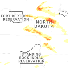


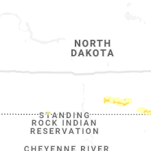


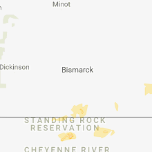


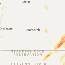


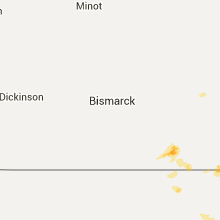


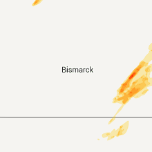


Connect with Interactive Hail Maps