

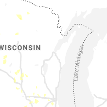
Hail Map for Friday, June 11, 2021

Number of Impacted Households on 6/11/2021
0
Impacted by 1" or Larger Hail
0
Impacted by 1.75" or Larger Hail
0
Impacted by 2.5" or Larger Hail
Square Miles of Populated Area Impacted on 6/11/2021
0
Impacted by 1" or Larger Hail
0
Impacted by 1.75" or Larger Hail
0
Impacted by 2.5" or Larger Hail


Cities Most Affected by Hail Storms of 6/11/2021
| Hail Size | Demographics of Zip Codes Affected | ||||||
|---|---|---|---|---|---|---|---|
| City | Count | Average | Largest | Pop Density | House Value | Income | Age |
| Arkansas City, KS | 3 | 2.00 | 2.50 | 106 | $48k | $31.3k | 36.8 |
| Auburn, NE | 1 | 2.00 | 2.00 | 31 | $66k | $35.2k | 42.9 |
| Saint Joseph, MO | 1 | 2.00 | 2.00 | 302 | $71k | $37.7k | 38.3 |
| Benton, KS | 1 | 1.75 | 1.75 | 25 | $82k | $50.1k | 39.7 |
| Tecumseh, NE | 1 | 1.75 | 1.75 | 14 | $53k | $31.1k | 41.1 |
Hail and Wind Damage Spotted on 6/11/2021
Filter by Report Type:Hail ReportsWind Reports
States Impacted
Minnesota, Iowa, Nebraska, Wisconsin, North Carolina, Kansas, Missouri, Michigan, Illinois, Georgia, Virginia, North Dakota, Kentucky, South Carolina, Arkansas, Oklahoma, TexasMinnesota
| Local Time | Report Details |
|---|---|
| 7:50 AM CDT | Mesonet station mn007 i-90 mile post 3 in nobles county MN, 48.7 miles E of Sioux Falls, SD |
| 9:44 AM CDT | Quarter sized hail reported near Saginaw, MN, 18.1 miles WNW of Duluth, MN, cocorahs observer mn-sl-82. |
| 9:46 AM CDT | Half Dollar sized hail reported near Saginaw, MN, 17.6 miles WNW of Duluth, MN |
| 9:50 AM CDT | Quarter sized hail reported near Saginaw, MN, 18.1 miles WNW of Duluth, MN, mping report on highway 2 just west of highway 33. |
| 11:30 AM CDT | Few trees down. information relayed by broadcast meteorologist. time estimated based on rada in goodhue county MN, 40.1 miles SSE of Minneapolis, MN |
| 11:35 AM CDT | Barn roof partially collapsed. portion of tin ripped off garage. time estimated based on radar. information courtesy of sogn valley skywarn facebook pag in goodhue county MN, 41.1 miles SE of Minneapolis, MN |
| 11:50 AM CDT | Numerous trees down across red wing and just outside the city. trees are down on houses and vehicles. some power lines also dow in goodhue county MN, 45.9 miles SE of Minneapolis, MN |
| 11:53 AM CDT | Nine inch branches down and shingles torn off per trained spotter. another report nearby mentioned siding off a building in red win in goodhue county MN, 45.9 miles SE of Minneapolis, MN |
Iowa
| Local Time | Report Details |
|---|---|
| 8:05 AM CDT | 3 tree limbs cracked and broken. winds estimated 50 to 60 mp in harrison county IA, 39.7 miles N of Omaha, NE |
| 8:59 AM CDT | Asos station kest estherville airpor in emmet county IA, 56.8 miles NNE of Storm Lake, IA |
| 9:00 AM CDT | Large tree limb on us 30... blocking the roa in harrison county IA, 44.3 miles NNE of Omaha, NE |
| 2:32 PM CDT | Roof damage to the church across the street from the fire statio in des moines county IA, 39.5 miles NE of Kahoka, MO |
| 2:32 PM CDT | Partial wooden fence collapse at menards in west burlingto in des moines county IA, 39.1 miles NE of Kahoka, MO |
| 2:33 PM CDT | Corrects time of previous tstm wnd dmg report from burlington. large garage door blown in at a factor in des moines county IA, 41.4 miles NE of Kahoka, MO |
| 2:34 PM CDT | Partial wall collapse at a small business on east agency rd in west burlingto in des moines county IA, 40.2 miles NE of Kahoka, MO |
| 2:37 PM CDT | Large tree limb down at notre dame high schoo in des moines county IA, 40.2 miles NE of Kahoka, MO |
| 2:42 PM CDT | Part of a tree down in crapo par in des moines county IA, 40.9 miles NE of Kahoka, MO |
| 2:43 PM CDT | Large tree limb down on a hous in des moines county IA, 41.4 miles NE of Kahoka, MO |
| 2:48 PM CDT | Large garage door blown in at a factor in des moines county IA, 41.4 miles NE of Kahoka, MO |
Nebraska
| Local Time | Report Details |
|---|---|
| 8:05 AM CDT | Large trash dumpster blown over. shutters blown off home. winds estimated at 60 mp in platte county NE, 61.8 miles NE of Grand Island, NE |
| 8:20 AM CDT | Small tree limbs blown down. size unknow in colfax county NE, 59.7 miles WNW of Omaha, NE |
| 8:41 AM CDT | 1 inch tree limbs broke in colfax county NE, 59.7 miles WNW of Omaha, NE |
| 9:14 AM CDT | Report from mping: 1-inch tree limbs broken; shingles blown of in lancaster county NE, 41 miles WSW of Omaha, NE |
| 11:00 AM CDT | Quarter sized hail reported near Sterling, NE, 59.7 miles SSW of Omaha, NE |
| 11:07 AM CDT | Small tree limbs down. report from mpin in pawnee county NE, 72 miles N of Manhattan, KS |
| 11:25 AM CDT | Metal roof on large farm outbuilding peeled back. received on social media. time estimate in johnson county NE, 61.3 miles SSW of Omaha, NE |
| 11:39 AM CDT | Quarter sized hail reported near Auburn, NE, 60.2 miles S of Omaha, NE |
| 11:40 AM CDT | Golf Ball sized hail reported near Tecumseh, NE, 61.7 miles S of Omaha, NE, mping report. |
| 11:47 AM CDT | Quarter sized hail reported near Johnson, NE, 58.8 miles S of Omaha, NE |
| 12:07 PM CDT | Hen Egg sized hail reported near Auburn, NE, 61.7 miles S of Omaha, NE, hail larger than a golf ball but smaller than a tennis ball. |
| 12:14 PM CDT | Ping Pong Ball sized hail reported near Auburn, NE, 63 miles S of Omaha, NE |
| 12:22 PM CDT | Corrects previous tstm wnd dmg report from du bois. trees down in du bois with report of trees down along hwy 50 north of tow in pawnee county NE, 65.6 miles NNE of Manhattan, KS |
Wisconsin
| Local Time | Report Details |
|---|---|
| 9:47 AM CDT | Quarter sized hail reported near Superior, WI, 5.4 miles S of Duluth, MN |
| 9:50 AM CDT | Quarter sized hail reported near Superior, WI, 16.5 miles S of Duluth, MN, cocorahs observer. |
| 9:55 AM CDT | Quarter sized hail reported near Superior, WI, 14.4 miles S of Duluth, MN |
| 11:55 AM CDT | Measured at red wing airpor in pierce county WI, 46.6 miles SE of Minneapolis, MN |
| 12:30 PM CDT | Fourteen inch diameter tree down over house. report relayed by amateur radio operato in pierce county WI, 56.4 miles ESE of Minneapolis, MN |
| 12:35 PM CDT | Ten inch diameter trees down. report relayed by amateur radio operato in dunn county WI, 59.6 miles ESE of Minneapolis, MN |
| 12:45 PM CDT | 3-4 ft diameter tree uprooted. time estimated via rada in dunn county WI, 65.9 miles E of Minneapolis, MN |
| 12:50 PM CDT | Scattered trees and power lines down in and south of menomonie per dispatch. a street light was also down. one tree was uprooted and against an apartment building near in dunn county WI, 65.4 miles E of Minneapolis, MN |
| 1:58 PM CDT | Large trees down/snapped... pictures on twitter. time estimated via rada in chippewa county WI, 87.7 miles WSW of Rhinelander, WI |
| 3:00 PM CDT | Two tree limbs down. time estimated from rada in sauk county WI, 33.3 miles NW of Madison, WI |
| 5:25 PM CDT | Quarter sized hail reported near Drummond, WI, 55.4 miles SE of Duluth, MN, half inch to one inch size hail fell for about fifteen minutes. report and picture received via facebook. |
North Carolina
| Local Time | Report Details |
|---|---|
| 12:56 PM EDT | Sheriff reports tree down along sloans mill road. time estimated from rada in yadkin county NC, 59.8 miles N of Charlotte, NC |
| 2:02 PM EDT | Tree reported down at 1700 block of harrington highwa in rockingham county NC, 56.8 miles S of Roanoke, VA |
Kansas
| Local Time | Report Details |
|---|---|
| 12:15 PM CDT | Gust front winds ahead of storm in nemaha county KS, 55.8 miles NE of Manhattan, KS |
| 12:31 PM CDT | Tree damage in town. power poles snapped around ber in nemaha county KS, 62.5 miles NNE of Manhattan, KS |
| 12:46 PM CDT | Time estimated by rada in brown county KS, 65 miles NE of Manhattan, KS |
| 12:46 PM CDT | Trees reported to have fallen on house. time estimated by rada in nemaha county KS, 64.3 miles NE of Manhattan, KS |
| 12:46 PM CDT | Report of aircraft overturned... and damage to aircraft hanger. time estimated by rada in brown county KS, 65.5 miles NE of Manhattan, KS |
| 1:05 PM CDT | Report of house blown off foundation. time estimated by rada in brown county KS, 63.7 miles NE of Manhattan, KS |
| 1:17 PM CDT | Trees reported down in city. time estimated by rada in brown county KS, 72 miles NE of Manhattan, KS |
| 1:33 PM CDT | Corrects previous tstm wnd dmg report from 4 s holton. tree knocked over a power line near 198th and r in jackson county KS, 47.1 miles ENE of Manhattan, KS |
| 1:44 PM CDT | Storm damage reported in jackson county KS, 46.3 miles ENE of Manhattan, KS |
| 1:48 PM CDT | Report from mping: 1-inch tree limbs broken; shingles blown of in jackson county KS, 46.5 miles ENE of Manhattan, KS |
| 1:50 PM CDT | Storm damage reported in jackson county KS, 45.5 miles E of Manhattan, KS |
| 1:54 PM CDT | Report from mping: 1-inch tree limbs broken; shingles blown of in jackson county KS, 46 miles E of Manhattan, KS |
| 1:58 PM CDT | Report from mping: 3-inch tree limbs broken; power poles broke in jefferson county KS, 50.5 miles WNW of Kansas City, MO |
| 2:00 PM CDT | Storm damage reported in jefferson county KS, 50.3 miles WNW of Kansas City, MO |
| 2:01 PM CDT | 134th and kin in jefferson county KS, 47.9 miles W of Kansas City, MO |
| 2:13 PM CDT | Quarter sized hail reported near Valley Falls, KS, 51.8 miles WNW of Kansas City, MO |
| 2:13 PM CDT | Storm damage reported in jefferson county KS, 53.3 miles E of Manhattan, KS |
| 2:15 PM CDT | Storm damage reported in jefferson county KS, 52.7 miles E of Manhattan, KS |
| 2:21 PM CDT | Storm damage reported in jefferson county KS, 39.8 miles WNW of Kansas City, MO |
| 2:23 PM CDT | Tree knocked over a power line near 198th and r in jackson county KS, 47.1 miles ENE of Manhattan, KS |
| 2:25 PM CDT | Corrects previous tstm wnd gst report from wincheste in jefferson county KS, 39.8 miles WNW of Kansas City, MO |
| 2:30 PM CDT | Storm damage reported in jefferson county KS, 52 miles W of Kansas City, MO |
| 2:35 PM CDT | Tree damag in shawnee county KS, 53.2 miles W of Kansas City, MO |
| 2:41 PM CDT | Report from mping: 3-inch tree limbs broken; power poles broke in shawnee county KS, 51.6 miles W of Kansas City, MO |
| 2:51 PM CDT | Trees down. all trees were dead with diameters approximately 20 inche in leavenworth county KS, 26.2 miles WNW of Kansas City, MO |
| 3:11 PM CDT | Delayed report. numerous photos of snapped trees in areas just west of piper high schoo in wyandotte county KS, 15.6 miles WNW of Kansas City, MO |
| 3:19 PM CDT | Tree dow in douglas county KS, 41.2 miles WSW of Kansas City, MO |
| 3:22 PM CDT | 6 inch large tree branch dow in johnson county KS, 8.9 miles SW of Kansas City, MO |
| 3:30 PM CDT | Tree on power lines and 3 power poles dow in leavenworth county KS, 18.3 miles W of Kansas City, MO |
| 3:38 PM CDT | Delayed report. several 6 to 12 inch trees down near the intersection of 159th and quivira in olathe. time estimated from rada in johnson county KS, 19.6 miles SSW of Kansas City, MO |
| 3:40 PM CDT | Delayed report. ten inch tree limbs down in roeland par in johnson county KS, 5 miles SSW of Kansas City, MO |
| 3:45 PM CDT | Motorist hit down power line in roadway in area of 153 terr/parallel road (basehor... ks in leavenworth county KS, 19.3 miles W of Kansas City, MO |
| 3:48 PM CDT | Ping Pong Ball sized hail reported near Leawood, KS, 11.3 miles S of Kansas City, MO, delayed report. 435 and stateline. |
| 3:54 PM CDT | Storm damage reported in jefferson county KS, 39.8 miles WNW of Kansas City, MO |
| 4:00 PM CDT | Quarter sized hail reported near Leawood, KS, 12.6 miles SSW of Kansas City, MO, several reports of quarter sized-hail. pictures on twitter shows hail appropriately measured. |
| 4:02 PM CDT | Ping Pong Ball sized hail reported near Leawood, KS, 13.3 miles SSW of Kansas City, MO |
| 4:02 PM CDT | Quarter sized hail reported near Overland Park, KS, 9.1 miles SSW of Kansas City, MO, delayed report. |
| 4:21 PM CDT | Pomona lake marina reported via facebook severe storm damage to the store... docks... and walkways... as well as damage to several boats. time estimated by rada in osage county KS, 62.3 miles WSW of Kansas City, MO |
| 4:22 PM CDT | Storm damage reported in osage county KS, 57.1 miles WSW of Kansas City, MO |
| 4:25 PM CDT | Storm damage reported in osage county KS, 57.7 miles WSW of Kansas City, MO |
| 5:05 PM CDT | Storm damage reported in franklin county KS, 50.7 miles NNE of Chanute, KS |
| 5:15 PM CDT | Public report of t-storm wind gusts of around 70 mp in anderson county KS, 42.8 miles NNE of Chanute, KS |
| 5:23 PM CDT | Damage to windows and trees. 6 inch diameter tree snappe in anderson county KS, 49.5 miles NNE of Chanute, KS |
| 5:25 PM CDT | Estimated 90-100 mph wind in anderson county KS, 50.6 miles NNE of Chanute, KS |
| 5:45 PM CDT | Machine shop damaged... shed totally destroye in anderson county KS, 32 miles NNE of Chanute, KS |
| 5:54 PM CDT | Large tree uprooted with numerous other reports of trees and limbs dow in allen county KS, 16.6 miles N of Chanute, KS |
| 5:56 PM CDT | Storm damage reported in linn county KS, 37.1 miles NE of Chanute, KS |
| 6:02 PM CDT | Measured at the allen county airpor in allen county KS, 13.4 miles NNE of Chanute, KS |
| 6:15 PM CDT | Ksu mesonet sit in bourbon county KS, 27.5 miles ENE of Chanute, KS |
| 6:30 PM CDT | Corrects previous tstm wnd gst report from 1 sw uniontown. ksu mesonet site measured at 10 in bourbon county KS, 27.5 miles ENE of Chanute, KS |
| 6:54 PM CDT | 660 and 3 hwy... large tree over the highway blocking both lanes in crawford county. time based on radar estimat in crawford county KS, 28.1 miles ESE of Chanute, KS |
| 7:05 PM CDT | Storm damage reported in neosho county KS, 13.9 miles SE of Chanute, KS |
| 7:05 PM CDT | Power lines down girard... ks. time based on rada in crawford county KS, 35.6 miles ESE of Chanute, KS |
| 7:05 PM CDT | Power lines down starting fire 680th and 130th crawford county k in crawford county KS, 32.4 miles E of Chanute, KS |
| 7:25 PM CDT | Large tree down pittsburg... ks. time based on rada in crawford county KS, 45.3 miles ESE of Chanute, KS |
| 7:26 PM CDT | 520 and 200 ave in crawford county... tree down on powerlines. time based on rada in crawford county KS, 44.6 miles ESE of Chanute, KS |
| 7:38 PM CDT | 3 ft diameter silver maple uprooted blocking 126 hwy 2 mi west of pittsburg. time based on rada in crawford county KS, 43.4 miles ESE of Chanute, KS |
| 7:38 PM CDT | Numerous small limbs up to 4 inches in diameter down in chicopee. time based on rada in crawford county KS, 44.3 miles ESE of Chanute, KS |
| 7:47 PM CDT | Corrects previous tstm wnd gst report from 3 n crestline. easily winds at 65-70mph... zero visibility.down power lines... lots of limbs dow in cherokee county KS, 52.2 miles SE of Chanute, KS |
| 8:33 PM CDT | Storm damage reported in butler county KS, 14.3 miles ENE of Wichita, KS |
| 8:45 PM CDT | 5 inch diameter tree limbs dow in butler county KS, 13.9 miles ENE of Wichita, KS |
| 8:51 PM CDT | Utility pole dow in butler county KS, 14.6 miles ENE of Wichita, KS |
| 9:00 PM CDT | Golf Ball sized hail reported near Benton, KS, 14.3 miles ENE of Wichita, KS, delayed report. |
| 9:19 PM CDT | Power lines downe in butler county KS, 11 miles ESE of Wichita, KS |
| 10:00 PM CDT | 60 knot wind measured at strother fiel in cowley county KS, 39.2 miles SSE of Wichita, KS |
| 10:17 PM CDT | Storm damage reported in cowley county KS, 43.6 miles SSE of Wichita, KS |
| 10:26 PM CDT | Golf Ball sized hail reported near Arkansas City, KS, 46.2 miles SSE of Wichita, KS |
| 10:29 PM CDT | 10 inch diameter tree limb down just south of madison on summit stree in cowley county KS, 46.2 miles SSE of Wichita, KS |
| 10:29 PM CDT | Golf Ball sized hail reported near Arkansas City, KS, 45.6 miles SSE of Wichita, KS |
| 10:33 PM CDT | Tennis Ball sized hail reported near Arkansas City, KS, 47 miles SSE of Wichita, KS |
| 10:36 PM CDT | Quarter sized hail reported near Arkansas City, KS, 45.6 miles SSE of Wichita, KS, measured 57 mph winds with small branches down. |
| 10:40 PM CDT | Storm damage reported in cowley county KS, 45.6 miles SSE of Wichita, KS |
Missouri
| Local Time | Report Details |
|---|---|
| 2:20 PM CDT | Trees and branches 6 inches in diameter down. 1.75 inches of rai in buchanan county MO, 48.3 miles NNW of Kansas City, MO |
| 2:36 PM CDT | Hen Egg sized hail reported near Saint Joseph, MO, 53.6 miles NNW of Kansas City, MO |
| 2:38 PM CDT | Storm damage reported in buchanan county MO, 49.2 miles NNW of Kansas City, MO |
| 2:45 PM CDT | 2 inch diameter tree dow in andrew county MO, 56.1 miles NNW of Kansas City, MO |
| 3:00 PM CDT | Power poles down in gower... mo and on j hwy at middle roa in clinton county MO, 35 miles N of Kansas City, MO |
| 3:15 PM CDT | Delayed report. ten inch tree limbs dow in clay county MO, 19.8 miles N of Kansas City, MO |
| 3:23 PM CDT | Several large oak tree limbs down. owner estimated 70 to 80 mp in clinton county MO, 33.8 miles NNE of Kansas City, MO |
| 3:27 PM CDT | Multiple 1 foot in diameter trees down in between kearney... mo and excelsior springs... mo. trees were reported healthy with numerous reported down. debris on ground a in clay county MO, 24.1 miles NE of Kansas City, MO |
| 3:30 PM CDT | 40-60 trees down... both healthy and dead trees. 2 foot diameter trees down. a few houses have fallen trees on them... power lines dow in clay county MO, 25 miles NE of Kansas City, MO |
| 3:30 PM CDT | Winds knocked down street lamps... several 2-2.5 inch tree branches on roadways. sporadic pea-sized hail reporte in clay county MO, 27.3 miles NNE of Kansas City, MO |
| 3:30 PM CDT | Up to 100 trees down from straight-line winds... tree diameter ranging from 2-3 inches to 3 feet. damage to siding... fencing... with cars reported damaged from tree de in clay county MO, 25.9 miles NE of Kansas City, MO |
| 3:30 PM CDT | Delayed report. at watkins mill state park there were approximately 25 to 30 trees down across the campground with trees on top of cars and campers. as of the report ti in clay county MO, 26.8 miles NE of Kansas City, MO |
| 3:30 PM CDT | Delayed report. 10 inch tree limb down in lathro in clinton county MO, 33.7 miles NNE of Kansas City, MO |
| 3:33 PM CDT | Estimated 60mph 33 hwy one half mile east of 92 clay count in clay county MO, 22.3 miles NNE of Kansas City, MO |
| 3:38 PM CDT | Delayed report. two foot diameter tree uproote in clay county MO, 25 miles NE of Kansas City, MO |
| 3:45 PM CDT | Delayed report. one foot diameter tree uprooted... with several large limbs also broke in ray county MO, 27.5 miles NE of Kansas City, MO |
| 3:46 PM CDT | Delayed report. ten inch tree limbs down in brooksid in jackson county MO, 5.7 miles S of Kansas City, MO |
| 3:49 PM CDT | Delayed report. estimated 65 to 70 mph winds in independenc in jackson county MO, 8.8 miles E of Kansas City, MO |
| 3:58 PM CDT | Delayed report. ten inch tree limbs down in grain valle in jackson county MO, 21.4 miles ESE of Kansas City, MO |
| 4:00 PM CDT | Small tree debris on groun in jackson county MO, 18.1 miles SE of Kansas City, MO |
| 4:00 PM CDT | Storm damage reported in clay county MO, 21.7 miles NE of Kansas City, MO |
| 4:05 PM CDT | Social media report... no major damage... sporadic power outage in jackson county MO, 9.3 miles E of Kansas City, MO |
| 4:10 PM CDT | Storm damage reported in cass county MO, 19.7 miles SSE of Kansas City, MO |
| 4:30 PM CDT | Report of roof damage to church. media video showed large section of roof blown off. time estimated via rada in cass county MO, 33.7 miles SSE of Kansas City, MO |
| 5:08 PM CDT | Delayed report. estimated 60 to 65 mph wind in green ridg in pettis county MO, 62.4 miles WSW of Columbia, MO |
| 5:09 PM CDT | Storm damage reported in johnson county MO, 49.8 miles ESE of Kansas City, MO |
| 5:20 PM CDT | Small and larger tree branches down along with 1 to 2 foot trees down. power poles are bent and some siding off of houses. estimated winds of 60 to 70 mph lasted about in benton county MO, 61.7 miles WSW of Columbia, MO |
| 5:30 PM CDT | Delayed report. tree blown down onto garage near mcpherson and grant. time estimate in johnson county MO, 60.5 miles ESE of Kansas City, MO |
| 5:33 PM CDT | Storm damage reported in johnson county MO, 60.8 miles ESE of Kansas City, MO |
| 5:33 PM CDT | Corrects previous tstm wnd gst report from 3 wnw cole camp. mesonet station fw3737 cole camp. wind is from 332 degree in benton county MO, 59.2 miles WSW of Columbia, MO |
| 5:34 PM CDT | Storm damage reported in pettis county MO, 49.9 miles WSW of Columbia, MO |
| 5:49 PM CDT | Wind gust of 59 mph. wind is from 360 degrees. warsaw municipal airpor in benton county MO, 68.9 miles SW of Columbia, MO |
| 6:00 PM CDT | Half Dollar sized hail reported near Warsaw, MO, 71.9 miles N of Springfield, MO, time estimated via radar. report via social media. |
| 6:15 PM CDT | Numerous outages in northwestern camden county per electric coo in camden county MO, 63.6 miles SW of Columbia, MO |
| 6:30 PM CDT | Power lines down on hwy d between preston and nemo. time based on rada in hickory county MO, 48.5 miles N of Springfield, MO |
| 6:30 PM CDT | Power lines down in hermitag in hickory county MO, 50.4 miles N of Springfield, MO |
| 6:44 PM CDT | Quarter sized hail reported near Macks Creek, MO, 55.4 miles NNE of Springfield, MO |
| 6:45 PM CDT | Six large trees downe in dallas county MO, 38.8 miles NNE of Springfield, MO |
| 6:51 PM CDT | Trees down on dude ranch rd and ledges dr. in osage beac in camden county MO, 58.9 miles SSW of Columbia, MO |
| 7:02 PM CDT | Quarter sized hail reported near Osage Beach, MO, 57.5 miles SSW of Columbia, MO |
| 7:20 PM CDT | Several outages due to limbs on line in polk county MO, 17.6 miles N of Springfield, MO |
| 7:35 PM CDT | Heavy winds blowing younger 1-2 ft trees over... and moving garage door in the trac in greene county MO, 9.7 miles N of Springfield, MO |
| 7:35 PM CDT | Tree uprooted by the gust front on farm road 146 near wilsons creek. time based on rada in greene county MO, 3 miles WSW of Springfield, MO |
| 7:54 PM CDT | Report of a big tree down on fir/cr 300 in jasper county. time based on rada in jasper county MO, 59.5 miles SE of Chanute, KS |
| 8:00 PM CDT | 2 inch limbs down in seymour just south of mcdonalds. time based on rada in webster county MO, 29.1 miles E of Springfield, MO |
| 8:20 PM CDT | Limbs down and damage to out buildings in the goodhope area. time based on rada in douglas county MO, 33.7 miles SE of Springfield, MO |
| 8:40 PM CDT | Numerous reports of outages due to tree limbs from southwest douglas county into northwestern ozark county per electric compan in ozark county MO, 42.8 miles SE of Springfield, MO |
| 8:44 PM CDT | Whole tree down on jj between hwy 5 and thornfield... completely blocking road. another tree down on 95 between thornfield and hwy 5... partly blocking 9 in ozark county MO, 49 miles SE of Springfield, MO |
| 9:04 PM CDT | Deputy reporting trees and telephone lines down in theodosia on hwy 160. time based on rada in ozark county MO, 55 miles SE of Springfield, MO |
| 9:10 PM CDT | Several hundred outages due to storms per electric coo in ozark county MO, 61.2 miles SE of Springfield, MO |
| 9:14 PM CDT | Tree down blocking hwy aa 2 miles from hwy 181. time based on rada in ozark county MO, 63.5 miles SE of Springfield, MO |
| 9:19 PM CDT | 2 trees down on hwy o between udall and bakersfield near county road 551. one completely blocking. time based on rada in ozark county MO, 74.3 miles SE of Springfield, MO |
| 9:25 PM CDT | Tree down with a power line on farm road 1107 near the crossing with sale barn road near cassvill in barry county MO, 49.4 miles SW of Springfield, MO |
| 9:25 PM CDT | Had reports of a tree across hwy pp between james bridge and hwy 160. local fire remove in ozark county MO, 70 miles SE of Springfield, MO |
Michigan
| Local Time | Report Details |
|---|---|
| 3:39 PM EDT | County dispatch reported trees down across gladwin county with buckeye township and billings township the hardest hit. time estimated from rada in gladwin county MI, 74.3 miles NNW of Flint, MI |
| 3:50 PM EDT | Multiple trees dow in clare county MI, 67.5 miles SE of Traverse City, MI |
| 4:10 PM EDT | Several trees down on middle rd reported by bait shop employe in gladwin county MI, 65.2 miles NNW of Flint, MI |
| 4:25 PM EDT | Multiple trees dow in clare county MI, 72.8 miles NNE of Grand Rapids, MI |
| 6:00 PM EDT | Multiple trees down. time estimated based on rada in ionia county MI, 37.1 miles E of Grand Rapids, MI |
| 8:35 PM EDT | Corrects previous non-tstm wnd gst report from 2 sw fishers lake. awos station khai three river in st. joseph county MI, 67 miles NNW of Fort Wayne, IN |
Illinois
| Local Time | Report Details |
|---|---|
| 3:26 PM CDT | A 2 foot in diameter tree was blown down and is now blocking a road 1 mile south of highway 72. the tree appeared to be rotten in the middle. time estimated by rada in ogle county IL, 70.2 miles SSE of Madison, WI |
| 3:26 PM CDT | Roughly eight mile swath of tree damage in and around lindenwood... with multiple photos of large and healthy trees snapped half way up the trunk. a large outbuilding w in ogle county IL, 72.9 miles W of Chicago, IL |
| 3:27 PM CDT | An approximately 60 ft comms tower was blown down. time estimated by rada in ogle county IL, 72.9 miles W of Chicago, IL |
| 3:52 PM CDT | Power poles leaned over and wires downed due to the wind. time estimated by rada in de kalb county IL, 63.4 miles W of Chicago, IL |
Georgia
| Local Time | Report Details |
|---|---|
| 4:33 PM EDT | A couple of trees were reported down in the double churches road and river road are in muscogee county GA, 28.4 miles E of Auburn, AL |
Virginia
| Local Time | Report Details |
|---|---|
| 4:35 PM EDT | A few trees on a power line near the intersection of indian hill road and evergree road in the northern part of lynchburg cit in city of lynchburg county VA, 41.7 miles ENE of Roanoke, VA |
| 6:30 PM EDT | Tree down near arvonia on bridgeport roa in buckingham county VA, 39.9 miles WNW of Richmond, VA |
North Dakota
| Local Time | Report Details |
|---|---|
| 3:57 PM CDT | Peak wind report at 10 meter ndawn senso in nelson county ND, 33.2 miles SE of Devils Lake, ND |
Kentucky
| Local Time | Report Details |
|---|---|
| 6:00 PM EDT | Social media photos of damaged metal shed blown from owners property. time estimated from rada in jefferson county KY, 14.5 miles NNW of Louisville, KY |
| 6:01 PM EDT | Tree down grandel farms. time estimated from rada in jefferson county KY, 14.2 miles NNW of Louisville, KY |
| 6:01 PM EDT | Tree limb down on strive ln. time estimated from rada in jefferson county KY, 13.6 miles NW of Louisville, KY |
| 6:25 PM EDT | Trees down along blevins gap road between valley station and fairdal in jefferson county KY, 8.9 miles NW of Louisville, KY |
| 6:31 PM EDT | Kfft asos reported a 57 knot wind gust at 631 pm ed in franklin county KY, 45.9 miles ENE of Louisville, KY |
| 6:43 PM EDT | Trees down in power lines with power lines sparking. video provided via twitte in anderson county KY, 44.7 miles E of Louisville, KY |
| 7:03 PM EDT | Emergency management reported minor damage to an outbuilding and nearby trees in the may hollow area east of tollesboro ky. possible weak tornado. no other damage repor in lewis county KY, 64.5 miles NNE of Irvine, KY |
| 8:04 PM EDT | Power lines down in upto in hardin county KY, 37.9 miles SSW of Louisville, KY |
| 7:09 PM CDT | Trees down blocking 31w just north of bonnieville. also several reports of barns damaged by wind. time based on radar dat in hart county KY, 41.8 miles SSW of Louisville, KY |
South Carolina
| Local Time | Report Details |
|---|---|
| 7:30 PM EDT | A tree blown down onto power lines on north oakland street. power outages across the neighborhoo in spartanburg county SC, 47.3 miles ENE of Greenville, SC |
| 7:30 PM EDT | A tree blown down onto power lines on north oakland street. power outages across the neighborhoo in spartanburg county SC, 47.3 miles ENE of Greenville, SC |
Arkansas
| Local Time | Report Details |
|---|---|
| 9:17 PM CDT | Trees were blown down on the east side of mountain hom in baxter county AR, 80.1 miles SE of Springfield, MO |
| 9:42 PM CDT | Multiple trees were blown down in the sycamore springs neighborhoo in baxter county AR, 85.3 miles SE of Springfield, MO |
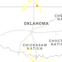
Oklahoma
| Local Time | Report Details |
|---|---|
| 10:55 PM CDT | Storm damage reported in kay county OK, 64.6 miles S of Wichita, KS |
| 11:00 PM CDT | Storm damage reported in kay county OK, 60.4 miles SSE of Wichita, KS |
| 11:46 PM CDT | Storm damage reported in osage county OK, 56.7 miles NW of Tulsa, OK |
| 2:00 AM CDT | Power lines down. time is radar estimate in oklahoma county OK, 14.6 miles ENE of Oklahoma City, OK |
| 2:00 AM CDT | Power lines down in several locations... time is radar estimate in oklahoma county OK, 7.4 miles E of Oklahoma City, OK |
| 2:30 AM CDT | Storm damage reported in grady county OK, 29.6 miles SW of Oklahoma City, OK |
| 2:35 AM CDT | Storm damage reported in grady county OK, 38.4 miles SW of Oklahoma City, OK |
| 2:35 AM CDT | Power pole and lines down. time is radar estimate in grady county OK, 18.5 miles SW of Oklahoma City, OK |
| 2:40 AM CDT | Storm damage reported in grady county OK, 39.7 miles SW of Oklahoma City, OK |
| 2:40 AM CDT | Storm damage reported in grady county OK, 54.3 miles SSW of Oklahoma City, OK |
| 2:45 AM CDT | Storm damage reported in grady county OK, 54.3 miles SSW of Oklahoma City, OK |
| 3:30 AM CDT | Storm damage reported in stephens county OK, 60.7 miles NE of Wichita Falls, TX |
| 3:35 AM CDT | Storm damage reported in stephens county OK, 60.7 miles NE of Wichita Falls, TX |
| 3:43 AM CDT | Storm damage reported in pontotoc county OK, 41.1 miles NW of Atoka, OK |
| 4:20 AM CDT | Storm damage reported in jefferson county OK, 55.8 miles ENE of Wichita Falls, TX |
Texas
| Local Time | Report Details |
|---|---|
| 5:18 AM CDT | 61 mph measured on home anemomete in montague county TX, 45.1 miles ESE of Wichita Falls, TX |
Connect with Interactive Hail Maps