

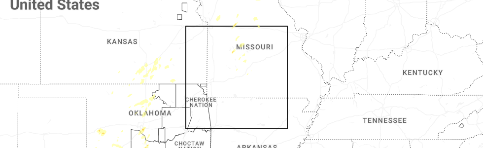
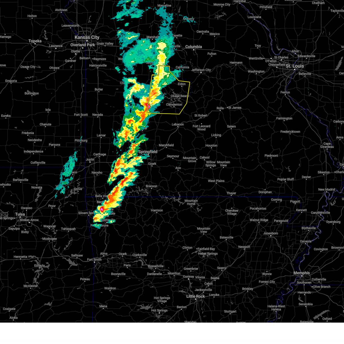
Hail Map for Macks Creek, MO
The Macks Creek, MO area has had 9 reports of on-the-ground hail by trained spotters, and has been under severe weather warnings 18 times during the past 12 months. Doppler radar has detected hail at or near Macks Creek, MO on 61 occasions, including 2 occasions during the past year.
| Name: | Macks Creek, MO |
| Where Located: | 55.1 miles NNE of Springfield, MO |
| Map: | Google Map for Macks Creek, MO |
| Population: | 244 |
| Housing Units: | 132 |
| More Info: | Search Google for Macks Creek, MO |
0
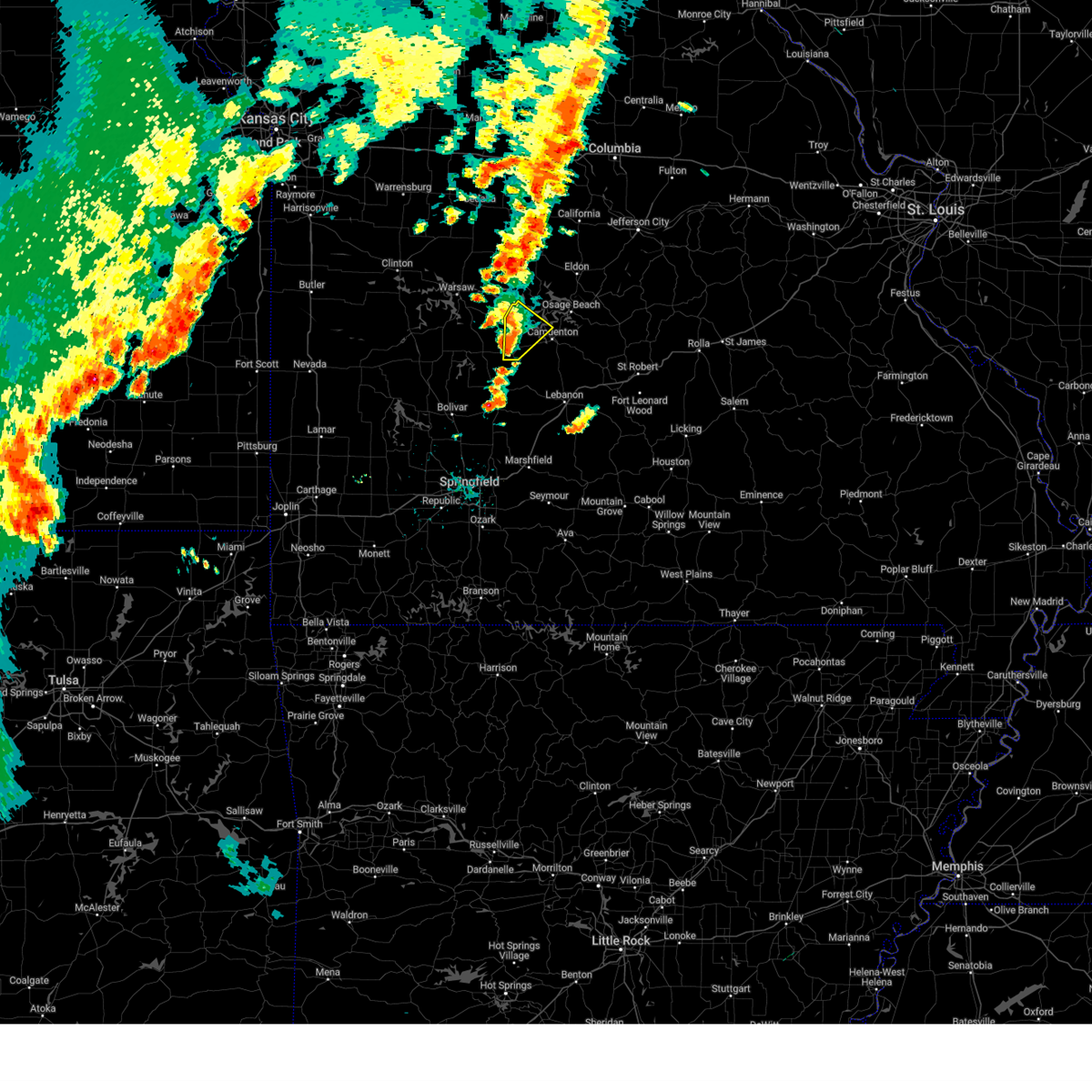
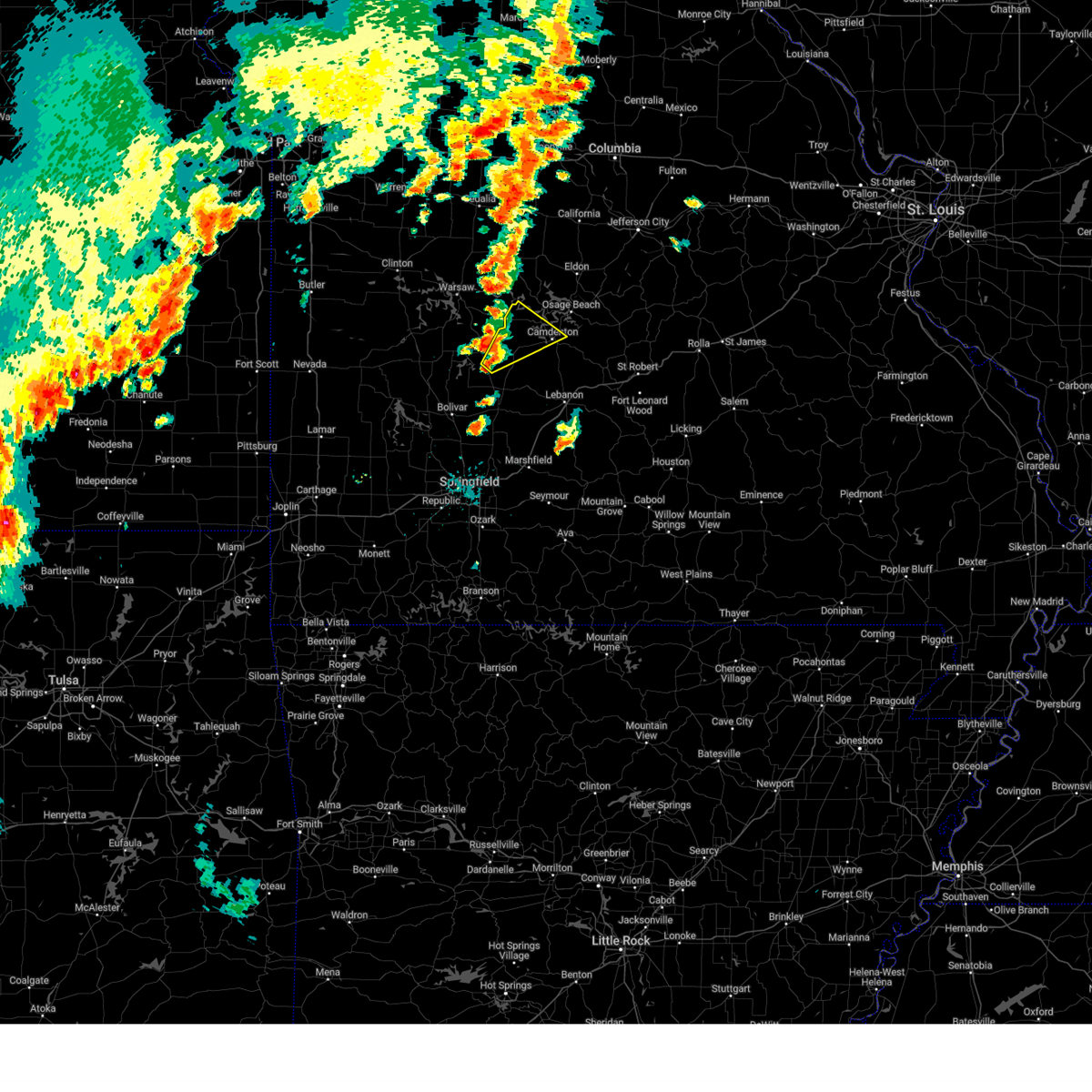
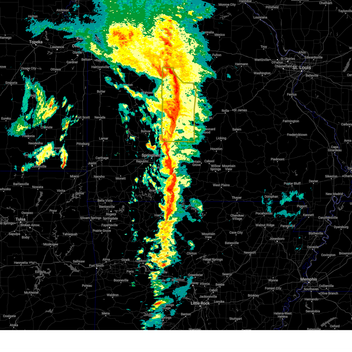
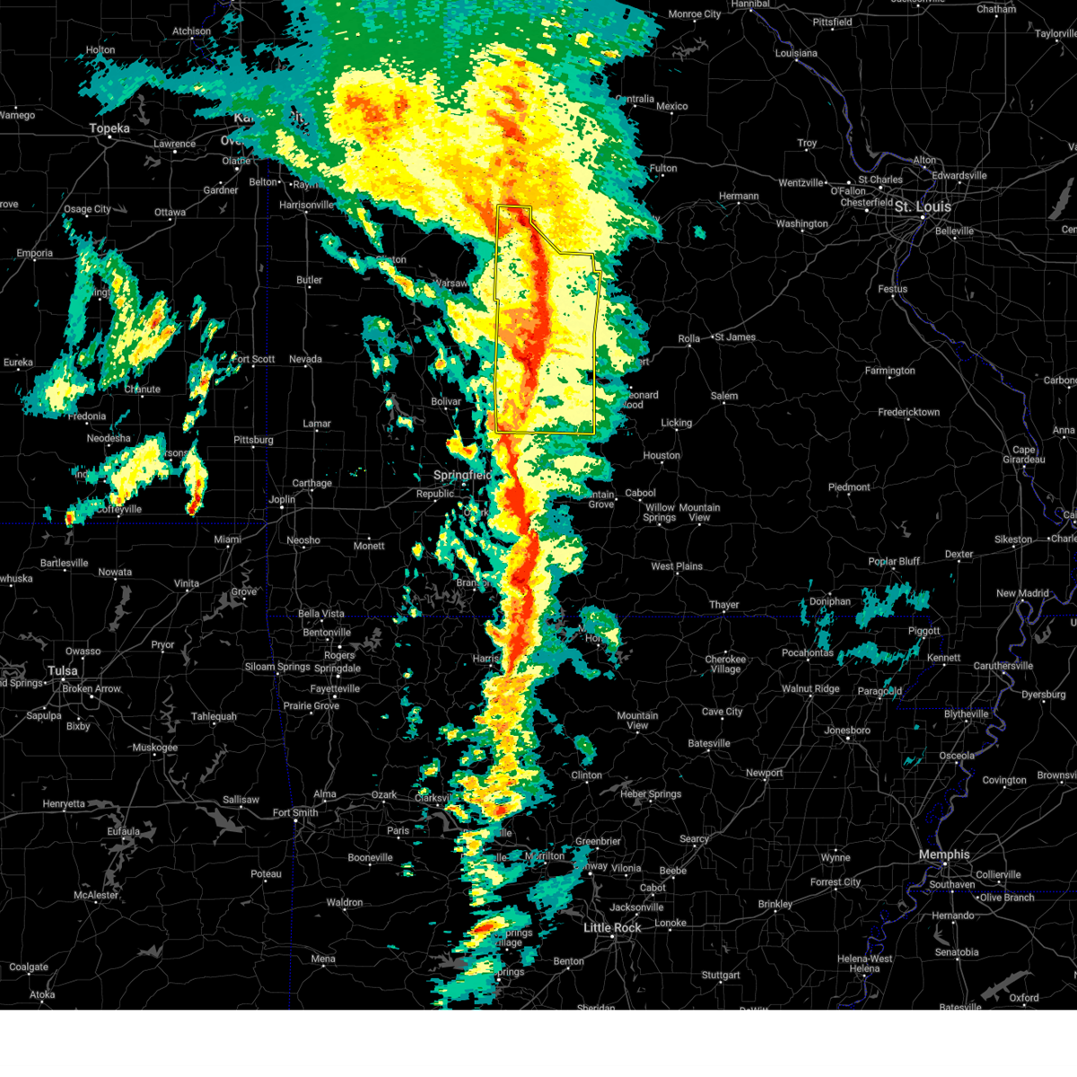
The Top Recent Hail Date for Macks Creek, MO is Tuesday, June 3, 2025 (53rd out of 61)
Hail and Wind Damage Spotted near Macks Creek, MO
| Date / Time | Report Details |
|---|---|
| 6/3/2025 7:53 PM CDT |
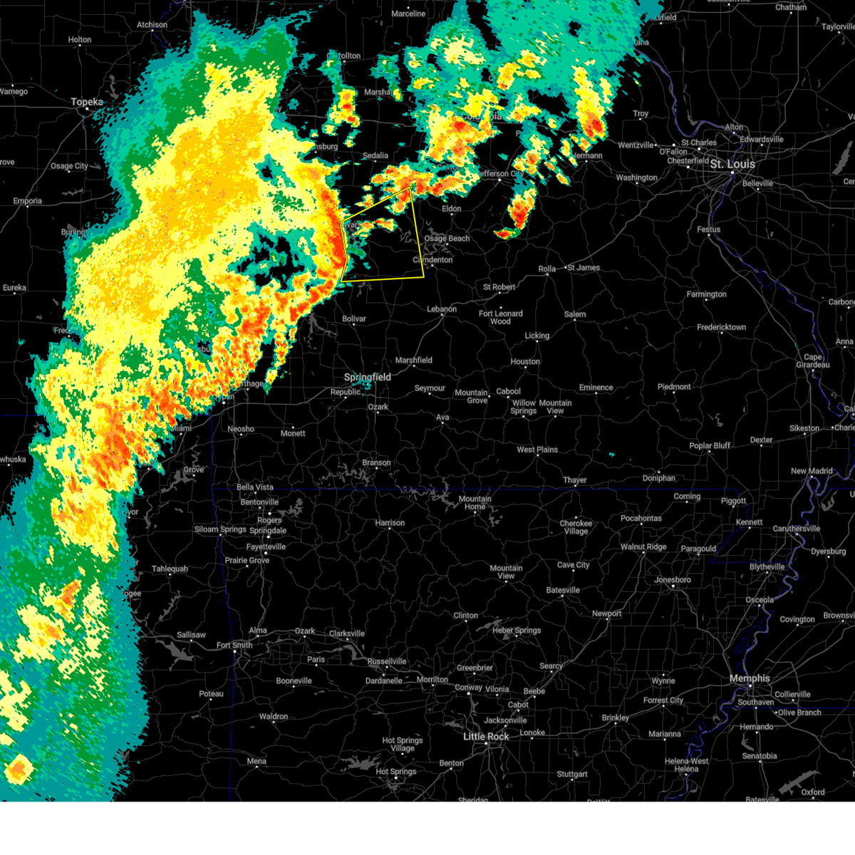 Svrsgf the national weather service in springfield has issued a * severe thunderstorm warning for, hickory county in central missouri, benton county in central missouri, northwestern camden county in central missouri, southwestern morgan county in central missouri, * until 845 pm cdt. * at 752 pm cdt, severe thunderstorms were located along a line extending from near warsaw to 9 miles northwest of hermitage to wheatland, moving east at 45 mph (radar indicated). Hazards include 60 mph wind gusts. expect damage to roofs, siding, and trees Svrsgf the national weather service in springfield has issued a * severe thunderstorm warning for, hickory county in central missouri, benton county in central missouri, northwestern camden county in central missouri, southwestern morgan county in central missouri, * until 845 pm cdt. * at 752 pm cdt, severe thunderstorms were located along a line extending from near warsaw to 9 miles northwest of hermitage to wheatland, moving east at 45 mph (radar indicated). Hazards include 60 mph wind gusts. expect damage to roofs, siding, and trees
|
| 6/3/2025 5:30 PM CDT | Svrsgf the national weather service in springfield has issued a * severe thunderstorm warning for, northeastern dallas county in southwestern missouri, northwestern laclede county in southwestern missouri, central camden county in central missouri, * until 615 pm cdt. * at 530 pm cdt, a severe thunderstorm was located 10 miles south of macks creek, or 13 miles northeast of buffalo, moving northeast at 35 mph (radar indicated). Hazards include 60 mph wind gusts and quarter size hail. Hail damage to vehicles is expected. Expect wind damage to roofs, siding, and trees. |
| 6/3/2025 5:22 PM CDT | The storm which prompted the warning has weakened below severe limits, and no longer poses an immediate threat to life or property. therefore, the warning will be allowed to expire. |
| 6/3/2025 5:03 PM CDT |
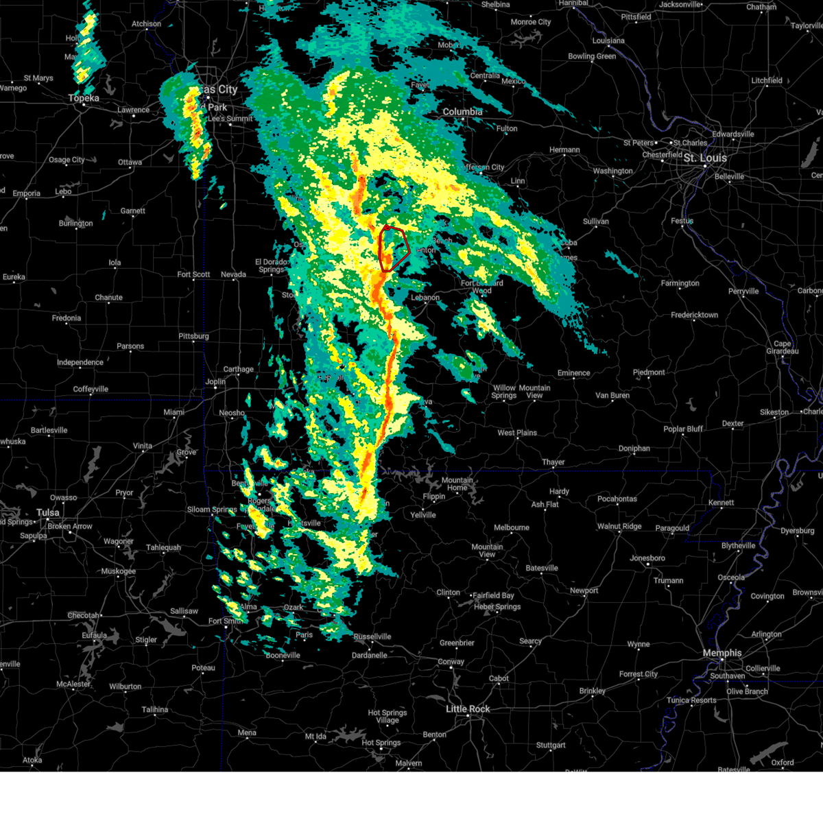
 At 503 pm cdt, a severe thunderstorm was located near macks creek, or 13 miles west of camdenton, moving northeast at 35 mph (radar indicated). Hazards include 60 mph wind gusts and quarter size hail. Hail damage to vehicles is expected. expect wind damage to roofs, siding, and trees. Locations impacted include, lake of the ozarks, macks creek, climax springs, branch, and barnumton. At 503 pm cdt, a severe thunderstorm was located near macks creek, or 13 miles west of camdenton, moving northeast at 35 mph (radar indicated). Hazards include 60 mph wind gusts and quarter size hail. Hail damage to vehicles is expected. expect wind damage to roofs, siding, and trees. Locations impacted include, lake of the ozarks, macks creek, climax springs, branch, and barnumton.
|
| 6/3/2025 5:03 PM CDT |
 the severe thunderstorm warning has been cancelled and is no longer in effect the severe thunderstorm warning has been cancelled and is no longer in effect
|
| 6/3/2025 4:53 PM CDT |
 the severe thunderstorm warning has been cancelled and is no longer in effect the severe thunderstorm warning has been cancelled and is no longer in effect
|
| 6/3/2025 4:53 PM CDT |
 At 453 pm cdt, a severe thunderstorm was located near macks creek, or 15 miles east of hermitage, moving northeast at 35 mph (radar indicated). Hazards include 60 mph wind gusts and quarter size hail. Hail damage to vehicles is expected. expect wind damage to roofs, siding, and trees. Locations impacted include, lake of the ozarks, ha ha tonka state park, camdenton, macks creek, linn creek, climax springs, branch, barnumton, roach, and old linn creek. At 453 pm cdt, a severe thunderstorm was located near macks creek, or 15 miles east of hermitage, moving northeast at 35 mph (radar indicated). Hazards include 60 mph wind gusts and quarter size hail. Hail damage to vehicles is expected. expect wind damage to roofs, siding, and trees. Locations impacted include, lake of the ozarks, ha ha tonka state park, camdenton, macks creek, linn creek, climax springs, branch, barnumton, roach, and old linn creek.
|
| 6/3/2025 4:39 PM CDT |
 Svrsgf the national weather service in springfield has issued a * severe thunderstorm warning for, eastern hickory county in central missouri, northwestern dallas county in southwestern missouri, northwestern camden county in central missouri, * until 530 pm cdt. * at 439 pm cdt, a severe thunderstorm was located near urbana, or 10 miles east of hermitage, moving northeast at 35 mph (radar indicated). Hazards include 60 mph wind gusts and quarter size hail. Hail damage to vehicles is expected. Expect wind damage to roofs, siding, and trees. Svrsgf the national weather service in springfield has issued a * severe thunderstorm warning for, eastern hickory county in central missouri, northwestern dallas county in southwestern missouri, northwestern camden county in central missouri, * until 530 pm cdt. * at 439 pm cdt, a severe thunderstorm was located near urbana, or 10 miles east of hermitage, moving northeast at 35 mph (radar indicated). Hazards include 60 mph wind gusts and quarter size hail. Hail damage to vehicles is expected. Expect wind damage to roofs, siding, and trees.
|
| 5/19/2025 7:35 PM CDT | Svrsgf the national weather service in springfield has issued a * severe thunderstorm warning for, dallas county in southwestern missouri, western laclede county in southwestern missouri, camden county in central missouri, * until 815 pm cdt. * at 735 pm cdt, severe thunderstorms were located along a line extending from near urbana to 7 miles northeast of fair grove, moving northeast at 50 mph (radar indicated). Hazards include 60 mph wind gusts. expect damage to roofs, siding, and trees |
| 4/20/2025 4:41 PM CDT |
 At 440 pm cdt, severe thunderstorms were located along a line extending from near bunceton to near village of four seasons to 10 miles west of ava, moving northeast at 55 mph (radar indicated). Hazards include 70 mph wind gusts and quarter size hail. Hail damage to vehicles is expected. expect considerable tree damage. wind damage is also likely to mobile homes, roofs, and outbuildings. locations impacted include, competition, osage beach, florence, tunas, pumpkin center, sleeper, freedom, tuscumbia, old linn creek, barnumton, linn creek, syracuse, decaturville, lake of the ozarks state park, plad, long lane, brumley, lake of the ozarks, bagnell, and eldridge. This includes interstate 44 between mile markers 110 and 144. At 440 pm cdt, severe thunderstorms were located along a line extending from near bunceton to near village of four seasons to 10 miles west of ava, moving northeast at 55 mph (radar indicated). Hazards include 70 mph wind gusts and quarter size hail. Hail damage to vehicles is expected. expect considerable tree damage. wind damage is also likely to mobile homes, roofs, and outbuildings. locations impacted include, competition, osage beach, florence, tunas, pumpkin center, sleeper, freedom, tuscumbia, old linn creek, barnumton, linn creek, syracuse, decaturville, lake of the ozarks state park, plad, long lane, brumley, lake of the ozarks, bagnell, and eldridge. This includes interstate 44 between mile markers 110 and 144.
|
| 4/20/2025 4:41 PM CDT |
 the severe thunderstorm warning has been cancelled and is no longer in effect the severe thunderstorm warning has been cancelled and is no longer in effect
|
| 4/20/2025 4:29 PM CDT | Public weather station measured 70.0 mph wind gus in dallas county MO, 5.9 miles N of Macks Creek, MO |
| 4/20/2025 3:58 PM CDT |
 Svrsgf the national weather service in springfield has issued a * severe thunderstorm warning for, eastern hickory county in central missouri, dallas county in southwestern missouri, benton county in central missouri, miller county in central missouri, eastern polk county in southwestern missouri, laclede county in southwestern missouri, camden county in central missouri, morgan county in central missouri, * until 500 pm cdt. * at 354 pm cdt, severe thunderstorms were located along a line extending from near lincoln to 10 miles northwest of buffalo to 6 miles northwest of roberson hollow, moving northeast at 55 mph (radar indicated). Hazards include 70 mph wind gusts and quarter size hail. Hail damage to vehicles is expected. expect considerable tree damage. Wind damage is also likely to mobile homes, roofs, and outbuildings. Svrsgf the national weather service in springfield has issued a * severe thunderstorm warning for, eastern hickory county in central missouri, dallas county in southwestern missouri, benton county in central missouri, miller county in central missouri, eastern polk county in southwestern missouri, laclede county in southwestern missouri, camden county in central missouri, morgan county in central missouri, * until 500 pm cdt. * at 354 pm cdt, severe thunderstorms were located along a line extending from near lincoln to 10 miles northwest of buffalo to 6 miles northwest of roberson hollow, moving northeast at 55 mph (radar indicated). Hazards include 70 mph wind gusts and quarter size hail. Hail damage to vehicles is expected. expect considerable tree damage. Wind damage is also likely to mobile homes, roofs, and outbuildings.
|
| 4/2/2025 10:00 AM CDT | At 959 am cdt, severe thunderstorms were located along a line extending from near stover to 6 miles west of laurie to near macks creek, moving northeast at 70 mph (radar indicated). Hazards include 60 mph wind gusts and quarter size hail. Hail damage to vehicles is expected. expect wind damage to roofs, siding, and trees. Locations impacted include, gravois mills, preston, leadmine, pittsburg, tunas, stover, macks creek, zora, urbana, laurie, knobby, hurricane deck, climax springs, barnumton, branch, versailles, louisburg, purvis, pomme de terre lake, and nemo. |
| 4/2/2025 9:27 AM CDT | Svrsgf the national weather service in springfield has issued a * severe thunderstorm warning for, hickory county in central missouri, northern dallas county in southwestern missouri, eastern benton county in central missouri, northern polk county in southwestern missouri, western camden county in central missouri, southern morgan county in central missouri, * until 1015 am cdt. * at 927 am cdt, severe thunderstorms were located along a line extending from 7 miles north of hermitage to 6 miles south of wheatland to near fair play, moving northeast at 70 mph (radar indicated). Hazards include 60 mph wind gusts and quarter size hail. Hail damage to vehicles is expected. Expect wind damage to roofs, siding, and trees. |
| 3/23/2025 12:32 AM CDT |
 Svrsgf the national weather service in springfield has issued a * severe thunderstorm warning for, southwestern miller county in central missouri, central camden county in central missouri, * until 115 am cdt. * at 1232 am cdt, a severe thunderstorm was located near macks creek, or 12 miles west of camdenton, moving east at 35 mph (radar indicated). Hazards include 60 mph wind gusts and quarter size hail. Hail damage to vehicles is expected. Expect wind damage to roofs, siding, and trees. Svrsgf the national weather service in springfield has issued a * severe thunderstorm warning for, southwestern miller county in central missouri, central camden county in central missouri, * until 115 am cdt. * at 1232 am cdt, a severe thunderstorm was located near macks creek, or 12 miles west of camdenton, moving east at 35 mph (radar indicated). Hazards include 60 mph wind gusts and quarter size hail. Hail damage to vehicles is expected. Expect wind damage to roofs, siding, and trees.
|
| 3/22/2025 11:52 PM CDT |
 Svrsgf the national weather service in springfield has issued a * severe thunderstorm warning for, central camden county in central missouri, * until 1215 am cdt. * at 1152 pm cdt, a severe thunderstorm was located near macks creek, or 9 miles southwest of camdenton, moving east at 35 mph (radar indicated). Hazards include 60 mph wind gusts and quarter size hail. Hail damage to vehicles is expected. Expect wind damage to roofs, siding, and trees. Svrsgf the national weather service in springfield has issued a * severe thunderstorm warning for, central camden county in central missouri, * until 1215 am cdt. * at 1152 pm cdt, a severe thunderstorm was located near macks creek, or 9 miles southwest of camdenton, moving east at 35 mph (radar indicated). Hazards include 60 mph wind gusts and quarter size hail. Hail damage to vehicles is expected. Expect wind damage to roofs, siding, and trees.
|
| 3/14/2025 6:11 PM CDT | Svrsgf the national weather service in springfield has issued a * severe thunderstorm warning for, miller county in central missouri, northwestern pulaski county in central missouri, camden county in central missouri, morgan county in central missouri, * until 715 pm cdt. * at 610 pm cdt, a severe thunderstorm was located near camdenton, moving northeast at 65 mph (radar indicated). Hazards include 70 mph wind gusts and quarter size hail. Hail damage to vehicles is expected. expect considerable tree damage. Wind damage is also likely to mobile homes, roofs, and outbuildings. |
| 3/14/2025 5:18 PM CDT |
 Svrsgf the national weather service in springfield has issued a * severe thunderstorm warning for, northeastern hickory county in central missouri, eastern benton county in central missouri, western miller county in central missouri, camden county in central missouri, morgan county in central missouri, * until 615 pm cdt. * at 518 pm cdt, a severe thunderstorm was located 13 miles southeast of warsaw, moving northeast at 65 mph (radar indicated). Hazards include 70 mph wind gusts and quarter size hail. Hail damage to vehicles is expected. expect considerable tree damage. Wind damage is also likely to mobile homes, roofs, and outbuildings. Svrsgf the national weather service in springfield has issued a * severe thunderstorm warning for, northeastern hickory county in central missouri, eastern benton county in central missouri, western miller county in central missouri, camden county in central missouri, morgan county in central missouri, * until 615 pm cdt. * at 518 pm cdt, a severe thunderstorm was located 13 miles southeast of warsaw, moving northeast at 65 mph (radar indicated). Hazards include 70 mph wind gusts and quarter size hail. Hail damage to vehicles is expected. expect considerable tree damage. Wind damage is also likely to mobile homes, roofs, and outbuildings.
|
| 7/4/2024 11:26 PM CDT |
 The storm which prompted the warning has weakened below severe limits, and has exited the warned area. therefore, the warning will be allowed to expire. however, gusty winds are still possible with this thunderstorm. The storm which prompted the warning has weakened below severe limits, and has exited the warned area. therefore, the warning will be allowed to expire. however, gusty winds are still possible with this thunderstorm.
|
| 7/4/2024 10:59 PM CDT |
 At 1059 pm cdt, a severe thunderstorm was located over urbana, or 8 miles southeast of hermitage, moving east at 35 mph (radar indicated). Hazards include 60 mph wind gusts and quarter size hail. Hail damage to vehicles is expected. expect wind damage to roofs, siding, and trees. Locations impacted include, pomme de terre lake, pomme de terre state park, pittsburg, urbana, macks creek, preston, branch, tunas, and nemo. At 1059 pm cdt, a severe thunderstorm was located over urbana, or 8 miles southeast of hermitage, moving east at 35 mph (radar indicated). Hazards include 60 mph wind gusts and quarter size hail. Hail damage to vehicles is expected. expect wind damage to roofs, siding, and trees. Locations impacted include, pomme de terre lake, pomme de terre state park, pittsburg, urbana, macks creek, preston, branch, tunas, and nemo.
|
| 7/4/2024 10:59 PM CDT |
 the severe thunderstorm warning has been cancelled and is no longer in effect the severe thunderstorm warning has been cancelled and is no longer in effect
|
| 7/4/2024 10:48 PM CDT |
 Svrsgf the national weather service in springfield has issued a * severe thunderstorm warning for, southern hickory county in central missouri, northern dallas county in southwestern missouri, northeastern polk county in southwestern missouri, southwestern camden county in central missouri, * until 1130 pm cdt. * at 1048 pm cdt, a severe thunderstorm was located 7 miles south of hermitage, moving east at 35 mph (radar indicated). Hazards include 60 mph wind gusts and quarter size hail. Hail damage to vehicles is expected. Expect wind damage to roofs, siding, and trees. Svrsgf the national weather service in springfield has issued a * severe thunderstorm warning for, southern hickory county in central missouri, northern dallas county in southwestern missouri, northeastern polk county in southwestern missouri, southwestern camden county in central missouri, * until 1130 pm cdt. * at 1048 pm cdt, a severe thunderstorm was located 7 miles south of hermitage, moving east at 35 mph (radar indicated). Hazards include 60 mph wind gusts and quarter size hail. Hail damage to vehicles is expected. Expect wind damage to roofs, siding, and trees.
|
| 6/14/2024 12:27 AM CDT |
 At 1227 am cdt, severe thunderstorms were located along a line extending from 9 miles south of versailles to near laurie to near macks creek, moving east at 30 mph (radar indicated). Hazards include 60 mph wind gusts and penny size hail. Expect damage to roofs, siding, and trees. Locations impacted include, lake of the ozarks, lake of the ozarks state park, ha ha tonka state park, eldon, osage beach, camdenton, village of four seasons, lake ozark, laurie, sunrise beach, macks creek, linn creek, barnett, gravois mills, climax springs, bagnell, brumley, lakeside, freedom, and kaiser. At 1227 am cdt, severe thunderstorms were located along a line extending from 9 miles south of versailles to near laurie to near macks creek, moving east at 30 mph (radar indicated). Hazards include 60 mph wind gusts and penny size hail. Expect damage to roofs, siding, and trees. Locations impacted include, lake of the ozarks, lake of the ozarks state park, ha ha tonka state park, eldon, osage beach, camdenton, village of four seasons, lake ozark, laurie, sunrise beach, macks creek, linn creek, barnett, gravois mills, climax springs, bagnell, brumley, lakeside, freedom, and kaiser.
|
| 6/14/2024 12:17 AM CDT |
 Svrsgf the national weather service in springfield has issued a * severe thunderstorm warning for, western miller county in central missouri, camden county in central missouri, southern morgan county in central missouri, * until 100 am cdt. * at 1216 am cdt, severe thunderstorms were located along a line extending from 8 miles south of stover to 6 miles southwest of laurie to 6 miles north of macks creek, moving east at 30 mph (radar indicated). Hazards include 60 mph wind gusts and penny size hail. expect damage to roofs, siding, and trees Svrsgf the national weather service in springfield has issued a * severe thunderstorm warning for, western miller county in central missouri, camden county in central missouri, southern morgan county in central missouri, * until 100 am cdt. * at 1216 am cdt, severe thunderstorms were located along a line extending from 8 miles south of stover to 6 miles southwest of laurie to 6 miles north of macks creek, moving east at 30 mph (radar indicated). Hazards include 60 mph wind gusts and penny size hail. expect damage to roofs, siding, and trees
|
| 6/8/2024 7:28 PM CDT |
 The storm which prompted the warning has weakened below severe limits, and no longer poses an immediate threat to life or property. therefore, the warning will be allowed to expire. however, heavy rain is still possible with this thunderstorm. a severe thunderstorm watch remains in effect until 100 am cdt for central and southwestern missouri. The storm which prompted the warning has weakened below severe limits, and no longer poses an immediate threat to life or property. therefore, the warning will be allowed to expire. however, heavy rain is still possible with this thunderstorm. a severe thunderstorm watch remains in effect until 100 am cdt for central and southwestern missouri.
|
| 6/8/2024 7:19 PM CDT |
 At 719 pm cdt, a severe thunderstorm was located near macks creek, or 11 miles west of camdenton, moving northeast at 30 mph (radar indicated). Hazards include 60 mph wind gusts and quarter size hail. Hail damage to vehicles is expected. expect wind damage to roofs, siding, and trees. Locations impacted include, macks creek and branch. At 719 pm cdt, a severe thunderstorm was located near macks creek, or 11 miles west of camdenton, moving northeast at 30 mph (radar indicated). Hazards include 60 mph wind gusts and quarter size hail. Hail damage to vehicles is expected. expect wind damage to roofs, siding, and trees. Locations impacted include, macks creek and branch.
|
| 6/8/2024 7:19 PM CDT |
 the severe thunderstorm warning has been cancelled and is no longer in effect the severe thunderstorm warning has been cancelled and is no longer in effect
|
| 6/8/2024 7:02 PM CDT |
 At 700 pm cdt, a severe thunderstorm was located 7 miles west of macks creek, or 11 miles east of hermitage, moving northeast at 30 mph (law enforcement. at 700 pm, ham radio and law enforcement reported half-dollar size hail south of preston). Hazards include two inch hail and 60 mph wind gusts. People and animals outdoors will be injured. expect hail damage to roofs, siding, windows, and vehicles. expect wind damage to roofs, siding, and trees. Locations impacted include, pomme de terre lake, urbana, macks creek, preston, nemo, and branch. At 700 pm cdt, a severe thunderstorm was located 7 miles west of macks creek, or 11 miles east of hermitage, moving northeast at 30 mph (law enforcement. at 700 pm, ham radio and law enforcement reported half-dollar size hail south of preston). Hazards include two inch hail and 60 mph wind gusts. People and animals outdoors will be injured. expect hail damage to roofs, siding, windows, and vehicles. expect wind damage to roofs, siding, and trees. Locations impacted include, pomme de terre lake, urbana, macks creek, preston, nemo, and branch.
|
| 6/8/2024 6:48 PM CDT |
 At 648 pm cdt, a severe thunderstorm was located near hermitage, moving northeast at 30 mph (radar indicated). Hazards include two inch hail and 60 mph wind gusts. People and animals outdoors will be injured. expect hail damage to roofs, siding, windows, and vehicles. expect wind damage to roofs, siding, and trees. Locations impacted include, pomme de terre lake, pomme de terre state park, hermitage, urbana, wheatland, macks creek, preston, branch, and nemo. At 648 pm cdt, a severe thunderstorm was located near hermitage, moving northeast at 30 mph (radar indicated). Hazards include two inch hail and 60 mph wind gusts. People and animals outdoors will be injured. expect hail damage to roofs, siding, windows, and vehicles. expect wind damage to roofs, siding, and trees. Locations impacted include, pomme de terre lake, pomme de terre state park, hermitage, urbana, wheatland, macks creek, preston, branch, and nemo.
|
| 6/8/2024 6:41 PM CDT |
 Svrsgf the national weather service in springfield has issued a * severe thunderstorm warning for, eastern hickory county in central missouri, northwestern dallas county in southwestern missouri, southwestern camden county in central missouri, * until 730 pm cdt. * at 640 pm cdt, a severe thunderstorm was located near hermitage, moving northeast at 30 mph (radar indicated). Hazards include golf ball size hail and 60 mph wind gusts. People and animals outdoors will be injured. expect hail damage to roofs, siding, windows, and vehicles. Expect wind damage to roofs, siding, and trees. Svrsgf the national weather service in springfield has issued a * severe thunderstorm warning for, eastern hickory county in central missouri, northwestern dallas county in southwestern missouri, southwestern camden county in central missouri, * until 730 pm cdt. * at 640 pm cdt, a severe thunderstorm was located near hermitage, moving northeast at 30 mph (radar indicated). Hazards include golf ball size hail and 60 mph wind gusts. People and animals outdoors will be injured. expect hail damage to roofs, siding, windows, and vehicles. Expect wind damage to roofs, siding, and trees.
|
| 5/26/2024 5:23 PM CDT |
 Svrsgf the national weather service in springfield has issued a * severe thunderstorm warning for, southeastern hickory county in central missouri, dallas county in southwestern missouri, northeastern polk county in southwestern missouri, laclede county in southwestern missouri, west central pulaski county in central missouri, southwestern camden county in central missouri, * until 615 pm cdt. * at 523 pm cdt, severe thunderstorms were located along a line extending from near richland to 6 miles west of lebanon to near buffalo, moving east at 40 mph (radar indicated). Hazards include ping pong ball size hail and 60 mph wind gusts. People and animals outdoors will be injured. expect hail damage to roofs, siding, windows, and vehicles. Expect wind damage to roofs, siding, and trees. Svrsgf the national weather service in springfield has issued a * severe thunderstorm warning for, southeastern hickory county in central missouri, dallas county in southwestern missouri, northeastern polk county in southwestern missouri, laclede county in southwestern missouri, west central pulaski county in central missouri, southwestern camden county in central missouri, * until 615 pm cdt. * at 523 pm cdt, severe thunderstorms were located along a line extending from near richland to 6 miles west of lebanon to near buffalo, moving east at 40 mph (radar indicated). Hazards include ping pong ball size hail and 60 mph wind gusts. People and animals outdoors will be injured. expect hail damage to roofs, siding, windows, and vehicles. Expect wind damage to roofs, siding, and trees.
|
| 5/26/2024 4:55 PM CDT |
 Svrsgf the national weather service in springfield has issued a * severe thunderstorm warning for, hickory county in central missouri, northwestern dallas county in southwestern missouri, southeastern benton county in central missouri, west central camden county in central missouri, * until 530 pm cdt. * at 454 pm cdt, a severe thunderstorm was located over wheatland, or near hermitage, moving east at 50 mph (radar indicated). Hazards include golf ball size hail and 60 mph wind gusts. People and animals outdoors will be injured. expect hail damage to roofs, siding, windows, and vehicles. Expect wind damage to roofs, siding, and trees. Svrsgf the national weather service in springfield has issued a * severe thunderstorm warning for, hickory county in central missouri, northwestern dallas county in southwestern missouri, southeastern benton county in central missouri, west central camden county in central missouri, * until 530 pm cdt. * at 454 pm cdt, a severe thunderstorm was located over wheatland, or near hermitage, moving east at 50 mph (radar indicated). Hazards include golf ball size hail and 60 mph wind gusts. People and animals outdoors will be injured. expect hail damage to roofs, siding, windows, and vehicles. Expect wind damage to roofs, siding, and trees.
|
| 5/26/2024 4:23 PM CDT |
 Svrsgf the national weather service in springfield has issued a * severe thunderstorm warning for, southern hickory county in central missouri, northern dallas county in southwestern missouri, northwestern laclede county in southwestern missouri, southwestern camden county in central missouri, * until 530 pm cdt. * at 423 pm cdt, a severe thunderstorm was located near weaubleau, or 9 miles southwest of hermitage, moving east at 40 mph (radar indicated). Hazards include golf ball size hail and 60 mph wind gusts. People and animals outdoors will be injured. expect hail damage to roofs, siding, windows, and vehicles. Expect wind damage to roofs, siding, and trees. Svrsgf the national weather service in springfield has issued a * severe thunderstorm warning for, southern hickory county in central missouri, northern dallas county in southwestern missouri, northwestern laclede county in southwestern missouri, southwestern camden county in central missouri, * until 530 pm cdt. * at 423 pm cdt, a severe thunderstorm was located near weaubleau, or 9 miles southwest of hermitage, moving east at 40 mph (radar indicated). Hazards include golf ball size hail and 60 mph wind gusts. People and animals outdoors will be injured. expect hail damage to roofs, siding, windows, and vehicles. Expect wind damage to roofs, siding, and trees.
|
| 5/26/2024 3:58 PM CDT |
 Svrsgf the national weather service in springfield has issued a * severe thunderstorm warning for, hickory county in central missouri, southeastern benton county in central missouri, northwestern camden county in central missouri, * until 500 pm cdt. * at 358 pm cdt, a severe thunderstorm was located over wheatland, or near hermitage, moving east at 35 mph (radar indicated). Hazards include golf ball size hail and 60 mph wind gusts. People and animals outdoors will be injured. expect hail damage to roofs, siding, windows, and vehicles. Expect wind damage to roofs, siding, and trees. Svrsgf the national weather service in springfield has issued a * severe thunderstorm warning for, hickory county in central missouri, southeastern benton county in central missouri, northwestern camden county in central missouri, * until 500 pm cdt. * at 358 pm cdt, a severe thunderstorm was located over wheatland, or near hermitage, moving east at 35 mph (radar indicated). Hazards include golf ball size hail and 60 mph wind gusts. People and animals outdoors will be injured. expect hail damage to roofs, siding, windows, and vehicles. Expect wind damage to roofs, siding, and trees.
|
| 5/21/2024 8:45 PM CDT |
 The storm which prompted the warning has weakened below severe limits, and no longer poses an immediate threat to life or property. therefore, the warning has been allowed to expire. however, small hail, gusty winds and heavy rain are still possible with this thunderstorm. a tornado watch remains in effect until 1000 pm cdt for central and southwestern missouri. a tornado watch also remains in effect until midnight cdt for central missouri. The storm which prompted the warning has weakened below severe limits, and no longer poses an immediate threat to life or property. therefore, the warning has been allowed to expire. however, small hail, gusty winds and heavy rain are still possible with this thunderstorm. a tornado watch remains in effect until 1000 pm cdt for central and southwestern missouri. a tornado watch also remains in effect until midnight cdt for central missouri.
|
| 5/21/2024 7:52 PM CDT |
 Svrsgf the national weather service in springfield has issued a * severe thunderstorm warning for, northeastern dallas county in southwestern missouri, northwestern laclede county in southwestern missouri, southern camden county in central missouri, * until 845 pm cdt. * at 752 pm cdt, a severe thunderstorm was located 7 miles south of macks creek, or 16 miles northeast of buffalo, moving east at 30 mph (radar indicated). Hazards include 60 mph wind gusts and quarter size hail. Hail damage to vehicles is expected. Expect wind damage to roofs, siding, and trees. Svrsgf the national weather service in springfield has issued a * severe thunderstorm warning for, northeastern dallas county in southwestern missouri, northwestern laclede county in southwestern missouri, southern camden county in central missouri, * until 845 pm cdt. * at 752 pm cdt, a severe thunderstorm was located 7 miles south of macks creek, or 16 miles northeast of buffalo, moving east at 30 mph (radar indicated). Hazards include 60 mph wind gusts and quarter size hail. Hail damage to vehicles is expected. Expect wind damage to roofs, siding, and trees.
|
| 5/21/2024 7:34 PM CDT |
 At 734 pm cdt, a severe thunderstorm was located over urbana, or 12 miles southeast of hermitage, moving east at 40 mph (radar indicated). Hazards include golf ball size hail and 60 mph wind gusts. People and animals outdoors will be injured. expect hail damage to roofs, siding, windows, and vehicles. expect wind damage to roofs, siding, and trees. Locations impacted include, pomme de terre lake, bennett spring state park, polk, urbana, macks creek, preston, louisburg, leadmine, tunas, pumpkin center, branch, plad, and nemo. At 734 pm cdt, a severe thunderstorm was located over urbana, or 12 miles southeast of hermitage, moving east at 40 mph (radar indicated). Hazards include golf ball size hail and 60 mph wind gusts. People and animals outdoors will be injured. expect hail damage to roofs, siding, windows, and vehicles. expect wind damage to roofs, siding, and trees. Locations impacted include, pomme de terre lake, bennett spring state park, polk, urbana, macks creek, preston, louisburg, leadmine, tunas, pumpkin center, branch, plad, and nemo.
|
| 5/21/2024 7:21 PM CDT |
 At 720 pm cdt, a severe thunderstorm was located near urbana, or 8 miles southeast of hermitage, moving east at 40 mph (law enforcement). Hazards include 60 mph wind gusts and half dollar size hail. Hail damage to vehicles is expected. expect wind damage to roofs, siding, and trees. Locations impacted include, pomme de terre lake, pomme de terre state park, bennett spring state park, pittsburg, polk, hermitage, urbana, macks creek, preston, louisburg, leadmine, tunas, pumpkin center, branch, plad, and nemo. At 720 pm cdt, a severe thunderstorm was located near urbana, or 8 miles southeast of hermitage, moving east at 40 mph (law enforcement). Hazards include 60 mph wind gusts and half dollar size hail. Hail damage to vehicles is expected. expect wind damage to roofs, siding, and trees. Locations impacted include, pomme de terre lake, pomme de terre state park, bennett spring state park, pittsburg, polk, hermitage, urbana, macks creek, preston, louisburg, leadmine, tunas, pumpkin center, branch, plad, and nemo.
|
| 5/21/2024 7:01 PM CDT |
 Svrsgf the national weather service in springfield has issued a * severe thunderstorm warning for, southern hickory county in central missouri, northern dallas county in southwestern missouri, northern polk county in southwestern missouri, southwestern camden county in central missouri, * until 800 pm cdt. * at 701 pm cdt, a severe thunderstorm was located near humansville, or 13 miles north of bolivar, moving east at 45 mph (radar indicated). Hazards include 60 mph wind gusts and quarter size hail. Hail damage to vehicles is expected. Expect wind damage to roofs, siding, and trees. Svrsgf the national weather service in springfield has issued a * severe thunderstorm warning for, southern hickory county in central missouri, northern dallas county in southwestern missouri, northern polk county in southwestern missouri, southwestern camden county in central missouri, * until 800 pm cdt. * at 701 pm cdt, a severe thunderstorm was located near humansville, or 13 miles north of bolivar, moving east at 45 mph (radar indicated). Hazards include 60 mph wind gusts and quarter size hail. Hail damage to vehicles is expected. Expect wind damage to roofs, siding, and trees.
|
| 5/8/2024 3:41 PM CDT |
 the severe thunderstorm warning has been cancelled and is no longer in effect the severe thunderstorm warning has been cancelled and is no longer in effect
|
| 5/8/2024 3:41 PM CDT |
 At 341 pm cdt, a severe thunderstorm was located near macks creek, or 8 miles west of camdenton, moving east at 35 mph (radar indicated). Hazards include golf ball size hail and 60 mph wind gusts. People and animals outdoors will be injured. expect hail damage to roofs, siding, windows, and vehicles. expect wind damage to roofs, siding, and trees. Locations impacted include, lake of the ozarks, lake of the ozarks state park, ha ha tonka state park, osage beach, camdenton, village of four seasons, laurie, sunrise beach, macks creek, linn creek, climax springs, green bay terrace, freedom, hurricane deck, old linn creek, barnumton, branch, decaturville, purvis, and roach. At 341 pm cdt, a severe thunderstorm was located near macks creek, or 8 miles west of camdenton, moving east at 35 mph (radar indicated). Hazards include golf ball size hail and 60 mph wind gusts. People and animals outdoors will be injured. expect hail damage to roofs, siding, windows, and vehicles. expect wind damage to roofs, siding, and trees. Locations impacted include, lake of the ozarks, lake of the ozarks state park, ha ha tonka state park, osage beach, camdenton, village of four seasons, laurie, sunrise beach, macks creek, linn creek, climax springs, green bay terrace, freedom, hurricane deck, old linn creek, barnumton, branch, decaturville, purvis, and roach.
|
| 5/8/2024 3:40 PM CDT | Baseball sized hail reported 1 miles S of Macks Creek, MO, north of town on carnahan dr. |
| 5/8/2024 3:28 PM CDT |
 Svrsgf the national weather service in springfield has issued a * severe thunderstorm warning for, northeastern hickory county in central missouri, southeastern benton county in central missouri, camden county in central missouri, south central morgan county in central missouri, * until 415 pm cdt. * at 328 pm cdt, a severe thunderstorm was located 8 miles northwest of macks creek, or 15 miles northeast of hermitage, moving northeast at 35 mph (radar indicated). Hazards include 60 mph wind gusts and half dollar size hail. Hail damage to vehicles is expected. Expect wind damage to roofs, siding, and trees. Svrsgf the national weather service in springfield has issued a * severe thunderstorm warning for, northeastern hickory county in central missouri, southeastern benton county in central missouri, camden county in central missouri, south central morgan county in central missouri, * until 415 pm cdt. * at 328 pm cdt, a severe thunderstorm was located 8 miles northwest of macks creek, or 15 miles northeast of hermitage, moving northeast at 35 mph (radar indicated). Hazards include 60 mph wind gusts and half dollar size hail. Hail damage to vehicles is expected. Expect wind damage to roofs, siding, and trees.
|
| 5/8/2024 3:11 PM CDT |
 the severe thunderstorm warning has been cancelled and is no longer in effect the severe thunderstorm warning has been cancelled and is no longer in effect
|
| 5/8/2024 3:11 PM CDT |
 At 310 pm cdt, a severe thunderstorm was located 9 miles northeast of hermitage, moving northeast at 30 mph (radar indicated. at 305 pm, quarter size hail was reported in hermitage). Hazards include golf ball size hail and 60 mph wind gusts. People and animals outdoors will be injured. expect hail damage to roofs, siding, windows, and vehicles. expect wind damage to roofs, siding, and trees. Locations impacted include, pomme de terre lake, lake of the ozarks, pomme de terre state park, pittsburg, hermitage, urbana, wheatland, macks creek, preston, cross timbers, climax springs, fristoe, knobby, edwards, branch, nemo, and hastain. At 310 pm cdt, a severe thunderstorm was located 9 miles northeast of hermitage, moving northeast at 30 mph (radar indicated. at 305 pm, quarter size hail was reported in hermitage). Hazards include golf ball size hail and 60 mph wind gusts. People and animals outdoors will be injured. expect hail damage to roofs, siding, windows, and vehicles. expect wind damage to roofs, siding, and trees. Locations impacted include, pomme de terre lake, lake of the ozarks, pomme de terre state park, pittsburg, hermitage, urbana, wheatland, macks creek, preston, cross timbers, climax springs, fristoe, knobby, edwards, branch, nemo, and hastain.
|
| 5/8/2024 2:57 PM CDT |
 Svrsgf the national weather service in springfield has issued a * severe thunderstorm warning for, hickory county in central missouri, northwestern dallas county in southwestern missouri, southeastern benton county in central missouri, east central st. clair county in west central missouri, western camden county in central missouri, * until 330 pm cdt. * at 257 pm cdt, a severe thunderstorm was located near hermitage, moving northeast at 30 mph (radar indicated). Hazards include golf ball size hail and 60 mph wind gusts. People and animals outdoors will be injured. expect hail damage to roofs, siding, windows, and vehicles. Expect wind damage to roofs, siding, and trees. Svrsgf the national weather service in springfield has issued a * severe thunderstorm warning for, hickory county in central missouri, northwestern dallas county in southwestern missouri, southeastern benton county in central missouri, east central st. clair county in west central missouri, western camden county in central missouri, * until 330 pm cdt. * at 257 pm cdt, a severe thunderstorm was located near hermitage, moving northeast at 30 mph (radar indicated). Hazards include golf ball size hail and 60 mph wind gusts. People and animals outdoors will be injured. expect hail damage to roofs, siding, windows, and vehicles. Expect wind damage to roofs, siding, and trees.
|
| 5/7/2024 1:17 AM CDT |
 At 116 am cdt, severe thunderstorms were located along a line extending from near otterville to 7 miles northwest of conway to near rogersville, moving northeast at 55 mph (radar indicated). Hazards include 60 mph wind gusts. Expect damage to roofs, siding, and trees. locations impacted include, lebanon, lake of the ozarks, lake of the ozarks state park, ha ha tonka state park, bennett spring state park, marshfield, mountain grove, eldon, osage beach, camdenton, buffalo, rogersville, versailles, village of four seasons, seymour, richland, lake ozark, morgan, mansfield, and stover. This includes interstate 44 between mile markers 91 and 148. At 116 am cdt, severe thunderstorms were located along a line extending from near otterville to 7 miles northwest of conway to near rogersville, moving northeast at 55 mph (radar indicated). Hazards include 60 mph wind gusts. Expect damage to roofs, siding, and trees. locations impacted include, lebanon, lake of the ozarks, lake of the ozarks state park, ha ha tonka state park, bennett spring state park, marshfield, mountain grove, eldon, osage beach, camdenton, buffalo, rogersville, versailles, village of four seasons, seymour, richland, lake ozark, morgan, mansfield, and stover. This includes interstate 44 between mile markers 91 and 148.
|
| 5/7/2024 1:17 AM CDT |
 the severe thunderstorm warning has been cancelled and is no longer in effect the severe thunderstorm warning has been cancelled and is no longer in effect
|
| 5/7/2024 12:40 AM CDT |
 Svrsgf the national weather service in springfield has issued a * severe thunderstorm warning for, hickory county in central missouri, webster county in southwestern missouri, dallas county in southwestern missouri, wright county in southwestern missouri, benton county in central missouri, western miller county in central missouri, laclede county in southwestern missouri, northwestern pulaski county in central missouri, camden county in central missouri, morgan county in central missouri, * until 130 am cdt. * at 1240 am cdt, severe thunderstorms were located along a line extending from 8 miles northwest of warsaw to near bolivar to 8 miles southwest of crane, moving northeast at 60 mph (radar indicated). Hazards include 60 mph wind gusts. expect damage to roofs, siding, and trees Svrsgf the national weather service in springfield has issued a * severe thunderstorm warning for, hickory county in central missouri, webster county in southwestern missouri, dallas county in southwestern missouri, wright county in southwestern missouri, benton county in central missouri, western miller county in central missouri, laclede county in southwestern missouri, northwestern pulaski county in central missouri, camden county in central missouri, morgan county in central missouri, * until 130 am cdt. * at 1240 am cdt, severe thunderstorms were located along a line extending from 8 miles northwest of warsaw to near bolivar to 8 miles southwest of crane, moving northeast at 60 mph (radar indicated). Hazards include 60 mph wind gusts. expect damage to roofs, siding, and trees
|
| 4/1/2024 8:25 PM CDT |
 The storms which prompted the warning have moved out of the area. therefore, the warning will be allowed to expire. a tornado watch remains in effect until 1100 pm cdt for central and southwestern missouri. a tornado watch also remains in effect until midnight cdt for central and southwestern missouri. The storms which prompted the warning have moved out of the area. therefore, the warning will be allowed to expire. a tornado watch remains in effect until 1100 pm cdt for central and southwestern missouri. a tornado watch also remains in effect until midnight cdt for central and southwestern missouri.
|
| 4/1/2024 8:13 PM CDT |
 At 813 pm cdt, severe thunderstorms were located along a line extending from 8 miles south of stover to near village of four seasons to near osage beach to near macks creek, moving northeast at 50 mph (radar indicated). Hazards include 60 mph wind gusts and quarter size hail. Hail damage to vehicles is expected. expect wind damage to roofs, siding, and trees. locations impacted include, lake of the ozarks, lake of the ozarks state park, ha ha tonka state park, bennett spring state park, osage beach, camdenton, versailles, village of four seasons, richland, laurie, sunrise beach, macks creek, linn creek, barnett, stoutland, gravois mills, sleeper, freedom, hurricane deck, and old linn creek. This includes interstate 44 mile marker 135 and near mile marker 137. At 813 pm cdt, severe thunderstorms were located along a line extending from 8 miles south of stover to near village of four seasons to near osage beach to near macks creek, moving northeast at 50 mph (radar indicated). Hazards include 60 mph wind gusts and quarter size hail. Hail damage to vehicles is expected. expect wind damage to roofs, siding, and trees. locations impacted include, lake of the ozarks, lake of the ozarks state park, ha ha tonka state park, bennett spring state park, osage beach, camdenton, versailles, village of four seasons, richland, laurie, sunrise beach, macks creek, linn creek, barnett, stoutland, gravois mills, sleeper, freedom, hurricane deck, and old linn creek. This includes interstate 44 mile marker 135 and near mile marker 137.
|
| 4/1/2024 8:13 PM CDT |
 the severe thunderstorm warning has been cancelled and is no longer in effect the severe thunderstorm warning has been cancelled and is no longer in effect
|
| 4/1/2024 7:24 PM CDT |
 Svrsgf the national weather service in springfield has issued a * severe thunderstorm warning for, dallas county in southwestern missouri, northwestern laclede county in southwestern missouri, camden county in central missouri, morgan county in central missouri, * until 830 pm cdt. * at 723 pm cdt, severe thunderstorms were located along a line extending from 6 miles southwest of warsaw to 10 miles southwest of urbana to near bolivar, moving east at 60 mph (emergency management). Hazards include golf ball size hail and 70 mph wind gusts. People and animals outdoors will be injured. expect hail damage to roofs, siding, windows, and vehicles. expect considerable tree damage. Wind damage is also likely to mobile homes, roofs, and outbuildings. Svrsgf the national weather service in springfield has issued a * severe thunderstorm warning for, dallas county in southwestern missouri, northwestern laclede county in southwestern missouri, camden county in central missouri, morgan county in central missouri, * until 830 pm cdt. * at 723 pm cdt, severe thunderstorms were located along a line extending from 6 miles southwest of warsaw to 10 miles southwest of urbana to near bolivar, moving east at 60 mph (emergency management). Hazards include golf ball size hail and 70 mph wind gusts. People and animals outdoors will be injured. expect hail damage to roofs, siding, windows, and vehicles. expect considerable tree damage. Wind damage is also likely to mobile homes, roofs, and outbuildings.
|
| 3/14/2024 4:36 PM CDT |
 The storm which prompted the warning has weakened below severe limits, and no longer poses an immediate threat to life or property. therefore, the warning will be allowed to expire. a tornado watch remains in effect until 900 pm cdt for central and southwestern missouri. The storm which prompted the warning has weakened below severe limits, and no longer poses an immediate threat to life or property. therefore, the warning will be allowed to expire. a tornado watch remains in effect until 900 pm cdt for central and southwestern missouri.
|
| 3/14/2024 4:18 PM CDT |
 Svrsgf the national weather service in springfield has issued a * severe thunderstorm warning for, northern dallas county in southwestern missouri, central camden county in central missouri, * until 445 pm cdt. * at 418 pm cdt, a severe thunderstorm was located near urbana, or 10 miles north of buffalo, moving northeast at 40 mph (radar indicated). Hazards include 60 mph wind gusts and quarter size hail. Hail damage to vehicles is expected. Expect wind damage to roofs, siding, and trees. Svrsgf the national weather service in springfield has issued a * severe thunderstorm warning for, northern dallas county in southwestern missouri, central camden county in central missouri, * until 445 pm cdt. * at 418 pm cdt, a severe thunderstorm was located near urbana, or 10 miles north of buffalo, moving northeast at 40 mph (radar indicated). Hazards include 60 mph wind gusts and quarter size hail. Hail damage to vehicles is expected. Expect wind damage to roofs, siding, and trees.
|
| 8/13/2023 11:35 PM CDT |
 At 1134 pm cdt, severe thunderstorms were located along a line extending from near osage beach to 8 miles south of camdenton to 10 miles northeast of buffalo, moving east at 35 mph (radar indicated). Hazards include 60 mph wind gusts. Expect damage to roofs, siding, and trees. locations impacted include, lake of the ozarks, lake of the ozarks state park, ha ha tonka state park, bennett spring state park, osage beach, camdenton, richland, sunrise beach, macks creek, linn creek, stoutland, bennett springs, louisburg, brumley, windyville, tunas, pumpkin center, sleeper, freedom and kaiser. This includes interstate 44 near mile marker 137. At 1134 pm cdt, severe thunderstorms were located along a line extending from near osage beach to 8 miles south of camdenton to 10 miles northeast of buffalo, moving east at 35 mph (radar indicated). Hazards include 60 mph wind gusts. Expect damage to roofs, siding, and trees. locations impacted include, lake of the ozarks, lake of the ozarks state park, ha ha tonka state park, bennett spring state park, osage beach, camdenton, richland, sunrise beach, macks creek, linn creek, stoutland, bennett springs, louisburg, brumley, windyville, tunas, pumpkin center, sleeper, freedom and kaiser. This includes interstate 44 near mile marker 137.
|
| 8/13/2023 11:14 PM CDT |
 At 1114 pm cdt, a severe thunderstorm capable of producing a tornado was located near macks creek, or 11 miles southwest of camdenton, moving east at 35 mph (radar indicated rotation). Hazards include tornado. Flying debris will be dangerous to those caught without shelter. mobile homes will be damaged or destroyed. damage to roofs, windows, and vehicles will occur. Tree damage is likely. At 1114 pm cdt, a severe thunderstorm capable of producing a tornado was located near macks creek, or 11 miles southwest of camdenton, moving east at 35 mph (radar indicated rotation). Hazards include tornado. Flying debris will be dangerous to those caught without shelter. mobile homes will be damaged or destroyed. damage to roofs, windows, and vehicles will occur. Tree damage is likely.
|
| 8/13/2023 11:12 PM CDT | Four to five inch tree limbs down. time based on radar estimat in camden county MO, 0.3 miles SSW of Macks Creek, MO |
| 8/13/2023 11:07 PM CDT |
 At 1106 pm cdt, severe thunderstorms were located along a line extending from near laurie to 6 miles southwest of macks creek to 7 miles southwest of urbana, moving east at 35 mph (radar indicated). Hazards include 60 mph wind gusts. expect damage to roofs, siding, and trees At 1106 pm cdt, severe thunderstorms were located along a line extending from near laurie to 6 miles southwest of macks creek to 7 miles southwest of urbana, moving east at 35 mph (radar indicated). Hazards include 60 mph wind gusts. expect damage to roofs, siding, and trees
|
| 8/1/2023 4:13 AM CDT |
 The severe thunderstorm warning for western camden county will expire at 415 am cdt, the storm which prompted the warning has weakened below severe limits, and no longer poses an immediate threat to life or property. therefore, the warning will be allowed to expire. however small hail, gusty winds and heavy rain are still possible with this thunderstorm. to report severe weather, contact your nearest law enforcement agency. they will relay your report to the national weather service springfield. The severe thunderstorm warning for western camden county will expire at 415 am cdt, the storm which prompted the warning has weakened below severe limits, and no longer poses an immediate threat to life or property. therefore, the warning will be allowed to expire. however small hail, gusty winds and heavy rain are still possible with this thunderstorm. to report severe weather, contact your nearest law enforcement agency. they will relay your report to the national weather service springfield.
|
| 8/1/2023 4:00 AM CDT |
 At 400 am cdt, a severe thunderstorm was located near macks creek, or 13 miles west of camdenton, moving south at 40 mph (radar indicated). Hazards include 60 mph wind gusts and quarter size hail. Hail damage to vehicles is expected. expect wind damage to roofs, siding, and trees. locations impacted include, lake of the ozarks, ha ha tonka state park, camdenton, macks creek, climax springs, branch, barnumton, decaturville and roach. hail threat, radar indicated max hail size, 1. 00 in wind threat, radar indicated max wind gust, 60 mph. At 400 am cdt, a severe thunderstorm was located near macks creek, or 13 miles west of camdenton, moving south at 40 mph (radar indicated). Hazards include 60 mph wind gusts and quarter size hail. Hail damage to vehicles is expected. expect wind damage to roofs, siding, and trees. locations impacted include, lake of the ozarks, ha ha tonka state park, camdenton, macks creek, climax springs, branch, barnumton, decaturville and roach. hail threat, radar indicated max hail size, 1. 00 in wind threat, radar indicated max wind gust, 60 mph.
|
| 8/1/2023 3:49 AM CDT |
 At 348 am cdt, a severe thunderstorm was located 11 miles north of macks creek, or 17 miles northwest of camdenton, moving southeast at 30 mph (radar indicated). Hazards include ping pong ball size hail and 60 mph wind gusts. People and animals outdoors will be injured. expect hail damage to roofs, siding, windows, and vehicles. expect wind damage to roofs, siding, and trees. locations impacted include, lake of the ozarks, ha ha tonka state park, camdenton, macks creek, climax springs, knobby, branch, barnumton, decaturville and roach. hail threat, radar indicated max hail size, 1. 50 in wind threat, radar indicated max wind gust, 60 mph. At 348 am cdt, a severe thunderstorm was located 11 miles north of macks creek, or 17 miles northwest of camdenton, moving southeast at 30 mph (radar indicated). Hazards include ping pong ball size hail and 60 mph wind gusts. People and animals outdoors will be injured. expect hail damage to roofs, siding, windows, and vehicles. expect wind damage to roofs, siding, and trees. locations impacted include, lake of the ozarks, ha ha tonka state park, camdenton, macks creek, climax springs, knobby, branch, barnumton, decaturville and roach. hail threat, radar indicated max hail size, 1. 50 in wind threat, radar indicated max wind gust, 60 mph.
|
| 8/1/2023 3:20 AM CDT |
 At 320 am cdt, a severe thunderstorm was located 13 miles east of warsaw, moving southeast at 30 mph (radar indicated). Hazards include 60 mph wind gusts and quarter size hail. Hail damage to vehicles is expected. Expect wind damage to roofs, siding, and trees. At 320 am cdt, a severe thunderstorm was located 13 miles east of warsaw, moving southeast at 30 mph (radar indicated). Hazards include 60 mph wind gusts and quarter size hail. Hail damage to vehicles is expected. Expect wind damage to roofs, siding, and trees.
|
| 7/30/2023 9:39 PM CDT |
 At 939 pm cdt, a severe thunderstorm was located 8 miles west of warsaw, moving southeast at 50 mph (public). Hazards include 60 mph wind gusts. expect damage to roofs, siding, and trees At 939 pm cdt, a severe thunderstorm was located 8 miles west of warsaw, moving southeast at 50 mph (public). Hazards include 60 mph wind gusts. expect damage to roofs, siding, and trees
|
| 7/17/2023 2:23 PM CDT |
 At 223 pm cdt, severe thunderstorms were located along a line extending from 7 miles northwest of lebanon to 7 miles west of macks creek to near osceola, moving southeast at 15 mph (radar indicated). Hazards include ping pong ball size hail and 60 mph wind gusts. People and animals outdoors will be injured. expect hail damage to roofs, siding, windows, and vehicles. Expect wind damage to roofs, siding, and trees. At 223 pm cdt, severe thunderstorms were located along a line extending from 7 miles northwest of lebanon to 7 miles west of macks creek to near osceola, moving southeast at 15 mph (radar indicated). Hazards include ping pong ball size hail and 60 mph wind gusts. People and animals outdoors will be injured. expect hail damage to roofs, siding, windows, and vehicles. Expect wind damage to roofs, siding, and trees.
|
| 7/14/2023 7:13 PM CDT |
 The severe thunderstorm warning for northeastern hickory, northern dallas, southeastern benton and western camden counties will expire at 715 pm cdt, the storm which prompted the warning has weakened below severe limits, and no longer poses an immediate threat to life or property. therefore, the warning will be allowed to expire. however heavy rain is still possible with this thunderstorm. a severe thunderstorm watch remains in effect until 900 pm cdt for central missouri. a severe thunderstorm watch also remains in effect until midnight cdt for central and southwestern missouri. to report severe weather, contact your nearest law enforcement agency. they will relay your report to the national weather service springfield. The severe thunderstorm warning for northeastern hickory, northern dallas, southeastern benton and western camden counties will expire at 715 pm cdt, the storm which prompted the warning has weakened below severe limits, and no longer poses an immediate threat to life or property. therefore, the warning will be allowed to expire. however heavy rain is still possible with this thunderstorm. a severe thunderstorm watch remains in effect until 900 pm cdt for central missouri. a severe thunderstorm watch also remains in effect until midnight cdt for central and southwestern missouri. to report severe weather, contact your nearest law enforcement agency. they will relay your report to the national weather service springfield.
|
| 7/14/2023 6:53 PM CDT |
 At 652 pm cdt, a severe thunderstorm was located 7 miles west of macks creek, or 12 miles east of hermitage, moving east at 25 mph (radar indicated). Hazards include 60 mph wind gusts and quarter size hail. Hail damage to vehicles is expected. expect wind damage to roofs, siding, and trees. locations impacted include, lake of the ozarks, pomme de terre lake, ha ha tonka state park, pomme de terre state park, camdenton, village of four seasons, laurie, hermitage, sunrise beach, macks creek, linn creek, preston, cross timbers, climax springs, tunas, fristoe, knobby, hurricane deck, old linn creek and branch. hail threat, radar indicated max hail size, 1. 00 in wind threat, radar indicated max wind gust, 60 mph. At 652 pm cdt, a severe thunderstorm was located 7 miles west of macks creek, or 12 miles east of hermitage, moving east at 25 mph (radar indicated). Hazards include 60 mph wind gusts and quarter size hail. Hail damage to vehicles is expected. expect wind damage to roofs, siding, and trees. locations impacted include, lake of the ozarks, pomme de terre lake, ha ha tonka state park, pomme de terre state park, camdenton, village of four seasons, laurie, hermitage, sunrise beach, macks creek, linn creek, preston, cross timbers, climax springs, tunas, fristoe, knobby, hurricane deck, old linn creek and branch. hail threat, radar indicated max hail size, 1. 00 in wind threat, radar indicated max wind gust, 60 mph.
|
| 7/14/2023 6:29 PM CDT |
 At 628 pm cdt, severe thunderstorms were located along a line extending from stover to 11 miles west of laurie to near urbana, moving southeast at 25 mph (radar indicated). Hazards include 60 mph wind gusts and quarter size hail. Hail damage to vehicles is expected. Expect wind damage to roofs, siding, and trees. At 628 pm cdt, severe thunderstorms were located along a line extending from stover to 11 miles west of laurie to near urbana, moving southeast at 25 mph (radar indicated). Hazards include 60 mph wind gusts and quarter size hail. Hail damage to vehicles is expected. Expect wind damage to roofs, siding, and trees.
|
| 4/15/2023 3:13 PM CDT |
 At 312 pm cdt, severe thunderstorms were located along a line extending from 6 miles north of camdenton to near macks creek to 7 miles west of buffalo, moving east at 30 mph (radar indicated). Hazards include golf ball size hail and 60 mph wind gusts. People and animals outdoors will be injured. expect hail damage to roofs, siding, windows, and vehicles. Expect wind damage to roofs, siding, and trees. At 312 pm cdt, severe thunderstorms were located along a line extending from 6 miles north of camdenton to near macks creek to 7 miles west of buffalo, moving east at 30 mph (radar indicated). Hazards include golf ball size hail and 60 mph wind gusts. People and animals outdoors will be injured. expect hail damage to roofs, siding, windows, and vehicles. Expect wind damage to roofs, siding, and trees.
|
| 4/15/2023 3:02 PM CDT |
 At 302 pm cdt, a severe thunderstorm was located near macks creek, or 8 miles west of camdenton, moving northeast at 40 mph (radar indicated). Hazards include tennis ball size hail and 60 mph wind gusts. People and animals outdoors will be injured. expect hail damage to roofs, siding, windows, and vehicles. expect wind damage to roofs, siding, and trees. locations impacted include, lake of the ozarks, pomme de terre lake, ha ha tonka state park, lake of the ozarks state park, osage beach, camdenton, village of four seasons, pittsburg, polk, sunrise beach, urbana, macks creek, linn creek, louisburg, tunas, hurricane deck, old linn creek, branch, barnumton and decaturville. thunderstorm damage threat, considerable hail threat, radar indicated max hail size, 2. 50 in wind threat, radar indicated max wind gust, 60 mph. At 302 pm cdt, a severe thunderstorm was located near macks creek, or 8 miles west of camdenton, moving northeast at 40 mph (radar indicated). Hazards include tennis ball size hail and 60 mph wind gusts. People and animals outdoors will be injured. expect hail damage to roofs, siding, windows, and vehicles. expect wind damage to roofs, siding, and trees. locations impacted include, lake of the ozarks, pomme de terre lake, ha ha tonka state park, lake of the ozarks state park, osage beach, camdenton, village of four seasons, pittsburg, polk, sunrise beach, urbana, macks creek, linn creek, louisburg, tunas, hurricane deck, old linn creek, branch, barnumton and decaturville. thunderstorm damage threat, considerable hail threat, radar indicated max hail size, 2. 50 in wind threat, radar indicated max wind gust, 60 mph.
|
| 4/15/2023 2:56 PM CDT | Ping Pong Ball sized hail reported 7.6 miles NNE of Macks Creek, MO |
| 4/15/2023 2:29 PM CDT |
 At 228 pm cdt, a severe thunderstorm was located near urbana, or 7 miles south of hermitage, moving northeast at 40 mph (radar indicated). Hazards include tennis ball size hail and 60 mph wind gusts. People and animals outdoors will be injured. expect hail damage to roofs, siding, windows, and vehicles. expect wind damage to roofs, siding, and trees. locations impacted include, lake of the ozarks, pomme de terre lake, ha ha tonka state park, pomme de terre state park, lake of the ozarks state park, osage beach, camdenton, village of four seasons, pittsburg, polk, hermitage, sunrise beach, urbana, wheatland, macks creek, linn creek, preston, cross timbers, climax springs and louisburg. thunderstorm damage threat, considerable hail threat, radar indicated max hail size, 2. 50 in wind threat, radar indicated max wind gust, 60 mph. At 228 pm cdt, a severe thunderstorm was located near urbana, or 7 miles south of hermitage, moving northeast at 40 mph (radar indicated). Hazards include tennis ball size hail and 60 mph wind gusts. People and animals outdoors will be injured. expect hail damage to roofs, siding, windows, and vehicles. expect wind damage to roofs, siding, and trees. locations impacted include, lake of the ozarks, pomme de terre lake, ha ha tonka state park, pomme de terre state park, lake of the ozarks state park, osage beach, camdenton, village of four seasons, pittsburg, polk, hermitage, sunrise beach, urbana, wheatland, macks creek, linn creek, preston, cross timbers, climax springs and louisburg. thunderstorm damage threat, considerable hail threat, radar indicated max hail size, 2. 50 in wind threat, radar indicated max wind gust, 60 mph.
|
| 4/15/2023 2:23 PM CDT |
 At 223 pm cdt, a severe thunderstorm was located 9 miles south of hermitage, moving northeast at 40 mph (radar indicated). Hazards include golf ball size hail and 60 mph wind gusts. People and animals outdoors will be injured. expect hail damage to roofs, siding, windows, and vehicles. Expect wind damage to roofs, siding, and trees. At 223 pm cdt, a severe thunderstorm was located 9 miles south of hermitage, moving northeast at 40 mph (radar indicated). Hazards include golf ball size hail and 60 mph wind gusts. People and animals outdoors will be injured. expect hail damage to roofs, siding, windows, and vehicles. Expect wind damage to roofs, siding, and trees.
|
| 4/15/2023 7:09 AM CDT |
 At 708 am cdt, a severe thunderstorm was located 8 miles north of macks creek, or 10 miles northwest of camdenton, moving northeast at 35 mph (radar indicated). Hazards include quarter size hail. damage to vehicles is expected At 708 am cdt, a severe thunderstorm was located 8 miles north of macks creek, or 10 miles northwest of camdenton, moving northeast at 35 mph (radar indicated). Hazards include quarter size hail. damage to vehicles is expected
|
| 4/5/2023 5:17 AM CDT |
 At 516 am cdt, a severe thunderstorm was located 8 miles north of pleasant hope, or 9 miles east of bolivar, moving east at 65 mph (public. half dollar size hail was reported with this storm). Hazards include 60 mph wind gusts and half dollar size hail. Hail damage to vehicles is expected. Expect wind damage to roofs, siding, and trees. At 516 am cdt, a severe thunderstorm was located 8 miles north of pleasant hope, or 9 miles east of bolivar, moving east at 65 mph (public. half dollar size hail was reported with this storm). Hazards include 60 mph wind gusts and half dollar size hail. Hail damage to vehicles is expected. Expect wind damage to roofs, siding, and trees.
|
| 2/27/2023 2:42 AM CST |
 At 241 am cst, severe thunderstorms were located along a line extending from 12 miles west of laurie to near macks creek to 6 miles northeast of buffalo, moving northeast at 65 mph (radar indicated). Hazards include 60 mph wind gusts. Expect damage to roofs, siding, and trees. Locations impacted include, lake of the ozarks, bennett spring state park, laurie, macks creek, bennett springs, climax springs, windyville, leadmine, tunas, pumpkin center, branch, barnumton, plad and long lane. At 241 am cst, severe thunderstorms were located along a line extending from 12 miles west of laurie to near macks creek to 6 miles northeast of buffalo, moving northeast at 65 mph (radar indicated). Hazards include 60 mph wind gusts. Expect damage to roofs, siding, and trees. Locations impacted include, lake of the ozarks, bennett spring state park, laurie, macks creek, bennett springs, climax springs, windyville, leadmine, tunas, pumpkin center, branch, barnumton, plad and long lane.
|
| 2/27/2023 2:37 AM CST |
 At 236 am cst, severe thunderstorms capable of producing tornadoes were located along a line extending from 15 miles southwest of laurie to near macks creek to 11 miles northeast of urbana, moving northeast at 55 mph (radar indicated rotation). Hazards include tornado. Flying debris will be dangerous to those caught without shelter. mobile homes will be damaged or destroyed. damage to roofs, windows, and vehicles will occur. tree damage is likely. Locations impacted include, lake of the ozarks, macks creek, climax springs, branch and barnumton. At 236 am cst, severe thunderstorms capable of producing tornadoes were located along a line extending from 15 miles southwest of laurie to near macks creek to 11 miles northeast of urbana, moving northeast at 55 mph (radar indicated rotation). Hazards include tornado. Flying debris will be dangerous to those caught without shelter. mobile homes will be damaged or destroyed. damage to roofs, windows, and vehicles will occur. tree damage is likely. Locations impacted include, lake of the ozarks, macks creek, climax springs, branch and barnumton.
|
| 2/27/2023 2:26 AM CST |
 At 226 am cst, severe thunderstorms capable of producing a tornado were located along a line extending from 7 miles east of hermitage to near urbana to 10 miles north of buffalo, moving northeast at 65 mph (radar indicated rotation). Hazards include tornado. Flying debris will be dangerous to those caught without shelter. mobile homes will be damaged or destroyed. damage to roofs, windows, and vehicles will occur. Tree damage is likely. At 226 am cst, severe thunderstorms capable of producing a tornado were located along a line extending from 7 miles east of hermitage to near urbana to 10 miles north of buffalo, moving northeast at 65 mph (radar indicated rotation). Hazards include tornado. Flying debris will be dangerous to those caught without shelter. mobile homes will be damaged or destroyed. damage to roofs, windows, and vehicles will occur. Tree damage is likely.
|
| 2/27/2023 2:21 AM CST |
 At 221 am cst, severe thunderstorms were located along a line extending from near hermitage to near urbana to near pleasant hope, moving northeast at 65 mph (radar indicated). Hazards include 60 mph wind gusts. expect damage to roofs, siding, and trees At 221 am cst, severe thunderstorms were located along a line extending from near hermitage to near urbana to near pleasant hope, moving northeast at 65 mph (radar indicated). Hazards include 60 mph wind gusts. expect damage to roofs, siding, and trees
|
| 6/8/2022 3:40 AM CDT |
 At 340 am cdt, severe thunderstorms were located along a line extending from near st. martins to near osage beach to near macks creek, moving east at 60 mph (radar indicated). Hazards include 60 mph wind gusts. Expect damage to roofs, siding, and trees. locations impacted include, lake of the ozarks, ha ha tonka state park, lake of the ozarks state park, eldon, osage beach, camdenton, village of four seasons, lake ozark, laurie, sunrise beach, macks creek, linn creek, barnett, gravois mills, olean, bagnell, lakeside, etterville, hurricane deck, old linn creek, hail threat, radar indicated max hail size, <. 75 in wind threat, radar indicated max wind gust, 60 mph. At 340 am cdt, severe thunderstorms were located along a line extending from near st. martins to near osage beach to near macks creek, moving east at 60 mph (radar indicated). Hazards include 60 mph wind gusts. Expect damage to roofs, siding, and trees. locations impacted include, lake of the ozarks, ha ha tonka state park, lake of the ozarks state park, eldon, osage beach, camdenton, village of four seasons, lake ozark, laurie, sunrise beach, macks creek, linn creek, barnett, gravois mills, olean, bagnell, lakeside, etterville, hurricane deck, old linn creek, hail threat, radar indicated max hail size, <. 75 in wind threat, radar indicated max wind gust, 60 mph.
|
| 6/8/2022 3:19 AM CDT |
 At 319 am cdt, severe thunderstorms were located along a line extending from near bunceton to near stover to near hermitage, moving east at 40 mph (radar indicated). Hazards include 60 mph wind gusts and quarter size hail. Hail damage to vehicles is expected. Expect wind damage to roofs, siding, and trees. At 319 am cdt, severe thunderstorms were located along a line extending from near bunceton to near stover to near hermitage, moving east at 40 mph (radar indicated). Hazards include 60 mph wind gusts and quarter size hail. Hail damage to vehicles is expected. Expect wind damage to roofs, siding, and trees.
|
| 5/15/2022 10:50 AM CDT |
 At 1050 am cdt, severe thunderstorms were located along a line extending from 11 miles south of stover to near macks creek to 7 miles west of buffalo, moving southeast at 25 mph (radar indicated). Hazards include 60 mph wind gusts and penny size hail. Expect damage to roofs, siding, and trees. locations impacted include, lebanon, lake of the ozarks, pomme de terre lake, pomme de terre state park, ha ha tonka state park, bennett spring state park, lake of the ozarks state park, osage beach, camdenton, buffalo, village of four seasons, lake ozark, pittsburg, laurie, conway, polk, hermitage, sunrise beach, urbana, macks creek, this includes interstate 44 between mile markers 111 and 117. hail threat, radar indicated max hail size, 0. 75 in wind threat, radar indicated max wind gust, 60 mph. At 1050 am cdt, severe thunderstorms were located along a line extending from 11 miles south of stover to near macks creek to 7 miles west of buffalo, moving southeast at 25 mph (radar indicated). Hazards include 60 mph wind gusts and penny size hail. Expect damage to roofs, siding, and trees. locations impacted include, lebanon, lake of the ozarks, pomme de terre lake, pomme de terre state park, ha ha tonka state park, bennett spring state park, lake of the ozarks state park, osage beach, camdenton, buffalo, village of four seasons, lake ozark, pittsburg, laurie, conway, polk, hermitage, sunrise beach, urbana, macks creek, this includes interstate 44 between mile markers 111 and 117. hail threat, radar indicated max hail size, 0. 75 in wind threat, radar indicated max wind gust, 60 mph.
|
| 5/15/2022 10:26 AM CDT |
 At 1025 am cdt, severe thunderstorms were located along a line extending from near cole camp to 8 miles east of hermitage to fair play, moving east at 50 mph (radar indicated). Hazards include 60 mph wind gusts and quarter size hail. Hail damage to vehicles is expected. expect wind damage to roofs, siding, and trees. locations impacted include, lebanon, lake of the ozarks, pomme de terre lake, truman lake, pomme de terre state park, ha ha tonka state park, bennett spring state park, lake of the ozarks state park, osage beach, camdenton, buffalo, village of four seasons, warsaw, lake ozark, pittsburg, laurie, conway, polk, hermitage, sunrise beach, this includes interstate 44 between mile markers 111 and 117. hail threat, radar indicated max hail size, 1. 00 in wind threat, radar indicated max wind gust, 60 mph. At 1025 am cdt, severe thunderstorms were located along a line extending from near cole camp to 8 miles east of hermitage to fair play, moving east at 50 mph (radar indicated). Hazards include 60 mph wind gusts and quarter size hail. Hail damage to vehicles is expected. expect wind damage to roofs, siding, and trees. locations impacted include, lebanon, lake of the ozarks, pomme de terre lake, truman lake, pomme de terre state park, ha ha tonka state park, bennett spring state park, lake of the ozarks state park, osage beach, camdenton, buffalo, village of four seasons, warsaw, lake ozark, pittsburg, laurie, conway, polk, hermitage, sunrise beach, this includes interstate 44 between mile markers 111 and 117. hail threat, radar indicated max hail size, 1. 00 in wind threat, radar indicated max wind gust, 60 mph.
|
| 5/15/2022 10:12 AM CDT |
 At 1012 am cdt, severe thunderstorms were located along a line extending from 6 miles northwest of lincoln to near hermitage to stockton, moving southeast at 50 mph (radar indicated). Hazards include 60 mph wind gusts and quarter size hail. Hail damage to vehicles is expected. Expect wind damage to roofs, siding, and trees. At 1012 am cdt, severe thunderstorms were located along a line extending from 6 miles northwest of lincoln to near hermitage to stockton, moving southeast at 50 mph (radar indicated). Hazards include 60 mph wind gusts and quarter size hail. Hail damage to vehicles is expected. Expect wind damage to roofs, siding, and trees.
|
| 4/13/2022 7:36 AM CDT |
 The severe thunderstorm warning for southeastern hickory, northern dallas and southwestern camden counties will expire at 745 am cdt, the storm which prompted the warning has weakened below severe limits, and no longer poses an immediate threat to life or property. therefore, the warning will be allowed to expire. The severe thunderstorm warning for southeastern hickory, northern dallas and southwestern camden counties will expire at 745 am cdt, the storm which prompted the warning has weakened below severe limits, and no longer poses an immediate threat to life or property. therefore, the warning will be allowed to expire.
|
| 4/13/2022 7:17 AM CDT |
 At 716 am cdt, a severe thunderstorm was located near urbana, or 10 miles north of buffalo, moving northeast at 20 mph (radar indicated). Hazards include 60 mph wind gusts and quarter size hail. Hail damage to vehicles is expected. expect wind damage to roofs, siding, and trees. locations impacted include, ha ha tonka state park, urbana, macks creek, louisburg, branch, leadmine, decaturville, tunas, hail threat, radar indicated max hail size, 1. 00 in wind threat, radar indicated max wind gust, 60 mph. At 716 am cdt, a severe thunderstorm was located near urbana, or 10 miles north of buffalo, moving northeast at 20 mph (radar indicated). Hazards include 60 mph wind gusts and quarter size hail. Hail damage to vehicles is expected. expect wind damage to roofs, siding, and trees. locations impacted include, ha ha tonka state park, urbana, macks creek, louisburg, branch, leadmine, decaturville, tunas, hail threat, radar indicated max hail size, 1. 00 in wind threat, radar indicated max wind gust, 60 mph.
|
| 4/13/2022 6:54 AM CDT |
 At 654 am cdt, a severe thunderstorm was located near urbana, or 11 miles northwest of buffalo, moving northeast at 35 mph (radar indicated). Hazards include 60 mph wind gusts and quarter size hail. Hail damage to vehicles is expected. Expect wind damage to roofs, siding, and trees. At 654 am cdt, a severe thunderstorm was located near urbana, or 11 miles northwest of buffalo, moving northeast at 35 mph (radar indicated). Hazards include 60 mph wind gusts and quarter size hail. Hail damage to vehicles is expected. Expect wind damage to roofs, siding, and trees.
|
| 4/11/2022 12:43 AM CDT |
 At 1243 am cdt, a severe thunderstorm was located over urbana, or 11 miles southeast of hermitage, moving east at 35 mph (radar indicated). Hazards include 60 mph wind gusts and quarter size hail. Hail damage to vehicles is expected. expect wind damage to roofs, siding, and trees. locations impacted include, pomme de terre lake, pomme de terre state park, pittsburg, urbana, macks creek, preston, branch, leadmine, tunas, nemo, hail threat, radar indicated max hail size, 1. 00 in wind threat, radar indicated max wind gust, 60 mph. At 1243 am cdt, a severe thunderstorm was located over urbana, or 11 miles southeast of hermitage, moving east at 35 mph (radar indicated). Hazards include 60 mph wind gusts and quarter size hail. Hail damage to vehicles is expected. expect wind damage to roofs, siding, and trees. locations impacted include, pomme de terre lake, pomme de terre state park, pittsburg, urbana, macks creek, preston, branch, leadmine, tunas, nemo, hail threat, radar indicated max hail size, 1. 00 in wind threat, radar indicated max wind gust, 60 mph.
|
| 4/11/2022 12:06 AM CDT |
 At 1206 am cdt, a severe thunderstorm was located near wheatland, or near hermitage, moving east at 35 mph (radar indicated). Hazards include 60 mph wind gusts and quarter size hail. Hail damage to vehicles is expected. Expect wind damage to roofs, siding, and trees. At 1206 am cdt, a severe thunderstorm was located near wheatland, or near hermitage, moving east at 35 mph (radar indicated). Hazards include 60 mph wind gusts and quarter size hail. Hail damage to vehicles is expected. Expect wind damage to roofs, siding, and trees.
|
| 3/5/2022 8:35 PM CST |
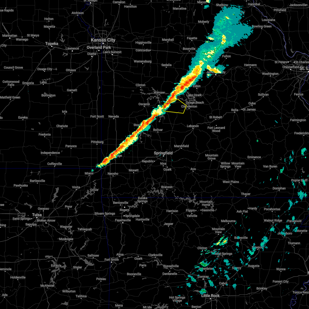 At 835 pm cst, a severe thunderstorm was located 7 miles northeast of hermitage, moving east at 35 mph (radar indicated). Hazards include 60 mph wind gusts and quarter size hail. Hail damage to vehicles is expected. Expect wind damage to roofs, siding, and trees. At 835 pm cst, a severe thunderstorm was located 7 miles northeast of hermitage, moving east at 35 mph (radar indicated). Hazards include 60 mph wind gusts and quarter size hail. Hail damage to vehicles is expected. Expect wind damage to roofs, siding, and trees.
|
| 6/11/2021 6:55 PM CDT |
 At 654 pm cdt, severe thunderstorms were located along a line extending from near osage beach to 6 miles southeast of macks creek to near buffalo, moving southeast at 25 mph (radar indicated). Hazards include 60 mph wind gusts and half dollar size hail. Hail damage to vehicles is expected. Expect wind damage to roofs, siding, and trees. At 654 pm cdt, severe thunderstorms were located along a line extending from near osage beach to 6 miles southeast of macks creek to near buffalo, moving southeast at 25 mph (radar indicated). Hazards include 60 mph wind gusts and half dollar size hail. Hail damage to vehicles is expected. Expect wind damage to roofs, siding, and trees.
|
| 6/11/2021 6:44 PM CDT | Quarter sized hail reported 0.3 miles SSW of Macks Creek, MO |
| 6/11/2021 5:58 PM CDT |
 At 557 pm cdt, a severe thunderstorm was located 11 miles west of laurie, or 17 miles southwest of versailles, moving southeast at 20 mph (radar indicated). Hazards include 70 mph wind gusts and quarter size hail. Hail damage to vehicles is expected. expect considerable tree damage. Wind damage is also likely to mobile homes, roofs, and outbuildings. At 557 pm cdt, a severe thunderstorm was located 11 miles west of laurie, or 17 miles southwest of versailles, moving southeast at 20 mph (radar indicated). Hazards include 70 mph wind gusts and quarter size hail. Hail damage to vehicles is expected. expect considerable tree damage. Wind damage is also likely to mobile homes, roofs, and outbuildings.
|
| 11/14/2020 6:52 PM CST |
 At 652 pm cst, severe thunderstorms were located along a line extending from near camdenton to near pleasant hope, moving east at 40 mph (radar indicated). Hazards include golf ball size hail and 60 mph wind gusts. People and animals outdoors will be injured. expect hail damage to roofs, siding, windows, and vehicles. expect wind damage to roofs, siding, and trees. Locations impacted include, lebanon, lake of the ozarks, lake of the ozarks state park, ha ha tonka state park, bennett spring state park, osage beach, camdenton, buffalo, village of four seasons, richland, lake ozark, conway, iberia, pleasant hope, sunrise beach, morrisville, macks creek, linn creek, phillipsburg, stoutland, this includes interstate 44 between mile markers 109 and 143. At 652 pm cst, severe thunderstorms were located along a line extending from near camdenton to near pleasant hope, moving east at 40 mph (radar indicated). Hazards include golf ball size hail and 60 mph wind gusts. People and animals outdoors will be injured. expect hail damage to roofs, siding, windows, and vehicles. expect wind damage to roofs, siding, and trees. Locations impacted include, lebanon, lake of the ozarks, lake of the ozarks state park, ha ha tonka state park, bennett spring state park, osage beach, camdenton, buffalo, village of four seasons, richland, lake ozark, conway, iberia, pleasant hope, sunrise beach, morrisville, macks creek, linn creek, phillipsburg, stoutland, this includes interstate 44 between mile markers 109 and 143.
|
| 11/14/2020 6:45 PM CST |
 At 645 pm cst, severe thunderstorms were located along a line extending from near camdenton to near pleasant hope, moving east at 40 mph (radar indicated). Hazards include 60 mph wind gusts and quarter size hail. Hail damage to vehicles is expected. Expect wind damage to roofs, siding, and trees. At 645 pm cst, severe thunderstorms were located along a line extending from near camdenton to near pleasant hope, moving east at 40 mph (radar indicated). Hazards include 60 mph wind gusts and quarter size hail. Hail damage to vehicles is expected. Expect wind damage to roofs, siding, and trees.
|
| 9/27/2020 4:35 PM CDT |
 The severe thunderstorm warning for northeastern dallas, northwestern laclede and southwestern camden counties will expire at 445 pm cdt, the storm which prompted the warning has weakened below severe limits, and no longer poses an immediate threat to life or property. therefore, the warning will be allowed to expire. however gusty winds are still possible with this thunderstorm. to report severe weather, contact your nearest law enforcement agency. they will relay your report to the national weather service springfield. The severe thunderstorm warning for northeastern dallas, northwestern laclede and southwestern camden counties will expire at 445 pm cdt, the storm which prompted the warning has weakened below severe limits, and no longer poses an immediate threat to life or property. therefore, the warning will be allowed to expire. however gusty winds are still possible with this thunderstorm. to report severe weather, contact your nearest law enforcement agency. they will relay your report to the national weather service springfield.
|
| 9/27/2020 4:17 PM CDT |
 At 417 pm cdt, a severe thunderstorm was located near macks creek, or 9 miles southwest of camdenton, moving east at 25 mph (radar indicated). Hazards include 60 mph wind gusts and nickel size hail. Expect damage to roofs, siding, and trees. Locations impacted include, lake of the ozarks, ha ha tonka state park, camdenton, macks creek, linn creek, eldridge, decaturville, roach,. At 417 pm cdt, a severe thunderstorm was located near macks creek, or 9 miles southwest of camdenton, moving east at 25 mph (radar indicated). Hazards include 60 mph wind gusts and nickel size hail. Expect damage to roofs, siding, and trees. Locations impacted include, lake of the ozarks, ha ha tonka state park, camdenton, macks creek, linn creek, eldridge, decaturville, roach,.
|
| 9/27/2020 3:49 PM CDT |
 At 349 pm cdt, a severe thunderstorm was located near urbana, or 10 miles east of hermitage, moving east at 25 mph (radar indicated). Hazards include 60 mph wind gusts and nickel size hail. expect damage to roofs, siding, and trees At 349 pm cdt, a severe thunderstorm was located near urbana, or 10 miles east of hermitage, moving east at 25 mph (radar indicated). Hazards include 60 mph wind gusts and nickel size hail. expect damage to roofs, siding, and trees
|
| 8/10/2020 7:35 PM CDT |
 The severe thunderstorm warning for hickory, dallas, northern polk and southwestern camden counties will expire at 745 pm cdt, the storms which prompted the warning have weakened below severe limits, and no longer pose an immediate threat to life or property. therefore, the warning will be allowed to expire. however gusty winds and heavy rain are still possible with these thunderstorms. The severe thunderstorm warning for hickory, dallas, northern polk and southwestern camden counties will expire at 745 pm cdt, the storms which prompted the warning have weakened below severe limits, and no longer pose an immediate threat to life or property. therefore, the warning will be allowed to expire. however gusty winds and heavy rain are still possible with these thunderstorms.
|
| 8/10/2020 6:54 PM CDT |
 At 654 pm cdt, severe thunderstorms were located along a line extending from near hermitage to near urbana to 10 miles north of bolivar to near humansville, moving east at 35 mph (radar indicated). Hazards include 60 mph wind gusts and nickel size hail. expect damage to roofs, siding, and trees At 654 pm cdt, severe thunderstorms were located along a line extending from near hermitage to near urbana to 10 miles north of bolivar to near humansville, moving east at 35 mph (radar indicated). Hazards include 60 mph wind gusts and nickel size hail. expect damage to roofs, siding, and trees
|
| 7/20/2020 1:10 PM CDT |
 The severe thunderstorm warning for southwestern camden county will expire at 115 pm cdt, the storms which prompted the warning have weakened below severe limits, and no longer pose an immediate threat to life or property. therefore, the warning will be allowed to expire. however gusty winds are still possible with these thunderstorms. The severe thunderstorm warning for southwestern camden county will expire at 115 pm cdt, the storms which prompted the warning have weakened below severe limits, and no longer pose an immediate threat to life or property. therefore, the warning will be allowed to expire. however gusty winds are still possible with these thunderstorms.
|
| 7/20/2020 1:01 PM CDT |
 At 101 pm cdt, severe thunderstorms were located along a line extending from camdenton to 15 miles southwest of osage beach to near macks creek, moving east at 20 mph (radar indicated). Hazards include 60 mph wind gusts and quarter size hail. Hail damage to vehicles is expected. expect wind damage to roofs, siding, and trees. Locations impacted include, lake of the ozarks, ha ha tonka state park, lake of the ozarks state park, camdenton, macks creek, linn creek, old linn creek, roach,. At 101 pm cdt, severe thunderstorms were located along a line extending from camdenton to 15 miles southwest of osage beach to near macks creek, moving east at 20 mph (radar indicated). Hazards include 60 mph wind gusts and quarter size hail. Hail damage to vehicles is expected. expect wind damage to roofs, siding, and trees. Locations impacted include, lake of the ozarks, ha ha tonka state park, lake of the ozarks state park, camdenton, macks creek, linn creek, old linn creek, roach,.
|
| 7/20/2020 12:45 PM CDT |
 At 1245 pm cdt, severe thunderstorms were located along a line extending from 9 miles west of camdenton to macks creek, moving southeast at 15 mph (radar indicated). Hazards include 60 mph wind gusts and quarter size hail. Hail damage to vehicles is expected. expect wind damage to roofs, siding, and trees. these severe storms will be near, camdenton around 115 pm cdt. Other locations impacted by these severe thunderstorms include ha ha tonka state park, lake of the ozarks state park, lake of the ozarks, linn creek, old linn creek and roach. At 1245 pm cdt, severe thunderstorms were located along a line extending from 9 miles west of camdenton to macks creek, moving southeast at 15 mph (radar indicated). Hazards include 60 mph wind gusts and quarter size hail. Hail damage to vehicles is expected. expect wind damage to roofs, siding, and trees. these severe storms will be near, camdenton around 115 pm cdt. Other locations impacted by these severe thunderstorms include ha ha tonka state park, lake of the ozarks state park, lake of the ozarks, linn creek, old linn creek and roach.
|
| 7/20/2020 12:34 PM CDT |
 At 1233 pm cdt, a severe thunderstorm was located near macks creek, or 13 miles west of camdenton, moving southeast at 15 mph (radar indicated). Hazards include 60 mph wind gusts and quarter size hail. Hail damage to vehicles is expected. expect wind damage to roofs, siding, and trees. this severe thunderstorm will be near, macks creek around 1255 pm cdt. Other locations impacted by this severe thunderstorm include ha ha tonka state park, lake of the ozarks state park, lake of the ozarks, linn creek, old linn creek, green bay terrace, barnumton and roach. At 1233 pm cdt, a severe thunderstorm was located near macks creek, or 13 miles west of camdenton, moving southeast at 15 mph (radar indicated). Hazards include 60 mph wind gusts and quarter size hail. Hail damage to vehicles is expected. expect wind damage to roofs, siding, and trees. this severe thunderstorm will be near, macks creek around 1255 pm cdt. Other locations impacted by this severe thunderstorm include ha ha tonka state park, lake of the ozarks state park, lake of the ozarks, linn creek, old linn creek, green bay terrace, barnumton and roach.
|
| 5/4/2020 1:43 PM CDT |
 At 143 pm cdt, severe thunderstorms were located along a line extending from 7 miles southeast of versailles to 8 miles northeast of macks creek to near buffalo, moving east at 30 mph (radar indicated). Hazards include 60 mph wind gusts and quarter size hail. Hail damage to vehicles is expected. expect wind damage to roofs, siding, and trees. Locations impacted include, lake of the ozarks, ha ha tonka state park, lake of the ozarks state park, osage beach, camdenton, village of four seasons, laurie, sunrise beach, macks creek, linn creek, gravois mills, climax springs, rocky mount, green bay terrace, hurricane deck, old linn creek, branch, barnumton, decaturville, purvis,. At 143 pm cdt, severe thunderstorms were located along a line extending from 7 miles southeast of versailles to 8 miles northeast of macks creek to near buffalo, moving east at 30 mph (radar indicated). Hazards include 60 mph wind gusts and quarter size hail. Hail damage to vehicles is expected. expect wind damage to roofs, siding, and trees. Locations impacted include, lake of the ozarks, ha ha tonka state park, lake of the ozarks state park, osage beach, camdenton, village of four seasons, laurie, sunrise beach, macks creek, linn creek, gravois mills, climax springs, rocky mount, green bay terrace, hurricane deck, old linn creek, branch, barnumton, decaturville, purvis,.
|
| 5/4/2020 1:20 PM CDT |
 At 120 pm cdt, severe thunderstorms were located along a line extending from near otterville to near stover to near hermitage, moving east at 45 mph (radar indicated). Hazards include 60 mph wind gusts and quarter size hail. Hail damage to vehicles is expected. Expect wind damage to roofs, siding, and trees. At 120 pm cdt, severe thunderstorms were located along a line extending from near otterville to near stover to near hermitage, moving east at 45 mph (radar indicated). Hazards include 60 mph wind gusts and quarter size hail. Hail damage to vehicles is expected. Expect wind damage to roofs, siding, and trees.
|
| 5/4/2020 12:27 PM CDT |
 At 1227 pm cdt, severe thunderstorms were located along a line extending from near hermitage to near urbana to near buffalo, moving east at 45 mph (radar indicated). Hazards include ping pong ball size hail and 60 mph wind gusts. People and animals outdoors will be injured. expect hail damage to roofs, siding, windows, and vehicles. Expect wind damage to roofs, siding, and trees. At 1227 pm cdt, severe thunderstorms were located along a line extending from near hermitage to near urbana to near buffalo, moving east at 45 mph (radar indicated). Hazards include ping pong ball size hail and 60 mph wind gusts. People and animals outdoors will be injured. expect hail damage to roofs, siding, windows, and vehicles. Expect wind damage to roofs, siding, and trees.
|
| 4/28/2020 7:02 PM CDT |
 At 701 pm cdt, severe thunderstorms were located along a line extending from 8 miles southwest of laurie to 6 miles east of macks creek to 12 miles east of urbana, moving east at 40 mph (radar indicated). Hazards include 60 mph wind gusts and penny size hail. Expect damage to roofs, siding, and trees. Locations impacted include, lake of the ozarks, lake of the ozarks state park, ha ha tonka state park, osage beach, camdenton, village of four seasons, lake ozark, sunrise beach, macks creek, linn creek, climax springs, eldridge, green bay terrace, leadmine, freedom, hurricane deck, old linn creek, branch, barnumton, decaturville,. At 701 pm cdt, severe thunderstorms were located along a line extending from 8 miles southwest of laurie to 6 miles east of macks creek to 12 miles east of urbana, moving east at 40 mph (radar indicated). Hazards include 60 mph wind gusts and penny size hail. Expect damage to roofs, siding, and trees. Locations impacted include, lake of the ozarks, lake of the ozarks state park, ha ha tonka state park, osage beach, camdenton, village of four seasons, lake ozark, sunrise beach, macks creek, linn creek, climax springs, eldridge, green bay terrace, leadmine, freedom, hurricane deck, old linn creek, branch, barnumton, decaturville,.
|
| 4/28/2020 6:46 PM CDT |
 At 645 pm cdt, severe thunderstorms were located along a line extending from 15 miles northeast of hermitage to near macks creek to near urbana, moving east at 40 mph (radar indicated). Hazards include 60 mph wind gusts and quarter size hail. Hail damage to vehicles is expected. Expect wind damage to roofs, siding, and trees. At 645 pm cdt, severe thunderstorms were located along a line extending from 15 miles northeast of hermitage to near macks creek to near urbana, moving east at 40 mph (radar indicated). Hazards include 60 mph wind gusts and quarter size hail. Hail damage to vehicles is expected. Expect wind damage to roofs, siding, and trees.
|
| 11/29/2019 7:21 PM CST |
 At 721 pm cst, a severe thunderstorm was located near hermitage, moving northeast at 50 mph (radar indicated). Hazards include quarter size hail. damage to vehicles is expected At 721 pm cst, a severe thunderstorm was located near hermitage, moving northeast at 50 mph (radar indicated). Hazards include quarter size hail. damage to vehicles is expected
|
| 9/28/2019 11:11 PM CDT |
 The severe thunderstorm warning for east central hickory and western camden counties will expire at 1115 pm cdt, the storms which prompted the warning have weakened below severe limits, and no longer pose an immediate threat to life or property. therefore, the warning will be allowed to expire. however heavy rain is still possible with these thunderstorms. The severe thunderstorm warning for east central hickory and western camden counties will expire at 1115 pm cdt, the storms which prompted the warning have weakened below severe limits, and no longer pose an immediate threat to life or property. therefore, the warning will be allowed to expire. however heavy rain is still possible with these thunderstorms.
|
| 9/28/2019 10:49 PM CDT |
 At 1048 pm cdt, severe thunderstorms were located along a line extending from near tipton to near village of four seasons to near laurie, moving east at 25 mph (radar indicated). Hazards include 60 mph wind gusts. Expect damage to roofs, siding, and trees. Locations impacted include, lake of the ozarks, osage beach, village of four seasons, lake ozark, sunrise beach, macks creek, preston, green bay terrace, hurricane deck, branch, barnumton, purvis, roach,. At 1048 pm cdt, severe thunderstorms were located along a line extending from near tipton to near village of four seasons to near laurie, moving east at 25 mph (radar indicated). Hazards include 60 mph wind gusts. Expect damage to roofs, siding, and trees. Locations impacted include, lake of the ozarks, osage beach, village of four seasons, lake ozark, sunrise beach, macks creek, preston, green bay terrace, hurricane deck, branch, barnumton, purvis, roach,.
|
| 9/28/2019 10:22 PM CDT |
 At 1022 pm cdt, severe thunderstorms were located along a line extending from 8 miles northeast of stover to 8 miles south of versailles to laurie to 8 miles north of macks creek, moving east at 25 mph (radar indicated). Hazards include 60 mph wind gusts. expect damage to roofs, siding, and trees At 1022 pm cdt, severe thunderstorms were located along a line extending from 8 miles northeast of stover to 8 miles south of versailles to laurie to 8 miles north of macks creek, moving east at 25 mph (radar indicated). Hazards include 60 mph wind gusts. expect damage to roofs, siding, and trees
|
| 8/16/2019 3:05 AM CDT |
 The severe thunderstorm warning for eastern hickory, dallas, polk and southwestern camden counties will expire at 315 am cdt, the storms which prompted the warning have weakened below severe limits, and no longer pose an immediate threat to life or property. therefore, the warning will be allowed to expire. a severe thunderstorm watch remains in effect until 700 am cdt for central and southwestern missouri. The severe thunderstorm warning for eastern hickory, dallas, polk and southwestern camden counties will expire at 315 am cdt, the storms which prompted the warning have weakened below severe limits, and no longer pose an immediate threat to life or property. therefore, the warning will be allowed to expire. a severe thunderstorm watch remains in effect until 700 am cdt for central and southwestern missouri.
|
| 8/16/2019 2:37 AM CDT |
 At 237 am cdt, severe thunderstorms were located along a line extending from near hermitage to 7 miles south of urbana to 8 miles west of buffalo to near walnut grove, moving east at 45 mph (radar indicated). Hazards include 60 mph wind gusts and penny size hail. Expect damage to roofs, siding, and trees. Locations impacted include, bolivar, pomme de terre lake, stockton lake, pomme de terre state park, bennett spring state park, buffalo, pittsburg, conway, polk, pleasant hope, hermitage, urbana, morrisville, macks creek, preston, cross timbers, halfway, bennett springs, louisburg, aldrich,. At 237 am cdt, severe thunderstorms were located along a line extending from near hermitage to 7 miles south of urbana to 8 miles west of buffalo to near walnut grove, moving east at 45 mph (radar indicated). Hazards include 60 mph wind gusts and penny size hail. Expect damage to roofs, siding, and trees. Locations impacted include, bolivar, pomme de terre lake, stockton lake, pomme de terre state park, bennett spring state park, buffalo, pittsburg, conway, polk, pleasant hope, hermitage, urbana, morrisville, macks creek, preston, cross timbers, halfway, bennett springs, louisburg, aldrich,.
|
| 8/16/2019 2:08 AM CDT |
 At 208 am cdt, severe thunderstorms were located along a line extending from 8 miles northwest of wheatland to near weaubleau to near humansville to 9 miles southwest of stockton, moving east at 50 mph (radar indicated). Hazards include 60 mph wind gusts and quarter size hail. Hail damage to vehicles is expected. Expect wind damage to roofs, siding, and trees. At 208 am cdt, severe thunderstorms were located along a line extending from 8 miles northwest of wheatland to near weaubleau to near humansville to 9 miles southwest of stockton, moving east at 50 mph (radar indicated). Hazards include 60 mph wind gusts and quarter size hail. Hail damage to vehicles is expected. Expect wind damage to roofs, siding, and trees.
|
| 8/16/2019 12:50 AM CDT |
 A severe thunderstorm warning remains in effect until 100 am cdt for west central miller. northwestern camden and southern morgan counties. At 1249 am cdt, severe thunderstorms were located along a line extending from 7 miles northwest of village of four seasons to laurie to 13 miles north of macks creek, moving southeast at 40 mph. A severe thunderstorm warning remains in effect until 100 am cdt for west central miller. northwestern camden and southern morgan counties. At 1249 am cdt, severe thunderstorms were located along a line extending from 7 miles northwest of village of four seasons to laurie to 13 miles north of macks creek, moving southeast at 40 mph.
|
| 8/16/2019 12:34 AM CDT |
 A severe thunderstorm warning remains in effect until 100 am cdt for southeastern benton. northwestern miller. northwestern camden and southern morgan counties. At 1234 am cdt, severe thunderstorms were located along a line extending from near stover to 11 miles northwest of laurie to 14 miles southeast of cole camp, moving southeast at 45 mph. A severe thunderstorm warning remains in effect until 100 am cdt for southeastern benton. northwestern miller. northwestern camden and southern morgan counties. At 1234 am cdt, severe thunderstorms were located along a line extending from near stover to 11 miles northwest of laurie to 14 miles southeast of cole camp, moving southeast at 45 mph.
|
| 8/16/2019 12:22 AM CDT |
 At 1222 am cdt, severe thunderstorms were located along a line extending from near stover to 12 miles east of lincoln to 7 miles south of cole camp, moving southeast at 45 mph (radar indicated). Hazards include 70 mph wind gusts and half dollar size hail. Hail damage to vehicles is expected. expect considerable tree damage. Wind damage is also likely to mobile homes, roofs, and outbuildings. At 1222 am cdt, severe thunderstorms were located along a line extending from near stover to 12 miles east of lincoln to 7 miles south of cole camp, moving southeast at 45 mph (radar indicated). Hazards include 70 mph wind gusts and half dollar size hail. Hail damage to vehicles is expected. expect considerable tree damage. Wind damage is also likely to mobile homes, roofs, and outbuildings.
|
| 6/23/2019 12:35 AM CDT |
 The severe thunderstorm warning for western miller, central camden and southeastern morgan counties will expire at 1245 am cdt, the storms which prompted the warning have weakened below severe limits, and no longer pose an immediate threat to life or property. therefore, the warning will be allowed to expire. however gusty winds are still possible with these thunderstorms. a severe thunderstorm watch remains in effect until 500 am cdt for central missouri. The severe thunderstorm warning for western miller, central camden and southeastern morgan counties will expire at 1245 am cdt, the storms which prompted the warning have weakened below severe limits, and no longer pose an immediate threat to life or property. therefore, the warning will be allowed to expire. however gusty winds are still possible with these thunderstorms. a severe thunderstorm watch remains in effect until 500 am cdt for central missouri.
|
| 6/23/2019 12:21 AM CDT |
 At 1220 am cdt, severe thunderstorms were located along a line extending from near high point to village of four seasons to macks creek, moving east at 55 mph (radar indicated). Hazards include 60 mph wind gusts. Expect damage to roofs, siding, and trees. Locations impacted include, lake of the ozarks, lake of the ozarks state park, ha ha tonka state park, eldon, osage beach, camdenton, village of four seasons, lake ozark, laurie, sunrise beach, macks creek, linn creek, tuscumbia, barnett, olean, bagnell, brumley, etterville, freedom, kaiser,. At 1220 am cdt, severe thunderstorms were located along a line extending from near high point to village of four seasons to macks creek, moving east at 55 mph (radar indicated). Hazards include 60 mph wind gusts. Expect damage to roofs, siding, and trees. Locations impacted include, lake of the ozarks, lake of the ozarks state park, ha ha tonka state park, eldon, osage beach, camdenton, village of four seasons, lake ozark, laurie, sunrise beach, macks creek, linn creek, tuscumbia, barnett, olean, bagnell, brumley, etterville, freedom, kaiser,.
|
| 6/22/2019 11:51 PM CDT |
 At 1150 pm cdt, severe thunderstorms were located along a line extending from near smithton to 7 miles southwest of stover to 10 miles east of warsaw to 9 miles north of wheatland to near weaubleau, moving east at 50 mph (radar indicated). Hazards include 60 mph wind gusts. expect damage to roofs, siding, and trees At 1150 pm cdt, severe thunderstorms were located along a line extending from near smithton to 7 miles southwest of stover to 10 miles east of warsaw to 9 miles north of wheatland to near weaubleau, moving east at 50 mph (radar indicated). Hazards include 60 mph wind gusts. expect damage to roofs, siding, and trees
|
| 5/23/2019 12:20 AM CDT |
 At 1220 am cdt, a severe thunderstorm was located near urbana, or 9 miles east of hermitage, moving east at 40 mph (radar indicated). Hazards include 60 mph wind gusts and quarter size hail. Hail damage to vehicles is expected. Expect wind damage to roofs, siding, and trees. At 1220 am cdt, a severe thunderstorm was located near urbana, or 9 miles east of hermitage, moving east at 40 mph (radar indicated). Hazards include 60 mph wind gusts and quarter size hail. Hail damage to vehicles is expected. Expect wind damage to roofs, siding, and trees.
|
| 5/20/2019 8:16 PM CDT |
 At 816 pm cdt, severe thunderstorms were located along a line extending from near urbana to 7 miles northwest of buffalo to 7 miles north of pleasant hope, moving northeast at 50 mph (radar indicated). Hazards include 60 mph wind gusts. expect damage to roofs, siding, and trees At 816 pm cdt, severe thunderstorms were located along a line extending from near urbana to 7 miles northwest of buffalo to 7 miles north of pleasant hope, moving northeast at 50 mph (radar indicated). Hazards include 60 mph wind gusts. expect damage to roofs, siding, and trees
|
| 5/18/2019 4:26 PM CDT |
 The severe thunderstorm warning for hickory, northern webster, dallas, northwestern wright, southeastern benton, western laclede, eastern polk, eastern greene and southwestern camden counties will expire at 430 pm cdt, the storms which prompted the warning have weakened below severe limits, and no longer pose an immediate threat to life or property. therefore, the warning will be allowed to expire. however gusty winds are still possible with these thunderstorms. a tornado watch remains in effect until 500 pm cdt for central and southwestern missouri. The severe thunderstorm warning for hickory, northern webster, dallas, northwestern wright, southeastern benton, western laclede, eastern polk, eastern greene and southwestern camden counties will expire at 430 pm cdt, the storms which prompted the warning have weakened below severe limits, and no longer pose an immediate threat to life or property. therefore, the warning will be allowed to expire. however gusty winds are still possible with these thunderstorms. a tornado watch remains in effect until 500 pm cdt for central and southwestern missouri.
|
| 5/18/2019 4:03 PM CDT |
 At 403 pm cdt, severe thunderstorms were located along a line extending from near wheatland to near urbana to near buffalo to near strafford, moving northeast at 50 mph (radar indicated). Hazards include 60 mph wind gusts. Expect damage to roofs, siding, and trees. Locations impacted include, northeastern springfield, lebanon, pomme de terre lake, pomme de terre state park, bennett spring state park, marshfield, buffalo, strafford, morgan, fair grove, pittsburg, conway, polk, hermitage, urbana, niangua, wheatland, macks creek, preston, cross timbers, this includes interstate 44 between mile markers 81 and 124. At 403 pm cdt, severe thunderstorms were located along a line extending from near wheatland to near urbana to near buffalo to near strafford, moving northeast at 50 mph (radar indicated). Hazards include 60 mph wind gusts. Expect damage to roofs, siding, and trees. Locations impacted include, northeastern springfield, lebanon, pomme de terre lake, pomme de terre state park, bennett spring state park, marshfield, buffalo, strafford, morgan, fair grove, pittsburg, conway, polk, hermitage, urbana, niangua, wheatland, macks creek, preston, cross timbers, this includes interstate 44 between mile markers 81 and 124.
|
| 5/18/2019 3:51 PM CDT |
 A severe thunderstorm warning remains in effect until 430 pm cdt for hickory. northern webster. dallas. northwestern wright. southeastern benton. western laclede. polk. eastern greene. southeastern st. clair and southwestern camden counties. At 350 pm cdt, severe thunderstorms were located along a line extending from weaubleau to 11 miles east of humansville to 7 miles. A severe thunderstorm warning remains in effect until 430 pm cdt for hickory. northern webster. dallas. northwestern wright. southeastern benton. western laclede. polk. eastern greene. southeastern st. clair and southwestern camden counties. At 350 pm cdt, severe thunderstorms were located along a line extending from weaubleau to 11 miles east of humansville to 7 miles.
|
| 5/18/2019 3:38 PM CDT |
 At 337 pm cdt, severe thunderstorms were located along a line extending from near humansville to near fair play to near morrisville to near pleasant hope to springfield, moving northeast at 50 mph (radar indicated). Hazards include 60 mph wind gusts. expect damage to roofs, siding, and trees At 337 pm cdt, severe thunderstorms were located along a line extending from near humansville to near fair play to near morrisville to near pleasant hope to springfield, moving northeast at 50 mph (radar indicated). Hazards include 60 mph wind gusts. expect damage to roofs, siding, and trees
|
| 4/18/2019 1:43 AM CDT |
 At 142 am cdt, severe thunderstorms were located along a line extending from near hermitage to near buffalo to near strafford, moving east at 60 mph (radar indicated). Hazards include 70 mph wind gusts. Expect considerable tree damage. Damage is likely to mobile homes, roofs, and outbuildings. At 142 am cdt, severe thunderstorms were located along a line extending from near hermitage to near buffalo to near strafford, moving east at 60 mph (radar indicated). Hazards include 70 mph wind gusts. Expect considerable tree damage. Damage is likely to mobile homes, roofs, and outbuildings.
|
| 2/6/2019 11:28 PM CST |
 The severe thunderstorm warning for northern dallas, northwestern laclede and southwestern camden counties will expire at 1130 pm cst, the storm which prompted the warning has weakened below severe limits, and has exited the warned area. therefore, the warning will be allowed to expire. The severe thunderstorm warning for northern dallas, northwestern laclede and southwestern camden counties will expire at 1130 pm cst, the storm which prompted the warning has weakened below severe limits, and has exited the warned area. therefore, the warning will be allowed to expire.
|
| 2/6/2019 11:13 PM CST |
 At 1112 pm cst, a severe thunderstorm was located 12 miles northwest of lebanon, moving northeast at 65 mph (radar indicated). Hazards include quarter size hail. Damage to vehicles is expected. Locations impacted include, bennett spring state park, ha ha tonka state park, macks creek, bennett springs, louisburg, windyville, eldridge, leadmine, tunas, pumpkin center, branch, decaturville, plad,. At 1112 pm cst, a severe thunderstorm was located 12 miles northwest of lebanon, moving northeast at 65 mph (radar indicated). Hazards include quarter size hail. Damage to vehicles is expected. Locations impacted include, bennett spring state park, ha ha tonka state park, macks creek, bennett springs, louisburg, windyville, eldridge, leadmine, tunas, pumpkin center, branch, decaturville, plad,.
|
| 2/6/2019 10:48 PM CST |
 At 1048 pm cst, a severe thunderstorm was located 8 miles north of fair grove, or 10 miles south of buffalo, moving northeast at 65 mph. quarter size hail has been reported in fair grove (trained weather spotters). Hazards include quarter size hail. damage to vehicles is expected At 1048 pm cst, a severe thunderstorm was located 8 miles north of fair grove, or 10 miles south of buffalo, moving northeast at 65 mph. quarter size hail has been reported in fair grove (trained weather spotters). Hazards include quarter size hail. damage to vehicles is expected
|
| 12/1/2018 1:45 AM CST |
 At 145 am cst, severe thunderstorms were located along a line extending from 8 miles northwest of warsaw to near conway, moving east at 55 mph (radar indicated). Hazards include 60 mph wind gusts. expect damage to roofs, siding, and trees At 145 am cst, severe thunderstorms were located along a line extending from 8 miles northwest of warsaw to near conway, moving east at 55 mph (radar indicated). Hazards include 60 mph wind gusts. expect damage to roofs, siding, and trees
|
| 7/20/2018 3:39 AM CDT |
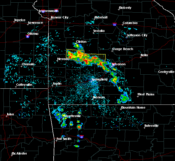 At 327 am cdt, a severe thunderstorm was located over hermitage, moving east at 45 mph (radar indicated). Hazards include half dollar size hail. damage to vehicles is expected At 327 am cdt, a severe thunderstorm was located over hermitage, moving east at 45 mph (radar indicated). Hazards include half dollar size hail. damage to vehicles is expected
|
| 7/20/2018 3:27 AM CDT |
 At 327 am cdt, a severe thunderstorm was located over hermitage, moving east at 45 mph (radar indicated). Hazards include half dollar size hail. damage to vehicles is expected At 327 am cdt, a severe thunderstorm was located over hermitage, moving east at 45 mph (radar indicated). Hazards include half dollar size hail. damage to vehicles is expected
|
| 7/19/2018 12:52 PM CDT |
 The severe thunderstorm warning for central camden county will expire at 100 pm cdt, the storms which prompted the warning have weakened below severe limits, and no longer pose an immediate threat to life or property. therefore, the warning will be allowed to expire. however heavy rain is still possible with these thunderstorms. a severe thunderstorm watch remains in effect until 900 pm cdt for central missouri. The severe thunderstorm warning for central camden county will expire at 100 pm cdt, the storms which prompted the warning have weakened below severe limits, and no longer pose an immediate threat to life or property. therefore, the warning will be allowed to expire. however heavy rain is still possible with these thunderstorms. a severe thunderstorm watch remains in effect until 900 pm cdt for central missouri.
|
| 7/19/2018 12:39 PM CDT |
 At 1239 pm cdt, severe thunderstorms were located along a line extending from near osage beach to near camdenton to macks creek, moving east at 30 mph (radar indicated). Hazards include 60 mph wind gusts and quarter size hail. Hail damage to vehicles is expected. expect wind damage to roofs, siding, and trees. Locations impacted include, lake of the ozarks, lake of the ozarks state park, ha ha tonka state park, osage beach, camdenton, lake ozark, linn creek, old linn creek, green bay terrace, montreal, freedom, roach,. At 1239 pm cdt, severe thunderstorms were located along a line extending from near osage beach to near camdenton to macks creek, moving east at 30 mph (radar indicated). Hazards include 60 mph wind gusts and quarter size hail. Hail damage to vehicles is expected. expect wind damage to roofs, siding, and trees. Locations impacted include, lake of the ozarks, lake of the ozarks state park, ha ha tonka state park, osage beach, camdenton, lake ozark, linn creek, old linn creek, green bay terrace, montreal, freedom, roach,.
|
| 7/19/2018 12:20 PM CDT |
 At 1219 pm cdt, severe thunderstorms were located along a line extending from near village of four seasons to 8 miles northwest of camdenton to 8 miles northwest of macks creek, moving southeast at 40 mph (radar indicated). Hazards include 60 mph wind gusts and quarter size hail. Hail damage to vehicles is expected. expect wind damage to roofs, siding, and trees. Locations impacted include, lake of the ozarks, lake of the ozarks state park, ha ha tonka state park, osage beach, camdenton, village of four seasons, warsaw, lake ozark, laurie, sunrise beach, macks creek, linn creek, preston, cross timbers, climax springs, freedom, fristoe, knobby, hurricane deck, old linn creek,. At 1219 pm cdt, severe thunderstorms were located along a line extending from near village of four seasons to 8 miles northwest of camdenton to 8 miles northwest of macks creek, moving southeast at 40 mph (radar indicated). Hazards include 60 mph wind gusts and quarter size hail. Hail damage to vehicles is expected. expect wind damage to roofs, siding, and trees. Locations impacted include, lake of the ozarks, lake of the ozarks state park, ha ha tonka state park, osage beach, camdenton, village of four seasons, warsaw, lake ozark, laurie, sunrise beach, macks creek, linn creek, preston, cross timbers, climax springs, freedom, fristoe, knobby, hurricane deck, old linn creek,.
|
| 7/19/2018 12:09 PM CDT |
 At 1209 pm cdt, severe thunderstorms were located along a line extending from village of four seasons to 14 miles northwest of macks creek, moving southeast at 35 mph (radar indicated). Hazards include 60 mph wind gusts and quarter size hail. Hail damage to vehicles is expected. expect wind damage to roofs, siding, and trees. Locations impacted include, lake of the ozarks, truman lake, truman state park, lake of the ozarks state park, ha ha tonka state park, osage beach, camdenton, village of four seasons, warsaw, lake ozark, laurie, hermitage, sunrise beach, macks creek, linn creek, preston, cross timbers, gravois mills, climax springs, lakeview heights,. At 1209 pm cdt, severe thunderstorms were located along a line extending from village of four seasons to 14 miles northwest of macks creek, moving southeast at 35 mph (radar indicated). Hazards include 60 mph wind gusts and quarter size hail. Hail damage to vehicles is expected. expect wind damage to roofs, siding, and trees. Locations impacted include, lake of the ozarks, truman lake, truman state park, lake of the ozarks state park, ha ha tonka state park, osage beach, camdenton, village of four seasons, warsaw, lake ozark, laurie, hermitage, sunrise beach, macks creek, linn creek, preston, cross timbers, gravois mills, climax springs, lakeview heights,.
|
| 7/19/2018 11:55 AM CDT |
 At 1154 am cdt, severe thunderstorms were located along a line extending from near laurie to near warsaw, moving southeast at 30 mph (radar indicated). Hazards include 60 mph wind gusts and quarter size hail. Hail damage to vehicles is expected. Expect wind damage to roofs, siding, and trees. At 1154 am cdt, severe thunderstorms were located along a line extending from near laurie to near warsaw, moving southeast at 30 mph (radar indicated). Hazards include 60 mph wind gusts and quarter size hail. Hail damage to vehicles is expected. Expect wind damage to roofs, siding, and trees.
|
| 6/26/2018 4:04 PM CDT |
 At 403 pm cdt, severe thunderstorms were located along a line extending from 6 miles north of iberia to 6 miles southeast of camdenton to wheatland, moving east at 35 mph (radar indicated). Hazards include 60 mph wind gusts and quarter size hail. Hail damage to vehicles is expected. expect wind damage to roofs, siding, and trees. locations impacted include, lake of the ozarks, pomme de terre lake, lake of the ozarks state park, ha ha tonka state park, pomme de terre state park, osage beach, camdenton, village of four seasons, lake ozark, laurie, iberia, hermitage, sunrise beach, weaubleau, wheatland, st. Elizabeth, saint elizabeth, macks creek, linn creek, preston,. At 403 pm cdt, severe thunderstorms were located along a line extending from 6 miles north of iberia to 6 miles southeast of camdenton to wheatland, moving east at 35 mph (radar indicated). Hazards include 60 mph wind gusts and quarter size hail. Hail damage to vehicles is expected. expect wind damage to roofs, siding, and trees. locations impacted include, lake of the ozarks, pomme de terre lake, lake of the ozarks state park, ha ha tonka state park, pomme de terre state park, osage beach, camdenton, village of four seasons, lake ozark, laurie, iberia, hermitage, sunrise beach, weaubleau, wheatland, st. Elizabeth, saint elizabeth, macks creek, linn creek, preston,.
|
| 6/26/2018 3:37 PM CDT |
 At 337 pm cdt, severe thunderstorms were located along a line extending from 6 miles south of hickory hill to 8 miles east of lowry city, moving east at 55 mph (radar indicated). Hazards include 60 mph wind gusts and quarter size hail. Hail damage to vehicles is expected. Expect wind damage to roofs, siding, and trees. At 337 pm cdt, severe thunderstorms were located along a line extending from 6 miles south of hickory hill to 8 miles east of lowry city, moving east at 55 mph (radar indicated). Hazards include 60 mph wind gusts and quarter size hail. Hail damage to vehicles is expected. Expect wind damage to roofs, siding, and trees.
|
| 5/19/2018 12:07 PM CDT | Numerous small limbs down with some limbs to 4 inches in diameter. power was also reported ou in camden county MO, 8.1 miles SSW of Macks Creek, MO |
| 5/14/2018 6:26 PM CDT |
 The severe thunderstorm warning for southern miller, northwestern pulaski and central camden counties will expire at 630 pm cdt, the storm which prompted the warning has weakened below severe limits, and has exited the warned area. therefore, the warning will be allowed to expire. a severe thunderstorm watch remains in effect until 1000 pm cdt for central and southwestern missouri. The severe thunderstorm warning for southern miller, northwestern pulaski and central camden counties will expire at 630 pm cdt, the storm which prompted the warning has weakened below severe limits, and has exited the warned area. therefore, the warning will be allowed to expire. a severe thunderstorm watch remains in effect until 1000 pm cdt for central and southwestern missouri.
|
| 5/14/2018 5:36 PM CDT | Quarter sized hail reported 2 miles NNE of Macks Creek, MO, social media pictures of hail around quarter size with a second storm that went near the macks creek area. |
| 5/14/2018 5:22 PM CDT |
 At 522 pm cdt, a severe thunderstorm was located over camdenton, moving east at 30 mph (radar indicated). Hazards include 60 mph wind gusts and quarter size hail. Hail damage to vehicles is expected. Expect wind damage to roofs, siding, and trees. At 522 pm cdt, a severe thunderstorm was located over camdenton, moving east at 30 mph (radar indicated). Hazards include 60 mph wind gusts and quarter size hail. Hail damage to vehicles is expected. Expect wind damage to roofs, siding, and trees.
|
| 5/14/2018 4:56 PM CDT |
 At 455 pm cdt, a severe thunderstorm was located near macks creek, or 7 miles west of camdenton, moving northeast at 25 mph (trained weather spotters. quarter to to half dollar size hail was reported in macks creek). Hazards include 60 mph wind gusts and half dollar size hail. Hail damage to vehicles is expected. expect wind damage to roofs, siding, and trees. Locations impacted include, lake of the ozarks, lake of the ozarks state park, ha ha tonka state park, osage beach, camdenton, village of four seasons, sunrise beach, macks creek, linn creek, green bay terrace, freedom, hurricane deck, old linn creek, roach,. At 455 pm cdt, a severe thunderstorm was located near macks creek, or 7 miles west of camdenton, moving northeast at 25 mph (trained weather spotters. quarter to to half dollar size hail was reported in macks creek). Hazards include 60 mph wind gusts and half dollar size hail. Hail damage to vehicles is expected. expect wind damage to roofs, siding, and trees. Locations impacted include, lake of the ozarks, lake of the ozarks state park, ha ha tonka state park, osage beach, camdenton, village of four seasons, sunrise beach, macks creek, linn creek, green bay terrace, freedom, hurricane deck, old linn creek, roach,.
|
| 5/14/2018 4:51 PM CDT | Half Dollar sized hail reported 1.2 miles WSW of Macks Creek, MO, quarter to half dollar size hail reported. |
| 5/14/2018 4:48 PM CDT |
 At 448 pm cdt, a severe thunderstorm was located over macks creek, or 10 miles west of camdenton, moving northeast at 25 mph (radar indicated). Hazards include 60 mph wind gusts and quarter size hail. Hail damage to vehicles is expected. Expect wind damage to roofs, siding, and trees. At 448 pm cdt, a severe thunderstorm was located over macks creek, or 10 miles west of camdenton, moving northeast at 25 mph (radar indicated). Hazards include 60 mph wind gusts and quarter size hail. Hail damage to vehicles is expected. Expect wind damage to roofs, siding, and trees.
|
| 3/16/2018 5:23 PM CDT |
 At 523 pm cdt, a severe thunderstorm was located near macks creek, or 16 miles southwest of camdenton, moving east at 55 mph (radar indicated). Hazards include 60 mph wind gusts and quarter size hail. Hail damage to vehicles is expected. Expect wind damage to roofs, siding, and trees. At 523 pm cdt, a severe thunderstorm was located near macks creek, or 16 miles southwest of camdenton, moving east at 55 mph (radar indicated). Hazards include 60 mph wind gusts and quarter size hail. Hail damage to vehicles is expected. Expect wind damage to roofs, siding, and trees.
|
| 8/18/2017 9:19 PM CDT |
 At 918 pm cdt, a severe thunderstorm was located near macks creek, or 8 miles west of camdenton, moving east at 15 mph (radar indicated). Hazards include 60 mph wind gusts and quarter size hail. Hail damage to vehicles is expected. Expect wind damage to roofs, siding, and trees. At 918 pm cdt, a severe thunderstorm was located near macks creek, or 8 miles west of camdenton, moving east at 15 mph (radar indicated). Hazards include 60 mph wind gusts and quarter size hail. Hail damage to vehicles is expected. Expect wind damage to roofs, siding, and trees.
|
| 6/17/2017 3:02 AM CDT |
 At 302 am cdt, severe thunderstorms were located along a line extending from near laurie to near macks creek to near urbana to near fair play to 8 miles west of stockton to walker, moving southeast at 55 mph (radar indicated). Hazards include 60 mph wind gusts. Expect damage to roofs, siding, and trees. Locations impacted include, bolivar, lake of the ozarks, pomme de terre lake, stockton lake, truman lake, pomme de terre state park, stockton state park, ha ha tonka state park, bennett spring state park, osage beach, camdenton, el dorado springs, buffalo, versailles, village of four seasons, stockton, pittsburg, cole camp, stover, humansville,. At 302 am cdt, severe thunderstorms were located along a line extending from near laurie to near macks creek to near urbana to near fair play to 8 miles west of stockton to walker, moving southeast at 55 mph (radar indicated). Hazards include 60 mph wind gusts. Expect damage to roofs, siding, and trees. Locations impacted include, bolivar, lake of the ozarks, pomme de terre lake, stockton lake, truman lake, pomme de terre state park, stockton state park, ha ha tonka state park, bennett spring state park, osage beach, camdenton, el dorado springs, buffalo, versailles, village of four seasons, stockton, pittsburg, cole camp, stover, humansville,.
|
| 6/17/2017 2:35 AM CDT |
 At 235 am cdt, severe thunderstorms were located along a line extending from near cole camp to 11 miles east of warsaw to 6 miles northwest of wheatland to 9 miles east of el dorado springs to 6 miles north of walker to near hume, moving southeast at 55 mph (radar indicated). Hazards include 60 mph wind gusts. expect damage to roofs, siding, and trees At 235 am cdt, severe thunderstorms were located along a line extending from near cole camp to 11 miles east of warsaw to 6 miles northwest of wheatland to 9 miles east of el dorado springs to 6 miles north of walker to near hume, moving southeast at 55 mph (radar indicated). Hazards include 60 mph wind gusts. expect damage to roofs, siding, and trees
|
| 5/27/2017 3:00 PM CDT |
 At 300 pm cdt, severe thunderstorms were located along a line extending from near macks creek to near lebanon to 7 miles east of niangua to ozark, moving east at 55 mph (emergency management). Hazards include 60 mph wind gusts and half dollar size hail. Hail damage to vehicles is expected. Expect wind damage to roofs, siding, and trees. At 300 pm cdt, severe thunderstorms were located along a line extending from near macks creek to near lebanon to 7 miles east of niangua to ozark, moving east at 55 mph (emergency management). Hazards include 60 mph wind gusts and half dollar size hail. Hail damage to vehicles is expected. Expect wind damage to roofs, siding, and trees.
|
| 5/27/2017 2:41 PM CDT |
 At 240 pm cdt, severe thunderstorms were located along a line extending from near high point to lake ozark to 8 miles west of macks creek, moving east at 55 mph (radar indicated). Hazards include 70 mph wind gusts and half dollar size hail. Hail damage to vehicles is expected. expect considerable tree damage. Wind damage is also likely to mobile homes, roofs, and outbuildings. At 240 pm cdt, severe thunderstorms were located along a line extending from near high point to lake ozark to 8 miles west of macks creek, moving east at 55 mph (radar indicated). Hazards include 70 mph wind gusts and half dollar size hail. Hail damage to vehicles is expected. expect considerable tree damage. Wind damage is also likely to mobile homes, roofs, and outbuildings.
|
| 5/26/2017 5:14 AM CDT |
 At 514 am cdt, severe thunderstorms were located along a line extending from near macks creek to 11 miles east of conway, moving east at 50 mph (radar indicated). Hazards include quarter size hail. Damage to vehicles is expected. Locations impacted include, lebanon, lake of the ozarks, lake of the ozarks state park, ha ha tonka state park, bennett spring state park, osage beach, camdenton, richland, morgan, macks creek, linn creek, phillipsburg, stoutland, bennett springs, twin bridges, competition, lynchburg, sleeper, falcon, freedom, this includes interstate 44 between mile markers 116 and 144. At 514 am cdt, severe thunderstorms were located along a line extending from near macks creek to 11 miles east of conway, moving east at 50 mph (radar indicated). Hazards include quarter size hail. Damage to vehicles is expected. Locations impacted include, lebanon, lake of the ozarks, lake of the ozarks state park, ha ha tonka state park, bennett spring state park, osage beach, camdenton, richland, morgan, macks creek, linn creek, phillipsburg, stoutland, bennett springs, twin bridges, competition, lynchburg, sleeper, falcon, freedom, this includes interstate 44 between mile markers 116 and 144.
|
| 5/26/2017 5:03 AM CDT |
 At 501 am cdt, severe thunderstorms were located along a line extending from 7 miles east of urbana to conway, moving east at 40 mph (radar indicated). Hazards include quarter size hail. Damage to vehicles is expected. locations impacted include, lebanon, lake of the ozarks, lake of the ozarks state park, ha ha tonka state park, bennett spring state park, osage beach, camdenton, richland, morgan, conway, sunrise beach, macks creek, linn creek, phillipsburg, stoutland, bennett springs, climax springs, twin bridges, competition, windyville, this includes interstate 44 between mile markers 109 and 144. These storms have a history of producing quarter sized hail. At 501 am cdt, severe thunderstorms were located along a line extending from 7 miles east of urbana to conway, moving east at 40 mph (radar indicated). Hazards include quarter size hail. Damage to vehicles is expected. locations impacted include, lebanon, lake of the ozarks, lake of the ozarks state park, ha ha tonka state park, bennett spring state park, osage beach, camdenton, richland, morgan, conway, sunrise beach, macks creek, linn creek, phillipsburg, stoutland, bennett springs, climax springs, twin bridges, competition, windyville, this includes interstate 44 between mile markers 109 and 144. These storms have a history of producing quarter sized hail.
|
| 5/26/2017 4:46 AM CDT |
 At 445 am cdt, severe thunderstorms were located along a line extending from near hermitage to buffalo, moving east at 55 mph (radar indicated). Hazards include quarter size hail. damage to vehicles is expected At 445 am cdt, severe thunderstorms were located along a line extending from near hermitage to buffalo, moving east at 55 mph (radar indicated). Hazards include quarter size hail. damage to vehicles is expected
|
| 5/19/2017 5:50 PM CDT |
 The severe thunderstorm warning for northern webster, northern wright, laclede and camden counties will expire at 600 pm cdt, the storms which prompted the warning have moved out of the area. therefore the warning will be allowed to expire. however heavy rain is still possible with these thunderstorms. a tornado watch remains in effect until 1000 pm cdt for central, south central and southwestern missouri. The severe thunderstorm warning for northern webster, northern wright, laclede and camden counties will expire at 600 pm cdt, the storms which prompted the warning have moved out of the area. therefore the warning will be allowed to expire. however heavy rain is still possible with these thunderstorms. a tornado watch remains in effect until 1000 pm cdt for central, south central and southwestern missouri.
|
| 5/19/2017 5:03 PM CDT |
 At 502 pm cdt, severe thunderstorms were located along a line extending from 6 miles southeast of weaubleau to 6 miles southeast of urbana to 8 miles west of conway to near fordland, moving northeast at 60 mph (radar indicated). Hazards include 60 mph wind gusts. expect damage to roofs, siding, and trees At 502 pm cdt, severe thunderstorms were located along a line extending from 6 miles southeast of weaubleau to 6 miles southeast of urbana to 8 miles west of conway to near fordland, moving northeast at 60 mph (radar indicated). Hazards include 60 mph wind gusts. expect damage to roofs, siding, and trees
|
| 3/9/2017 4:17 PM CST |
 At 416 pm cst, a severe thunderstorm was located over camdenton, moving east at 55 mph (radar indicated). Hazards include quarter size hail. damage to vehicles is expected At 416 pm cst, a severe thunderstorm was located over camdenton, moving east at 55 mph (radar indicated). Hazards include quarter size hail. damage to vehicles is expected
|
| 3/9/2017 2:39 PM CST |
 At 239 pm cst, a severe thunderstorm was located 7 miles northeast of macks creek, or 9 miles northwest of camdenton, moving east at 45 mph (radar indicated). Hazards include 60 mph wind gusts and half dollar size hail. Hail damage to vehicles is expected. Expect wind damage to roofs, siding, and trees. At 239 pm cst, a severe thunderstorm was located 7 miles northeast of macks creek, or 9 miles northwest of camdenton, moving east at 45 mph (radar indicated). Hazards include 60 mph wind gusts and half dollar size hail. Hail damage to vehicles is expected. Expect wind damage to roofs, siding, and trees.
|
| 3/9/2017 2:31 PM CST |
 At 230 pm cst, a severe thunderstorm was located 10 miles north of macks creek, or 15 miles northwest of camdenton, moving east at 50 mph (radar indicated). Hazards include 60 mph wind gusts and half dollar size hail. Hail damage to vehicles is expected. expect wind damage to roofs, siding, and trees. Locations impacted include, lake of the ozarks, ha ha tonka state park, lake of the ozarks state park, osage beach, camdenton, village of four seasons, laurie, sunrise beach, macks creek, linn creek, climax springs, rocky mount, green bay terrace, hurricane deck, old linn creek, barnumton, purvis, roach,. At 230 pm cst, a severe thunderstorm was located 10 miles north of macks creek, or 15 miles northwest of camdenton, moving east at 50 mph (radar indicated). Hazards include 60 mph wind gusts and half dollar size hail. Hail damage to vehicles is expected. expect wind damage to roofs, siding, and trees. Locations impacted include, lake of the ozarks, ha ha tonka state park, lake of the ozarks state park, osage beach, camdenton, village of four seasons, laurie, sunrise beach, macks creek, linn creek, climax springs, rocky mount, green bay terrace, hurricane deck, old linn creek, barnumton, purvis, roach,.
|
| 3/9/2017 1:59 PM CST |
 At 159 pm cst, a severe thunderstorm was located 10 miles northwest of macks creek, or 13 miles northeast of hermitage, moving east at 60 mph (radar indicated). Hazards include quarter size hail. Damage to vehicles is expected. Locations impacted include, lake of the ozarks, ha ha tonka state park, lake of the ozarks state park, osage beach, camdenton, village of four seasons, laurie, sunrise beach, macks creek, linn creek, climax springs, rocky mount, green bay terrace, hurricane deck, old linn creek, barnumton, purvis, roach,. At 159 pm cst, a severe thunderstorm was located 10 miles northwest of macks creek, or 13 miles northeast of hermitage, moving east at 60 mph (radar indicated). Hazards include quarter size hail. Damage to vehicles is expected. Locations impacted include, lake of the ozarks, ha ha tonka state park, lake of the ozarks state park, osage beach, camdenton, village of four seasons, laurie, sunrise beach, macks creek, linn creek, climax springs, rocky mount, green bay terrace, hurricane deck, old linn creek, barnumton, purvis, roach,.
|
| 3/9/2017 1:49 PM CST |
 At 148 pm cst, a severe thunderstorm was located 8 miles northeast of hermitage, moving east at 45 mph (emergency management. quarter size hail was reported in hermitage when the storm passed over that location). Hazards include 60 mph wind gusts and half dollar size hail. Hail damage to vehicles is expected. Expect wind damage to roofs, siding, and trees. At 148 pm cst, a severe thunderstorm was located 8 miles northeast of hermitage, moving east at 45 mph (emergency management. quarter size hail was reported in hermitage when the storm passed over that location). Hazards include 60 mph wind gusts and half dollar size hail. Hail damage to vehicles is expected. Expect wind damage to roofs, siding, and trees.
|
| 3/6/2017 11:33 PM CST | Hwy w... carports damaged... mobile home destroyed... one spotter reports it looks like a war zon in camden county MO, 0.3 miles SSW of Macks Creek, MO |
| 3/6/2017 11:17 PM CST | Confirmed structural damage on cemetery road in macks creek. waiting for additional report in camden county MO, 0.3 miles SSW of Macks Creek, MO |
| 3/6/2017 10:56 PM CST |
 At 1056 pm cst, severe thunderstorms were located along a line extending from near hickory hill to near osage beach to 7 miles south of camdenton, moving east at 45 mph (radar indicated). Hazards include 60 mph wind gusts and quarter size hail. Hail damage to vehicles is expected. expect wind damage to roofs, siding, and trees. locations impacted include, northern fort leonard wood, lake of the ozarks, lake of the ozarks state park, ha ha tonka state park, waynesville, eldon, osage beach, st. robert, camdenton, village of four seasons, richland, lake ozark, crocker, laurie, iberia, sunrise beach, urbana, saint elizabeth, st. elizabeth, macks creek, this includes interstate 44 between mile markers 154 and 158. A tornado watch remains in effect until 300 am cst for central and southwestern missouri. At 1056 pm cst, severe thunderstorms were located along a line extending from near hickory hill to near osage beach to 7 miles south of camdenton, moving east at 45 mph (radar indicated). Hazards include 60 mph wind gusts and quarter size hail. Hail damage to vehicles is expected. expect wind damage to roofs, siding, and trees. locations impacted include, northern fort leonard wood, lake of the ozarks, lake of the ozarks state park, ha ha tonka state park, waynesville, eldon, osage beach, st. robert, camdenton, village of four seasons, richland, lake ozark, crocker, laurie, iberia, sunrise beach, urbana, saint elizabeth, st. elizabeth, macks creek, this includes interstate 44 between mile markers 154 and 158. A tornado watch remains in effect until 300 am cst for central and southwestern missouri.
|
| 3/6/2017 10:29 PM CST |
 At 1029 pm cst, a severe thunderstorm capable of producing a tornado was located 7 miles north of macks creek, or 12 miles west of camdenton, moving northeast at 45 mph (radar indicated rotation). Hazards include tornado and quarter size hail. Flying debris will be dangerous to those caught without shelter. mobile homes will be damaged or destroyed. damage to roofs, windows, and vehicles will occur. Tree damage is likely. At 1029 pm cst, a severe thunderstorm capable of producing a tornado was located 7 miles north of macks creek, or 12 miles west of camdenton, moving northeast at 45 mph (radar indicated rotation). Hazards include tornado and quarter size hail. Flying debris will be dangerous to those caught without shelter. mobile homes will be damaged or destroyed. damage to roofs, windows, and vehicles will occur. Tree damage is likely.
|
| 3/6/2017 10:23 PM CST |
 At 1022 pm cst, severe thunderstorms were located along a line extending from near versailles to 10 miles west of laurie to near urbana, moving east at 45 mph (radar indicated). Hazards include 60 mph wind gusts and quarter size hail. Hail damage to vehicles is expected. expect wind damage to roofs, siding, and trees. locations impacted include, northern fort leonard wood, lake of the ozarks, pomme de terre lake, truman lake, lake of the ozarks state park, pomme de terre state park, ha ha tonka state park, waynesville, eldon, osage beach, st. robert, camdenton, village of four seasons, richland, lake ozark, pittsburg, crocker, laurie, iberia, hermitage, this includes interstate 44 between mile markers 154 and 158. A tornado watch remains in effect until 300 am cst for central, southwestern and west central missouri. At 1022 pm cst, severe thunderstorms were located along a line extending from near versailles to 10 miles west of laurie to near urbana, moving east at 45 mph (radar indicated). Hazards include 60 mph wind gusts and quarter size hail. Hail damage to vehicles is expected. expect wind damage to roofs, siding, and trees. locations impacted include, northern fort leonard wood, lake of the ozarks, pomme de terre lake, truman lake, lake of the ozarks state park, pomme de terre state park, ha ha tonka state park, waynesville, eldon, osage beach, st. robert, camdenton, village of four seasons, richland, lake ozark, pittsburg, crocker, laurie, iberia, hermitage, this includes interstate 44 between mile markers 154 and 158. A tornado watch remains in effect until 300 am cst for central, southwestern and west central missouri.
|
| 3/6/2017 10:11 PM CST |
 At 1010 pm cst, severe thunderstorms were located along a line extending from near stover to 13 miles southeast of warsaw to near hermitage, moving east at 45 mph (radar indicated). Hazards include 60 mph wind gusts and quarter size hail. Hail damage to vehicles is expected. Expect wind damage to roofs, siding, and trees. At 1010 pm cst, severe thunderstorms were located along a line extending from near stover to 13 miles southeast of warsaw to near hermitage, moving east at 45 mph (radar indicated). Hazards include 60 mph wind gusts and quarter size hail. Hail damage to vehicles is expected. Expect wind damage to roofs, siding, and trees.
|
| 3/1/2017 12:39 AM CST |
 At 1238 am cst, severe thunderstorms were located along a line extending from near eldon to near macks creek, moving east at 50 mph (radar indicated). Hazards include 60 mph wind gusts and quarter size hail. Hail damage to vehicles is expected. expect wind damage to roofs, siding, and trees. A tornado watch remains in effect until 400 am cst for central and southwestern missouri. At 1238 am cst, severe thunderstorms were located along a line extending from near eldon to near macks creek, moving east at 50 mph (radar indicated). Hazards include 60 mph wind gusts and quarter size hail. Hail damage to vehicles is expected. expect wind damage to roofs, siding, and trees. A tornado watch remains in effect until 400 am cst for central and southwestern missouri.
|
| 3/1/2017 12:12 AM CST |
 At 1211 am cst, severe thunderstorms were located along a line extending from 13 miles east of warsaw to 10 miles northeast of hermitage to 6 miles south of wheatland, moving east at 65 mph (radar indicated). Hazards include 60 mph wind gusts and quarter size hail. Hail damage to vehicles is expected. expect wind damage to roofs, siding, and trees. severe thunderstorms will be near, urbana around 1225 am cst. laurie around 1230 am cst. village of four seasons, lake ozark and macks creek around 1235 am cst. eldon and osage beach around 1240 am cst. camdenton around 1250 am cst. iberia around 110 am cst. other locations impacted by these severe thunderstorms include lake of the ozarks, pomme de terre lake, lake of the ozarks state park, ha ha tonka state park, pomme de terre state park, pittsburg, sunrise beach, st. elizabeth, saint elizabeth and linn creek. A tornado watch remains in effect until 400 am cst for central and southwestern missouri. At 1211 am cst, severe thunderstorms were located along a line extending from 13 miles east of warsaw to 10 miles northeast of hermitage to 6 miles south of wheatland, moving east at 65 mph (radar indicated). Hazards include 60 mph wind gusts and quarter size hail. Hail damage to vehicles is expected. expect wind damage to roofs, siding, and trees. severe thunderstorms will be near, urbana around 1225 am cst. laurie around 1230 am cst. village of four seasons, lake ozark and macks creek around 1235 am cst. eldon and osage beach around 1240 am cst. camdenton around 1250 am cst. iberia around 110 am cst. other locations impacted by these severe thunderstorms include lake of the ozarks, pomme de terre lake, lake of the ozarks state park, ha ha tonka state park, pomme de terre state park, pittsburg, sunrise beach, st. elizabeth, saint elizabeth and linn creek. A tornado watch remains in effect until 400 am cst for central and southwestern missouri.
|
| 10/19/2016 1:13 PM CDT |
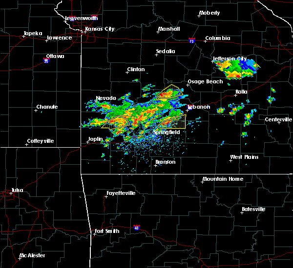 At 112 pm cdt, a severe thunderstorm was located 7 miles west of macks creek, or 11 miles east of hermitage, moving northeast at 30 mph (radar indicated). Hazards include 60 mph wind gusts and quarter size hail. Hail damage to vehicles is expected. expect wind damage to roofs, siding, and trees. Locations impacted include, lake of the ozarks, macks creek, roach, barnumton,. At 112 pm cdt, a severe thunderstorm was located 7 miles west of macks creek, or 11 miles east of hermitage, moving northeast at 30 mph (radar indicated). Hazards include 60 mph wind gusts and quarter size hail. Hail damage to vehicles is expected. expect wind damage to roofs, siding, and trees. Locations impacted include, lake of the ozarks, macks creek, roach, barnumton,.
|
| 10/19/2016 1:10 PM CDT |
 At 109 pm cdt, a severe thunderstorm was located near urbana, or 10 miles east of hermitage, moving northeast at 35 mph (radar indicated). Hazards include 60 mph wind gusts and quarter size hail. Hail damage to vehicles is expected. expect wind damage to roofs, siding, and trees. Locations impacted include, lake of the ozarks, ha ha tonka state park, camdenton, macks creek, preston, branch, barnumton, roach,. At 109 pm cdt, a severe thunderstorm was located near urbana, or 10 miles east of hermitage, moving northeast at 35 mph (radar indicated). Hazards include 60 mph wind gusts and quarter size hail. Hail damage to vehicles is expected. expect wind damage to roofs, siding, and trees. Locations impacted include, lake of the ozarks, ha ha tonka state park, camdenton, macks creek, preston, branch, barnumton, roach,.
|
| 10/19/2016 12:57 PM CDT |
 At 1257 pm cdt, a severe thunderstorm was located 3 miles west of urbana, or 8 miles southeast of hermitage, moving northeast at 30 mph (radar indicated). Hazards include 60 mph wind gusts and quarter size hail. Hail damage to vehicles is expected. Expect wind damage to roofs, siding, and trees. At 1257 pm cdt, a severe thunderstorm was located 3 miles west of urbana, or 8 miles southeast of hermitage, moving northeast at 30 mph (radar indicated). Hazards include 60 mph wind gusts and quarter size hail. Hail damage to vehicles is expected. Expect wind damage to roofs, siding, and trees.
|
| 8/25/2016 4:05 PM CDT |
 At 405 pm cdt, a severe thunderstorm was located 8 miles south of macks creek, or 15 miles southwest of camdenton, moving northeast at 25 mph (radar indicated). Hazards include 60 mph wind gusts and quarter size hail. Hail damage to vehicles is expected. Expect wind damage to roofs, siding, and trees. At 405 pm cdt, a severe thunderstorm was located 8 miles south of macks creek, or 15 miles southwest of camdenton, moving northeast at 25 mph (radar indicated). Hazards include 60 mph wind gusts and quarter size hail. Hail damage to vehicles is expected. Expect wind damage to roofs, siding, and trees.
|
| 7/13/2016 9:19 PM CDT |
 At 918 pm cdt, a severe thunderstorm was located near macks creek, or 8 miles southwest of camdenton, moving east at 20 mph (radar indicated). Hazards include 60 mph wind gusts and quarter size hail. Hail damage to vehicles is expected. Expect wind damage to roofs, siding, and trees. At 918 pm cdt, a severe thunderstorm was located near macks creek, or 8 miles southwest of camdenton, moving east at 20 mph (radar indicated). Hazards include 60 mph wind gusts and quarter size hail. Hail damage to vehicles is expected. Expect wind damage to roofs, siding, and trees.
|
| 7/13/2016 9:10 PM CDT |
 At 910 pm cdt, a severe thunderstorm was located near urbana, or 11 miles east of hermitage, moving northeast at 30 mph (radar indicated). Hazards include 60 mph wind gusts and quarter size hail. Hail damage to vehicles is expected. expect wind damage to roofs, siding, and trees. Locations impacted include, urbana, macks creek, tunas, branch, leadmine,. At 910 pm cdt, a severe thunderstorm was located near urbana, or 11 miles east of hermitage, moving northeast at 30 mph (radar indicated). Hazards include 60 mph wind gusts and quarter size hail. Hail damage to vehicles is expected. expect wind damage to roofs, siding, and trees. Locations impacted include, urbana, macks creek, tunas, branch, leadmine,.
|
| 7/13/2016 8:58 PM CDT |
 At 858 pm cdt, a severe thunderstorm was located over urbana, or 8 miles southeast of hermitage, moving northeast at 30 mph (radar indicated). Hazards include 60 mph wind gusts and quarter size hail. Hail damage to vehicles is expected. expect wind damage to roofs, siding, and trees. Locations impacted include, pomme de terre lake, pomme de terre state park, pittsburg, urbana, macks creek, preston, tunas, branch, nemo, leadmine,. At 858 pm cdt, a severe thunderstorm was located over urbana, or 8 miles southeast of hermitage, moving northeast at 30 mph (radar indicated). Hazards include 60 mph wind gusts and quarter size hail. Hail damage to vehicles is expected. expect wind damage to roofs, siding, and trees. Locations impacted include, pomme de terre lake, pomme de terre state park, pittsburg, urbana, macks creek, preston, tunas, branch, nemo, leadmine,.
|
| 7/13/2016 8:53 PM CDT |
 At 852 pm cdt, a severe thunderstorm was located near urbana, or 8 miles southeast of hermitage, moving east at 30 mph (radar indicated). Hazards include 60 mph wind gusts and quarter size hail. Hail damage to vehicles is expected. Expect wind damage to roofs, siding, and trees. At 852 pm cdt, a severe thunderstorm was located near urbana, or 8 miles southeast of hermitage, moving east at 30 mph (radar indicated). Hazards include 60 mph wind gusts and quarter size hail. Hail damage to vehicles is expected. Expect wind damage to roofs, siding, and trees.
|
| 7/13/2016 1:45 PM CDT |
 At 145 pm cdt, severe thunderstorms were located along a line extending from near st. thomas to 8 miles southeast of camdenton, moving east at 60 mph (radar indicated). Hazards include 60 mph wind gusts and quarter size hail. Hail damage to vehicles is expected. expect wind damage to roofs, siding, and trees. locations impacted include, lake of the ozarks, lake of the ozarks state park, ha ha tonka state park, eldon, osage beach, camdenton, village of four seasons, richland, lake ozark, crocker, iberia, sunrise beach, saint elizabeth, st. Elizabeth, macks creek, linn creek, tuscumbia, stoutland, eugene, olean, this includes interstate 44 between mile markers 134 and 147. At 145 pm cdt, severe thunderstorms were located along a line extending from near st. thomas to 8 miles southeast of camdenton, moving east at 60 mph (radar indicated). Hazards include 60 mph wind gusts and quarter size hail. Hail damage to vehicles is expected. expect wind damage to roofs, siding, and trees. locations impacted include, lake of the ozarks, lake of the ozarks state park, ha ha tonka state park, eldon, osage beach, camdenton, village of four seasons, richland, lake ozark, crocker, iberia, sunrise beach, saint elizabeth, st. Elizabeth, macks creek, linn creek, tuscumbia, stoutland, eugene, olean, this includes interstate 44 between mile markers 134 and 147.
|
| 7/13/2016 1:35 PM CDT |
 At 134 pm cdt, severe thunderstorms were located along a line extending from near hickory hill to near camdenton, moving east at 50 mph (radar indicated). Hazards include 60 mph wind gusts and quarter size hail. Hail damage to vehicles is expected. expect wind damage to roofs, siding, and trees. locations impacted include, lake of the ozarks, lake of the ozarks state park, ha ha tonka state park, eldon, osage beach, camdenton, versailles, village of four seasons, richland, lake ozark, crocker, laurie, iberia, sunrise beach, urbana, saint elizabeth, st. Elizabeth, macks creek, linn creek, tuscumbia, this includes interstate 44 between mile markers 134 and 147. At 134 pm cdt, severe thunderstorms were located along a line extending from near hickory hill to near camdenton, moving east at 50 mph (radar indicated). Hazards include 60 mph wind gusts and quarter size hail. Hail damage to vehicles is expected. expect wind damage to roofs, siding, and trees. locations impacted include, lake of the ozarks, lake of the ozarks state park, ha ha tonka state park, eldon, osage beach, camdenton, versailles, village of four seasons, richland, lake ozark, crocker, laurie, iberia, sunrise beach, urbana, saint elizabeth, st. Elizabeth, macks creek, linn creek, tuscumbia, this includes interstate 44 between mile markers 134 and 147.
|
| 7/13/2016 1:14 PM CDT |
 At 114 pm cdt, severe thunderstorms were located along a line extending from versailles to 8 miles west of macks creek, moving east at 60 mph (radar indicated). Hazards include 60 mph wind gusts and quarter size hail. Hail damage to vehicles is expected. Expect wind damage to roofs, siding, and trees. At 114 pm cdt, severe thunderstorms were located along a line extending from versailles to 8 miles west of macks creek, moving east at 60 mph (radar indicated). Hazards include 60 mph wind gusts and quarter size hail. Hail damage to vehicles is expected. Expect wind damage to roofs, siding, and trees.
|
| 7/7/2016 7:21 AM CDT |
 At 721 am cdt, severe thunderstorms were located along a line extending from 6 miles south of hickory hill to near hermitage, moving southeast at 35 mph (radar indicated). Hazards include 60 mph wind gusts. Expect damage to roofs. siding. and trees. locations impacted include, lake of the ozarks, lake of the ozarks state park, ha ha tonka state park, eldon, osage beach, camdenton, village of four seasons, richland, lake ozark, iberia, hermitage, sunrise beach, saint elizabeth, st. Elizabeth, macks creek, linn creek, preston, cross timbers, tuscumbia, stoutland,. At 721 am cdt, severe thunderstorms were located along a line extending from 6 miles south of hickory hill to near hermitage, moving southeast at 35 mph (radar indicated). Hazards include 60 mph wind gusts. Expect damage to roofs. siding. and trees. locations impacted include, lake of the ozarks, lake of the ozarks state park, ha ha tonka state park, eldon, osage beach, camdenton, village of four seasons, richland, lake ozark, iberia, hermitage, sunrise beach, saint elizabeth, st. Elizabeth, macks creek, linn creek, preston, cross timbers, tuscumbia, stoutland,.
|
| 7/7/2016 6:41 AM CDT |
 At 640 am cdt, severe thunderstorms were located along a line extending from near tipton to 7 miles southwest of warsaw, moving southeast at 45 mph (radar indicated). Hazards include 60 mph wind gusts. Expect damage to roofs. siding. And trees. At 640 am cdt, severe thunderstorms were located along a line extending from near tipton to 7 miles southwest of warsaw, moving southeast at 45 mph (radar indicated). Hazards include 60 mph wind gusts. Expect damage to roofs. siding. And trees.
|
| 6/30/2016 6:06 PM CDT |
 At 605 pm cdt, severe thunderstorms were located along a line extending from near camdenton to 7 miles east of urbana, moving southeast at 45 mph (radar indicated). Hazards include 60 mph wind gusts. Expect damage to roofs. siding. and trees. Locations impacted include, lake of the ozarks, ha ha tonka state park, lake of the ozarks state park, camdenton, macks creek, linn creek, tunas, branch, montreal, leadmine, roach, decaturville,. At 605 pm cdt, severe thunderstorms were located along a line extending from near camdenton to 7 miles east of urbana, moving southeast at 45 mph (radar indicated). Hazards include 60 mph wind gusts. Expect damage to roofs. siding. and trees. Locations impacted include, lake of the ozarks, ha ha tonka state park, lake of the ozarks state park, camdenton, macks creek, linn creek, tunas, branch, montreal, leadmine, roach, decaturville,.
|
| 6/30/2016 5:40 PM CDT |
 At 540 pm cdt, severe thunderstorms were located along a line extending from 13 miles northwest of macks creek to hermitage, moving southeast at 35 mph (radar indicated). Hazards include 60 mph wind gusts. Expect damage to roofs. siding. and trees. Locations impacted include, lake of the ozarks, pomme de terre lake, ha ha tonka state park, pomme de terre state park, lake of the ozarks state park, osage beach, camdenton, hermitage, urbana, macks creek, linn creek, preston, cross timbers, climax springs, tunas, branch, decaturville, green bay terrace, barnumton, leadmine,. At 540 pm cdt, severe thunderstorms were located along a line extending from 13 miles northwest of macks creek to hermitage, moving southeast at 35 mph (radar indicated). Hazards include 60 mph wind gusts. Expect damage to roofs. siding. and trees. Locations impacted include, lake of the ozarks, pomme de terre lake, ha ha tonka state park, pomme de terre state park, lake of the ozarks state park, osage beach, camdenton, hermitage, urbana, macks creek, linn creek, preston, cross timbers, climax springs, tunas, branch, decaturville, green bay terrace, barnumton, leadmine,.
|
| 6/30/2016 5:33 PM CDT |
 At 533 pm cdt, severe thunderstorms were located along a line extending from 13 miles northwest of macks creek to near wheatland, moving southeast at 45 mph (radar indicated). Hazards include 60 mph wind gusts. Expect damage to roofs. siding. And trees. At 533 pm cdt, severe thunderstorms were located along a line extending from 13 miles northwest of macks creek to near wheatland, moving southeast at 45 mph (radar indicated). Hazards include 60 mph wind gusts. Expect damage to roofs. siding. And trees.
|
| 6/23/2016 9:34 PM CDT |
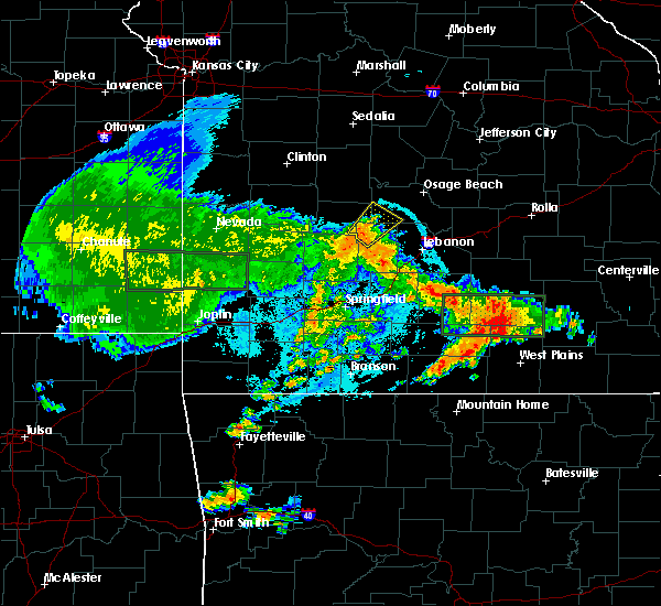 At 933 pm cdt, a severe thunderstorm was located near urbana, or 14 miles east of hermitage, moving northeast at 15 mph (radar indicated). Hazards include 60 mph wind gusts. Expect damage to roofs. siding. and trees. Locations impacted include, macks creek, tunas, branch, leadmine,. At 933 pm cdt, a severe thunderstorm was located near urbana, or 14 miles east of hermitage, moving northeast at 15 mph (radar indicated). Hazards include 60 mph wind gusts. Expect damage to roofs. siding. and trees. Locations impacted include, macks creek, tunas, branch, leadmine,.
|
| 6/23/2016 9:10 PM CDT |
 At 910 pm cdt, a severe thunderstorm was located near urbana, or 12 miles north of buffalo, moving northeast at 20 mph (radar indicated). Hazards include 60 mph wind gusts. Expect damage to roofs. siding. And trees. At 910 pm cdt, a severe thunderstorm was located near urbana, or 12 miles north of buffalo, moving northeast at 20 mph (radar indicated). Hazards include 60 mph wind gusts. Expect damage to roofs. siding. And trees.
|
| 6/16/2016 9:09 PM CDT |
 The severe thunderstorm warning for northern dallas, hickory, southwestern camden and southern benton counties will expire at 915 pm cdt, the storm which prompted the warning has weakened below severe limits, and no longer pose an immediate threat to life or property. therefore the warning will be allowed to expire. however gusty winds up to 50 mph, lightning, and heavy rain are still possible with this thunderstorm. The severe thunderstorm warning for northern dallas, hickory, southwestern camden and southern benton counties will expire at 915 pm cdt, the storm which prompted the warning has weakened below severe limits, and no longer pose an immediate threat to life or property. therefore the warning will be allowed to expire. however gusty winds up to 50 mph, lightning, and heavy rain are still possible with this thunderstorm.
|
| 6/16/2016 9:02 PM CDT |
 At 901 pm cdt, a severe thunderstorm was located 8 miles west of macks creek, or 10 miles east of hermitage, moving southeast at 15 mph (radar indicated. this storm has had a history of wind damage and hail up to the size of quarters near warsaw). Hazards include 60 mph wind gusts and nickel size hail. Expect damage to roofs. siding. and trees. Locations impacted include, pomme de terre lake, truman lake, lake of the ozarks, truman state park, pomme de terre state park, ha ha tonka state park, warsaw, pittsburg, hermitage, urbana, wheatland, macks creek, preston, cross timbers, climax springs, fristoe, tunas, branch, racket, whitakerville,. At 901 pm cdt, a severe thunderstorm was located 8 miles west of macks creek, or 10 miles east of hermitage, moving southeast at 15 mph (radar indicated. this storm has had a history of wind damage and hail up to the size of quarters near warsaw). Hazards include 60 mph wind gusts and nickel size hail. Expect damage to roofs. siding. and trees. Locations impacted include, pomme de terre lake, truman lake, lake of the ozarks, truman state park, pomme de terre state park, ha ha tonka state park, warsaw, pittsburg, hermitage, urbana, wheatland, macks creek, preston, cross timbers, climax springs, fristoe, tunas, branch, racket, whitakerville,.
|
| 6/16/2016 8:27 PM CDT |
 At 826 pm cdt, a severe thunderstorm was located 11 miles north of hermitage, moving southeast at 25 mph. this warning will replace the existing warning in the area (radar indicated). Hazards include 60 mph wind gusts and nickel size hail. Expect damage to roofs. siding. And trees. At 826 pm cdt, a severe thunderstorm was located 11 miles north of hermitage, moving southeast at 25 mph. this warning will replace the existing warning in the area (radar indicated). Hazards include 60 mph wind gusts and nickel size hail. Expect damage to roofs. siding. And trees.
|
| 6/15/2016 4:54 AM CDT | The severe thunderstorm warning for central dallas, laclede and southern camden counties will expire at 500 am cdt, the storms which prompted the warning have weakened below severe limits, and no longer pose an immediate threat to life or property. therefore the warning will be allowed to expire. however gusty winds and heavy rain are still possible with these thunderstorms. to report severe weather, contact your nearest law enforcement agency. they will relay your report to the national weather service springfield. |
| 6/15/2016 4:29 AM CDT |
 At 427 am cdt, severe thunderstorms were located along a line extending from near camdenton to 12 miles southeast of macks creek to 7 miles east of buffalo, moving east at 35 mph (radar indicated). Hazards include 60 mph wind gusts and penny size hail. Expect damage to roofs. siding. and trees. Locations impacted include, lebanon, lake of the ozarks, ha ha tonka state park, bennett spring state park, lake of the ozarks state park, camdenton, buffalo, richland, macks creek, linn creek, phillipsburg, stoutland, bennett springs, louisburg, twin bridges, tunas, branch, plad, decaturville, dry knob, this includes interstate 44 between mile markers 115 and 144. At 427 am cdt, severe thunderstorms were located along a line extending from near camdenton to 12 miles southeast of macks creek to 7 miles east of buffalo, moving east at 35 mph (radar indicated). Hazards include 60 mph wind gusts and penny size hail. Expect damage to roofs. siding. and trees. Locations impacted include, lebanon, lake of the ozarks, ha ha tonka state park, bennett spring state park, lake of the ozarks state park, camdenton, buffalo, richland, macks creek, linn creek, phillipsburg, stoutland, bennett springs, louisburg, twin bridges, tunas, branch, plad, decaturville, dry knob, this includes interstate 44 between mile markers 115 and 144.
|
| 6/15/2016 4:06 AM CDT |
 At 405 am cdt, severe thunderstorms were located along a line extending from 15 miles southwest of laurie to near macks creek to near buffalo, moving east at 35 mph (radar indicated). Hazards include 60 mph wind gusts and quarter size hail. Hail damage to vehicles is expected. Expect wind damage to roofs, siding, and trees. At 405 am cdt, severe thunderstorms were located along a line extending from 15 miles southwest of laurie to near macks creek to near buffalo, moving east at 35 mph (radar indicated). Hazards include 60 mph wind gusts and quarter size hail. Hail damage to vehicles is expected. Expect wind damage to roofs, siding, and trees.
|
| 4/26/2016 11:21 AM CDT |
 At 1120 am cdt, severe thunderstorms were located along a line extending from near california to 6 miles southeast of versailles to 13 miles west of laurie, moving southeast at 35 mph (trained weather spotters. multiple large trees have been reported down north of versailles in morgan county). Hazards include 60 mph wind gusts and half dollar size hail. Hail damage to vehicles is expected. expect wind damage to roofs, siding, and trees. locations impacted include, lake of the ozarks, lake of the ozarks state park, ha ha tonka state park, eldon, osage beach, camdenton, versailles, village of four seasons, lake ozark, stover, laurie, sunrise beach, st. Elizabeth, saint elizabeth, macks creek, linn creek, tuscumbia, barnett, eugene, gravois mills,. At 1120 am cdt, severe thunderstorms were located along a line extending from near california to 6 miles southeast of versailles to 13 miles west of laurie, moving southeast at 35 mph (trained weather spotters. multiple large trees have been reported down north of versailles in morgan county). Hazards include 60 mph wind gusts and half dollar size hail. Hail damage to vehicles is expected. expect wind damage to roofs, siding, and trees. locations impacted include, lake of the ozarks, lake of the ozarks state park, ha ha tonka state park, eldon, osage beach, camdenton, versailles, village of four seasons, lake ozark, stover, laurie, sunrise beach, st. Elizabeth, saint elizabeth, macks creek, linn creek, tuscumbia, barnett, eugene, gravois mills,.
|
| 4/26/2016 11:14 AM CDT |
 At 1113 am cdt, severe thunderstorms were located along a line extending from near california to near versailles to 12 miles east of warsaw, moving southeast at 35 mph (radar indicated. these storms do have a history of producing 60 mph winds in morgan county). Hazards include 60 mph wind gusts and half dollar size hail. Hail damage to vehicles is expected. Expect wind damage to roofs, siding, and trees. At 1113 am cdt, severe thunderstorms were located along a line extending from near california to near versailles to 12 miles east of warsaw, moving southeast at 35 mph (radar indicated. these storms do have a history of producing 60 mph winds in morgan county). Hazards include 60 mph wind gusts and half dollar size hail. Hail damage to vehicles is expected. Expect wind damage to roofs, siding, and trees.
|
| 7/24/2015 7:32 PM CDT |
 At 728 pm cdt, severe thunderstorms were located along a line extending from 11 miles northeast of hermitage to 10 miles south of camdenton, and moving south at 20 mph (law enforcement). Hazards include 60 mph wind gusts and nickel size hail. Expect damage to roofs. siding and trees. locations impacted include, camdenton, hermitage, lebanon, macks creek, urbana and wheatland. this warning also includes bennett spring state park, ha ha tonka state park, lake of the ozarks state park, lake of the ozarks, pomme de terre lake, pomme de terre state park and truman lake. Interstate 44 between mile markers 122 and 136 will also be impacted by severe thunderstorms. At 728 pm cdt, severe thunderstorms were located along a line extending from 11 miles northeast of hermitage to 10 miles south of camdenton, and moving south at 20 mph (law enforcement). Hazards include 60 mph wind gusts and nickel size hail. Expect damage to roofs. siding and trees. locations impacted include, camdenton, hermitage, lebanon, macks creek, urbana and wheatland. this warning also includes bennett spring state park, ha ha tonka state park, lake of the ozarks state park, lake of the ozarks, pomme de terre lake, pomme de terre state park and truman lake. Interstate 44 between mile markers 122 and 136 will also be impacted by severe thunderstorms.
|
| 7/24/2015 7:07 PM CDT |
 At 703 pm cdt, severe thunderstorms were located along a line extending from 19 miles northwest of macks creek to camdenton, and moving south at 20 mph (law enforcement. these storms have a history of downing trees and power lines). Hazards include 60 mph wind gusts and nickel size hail. Expect damage to roofs. Siding and trees. At 703 pm cdt, severe thunderstorms were located along a line extending from 19 miles northwest of macks creek to camdenton, and moving south at 20 mph (law enforcement. these storms have a history of downing trees and power lines). Hazards include 60 mph wind gusts and nickel size hail. Expect damage to roofs. Siding and trees.
|
| 7/24/2015 6:59 PM CDT |
 At 655 pm cdt, a severe thunderstorm was located near macks creek, and moving south at 15 mph (radar indicated). Hazards include 60 mph wind gusts and quarter size hail. Hail damage to vehicles is expected. expect wind damage to roofs, siding and trees. locations impacted include, branch, climax springs, eldridge, leadmine, macks creek, plad, pumpkin center, roach and tunas. This warning also includes ha ha tonka state park and lake of the ozarks. At 655 pm cdt, a severe thunderstorm was located near macks creek, and moving south at 15 mph (radar indicated). Hazards include 60 mph wind gusts and quarter size hail. Hail damage to vehicles is expected. expect wind damage to roofs, siding and trees. locations impacted include, branch, climax springs, eldridge, leadmine, macks creek, plad, pumpkin center, roach and tunas. This warning also includes ha ha tonka state park and lake of the ozarks.
|
| 7/24/2015 6:42 PM CDT |
 At 640 pm cdt, a severe thunderstorm was located near macks creek, and moving south at 15 mph (radar indicated). Hazards include 60 mph wind gusts and nickel size hail. Expect damage to roofs. Siding and trees. At 640 pm cdt, a severe thunderstorm was located near macks creek, and moving south at 15 mph (radar indicated). Hazards include 60 mph wind gusts and nickel size hail. Expect damage to roofs. Siding and trees.
|
| 7/1/2015 10:48 PM CDT |
 At 1045 pm cdt, severe thunderstorms were located along a line extending from 7 miles northwest of wheatland to 7 miles west of macks creek to 13 miles southeast of camdenton, and moving south at 35 mph (radar indicated). Hazards include 60 mph wind gusts and quarter size hail. Hail damage to vehicles is expected. Expect wind damage to roofs, siding and trees. At 1045 pm cdt, severe thunderstorms were located along a line extending from 7 miles northwest of wheatland to 7 miles west of macks creek to 13 miles southeast of camdenton, and moving south at 35 mph (radar indicated). Hazards include 60 mph wind gusts and quarter size hail. Hail damage to vehicles is expected. Expect wind damage to roofs, siding and trees.
|
| 7/1/2015 10:18 PM CDT |
 At 1016 pm cdt, severe thunderstorms were located along a line extending from osage beach to 13 miles northwest of macks creek to 9 miles southwest of warsaw, and moving south southeast at 25 mph (radar indicated). Hazards include 60 mph wind gusts and quarter size hail. Hail damage to vehicles is expected. expect wind damage to roofs, siding and trees. locations impacted include, camdenton, hermitage, lake ozark, laurie, macks creek, osage beach, village of four seasons, warsaw and wheatland. this warning also includes ha ha tonka state park, lake of the ozarks state park, lake of the ozarks, truman lake and truman state park. a tornado warning also remains in effect for southwestern benton and northern hickory counties. A tornado watch remains in effect until midnight cdt thursday morning for southeast kansas and southern missouri. At 1016 pm cdt, severe thunderstorms were located along a line extending from osage beach to 13 miles northwest of macks creek to 9 miles southwest of warsaw, and moving south southeast at 25 mph (radar indicated). Hazards include 60 mph wind gusts and quarter size hail. Hail damage to vehicles is expected. expect wind damage to roofs, siding and trees. locations impacted include, camdenton, hermitage, lake ozark, laurie, macks creek, osage beach, village of four seasons, warsaw and wheatland. this warning also includes ha ha tonka state park, lake of the ozarks state park, lake of the ozarks, truman lake and truman state park. a tornado warning also remains in effect for southwestern benton and northern hickory counties. A tornado watch remains in effect until midnight cdt thursday morning for southeast kansas and southern missouri.
|
| 7/1/2015 9:45 PM CDT |
 At 943 pm cdt, severe thunderstorms were located along a line extending from 10 miles northwest of laurie to 8 miles east of warsaw to 6 miles west of warsaw, and moving south at 25 mph (radar indicated). Hazards include 60 mph wind gusts and quarter size hail. Hail damage to vehicles is expected. Expect wind damage to roofs, siding and trees. At 943 pm cdt, severe thunderstorms were located along a line extending from 10 miles northwest of laurie to 8 miles east of warsaw to 6 miles west of warsaw, and moving south at 25 mph (radar indicated). Hazards include 60 mph wind gusts and quarter size hail. Hail damage to vehicles is expected. Expect wind damage to roofs, siding and trees.
|
| 7/1/2015 3:58 AM CDT |
 At 354 am cdt, severe thunderstorms were located along a line extending from camdenton to 13 miles southeast of urbana to 8 miles south of humansville to stockton, and moving south at 40 mph (radar indicated). Hazards include 60 mph wind gusts. Expect damage to roofs. siding and trees. locations impacted include, camdenton, hermitage, humansville, macks creek, stockton, urbana, weaubleau and wheatland. This warning also includes ha ha tonka state park, lake of the ozarks, pomme de terre lake, pomme de terre state park, stockton lake and truman lake. At 354 am cdt, severe thunderstorms were located along a line extending from camdenton to 13 miles southeast of urbana to 8 miles south of humansville to stockton, and moving south at 40 mph (radar indicated). Hazards include 60 mph wind gusts. Expect damage to roofs. siding and trees. locations impacted include, camdenton, hermitage, humansville, macks creek, stockton, urbana, weaubleau and wheatland. This warning also includes ha ha tonka state park, lake of the ozarks, pomme de terre lake, pomme de terre state park, stockton lake and truman lake.
|
| 7/1/2015 3:47 AM CDT |
 At 346 am cdt, severe thunderstorms were located along a line extending from 8 miles northwest of camdenton to 7 miles south of macks creek to humansville to 12 miles north of stockton, and moving southeast at 30 mph (radar indicated). Hazards include 60 mph wind gusts. Expect damage to roofs. siding and trees. locations impacted include, camdenton, hermitage, humansville, macks creek, osceola, stockton, urbana, weaubleau and wheatland. This warning also includes ha ha tonka state park, lake of the ozarks, pomme de terre lake, pomme de terre state park, stockton lake and truman lake. At 346 am cdt, severe thunderstorms were located along a line extending from 8 miles northwest of camdenton to 7 miles south of macks creek to humansville to 12 miles north of stockton, and moving southeast at 30 mph (radar indicated). Hazards include 60 mph wind gusts. Expect damage to roofs. siding and trees. locations impacted include, camdenton, hermitage, humansville, macks creek, osceola, stockton, urbana, weaubleau and wheatland. This warning also includes ha ha tonka state park, lake of the ozarks, pomme de terre lake, pomme de terre state park, stockton lake and truman lake.
|
| 7/1/2015 3:33 AM CDT |
 At 330 am cdt, severe thunderstorms were located along a line extending from 16 miles northwest of camdenton to macks creek to 9 miles west of weaubleau to 13 miles southwest of osceola, and moving southeast at 30 mph (radar indicated). Hazards include 60 mph wind gusts. Expect damage to roofs. Siding and trees. At 330 am cdt, severe thunderstorms were located along a line extending from 16 miles northwest of camdenton to macks creek to 9 miles west of weaubleau to 13 miles southwest of osceola, and moving southeast at 30 mph (radar indicated). Hazards include 60 mph wind gusts. Expect damage to roofs. Siding and trees.
|
| 6/28/2015 7:07 PM CDT |
 At 703 pm cdt, severe thunderstorms were located along a line extending from 7 miles northwest of richland to camdenton to 5 miles south of macks creek, and moving southeast at 35 mph (radar indicated. at 659 pm cdt...a trained spotter reported nickel to quarter sized hail one mile west of camdenton). Hazards include 60 mph wind gusts and quarter size hail. Hail damage to vehicles is expected. expect wind damage to roofs, siding and trees. locations impacted include, camdenton, lebanon, macks creek, northwestern fort leonard wood, richland, st. robert and waynesville. this warning also includes bennett spring state park, ha ha tonka state park, lake of the ozarks state park and lake of the ozarks. interstate 44 between mile markers 122 and 160 will also be impacted by severe thunderstorms. A severe thunderstorm watch remains in effect until 100 am cdt monday morning for southeast kansas and southern missouri. At 703 pm cdt, severe thunderstorms were located along a line extending from 7 miles northwest of richland to camdenton to 5 miles south of macks creek, and moving southeast at 35 mph (radar indicated. at 659 pm cdt...a trained spotter reported nickel to quarter sized hail one mile west of camdenton). Hazards include 60 mph wind gusts and quarter size hail. Hail damage to vehicles is expected. expect wind damage to roofs, siding and trees. locations impacted include, camdenton, lebanon, macks creek, northwestern fort leonard wood, richland, st. robert and waynesville. this warning also includes bennett spring state park, ha ha tonka state park, lake of the ozarks state park and lake of the ozarks. interstate 44 between mile markers 122 and 160 will also be impacted by severe thunderstorms. A severe thunderstorm watch remains in effect until 100 am cdt monday morning for southeast kansas and southern missouri.
|
| 6/28/2015 6:54 PM CDT |
 At 653 pm cdt, severe thunderstorms were located along a line extending from 11 miles east of camdenton to camdenton to macks creek, and moving southeast at 35 mph (radar indicated). Hazards include 60 mph wind gusts and quarter size hail. Hail damage to vehicles is expected. Expect wind damage to roofs, siding and trees. At 653 pm cdt, severe thunderstorms were located along a line extending from 11 miles east of camdenton to camdenton to macks creek, and moving southeast at 35 mph (radar indicated). Hazards include 60 mph wind gusts and quarter size hail. Hail damage to vehicles is expected. Expect wind damage to roofs, siding and trees.
|
| 6/26/2015 4:03 AM CDT |
 At 400 am cdt, severe thunderstorms were located along a line extending from laurie to 6 miles southwest of macks creek to 8 miles northeast of fair play to 9 miles west of stockton, and moving southeast at 40 mph (radar indicated). Hazards include 60 mph wind gusts and penny size hail. Expect damage to roofs. siding and trees. locations impacted include, el dorado springs, fair play, hermitage, humansville, laurie, macks creek, stockton, stover, urbana, versailles, village of four seasons, weaubleau and wheatland. This warning also includes ha ha tonka state park, lake of the ozarks, pomme de terre lake, pomme de terre state park, stockton lake, stockton state park and truman lake. At 400 am cdt, severe thunderstorms were located along a line extending from laurie to 6 miles southwest of macks creek to 8 miles northeast of fair play to 9 miles west of stockton, and moving southeast at 40 mph (radar indicated). Hazards include 60 mph wind gusts and penny size hail. Expect damage to roofs. siding and trees. locations impacted include, el dorado springs, fair play, hermitage, humansville, laurie, macks creek, stockton, stover, urbana, versailles, village of four seasons, weaubleau and wheatland. This warning also includes ha ha tonka state park, lake of the ozarks, pomme de terre lake, pomme de terre state park, stockton lake, stockton state park and truman lake.
|
| 6/26/2015 3:42 AM CDT |
 At 339 am cdt, severe thunderstorms were located along a line extending from 5 miles southwest of stover to 8 miles northeast of hermitage to 6 miles northwest of humansville to 9 miles southwest of el dorado springs, and moving southeast at 40 mph (trained weather spotters). Hazards include 70 mph wind gusts and penny size hail. these storms have a history of producing wind damage across central missouri. Expect considerable tree damage. damage is likely to mobile homes, roofs and outbuildings. locations impacted include, el dorado springs, fair play, hermitage, humansville, laurie, macks creek, sheldon, stockton, stover, urbana, versailles, village of four seasons, weaubleau and wheatland. This warning also includes ha ha tonka state park, lake of the ozarks, pomme de terre lake, pomme de terre state park, stockton lake, stockton state park and truman lake. At 339 am cdt, severe thunderstorms were located along a line extending from 5 miles southwest of stover to 8 miles northeast of hermitage to 6 miles northwest of humansville to 9 miles southwest of el dorado springs, and moving southeast at 40 mph (trained weather spotters). Hazards include 70 mph wind gusts and penny size hail. these storms have a history of producing wind damage across central missouri. Expect considerable tree damage. damage is likely to mobile homes, roofs and outbuildings. locations impacted include, el dorado springs, fair play, hermitage, humansville, laurie, macks creek, sheldon, stockton, stover, urbana, versailles, village of four seasons, weaubleau and wheatland. This warning also includes ha ha tonka state park, lake of the ozarks, pomme de terre lake, pomme de terre state park, stockton lake, stockton state park and truman lake.
|
| 6/26/2015 3:26 AM CDT |
 At 323 am cdt, severe thunderstorms were located along a line extending from 11 miles west of stover to 13 miles north of wheatland to 13 miles northeast of el dorado springs to 17 miles west of el dorado springs, and moving southeast at 40 mph (law enforcement). Hazards include 70 mph wind gusts and penny size hail. these storms have a history of producing wind damage across central missouri. Expect considerable tree damage. Damage is likely to mobile homes, roofs and outbuildings. At 323 am cdt, severe thunderstorms were located along a line extending from 11 miles west of stover to 13 miles north of wheatland to 13 miles northeast of el dorado springs to 17 miles west of el dorado springs, and moving southeast at 40 mph (law enforcement). Hazards include 70 mph wind gusts and penny size hail. these storms have a history of producing wind damage across central missouri. Expect considerable tree damage. Damage is likely to mobile homes, roofs and outbuildings.
|
| 5/17/2015 2:33 AM CDT | At 231 am cdt, severe thunderstorms were located along a line extending from 19 miles west of laurie to 20 miles west of conway, and moving east at 50 mph. these storms have a history of producing wind damage (radar indicated). Hazards include 60 mph wind gusts and penny size hail. Expect damage to roofs. Siding and trees. |
| 4/13/2014 7:25 PM CDT | Small 10 ft tall tree downe in camden county MO, 0.3 miles SSW of Macks Creek, MO |
| 5/20/2013 8:04 PM CDT | Damage to siding and shingles to a couple hotels near white water par in camden county MO, 4.1 miles NNE of Macks Creek, MO |
| 1/1/0001 12:00 AM | Quarter sized hail reported 3.4 miles W of Macks Creek, MO, quarter size hail reported at the intersection of highway 54 and highway j. |
| 1/1/0001 12:00 AM | Storm spotter measured 75 mph wind gust in camden county MO, 0.3 miles SSW of Macks Creek, MO |
| 1/1/0001 12:00 AM | Storm spotter measured 75 mph wind gust in camden county MO, 0.3 miles SSW of Macks Creek, MO |
| 1/1/0001 12:00 AM | Golf Ball sized hail reported 0.3 miles SSW of Macks Creek, MO |
| 1/1/0001 12:00 AM | Quarter sized hail reported 3.8 miles E of Macks Creek, MO |
| 1/1/0001 12:00 AM | Golf Ball sized hail reported 0.3 miles SSW of Macks Creek, MO, just southeast of macks creek. |
Hail Maps for Macks Creek, MO


Connect with Interactive Hail Maps