

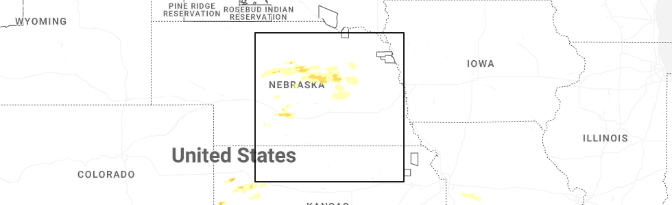
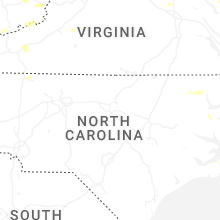
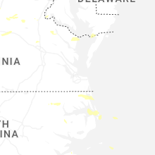
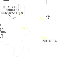
Hail Map for Friday, June 12, 2026
Number of Impacted Households on 6/12/2026
0
Impacted by 1" or Larger Hail
0
Impacted by 1.75" or Larger Hail
0
Impacted by 2.5" or Larger Hail
Square Miles of Populated Area Impacted on 6/12/2026
0
Impacted by 1" or Larger Hail
0
Impacted by 1.75" or Larger Hail
0
Impacted by 2.5" or Larger Hail
Cities Most Affected by Hail Storms of 6/12/2026
| Hail Size | Demographics of Zip Codes Affected | ||||||
|---|---|---|---|---|---|---|---|
| City | Count | Average | Largest | Pop Density | House Value | Income | Age |
| Burwell, NE | 1 | 2.75 | 2.75 | 1 | $39k | $26.8k | 50.4 |
| Tribune, KS | 1 | 1.75 | 1.75 | 1 | $58k | $34.3k | 46.6 |
| Elkhart, KS | 1 | 1.75 | 1.75 | 2 | $83k | $49.2k | 38.3 |
| Bethany, MO | 1 | 1.75 | 1.75 | 25 | $61k | $29.1k | 40.9 |
Hail and Wind Damage Spotted on 6/12/2026
Filter by Report Type:Hail ReportsWind Reports
States Impacted
Arkansas, Missouri, Alabama, West Virginia, New York, Virginia, Pennsylvania, New Jersey, Montana, Maryland, South Carolina, Vermont, Georgia, North Carolina, Connecticut, Maine, Kansas, New Mexico, Oklahoma, Texas, NebraskaArkansas
| Local Time | Report Details |
|---|---|
| 7:15 AM CDT | Department of transportation reported 1 downed tree blocking us 70 in sevier county 2 miles west of dequeen. winds estimated 50 mp in sevier county AR, 31.3 miles WNW of Nashville, AR |
| 7:25 AM CDT | Department of transportation reported 1 downed tree blocking ar 24 in sevier county 1 mile west if lockesburg. winds estimated 50 mp in sevier county AR, 20.3 miles W of Nashville, AR |
| 7:31 AM CDT | Department of transportation reported 1 downed tree blocking us 278 in howard county 2 miles southeast of dierks. winds estimated 50 mp in howard county AR, 14.4 miles NW of Nashville, AR |
| 5:58 PM CDT | Large limb blown down onto the roof of a hom in lonoke county AR, 20.2 miles E of Little Rock, AR |
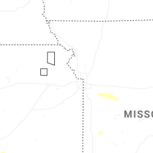
Missouri
| Local Time | Report Details |
|---|---|
| 7:24 AM CDT | Half Dollar sized hail reported near Grant City, MO, 86.5 miles SSW of Des Moines, IA, social media report. time estimated from radar. |
| 9:28 AM CDT | Golf Ball sized hail reported near Bethany, MO, 86.5 miles NNE of Kansas City, MO, hail to the size of golf balls damaged several windows of a residence and stripped leaves and limbs from multiple trees. time estimated from radar. |
Alabama
| Local Time | Report Details |
|---|---|
| 10:41 AM CDT | A tree was knocked down into the roadway at 957 cr 177. time estimated by rada in lauderdale county AL, 15.2 miles NNE of Florence, AL |
| 11:02 AM CDT | A tree was knocked down into the roadway at 2300 cr 103. time estimated by rada in lauderdale county AL, 11.7 miles ENE of Florence, AL |
| 1:20 PM CDT | A tree was knocked down into the roadway at 7500 al highway 71. time estimated by rada in jackson county AL, 42.4 miles SW of Chattanooga, TN |
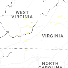
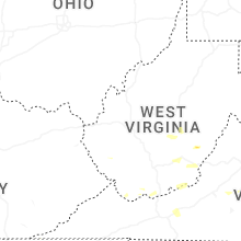
West Virginia
| Local Time | Report Details |
|---|---|
| 2:30 PM EDT | Tree and lines down on loghouse rd off of short creek rd. time estimated from rada in boone county WV, 13.1 miles S of Charleston, WV |
| 2:50 PM EDT | Tree down blocking price hollow rd near ashford nellis rd. time estimated from rada in boone county WV, 11.9 miles S of Charleston, WV |
| 3:10 PM EDT | Power outages due to tree damage. time estimated based on rada in nicholas county WV, 46.1 miles E of Charleston, WV |
| 3:20 PM EDT | Multiple tree contacts and several dozen customers without powe in raleigh county WV, 30.1 miles SSE of Charleston, WV |
| 3:25 PM EDT | Power outages due to tree damage. time estimated based on rada in nicholas county WV, 51.6 miles E of Charleston, WV |
| 3:35 PM EDT | Quarter sized hail reported near Mount Nebo, WV, 44.1 miles ESE of Charleston, WV, picture provided. time estimated from radar. |
| 3:48 PM EDT | Several areas of power outages due to tree/line damage. time estimated based on rada in nicholas county WV, 56.7 miles SW of Elkins, WV |
| 3:55 PM EDT | Over 260 customers without power with tree damage as the caus in fayette county WV, 48.3 miles SE of Charleston, WV |
| 3:56 PM EDT | Tree down across white oak road. time is estimated by rada in fayette county WV, 48.4 miles ESE of Charleston, WV |
| 4:10 PM EDT | Several trees down... likely one large tree brought all of them down. time estimated based on rada in mcdowell county WV, 65.5 miles SSE of Charleston, WV |
| 4:21 PM EDT | A tree fell on a house (no injuries). time is estimated by rada in raleigh county WV, 45.7 miles SSE of Charleston, WV |
| 4:40 PM EDT | Tree down at the intersection of sam anderson road and dyer lane in greenbrier county west virgini in greenbrier county WV, 50 miles NW of Roanoke, VA |
| 4:40 PM EDT | Large limbs dow in mercer county WV, 69.5 miles W of Roanoke, VA |
| 4:43 PM EDT | Tree down at the intersection of renick avenue... and chesapeake street & walnut hill in greenbrier county west virgini in greenbrier county WV, 44.5 miles NW of Roanoke, VA |
| 4:45 PM EDT | Tree downed by thunderstorm winds in the 300 block of goheen street... and landed across the roadwa in greenbrier county WV, 44.9 miles NW of Roanoke, VA |
| 4:51 PM EDT | Tree on power lines on cr-84 (1700 blk of anawalt ridge rd) in anawalt. time estimated based on rada in mcdowell county WV, 67.3 miles NE of Bristol, TN |
| 4:53 PM EDT | Tree downed by thunderstorm winds in the 10500 block of highland trail... near the intersection of grandview drive and hillcrest driv in greenbrier county WV, 44.4 miles NW of Roanoke, VA |
| 4:55 PM EDT | Tree downed by thunderstorm winds in the 500 block of pocahontas avenue... and blocked the entire roadwa in greenbrier county WV, 44 miles NW of Roanoke, VA |
| 4:55 PM EDT | Tree down... wires down. time estimated based on rada in mcdowell county WV, 68.6 miles NE of Bristol, TN |
| 4:55 PM EDT | Tree down. time estimated based on rada in mcdowell county WV, 70 miles NE of Bristol, TN |
| 4:56 PM EDT | 643 customers without power from storm damage. time estimated based on rada in mcdowell county WV, 66.5 miles NE of Bristol, TN |
| 5:15 PM EDT | Several trees downed on route 20 near pump house roa in mercer county WV, 60 miles WNW of Roanoke, VA |
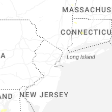
New York
| Local Time | Report Details |
|---|---|
| 3:30 PM EDT | Three reports from various sources from broadcast media to county call center indicate an isolated area of town had trees down and a roof on a salt shed that had an ope in washington county NY, 47 miles NE of Schenectady, NY |
| 7:03 PM EDT | Tree snapped in on 73rd place near metropolitan avenu in queens county NY, 5.9 miles ENE of Brooklyn, NY |
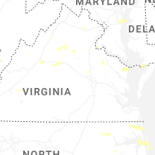
Virginia
| Local Time | Report Details |
|---|---|
| 3:33 PM EDT | Dispatch reported numerous downed tree in lee county VA, 53.1 miles NNE of Knoxville, TN |
| 4:02 PM EDT | Tree down reported at cabin branch road and cliff mills roa in fauquier county VA, 80.6 miles WSW of Baltimore, MD |
| 4:20 PM EDT | Tree down reported near bear wallow roa in fauquier county VA, 75.9 miles WSW of Baltimore, MD |
| 4:25 PM EDT | Tree down reported at richards ferry road and beach roa in culpeper county VA, 61.8 miles N of Richmond, VA |
| 4:30 PM EDT | Power outages due to storm damage. time estimated based on rada in buchanan county VA, 53 miles NNE of Bristol, TN |
| 4:43 PM EDT | Quarter sized hail reported near Haymarket, VA, 63.3 miles WSW of Baltimore, MD |
| 4:45 PM EDT | Tree reported on roadway near hazel grov in spotsylvania county VA, 55.6 miles N of Richmond, VA |
| 4:45 PM EDT | A large tree was down along ingleside drive and washington stree in stafford county VA, 57.2 miles N of Richmond, VA |
| 5:06 PM EDT | Multiple reports of trees and power lines down near linden ave in the city of fredericksbur in city of fredericks county VA, 55.6 miles N of Richmond, VA |
| 5:07 PM EDT | Multiple reports of fallen trees near winchester street in city of fredericksbur in city of fredericks county VA, 55.8 miles N of Richmond, VA |
| 5:15 PM EDT | Multiple trees downed onto woodford road in woodford. time radar-estimate in caroline county VA, 44.7 miles NNE of Richmond, VA |
| 5:28 PM EDT | Reports of multiple trees down across the area in spotsylvania c in spotsylvania county VA, 48.1 miles N of Richmond, VA |
| 5:28 PM EDT | Trees down near sherman road in woodstoc in shenandoah county VA, 69.2 miles E of Elkins, WV |
| 5:28 PM EDT | Tree down near brown farms roa in spotsylvania county VA, 50.9 miles N of Richmond, VA |
| 5:29 PM EDT | Tree down and covering both lanes on big stoney creek road in ripplemea in giles county VA, 37 miles WNW of Roanoke, VA |
| 5:30 PM EDT | Large tree branch downed by thunderstorm winds... and brought down a power line which landed across the roa in alleghany county VA, 35.1 miles N of Roanoke, VA |
| 5:37 PM EDT | Multiple trees down near woodstock at w high street and s lee stree in shenandoah county VA, 72 miles E of Elkins, WV |
| 5:40 PM EDT | Reports of multiple trees down across the area in spotsylvania c in spotsylvania county VA, 38.4 miles N of Richmond, VA |
| 5:45 PM EDT | Social media post of multiple trees snapped in half on the galax municipal golf course in galax virgini in city of galax county VA, 67.4 miles SW of Roanoke, VA |
| 5:50 PM EDT | Multiple reports of trees down across southern madison c in madison county VA, 65.7 miles NNW of Richmond, VA |
| 5:55 PM EDT | Multiple trees and branches down near cee cee turner trail and broadwa in rockingham county VA, 60.4 miles ESE of Elkins, WV |
| 6:00 PM EDT | A few trees and power lines reported down across stuarts draft are in augusta county VA, 72.3 miles NE of Roanoke, VA |
| 6:00 PM EDT | Trees down in bumpass. time estimated from rada in louisa county VA, 31.8 miles N of Richmond, VA |
| 6:04 PM EDT | Tree down at route 29 and carpenters mill roa in greene county VA, 62.9 miles NW of Richmond, VA |
| 6:04 PM EDT | One tree down due to thunderstorm winds along hall school roa in augusta county VA, 74.7 miles NE of Roanoke, VA |
| 6:05 PM EDT | One tree down due to thunderstorm winds at the intersection of china clay road and patton farm roa in augusta county VA, 72.9 miles NE of Roanoke, VA |
| 6:05 PM EDT | One tree down due to thunderstorm winds along the 900 block of howardsville turnpik in augusta county VA, 72 miles NE of Roanoke, VA |
| 6:06 PM EDT | One tree down due to thunderstorm winds at the intersection of lyndhurst road and schages lan in augusta county VA, 73.3 miles NE of Roanoke, VA |
| 6:09 PM EDT | Large tree down at endless caverns roa in rockingham county VA, 66.2 miles ESE of Elkins, WV |
| 6:10 PM EDT | One tree down due to thunderstorm winds at the intersection of misty hill lane and rockfish roa in augusta county VA, 77.2 miles SE of Elkins, WV |
| 6:12 PM EDT | Tree downed by thunderstorm winds on interstate 81 near mile marker 136. in city of salem county VA, 10 miles W of Roanoke, VA |
| 6:15 PM EDT | Tree downed by thunderstorm winds and then fell onto a power lin in pulaski county VA, 47.5 miles WSW of Roanoke, VA |
| 6:15 PM EDT | Lightning struck a tree... which then fell onto a power line near meadow view apartment in pulaski county VA, 48 miles WSW of Roanoke, VA |
| 6:18 PM EDT | A few trees were downed by thunderstorm winds in the town of pulask in pulaski county VA, 48.3 miles WSW of Roanoke, VA |
| 6:18 PM EDT | Tree downed by thunderstorm winds onto a power lin in city of roanoke county VA, 3.3 miles N of Roanoke, VA |
| 6:19 PM EDT | Several trees were downed by thunderstorm winds in the town of drape in pulaski county VA, 47.9 miles WSW of Roanoke, VA |
| 6:20 PM EDT | Trees downed along i-95 at mile marker 113 southboun in caroline county VA, 38.6 miles NNE of Richmond, VA |
| 6:25 PM EDT | Large tree branches downed onto ladysmith road at us-1. time radar-estimate in caroline county VA, 36.4 miles NNE of Richmond, VA |
| 6:26 PM EDT | Power line downed by thunderstorm winds caught a nearby tree on fire on hollyhock road n in city of roanoke county VA, 3.4 miles N of Roanoke, VA |
| 6:29 PM EDT | Tree downed by thunderstorm winds onto a power line on 15th street n in city of roanoke county VA, 1.7 miles NE of Roanoke, VA |
| 6:29 PM EDT | Large tree downed by thunderstorm winds... blocking the entire road... and hit a nearby power pol in city of roanoke county VA, 1.1 miles E of Roanoke, VA |
| 6:32 PM EDT | Outflow winds from thunderstorms blew a tree down in the 200 block of sample road. the tree completely blocked the roa in franklin county VA, 12.8 miles SSE of Roanoke, VA |
| 6:35 PM EDT | Trees downed at south church ln. time radar-estimate in essex county VA, 52.4 miles NE of Richmond, VA |
| 6:36 PM EDT | Several trees down along route 50 near middlebur in loudoun county VA, 64.1 miles WSW of Baltimore, MD |
| 6:40 PM EDT | *** 1 fatal... 23 inj *** corrects previous tstm wnd dmg report from 2 s moneta. outflow from thunderstorm blew down one tent at a local church. one fatality and 23 inj in bedford county VA, 19.1 miles ESE of Roanoke, VA |
| 6:40 PM EDT | Virginia tech mesonet in middleburg in fauquier county VA, 65.1 miles WSW of Baltimore, MD |
| 6:45 PM EDT | Trees downed on scotchtown rd south of chiswell l in hanover county VA, 22.8 miles N of Richmond, VA |
| 6:45 PM EDT | Social media picture shows tree down across cedarberry lane in forest... v in bedford county VA, 35.1 miles ENE of Roanoke, VA |
| 6:52 PM EDT | Trees reported down along thomas jefferson parkwa in albemarle county VA, 49.6 miles NW of Richmond, VA |
| 6:53 PM EDT | Storm damage reported in fairfax county VA, 51.2 miles WSW of Baltimore, MD |
| 6:56 PM EDT | Multiple reports of trees and powerlines down in far western louisa county... particularly near troy. there is also a large cluster of power outage in fluvanna county VA, 46 miles NW of Richmond, VA |
| 7:02 PM EDT | Tree down at alder woods drive and joseph seiwick driv in fairfax county VA, 50.2 miles SW of Baltimore, MD |
| 7:04 PM EDT | Tree down at vale road and vale station roa in fairfax county VA, 49.7 miles SW of Baltimore, MD |
| 7:09 PM EDT | Large tree downed by thunderstorm winds on bateman ridge road. report on social medi in bedford county VA, 37.4 miles E of Roanoke, VA |
| 7:12 PM EDT | Tree down near lomand dr and urbanna roa in prince william county VA, 59.5 miles SW of Baltimore, MD |
| 7:20 PM EDT | Large trees downed on wharf rd and essex mill at tidewater r in essex county VA, 51.8 miles ENE of Richmond, VA |
| 7:30 PM EDT | Large tree downed at intersection of weems rd and christ church r in lancaster county VA, 67.5 miles NNW of Virginia Beach, VA |
| 7:55 PM EDT | Large tree branch down in reedville in northumberland county... v in northumberland county VA, 73.1 miles WSW of Ocean City, MD |
| 8:38 PM EDT | Power lines dow in city of norfolk county VA, 13.8 miles NW of Virginia Beach, VA |
| 8:48 PM EDT | Corrects previous tstm wnd gst report from 3 ne bayside. 52 kt gust at mesonet station xlhi lynnhaven inlet light in anz634 county VA, 11.5 miles N of Virginia Beach, VA |
| 9:09 PM EDT | Measured via handheld anemomete in dinwiddie county VA, 17 miles S of Richmond, VA |
| 9:12 PM EDT | Trees and powerlines dow in dinwiddie county VA, 21.7 miles S of Richmond, VA |
| 9:30 PM EDT | Asos station kwal wallops islan in accomack county VA, 35 miles SW of Ocean City, MD |
| 9:30 PM EDT | Multiple trees down near the intersection of horsey rd and neal park road and near arcadia high school. time estimated from rada in accomack county VA, 38.8 miles SW of Ocean City, MD |
| 10:00 PM EDT | Multiple trees down in new church in accomack county. time estimated from rada in accomack county VA, 34.5 miles SW of Ocean City, MD |
Pennsylvania
| Local Time | Report Details |
|---|---|
| 3:37 PM EDT | Corrects previous tstm wnd dmg report from montrose. trees down blocking roads in several location in susquehanna county PA, 31.1 miles NNW of Scranton, PA |
| 3:37 PM EDT | Corrects previous tstm wnd dmg report from montrose. trees down blocking roads in several location in susquehanna county PA, 31.1 miles NNW of Scranton, PA |
| 3:41 PM EDT | Trees dow in susquehanna county PA, 32.6 miles N of Scranton, PA |
New Jersey
| Local Time | Report Details |
|---|---|
| 4:21 PM EDT | Trees down in readington township. time estimated from rada in hunterdon county NJ, 43.5 miles WSW of Brooklyn, NY |
| 4:21 PM EDT | Corrects previous tstm wnd dmg report from 2 sse raritan twp. trees down in raritan township. time estimated from rada in hunterdon county NJ, 48.3 miles WSW of Brooklyn, NY |
| 4:28 PM EDT | Multiple trees down on branin road in medford. time estimated from rada in burlington county NJ, 70.3 miles SW of Brooklyn, NY |
| 4:46 PM EDT | Wires down near big hill road in southampton township. time estimated from rada in burlington county NJ, 66.3 miles SW of Brooklyn, NY |
| 4:50 PM EDT | Tree down at sooy place road and south park road in tabernacle. time estimated from rada in burlington county NJ, 66.6 miles SSW of Brooklyn, NY |
| 6:19 PM EDT | Trees uprooted reported by mpin in bergen county NJ, 23.6 miles NNW of Brooklyn, NY |
| 6:20 PM EDT | Tree down onto a home on forest av in bergen county NJ, 25.6 miles NNW of Brooklyn, NY |
| 6:20 PM EDT | Large tree down blocking summit avenu in bergen county NJ, 23.6 miles NNW of Brooklyn, NY |
| 6:40 PM EDT | Several trees reported down across the cit in bergen county NJ, 14 miles NNW of Brooklyn, NY |
| 6:40 PM EDT | Tree down on prospect ave and arlington blvd. there are also power lines done in the same are in bergen county NJ, 10.3 miles NW of Brooklyn, NY |
| 6:40 PM EDT | Multiple reports and photos of large trees down on poplar and fairmount avenue near summit avenue. several on homes causing damag in bergen county NJ, 15.3 miles NNW of Brooklyn, NY |
Montana
| Local Time | Report Details |
|---|---|
| 2:25 PM MDT | Quarter sized hail reported near Fairfield, MT, 32.3 miles WNW of Great Falls, MT, hail around quarter size fell this afternoon. some tree damage. |
| 5:40 PM MDT | Awos station k1cm charlie. 63 mph thunderstorm wind gus in judith basin county MT, 60.3 miles ESE of Great Falls, MT |
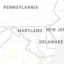
Maryland
| Local Time | Report Details |
|---|---|
| 4:30 PM EDT | Trained spotter reported downed tree blocking road at ormond road and counselman roa in montgomery county MD, 36.8 miles WSW of Baltimore, MD |
| 7:38 PM EDT | One tree down along waveland farm road near governor ritchie highwa in anne arundel county MD, 21.2 miles SSE of Baltimore, MD |
| 8:39 PM EDT | Tree down riverside road and winchester roa in anne arundel county MD, 19.4 miles SSE of Baltimore, MD |
| 8:40 PM EDT | Storm damage reported in anne arundel county MD, 19.7 miles SSE of Baltimore, MD |
| 8:42 PM EDT | Multiple reports of trees down near huntingtown... md due to thunderstorm in calvert county MD, 46.9 miles S of Baltimore, MD |
| 8:42 PM EDT | Multiple reports of trees down near prince frederick... md due to thunderstorm in calvert county MD, 51.8 miles S of Baltimore, MD |
| 8:42 PM EDT | Tree down at german chapel rd and solomons island roa in calvert county MD, 53.9 miles S of Baltimore, MD |
| 8:42 PM EDT | Tree down in 400 block along halsey roa in anne arundel county MD, 21.3 miles SSE of Baltimore, MD |
| 8:42 PM EDT | Multiple trees down along generals highwa in anne arundel county MD, 18.7 miles S of Baltimore, MD |
| 8:44 PM EDT | Bay bridge wxflow sit in queen anne's county MD, 26.2 miles SE of Baltimore, MD |
| 8:44 PM EDT | Storm damage reported in anne arundel county MD, 21.8 miles S of Baltimore, MD |
| 8:44 PM EDT | Storm damage reported in anz532 county MD, 25.3 miles SE of Baltimore, MD |
| 8:52 PM EDT | Widespread reports of trees and wires down across the northern portion of kent island. time estimated from rada in queen anne's county MD, 25.7 miles SE of Baltimore, MD |
| 9:03 PM EDT | Storm damage reported in anne arundel county MD, 21.8 miles SSE of Baltimore, MD |
| 9:04 PM EDT | Storm damage reported in anne arundel county MD, 21.8 miles SSE of Baltimore, MD |
| 9:04 PM EDT | Storm damage reported in anz532 county MD, 25.3 miles SE of Baltimore, MD |
| 9:45 PM EDT | Damaged transformer on e church st in salisbury... md. time estimated from rada in wicomico county MD, 28.1 miles W of Ocean City, MD |
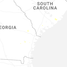
South Carolina
| Local Time | Report Details |
|---|---|
| 4:36 PM EDT | A 911 call center reported a tree down along copperhead r in berkeley county SC, 12.4 miles ESE of Charleston, SC |
| 4:36 PM EDT | A 911 call center reported a tree down along wading point blv in berkeley county SC, 17.3 miles SE of Charleston, SC |
Vermont
| Local Time | Report Details |
|---|---|
| 5:10 PM EDT | Tree down on osgood hill rd. time estimated by rada in chittenden county VT, 11.3 miles ENE of Burlington, VT |
Georgia
| Local Time | Report Details |
|---|---|
| 6:15 PM EDT | A 911 call center reported a tree down along hwy 67 near barn r in bulloch county GA, 34.6 miles WNW of Savannah, GA |
| 6:15 PM EDT | Public reported a tree down near the intersection of rolling hills rd and walter mcglammery r in bulloch county GA, 53.1 miles NW of Savannah, GA |
| 6:32 PM EDT | Public reported downed trees along 5 chop roa in bulloch county GA, 42.9 miles NW of Savannah, GA |
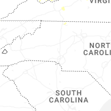
North Carolina
| Local Time | Report Details |
|---|---|
| 6:24 PM EDT | Thunderstorm winds blew a tree down between the 1500 and 1600 blocks of sheep farm road. the tree blocked both lanes of trave in surry county NC, 67.4 miles SSW of Roanoke, VA |
| 6:39 PM EDT | Multiple trees on road and powerlines dow in caldwell county NC, 58.7 miles SE of Bristol, TN |
| 6:56 PM EDT | Multiple trees down on roa in caldwell county NC, 56.1 miles SE of Bristol, TN |
| 7:02 PM EDT | Half Dollar sized hail reported near Hendersonville, NC, 34.6 miles N of Greenville, SC |
| 7:06 PM EDT | Thunderstorm winds blew a tree down in the 100 block of mountain view roa in surry county NC, 66.3 miles SW of Roanoke, VA |
| 7:07 PM EDT | Thunderstorm winds blew a tree down in the 1500 block of edgewood driv in surry county NC, 66.9 miles SW of Roanoke, VA |
| 7:07 PM EDT | Thunderstorm winds blew a tree down in the 600 block of south andy griffith parkwa in surry county NC, 65.7 miles SW of Roanoke, VA |
| 7:09 PM EDT | Several trees downed by thunderstorm winds on s andy griffith parkway... near the railroad crossin in surry county NC, 66 miles SW of Roanoke, VA |
| 7:09 PM EDT | Tree downed by thunderstorm winds and landed on a car near the walmart in mount air in surry county NC, 66.9 miles SW of Roanoke, VA |
| 7:12 PM EDT | Thunderstorm winds blew a tree down in the 100 block of bridgeport roa in surry county NC, 65.4 miles SSW of Roanoke, VA |
| 7:12 PM EDT | Tree downed by thunderstorm winds and landed in the roadway on arlington stree in surry county NC, 65.7 miles SW of Roanoke, VA |
| 7:14 PM EDT | Tree downed by thunderstorm winds and landed on a power lin in surry county NC, 62.2 miles SSW of Roanoke, VA |
| 7:15 PM EDT | Thunderstorm winds blew a tree down near the intersection of massey road and st marie trail. the tree fell on a powerline and a truck with occupants. none of the occupa in surry county NC, 64.8 miles SSW of Roanoke, VA |
| 7:17 PM EDT | Thunderstorm winds blew a tree down in the 3100 block of westfield road. the tree blocked both lane in surry county NC, 63.3 miles SSW of Roanoke, VA |
| 7:17 PM EDT | Thunderstorm winds blew a tree down in the 100 block of gilda driv in surry county NC, 64.8 miles SSW of Roanoke, VA |
| 7:24 PM EDT | Corrects time of previous tstm wnd dmg report from 2 e white plains. thunderstorm winds blew a tree down between the 1500 and 1600 blocks of sheep farm road. tree block in surry county NC, 67.4 miles SSW of Roanoke, VA |
| 12:27 AM EDT | Delayed repor in dare county NC, 65.4 miles SSE of Virginia Beach, VA |
Connecticut
| Local Time | Report Details |
|---|---|
| 6:42 PM EDT | Report of branch/tree down on w churchill r in litchfield county CT, 73.7 miles NNE of Brooklyn, NY |
| 6:54 PM EDT | Large tree and large tree limbs down near main st. in watertown. report from faceboo in litchfield county CT, 77.4 miles NE of Brooklyn, NY |
| 6:56 PM EDT | Trees down in wires on ct-262 and echo lake rd with all lanes close in litchfield county CT, 78.8 miles NE of Brooklyn, NY |
| 7:02 PM EDT | Tree limbs down causing a power outage near kramer av in new haven county CT, 78 miles NE of Brooklyn, NY |
Maine
| Local Time | Report Details |
|---|---|
| 6:46 PM EDT | Delayed report. one tree down partially blocking tenney hill road. time estimated by rada in piscataquis county ME, 40.3 miles NW of Bangor, ME |
| 7:45 PM EDT | Fire department reports large trees down... a 14 in diameter tree... and a 2 ft diameter tre in piscataquis county ME, 40.8 miles NNW of Bangor, ME |
| 7:45 PM EDT | Fire department reports trees down on quarry road with 3-8 in diamete in piscataquis county ME, 38.5 miles NNW of Bangor, ME |
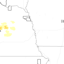
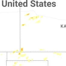
Kansas
| Local Time | Report Details |
|---|---|
| 8:07 PM CDT | Golf Ball sized hail reported near Elkhart, KS, 87.5 miles SW of Garden City, KS |
| 8:14 PM CDT | Quarter sized hail reported near Elkhart, KS, 87.5 miles SW of Garden City, KS |
| 8:22 PM CDT | Quarter sized hail reported near Richfield, KS, 78 miles SW of Garden City, KS |
| 8:05 PM MDT | Golf Ball sized hail reported near Tribune, KS, 67 miles SW of Colby, KS, social media report of dime sized hail with a few golf ball sized as well. |
| 11:59 PM CDT | Asos station kddc dodge city regional airpor in ford county KS, 51.2 miles ESE of Garden City, KS |
| 12:00 AM CDT | Storm damage reported in ford county KS, 51.6 miles ESE of Garden City, KS |
| 12:25 AM CDT | Storm damage reported in ford county KS, 51.6 miles ESE of Garden City, KS |
| 12:45 AM CDT | Storm damage reported in ford county KS, 60.4 miles ESE of Garden City, KS |
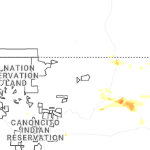
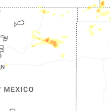
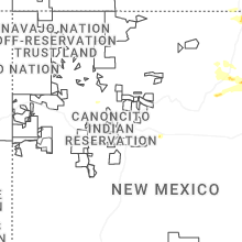
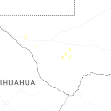
New Mexico
| Local Time | Report Details |
|---|---|
| 7:22 PM MDT | Half Dollar sized hail reported near Roy, NM, 59.4 miles NNW of Tucumcari, NM |
| 8:07 PM MDT | Quarter sized hail reported near Moriarty, NM, 30.3 miles ESE of Albuquerque, NM, thunderstorm wind damage as well blowing off the roof of their barn. |
| 8:07 PM MDT | Thunderstorm wind damage as well blowing off the roof of their bar in torrance county NM, 30.3 miles ESE of Albuquerque, NM |
| 8:07 PM MDT | Thunderstorm wind damage as well blowing off the roof of their bar in torrance county NM, 30.3 miles ESE of Albuquerque, NM |
| 8:15 PM MDT | Mesonet station 68nmc rosebud 7n in harding county NM, 50.3 miles NNE of Tucumcari, NM |
Oklahoma
| Local Time | Report Details |
|---|---|
| 9:10 PM CDT | Thunderstorm wind gust of 96 mph measured at the oklahoma mesonet site 11 miles ne of ev in texas county OK, 87.9 miles SW of Garden City, KS |
| 9:35 PM CDT | Thunderstorm wind gust of 59 mph measured at 11 miles northeast of eva... ok at 9:35 p in texas county OK, 87.9 miles SW of Garden City, KS |
| 1:15 AM CDT | Mesonet station mayr may ranc in woods county OK, 44 miles NNE of Woodward, OK |
| 2:55 AM CDT | Powerlines downed. winds estimated around 50 to 60 mp in garfield county OK, 78.5 miles NNW of Oklahoma City, OK |
| 3:00 AM CDT | Quarter sized hail reported near Isabella, OK, 60.7 miles ESE of Woodward, OK, report from mping: quarter (1.00 in.). |
Texas
| Local Time | Report Details |
|---|---|
| 10:20 PM CDT | 61 mph thunderstorm wind gust measured at the wt mesonet station 11 miles ssw of romero. peak wind of 61 mph at 10:22 p in oldham county TX, 50.9 miles ENE of Tucumcari, NM |
| 10:29 PM CDT | Thunderstorm wind gust of 61 mph measured at the wt mesonet station 12 miles sw of dalhar in hartley county TX, 69.4 miles NW of Amarillo, TX |
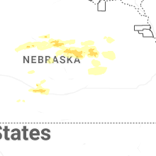
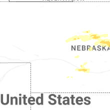
Nebraska
| Local Time | Report Details |
|---|---|
| 4:39 AM CDT | Quarter sized hail reported near Burwell, NE, 51.5 miles SSW of Oneill, NE, report from mping: quarter (1.00 in.). |
| 4:57 AM CDT | Baseball sized hail reported near Burwell, NE, 51.5 miles SW of Oneill, NE, report via social media. |
Connect with Interactive Hail Maps