

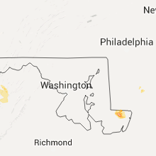
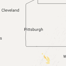
Hail Map for Friday, June 24, 2016

Number of Impacted Households on 6/24/2016
0
Impacted by 1" or Larger Hail
0
Impacted by 1.75" or Larger Hail
0
Impacted by 2.5" or Larger Hail
Square Miles of Populated Area Impacted on 6/24/2016
0
Impacted by 1" or Larger Hail
0
Impacted by 1.75" or Larger Hail
0
Impacted by 2.5" or Larger Hail


Cities Most Affected by Hail Storms of 6/24/2016
| Hail Size | Demographics of Zip Codes Affected | ||||||
|---|---|---|---|---|---|---|---|
| City | Count | Average | Largest | Pop Density | House Value | Income | Age |
| Pittsville, MD | 1 | 1.75 | 1.75 | 94 | $84k | $36.9k | 40.5 |
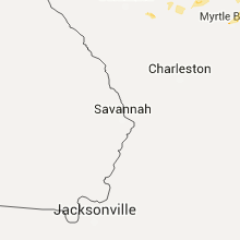
Hail and Wind Damage Spotted on 6/24/2016
Filter by Report Type:Hail ReportsWind Reports
States Impacted
Maryland, South Carolina, North Carolina, West Virginia, Virginia, Montana, Nebraska, Wyoming, Colorado, South Dakota, North DakotaMaryland
| Local Time | Report Details |
|---|---|
| 3:28 PM EDT | Golf Ball sized hail reported near Pittsville, MD, 18.1 miles WNW of Ocean City, MD, . |
South Carolina
| Local Time | Report Details |
|---|---|
| 4:08 PM EDT | Power lines down in lake vie in dillon county SC, 69.8 miles W of Wilmington, NC |
| 4:11 PM EDT | Trees down at crossing of old mullins hwy and sc9 in marion county SC, 68.9 miles W of Wilmington, NC |
| 4:13 PM EDT | Tree on old mullins hw in marion county SC, 70.6 miles W of Wilmington, NC |
| 4:24 PM EDT | Tree down on pocket r in florence county SC, 75.9 miles NNE of Charleston, SC |
| 4:34 PM EDT | Tree down on pocket r in florence county SC, 75.9 miles NNE of Charleston, SC |
| 5:07 PM EDT | Tree in roadway on hwy 40 in florence county SC, 54.3 miles N of Charleston, SC |
| 5:10 PM EDT | Quarter size hail in olanta in florence county SC, 51.5 miles N of Charleston, SC |
| 5:10 PM EDT | Quarter sized hail reported near Olanta, SC, 51.5 miles N of Charleston, SC, quarter size hail in olanta |
| 5:14 PM EDT | Schp reports trees down at kolb rd and starks ferry rd. time estimated based on rada in sumter county SC, 49.3 miles NNW of Charleston, SC |
| 5:27 PM EDT | Power lines on short cut r in florence county SC, 58.6 miles N of Charleston, SC |
| 5:27 PM EDT | Schp reports trees down on interstate 95 southbound near mile markers 137-13 in sumter county SC, 52 miles N of Charleston, SC |
| 5:29 PM EDT | Tree down on sc 1 in horry county SC, 61.7 miles WSW of Wilmington, NC |
| 5:30 PM EDT | Tree down at the intersection of mckenzie and scurry r in florence county SC, 49 miles N of Charleston, SC |
| 5:31 PM EDT | Tree on hwy 301 and iris r in florence county SC, 50.7 miles N of Charleston, SC |
| 5:37 PM EDT | Tree down on alford r in horry county SC, 69.3 miles WSW of Wilmington, NC |
| 5:37 PM EDT | Trees down at intersection of sc66 and holly hill rd in horry county SC, 55.4 miles WSW of Wilmington, NC |
| 5:39 PM EDT | Trees down at crossing of old mullins hwy and sc9 in marion county SC, 68.9 miles W of Wilmington, NC |
| 5:39 PM EDT | Tree on old mullins hw in marion county SC, 70.6 miles W of Wilmington, NC |
| 5:43 PM EDT | Tree uprooted on sc 90. relayed by medi in horry county SC, 63.8 miles WSW of Wilmington, NC |
| 5:49 PM EDT | Tree down on 62 ave in north myrtle beac in horry county SC, 61.3 miles WSW of Wilmington, NC |
| 5:56 PM EDT | Clarendon co 911 reports multiple trees down just outside summerton. in clarendon county SC, 34.5 miles NW of Charleston, SC |
| 6:15 PM EDT | Law enforcement and public reports of several trees down in the vicinity of george harvin rd... loss brook rd... and racoon r in clarendon county SC, 33.3 miles NNW of Charleston, SC |
| 6:37 PM EDT | Tree down on hwy 52 in williamsburg county SC, 37.3 miles NNE of Charleston, SC |
North Carolina
| Local Time | Report Details |
|---|---|
| 4:30 PM EDT | Trees down in fair bluff on hwy 904. vehicle in ditc in columbus county NC, 61.7 miles W of Wilmington, NC |
| 6:10 PM EDT | Tree down on a mobile home; 200 block of misty drive. time estimated by rada in randolph county NC, 58.3 miles NE of Charlotte, NC |
| 12:03 AM UTC | Rockingham county 911 center reported that one tree was down in the 8200 block of brann road blocking the road. the tree was also down on a power lin in rockingham county NC, 61.6 miles WNW of Raleigh, NC |
| 8:44 PM EDT | A tree down... taking power lines down with i in guilford county NC, 61.6 miles WNW of Raleigh, NC |
| 1:43 AM UTC | Rockingham county 911 center reported that one tree was down on north carolina highway 770 in stonevill in rockingham county NC, 55.3 miles S of Roanoke, VA |
| 1:43 AM UTC | Tree down in the 800 block of lawsonville avenue on the east side of reidsvill in rockingham county NC, 64.9 miles SSE of Roanoke, VA |
West Virginia
| Local Time | Report Details |
|---|---|
| 4:35 PM EDT | 3 inch diameter tree branches blocked road to house set on fire by lightning in grant county WV, 38.5 miles ENE of Elkins, WV |
| 4:45 PM EDT | 3 inch diameter tree branches blocked road to house set on fire by lightning in grant county WV, 33.4 miles ENE of Elkins, WV |
| 4:49 PM EDT | Very large tree branches blocking s fork road in hardy county WV, 48.5 miles ENE of Elkins, WV |
| 4:57 PM EDT | Tree down on lunice creek hwy north of petersburg in grant county WV, 39 miles E of Elkins, WV |
| 5:01 PM EDT | Tree down on car on south grove st in grant county WV, 39.3 miles E of Elkins, WV |
| 5:01 PM EDT | Half Dollar sized hail reported near Petersburg, WV, 39.3 miles E of Elkins, WV, tree down on car on south grove st |
| 5:01 PM EDT | Quarter sized hail reported near Petersburg, WV, 38.8 miles E of Elkins, WV |
| 5:05 PM EDT | Tree down on route 220 2 in grant county WV, 36.6 miles E of Elkins, WV |
| 5:06 PM EDT | Trees down on knob rd and durgon rd. both near south mill creek rd in grant county WV, 39.2 miles E of Elkins, WV |
| 5:18 PM EDT | Quarter sized hail reported near Mathias, WV, 50.4 miles E of Elkins, WV |
| 5:36 PM EDT | Several trees down along howards lick rd in hardy county WV, 52.6 miles E of Elkins, WV |
| 5:36 PM EDT | Several trees down along crab run road in hardy county WV, 52.2 miles E of Elkins, WV |
Virginia
| Local Time | Report Details |
|---|---|
| 6:09 PM EDT | Trees across road at hopkins gap rd and genoa rd intersection in rockingham county VA, 53.7 miles ESE of Elkins, WV |
| 9:57 PM EDT | Danville city 911 center reports that a tree was down on water street at the railroad track in city of danville county VA, 56.6 miles SE of Roanoke, VA |
Montana
| Local Time | Report Details |
|---|---|
| 4:10 PM MDT | Storm damage reported in fergus county MT, 75.8 miles NNW of Billings, MT |
| 4:33 PM MDT | Quarter sized hail reported near Roundup, MT, 72.4 miles N of Billings, MT |
| 4:40 PM MDT | Half Dollar sized hail reported near Winnett, MT, 74.2 miles N of Billings, MT, hail covered the ground |
| 5:10 PM MDT | Lufborough hill dot in garfield county MT, 88.5 miles SSW of Glasgow, MT |
| 5:45 PM MDT | Quarter sized hail reported near Jordan, MT, 78.5 miles NW of Miles City, MT |
| 6:05 PM MDT | Quarter sized hail reported near Jordan, MT, 71.9 miles NW of Miles City, MT |
| 6:05 PM MDT | Branches broken off trees in garfield county MT, 71.9 miles NW of Miles City, MT |
| 6:07 PM MDT | King coulee raws in valley county MT, 32.6 miles SSW of Glasgow, MT |
| 6:10 PM MDT | Quarter sized hail reported near Cohagen, MT, 62.2 miles NW of Miles City, MT |
| 6:11 PM MDT | Storm damage reported in garfield county MT, 61.8 miles SSW of Glasgow, MT |
| 6:15 PM MDT | Storm damage reported in garfield county MT, 57.6 miles NW of Miles City, MT |
| 6:15 PM MDT | Quarter sized hail reported near Cohagen, MT, 57.6 miles NW of Miles City, MT |
| 6:36 PM MDT | Storm damage reported in mccone county MT, 16.8 miles SE of Glasgow, MT |
| 6:44 PM MDT | Reported by off duty nws employee in valley county MT, 15.4 miles SE of Glasgow, MT |
| 7:00 PM MDT | Storm damage reported in dawson county MT, 59.2 miles NNE of Miles City, MT |
| 7:09 PM MDT | Storm damage reported in prairie county MT, 42.5 miles NNE of Miles City, MT |
| 7:24 PM MDT | Storm damage reported in mccone county MT, 71 miles N of Miles City, MT |
| 7:32 PM MDT | Storm damage reported in roosevelt county MT, 46.7 miles E of Glasgow, MT |
| 7:54 PM MDT | Storm damage reported in dawson county MT, 79.7 miles WSW of Williston, ND |
| 7:55 PM MDT | Trees ripped up on property... windows broken... and doors knocked out of jam in roosevelt county MT, 66.7 miles E of Glasgow, MT |
| 7:59 PM MDT | Storm damage reported in richland county MT, 62.6 miles WSW of Williston, ND |
| 8:15 PM MDT | Highway 13 closed by mile marker 17 for approximately 20 power poles broken in mccone county MT, 60.7 miles SE of Glasgow, MT |
| 8:18 PM MDT | Storm damage reported in roosevelt county MT, 65.8 miles W of Williston, ND |
| 8:20 PM MDT | Storm damage reported in richland county MT, 40.9 miles WSW of Williston, ND |
| 8:20 PM MDT | Numerous trees uprooted and roofs blown off in roosevelt county MT, 66.7 miles E of Glasgow, MT |
| 8:46 PM MDT | Storm damage reported in roosevelt county MT, 42.2 miles WNW of Williston, ND |
| 9:10 PM MDT | Storm damage reported in richland county MT, 36.4 miles WSW of Williston, ND |
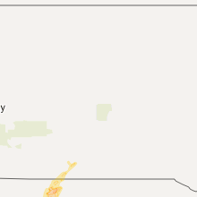
Nebraska
| Local Time | Report Details |
|---|---|
| 4:18 PM MDT | Sustained 39 mp in dawes county NE, 75 miles NNE of Scottsbluff, NE |
| 4:18 PM MDT | Sustained 39 mp in dawes county NE, 75 miles NNE of Scottsbluff, NE |
Wyoming
| Local Time | Report Details |
|---|---|
| 4:36 PM MDT | Sustained wind 30 mp in albany county WY, 0.5 miles E of Laramie, WY |
| 4:55 PM MDT | Storm damage reported in crook county WY, 52.7 miles ENE of Gillette, WY |
| 5:30 PM MDT | Storm damage reported in laramie county WY, 22.4 miles ENE of Laramie, WY |
Colorado
| Local Time | Report Details |
|---|---|
| 7:16 PM MDT | Ping Pong Ball sized hail reported near Snyder, CO, 50 miles WNW of Yuma, CO, tree damage was also experienced. |
South Dakota
| Local Time | Report Details |
|---|---|
| 7:18 PM MDT | Quarter sized hail reported near Tuthill, SD, 36.2 miles WNW of Valentine, NE |
North Dakota
| Local Time | Report Details |
|---|---|
| 10:05 PM CDT | Some branches were broken and torrential rain reported in williams county ND, 0.4 miles WNW of Williston, ND |
| 10:13 PM CDT | Storm damage reported in williams county ND, 32.7 miles N of Williston, ND |
| 10:20 PM CDT | Storm damage reported in mckenzie county ND, 28 miles SE of Williston, ND |
| 10:20 PM CDT | Quarter sized hail reported near Williston, ND, 21.4 miles NNW of Williston, ND |
| 10:20 PM CDT | High winds have continued through the time of the call 105 in williams county ND, 21.4 miles NNW of Williston, ND |
| 10:49 PM CDT | Watford city raws statio in mckenzie county ND, 35 miles SSE of Williston, ND |
| 4:00 AM UTC | Winds stayed high for some time in mountrail county ND, 53.7 miles ESE of Williston, ND |
| 11:05 PM CDT | Storm damage reported in mountrail county ND, 51.1 miles W of Minot, ND |
| 4:39 AM UTC | Storm damage reported in mountrail county ND, 34.9 miles W of Minot, ND |
| 4:57 AM UTC | Mesonet station lostwood /lwdn8 in burke county ND, 57.6 miles WNW of Minot, ND |
Connect with Interactive Hail Maps