

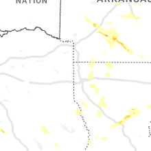
Hail Map for Wednesday, October 12, 2022

Number of Impacted Households on 10/12/2022
0
Impacted by 1" or Larger Hail
0
Impacted by 1.75" or Larger Hail
0
Impacted by 2.5" or Larger Hail
Square Miles of Populated Area Impacted on 10/12/2022
0
Impacted by 1" or Larger Hail
0
Impacted by 1.75" or Larger Hail
0
Impacted by 2.5" or Larger Hail


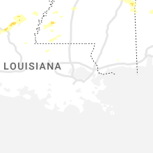


Cities Most Affected by Hail Storms of 10/12/2022
| Hail Size | Demographics of Zip Codes Affected | ||||||
|---|---|---|---|---|---|---|---|
| City | Count | Average | Largest | Pop Density | House Value | Income | Age |
| Shelby, MS | 2 | 1.88 | 2.00 | 7 | $41k | $16.6k | 31.3 |
| Gallion, AL | 1 | 2.00 | 2.00 | 22 | $65k | $31.5k | 42.3 |
| Pineville, LA | 1 | 2.00 | 2.00 | 181 | $80k | $32.7k | 36.4 |
| Tupelo, MS | 1 | 1.75 | 1.75 | 391 | $91k | $38.3k | 35.1 |
| New Albany, MS | 1 | 1.75 | 1.75 | 107 | $70k | $32.4k | 37.4 |
| Hickory, MS | 1 | 1.75 | 1.75 | 22 | $55k | $27.3k | 37.2 |
| Saltillo, MS | 1 | 1.75 | 1.75 | 151 | $88k | $38.4k | 36.6 |
| Guin, AL | 1 | 1.75 | 1.75 | 36 | $61k | $29.0k | 44.2 |
Hail and Wind Damage Spotted on 10/12/2022
Filter by Report Type:Hail ReportsWind Reports
States Impacted
Michigan, Alabama, Missouri, Arkansas, Wisconsin, Illinois, Kentucky, Tennessee, Mississippi, Ohio, LouisianaMichigan
| Local Time | Report Details |
|---|---|
| 8:15 AM EDT | Buoy station 45023 3 w portage cana in lsz243 county MI, 75.6 miles NW of Marquette, MI |
| 10:30 AM EDT | Ship measured 65 to 70 mph winds at 100ft agl in the vicinity of thunderstorm outflow. winds were sustained at around 40 mph after strong gusts passed. location estimat in lsz266 county MI, 61.8 miles N of Marquette, MI |
Alabama
| Local Time | Report Details |
|---|---|
| 7:22 AM CDT | Quarter sized hail reported near Demopolis, AL, 45.8 miles NW of Camden, AL, social media pictures and videos of hail at least quarter size falling in demopolis. |
| 7:30 AM CDT | Hen Egg sized hail reported near Gallion, AL, 43.6 miles NW of Camden, AL, social media photos of large hail near gallion. |
| 2:04 PM CDT | Trees and power lines down near burkvill in lowndes county AL, 49.7 miles ENE of Camden, AL |
| 2:23 PM CDT | Trees down along us-31 at the sandy ridge communit in lowndes county AL, 49.4 miles E of Camden, AL |
| 2:28 PM CDT | Trees down blocking us-31 at pintlal in montgomery county AL, 55.5 miles ENE of Camden, AL |
| 2:42 PM CDT | Trees down blocking highway 94 on the east and west sides of rame in montgomery county AL, 57.8 miles SW of Auburn, AL |
| 3:08 PM CDT | Several trees down in the area including hwy 110 and hwy 22 in bullock county AL, 35.1 miles SSW of Auburn, AL |
| 7:15 PM CDT | Ping Pong Ball sized hail reported near Hamilton, AL, 51.3 miles SSW of Florence, AL, ping pong ball sized hail reported near i-22 and hwy 17 in hamilton. time estimated by radar. |
| 7:30 PM CDT | Golf Ball sized hail reported near Guin, AL, 53.1 miles SSW of Florence, AL, golf ball sized hail reported along i-22 at hwy 43 south of hamilton. time estimated by radar. |
Missouri
| Local Time | Report Details |
|---|---|
| 7:52 AM CDT | Quarter sized hail reported near Nixa, MO, 11.8 miles SSW of Springfield, MO, quarter or larger hail between nixa and clever. time and exact location estimated from radar. |
| 8:05 AM CDT | Quarter sized hail reported near Ozark, MO, 13.8 miles SSE of Springfield, MO, photo sent via social media. |
| 8:15 AM CDT | Quarter sized hail reported near Ozark, MO, 13.8 miles SSE of Springfield, MO, quarter size hail reported in ozark. |
Arkansas
| Local Time | Report Details |
|---|---|
| 8:05 AM CDT | Quarter sized hail reported near Decatur, AR, 65.9 miles N of Fort Smith, AR, spotter reported 1 inch hail just west of decatur. |
| 9:25 AM CDT | Quarter sized hail reported near Fayetteville, AR, 49 miles NNE of Fort Smith, AR, social media report with video of nickel to quarter size hail falling in fayetteville. |
| 10:10 AM CDT | Quarter sized hail reported near Paris, AR, 35.6 miles E of Fort Smith, AR |
| 11:30 AM CDT | Quarter sized hail reported near Saffell, AR, 87.4 miles NW of Memphis, TN |
| 11:38 AM CDT | Quarter sized hail reported near Walnut Ridge, AR, 81.6 miles NW of Memphis, TN, nickel and quarter size hail on the west side of hoxie... ar in lawrence county. |
| 6:35 PM CDT | Quarter sized hail reported near Cabot, AR, 21 miles NE of Little Rock, AR, several reports of nickel to quarter size hail across the city of cabot. |
| 6:44 PM CDT | Quarter sized hail reported near Cabot, AR, 22.2 miles NE of Little Rock, AR, social media picture of hail from cabot. |
| 8:21 PM CDT | Tree down across highway 7 near new st. marys churc in ouachita county AR, 61.9 miles ESE of Nashville, AR |
| 10:18 PM CDT | Asos station keld el dorado goodwin field airpor in union county AR, 60.7 miles WNW of Bastrop, LA |
Wisconsin
| Local Time | Report Details |
|---|---|
| 9:41 AM CDT | Large branches down. patio table and chairs blown over. time estimated from rada in marquette county WI, 49.6 miles N of Madison, WI |
| 11:36 AM CDT | Several trees and powerlines down in the the city of whitewate in walworth county WI, 36.5 miles ESE of Madison, WI |
| 11:39 AM CDT | Mping reports from lac la belle... oconomowoc and hartland of trees uprooted or snapped. time estimated from rada in waukesha county WI, 45.4 miles E of Madison, WI |
| 11:43 AM CDT | Reports of multiple trees down and a few powerlines down. time estimated from rada in waukesha county WI, 48 miles E of Madison, WI |
| 11:45 AM CDT | Relayed via social medi in washington county WI, 53.4 miles ENE of Madison, WI |
| 11:53 AM CDT | Tree snapped and large limbs down. time estimated from rada in waukesha county WI, 54.7 miles E of Madison, WI |
| 11:55 AM CDT | Straight line wind damage report of an uprooted tree on a house and a pier ripped up on turtle lake. relayed via delavan fire chie in walworth county WI, 43 miles ESE of Madison, WI |
| 12:10 PM CDT | Large tree down. time estimated from rada in waukesha county WI, 64.1 miles E of Madison, WI |
| 12:19 PM CDT | Limb down. 1.5 foot diamete in waukesha county WI, 56.7 miles E of Madison, WI |
| 12:24 PM CDT | Large trees down. roof damage on a nearby barn. time estimated from rada in racine county WI, 62.2 miles NNW of Chicago, IL |
| 12:24 PM CDT | Large trees down on hayes avenue between 72nd and 74th streets. power lines down on 72nd street between hayes avenue and beloit road. time estimated from rada in milwaukee county WI, 70.4 miles E of Madison, WI |
| 12:26 PM CDT | Report from mping: 3-inch tree limbs broken; power poles broken. estimated 50-60 mp in milwaukee county WI, 68.2 miles E of Madison, WI |
| 12:29 PM CDT | Numerous trees and branches dow in milwaukee county WI, 74.4 miles N of Chicago, IL |
| 12:30 PM CDT | 3 inch diameter tree limbs snapped at 2nd street and plainfield avenue. time estimated from rada in milwaukee county WI, 75.1 miles E of Madison, WI |
| 12:30 PM CDT | Large tree limbs down. time estimated from rada in milwaukee county WI, 76 miles N of Chicago, IL |
| 12:34 PM CDT | Peak gust at mitchell internationa in milwaukee county WI, 74.8 miles N of Chicago, IL |
| 12:38 PM CDT | Report from mping: 3-inch tree limbs broken; power poles broke in walworth county WI, 48.7 miles SE of Madison, WI |
| 12:40 PM CDT | Tree branches down along e bolivar ave along with some yard decorations damage in milwaukee county WI, 75.6 miles E of Madison, WI |
| 12:46 PM CDT | Trees downed 68th & harrison and 65th & cleveland ave milwaukee/west allis borde in milwaukee county WI, 68.8 miles E of Madison, WI |
| 12:47 PM CDT | Trees and large branches down. time estimated from rada in racine county WI, 60.6 miles N of Chicago, IL |
| 12:47 PM CDT | Large tree limb down. time estimated from rada in kenosha county WI, 50.8 miles NNW of Chicago, IL |
| 12:52 PM CDT | Report from mping: 1-inch tree limbs broken; shingles blown of in milwaukee county WI, 74.8 miles E of Madison, WI |
| 1:00 PM CDT | Large limbs down. time estimated from rada in milwaukee county WI, 73.6 miles E of Madison, WI |
Illinois
| Local Time | Report Details |
|---|---|
| 12:20 PM CDT | County dispatch relayed a report of a power pole downed from the line of showers. time estimated by rada in mchenry county IL, 57.5 miles NW of Chicago, IL |
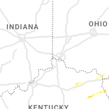
Kentucky
| Local Time | Report Details |
|---|---|
| 3:27 PM EDT | Trees down on us route 62 just west of sardis. damage to a barn roo in robertson county KY, 49.1 miles SE of Cincinnati, OH |
| 6:05 PM EDT | Corrects previous tstm wnd dmg report from 1 ne flat creek. tree down along flat creek road. time estimated from rada in bath county KY, 31.7 miles NNE of Irvine, KY |
| 5:08 PM CDT | Trees reported down near the intersection of knob lick road and sulphur well knob lick roa in metcalfe county KY, 62.6 miles S of Louisville, KY |
| 6:13 PM EDT | Corrects previous tstm wnd dmg report from reynoldsville. thunderstorm wind gusts caused significant damage to a barn and an out building in the reynoldsville area. at in bath county KY, 34.8 miles NNE of Irvine, KY |
| 6:18 PM EDT | Corrects previous tstm wnd dmg report from odessa. trees down along white oak road off of highway 36. time estimated from rada in bath county KY, 37.9 miles NNE of Irvine, KY |
| 6:21 PM EDT | Corrects previous tstm wnd dmg report from 2 nw odessa. trees down along east fork road. time estimated from rada in bath county KY, 38.6 miles NNE of Irvine, KY |
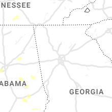
Tennessee
| Local Time | Report Details |
|---|---|
| 3:05 PM CDT | Trees and powerlines down across saltillo... pickwick... big ivy... and gillis mills area in hardin county TN, 50.1 miles NW of Florence, AL |
| 3:33 PM CDT | Large tree branch down causing some roof damage to a house and also to a ca in henderson county TN, 34.1 miles SSE of Mc Kenzie, TN |
| 3:57 PM CDT | Gas station awning destroyed by winds near walmart in fairview. tspotter repor in williamson county TN, 24.8 miles SW of Nashville, TN |
| 4:00 PM CDT | Large tree limbs down at the intersection of hwy 100 and westview blv in williamson county TN, 25.7 miles SW of Nashville, TN |
| 4:03 PM CDT | Large trees down and blocking road on cumberland drive and sugar maple driv in williamson county TN, 23.4 miles SW of Nashville, TN |
| 4:25 PM CDT | Twitter tspotter photo showed a tree snapped near crockett par in williamson county TN, 13 miles S of Nashville, TN |
| 4:32 PM CDT | Tree fell on a house in east nashville near mas tacos with siding damage on the hous in davidson county TN, 2.2 miles NE of Nashville, TN |
| 4:32 PM CDT | Tree down on fenc in williamson county TN, 17.3 miles SSE of Nashville, TN |
| 4:43 PM CDT | Two lanes blocked by fallen tree at the intersection of gallatin road and big station camp blvd. tspotter repor in sumner county TN, 18.7 miles NE of Nashville, TN |
| 4:57 PM CDT | 24 inch diameter maple tree down on garage in dunn... south of lawrencebur in lawrence county TN, 32.9 miles NE of Florence, AL |
| 6:12 PM CDT | Trees fell on power lines on college street at the intersection of hwy 41 and hwy 5 in coffee county TN, 52.8 miles NW of Chattanooga, TN |
| 6:15 PM CDT | Significant wind damage occurred across manchester. two gas stations at interstate dr and hwy 55 suffered awning and roof damage... a nearby building lost much of its r in coffee county TN, 52.4 miles NW of Chattanooga, TN |
| 6:35 PM CDT | Awos station krnc mcminnville airpor in warren county TN, 54.1 miles NNW of Chattanooga, TN |
Mississippi
| Local Time | Report Details |
|---|---|
| 4:00 PM CDT | Golf Ball sized hail reported near Shelby, MS, 91.7 miles SSW of Memphis, TN, golf ball size hail reported in shelby ms. |
| 4:07 PM CDT | Hen Egg sized hail reported near Shelby, MS, 91.7 miles SSW of Memphis, TN, hail estimated to be 2-2.25 inches in diameter was reported around shelby. a video showed a hail shower with varying sizes of large hail. reported via social media. |
| 4:26 PM CDT | Quarter sized hail reported near Drew, MS, 90.6 miles SSW of Memphis, TN |
| 4:30 PM CDT | Half Dollar sized hail reported near Parchman, MS, 88.6 miles SSW of Memphis, TN, half dollar sized hail reported near parchman. reported via social media. |
| 5:01 PM CDT | Golf Ball sized hail reported near New Albany, MS, 71.6 miles N of Starkville, MS, corrects previous hail report from new albany. nickle sized hail in ingomar. |
| 5:06 PM CDT | Quarter sized hail reported near Walnut Grove, MS, 54.2 miles ENE of Jackson, MS |
| 5:10 PM CDT | Quarter sized hail reported near Forest, MS, 41.9 miles E of Jackson, MS |
| 5:40 PM CDT | Golf Ball sized hail reported near Saltillo, MS, 63.4 miles N of Starkville, MS, corrects previous hail report from saltillo. half dollar sized hail reported in saltillo... ms. |
| 5:50 PM CDT | Quarter sized hail reported near Tupelo, MS, 59.2 miles N of Starkville, MS, quarter size hail fell just north of barnes crossing road. |
| 6:08 PM CDT | Golf Ball sized hail reported near Tupelo, MS, 54.9 miles N of Starkville, MS, corrects previous hail report from tupelo. golf ball size hail reportd on twitter. |
| 6:13 PM CDT | Half Dollar sized hail reported near Mooreville, MS, 57 miles NNE of Starkville, MS, half dollar size hail fell in mooreville. |
| 6:14 PM CDT | Quarter sized hail reported near Tupelo, MS, 54.9 miles N of Starkville, MS, quarter sized hail report sent on twitter. |
| 6:29 PM CDT | Quarter sized hail reported near Fulton, MS, 55.7 miles SW of Florence, AL, corrects previous hail report from fulton. quarter sized hail. |
| 6:30 PM CDT | Report from mping: 1-inch tree limbs broken; shingles blown of in lauderdale county MS, 80.8 miles S of Starkville, MS |
| 6:30 PM CDT | Golf Ball sized hail reported near Hickory, MS, 67.3 miles E of Jackson, MS, ping pong to golf ball sized hail reported south of hickory. reported via social media. |
| 6:31 PM CDT | Quarter sized hail reported near Meridian, MS, 80.8 miles S of Starkville, MS, report from mping: quarter (1.00 in.). |
| 6:40 PM CDT | Ping Pong Ball sized hail reported near Fulton, MS, 56 miles NNE of Starkville, MS, ping pong size hail in tilden. |
| 6:51 PM CDT | Quarter sized hail reported near Roxie, MS, 72 miles SW of Jackson, MS |
| 7:14 PM CDT | Quarter sized hail reported near Sarah, MS, 39.5 miles SSW of Memphis, TN |
| 8:39 PM CDT | Quarter sized hail reported near Olive Branch, MS, 18.5 miles SE of Memphis, TN, corrects previous hail report from olive branch. spotter called in to report quarter size hail. |
| 11:35 PM CDT | Powerlines dow in monroe county MS, 24.9 miles NNE of Starkville, MS |
| 12:14 AM CDT | Large tree down across 8th stree in lowndes county MS, 22.8 miles E of Starkville, MS |
| 12:18 AM CDT | Two trees blown down across blackjack roa in oktibbeha county MS, 1.7 miles SE of Starkville, MS |
Ohio
| Local Time | Report Details |
|---|---|
| 5:20 PM EDT | Quarter sized hail reported near Ironton, OH, 52.4 miles WNW of Charleston, WV, quarter sized hail observed. |
Louisiana
| Local Time | Report Details |
|---|---|
| 5:26 PM CDT | Quarter sized hail reported near Dry Prong, LA, 87.8 miles NNW of Lafayette, LA, public reports quarter size hail in the creola community in grant parish. |
| 5:26 PM CDT | Half Dollar sized hail reported near Dry Prong, LA, 87.8 miles NNW of Lafayette, LA, corrects previous hail report from 8 ssw pollock. reports of quarter to half dollar size hail in the creola community in grant parish. |
| 5:33 PM CDT | Hen Egg sized hail reported near Pineville, LA, 88.2 miles NNW of Lafayette, LA, photos of hail near the creola community via kalb social media page. |
| 5:40 PM CDT | Quarter sized hail reported near Pollock, LA, 91.4 miles SSW of Bastrop, LA, social media photos of quarter size hail in the pollock area. |
| 5:50 PM CDT | Ping Pong Ball sized hail reported near Pollock, LA, 90.5 miles SSW of Bastrop, LA, reported off highway 8 between pollock and lasalle parish border via social media photo. |
| 5:55 PM CDT | Half Dollar sized hail reported near Pollock, LA, 85.9 miles SSW of Bastrop, LA, public report of hail on bodies landing road near the little river at the grant and lasalle parish border. |
| 6:30 PM CDT | Quarter sized hail reported near Jena, LA, 77.6 miles S of Bastrop, LA, photos and videos of hail off highway 84 southeast of jena. |
Connect with Interactive Hail Maps