

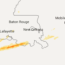
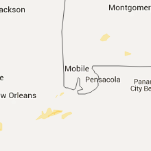
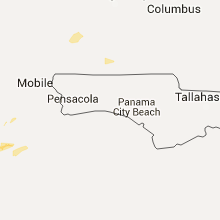
Hail Map for Friday, April 1, 2016

Number of Impacted Households on 4/1/2016
0
Impacted by 1" or Larger Hail
0
Impacted by 1.75" or Larger Hail
0
Impacted by 2.5" or Larger Hail
Square Miles of Populated Area Impacted on 4/1/2016
0
Impacted by 1" or Larger Hail
0
Impacted by 1.75" or Larger Hail
0
Impacted by 2.5" or Larger Hail


Cities Most Affected by Hail Storms of 4/1/2016
| Hail Size | Demographics of Zip Codes Affected | ||||||
|---|---|---|---|---|---|---|---|
| City | Count | Average | Largest | Pop Density | House Value | Income | Age |
Hail and Wind Damage Spotted on 4/1/2016
Filter by Report Type:Hail ReportsWind Reports
States Impacted
Mississippi, Michigan, Texas, Alabama, Georgia, South Carolina, Virginia, Maine, New JerseyMississippi
| Local Time | Report Details |
|---|---|
| 7:57 AM CDT | Emergency manager reports damage to power poles near the junction of interstates 10 and 110. tree and power line damage also reported directly across county line on big in harrison county MS, 54.5 miles WSW of Mobile, AL |
| 1:54 PM CDT | Quarter sized hail reported near Woodville, MS, 74.1 miles NE of Lafayette, LA, public report of quarter sized hail relayed by nws employee. time estimated from radar. |
Michigan
| Local Time | Report Details |
|---|---|
| 8:59 AM EDT | Tree down across road near north elm street between 6 and 7 pm 3/31/16. dead pine 70ft tall approx.12.5 inch diameter. car hit tree - no injuries. road temporarily clos in lapeer county MI, 18.7 miles E of Flint, MI |
Texas
| Local Time | Report Details |
|---|---|
| 8:32 AM CDT | Quarter sized hail reported near Canyon Lake, TX, 33.7 miles NNE of San Antonio, TX, nickel sized hail starting to cover the ground with a few quarter sized hailstones |
Alabama
| Local Time | Report Details |
|---|---|
| 10:55 AM CDT | Tree down near browns crossroads in dale county AL, 81.9 miles S of Auburn, AL |
| 11:16 AM CDT | Large trees down at goodwyn middle school. estimated 40 to 50 mile per hour winds due to saturated ground. time estimated by rada in montgomery county AL, 47.5 miles WSW of Auburn, AL |
Georgia
| Local Time | Report Details |
|---|---|
| 3:54 PM EDT | Trees and powerlines reported down in the vicinity of andrews chapel rd and ginhouse rd. time estimated based on rada in screven county GA, 45.2 miles SE of Augusta, GA |
| 4:15 PM EDT | Tree down in thomas county GA, 33.9 miles NE of Tallahassee, FL |
| 4:15 PM EDT | Tree down in thomas county GA, 43.7 miles NE of Tallahassee, FL |
| 4:15 PM EDT | Dogwood tree blown down in pavo in brooks county GA, 48.2 miles NE of Tallahassee, FL |
| 4:40 PM EDT | Tree fell on powerlines in brooks county GA, 55.1 miles SW of Douglas, GA |
| 4:47 PM EDT | Tree down with power lines down on stanfill street in hahira in lowndes county GA, 47 miles SW of Douglas, GA |
| 4:57 PM EDT | Traffic light blown down at country club dr and north valdosta road in lowndes county GA, 51 miles SSW of Douglas, GA |
| 4:57 PM EDT | Tree down and power line down in berrien county GA, 26.8 miles SW of Douglas, GA |
| 5:00 PM EDT | Power line down in berrien county GA, 36.5 miles SW of Douglas, GA |
| 5:00 PM EDT | Power lines down along north perimeter road in lowndes county GA, 50.1 miles SSW of Douglas, GA |
| 5:00 PM EDT | Tree down on a house on worth ave in lowndes county GA, 50.4 miles SSW of Douglas, GA |
| 5:00 PM EDT | 911 call center reports a tree down near the intersection of caney bay rd and britt still r in brantley county GA, 53.5 miles ESE of Douglas, GA |
| 5:03 PM EDT | Tree down on i-75 near mile post 13 blocking two right lanes in lowndes county GA, 56.7 miles SSW of Douglas, GA |
| 5:03 PM EDT | Trees down along browning road in lanier county GA, 29.5 miles SSW of Douglas, GA |
| 5:07 PM EDT | Trees down along royals road in lanier county GA, 33.4 miles SSW of Douglas, GA |
| 5:12 PM EDT | 911 call center reports a tree fell on a powerline at the intersection of albert gibson rd and browntown r in pierce county GA, 50.3 miles ESE of Douglas, GA |
| 5:15 PM EDT | Tree down on i-75 near mm6 in lowndes county GA, 59.7 miles SSW of Douglas, GA |
| 5:15 PM EDT | Tree down on river road in lanier county GA, 45.6 miles SSW of Douglas, GA |
| 5:17 PM EDT | Emergency manager reports numerous trees and powerlines down off of hwy 441 near guest millpond. time estimated from rada in clinch county GA, 22.4 miles S of Douglas, GA |
| 5:20 PM EDT | Emergency manager reports numerous trees and powerlines down near the intersection of mexico road and cogdell roa in atkinson county GA, 21.5 miles S of Douglas, GA |
| 5:20 PM EDT | Clinch county emergency management relayed several photograhs depicting uprooted large trees...snapped trees...and significant structural damage to a home in the guest in clinch county GA, 22.4 miles S of Douglas, GA |
| 5:20 PM EDT | Clinch county emergency management relayed several photograhs depicting uprooted large trees...snapped trees...and significant structural damage to a home in the guest in clinch county GA, 22.4 miles S of Douglas, GA |
| 5:24 PM EDT | 911 call center reports a tree fell on a powerline at the intersection of albert gibson rd and browntown r in brantley county GA, 65.1 miles ESE of Douglas, GA |
| 5:24 PM EDT | Emergency manager reports minor structure damage to a few mobile homes and barns in the 2200 block of fiddler green roa in atkinson county GA, 17.7 miles SSE of Douglas, GA |
| 5:35 PM EDT | Wjax-tv relayed photos from the public of a tin roof blown off a residence.time of damage based on radar dat in ware county GA, 25.7 miles ESE of Douglas, GA |
| 6:00 PM EDT | Emergency manager reports a powerline down in the southeast part of bacon county. time and location approximat in bacon county GA, 28.4 miles E of Douglas, GA |
| 6:06 PM EDT | 911 call center reports 1 large tree down on radio station rd. time based on rada in pierce county GA, 30.6 miles ESE of Douglas, GA |
| 6:06 PM EDT | Dispatch reports several trees and powerlines down around waycros in ware county GA, 35.4 miles SE of Douglas, GA |
| 6:36 PM EDT | 911 dispatch reports a tree down on north brunswick street and another tree down on old screven rd. time estimated from rada in wayne county GA, 56.5 miles E of Douglas, GA |
| 11:07 PM EDT | Wjax-tv relayed photos from the public of a tin roof blown off a residence.time of damage based on radar dat in ware county GA, 25.7 miles ESE of Douglas, GA |
South Carolina
| Local Time | Report Details |
|---|---|
| 4:04 PM EDT | Via web page lsr form. tree blown down during thunderstor in lexington county SC, 50.3 miles NE of Augusta, GA |
| 4:09 PM EDT | Tree down clarkson rd at bluff r in richland county SC, 65.3 miles NW of Charleston, SC |
| 4:14 PM EDT | Tree in roadway stump rd @ sc6 in lexington county SC, 52.5 miles NE of Augusta, GA |
| 4:34 PM EDT | Trees down greystone blvd and i126 in richland county SC, 63.2 miles NE of Augusta, GA |
| 5:13 PM EDT | Trees down fish and raccoon roads in sumter county SC, 62.9 miles NNW of Charleston, SC |
Virginia
| Local Time | Report Details |
|---|---|
| 4:18 PM EDT | Quarter sized hail reported near Covesville, VA, 63.3 miles WNW of Richmond, VA, covesville store |
Maine
| Local Time | Report Details |
|---|---|
| 4:22 PM EDT | Tree fell through roof of a house on middle jam road within gorham town line in cumberland county ME, 14.2 miles NW of Portland, ME |
| 4:25 PM EDT | Branch down at lee used cars in cumberland county ME, 14.9 miles NW of Portland, ME |
| 4:25 PM EDT | Flag pole cracked by winds at bucks naked barbeque in cumberland county ME, 11.9 miles NW of Portland, ME |
| 4:30 PM EDT | 18 inch diameter maple tree snapped in half on shaker roa in cumberland county ME, 17 miles NNW of Portland, ME |
| 4:30 PM EDT | Tree down on whites bridge road in cumberland county ME, 15.7 miles WNW of Portland, ME |
| 4:35 PM EDT | Shed moved from its foundation and well cover blown off. limbs dow in cumberland county ME, 12.9 miles NNW of Portland, ME |
New Jersey
| Local Time | Report Details |
|---|---|
| 6:08 PM EDT | Wires down in hunterdon county NJ, 53.7 miles WSW of Brooklyn, NY |
Connect with Interactive Hail Maps