

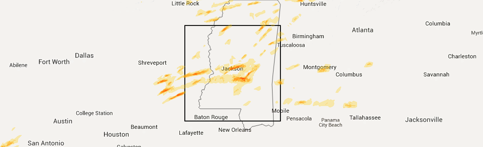
Hail Map for Thursday, March 31, 2016
Number of Impacted Households on 3/31/2016
0
Impacted by 1" or Larger Hail
0
Impacted by 1.75" or Larger Hail
0
Impacted by 2.5" or Larger Hail
Square Miles of Populated Area Impacted on 3/31/2016
0
Impacted by 1" or Larger Hail
0
Impacted by 1.75" or Larger Hail
0
Impacted by 2.5" or Larger Hail


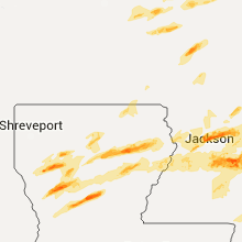


Cities Most Affected by Hail Storms of 3/31/2016
| Hail Size | Demographics of Zip Codes Affected | ||||||
|---|---|---|---|---|---|---|---|
| City | Count | Average | Largest | Pop Density | House Value | Income | Age |
| Pollock, LA | 2 | 1.88 | 2.00 | 28 | $66k | $32.5k | 35.0 |
| Union, MS | 2 | 1.75 | 1.75 | 43 | $53k | $27.7k | 39.1 |
| Delhi, LA | 1 | 2.00 | 2.00 | 22 | $52k | $23.0k | 38.4 |
| Mathiston, MS | 1 | 1.75 | 1.75 | 35 | $56k | $27.8k | 38.8 |
| Lake, MS | 1 | 1.75 | 1.75 | 26 | $50k | $25.1k | 36.8 |
| Columbia, TN | 1 | 1.75 | 1.75 | 185 | $97k | $41.0k | 38.6 |
| Baskin, LA | 1 | 1.75 | 1.75 | 18 | $47k | $26.8k | 39.5 |
| Provencal, LA | 1 | 1.75 | 1.75 | 2 | $67k | $31.3k | 38.8 |
| Coushatta, LA | 1 | 1.75 | 1.75 | 24 | $49k | $23.4k | 38.5 |
| Reagan, TN | 1 | 1.75 | 1.75 | 37 | $68k | $30.3k | 39.9 |
| Amory, MS | 1 | 1.75 | 1.75 | 89 | $69k | $31.7k | 40.9 |
| Bolton, MS | 1 | 1.75 | 1.75 | 23 | $58k | $30.0k | 42.9 |
| Brandon, MS | 1 | 1.75 | 1.75 | 154 | $110k | $47.9k | 37.7 |
| Philadelphia, MS | 1 | 1.75 | 1.75 | 63 | $56k | $28.4k | 34.2 |
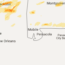
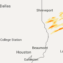
Hail and Wind Damage Spotted on 3/31/2016
Filter by Report Type:Hail ReportsWind Reports
States Impacted
Mississippi, Arkansas, Iowa, Alabama, Tennessee, Wisconsin, Kentucky, Louisiana, Indiana, Illinois, Ohio, Michigan, Georgia, TexasMississippi
| Local Time | Report Details |
|---|---|
| 7:54 AM CDT | Several trees down at the upper elementary school. possible tornad in lamar county MS, 86.4 miles WNW of Mobile, AL |
| 7:56 AM CDT | Trees and power lines down near aldon road and stonfield drive. possible tornad in lamar county MS, 84.8 miles WNW of Mobile, AL |
| 2:48 PM CDT | Tree down on hwy 184 blocking traffi in lawrence county MS, 51.6 miles S of Jackson, MS |
| 2:52 PM CDT | Tree down on hwy 2 in lawrence county MS, 45.5 miles S of Jackson, MS |
| 4:06 PM CDT | Quarter sized hail reported near Sallis, MS, 55 miles NNE of Jackson, MS |
| 4:08 PM CDT | Tree downed on utility equipment along ms hwy 14 in attala county MS, 54.1 miles NNE of Jackson, MS |
| 4:24 PM CDT | Golf Ball sized hail reported near Lake, MS, 44.6 miles E of Jackson, MS, hail ranging from pea to golf ball size on i-20 |
| 4:28 PM CDT | Golf Ball sized hail reported near Bolton, MS, 16.7 miles WNW of Jackson, MS |
| 4:42 PM CDT | Trees down on link r in yazoo county MS, 25.9 miles NNW of Jackson, MS |
| 4:44 PM CDT | Quarter sized hail reported near Sandersville, MS, 75.6 miles ESE of Jackson, MS |
| 4:45 PM CDT | Golf Ball sized hail reported near Union, MS, 58.6 miles ENE of Jackson, MS |
| 4:46 PM CDT | Several trees down in this are in yazoo county MS, 28 miles NNW of Jackson, MS |
| 4:50 PM CDT | Trees and limbs down on old hwy 49 and banks lan in yazoo county MS, 30.5 miles NNW of Jackson, MS |
| 4:50 PM CDT | Quarter sized hail reported near Union, MS, 64.3 miles SSW of Starkville, MS |
| 4:50 PM CDT | Wall of a barn and a fence blown dow in newton county MS, 64.3 miles SSW of Starkville, MS |
| 4:53 PM CDT | Golf Ball sized hail reported near Union, MS, 63.5 miles SSW of Starkville, MS, golf ball size hail reported on union madden rd. |
| 4:54 PM CDT | Quarter sized hail reported near Union, MS, 61.9 miles SSW of Starkville, MS, dime to quarter size hail reported near deemer rd and hwy 492. |
| 5:00 PM CDT | Trees down on myrleville roa in yazoo county MS, 34.7 miles NNW of Jackson, MS |
| 5:04 PM CDT | Tree down on a house near hwy 491 and cr 430 in neshoba county MS, 56.7 miles S of Starkville, MS |
| 5:05 PM CDT | Several trees and powerlines down near hwy 51 and yandell rd are in madison county MS, 15.7 miles NNE of Jackson, MS |
| 5:05 PM CDT | Large tree down across hwy 1 in neshoba county MS, 55.7 miles SSW of Starkville, MS |
| 5:05 PM CDT | Golf Ball sized hail reported near Philadelphia, MS, 54.7 miles S of Starkville, MS, golf ball size hail reported off of hwy 491 near house. |
| 5:05 PM CDT | Quarter sized hail reported near Madison, MS, 15.7 miles NNE of Jackson, MS, nickel to quarter size hail reported in hwy 51 and yandell rd area. |
| 5:07 PM CDT | Quarter sized hail reported near Madison, MS, 16.6 miles NNE of Jackson, MS, quarter size hail reported at the germantown high school. |
| 5:08 PM CDT | Several trees downed in the deerfield community in madison county MS, 17.6 miles NNE of Jackson, MS |
| 5:12 PM CDT | Tree downed at natchez trace parkway and ms hwy 43 in madison county MS, 20.1 miles NE of Jackson, MS |
| 5:21 PM CDT | Golf Ball sized hail reported near Mathiston, MS, 17.2 miles W of Starkville, MS, reported in the blythe creek area |
| 5:27 PM CDT | Ping Pong Ball sized hail reported near Maben, MS, 13.3 miles W of Starkville, MS, reported south of maben |
| 5:34 PM CDT | Quarter sized hail reported near Hernando, MS, 22.3 miles S of Memphis, TN, quarter sized hail. most of the hail was dime to nickel sized hail. |
| 5:34 PM CDT | Wind gust of 50-60 mph in hernando with penny to nickel size hai in desoto county MS, 22.3 miles S of Memphis, TN |
| 5:42 PM CDT | Quarter sized hail reported near Lena, MS, 39.9 miles ENE of Jackson, MS |
| 5:48 PM CDT | Ping Pong Ball sized hail reported near Cedarbluff, MS, 15.6 miles NNW of Starkville, MS, near montpelier |
| 5:58 PM CDT | Tree downed on a house along cayuga rd in hinds county MS, 29.6 miles WSW of Jackson, MS |
| 5:58 PM CDT | Several trees downed along ms hwy 2 in hinds county MS, 28.6 miles WSW of Jackson, MS |
| 6:01 PM CDT | Tree downed blocking ms hwy 27 at old port gibson rd in hinds county MS, 27.9 miles WSW of Jackson, MS |
| 6:11 PM CDT | Quarter sized hail reported near Columbus, MS, 24 miles E of Starkville, MS, dime to quarter size hail |
| 6:18 PM CDT | Trees downed in the city of clinton in hinds county MS, 9.2 miles WNW of Jackson, MS |
| 6:25 PM CDT | Half Dollar sized hail reported near Amory, MS, 40.9 miles NNE of Starkville, MS, half dollar sized hail. |
| 6:30 PM CDT | Golf Ball sized hail reported near Amory, MS, 40.9 miles NNE of Starkville, MS, golf ball sized hail and about 20 mph wind gust in amory |
| 6:40 PM CDT | Quarter sized hail reported near Tupelo, MS, 52.2 miles N of Starkville, MS |
| 6:41 PM CDT | Trees downed on us hwy 49 south of florence. report via social medi in rankin county MS, 13.4 miles SSE of Jackson, MS |
| 6:43 PM CDT | Trees down. shingles blown off of multiple home in newton county MS, 64.3 miles SSW of Starkville, MS |
| 6:53 PM CDT | Quarter sized hail reported near Rome, MS, 85.6 miles SSW of Memphis, TN |
| 6:55 PM CDT | Several trees and powerlines down across the southern third of the county. four trees down on home in rankin county MS, 19.3 miles SE of Jackson, MS |
| 6:57 PM CDT | Multiple trees and powerlines down in the are in simpson county MS, 22.8 miles SSE of Jackson, MS |
| 7:05 PM CDT | Quarter sized hail reported near Brandon, MS, 20.9 miles ESE of Jackson, MS, along ms hwy 18 south of brandon. relayed via social media |
| 7:07 PM CDT | Multiple trees down. multiple roads closed due to debris. some structure damage from tree in simpson county MS, 32.6 miles SE of Jackson, MS |
| 7:10 PM CDT | Some trees and power lines dow in simpson county MS, 29.6 miles SE of Jackson, MS |
| 7:10 PM CDT | Golf Ball sized hail reported near Brandon, MS, 26.2 miles ESE of Jackson, MS, dime to golf ball size hail reported |
| 7:18 PM CDT | Trees were blown down in smith county MS, 31.5 miles ESE of Jackson, MS |
| 7:19 PM CDT | Quarter sized hail reported near Shannon, MS, 45 miles N of Starkville, MS, quarter sized hail in the old union commmunity with cg lightning and very heavy rain. |
| 7:26 PM CDT | Numerous trees downed across the county... including along ms hwy 37 and ms hwy 35 n. the skirting was blown off a mobile home. small hail was also reporte in smith county MS, 42.9 miles ESE of Jackson, MS |
| 7:32 PM CDT | Several trees down around the shongelo communit in smith county MS, 40.8 miles ESE of Jackson, MS |
| 7:39 PM CDT | Trees down in smith county MS, 51 miles ESE of Jackson, MS |
| 1:38 AM CDT | Ping Pong Ball sized hail reported near Brandon, MS, 23.1 miles ESE of Jackson, MS, picture and report relayed via social media. |
Arkansas
| Local Time | Report Details |
|---|---|
| 8:42 AM CDT | Quarter sized hail reported near Perryville, AR, 34.9 miles WNW of Little Rock, AR, quarter size hail in perryville. |
| 9:38 AM CDT | Quarter sized hail reported near Searcy, AR, 45.8 miles NE of Little Rock, AR, penny to quarter size hail in searcy. |
| 10:32 AM CDT | Quarter sized hail reported near Jonesboro, AR, 58.7 miles NW of Memphis, TN, 1 inch hail in west jonesboro. |
| 10:40 AM CDT | High winds took large chunks of siding off a downtown jonesboro buildin in craighead county AR, 58.7 miles NW of Memphis, TN |
| 11:00 AM CDT | Quarter sized hail reported near Cabot, AR, 21 miles NE of Little Rock, AR, quarter size hail reported in cabot. |
| 11:00 AM CDT | Ping Pong Ball sized hail reported near Cabot, AR, 21 miles NE of Little Rock, AR, ping pong ball size hail reported through social media. |
| 12:00 PM CDT | Quarter sized hail reported near Lepanto, AR, 35.5 miles NNW of Memphis, TN, 1 inch hail in lepanto. |
| 12:00 PM CDT | Semi-truck blown over on i-55 south of burdett in mississippi county AR, 43.1 miles N of Memphis, TN |
| 12:05 PM CDT | Dozens of trees and power poles down...mostly on the north side of tow in cross county AR, 42.3 miles W of Memphis, TN |
| 12:51 PM CDT | Home weather station anemometer recorded a gust of 80 mp in mississippi county AR, 25.5 miles NNW of Memphis, TN |
| 3:33 PM CDT | Quarter sized hail reported near Holly Grove, AR, 62 miles E of Little Rock, AR, hail fell...ranging from the size of marbles to quarters. |
Iowa
| Local Time | Report Details |
|---|---|
| 10:33 AM CDT | Quarter sized hail reported near Clinton, IA, 75 miles E of Cedar Rapids, IA, pea to quarter size hail |
| 10:35 AM CDT | Quarter sized hail reported near Camanche, IA, 74 miles E of Cedar Rapids, IA, occurring right now. |
| 10:35 AM CDT | Quarter sized hail reported near Camanche, IA, 73 miles E of Cedar Rapids, IA, pea to quarter size hail |
| 10:39 AM CDT | Quarter sized hail reported near Clinton, IA, 75 miles E of Cedar Rapids, IA, quarter size hail covering the ground. hail lasted approximately 10 minutes. |
Alabama
| Local Time | Report Details |
|---|---|
| 11:15 AM CDT | Trees and power lines down in monroe county AL, 48.7 miles SSW of Camden, AL |
| 11:24 AM CDT | Poarch creek ema reports downed powerlines at the intersection of jack springs and still farm rd. time estimated from rada in escambia county AL, 42.8 miles NE of Mobile, AL |
| 12:08 PM CDT | Quarter sized hail reported near Brewton, AL, 54.2 miles S of Camden, AL, quarter size hail reported in appleton |
| 2:12 PM CDT | Reports of trees down near kinston in coffee county AL, 59.3 miles N of Miramar Beach, FL |
| 2:13 PM CDT | Trees down reported near headquarter camp rd in southern covington county. time estimated via rada in covington county AL, 46.5 miles N of Miramar Beach, FL |
| 2:45 PM CDT | Power lines down in the western portion of the county in geneva county AL, 53.9 miles NNE of Miramar Beach, FL |
| 6:15 PM CDT | Trees down on mosley bridge road just east of gilbertown in choctaw county AL, 59.8 miles W of Camden, AL |
| 6:30 PM CDT | Trees and power lines down. time estimate in pickens county AL, 34.5 miles E of Starkville, MS |
| 6:50 PM CDT | Tree down on home just off of alabama highway 96 west of millport. location approximat in lamar county AL, 42.2 miles E of Starkville, MS |
| 6:50 PM CDT | Trees down across alabama highway 96 near millpor in lamar county AL, 42.8 miles E of Starkville, MS |
| 6:59 PM CDT | Report of one structure with roof...front porch...and back porch blown off in clarke county AL, 29.4 miles W of Camden, AL |
| 7:00 PM CDT | Report of roof blown off of a house on bashi road. tree down on vehicles on old linden roa in clarke county AL, 28.4 miles W of Camden, AL |
| 7:00 PM CDT | Tree down on a power line on bashi road west of thomasville in clarke county AL, 33.5 miles W of Camden, AL |
| 7:02 PM CDT | Awning damage at the chevron in thomasville. structural damage reported at the clarke county pole company on bashi road in thomasville in clarke county AL, 26.7 miles W of Camden, AL |
| 7:05 PM CDT | Half Dollar sized hail reported near Kennedy, AL, 48.1 miles E of Starkville, MS, half dollar sized hail reported near kennedy. |
| 7:08 PM CDT | Damage to home reported along county road 51 with trees and power lines dow in fayette county AL, 58.8 miles ENE of Starkville, MS |
| 7:08 PM CDT | Trees down along county road 24 in fayette count in fayette county AL, 54.8 miles WNW of Birmingham, AL |
| 7:08 PM CDT | Trees reported down along highway 96. location approximat in fayette county AL, 54.7 miles ENE of Starkville, MS |
| 7:08 PM CDT | Trees down along county road 52 in fayette county. location approximat in fayette county AL, 55.5 miles WNW of Birmingham, AL |
| 7:28 PM CDT | Sheriff department reports large trees down on county road 53. location approximat in fayette county AL, 56.8 miles WNW of Birmingham, AL |
| 7:39 PM CDT | Tree damage reported through online public storm repor in walker county AL, 54.1 miles WNW of Birmingham, AL |
| 7:45 PM CDT | Quarter sized hail reported near Moulton, AL, 32.6 miles SE of Florence, AL, up to quarter size hail was reported. |
| 7:50 PM CDT | Quarter sized hail reported near Moulton, AL, 31.1 miles SE of Florence, AL, up to quarter size hail was reported in the moulton. |
| 7:51 PM CDT | Trees and power lines down near navoo. time estimated by rada in walker county AL, 50.7 miles NW of Birmingham, AL |
| 7:59 PM CDT | Quarter sized hail reported near Trinity, AL, 35.8 miles ESE of Florence, AL, up to quarter size hail reported between moulton and trinity. |
| 8:10 PM CDT | Estimated 55-60 mp in morgan county AL, 41.1 miles ESE of Florence, AL |
| 8:11 PM CDT | Roof damage reported. time estimated by rada in fayette county AL, 41.4 miles WNW of Birmingham, AL |
| 8:39 PM CDT | Quarter sized hail reported near Jasper, AL, 34.8 miles NW of Birmingham, AL, quarter sized hail reported in jasper. |
| 9:02 PM CDT | Power lines and trees reported down near the west shoal creek baptist church on shoal creek road. possible tornado damag in morgan county AL, 49.8 miles ESE of Florence, AL |
| 9:04 PM CDT | A powerpole was reported down at mile marker 31 on highway 67. possible tornado damag in morgan county AL, 48.7 miles ESE of Florence, AL |
| 9:04 PM CDT | Damage was reported in the autumn woods subdivsion. possible tornado daamg in morgan county AL, 49.5 miles ESE of Florence, AL |
| 9:07 PM CDT | Gas station on upper river road in priceville damaged. possible tornado damag in morgan county AL, 48.7 miles ESE of Florence, AL |
| 9:42 PM CDT | Trees down blocking portion of spunky hollow road between fred terry road and tucker mountain road. time estimated by rada in blount county AL, 27.1 miles NNE of Birmingham, AL |
| 9:48 PM CDT | Power lines down along lightwood road and power outages reported in the channa creek road area. time estimated by rada in elmore county AL, 25.6 miles W of Auburn, AL |
| 11:50 PM CDT | Large trees down on hickory drive... at the intersection of hunter and camelia and at hillside in the dalraida neighborhoo in montgomery county AL, 49.9 miles WSW of Auburn, AL |
Tennessee
| Local Time | Report Details |
|---|---|
| 12:00 PM CDT | Semi-truck blown over on i-55 south of burdett in lauderdale county TN, 40.4 miles N of Memphis, TN |
| 1:05 PM CDT | Power lines knocked down in drummond in tipton county TN, 22.8 miles NNE of Memphis, TN |
| 1:15 PM CDT | Power poles blown over in atok in tipton county TN, 26 miles NE of Memphis, TN |
| 1:16 PM CDT | Quarter sized hail reported near Brighton, TN, 28.7 miles NE of Memphis, TN, gas station tenant reports quarter sized hail. |
| 1:16 PM CDT | Trees down along mudville roa in shelby county TN, 17.5 miles NE of Memphis, TN |
| 2:48 PM CDT | An estimated wind gust of 60 mph in downtown jackso in madison county TN, 38.8 miles SSW of Mc Kenzie, TN |
| 2:54 PM CDT | Quarter sized hail reported near Jackson, TN, 38.8 miles SSW of Mc Kenzie, TN, quarter sized hail in downtown jackson |
| 3:20 PM CDT | Quarter sized hail reported near Henderson, TN, 48 miles S of Mc Kenzie, TN, 50 mph winds with quarter sized hail east of henderson. |
| 3:29 PM CDT | Golf Ball sized hail reported near Reagan, TN, 43.3 miles SSE of Mc Kenzie, TN, golf ball sized hail in reagan... tennessee |
| 3:33 PM CDT | Sturctural damage and trees down in the roby community. along with pea size hai in chester county TN, 45.8 miles S of Mc Kenzie, TN |
| 4:24 PM CDT | Some trees down across central portions of the county in dickson county TN, 33.6 miles W of Nashville, TN |
| 4:25 PM CDT | Quarter sized hail reported near Savannah, TN, 43.2 miles NW of Florence, AL, quarter size hail in savannah. |
| 4:50 PM CDT | Trained spotter estimates 60 to 70 mph tstm wind gust in pleasant view in robertson county TN, 20.6 miles NW of Nashville, TN |
| 4:50 PM CDT | Trees and powerlines down along hwy 48n and forrest ave in lewis county TN, 52.1 miles N of Florence, AL |
| 4:58 PM CDT | Many trees down and one house destoryed near pickwick dam. this is possible tornad in hardin county TN, 38.2 miles WNW of Florence, AL |
| 5:12 PM CDT | 12 inch diameter tree down south of collinwood in wayne county TN, 17.6 miles NNW of Florence, AL |
| 5:33 PM CDT | 15 to 20 trees down in maury county TN, 40.7 miles SSW of Nashville, TN |
| 5:34 PM CDT | Several trees down on hidden lake circle in columbia in maury county TN, 40.7 miles SSW of Nashville, TN |
| 5:37 PM CDT | Golf Ball sized hail reported near Columbia, TN, 41.4 miles SSW of Nashville, TN, golfball hail just west of columbia |
| 5:46 PM CDT | 50 to 60 mph windgust estimation in maury county TN, 41.3 miles S of Nashville, TN |
| 5:54 PM CDT | Trees down across southeastern portions of county in lawrence county TN, 31.8 miles NE of Florence, AL |
| 6:30 PM CDT | Tree on home along north cove dr in murfreesboro in rutherford county TN, 30.9 miles SE of Nashville, TN |
| 6:30 PM CDT | Trees blocking blooming grove road and appleton road in lawrence county TN, 29.5 miles ENE of Florence, AL |
| 6:57 PM CDT | Quarter sized hail reported near Smithville, TN, 55.5 miles ESE of Nashville, TN |
| 7:42 PM CDT | Trees down across sc/se portions of county in lawrence county TN, 31.8 miles NE of Florence, AL |
| 7:43 PM CDT | Quarter sized hail reported near Lynchburg, TN, 62.5 miles WNW of Chattanooga, TN, quarter size hail was reported. |
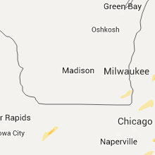
Wisconsin
| Local Time | Report Details |
|---|---|
| 12:45 PM CDT | Quarter sized hail reported near Burlington, WI, 57 miles NNW of Chicago, IL, penny size with a few quarter size. corrected for time of event. |
| 12:55 PM CDT | Quarter sized hail reported near Racine, WI, 57.4 miles N of Chicago, IL |
| 1:00 PM CDT | Quarter sized hail reported near Racine, WI, 58.3 miles N of Chicago, IL, relayed via broadcast media. slightly larger than quarters. time estimated from radar. |
| 1:05 PM CDT | Quarter sized hail reported near Racine, WI, 58.2 miles N of Chicago, IL, nickel to quarter size. lasted 3 to 5 minutes. |
| 1:29 PM CDT | Quarter sized hail reported near Burlington, WI, 57 miles NNW of Chicago, IL, penny size with a few quarter size. |
Kentucky
| Local Time | Report Details |
|---|---|
| 12:55 PM CDT | 3 houses and some outbuildings that have damage along furches trail. numerous large trees uprooted. barn door blown off it. all damage faced to the northeast in calloway county KY, 31.3 miles NNE of Mc Kenzie, TN |
| 1:35 PM CDT | Damage to roof of rural farm home including numerous shingles blown off. damage to property. 70 mph wind estimat in hopkins county KY, 41.4 miles S of Evansville, IN |
| 1:42 PM CDT | Report of large tree limbs down on townsend drive in webster county KY, 33.8 miles S of Evansville, IN |
| 2:00 PM CDT | Several trees uprooted... all laying in same direction. roof completely torn off metal building. several trees are down across the county in muhlenberg county KY, 58.6 miles SSE of Evansville, IN |
| 2:03 PM CDT | Two trees uprooted on kennedy brashar road south of greenville ky in muhlenberg county KY, 59.7 miles SSE of Evansville, IN |
| 2:05 PM CDT | Metal carport was torn off and destroyed. carport was thrown into nearby house and did minimal damage to that homes roo in muhlenberg county KY, 58.8 miles SSE of Evansville, IN |
| 2:05 PM CDT | Approximately 20 to 30 trees down... all in same direction. metal from barns thrown into fiel in daviess county KY, 35.5 miles SE of Evansville, IN |
| 2:10 PM CDT | 2 power poles and a tree snapped at intersection of hwy 231 and old masonville road in daviess county KY, 36.9 miles SE of Evansville, IN |
| 2:15 PM CDT | Power poles and wires down along hwy 54 near the 13 mile marker between whitesville and philpot in daviess county KY, 40.2 miles ESE of Evansville, IN |
| 2:25 PM CDT | Tree down across highway 1700 near quisenberry roa in hancock county KY, 48.1 miles ESE of Evansville, IN |
| 2:40 PM CDT | Roof off the gym at breckinridge county middle school. damage to a nearby gas station. damage to buildings on fairgrounds roa in breckinridge county KY, 42.3 miles WSW of Louisville, KY |
| 2:42 PM CDT | *** 2 inj *** trailers flipped over at nancy butler trailer park. updated for injury repor in breckinridge county KY, 41.3 miles WSW of Louisville, KY |
| 4:15 PM EDT | Large limb down aristides drive... pr in jefferson county KY, 12.7 miles NW of Louisville, KY |
| 4:18 PM EDT | Tree blown on to a house on dubourg avenu in jefferson county KY, 16 miles NNW of Louisville, KY |
| 4:22 PM EDT | Power lines down in shepherdsvill in bullitt county KY, 0.4 miles ENE of Louisville, KY |
| 4:25 PM EDT | Bleachers and goal posts blown over at male high schoo in jefferson county KY, 13.9 miles N of Louisville, KY |
| 4:28 PM EDT | Power lines down on taylor blv in jefferson county KY, 15 miles NNW of Louisville, KY |
| 4:28 PM EDT | Tree on a mobile home on cane run roa in jefferson county KY, 15 miles NW of Louisville, KY |
| 4:28 PM EDT | Power lines down on palatka road near manslick in the iroquois park are in jefferson county KY, 12.7 miles NNW of Louisville, KY |
| 4:28 PM EDT | Large tree down on duncan stree in jefferson county KY, 19.5 miles NNW of Louisville, KY |
| 4:29 PM EDT | Power lines down between shepherdsville and mt. washingto in bullitt county KY, 6.5 miles ENE of Louisville, KY |
| 4:29 PM EDT | Outbuilding damaged near salt river electric on highway 4 in bullitt county KY, 5.2 miles ENE of Louisville, KY |
| 4:30 PM EDT | Pole barn blown apart on hwy 44... 1 mile from alpar lan in bullitt county KY, 5.2 miles ENE of Louisville, KY |
| 4:30 PM EDT | Tree uprooted on midland lan in bullitt county KY, 6.8 miles ENE of Louisville, KY |
| 4:31 PM EDT | Large trees downed across beargrass cree in jefferson county KY, 16.6 miles NNE of Louisville, KY |
| 4:31 PM EDT | Trees down on stony broo in jefferson county KY, 14.1 miles NNE of Louisville, KY |
| 3:42 PM CDT | Trees dow in logan county KY, 46.7 miles N of Nashville, TN |
| 3:46 PM CDT | Spotters report metal coming off barn roof in front of them at 1500 block of hwy 117 just north of fort campbel in christian county KY, 50.5 miles NW of Nashville, TN |
| 4:47 PM EDT | Trees down across the count in spencer county KY, 20.8 miles E of Louisville, KY |
| 4:47 PM EDT | Trees down county wid in spencer county KY, 20.9 miles E of Louisville, KY |
| 4:55 PM EDT | Power pole snapped and power lines down near interstate from strong winds. also received report of tree damage along radcliffe rd sw of this location from state polic in henry county KY, 39.1 miles NE of Louisville, KY |
| 4:58 PM EDT | Flag pole down in far northeastern spencer count in spencer county KY, 32.8 miles E of Louisville, KY |
| 4:09 PM CDT | Tree down on a vehicle on smallhouse roa in warren county KY, 58.3 miles NNE of Nashville, TN |
| 5:17 PM EDT | Large tree down on new liberty pike in owen county KY, 42.3 miles SSW of Cincinnati, OH |
| 4:53 PM CDT | Tree down in northern barren county near the hart county line in barren county KY, 60 miles SSW of Louisville, KY |
| 5:26 PM CDT | Trees and a few power lines down in adair count in adair county KY, 66 miles SSE of Louisville, KY |
| 7:13 PM EDT | A tree was blown down along beasley roa in pulaski county KY, 61 miles SW of Irvine, KY |
| 7:35 PM EDT | A tree was blown down at intersection of east university drive and north main street in pulaski county KY, 55.2 miles SW of Irvine, KY |
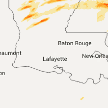
Louisiana
| Local Time | Report Details |
|---|---|
| 2:50 PM CDT | Golf Ball sized hail reported near Provencal, LA, 67.7 miles SSE of Shreveport, LA, golf ball size hail reported in provencal |
| 2:57 PM CDT | Half Dollar sized hail reported near Columbia, LA, 41.7 miles SSW of Bastrop, LA, sheriff office reported half dollar sized hail near corey |
| 3:28 PM CDT | Quarter sized hail reported near Mangham, LA, 33.4 miles SSE of Bastrop, LA, quarter size hail reported. |
| 3:36 PM CDT | Utility pole broken along aj stephens rd in franklin county LA, 35 miles SSE of Bastrop, LA |
| 3:36 PM CDT | Golf Ball sized hail reported near Baskin, LA, 37 miles SSE of Bastrop, LA, so reports golfball size hail in baskin. |
| 3:52 PM CDT | Large oak tree broken and blocking south bound lane of sr-1 in franklin county LA, 35.5 miles SE of Bastrop, LA |
| 3:52 PM CDT | Hen Egg sized hail reported near Delhi, LA, 38.4 miles SE of Bastrop, LA, 2.25 inch size hail |
| 3:52 PM CDT | So reports trees down at hwy 859... rodgers rd and hwy 1 in franklin county LA, 35.3 miles SE of Bastrop, LA |
| 4:00 PM CDT | Half Dollar sized hail reported near Columbia, LA, 39.7 miles SSW of Bastrop, LA, a second severe thunderstorm produced half dollar size hail north of the riverton community near the ouachita parish line. |
| 4:25 PM CDT | Trees and power lines down on highway 146 near the intersection of mosswood drive just south of the lincoln parish lin in jackson county LA, 41.2 miles WSW of Bastrop, LA |
| 4:37 PM CDT | So reports trees and power lines downed on hwy 876 west of wisner in franklin county LA, 56.6 miles SSE of Bastrop, LA |
| 4:37 PM CDT | Half Dollar sized hail reported near Lena, LA, 92.2 miles NNW of Lafayette, LA, public posted photos of half dollar size hail in sharp. time estimated from radar. |
| 4:50 PM CDT | Ping Pong Ball sized hail reported near Coushatta, LA, 45.6 miles SSE of Shreveport, LA, grand bayou resevoir |
| 4:55 PM CDT | Golf Ball sized hail reported near Coushatta, LA, 44.6 miles SE of Shreveport, LA, reported by an off duty nws employee near grand bayou. |
| 5:10 PM CDT | Golf Ball sized hail reported near Pollock, LA, 93 miles SSW of Bastrop, LA, golf ball size hail fell in the bentley community. |
| 5:15 PM CDT | Hen Egg sized hail reported near Pollock, LA, 91.4 miles SSW of Bastrop, LA, between golf ball and tennis ball size hail is covering the ground in pollock. report from the pollock town hall. |
| 5:40 PM CDT | Trees down on holman loop northwest of campt in natchitoches county LA, 51.2 miles SE of Shreveport, LA |
Indiana
| Local Time | Report Details |
|---|---|
| 4:04 PM EDT | Storm damage reported in st. joseph county IN, 69.3 miles E of Chicago, IL |
| 4:27 PM EDT | Tree on a hous in clark county IN, 23.8 miles N of Louisville, KY |
| 4:30 PM EDT | Hollow tree blown down/apart on cedarview driv in clark county IN, 21.5 miles N of Louisville, KY |
| 3:30 PM CDT | Quarter sized hail reported near Chesterton, IN, 35.5 miles ESE of Chicago, IL |
| 5:55 PM EDT | Around 7 trees dow in miami county IN, 48.5 miles WSW of Fort Wayne, IN |
| 6:15 PM EDT | Wind damgage to several mobile homes and barns in and around albio in noble county IN, 27.9 miles NW of Fort Wayne, IN |
| 6:42 PM EDT | Quarter sized hail reported near Bloomington, IN, 45.1 miles SSW of Indianapolis, IN, report via twitter |
| 7:20 PM EDT | Two trees down across highway in the 6100 bock of west 900 south and 8800 block of south 600 west. time estimated from rada in shelby county IN, 31.1 miles SSE of Indianapolis, IN |
Illinois
| Local Time | Report Details |
|---|---|
| 3:29 PM CDT | Quarter sized hail reported near Nashville, IL, 48.4 miles ESE of Saint Louis, MO |
| 3:36 PM CDT | Storm damage reported in marion county IL, 62.2 miles E of Saint Louis, MO |
Ohio
| Local Time | Report Details |
|---|---|
| 5:39 PM EDT | Numerous ash trees knocked dow in clermont county OH, 17.4 miles ENE of Cincinnati, OH |
| 5:39 PM EDT | Tree that is approximately one foot in diameter was knocked dow in franklin county OH, 5.3 miles ESE of Columbus, OH |
| 5:52 PM EDT | Tree down on wolfangel and state roads in anderson townshi in hamilton county OH, 9 miles ESE of Cincinnati, OH |
| 6:26 PM EDT | Roof off barn on miami trace road near us62 in fayette county OH, 44.1 miles SW of Columbus, OH |
| 6:50 PM EDT | Several trees down in pickaway county OH, 27.1 miles SSW of Columbus, OH |
| 7:04 PM EDT | Us-22 at state route 13 in pickaway county OH, 25.7 miles S of Columbus, OH |
| 7:12 PM EDT | Large diameter limb knocked down...time estimated from rada in franklin county OH, 6.8 miles N of Columbus, OH |
| 7:20 PM EDT | Tree that is approximately one foot in diameter was knocked down...time estimated from rada in franklin county OH, 5.3 miles ESE of Columbus, OH |
Michigan
| Local Time | Report Details |
|---|---|
| 5:39 PM EDT | Trees and wires downed in midland county MI, 50.2 miles NNW of Flint, MI |
Georgia
| Local Time | Report Details |
|---|---|
| 6:18 PM EDT | Quarter sized hail reported near Colquitt, GA, 53.5 miles NW of Tallahassee, FL, estimated quarter size hail along highway 45 |
| 7:20 PM EDT | Tree down on butler ferry road in decatur county GA, 37 miles NNW of Tallahassee, FL |
| 7:38 PM EDT | Power lines down near godwin lane and county line road 262. a caller also reported an unconfirmed tornado in that area in grady county GA, 43.4 miles N of Tallahassee, FL |
Texas
| Local Time | Report Details |
|---|---|
| 3:48 AM CDT | Quarter sized hail reported near Brackettville, TX, 29.6 miles E of Del Rio, TX, largest was 1 inch with average .38 inch. |
Connect with Interactive Hail Maps