

Hail Map for Thursday, April 21, 2011

Number of Impacted Households on 4/21/2011
0
Impacted by 1" or Larger Hail
0
Impacted by 1.75" or Larger Hail
0
Impacted by 2.5" or Larger Hail
Square Miles of Populated Area Impacted on 4/21/2011
0
Impacted by 1" or Larger Hail
0
Impacted by 1.75" or Larger Hail
0
Impacted by 2.5" or Larger Hail


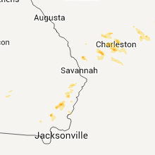
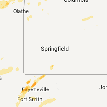


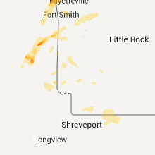
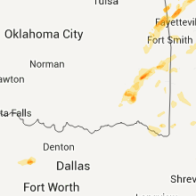

Cities Most Affected by Hail Storms of 4/21/2011
| Hail Size | Demographics of Zip Codes Affected | ||||||
|---|---|---|---|---|---|---|---|
| City | Count | Average | Largest | Pop Density | House Value | Income | Age |
| Charleston, SC | 4 | 1.75 | 1.75 | 2408 | $121k | $37.4k | 37.9 |
| Fayetteville, AR | 2 | 2.25 | 2.75 | 287 | $100k | $31.1k | 26.4 |
| Springdale, AR | 2 | 2.00 | 2.00 | 755 | $90k | $38.9k | 31.4 |
| Trent, TX | 1 | 2.00 | 2.00 | 3 | $34k | $39.4k | 42.5 |
| Lincoln, AR | 1 | 1.75 | 1.75 | 52 | $72k | $29.6k | 37.3 |
| Benton, MS | 1 | 1.75 | 1.75 | 15 | $65k | $27.3k | 42.5 |
| Ozan, AR | 1 | 1.75 | 1.75 | 10 | $39k | $25.2k | 42.3 |
| Westville, OK | 1 | 1.75 | 1.75 | 34 | $48k | $27.1k | 35.9 |
| Eureka Springs, AR | 1 | 1.75 | 1.75 | 89 | $126k | $31.7k | 60.3 |
| Reeds Spring, MO | 1 | 1.75 | 1.75 | 97 | $107k | $29.5k | 47.7 |
| Brunswick, GA | 1 | 1.75 | 1.75 | 299 | $88k | $39.3k | 35.3 |
| Clayton, OK | 1 | 1.75 | 1.75 | 3 | $34k | $20.9k | 43.2 |
| Snow, OK | 1 | 1.75 | 1.75 | 2 | $36k | $33.4k | 49.0 |
| Riceboro, GA | 1 | 1.75 | 1.75 | 11 | $60k | $26.3k | 43.6 |
| Fort Stockton, TX | 1 | 1.75 | 1.75 | 6 | $41k | $27.4k | 36.2 |
| Roby, TX | 1 | 1.75 | 1.75 | 5 | $31k | $31.1k | 41.8 |
| Vicksburg, MS | 1 | 1.75 | 1.75 | 66 | $85k | $31.4k | 37.8 |
Hail and Wind Damage Spotted on 4/21/2011
Filter by Report Type:Hail ReportsWind Reports
States Impacted
Mississippi, Louisiana, Oklahoma, Utah, Arkansas, Texas, Idaho, Alabama, Wyoming, Missouri, South Carolina, Georgia, Colorado, KansasMississippi
| Local Time | Report Details |
|---|---|
| 12:48 PM UTC | Quarter sized hail reported near Bentonia, MS, 31.1 miles NNW of Jackson, MS, observed while traveling on highway 49 |
| 12:49 PM UTC | Golf Ball sized hail reported near Vicksburg, MS, 50.2 miles WNW of Jackson, MS, golfball hail reported in the eagle bend area. |
| 12:56 PM UTC | Golf Ball sized hail reported near Benton, MS, 32.4 miles NNW of Jackson, MS, golfball hail reportedly broke some windows. |
| 5:10 PM UTC | Quarter sized hail reported near Hazlehurst, MS, 28.2 miles SSW of Jackson, MS |
| 6:26 PM UTC | Trees were downed along blackwell rd and hickory little rock r in newton county MS, 68.9 miles E of Jackson, MS |
| 6:28 PM UTC | Multiple trees down across hickory nut rd and hopewell rd in newton county MS, 70 miles S of Starkville, MS |
| 6:29 PM UTC | Multiple trees downed across chunky-duffee rd in newton county MS, 67 miles S of Starkville, MS |
| 6:31 PM UTC | Trees down across ms highway 49 in newton county MS, 66.9 miles S of Starkville, MS |
| 6:49 PM UTC | Several trees down...one of which fell across blind brown road. also...several reports of 50 mph winds in the northwest part of the county in lauderdale county MS, 67.4 miles S of Starkville, MS |
| 7:15 PM UTC | Quarter sized hail reported near Toomsuba, MS, 74.2 miles SSE of Starkville, MS |
Louisiana
| Local Time | Report Details |
|---|---|
| 1:47 PM UTC | Tree down at hwy 9 and forest grove r in claiborne county LA, 49.1 miles ENE of Shreveport, LA |
| 1:48 PM UTC | Several trees down on richardson loop near hwy 9. some trees are blocking the roa in claiborne county LA, 49.1 miles ENE of Shreveport, LA |
| 2:01 PM UTC | Quarter sized hail reported near Lisbon, LA, 54.6 miles ENE of Shreveport, LA |
| 7:51 PM UTC | Quarter sized hail reported near Greensburg, LA, 69 miles NW of New Orleans, LA, hail falling heavy at times at the fire station on highway 37. |
Oklahoma
| Local Time | Report Details |
|---|---|
| 1:50 PM UTC | Quarter sized hail reported near Haworth, OK, 43.3 miles WSW of Nashville, AR, truck driver at a convenience store relayed that he went through hail that was quarter-sized. |
| 5:41 PM UTC | Quarter sized hail reported near Bunch, OK, 27.9 miles NW of Fort Smith, AR |
| 6:12 PM UTC | Golf Ball sized hail reported near Snow, OK, 41.1 miles E of Atoka, OK |
| 7:52 PM UTC | Golf Ball sized hail reported near Clayton, OK, 46.6 miles ENE of Atoka, OK |
| 8:02 PM UTC | Quarter sized hail reported near Clayton, OK, 51 miles ENE of Atoka, OK, lots of small hail with quarter being the largest |
| 8:10 PM UTC | Half Dollar sized hail reported near Vinita, OK, 61.7 miles NE of Tulsa, OK, lot of damage to asphalt shingles. |
| 8:12 PM UTC | Golf Ball sized hail reported near Westville, OK, 42.6 miles N of Fort Smith, AR |
| 9:00 PM UTC | Quarter sized hail reported near Fanshawe, OK, 40.8 miles SW of Fort Smith, AR |
| 10:30 PM UTC | Quarter sized hail reported near Poteau, OK, 25.7 miles SSW of Fort Smith, AR, nickel and quarter size hail reported at auto dealership on south end of town. |
Utah
| Local Time | Report Details |
|---|---|
| 5:00 PM UTC | I-80 mp 1 sensor in tooele county UT, 91.9 miles E of Elko, NV |
| 5:00 PM UTC | Reported at wendover point of entry in tooele county UT, 91.9 miles E of Elko, NV |
| 5:15 PM UTC | Wendover peak sensor in tooele county UT, 91.9 miles E of Elko, NV |
| 5:50 PM UTC | Diddle knoll sensor in tooele county UT, 67 miles W of Salt Lake City, UT |
| 6:10 PM UTC | Upper cedar mountain sensor in tooele county UT, 64.4 miles WSW of Salt Lake City, UT |
| 6:10 PM UTC | Playa station sensor in tooele county UT, 72.8 miles WSW of Salt Lake City, UT |
| 6:30 PM UTC | Snowbasin sensor in morgan county UT, 29.7 miles N of Salt Lake City, UT |
| 6:30 PM UTC | Gunnison island sensor in box elder county UT, 63.8 miles NW of Salt Lake City, UT |
| 6:30 PM UTC | Lakeside mountain sensor in box elder county UT, 56.4 miles WNW of Salt Lake City, UT |
| 6:33 PM UTC | I80 at grassey sensor in tooele county UT, 58.9 miles W of Salt Lake City, UT |
| 6:33 PM UTC | Fish springs sensor in tooele county UT, 94.5 miles ENE of Ely, NV |
| 6:33 PM UTC | Uttr sensor in box elder county UT, 58.6 miles WNW of Salt Lake City, UT |
| 6:33 PM UTC | Camel back mountain station in tooele county UT, 71.3 miles SW of Salt Lake City, UT |
| 6:35 PM UTC | Tower grid sensor in tooele county UT, 71.7 miles SW of Salt Lake City, UT |
| 6:35 PM UTC | Nw decon pad dugway sensor in tooele county UT, 68 miles WSW of Salt Lake City, UT |
| 6:45 PM UTC | Baker lab sensor in tooele county UT, 71.8 miles WSW of Salt Lake City, UT |
| 6:45 PM UTC | Simpson springs dugway in tooele county UT, 80.2 miles SW of Salt Lake City, UT |
| 6:45 PM UTC | English village sensor in tooele county UT, 57.1 miles SW of Salt Lake City, UT |
| 6:45 PM UTC | English village in tooele county UT, 57.1 miles SW of Salt Lake City, UT |
| 6:45 PM UTC | Camel back mountain in tooele county UT, 71.3 miles SW of Salt Lake City, UT |
| 6:50 PM UTC | White sage sensor in tooele county UT, 67.1 miles SW of Salt Lake City, UT |
| 7:05 PM UTC | Lake point sensor in tooele county UT, 20.1 miles WSW of Salt Lake City, UT |
| 7:10 PM UTC | Trees down in tremonton. windows blown out in vehicle in box elder county UT, 68 miles NNW of Salt Lake City, UT |
| 7:14 PM UTC | Salt lake city airport sensor in salt lake county UT, 4.5 miles WNW of Salt Lake City, UT |
| 7:15 PM UTC | Ditto in tooele county UT, 67.5 miles SW of Salt Lake City, UT |
| 7:15 PM UTC | Vernon hill sensor in tooele county UT, 50.6 miles SSW of Salt Lake City, UT |
| 7:15 PM UTC | Light pole fell on 2 cars at salt lake international airport in salt lake county UT, 4.5 miles WNW of Salt Lake City, UT |
| 7:20 PM UTC | Baccus sensor in salt lake county UT, 13 miles SW of Salt Lake City, UT |
| 7:20 PM UTC | Multiple trees down in the ogden are in weber county UT, 32.7 miles N of Salt Lake City, UT |
| 7:20 PM UTC | Multiple trees down. powerlines reported down across the count in weber county UT, 39.1 miles N of Salt Lake City, UT |
| 7:24 PM UTC | Storm damage reported in utah county UT, 31.3 miles S of Salt Lake City, UT |
| 7:25 PM UTC | Large trees down in rose park in salt lake county UT, 4.8 miles WNW of Salt Lake City, UT |
| 7:26 PM UTC | A parked small privately owned air plane was flipped over by the strong winds at the bountiful airpor in davis county UT, 7.7 miles N of Salt Lake City, UT |
| 7:30 PM UTC | Odgen peak - ogp 9570 ft in weber county UT, 30.4 miles N of Salt Lake City, UT |
| 7:30 PM UTC | Parleys canyon at q in salt lake county UT, 6.5 miles ESE of Salt Lake City, UT |
| 7:30 PM UTC | At least two dozen large trees down in huntsville. several of the down trees damaged structures with one house with moderate damage. many powerlines dow in weber county UT, 35.1 miles N of Salt Lake City, UT |
| 7:30 PM UTC | 18-24 inch diameter tree snapped and landed on house causing minor roof damage in the avenues in salt lake county UT, 3 miles NW of Salt Lake City, UT |
| 8:02 PM UTC | Semi truck blown over in salt lake county UT, 3.3 miles WNW of Salt Lake City, UT |
Arkansas
| Local Time | Report Details |
|---|---|
| 6:27 PM UTC | Golf Ball sized hail reported near Lincoln, AR, 39 miles N of Fort Smith, AR |
| 6:55 PM UTC | Quarter sized hail reported near Siloam Springs, AR, 54.6 miles N of Fort Smith, AR |
| 1:55 PM CDT | Golf Ball sized hail reported near Fayetteville, AR, 49.3 miles NNE of Fort Smith, AR, on mt comfort road northwest of fayetteville |
| 7:00 PM UTC | Hen Egg sized hail reported near Springdale, AR, 55.3 miles NNE of Fort Smith, AR, reported at johnson exit on i-540. also report of broken windows of parked cars at bank in johnson. |
| 2:00 PM CDT | Baseball sized hail reported near Fayetteville, AR, 48.8 miles NNE of Fort Smith, AR, reported on the west side of town. relayed via broadcast media. hail was measured with calipers. |
| 7:04 PM UTC | Hen Egg sized hail reported near Springdale, AR, 57.9 miles NNE of Fort Smith, AR |
| 2:05 PM CDT | Quarter sized hail reported near Fayetteville, AR, 48.8 miles NNE of Fort Smith, AR, quarter sized and larger hail causing cars to slide off the road on 540 near mile marker 67. |
| 7:05 PM UTC | Ping Pong Ball sized hail reported near Johnson, AR, 53.3 miles NNE of Fort Smith, AR, photo of the hail showed its diameter was almost the width of two nickels. |
| 7:26 PM UTC | Quarter sized hail reported near Rogers, AR, 67.3 miles NNE of Fort Smith, AR |
| 7:35 PM UTC | Golf Ball sized hail reported near Eureka Springs, AR, 61.2 miles SSW of Springfield, MO |
| 7:47 PM UTC | Quarter sized hail reported near Eureka Springs, AR, 61 miles SSW of Springfield, MO, lots of pea and nickel but some as large as a quarter. |
| 8:00 PM UTC | Golf Ball sized hail reported near Ozan, AR, 2 miles SE of Nashville, AR |
Texas
| Local Time | Report Details |
|---|---|
| 6:44 PM UTC | Ping Pong Ball sized hail reported near Moran, TX, 37 miles E of Abilene, TX, cocorahs report indicated ping pong size hail |
| 9:20 PM UTC | Golf Ball sized hail reported near Fort Stockton, TX, 67 miles ENE of Alpine, TX, reported along highway 285. |
| 11:04 PM UTC | 50 knot wind gust measured at dryden aso in terrell county TX, 87.3 miles WNW of Del Rio, TX |
| 11:59 PM UTC | Golf Ball sized hail reported near Roby, TX, 41.1 miles WNW of Abilene, TX, hail ranging dimes up to the size of golfballs fell from 645pm to 715 pm. |
| 8:10 PM CDT | Ping Pong Ball sized hail reported near Rotan, TX, 50.7 miles WNW of Abilene, TX, ping pong ball size hail in rotan |
| 1:19 AM UTC | Hen Egg sized hail reported near Trent, TX, 24.1 miles WNW of Abilene, TX, hail from goflball to hen egg size 7 miles north of trent |
| 3:21 AM UTC | Quarter sized hail reported near Chillicothe, TX, 41.7 miles ESE of Childress, TX |
| 4:00 AM UTC | Quarter sized hail reported near Bridgeport, TX, 65.6 miles WNW of Dallas, TX, quarter size hail in boonsville |
| 4:44 AM UTC | Quarter sized hail reported near Del Rio, TX, 15.7 miles NW of Del Rio, TX, quarter size hail reported by border patrol. |
Idaho
| Local Time | Report Details |
|---|---|
| 6:47 PM UTC | Storm damage reported in power county ID, 67.1 miles WSW of Idaho Falls, ID |
| 6:50 PM UTC | Storm damage reported in butte county ID, 49.6 miles W of Idaho Falls, ID |
| 6:50 PM UTC | Storm damage reported in bingham county ID, 38.8 miles W of Idaho Falls, ID |
Alabama
| Local Time | Report Details |
|---|---|
| 7:36 PM UTC | Top of a tree blown onto us highway 11 just north of yor in sumter county AL, 67.7 miles WNW of Camden, AL |
| 8:47 PM UTC | Storm spotter reported 60 mph in needha in choctaw county AL, 61.6 miles W of Camden, AL |
Wyoming
| Local Time | Report Details |
|---|---|
| 8:20 PM UTC | Storm damage reported in uinta county WY, 59.5 miles NE of Salt Lake City, UT |
| 8:31 PM UTC | Storm damage reported in uinta county WY, 70.6 miles ENE of Salt Lake City, UT |
Missouri
| Local Time | Report Details |
|---|---|
| 8:35 PM UTC | Golf Ball sized hail reported near Reeds Spring, MO, 31.3 miles S of Springfield, MO |
| 10:50 AM UTC | Quarter sized hail reported near Liberty, MO, 12.9 miles NE of Kansas City, MO |
South Carolina
| Local Time | Report Details |
|---|---|
| 8:52 PM UTC | Quarter sized hail reported near Ridgeville, SC, 11.5 miles WSW of Charleston, SC |
| 8:55 PM UTC | Quarter sized hail reported near Summerville, SC, 17.2 miles SW of Charleston, SC |
| 9:00 PM UTC | Quarter sized hail reported near Summerville, SC, 8.6 miles SW of Charleston, SC, quarter sized hail reported in cane bay plantation. |
| 9:02 PM UTC | Ping Pong Ball sized hail reported near Summerville, SC, 16 miles SSW of Charleston, SC |
| 9:20 PM UTC | Quarter sized hail reported near Charleston, SC, 25.4 miles S of Charleston, SC, quarter sized hail reported along glen oaks court. |
| 5:22 PM EDT | Golf Ball sized hail reported near Charleston, SC, 27.3 miles S of Charleston, SC, golf ball size hail reported at the grand oaks subdivision in west ashley |
| 9:25 PM UTC | Quarter sized hail reported near Charleston, SC, 24.8 miles S of Charleston, SC, quarter sized hail reported along bayhill drive. |
| 5:25 PM EDT | Golf Ball sized hail reported near Charleston, SC, 27.3 miles S of Charleston, SC, golf ball size hail reported near 61 and wallenberg drive in west ashley |
| 5:30 PM EDT | Golf Ball sized hail reported near Charleston, SC, 27.3 miles S of Charleston, SC |
| 9:30 PM UTC | Quarter sized hail reported near Charleston, SC, 26.6 miles S of Charleston, SC, the public reported quarter size hail at the village square. several cars had light to moderate hail damage. |
| 9:30 PM UTC | Golf Ball sized hail reported near Charleston, SC, 26.6 miles S of Charleston, SC, golf ball sized hail reported along raul wallenberg blvd. |
| 5:31 PM EDT | Ping Pong Ball sized hail reported near Charleston, SC, 27.3 miles S of Charleston, SC, hail up to ping pong ball size reported along foster st. |
| 9:40 PM UTC | Quarter sized hail reported near Charleston, SC, 28.2 miles S of Charleston, SC, quarter sized hail reported at johnson hagood stadium. |
| 10:40 PM UTC | Half Dollar sized hail reported near Wadmalaw Island, SC, 38.9 miles SSW of Charleston, SC, quarter to half dollar size hail reported along bears bluff rd. |
Georgia
| Local Time | Report Details |
|---|---|
| 9:45 PM UTC | Golf Ball sized hail reported near Brunswick, GA, 57.5 miles SW of Savannah, GA, golf ball size hail reported in everett. |
| 10:01 PM UTC | Golf Ball sized hail reported near Riceboro, GA, 34.8 miles SSW of Savannah, GA, the public reported golf ball size hail lasting 3 minutes. |
| 10:45 PM UTC | Quarter sized hail reported near Waynesville, GA, 64.9 miles ESE of Douglas, GA, the public reported quarter size hail that lasted for 15 minutes. the hail covered the ground and knocked down a lot of tree limbs. |
| 11:10 PM UTC | Quarter sized hail reported near Richmond Hill, GA, 16.3 miles SW of Savannah, GA, penny to quarter size hail located along hwy 144 near rabbit hill. |
| 11:15 PM UTC | Ping Pong Ball sized hail reported near Richmond Hill, GA, 16.3 miles SW of Savannah, GA, hail to ping pong ball size reported along charlies rd near rabbit hill. |
Colorado
| Local Time | Report Details |
|---|---|
| 3:15 AM UTC | Greeley airport in weld county CO, 47.4 miles N of Denver, CO |
Kansas
| Local Time | Report Details |
|---|---|
| 8:59 AM UTC | Quarter sized hail reported near Burlingame, KS, 49.3 miles SE of Manhattan, KS |
| 9:25 AM UTC | Quarter sized hail reported near Berryton, KS, 53.7 miles WSW of Kansas City, MO, a few quarters but mostly penny to nickel sized hail. time estimated. |
| 9:54 AM UTC | Quarter sized hail reported near McLouth, KS, 33.8 miles W of Kansas City, MO |
| 10:10 AM UTC | Quarter sized hail reported near Basehor, KS, 18.7 miles W of Kansas City, MO |
Connect with Interactive Hail Maps