

Hail Map for Tuesday, April 24, 2012

Number of Impacted Households on 4/24/2012
0
Impacted by 1" or Larger Hail
0
Impacted by 1.75" or Larger Hail
0
Impacted by 2.5" or Larger Hail
Square Miles of Populated Area Impacted on 4/24/2012
0
Impacted by 1" or Larger Hail
0
Impacted by 1.75" or Larger Hail
0
Impacted by 2.5" or Larger Hail


Cities Most Affected by Hail Storms of 4/24/2012
| Hail Size | Demographics of Zip Codes Affected | ||||||
|---|---|---|---|---|---|---|---|
| City | Count | Average | Largest | Pop Density | House Value | Income | Age |
| Orofino, ID | 1 | 1.75 | 1.75 | 15 | $86k | $32.2k | 47.2 |
| Joplin, MO | 1 | 1.75 | 1.75 | 583 | $68k | $30.4k | 35.1 |
Hail and Wind Damage Spotted on 4/24/2012
Filter by Report Type:Hail ReportsWind Reports
Wyoming
| Local Time | Report Details |
|---|---|
| 1:30 PM MDT | Storm damage reported in platte county WY, 55.2 miles NE of Laramie, WY |
Nevada
| Local Time | Report Details |
|---|---|
| 2:11 PM PDT | 7984 feet amsl... quima peak raws in nye county NV, 130 miles WSW of Ely, NV |
Idaho
| Local Time | Report Details |
|---|---|
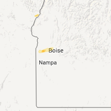
| 3:30 PM MDT | Quarter sized hail reported near Caldwell, ID, 26.3 miles WNW of Boise, ID |
| 3:45 PM MDT | Half Dollar sized hail reported near Eagle, ID, 16.3 miles NW of Boise, ID, half dollar size hail and gusts to 75 mph. |
| 3:43 PM PDT | Quarter sized hail reported near Clark Fork, ID, 66.9 miles ENE of Spokane, WA |
| 3:43 PM PDT | Quarter sized hail reported near Clark Fork, ID, 67.3 miles ENE of Spokane, WA |
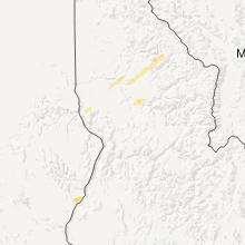
| 5:00 PM PDT | Half Dollar sized hail reported near Pierce, ID, 43.8 miles NNE of Grangeville, ID, trained weather spotter reported 1 1/4 inch hail along with some wind damage |
| 8:00 PM PDT | Golf Ball sized hail reported near Orofino, ID, 38.8 miles N of Grangeville, ID, trained spotter reported golf ball size hail in orofino |
| 8:05 PM PDT | Quarter sized hail reported near Orofino, ID, 40.7 miles N of Grangeville, ID, trained spotter reported 1 inch hail 3 miles ne of orofino |
| 8:10 PM PDT | Quarter sized hail reported near Orofino, ID, 40.3 miles N of Grangeville, ID, trained spotter reported quarter size hail 2 miles nw of orofino |
| 8:10 PM PDT | Half Dollar sized hail reported near Orofino, ID, 42.5 miles N of Grangeville, ID, trained spotter reported half dollar size hail 5 ne of orofino |
Montana
| Local Time | Report Details |
|---|---|
| 6:02 PM MDT | 58 mph thunderstorm wind gust reported at the two medicine bridge mt dot sit in glacier county MT, 52.4 miles E of Whitefish, MT |
Nebraska
| Local Time | Report Details |
|---|---|
| 6:25 PM MDT | Two car garage completely demolished and a 12 inch diameter pine tree in the yard snapped in half 8 feet above the groun in keith county NE, 43.7 miles W of North Platte, NE |
| 6:25 PM MDT | Two power poles were bent over at a 45 degree angles due to straight line wind in keith county NE, 43.7 miles W of North Platte, NE |
| 6:25 PM MDT | *** 1 inj *** semi-trailer blown off interstate 80 mile marker 134. wind speed is estimate in keith county NE, 43.7 miles W of North Platte, NE |
| 6:25 PM MDT | Semi-trailer blown over at construction site along with barricades. wind speed is estimate in keith county NE, 43.7 miles W of North Platte, NE |
| 6:28 PM MDT | *** 1 inj *** car blown off interstate 80 at mile marker 137 due to straight line wind in keith county NE, 39.5 miles W of North Platte, NE |
Kansas
| Local Time | Report Details |
|---|---|
| 7:44 PM CDT | Storm damage reported in logan county KS, 22.6 miles SSE of Colby, KS |
| 7:44 PM CDT | Storm damage reported in thomas county KS, 2.3 miles N of Colby, KS |
| 7:48 PM CDT | Storm damage reported in gove county KS, 29.3 miles SE of Colby, KS |
| 8:31 PM CDT | Storm damage reported in gove county KS, 48.7 miles SE of Colby, KS |
Texas
| Local Time | Report Details |
|---|---|
| 8:18 PM CDT | West texas mesonet report in bailey county TX, 65.8 miles NW of Lubbock, TX |
| 8:45 PM CDT | West texas mesonet report in lamb county TX, 43 miles NW of Lubbock, TX |
| 9:30 PM CDT | 1 power pole snapped and 2 other power poles bent. time estimate in lamb county TX, 24.5 miles NW of Lubbock, TX |
Missouri
| Local Time | Report Details |
|---|---|
| 12:30 AM CDT | Golf Ball sized hail reported near Joplin, MO, 63.9 miles W of Springfield, MO, report relayed through 911 center. |
Connect with Interactive Hail Maps