

Hail Map for Wednesday, April 24, 2019

Number of Impacted Households on 4/24/2019
0
Impacted by 1" or Larger Hail
0
Impacted by 1.75" or Larger Hail
0
Impacted by 2.5" or Larger Hail
Square Miles of Populated Area Impacted on 4/24/2019
0
Impacted by 1" or Larger Hail
0
Impacted by 1.75" or Larger Hail
0
Impacted by 2.5" or Larger Hail

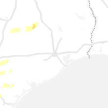


Cities Most Affected by Hail Storms of 4/24/2019
| Hail Size | Demographics of Zip Codes Affected | ||||||
|---|---|---|---|---|---|---|---|
| City | Count | Average | Largest | Pop Density | House Value | Income | Age |
| Bryan, TX | 1 | 1.75 | 1.75 | 47 | $109k | $44.5k | 38.5 |
Hail and Wind Damage Spotted on 4/24/2019
Filter by Report Type:Hail ReportsWind Reports
Texas
| Local Time | Report Details |
|---|---|
| 8:13 AM CDT | Quarter sized hail reported near Christoval, TX, 100.5 miles SSW of Abilene, TX |
| 11:15 AM CDT | Quarter sized hail reported near Kerrville, TX, 55.6 miles NW of San Antonio, TX |
| 3:11 PM CDT | Trained spotter estimated 50 to 60 mph thunderstorm wind gusts in leande in williamson county TX, 38.9 miles S of Killeen, TX |
| 3:20 PM CDT | Public report of estimated 60 mph thunderstorm wind gus in williamson county TX, 35 miles S of Killeen, TX |
| 3:20 PM CDT | Large tree blown down on leander road just west of ih-35. time of event estimated with rada in williamson county TX, 34.3 miles S of Killeen, TX |
| 3:25 PM CDT | Received pictures of fences blown down as well as a small tree... via twitte in williamson county TX, 37.3 miles SSW of Killeen, TX |
| 3:30 PM CDT | Storm spotter reported multiple medium sized trees knocked down and damage to shingles on a roo in williamson county TX, 39.2 miles SSW of Killeen, TX |
| 5:33 PM CDT | 2 power poles down just north of george west in live oak county TX, 57.6 miles NW of Corpus Christi, TX |
| 5:35 PM CDT | Golf Ball sized hail reported near Bryan, TX, 80.7 miles ESE of Killeen, TX, public report of hail estimated to golf ball size just se of hwy 6 and osr. |
| 6:00 PM CDT | Several trees blown down... minor roof damage. time of event estimated with rada in dewitt county TX, 67.4 miles ESE of San Antonio, TX |
Missouri
| Local Time | Report Details |
|---|---|
| 2:50 PM CDT | Tin peeled back on 2 barns. scattered trees down. one outbuilding lost tin roo in cape girardeau county MO, 12.5 miles WSW of Cape Girardeau, MO |
Illinois
| Local Time | Report Details |
|---|---|
| 3:51 PM CDT | Quarter sized hail reported near Olive Branch, IL, 15 miles SE of Cape Girardeau, MO |
Utah
| Local Time | Report Details |
|---|---|
| 7:10 PM MDT | Fish springs - 4282 ft in juab county UT, 94.5 miles ENE of Ely, NV |
Louisiana
| Local Time | Report Details |
|---|---|
| 11:52 PM CDT | Sheriff department report trees down on sundown drive... just east of mooringspor in caddo county LA, 17 miles NW of Shreveport, LA |
| 1:02 AM CDT | Sheriff department reports snapped power pole on hwy 15 in bienville county LA, 40.1 miles ESE of Shreveport, LA |
| 1:12 AM CDT | Trees were downed along the 4300 block of highway 485 north of robelin in natchitoches county LA, 56.7 miles SSE of Shreveport, LA |
| 2:05 AM CDT | Multiple trees and power lines down in downsville area. possible tornad in union county LA, 30.6 miles WSW of Bastrop, LA |
| 2:30 AM CDT | Numerous trees down in the linville community. trees down on homes... with a resident trapped in their home. possible tornad in union county LA, 16.6 miles WNW of Bastrop, LA |
| 2:47 AM CDT | Trees down at norman harper road and white arkansas roa in morehouse county LA, 15.6 miles NNW of Bastrop, LA |
| 3:10 AM CDT | Trees down on mosquito drive in the searcy communit in la salle county LA, 75.7 miles SSW of Bastrop, LA |
Arkansas
| Local Time | Report Details |
|---|---|
| 2:50 AM CDT | Trees down on ashley road 201 wes in ashley county AR, 16 miles N of Bastrop, LA |
| 2:52 AM CDT | A tree and light pole was blown down on highway 133 s and ashley county road 4. a tractor-trailer struck the tree that is across the roadway. several county roads are b in ashley county AR, 19.5 miles N of Bastrop, LA |
Connect with Interactive Hail Maps