

Hail Map for Friday, April 26, 2019

Number of Impacted Households on 4/26/2019
0
Impacted by 1" or Larger Hail
0
Impacted by 1.75" or Larger Hail
0
Impacted by 2.5" or Larger Hail
Square Miles of Populated Area Impacted on 4/26/2019
0
Impacted by 1" or Larger Hail
0
Impacted by 1.75" or Larger Hail
0
Impacted by 2.5" or Larger Hail


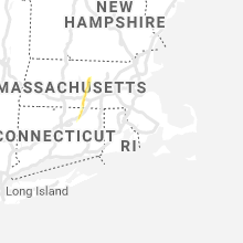


Cities Most Affected by Hail Storms of 4/26/2019
| Hail Size | Demographics of Zip Codes Affected | ||||||
|---|---|---|---|---|---|---|---|
| City | Count | Average | Largest | Pop Density | House Value | Income | Age |
| Warren, MA | 1 | 1.75 | 1.75 | 0 | $113k | $37.3k | 39.5 |
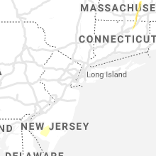
Hail and Wind Damage Spotted on 4/26/2019
Filter by Report Type:Hail ReportsWind Reports
States Impacted
West Virginia, North Carolina, Virginia, Pennsylvania, Maryland, Connecticut, Massachusetts, District of Columbia, Utah, New Mexico, Wyoming, Delaware, New Jersey, Colorado, Nebraska, KansasWest Virginia
| Local Time | Report Details |
|---|---|
| 9:56 AM EDT | *** corrected time *** damage report corresponds with earlier wind... and not recent convectio in roane county WV, 19.1 miles NE of Charleston, WV |
| 6:51 PM EDT | Quarter sized hail reported near Given, WV, 26.7 miles N of Charleston, WV, via twitter with picture. heavy hail accumulation in cowl of car. largest hail stones appear to be near 1" diameter... majority of stones appear near penny-sized. time |
| 7:00 PM EDT | Tree down across puckett ridge rd near parkersburg rd. time est via rada in jackson county WV, 35.3 miles N of Charleston, WV |
| 7:25 PM EDT | 91 customers without power north of frame. official reason given was tree out of row. time est via rada in roane county WV, 16.8 miles NNE of Charleston, WV |
| 7:26 PM EDT | Power outage reported due to tree out of row. reported time was long after storm had passed. time est via rada in roane county WV, 19.1 miles NE of Charleston, WV |
North Carolina
| Local Time | Report Details |
|---|---|
| 11:25 AM EDT | Estimated 60 mph wind gust with pea size hai in hertford county NC, 69.5 miles WSW of Virginia Beach, VA |
| 11:30 AM EDT | Tree blocking lane of traffic on vaughans creek rd. time estimated from rada in hertford county NC, 61.6 miles WSW of Virginia Beach, VA |
| 11:41 AM EDT | Tree down in bowles place dr. time estimated from rada in hertford county NC, 57 miles WSW of Virginia Beach, VA |
| 11:41 AM EDT | Piney island reports wind gust to 53 knot in amz137 county NC, 99.5 miles ENE of Wilmington, NC |
| 11:45 AM EDT | Trees down. reported at tunish rd winton... nc. time estimated from rada in hertford county NC, 53 miles WSW of Virginia Beach, VA |
| 11:50 AM EDT | Trees down. reported at cofield... nc. time estimated from rada in hertford county NC, 54.6 miles WSW of Virginia Beach, VA |
| 12:00 PM EDT | Trees down on water plant rd. in gates... nc. time estimated from rada in gates county NC, 43.5 miles WSW of Virginia Beach, VA |
| 12:15 PM EDT | Ping Pong Ball sized hail reported near Sunbury, NC, 39.4 miles WSW of Virginia Beach, VA, time estimated from radar. |
| 2:25 PM EDT | Tree downed across south dekalb s in cleveland county NC, 39.9 miles W of Charlotte, NC |
| 3:00 PM EDT | Tree and utility lines downed along tate st in gaston county NC, 13.2 miles NW of Charlotte, NC |
| 3:20 PM EDT | Tree downed along sam newell r in mecklenburg county NC, 9.2 miles SE of Charlotte, NC |
| 3:21 PM EDT | Pamlico sound weatherflow station reported a 51 knot wind gus in amz135 county NC, 92.2 miles S of Virginia Beach, VA |
| 3:50 PM EDT | Jennettes pier weatherflow station reported a 55 knot wind gus in amz150 county NC, 63.9 miles SSE of Virginia Beach, VA |
| 3:53 PM EDT | Johnston county 911 received report of tree down at smith rd and water oak dr west of smithfiel in johnston county NC, 19.9 miles SSE of Raleigh, NC |
| 4:02 PM EDT | Johnston county 911 received report of tree down across roadway at 3030 hwy 42e near neuse colony subdivision in clayto in johnston county NC, 17.5 miles ESE of Raleigh, NC |
| 4:26 PM EDT | 40 ft tree branch in the road at 1522 branch st. time estimated from rada in wilson county NC, 40.2 miles E of Raleigh, NC |
| 4:30 PM EDT | Strong winds lifted up a carport and dropped it down onto a motorcycle and ca in richmond county NC, 62.9 miles ESE of Charlotte, NC |
| 4:47 PM EDT | Edgecombe county 911 received report of 1 tree down across roadway at nc 122 s near lily pad lane in pinetop in edgecombe county NC, 56.9 miles E of Raleigh, NC |
| 5:41 PM EDT | Trees down along highway 210 in far nw bladen county near the cumberland county border in bladen county NC, 52.3 miles NW of Wilmington, NC |
Virginia
| Local Time | Report Details |
|---|---|
| 12:00 PM EDT | Trees down along e griffin s in isle of wight county VA, 37.9 miles W of Virginia Beach, VA |
| 12:20 PM EDT | Trees down carolina rd and routree rd. more reports of trees down across southern suffol in city of suffolk county VA, 31.4 miles WSW of Virginia Beach, VA |
| 1:10 PM EDT | Trees dow in city of chesapeake county VA, 11.9 miles SW of Virginia Beach, VA |
| 1:18 PM EDT | Tree down next to driveway of residenc in albemarle county VA, 53.4 miles WNW of Richmond, VA |
| 1:24 PM EDT | Multiple large trees blown down along james anderson highway in the saint joy area. time estimated from rada in buckingham county VA, 54.3 miles W of Richmond, VA |
| 1:28 PM EDT | Tree down on power lines at 1300 polo grounds rd in albemarle county VA, 60.4 miles NW of Richmond, VA |
| 1:41 PM EDT | Tree down blocking one lane near intersection of stony point rd and burnly station rd in albemarle county VA, 57.9 miles NW of Richmond, VA |
| 1:43 PM EDT | Numerous trees were down in barboursvill in orange county VA, 57.4 miles NW of Richmond, VA |
| 1:58 PM EDT | Tree down along union mills rd in albemarle county VA, 50 miles NW of Richmond, VA |
| 2:05 PM EDT | Tree down on mount pony roa in culpeper county VA, 65.3 miles NNW of Richmond, VA |
| 2:10 PM EDT | Numerous trees down across orange count in orange county VA, 51.1 miles NNW of Richmond, VA |
| 2:16 PM EDT | Trees down along the 6100 block of sumerduck roa in fauquier county VA, 67.6 miles N of Richmond, VA |
| 2:18 PM EDT | Tree uprooted and power lines down at the intersection of richmond st. and 1st st. time estimated from rada in louisa county VA, 37.7 miles NNW of Richmond, VA |
| 2:21 PM EDT | Tree down near the intersection of lewiston road and boggs driv in spotsylvania county VA, 40.9 miles N of Richmond, VA |
| 2:24 PM EDT | Numerous trees were down in the locust grove are in orange county VA, 56.3 miles N of Richmond, VA |
| 2:25 PM EDT | Tree down near the intersection of fitzwater drive and bittle lan in prince william county VA, 66.7 miles SW of Baltimore, MD |
| 2:29 PM EDT | Several large trees down... including one onto a carport and another on wires that snapped a pol in spotsylvania county VA, 48.1 miles N of Richmond, VA |
| 2:30 PM EDT | Trees down in spotsylvania courthouse in spotsylvania county VA, 48.1 miles N of Richmond, VA |
| 2:38 PM EDT | Tree down in the 14600 block of aden roa in prince william county VA, 63.8 miles SW of Baltimore, MD |
| 2:45 PM EDT | Several large branches down including in the 1100 block of charles street and near the intersection of kenmore avenue and hanover stree in city of fredericks county VA, 55.6 miles N of Richmond, VA |
| 2:48 PM EDT | Storm damage reported in prince william county VA, 65.5 miles SW of Baltimore, MD |
| 3:08 PM EDT | A tree was down along fort hunt road and paul spring road. a tree limb four inches in diameter was down along the george washington memorial parkway and morningside lan in fairfax county VA, 44.2 miles SSW of Baltimore, MD |
| 3:09 PM EDT | King george elementary school mesone in king george county VA, 58.7 miles NNE of Richmond, VA |
| 3:12 PM EDT | Trees down. time estimated from rada in henrico county VA, 15.5 miles E of Richmond, VA |
| 3:41 PM EDT | Quarter sized hail reported near Suffolk, VA, 26.7 miles WNW of Virginia Beach, VA |
| 3:46 PM EDT | Mesonet station dw5558 suffol in city of suffolk county VA, 29 miles W of Virginia Beach, VA |
| 3:54 PM EDT | Mesonet station domv2 dominion termina in anz638 county VA, 24.5 miles NW of Virginia Beach, VA |
| 3:55 PM EDT | Wind of 60 mph or greater reported by spotte in city of hampton county VA, 22.4 miles NW of Virginia Beach, VA |
| 3:58 PM EDT | Mesonet station xhmp hampton flat in anz638 county VA, 22.8 miles NW of Virginia Beach, VA |
| 3:58 PM EDT | Trees dow in northumberland county VA, 67 miles ENE of Richmond, VA |
| 4:03 PM EDT | Trees dow in mathews county VA, 53.5 miles NNW of Virginia Beach, VA |
| 4:59 PM EDT | Mesonet station xclt chesapeake light towe in anz656 county VA, 21.8 miles ENE of Virginia Beach, VA |
| 6:27 PM EDT | Tree down near the intersection of delaney road and pearson driv in prince william county VA, 59.5 miles SW of Baltimore, MD |
Pennsylvania
| Local Time | Report Details |
|---|---|
| 12:24 PM EDT | Tree and wires down on cedar creek rd in westmoreland county PA, 22.1 miles SSE of Pittsburgh, PA |
| 12:41 PM EDT | Multiple trees down on oakford park rd in westmoreland county PA, 22.9 miles ESE of Pittsburgh, PA |
| 12:44 PM EDT | Tree down on grove st in westmoreland county PA, 25.5 miles ESE of Pittsburgh, PA |
| 12:47 PM EDT | Trees down at route 119 and cameo ln in westmoreland county PA, 27.1 miles ESE of Pittsburgh, PA |
| 12:50 PM EDT | Tree and wires down on buffenmeyer rd in westmoreland county PA, 30.2 miles ESE of Pittsburgh, PA |
| 12:57 PM EDT | Roof off house on keystone park rd. numerous trees down in the are in westmoreland county PA, 32.3 miles E of Pittsburgh, PA |
| 12:58 PM EDT | Storm damage reported in westmoreland county PA, 34.3 miles ESE of Pittsburgh, PA |
| 1:02 PM EDT | Tree and wires down on matson r in westmoreland county PA, 39.9 miles ESE of Pittsburgh, PA |
| 1:11 PM EDT | Tree down on route 259 in westmoreland county PA, 44.8 miles E of Pittsburgh, PA |
| 4:00 PM EDT | A few dozen trees downed or snapped near camp hebron. time estimated by rada in dauphin county PA, 56.9 miles ESE of State College, PA |
| 4:02 PM EDT | One dozen trees down at back rd and radel rd in wayne twp. time estimated by rada in dauphin county PA, 58.9 miles ESE of State College, PA |
| 4:06 PM EDT | Roof partially blown off of barn. time estimated from rada in dauphin county PA, 59.8 miles ESE of State College, PA |
| 4:41 PM EDT | Tree down near intersection of ellicott road and cooper road. time estimated from rada in chester county PA, 57 miles NE of Baltimore, MD |
| 4:44 PM EDT | A large tree damaged a home and trapped two inside. no injuries reported. time estimated from rada in chester county PA, 57.4 miles NE of Baltimore, MD |
| 5:14 PM EDT | Downed tree on wires near the intersection of middletown road and forge road in middletown twp. time estimated from rada in delaware county PA, 76 miles NE of Baltimore, MD |
| 5:29 PM EDT | Downed tree at intersection of manoa road and trent road. time estimated from rada in montgomery county PA, 84 miles SW of Brooklyn, NY |
| 5:30 PM EDT | Downed tree blocking the roadway near the intersection of bowman avenue and kenmore road. time estimated from rada in montgomery county PA, 82.3 miles SW of Brooklyn, NY |
| 5:30 PM EDT | Train stuck due to trees and wires down on the septa tracks near bryn mawr. time estimated from rada in montgomery county PA, 84.1 miles WSW of Brooklyn, NY |
| 5:31 PM EDT | Downed tree near the intersection of forrest avenue and windsor avenue. time estimated from rada in montgomery county PA, 81.9 miles SW of Brooklyn, NY |
| 5:31 PM EDT | Several trees and power lines down in bala cynwyd. time estimated from rada in montgomery county PA, 80.2 miles SW of Brooklyn, NY |
| 5:31 PM EDT | Downed tree at midfield road and lakeside road intersection... with roads blocked. time estimated from rada in montgomery county PA, 83.2 miles SW of Brooklyn, NY |
| 5:33 PM EDT | Downed trees at and near boone park. time estimated from rada in philadelphia county PA, 79.8 miles SW of Brooklyn, NY |
| 5:40 PM EDT | Downed tree on cheltenham avenue near the broad street intersection. time estimated from rada in philadelphia county PA, 74.7 miles SW of Brooklyn, NY |
| 5:42 PM EDT | Downed trees and power lines near melrose park station. time estimated from rada in montgomery county PA, 74.3 miles SW of Brooklyn, NY |
| 5:44 PM EDT | Tree uprooted and blocking the roadway near the intersection of twining road and dale road. time estimated from rada in philadelphia county PA, 76.4 miles SW of Brooklyn, NY |
| 5:45 PM EDT | Downed tree near the intersection of montgomery avenue and central avenue. time estimated from rada in montgomery county PA, 71.8 miles SW of Brooklyn, NY |
| 5:45 PM EDT | Trees down. time estimated from rada in bucks county PA, 67.3 miles SSE of Scranton, PA |
| 5:49 PM EDT | Several trees and a few power lines down in warminster. time estimated from rada in bucks county PA, 67.3 miles WSW of Brooklyn, NY |
| 5:50 PM EDT | Downed tree and wires on pa-132 eastbound at davisville road. one lane is blocked. time estimated from rada in bucks county PA, 66.6 miles WSW of Brooklyn, NY |
Maryland
| Local Time | Report Details |
|---|---|
| 2:22 PM EDT | Tree down along monkton roa in baltimore county MD, 18.7 miles N of Baltimore, MD |
| 2:47 PM EDT | Tree down near intersection of glen mill road and boswell cour in montgomery county MD, 35.6 miles WSW of Baltimore, MD |
| 2:47 PM EDT | Wires down along jones lan in montgomery county MD, 36.8 miles WSW of Baltimore, MD |
| 2:55 PM EDT | Tree down near intersection of md 564 and 98th ave blocking md 56 in prince georges county MD, 24.7 miles SSW of Baltimore, MD |
| 2:55 PM EDT | Numerous trees were down in the lanham are in prince georges county MD, 25.9 miles SSW of Baltimore, MD |
| 2:55 PM EDT | Tree down on wire in montgomery county MD, 29 miles W of Baltimore, MD |
| 3:09 PM EDT | Large wooden sign blown down on shawan rd between falls rd and i-83 in baltimore county MD, 15.1 miles NNW of Baltimore, MD |
| 3:15 PM EDT | Tree down on power lines on gambrills roa in anne arundel county MD, 13.3 miles S of Baltimore, MD |
| 3:15 PM EDT | A tree was down along the 1600 block of preakness driv in anne arundel county MD, 14.7 miles S of Baltimore, MD |
| 3:19 PM EDT | Wires down along the 15000 block of carroll roa in baltimore county MD, 17.9 miles N of Baltimore, MD |
| 3:21 PM EDT | Large tree snapped near intersection of sweet air rd and fox run ct in baltimore county MD, 15.5 miles NNE of Baltimore, MD |
| 3:22 PM EDT | A tree was blocking the intersection of natalie lane and carli cour in anne arundel county MD, 12.6 miles S of Baltimore, MD |
| 3:22 PM EDT | Multiple trees down in the 2900 block of shepperd road... 2400 block of monkton road... near the intersection of wilson road and hicks road... and on cuba road between in baltimore county MD, 20.7 miles N of Baltimore, MD |
| 3:22 PM EDT | Tree down along monkton roa in baltimore county MD, 18.7 miles N of Baltimore, MD |
| 3:25 PM EDT | Pole down near the intersection of md-23 norrisville road and houcks roa in harford county MD, 23 miles N of Baltimore, MD |
| 3:28 PM EDT | Numerous large limbs dow in harford county MD, 22.4 miles NNE of Baltimore, MD |
| 3:29 PM EDT | A tree fell into a residence along the 4000 block of norrisville roa in harford county MD, 22.7 miles NNE of Baltimore, MD |
| 3:40 PM EDT | Tree down along the intersection of maryland route 234 and maryland route in st. marys county MD, 67.7 miles S of Baltimore, MD |
| 3:49 PM EDT | Four trees were down and three trees were damaged near the intersection of jones wharf road and drum cliff roa in st. marys county MD, 62.8 miles S of Baltimore, MD |
| 3:51 PM EDT | Tree limb down on power line outside the north beach volunteer fire departmen in calvert county MD, 40.9 miles S of Baltimore, MD |
| 4:04 PM EDT | Storm damage reported in st. marys county MD, 70.5 miles S of Baltimore, MD |
| 4:26 PM EDT | Tree down on wires on old country club road. time estimated from rada in talbot county MD, 47.4 miles SE of Baltimore, MD |
| 4:28 PM EDT | Downed trees and blown debris forced lane restrictions on u.s. highway 301 at state highway 305. time estimated from rada in queen anne's county MD, 36.2 miles ESE of Baltimore, MD |
| 4:32 PM EDT | Tree damage at a home near route 290 and 291. irrigation system across the street collapse in kent county MD, 36.5 miles E of Baltimore, MD |
| 4:32 PM EDT | Downed trees and blown debris closed u.s. highway 301 near dudley conners road. time estimated from rada in queen anne's county MD, 38.6 miles E of Baltimore, MD |
| 4:36 PM EDT | Emergency services reports trees down around the area. time estimated from rada in queen anne's county MD, 41.3 miles E of Baltimore, MD |
| 4:45 PM EDT | Large tree limbs down near the intersection of md-25 falls road and shawan roa in baltimore county MD, 15.4 miles NNW of Baltimore, MD |
| 5:00 PM EDT | Roof off a building at sommers cove in crisfiel in somerset county MD, 48.8 miles WSW of Ocean City, MD |
| 5:02 PM EDT | Winds estimated 60 mph or stronger. boats on trailers overturne in somerset county MD, 48.8 miles WSW of Ocean City, MD |
| 5:05 PM EDT | Measured at crisfield fire department...located in close proximity to marine zone anz543 in anz543 county MD, 49.6 miles WSW of Ocean City, MD |
| 5:08 PM EDT | Storm damage reported in somerset county MD, 41.7 miles WSW of Ocean City, MD |
| 5:08 PM EDT | Trees down around hebro in wicomico county MD, 32.9 miles W of Ocean City, MD |
| 5:09 PM EDT | Raccoon point in anz543 county MD, 40.7 miles WSW of Ocean City, MD |
Connecticut
| Local Time | Report Details |
|---|---|
| 2:30 PM EDT | Quarter sized hail reported near Willington, CT, 44.4 miles W of Providence, RI |
| 2:36 PM EDT | Quarter sized hail reported near Willington, CT, 44.4 miles W of Providence, RI |
| 2:44 PM EDT | Half Dollar sized hail reported near Stafford Springs, CT, 46 miles WNW of Providence, RI |
Massachusetts
| Local Time | Report Details |
|---|---|
| 3:03 PM EDT | Ping Pong Ball sized hail reported near Brimfield, MA, 45.4 miles WNW of Providence, RI |
| 3:04 PM EDT | Quarter sized hail reported near Brimfield, MA, 45.4 miles WNW of Providence, RI |
| 3:12 PM EDT | Golf Ball sized hail reported near Warren, MA, 48.5 miles NW of Providence, RI |
| 3:17 PM EDT | Quarter sized hail reported near West Brookfield, MA, 47.6 miles NW of Providence, RI |
| 3:22 PM EDT | Half Dollar sized hail reported near New Braintree, MA, 50.4 miles NW of Providence, RI |
District of Columbia
| Local Time | Report Details |
|---|---|
| 3:10 PM EDT | Tree down blocking sidewalk in the 1200 block of d street northeas in district of columb county DC, 34.4 miles SW of Baltimore, MD |
Utah
| Local Time | Report Details |
|---|---|
| 2:18 PM MDT | Storm damage reported in grand county UT, 66.9 miles WSW of Grand Junction, CO |
New Mexico
| Local Time | Report Details |
|---|---|
| 2:25 PM MDT | Quarter sized hail reported near Raton, NM, 65.9 miles ENE of Taos, NM |
| 3:53 PM MDT | Kcqc aso in torrance county NM, 56.4 miles E of Albuquerque, NM |
Wyoming
| Local Time | Report Details |
|---|---|
| 2:27 PM MDT | A small tower was blown down at kycn radio. winds in excess of 60 mph were estimated by radio station staf in platte county WY, 60.5 miles NNE of Laramie, WY |
| 2:28 PM MDT | Strong wind gusts recorded at coleman north of wheatlan in platte county WY, 74.4 miles WNW of Scottsbluff, NE |
| 2:52 PM MDT | Public report of a side by side four wheeler blown over relayed by goshen county em in goshen county WY, 32.7 miles W of Scottsbluff, NE |
| 6:30 PM MDT | Wydot mesonet station halleck ridge along i-8 in carbon county WY, 56.9 miles WNW of Laramie, WY |
| 6:41 PM MDT | Quarter sized hail reported near Baggs, WY, 36.8 miles N of Craig, CO, also reported high winds and heavy rainfall but did not have an estimate on speeds for wind. |
| 6:43 PM MDT | Severe thunderstorm winds measured at the cow creek raws mesonet sit in carbon county WY, 53.6 miles N of Craig, CO |
| 7:30 PM MDT | Wydot mesonet station cooper cove along i-8 in carbon county WY, 30.3 miles WNW of Laramie, WY |
Delaware
| Local Time | Report Details |
|---|---|
| 4:52 PM EDT | Storm damage reported in new castle county DE, 49.7 miles E of Baltimore, MD |
| 4:53 PM EDT | Multiple large trees damaged including some trees spli in new castle county DE, 52.2 miles ENE of Baltimore, MD |
| 4:58 PM EDT | Large trees down... some causing property damage. time estimated from rada in kent county DE, 53.6 miles E of Baltimore, MD |
New Jersey
| Local Time | Report Details |
|---|---|
| 5:05 PM EDT | Measured at lower alloways cree in salem county NJ, 58.7 miles ENE of Baltimore, MD |
| 5:28 PM EDT | Multiple trees down and shed destroye in salem county NJ, 69.9 miles ENE of Baltimore, MD |
| 5:37 PM EDT | Tree down on us 322 eastbound west of i-295 in logan township. lanes are blocked. time estimated from rada in gloucester county NJ, 76.1 miles ENE of Baltimore, MD |
| 5:44 PM EDT | Downed trees closed cuthbert boulevard and park boulevard near crowne plaza. time estimated from rada in camden county NJ, 77.2 miles SW of Brooklyn, NY |
| 5:45 PM EDT | Large tree uprooted and fell across rhode island avenue in cherry hill. time estimated from rada in camden county NJ, 75.3 miles SW of Brooklyn, NY |
| 5:49 PM EDT | Downed tree damaged a car on mackin drive. time estimated from rada in camden county NJ, 75.3 miles SW of Brooklyn, NY |
| 5:49 PM EDT | Several reports of wind damage between cherry hill and haddonfield... including at the connect church... on knollwood drive... on cornell avenue... and on massachusetts in camden county NJ, 76.3 miles SW of Brooklyn, NY |
| 5:51 PM EDT | Reports of wind damage in the ellisburg area. trees were uprooted and caused property damage at one residence on maine avenue. time estimated from rada in camden county NJ, 75.4 miles SW of Brooklyn, NY |
| 6:10 PM EDT | Trees and large limbs reported to be down and to have knocked out power lines. time estimated from rada in burlington county NJ, 66.1 miles SW of Brooklyn, NY |
| 6:12 PM EDT | Tree split and into wires on bayshore road. time estimated from rada in cape may county NJ, 49.3 miles N of Ocean City, MD |
| 6:17 PM EDT | Large tree down in park. time estimated from rada in mercer county NJ, 52.4 miles SW of Brooklyn, NY |
| 6:19 PM EDT | Small trees and power lines down. images shared with us on social media. time estimated from rada in burlington county NJ, 57.2 miles SW of Brooklyn, NY |
Colorado
| Local Time | Report Details |
|---|---|
| 3:06 PM MDT | Awos station khdn yampa valley airpor in routt county CO, 17.5 miles E of Craig, CO |
| 3:56 PM MDT | Asos station kgjt grand junction rgnl a in mesa county CO, 4.3 miles NNE of Grand Junction, CO |
| 8:17 PM MDT | Asos station kril garfield county rgnl a in garfield county CO, 54.9 miles NE of Grand Junction, CO |
| 8:49 PM MDT | Storm damage reported in yuma county CO, 44.8 miles SE of Yuma, CO |
| 8:52 PM MDT | Corrects previous non-tstm wnd gst report from 4 ne idalia. mesonet station co047 idali in yuma county CO, 35.4 miles SE of Yuma, CO |
Nebraska
| Local Time | Report Details |
|---|---|
| 3:21 PM MDT | Tree uprooted by thunderstorm winds south of gering on sandberg roa in scotts bluff county NE, 4.3 miles S of Scottsbluff, NE |
| 3:25 PM MDT | Video and report received from storm spotter dan fitt in scotts bluff county NE, 8.4 miles S of Scottsbluff, NE |
| 3:27 PM MDT | Lots of dust reducing visibility being lifted ahead of the thunderstorm and large limbs being broken out of tree in sioux county NE, 20 miles NW of Scottsbluff, NE |
| 3:42 PM MDT | Severe thunderstorm winds measured at kneb radio broadcast studios in scottsbluf in scotts bluff county NE, 2.3 miles ENE of Scottsbluff, NE |
| 3:46 PM MDT | Relayed from kneb in scotts bluff county NE, 2.2 miles S of Scottsbluff, NE |
| 3:48 PM MDT | Relayed from kneb in scotts bluff county NE, 1.3 miles ENE of Scottsbluff, NE |
| 3:48 PM MDT | Video and report received from storm spotter dan fitt in scotts bluff county NE, 8.4 miles S of Scottsbluff, NE |
| 9:09 PM CDT | Quarter sized hail reported near Gothenburg, NE, 35.8 miles ESE of North Platte, NE, report relayed from dawson county dispatcher. |
Kansas
| Local Time | Report Details |
|---|---|
| 9:00 PM MDT | Storm damage reported in sherman county KS, 48 miles W of Colby, KS |
| 10:19 PM CDT | Storm damage reported in cheyenne county KS, 35.5 miles NW of Colby, KS |
| 10:54 PM CDT | Storm damage reported in rawlins county KS, 32.3 miles N of Colby, KS |
| 11:11 PM CDT | Storm damage reported in rawlins county KS, 32.3 miles N of Colby, KS |
| 10:18 PM MDT | Storm damage reported in wallace county KS, 55.1 miles SW of Colby, KS |
| 10:24 PM MDT | Corrects previous non-tstm wnd gst report from 9 sse sharon springs. mesonet station cw6099 sharon spring in wallace county KS, 55.1 miles SW of Colby, KS |
Connect with Interactive Hail Maps