

Hail Map for Sunday, April 29, 2018

Number of Impacted Households on 4/29/2018
0
Impacted by 1" or Larger Hail
0
Impacted by 1.75" or Larger Hail
0
Impacted by 2.5" or Larger Hail
Square Miles of Populated Area Impacted on 4/29/2018
0
Impacted by 1" or Larger Hail
0
Impacted by 1.75" or Larger Hail
0
Impacted by 2.5" or Larger Hail

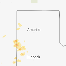


Cities Most Affected by Hail Storms of 4/29/2018
| Hail Size | Demographics of Zip Codes Affected | ||||||
|---|---|---|---|---|---|---|---|
| City | Count | Average | Largest | Pop Density | House Value | Income | Age |
| Clovis, NM | 2 | 1.88 | 2.00 | 93 | $66k | $28.9k | 31.3 |
| Goodland, KS | 1 | 2.00 | 2.00 | 9 | $65k | $33.1k | 41.5 |
| Alpine, TX | 1 | 1.75 | 1.75 | 3 | $68k | $25.8k | 39.8 |
| Marathon, TX | 1 | 1.75 | 1.75 | 0 | $58k | $23.0k | 51.5 |
Hail and Wind Damage Spotted on 4/29/2018
Filter by Report Type:Hail ReportsWind Reports
New Mexico
| Local Time | Report Details |
|---|---|
| 3:26 PM MDT | Quarter sized hail reported near Clovis, NM, 60.8 miles SSE of Tucumcari, NM |
| 3:30 PM MDT | Quarter sized hail reported near Clovis, NM, 60.8 miles SSE of Tucumcari, NM |
| 3:45 PM MDT | Ping Pong Ball sized hail reported near Clovis, NM, 59 miles SSE of Tucumcari, NM |
| 4:01 PM MDT | Half Dollar sized hail reported near Clovis, NM, 60.8 miles SSE of Tucumcari, NM |
| 4:06 PM MDT | Quarter sized hail reported near Clovis, NM, 60.8 miles SSE of Tucumcari, NM |
| 4:11 PM MDT | Half Dollar sized hail reported near Clovis, NM, 60.8 miles SSE of Tucumcari, NM |
| 4:11 PM MDT | Hen Egg sized hail reported near Clovis, NM, 59 miles SSE of Tucumcari, NM, llano estacado and norris |
| 4:15 PM MDT | Storm damage reported in quay county NM, 0.3 miles ENE of Tucumcari, NM |
| 4:21 PM MDT | Ktcc aso in quay county NM, 6.9 miles ENE of Tucumcari, NM |
| 4:25 PM MDT | Golf Ball sized hail reported near Clovis, NM, 60.2 miles SSE of Tucumcari, NM, skylights broken near vivian and cain |
Texas
| Local Time | Report Details |
|---|---|
| 5:55 PM CDT | Quarter sized hail reported near Farwell, TX, 61.5 miles SE of Tucumcari, NM, grass fires started on cnty rd 8 ne of farwell & cnty rd b near rhea |
| 6:05 PM CDT | Golf Ball sized hail reported near Marathon, TX, 27.4 miles ESE of Alpine, TX |
| 6:55 PM CDT | Quarter sized hail reported near Marathon, TX, 27.4 miles ESE of Alpine, TX, at the gage hotel in marathon |
| 7:35 PM CDT | Ping Pong Ball sized hail reported near Alpine, TX, 1.2 miles NE of Alpine, TX |
| 7:45 PM CDT | Quarter sized hail reported near Muleshoe, TX, 66.7 miles NW of Lubbock, TX |
| 7:45 PM CDT | Golf Ball sized hail reported near Alpine, TX, 2.3 miles NNE of Alpine, TX |
| 8:50 PM CDT | Storm damage reported in castro county TX, 51 miles SSW of Amarillo, TX |
South Dakota
| Local Time | Report Details |
|---|---|
| 5:00 PM MDT | Quarter sized hail reported near Custer, SD, 37.1 miles SSW of Rapid City, SD |
Kansas
| Local Time | Report Details |
|---|---|
| 5:00 PM MDT | Half Dollar sized hail reported near Goodland, KS, 35.2 miles W of Colby, KS |
| 5:01 PM MDT | Ping Pong Ball sized hail reported near Goodland, KS, 36.3 miles W of Colby, KS, hail size ranges from dimes to ping pong ball size. |
| 5:01 PM MDT | Hen Egg sized hail reported near Goodland, KS, 36.2 miles W of Colby, KS, hail fell ranging from quarters to 1.5 inches with a few hailstones up to 2 inches. |
| 5:02 PM MDT | Quarter sized hail reported near Goodland, KS, 35.2 miles W of Colby, KS |
| 5:06 PM MDT | Ping Pong Ball sized hail reported near Goodland, KS, 35.1 miles W of Colby, KS, soft disc shaped hail stones measured at 1.5 inches in length and less than one quarter inch thick. |
| 7:55 PM CDT | Quarter sized hail reported near Ulysses, KS, 42 miles SW of Garden City, KS, nickel to quarter size hail. |
| 8:17 PM CDT | Ping Pong Ball sized hail reported near Ulysses, KS, 39.2 miles WSW of Garden City, KS, photo from social media with a quarter to compare size. |
| 8:22 PM CDT | Quarter sized hail reported near Ulysses, KS, 33.9 miles WSW of Garden City, KS, several quarter inch hail stones. |
| 8:44 PM MDT | Storm damage reported in greeley county KS, 62 miles NW of Garden City, KS |
Montana
| Local Time | Report Details |
|---|---|
| 6:17 PM MDT | 76 mph recorded on a home weather statio in prairie county MT, 47.5 miles ENE of Miles City, MT |
| 7:00 PM MDT | Glendive airport awos reported a peak wind of 60 mph at 0100z or 700 p in dawson county MT, 70.5 miles NE of Miles City, MT |
Wyoming
| Local Time | Report Details |
|---|---|
| 7:02 PM MDT | A shed was tossed into a pasture near cr 80 and van tassell rd north of torrington. a wall was blown in at a shop in the 3700 block of buttermilk rd. peak wind gust at in goshen county WY, 35.9 miles WNW of Scottsbluff, NE |
Connect with Interactive Hail Maps