

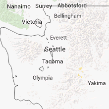
Hail Map for Saturday, August 2, 2014

Number of Impacted Households on 8/2/2014
0
Impacted by 1" or Larger Hail
0
Impacted by 1.75" or Larger Hail
0
Impacted by 2.5" or Larger Hail
Square Miles of Populated Area Impacted on 8/2/2014
0
Impacted by 1" or Larger Hail
0
Impacted by 1.75" or Larger Hail
0
Impacted by 2.5" or Larger Hail


Cities Most Affected by Hail Storms of 8/2/2014
| Hail Size | Demographics of Zip Codes Affected | ||||||
|---|---|---|---|---|---|---|---|
| City | Count | Average | Largest | Pop Density | House Value | Income | Age |
| Platte, SD | 3 | 1.83 | 2.00 | 3 | $60k | $30.6k | 45.1 |
| Stickney, SD | 2 | 1.75 | 1.75 | 3 | $28k | $28.9k | 47.9 |
| Butte, NE | 2 | 1.75 | 1.75 | 3 | $24k | $25.0k | 47.5 |
| Geddes, SD | 1 | 2.00 | 2.00 | 3 | $23k | $24.1k | 45.2 |
Hail and Wind Damage Spotted on 8/2/2014
Filter by Report Type:Hail ReportsWind Reports
States Impacted
Ohio, Tennessee, Kentucky, New York, West Virginia, Nebraska, Nevada, Washington, Michigan, Oregon, South Dakota, Idaho, MontanaOhio
| Local Time | Report Details |
|---|---|
| 1:59 PM EDT | Quarter sized hail reported near Chillicothe, OH, 45.7 miles S of Columbus, OH |
| 4:16 PM EDT | Trees down along route 243 in lawrence county OH, 41.8 miles W of Charleston, WV |
| 4:29 PM EDT | Quarter sized hail reported near Proctorville, OH, 40.7 miles W of Charleston, WV, quarter size hail observed. small branches blown down |
Tennessee
| Local Time | Report Details |
|---|---|
| 2:15 PM EDT | Few trees dow in hamilton county TN, 6 miles NNW of Chattanooga, TN |
Kentucky
| Local Time | Report Details |
|---|---|
| 2:15 PM EDT | Quarter sized hail reported near Berea, KY, 22.6 miles WSW of Irvine, KY |
| 5:35 PM EDT | Quarter sized hail reported near Georgetown, KY, 52.5 miles NW of Irvine, KY, quarter size hail on duvall station road |
New York
| Local Time | Report Details |
|---|---|
| 3:06 PM EDT | Quarter sized hail reported near Brushton, NY, 49.1 miles ENE of Ogdensburg, NY, quarter sized hail |
| 4:51 PM EDT | Tree and wires down in cattaraugus county NY, 34 miles SE of Buffalo, NY |
| 5:15 PM EDT | Ping Pong Ball sized hail reported near Jamestown, NY, 58.9 miles SSW of Buffalo, NY |
| 5:15 PM EDT | Trees dow in chautauqua county NY, 58.9 miles SSW of Buffalo, NY |
| 6:30 PM EDT | Storm with strong gusts. small branches dow in steuben county NY, 72.3 miles ESE of Buffalo, NY |
| 6:35 PM EDT | 3 power poles and lines down due to downing of 36 inch diameter tree. radar est tim in cayuga county NY, 25.3 miles SW of Syracuse, NY |
| 7:14 PM EDT | Quarter sized hail reported near Lodi, NY, 45.7 miles SW of Syracuse, NY |
| 7:48 PM EDT | Quarter sized hail reported near Rome, NY, 35.5 miles ENE of Syracuse, NY, also strong gusty winds and heavy rain. |
| 8:51 PM EDT | Tree and wires down in cattaraugus county NY, 34 miles SE of Buffalo, NY |
West Virginia
| Local Time | Report Details |
|---|---|
| 4:18 PM EDT | Trees down on 9th ave...power lines down on 8th ave in cabell county WV, 43.1 miles W of Charleston, WV |
| 4:20 PM EDT | Large tree limb fell on truck near 9th ave and 24th st in cabell county WV, 43.1 miles W of Charleston, WV |
| 4:34 PM EDT | Several trees about 1 foot in diameter down along i-64 near mile marker 20 in putnam county WV, 16.7 miles WNW of Charleston, WV |
| 4:35 PM EDT | Power lines and trees down along mccomas and martha roads in barboursville in cabell county WV, 35.5 miles W of Charleston, WV |
| 4:35 PM EDT | Trees down along howells mill road in cabell county WV, 31.4 miles W of Charleston, WV |
| 4:52 PM EDT | Tree limbs down in mason county WV, 26.6 miles WNW of Charleston, WV |
| 5:03 PM EDT | Several tree limbs 2 to 3 inches in diameter down in putnam county WV, 16.7 miles WNW of Charleston, WV |
| 5:30 PM EDT | Tree down onto power lines -- time based on radar in kanawha county WV, 13.8 miles NNW of Charleston, WV |
| 5:43 PM EDT | Tree down along maccorkle ave se -- time estimated from radar in kanawha county WV, 3.8 miles ESE of Charleston, WV |
| 5:50 PM EDT | Trees and power lines down in the roadway along shamrock road in kanawha county WV, 0.5 miles E of Charleston, WV |
| 6:09 PM EDT | 7080 customers without power in cabell county in cabell county WV, 43.1 miles W of Charleston, WV |
Nebraska
| Local Time | Report Details |
|---|---|
| 4:50 PM CDT | Quarter sized hail reported near Sargent, NE, 72.1 miles ENE of North Platte, NE |
| 5:40 PM CDT | Quarter sized hail reported near Arcadia, NE, 46.7 miles NW of Grand Island, NE, heavy rain... lot of crop damage |
| 5:53 PM CDT | Quarter sized hail reported near North Loup, NE, 40.3 miles NNW of Grand Island, NE, hail up to quarter size in the far southeast corner of valley county. |
| 5:54 PM CDT | Quarter sized hail reported near Ashton, NE, 37.5 miles NW of Grand Island, NE |
| 6:04 PM CDT | Quarter sized hail reported near Elba, NE, 34.6 miles NNW of Grand Island, NE |
| 9:13 PM CDT | Quarter sized hail reported near Spencer, NE, 35.3 miles N of Oneill, NE |
| 9:30 PM CDT | Golf Ball sized hail reported near Butte, NE, 33.7 miles NNW of Oneill, NE |
| 9:33 PM CDT | Golf Ball sized hail reported near Butte, NE, 32.9 miles NNW of Oneill, NE |
| 9:45 PM CDT | Quarter sized hail reported near Atkinson, NE, 24.3 miles NW of Oneill, NE |
Nevada
| Local Time | Report Details |
|---|---|
| 3:41 PM PDT | Rock spring creek raws. elevation 5427 ft amsl in elko county NV, 63.3 miles S of Twin Falls, ID |
Washington
| Local Time | Report Details |
|---|---|
| 4:02 PM PDT | Estimated winds between 50 and 60 mph. heard of trees down at two rivers marin in lincoln county WA, 45.4 miles WNW of Spokane, WA |
| 5:02 PM PDT | Trees and power outages reported around nespele in okanogan county WA, 30.6 miles ESE of Omak, WA |
| 5:06 PM PDT | Spotter in deer park relayed that several fires were reported across northern spokane county. riverside mobile home park was being evacuated because of falling tree in spokane county WA, 20.9 miles N of Spokane, WA |
| 5:39 PM PDT | Midnight mine raws measured 68 mph wind gust with thunderstorm outflow boundar in stevens county WA, 34.6 miles WNW of Spokane, WA |
| 6:00 PM PDT | Thunderstorm winds caused a portion of a tree to fall on a hom in spokane county WA, 2.5 miles WSW of Spokane, WA |
| 6:00 PM PDT | Trees down blocking us 2 north of mt spokane day road and near deer park-milan roa in spokane county WA, 10.3 miles NNE of Spokane, WA |
| 6:00 PM PDT | Tree down on house on e. decatur av in spokane county WA, 3.9 miles NNE of Spokane, WA |
| 6:00 PM PDT | Tree down at 17th and mt. vernon in spokane county WA, 2.3 miles ESE of Spokane, WA |
| 6:00 PM PDT | Trees down blocking sr 211 in pend oreille county WA, 31.2 miles NNE of Spokane, WA |
| 6:00 PM PDT | Power pole snapped in spokane county WA, 7.4 miles NNW of Spokane, WA |
| 6:00 PM PDT | Quarter sized hail reported near Spokane, WA, 5.5 miles NNW of Spokane, WA, 5 mile prairie |
| 6:00 PM PDT | Ping Pong Ball sized hail reported near Spokane, WA, 6 miles NNW of Spokane, WA, 5 mile prairie via twitter |
| 6:02 PM PDT | 12 to 15 inch diameter tree knocked down at sundance golf course from thunderstorm gust fron in spokane county WA, 6.8 miles NW of Spokane, WA |
| 6:05 PM PDT | 4 trees reported down at hill n dale apartments at magnesium st. 1 tree landed on a vehicle leading to car damag in spokane county WA, 2.3 miles N of Spokane, WA |
| 6:10 PM PDT | 40 foot tree uprooted over driveway on north grove r in spokane county WA, 27.4 miles N of Spokane, WA |
| 6:13 PM PDT | Tree down at rowan and nevada in spokane county WA, 3.8 miles NNE of Spokane, WA |
| 6:30 PM PDT | Large tree uprooted and fell on hom in spokane county WA, 20.9 miles N of Spokane, WA |
Michigan
| Local Time | Report Details |
|---|---|
| 7:48 PM EDT | Quarter sized hail reported near Detroit, MI, 47.9 miles SE of Flint, MI, on woodingham drive between outer drive and st. martins |
Oregon
| Local Time | Report Details |
|---|---|
| 5:10 PM PDT | Half Dollar sized hail reported near Warm Springs, OR, 39.1 miles NW of Bend, OR |
| 5:10 PM PDT | Half Dollar sized hail reported near , , 60.5 miles SE of Portland, OR |
| 5:32 PM PDT | Quarter sized hail reported near Bend, OR, 28.2 miles SW of Bend, OR |
| 5:38 PM PDT | Quarter sized hail reported near Bend, OR, 28.2 miles WSW of Bend, OR |
| 5:40 PM PDT | Half Dollar sized hail reported near Bend, OR, 28.2 miles SW of Bend, OR, hail larger than a quarter. |
| 7:21 PM PDT | Quarter sized hail reported near Bend, OR, 29.1 miles SW of Bend, OR |
South Dakota
| Local Time | Report Details |
|---|---|
| 7:36 PM CDT | Half Dollar sized hail reported near Stickney, SD, 78.9 miles N of Oneill, NE, mostly dime size hail with a few half dollar size...smaller hail falling 10 minutes later. |
| 7:47 PM CDT | Golf Ball sized hail reported near Stickney, SD, 78.9 miles N of Oneill, NE |
| 7:54 PM CDT | Hen Egg sized hail reported near Platte, SD, 63.8 miles N of Oneill, NE |
| 8:10 PM CDT | Golf Ball sized hail reported near Stickney, SD, 75.1 miles N of Oneill, NE |
| 8:10 PM CDT | Hen Egg sized hail reported near Geddes, SD, 54.8 miles N of Oneill, NE, some broken windows were noted |
| 8:51 PM CDT | Half Dollar sized hail reported near Kimball, SD, 81.7 miles N of Oneill, NE |
| 9:15 PM CDT | Golf Ball sized hail reported near Platte, SD, 73.4 miles NNW of Oneill, NE, ground covered in hail ranging from marble to golf ball in size |
| 9:30 PM CDT | Golf Ball sized hail reported near Platte, SD, 66.9 miles NNW of Oneill, NE, hail up to golf ball in size covered ground |
Idaho
| Local Time | Report Details |
|---|---|
| 8:04 PM PDT | Trees limbs down across the community of cataldo from thunderstorm wind in shoshone county ID, 51.7 miles E of Spokane, WA |
| 8:40 PM PDT | Multiple large trees down... power is out with multiple lines down... some structures sustained damage... streets still blocked by debris. winds estimated to 60 mp in bonner county ID, 58.4 miles NE of Spokane, WA |
Montana
| Local Time | Report Details |
|---|---|
| 9:20 PM MDT | Numerous trees and power lines down in lincoln county MT, 71.5 miles W of Whitefish, MT |
| 9:45 PM MDT | Report of a tree down blocking the south bound lanes of highway 56 between mile marker 23 and 2 in lincoln county MT, 69.7 miles W of Whitefish, MT |
| 9:50 PM MDT | Reports of numerous downed trees and power lines. roads are blocke in lincoln county MT, 56.3 miles W of Whitefish, MT |
Connect with Interactive Hail Maps