

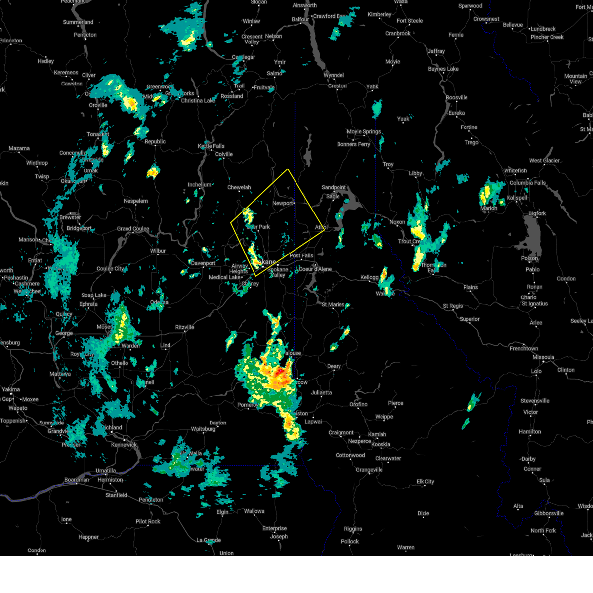
Hail Map for Spokane, WA
The Spokane, WA area has had 3 reports of on-the-ground hail by trained spotters, and has been under severe weather warnings 1 time during the past 12 months. Doppler radar has detected hail at or near Spokane, WA on 5 occasions.
| Name: | Spokane, WA |
| Where Located: | 1.2 miles NNE of Spokane, WA |
| Map: | Google Map for Spokane, WA |
| Population: | 208916 |
| Housing Units: | 94291 |
| More Info: | Search Google for Spokane, WA |
5
The Top Recent Hail Date for Spokane, WA is Friday, July 22, 2016 (1st out of 5)

Hail and Wind Damage Spotted near Spokane, WA
| Date / Time | Report Details |
|---|---|
| 9/26/2024 4:30 PM PDT | Several trees blown down on whitworth universit in spokane county WA, 5.3 miles S of Spokane, WA |
| 9/25/2024 6:02 PM PDT | 12...394 power outages in spokane county from storm in spokane county WA, 1.6 miles N of Spokane, WA |
| 9/25/2024 5:00 PM PDT | Several large tree branches broken off tops of trees. some fell on tops of the roof and broke through. significant roof damage. also reported blowing debris and dus in spokane county WA, 2.8 miles SSE of Spokane, WA |
| 9/25/2024 5:00 PM PDT | Time estimated based on radar. spotter shared picture of large tree snapped near the top that fell on nearby hom in spokane county WA, 12 miles ESE of Spokane, WA |
| 9/25/2024 4:40 PM PDT | Image shared on social media shows a large tree uprooted at garry middle schoo in spokane county WA, 2.5 miles S of Spokane, WA |
| 9/25/2024 4:30 PM PDT | Downed power line started a fire in the are in spokane county WA, 4.1 miles NNW of Spokane, WA |
| 9/25/2024 4:30 PM PDT | Numerous power lines down near intersection of little spokane and wandermere in north spokan in spokane county WA, 8.1 miles S of Spokane, WA |
| 9/25/2024 4:26 PM PDT | Report from mping: trees uprooted or snapped; roof blown of in spokane county WA, 2.8 miles SSE of Spokane, WA |
| 9/25/2024 4:23 PM PDT |
 Svrotx the national weather service in spokane has issued a * severe thunderstorm warning for, southwestern bonner county in the panhandle of idaho, northwestern kootenai county in the panhandle of idaho, southeastern stevens county in northeastern washington, northern spokane county in northeastern washington, southeastern pend oreille county in northeastern washington, * until 530 pm pdt. * at 423 pm pdt, a severe thunderstorm was located over nine mile falls, or 8 miles northwest of spokane, moving northeast at 40 mph (radar indicated). Hazards include 60 mph wind gusts. expect damage to roofs, siding, and trees Svrotx the national weather service in spokane has issued a * severe thunderstorm warning for, southwestern bonner county in the panhandle of idaho, northwestern kootenai county in the panhandle of idaho, southeastern stevens county in northeastern washington, northern spokane county in northeastern washington, southeastern pend oreille county in northeastern washington, * until 530 pm pdt. * at 423 pm pdt, a severe thunderstorm was located over nine mile falls, or 8 miles northwest of spokane, moving northeast at 40 mph (radar indicated). Hazards include 60 mph wind gusts. expect damage to roofs, siding, and trees
|
| 8/27/2024 3:57 PM PDT | Report from mping: 1-inch tree limbs broken; shingles blown of in spokane county WA, 12 miles ESE of Spokane, WA |
| 6/30/2024 8:30 PM PDT | Tree branch down on powerlines. over 700 people without powe in spokane county WA, 5.3 miles S of Spokane, WA |
| 6/30/2024 3:40 PM PDT | Tree down on powerline. handful of power outages in regio in spokane county WA, 5.3 miles WSW of Spokane, WA |
| 5/29/2024 4:50 PM PDT | 6 inch diameter branches dow in spokane county WA, 2.3 miles ENE of Spokane, WA |
| 6/8/2023 4:57 PM PDT |
 The severe thunderstorm warning for northwestern benewah, southwestern kootenai and eastern spokane counties will expire at 500 pm pdt, the storms which prompted the warning have moved out of the area. therefore, the warning will be allowed to expire. however, gusty winds are still possible with these thunderstorms. The severe thunderstorm warning for northwestern benewah, southwestern kootenai and eastern spokane counties will expire at 500 pm pdt, the storms which prompted the warning have moved out of the area. therefore, the warning will be allowed to expire. however, gusty winds are still possible with these thunderstorms.
|
| 6/8/2023 4:52 PM PDT | Off duty nws employee reports multiple pine trees 4-8 inch diameter dow in spokane county WA, 5 miles ENE of Spokane, WA |
| 6/8/2023 4:48 PM PDT | Uprooted tree estimated to be 18 inches in diameter. time estimated from rada in spokane county WA, 3.1 miles NE of Spokane, WA |
| 6/8/2023 4:47 PM PDT | Corrects previous tstm wnd dmg report from 1 s dishman. off duty nws employee reports 6 inch tree down. time estimated based on rada in spokane county WA, 6.8 miles WNW of Spokane, WA |
| 6/8/2023 4:47 PM PDT | Corrects previous tstm wnd dmg report from 1 s dishman. off duty nws employee reports 6 inch tree down. time estimated based on rada in spokane county WA, 6.8 miles WNW of Spokane, WA |
| 6/8/2023 4:44 PM PDT | Off-duty nws meteorologist reports trees down or snapped near downriver drive. time estimated from rada in spokane county WA, 2.6 miles E of Spokane, WA |
| 6/8/2023 4:39 PM PDT | Social media reports of damage to siding and fencing to a property on the north side of spokane. time estimated from rada in spokane county WA, 3.9 miles S of Spokane, WA |
| 6/8/2023 4:35 PM PDT | A few public reports of trees and limbs down in spokane valley. time estimated from rada in spokane county WA, 7.3 miles W of Spokane, WA |
| 6/8/2023 4:34 PM PDT |
 At 433 pm pdt, severe thunderstorms were located along a line extending from near chattaroy to 9 miles west of plummer, moving west at 15 mph (trained weather spotters reported damage in greenacres at 426 pm). Hazards include 60 mph wind gusts and nickel size hail. Expect damage to roofs, siding, and trees. locations impacted include, spokane, spokane valley, post falls, liberty lake, nine mile falls, millwood, plummer, hauser, otis orchards-east farms, fairwood, otis orchards, green acres, trentwood, country homes, town and country, chattaroy, dishman, mead, fairfield, and rockford. this includes the following highways, interstate 90 in washington between mile markers 277 and 299. interstate 90 in idaho between mile markers 0 and 5. u. s. highway 95 in idaho between mile markers 391 and 420. u. s. highway 2 in washington between mile markers 282 and 305. u. s. highway 195 in washington between mile markers 75 and 95. u. s. highway 395 in washington between mile markers 165 and 177. hail threat, radar indicated max hail size, 0. 88 in wind threat, radar indicated max wind gust, 60 mph. At 433 pm pdt, severe thunderstorms were located along a line extending from near chattaroy to 9 miles west of plummer, moving west at 15 mph (trained weather spotters reported damage in greenacres at 426 pm). Hazards include 60 mph wind gusts and nickel size hail. Expect damage to roofs, siding, and trees. locations impacted include, spokane, spokane valley, post falls, liberty lake, nine mile falls, millwood, plummer, hauser, otis orchards-east farms, fairwood, otis orchards, green acres, trentwood, country homes, town and country, chattaroy, dishman, mead, fairfield, and rockford. this includes the following highways, interstate 90 in washington between mile markers 277 and 299. interstate 90 in idaho between mile markers 0 and 5. u. s. highway 95 in idaho between mile markers 391 and 420. u. s. highway 2 in washington between mile markers 282 and 305. u. s. highway 195 in washington between mile markers 75 and 95. u. s. highway 395 in washington between mile markers 165 and 177. hail threat, radar indicated max hail size, 0. 88 in wind threat, radar indicated max wind gust, 60 mph.
|
| 6/8/2023 4:31 PM PDT | Blown over trash cans... trees swaying... road gutter 50 0.000000ull of running w in spokane county WA, 2 miles SW of Spokane, WA |
| 6/8/2023 4:27 PM PDT | Downed tree limbs near mission avenue and pines road. social media report. time estimated from rada in spokane county WA, 7.7 miles W of Spokane, WA |
| 6/8/2023 4:25 PM PDT |
 At 423 pm pdt, severe thunderstorms were located along a line extending from 6 miles east of chattaroy to 7 miles west of plummer, moving west at 20 mph (trained weather spotters reported downed tree limbs and highway signs near lake coeur d`alene earlier with these storms). Hazards include 60 mph wind gusts and nickel size hail. Expect damage to roofs, siding, and trees. locations impacted include, spokane, spokane valley, post falls, rathdrum, liberty lake, nine mile falls, millwood, plummer, hauser, harrison, otis orchards-east farms, fairwood, otis orchards, green acres, trentwood, country homes, town and country, chattaroy, dishman, and mead. this includes the following highways, interstate 90 in washington between mile markers 277 and 299. interstate 90 in idaho between mile markers 0 and 8. u. s. highway 95 in idaho between mile markers 390 and 425. u. s. highway 2 in washington between mile markers 282 and 305. u. s. highway 195 in washington between mile markers 75 and 95. u. s. highway 395 in washington between mile markers 165 and 177. hail threat, radar indicated max hail size, 0. 88 in wind threat, radar indicated max wind gust, 60 mph. At 423 pm pdt, severe thunderstorms were located along a line extending from 6 miles east of chattaroy to 7 miles west of plummer, moving west at 20 mph (trained weather spotters reported downed tree limbs and highway signs near lake coeur d`alene earlier with these storms). Hazards include 60 mph wind gusts and nickel size hail. Expect damage to roofs, siding, and trees. locations impacted include, spokane, spokane valley, post falls, rathdrum, liberty lake, nine mile falls, millwood, plummer, hauser, harrison, otis orchards-east farms, fairwood, otis orchards, green acres, trentwood, country homes, town and country, chattaroy, dishman, and mead. this includes the following highways, interstate 90 in washington between mile markers 277 and 299. interstate 90 in idaho between mile markers 0 and 8. u. s. highway 95 in idaho between mile markers 390 and 425. u. s. highway 2 in washington between mile markers 282 and 305. u. s. highway 195 in washington between mile markers 75 and 95. u. s. highway 395 in washington between mile markers 165 and 177. hail threat, radar indicated max hail size, 0. 88 in wind threat, radar indicated max wind gust, 60 mph.
|
| 6/8/2023 4:10 PM PDT |
 At 409 pm pdt, severe thunderstorms were located along a line extending from near hauser to 6 miles west of harrison, moving west at 15 mph (radar indicated). Hazards include 60 mph wind gusts and nickel size hail. expect damage to roofs, siding, and trees At 409 pm pdt, severe thunderstorms were located along a line extending from near hauser to 6 miles west of harrison, moving west at 15 mph (radar indicated). Hazards include 60 mph wind gusts and nickel size hail. expect damage to roofs, siding, and trees
|
| 11/5/2022 1:54 AM PDT | Sr 27 (pines) sb near mansfield is also blocked by a tre in spokane county WA, 7.8 miles W of Spokane, WA |
| 11/5/2022 1:07 AM PDT | Report of power lines down via social medi in spokane county WA, 8.1 miles WNW of Spokane, WA |
| 8/12/2022 8:57 AM PDT |
 The severe thunderstorm warning for southeastern spokane county will expire at 900 am pdt, the storm which prompted the warning has weakened below severe limits, and no longer poses an immediate threat to life or property. therefore, the warning will be allowed to expire. however small hail is still possible with this thunderstorm. The severe thunderstorm warning for southeastern spokane county will expire at 900 am pdt, the storm which prompted the warning has weakened below severe limits, and no longer poses an immediate threat to life or property. therefore, the warning will be allowed to expire. however small hail is still possible with this thunderstorm.
|
| 8/12/2022 8:49 AM PDT |
 At 849 am pdt, a severe thunderstorm was located 13 miles south of dishman, or 13 miles south of spokane valley, moving northeast at 30 mph (radar indicated). Hazards include half dollar size hail. Damage to vehicles is expected. locations impacted include, spangle, mica and valleyford. hail threat, radar indicated max hail size, 1. 25 in wind threat, radar indicated max wind gust, <50 mph. At 849 am pdt, a severe thunderstorm was located 13 miles south of dishman, or 13 miles south of spokane valley, moving northeast at 30 mph (radar indicated). Hazards include half dollar size hail. Damage to vehicles is expected. locations impacted include, spangle, mica and valleyford. hail threat, radar indicated max hail size, 1. 25 in wind threat, radar indicated max wind gust, <50 mph.
|
| 8/12/2022 8:29 AM PDT |
 At 829 am pdt, a severe thunderstorm was located 14 miles southeast of cheney, moving northeast at 30 mph (radar indicated). Hazards include half dollar size hail. damage to vehicles is expected At 829 am pdt, a severe thunderstorm was located 14 miles southeast of cheney, moving northeast at 30 mph (radar indicated). Hazards include half dollar size hail. damage to vehicles is expected
|
| 5/6/2022 7:34 PM PDT | Trees down on a home. via social medi in spokane county WA, 4.8 miles WNW of Spokane, WA |
| 5/6/2022 7:23 PM PDT | Tree limb on a ca in spokane county WA, 3.5 miles WNW of Spokane, WA |
| 5/6/2022 7:20 PM PDT | Damage to a mobile home par in spokane county WA, 3.7 miles WNW of Spokane, WA |
| 5/6/2022 7:12 PM PDT | Downed tree and wires from thunderstorm winds near geiger boulevard. time estimated from rada in spokane county WA, 6.1 miles NE of Spokane, WA |
| 5/6/2022 7:12 PM PDT | Downed tree and wires from thunderstorm winds near soda road. time estimated from rada in spokane county WA, 7.3 miles NE of Spokane, WA |
| 5/6/2022 7:03 PM PDT | Downed tree and wires near mission road. time estimated from rada in spokane county WA, 5.8 miles E of Spokane, WA |
| 4/4/2022 2:27 PM PDT | Report from mping: 1-inch tree limbs broken; shingles blown of in spokane county WA, 10 miles SSE of Spokane, WA |
| 5/30/2020 8:01 PM PDT | Measured by geg aso in spokane county WA, 6.5 miles NE of Spokane, WA |
| 5/30/2020 7:29 PM PDT | Corrects previous tstm wnd gst report from 5 n airway height in spokane county WA, 8.7 miles ESE of Spokane, WA |
| 5/30/2020 7:25 PM PDT |
 At 723 pm pdt, severe thunderstorms were located along a line extending from 31 miles north of ritzville to near davenport to near medical lake to near fairchild afb, moving northeast at 50 mph (radar indicated). Hazards include 60 mph wind gusts and quarter size hail. expect wind damage to roofs, siding, and trees At 723 pm pdt, severe thunderstorms were located along a line extending from 31 miles north of ritzville to near davenport to near medical lake to near fairchild afb, moving northeast at 50 mph (radar indicated). Hazards include 60 mph wind gusts and quarter size hail. expect wind damage to roofs, siding, and trees
|
| 5/30/2020 7:09 PM PDT |
 At 706 pm pdt, severe thunderstorms were located along a line extending from 23 miles north of ritzville to 14 miles southeast of davenport to 7 miles south of medical lake to 14 miles southeast of cheney, moving northeast at 50 mph (radar indicated). Hazards include 70 mph wind gusts and quarter size hail. Expect considerable tree damage. wind damage is also likely to mobile homes, roofs, and outbuildings. Locations impacted include, spokane, cheney, airway heights, medical lake, davenport, fairchild afb, odessa, reardan, harrington, spangle, mohler, amber, gravelles, tyler, mondovi, lamona, rocklyn, valleyford, eleanor and bluestem. At 706 pm pdt, severe thunderstorms were located along a line extending from 23 miles north of ritzville to 14 miles southeast of davenport to 7 miles south of medical lake to 14 miles southeast of cheney, moving northeast at 50 mph (radar indicated). Hazards include 70 mph wind gusts and quarter size hail. Expect considerable tree damage. wind damage is also likely to mobile homes, roofs, and outbuildings. Locations impacted include, spokane, cheney, airway heights, medical lake, davenport, fairchild afb, odessa, reardan, harrington, spangle, mohler, amber, gravelles, tyler, mondovi, lamona, rocklyn, valleyford, eleanor and bluestem.
|
| 5/30/2020 6:53 PM PDT |
 At 652 pm pdt, severe thunderstorms were located along a line extending from 11 miles northeast of ritzville to 24 miles southwest of medical lake to 16 miles southwest of cheney to 20 miles north of colfax, moving northeast at 50 mph (radar indicated). Hazards include 70 mph wind gusts and quarter size hail. Hail damage to vehicles is expected. expect considerable tree damage. Wind damage is also likely to mobile homes, roofs, and outbuildings. At 652 pm pdt, severe thunderstorms were located along a line extending from 11 miles northeast of ritzville to 24 miles southwest of medical lake to 16 miles southwest of cheney to 20 miles north of colfax, moving northeast at 50 mph (radar indicated). Hazards include 70 mph wind gusts and quarter size hail. Hail damage to vehicles is expected. expect considerable tree damage. Wind damage is also likely to mobile homes, roofs, and outbuildings.
|
| 3/30/2020 11:33 AM PDT | Report via social media of tree downed on house on indian trail road in north spokane. exact location unknown. time estimated by rada in spokane county WA, 5.2 miles SE of Spokane, WA |
| 7/23/2019 10:10 PM PDT | Tree downed and damaged vehicle in spokane county WA, 3.8 miles N of Spokane, WA |
| 7/23/2019 9:55 PM PDT | Tree downed by wind and lightnin in spokane county WA, 2.3 miles NE of Spokane, WA |
| 7/23/2019 9:23 PM PDT |
 At 857 pm pdt, severe thunderstorms were located along a line extending from 10 miles northwest of fairchild afb to 7 miles south of dishman, moving northeast at 50 mph (radar indicated). Hazards include 60 mph wind gusts and penny size hail. expect damage to roofs, siding, and trees At 857 pm pdt, severe thunderstorms were located along a line extending from 10 miles northwest of fairchild afb to 7 miles south of dishman, moving northeast at 50 mph (radar indicated). Hazards include 60 mph wind gusts and penny size hail. expect damage to roofs, siding, and trees
|
| 7/23/2019 9:21 PM PDT | Spokane felts field peak wind gus in spokane county WA, 4.2 miles WSW of Spokane, WA |
| 7/23/2019 8:59 PM PDT | Corrects previous tstm wnd gst report from spokane internationa in spokane county WA, 6.9 miles ENE of Spokane, WA |
| 7/23/2019 8:59 PM PDT | Storm damage reported in spokane county WA, 6.9 miles ENE of Spokane, WA |
| 7/23/2019 8:57 PM PDT |
 At 857 pm pdt, severe thunderstorms were located along a line extending from 10 miles northwest of fairchild afb to 7 miles south of dishman, moving northeast at 50 mph (radar indicated). Hazards include 60 mph wind gusts and penny size hail. expect damage to roofs, siding, and trees At 857 pm pdt, severe thunderstorms were located along a line extending from 10 miles northwest of fairchild afb to 7 miles south of dishman, moving northeast at 50 mph (radar indicated). Hazards include 60 mph wind gusts and penny size hail. expect damage to roofs, siding, and trees
|
| 7/22/2016 4:30 PM PDT | Trees down on powerlines. in spokane county WA, 8.1 miles S of Spokane, WA |
| 7/22/2016 4:07 PM PDT |
 At 402 pm pdt, the public reported a severe thunderstorm producing quarter size hail. hail was reported near downtown spokane and spokane south hill. this storm was located over trentwood, or 10 miles west of post falls, moving east at 20 mph. the storm continued to hold its strenght and redevelop as it moved east. locations impacted include, spokane, post falls, rathdrum, liberty lake, millwood, hauser, green acres, dishman, otis orchards-east farms, trentwood, otis orchards, state line, newman lake, opportunity and veradale. At 402 pm pdt, the public reported a severe thunderstorm producing quarter size hail. hail was reported near downtown spokane and spokane south hill. this storm was located over trentwood, or 10 miles west of post falls, moving east at 20 mph. the storm continued to hold its strenght and redevelop as it moved east. locations impacted include, spokane, post falls, rathdrum, liberty lake, millwood, hauser, green acres, dishman, otis orchards-east farms, trentwood, otis orchards, state line, newman lake, opportunity and veradale.
|
| 7/22/2016 3:54 PM PDT |
 At 352 pm pdt, the public reported a severe thunderstorm with up to one inch hail. this storm was located over spokane, and moving east at 20 mph. At 352 pm pdt, the public reported a severe thunderstorm with up to one inch hail. this storm was located over spokane, and moving east at 20 mph.
|
| 5/4/2016 11:56 PM PDT | Power line down near sharp and atlantic via social media in spokane county WA, 0.3 miles NE of Spokane, WA |
| 5/4/2016 11:13 PM PDT | The severe thunderstorm warning for eastern lincoln and southern spokane counties will expire at 1115 pm pdt, the gust front which prompted the warning has moved out of the area. therefore the warning will be allowed to expire. however heavy rain is still possible with thunderstorms behind this gust front. a severe thunderstorm warning remains in effect for northern spokane county, extreme northern lincoln county and southern stevens and pend orielle counties until 1145 pm. |
| 5/4/2016 11:04 PM PDT |
 At 1104 pm pdt, the public reported a line of severe thunderstorms producing damaging winds in excess of 60 mph. these storms were located along a line extending from 11 miles east of davenport to green acres, and moving north at 40 mph. At 1104 pm pdt, the public reported a line of severe thunderstorms producing damaging winds in excess of 60 mph. these storms were located along a line extending from 11 miles east of davenport to green acres, and moving north at 40 mph.
|
| 5/4/2016 10:26 PM PDT |
 At 1024 pm pdt, doppler radar indicated a strong gust front with a line of severe thunderstorms capable of producing damaging winds in excess of 60 mph. these storms were located along a line extending from 16 miles south of davenport to 13 miles southeast of cheney, and moving north at 35 mph. At 1024 pm pdt, doppler radar indicated a strong gust front with a line of severe thunderstorms capable of producing damaging winds in excess of 60 mph. these storms were located along a line extending from 16 miles south of davenport to 13 miles southeast of cheney, and moving north at 35 mph.
|
| 5/29/2015 9:00 PM PDT | Inland power reports 400 homes witout powe in spokane county WA, 0.3 miles NE of Spokane, WA |
| 5/29/2015 8:35 PM PDT | 1000 without power...avista north-central spokan in spokane county WA, 0.3 miles NE of Spokane, WA |
| 5/29/2015 8:18 PM PDT | Tree branch on power line at 9 mile road and francis producing smoke. branch size unknow in spokane county WA, 0.3 miles NE of Spokane, WA |
| 5/29/2015 8:04 PM PDT | At 755 pm pdt, winds gusted to 53 mph at the national weather service office, just to the west of downtown spokane. winds of this strength can produce damage, and with the recent heavy rains in the area, soft ground could allow for trees to topple. these winds will move east across the interstate 90 corridor as well. locations impacted include, spokane, airway heights, nine mile falls, deer park, millwood, town and country, fairwood, suncrest, chattaroy, mead, dishman, country homes, fairchild afb, trentwood, reardan, opportunity, ford, deep creek, colbert and tum tum. |
| 5/29/2015 7:41 PM PDT | At 737 pm pdt, doppler radar indicated a severe thunderstorm capable of producing damaging winds of around 55 mph. hail to the size of dimes are likely. this storm was located 8 miles west of suncrest, or 18 miles northwest of spokane, and moving east at 25 mph. |
| 8/12/2014 7:30 PM PDT | 2200 s. grand blvd. reported power line down. report by spokane_news in spokane county WA, 3.7 miles N of Spokane, WA |
| 8/12/2014 7:30 PM PDT | N. driscoll and w. wellesley... reported power line down. reported by spokane_news in spokane county WA, 3.1 miles SE of Spokane, WA |
| 8/12/2014 7:30 PM PDT | 547 e. empire... reported power line down. reported by spokane_news in spokane county WA, 1.2 miles SSW of Spokane, WA |
| 8/2/2014 6:13 PM PDT | Tree down at rowan and nevada in spokane county WA, 2.6 miles SSW of Spokane, WA |
| 8/2/2014 6:05 PM PDT | 4 trees reported down at hill n dale apartments at magnesium st. 1 tree landed on a vehicle leading to car damag in spokane county WA, 1.3 miles SSE of Spokane, WA |
| 8/2/2014 6:02 PM PDT | 12 to 15 inch diameter tree knocked down at sundance golf course from thunderstorm gust fron in spokane county WA, 6.2 miles SE of Spokane, WA |
| 8/2/2014 6:00 PM PDT | Quarter sized hail reported 4.6 miles SSE of Spokane, WA, 5 mile prairie |
| 8/2/2014 6:00 PM PDT | Ping Pong Ball sized hail reported 5 miles SSE of Spokane, WA, 5 mile prairie via twitter |
| 8/2/2014 6:00 PM PDT | Thunderstorm winds caused a portion of a tree to fall on a hom in spokane county WA, 3.4 miles NE of Spokane, WA |
| 8/2/2014 6:00 PM PDT | Tree down on house on e. decatur av in spokane county WA, 2.8 miles SSW of Spokane, WA |
| 8/2/2014 6:00 PM PDT | Tree down at 17th and mt. vernon in spokane county WA, 2.9 miles NW of Spokane, WA |
| 8/2/2014 6:00 PM PDT | Power pole snapped in spokane county WA, 6.6 miles SE of Spokane, WA |
| 7/23/2014 5:06 PM PDT | Several large trees uprooted in north spokane near alameda and crown roa in spokane county WA, 3.9 miles SE of Spokane, WA |
| 7/23/2014 5:01 PM PDT | Trees down near riverpark square in downtown spokane in spokane county WA, 0.3 miles NE of Spokane, WA |
| 7/23/2014 5:00 PM PDT | Person injured by falling tree branche in spokane county WA, 1.8 miles ENE of Spokane, WA |
| 7/23/2014 4:28 PM PDT | At least 17 large trees down at sun dance golf course. one downed tree damaged the corner of a home and its dec in spokane county WA, 6.7 miles SE of Spokane, WA |
| 7/23/2014 4:25 PM PDT | Several downed trees at dwight merkel in northwest spokan in spokane county WA, 2 miles SE of Spokane, WA |
| 7/23/2014 4:18 PM PDT | *** 3 inj *** several people injured by falling tree branches near the spokane county courthouse and were taken to the hospita in spokane county WA, 1.8 miles ENE of Spokane, WA |
| 9/15/2013 9:28 PM PDT | Storm damage reported in stevens county WA, 13.1 miles SE of Spokane, WA |
| 9/15/2013 9:28 PM PDT | Tree on power line affecting 391 customers in spokane county WA, 9.1 miles SE of Spokane, WA |
| 9/15/2013 9:25 PM PDT | Trees down and into power lines at bessie/upriver and regal/lincoln in spokane county WA, 0.3 miles NE of Spokane, WA |
| 9/15/2013 9:15 PM PDT | Large tree down at 21st and high driv in spokane county WA, 2.6 miles NNE of Spokane, WA |
| 8/25/2013 8:45 PM PDT | Large tree uproote in spokane county WA, 9.1 miles SE of Spokane, WA |
| 8/25/2013 8:35 PM PDT | Reports of many trees down in the 9 mile falls area...especially along w charles rd. combination of trees being uprooted and snapped. power outages due to trees on powe in spokane county WA, 11.1 miles SE of Spokane, WA |
| 7/20/2012 2:30 PM PDT | Large tree branch fell onto 2 cars near wall and maxwell in spokane county WA, 0.3 miles NE of Spokane, WA |
| 7/20/2012 2:30 PM PDT | Tree fell and knocked out powerline near york and washingto in spokane county WA, 0.3 miles NE of Spokane, WA |
| 7/14/2012 3:15 PM PDT | Quarter sized hail reported 3.7 miles NW of Spokane, WA, dime-sized hail with a few quarter-sized hail. heavy downpours and some water running downhill and ponding near curbside. spotter spokane 1. |
Hail Maps for Spokane, WA


Connect with Interactive Hail Maps