

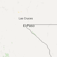
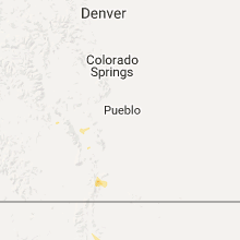
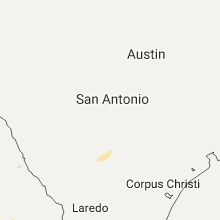
Hail Map for Saturday, August 20, 2016

Number of Impacted Households on 8/20/2016
0
Impacted by 1" or Larger Hail
0
Impacted by 1.75" or Larger Hail
0
Impacted by 2.5" or Larger Hail
Square Miles of Populated Area Impacted on 8/20/2016
0
Impacted by 1" or Larger Hail
0
Impacted by 1.75" or Larger Hail
0
Impacted by 2.5" or Larger Hail


Cities Most Affected by Hail Storms of 8/20/2016
| Hail Size | Demographics of Zip Codes Affected | ||||||
|---|---|---|---|---|---|---|---|
| City | Count | Average | Largest | Pop Density | House Value | Income | Age |
Hail and Wind Damage Spotted on 8/20/2016
Filter by Report Type:Hail ReportsWind Reports
States Impacted
Wisconsin, Michigan, Arizona, Tennessee, West Virginia, Alabama, Indiana, Kentucky, Ohio, Colorado, South CarolinaWisconsin
| Local Time | Report Details |
|---|---|
| 8:11 AM CDT | Measured at racine reef mesonet station in racine county WI, 58.8 miles N of Chicago, IL |
| 10:05 AM CDT | Update of previous report. kewaunee county em reports 20+ trees uprooted or damaged. several roofs with shingle damage. siding off at least 1 home. small trailer flippe in kewaunee county WI, 25.5 miles E of Green Bay, WI |
| 10:05 AM CDT | Trees down. time estimated. delayed repor in kewaunee county WI, 25.6 miles E of Green Bay, WI |
Michigan
| Local Time | Report Details |
|---|---|
| 1:20 PM EDT | An off-duty nws employee estimated wind gusts around 65 mph. no damage was observed in south haven at the time of the call. in van buren county MI, 49.6 miles SW of Grand Rapids, MI |
| 2:16 PM EDT | Spotter estimated wind gust. time estimated by radar. in allegan county MI, 22.3 miles SW of Grand Rapids, MI |
| 2:31 PM EDT | 911 call center relayed a call from the public. extensive wind damage being observed in wyoming. several trees down in the area. possible damage to house. extent of dam in kent county MI, 8.4 miles SSW of Grand Rapids, MI |
| 2:42 PM EDT | Trees down on houses near 32nd st and highgate ave also 2900 blk longstreet ave. possible tornad in kent county MI, 3.9 miles S of Grand Rapids, MI |
| 2:51 PM EDT | Received a call from the public reporting several downed tree limbs. largest limb downed in her yard is 6 inches in diameter. in kent county MI, 3 miles SSE of Grand Rapids, MI |
| 3:55 PM EDT | Crooked pine drive... crooked pine court intersection 1~1.5 dia full pine tree down. one leaning on a house in kent county MI, 5.5 miles SSW of Grand Rapids, MI |
| 4:00 PM EDT | Branch healthy 3~4" da in allegan county MI, 16.5 miles S of Grand Rapids, MI |
| 4:03 PM EDT | .96 inch rain... branches and trees down in the are in kent county MI, 3.6 miles ESE of Grand Rapids, MI |
| 4:24 PM EDT | Trained spotter reports many downed large trees at perkins near leonard blocking road. trees trunks about 3 ft diamete in kent county MI, 2.6 miles NE of Grand Rapids, MI |
| 4:27 PM EDT | Trees down in kent county MI, 5.8 miles SSW of Grand Rapids, MI |
Arizona
| Local Time | Report Details |
|---|---|
| 12:59 PM MST | Quarter sized hail reported near Mormon Lake, AZ, 22.9 miles SSE of Flagstaff, AZ, .75 to 1 inch size hail covered the ground. |
| 1:25 PM MST | Half Dollar sized hail reported near Prescott, AZ, 62.3 miles SW of Flagstaff, AZ |
| 6:30 PM MST | Downed tree reported at a hotel by staff. in maricopa county AZ, 9.4 miles NNW of Phoenix, AZ |
| 8:15 PM MST | Tbra3 gust to 62 mp in mohave county AZ, 46.9 miles ESE of Las Vegas, NV |
Tennessee
| Local Time | Report Details |
|---|---|
| 3:53 PM CDT | A few trees were blown down on harpeth peytonsville road in college grov in williamson county TN, 25.2 miles SSE of Nashville, TN |
| 4:00 PM CDT | A few limbs were blown dow in williamson county TN, 16.8 miles SSW of Nashville, TN |
West Virginia
| Local Time | Report Details |
|---|---|
| 5:28 PM EDT | Tree fell down on a house and also knocked down power line in putnam county WV, 12.4 miles NW of Charleston, WV |
Alabama
| Local Time | Report Details |
|---|---|
| 4:32 PM CDT | Report of tree down near ozark in dale county AL, 78.7 miles S of Auburn, AL |
Indiana
| Local Time | Report Details |
|---|---|
| 5:35 PM EDT | Relayed by trained spotter. report of small trees and limbs down near st. joe and st. joe center roads. time estimated from radar. in allen county IN, 3.8 miles N of Fort Wayne, IN |
| 5:36 PM EDT | Small tree limbs less than six inches in diameter down near evard and maplecrest roads. time estimated from radar. in allen county IN, 4.9 miles NNE of Fort Wayne, IN |
| 5:40 PM EDT | Large tree limb downed. time estimated from radar. in jay county IN, 45 miles S of Fort Wayne, IN |
Kentucky
| Local Time | Report Details |
|---|---|
| 4:53 PM CDT | Several trees down and a barn blown dow in barren county KY, 71.9 miles S of Louisville, KY |
Ohio
| Local Time | Report Details |
|---|---|
| 6:17 PM EDT | Possible tornado at gettysburg-pitsburg road. photos depict large truck overturned and a very large tree uprooted. time estimated based on rada in darke county OH, 66.5 miles N of Cincinnati, OH |
| 6:50 PM EDT | Estimated 2 ft diameter tree uprooted at delaware state park. photo verified. time estimated based on rada in delaware county OH, 29 miles N of Columbus, OH |
| 6:59 PM EDT | Numerous trees down. no structural damage to home in delaware county OH, 27.7 miles N of Columbus, OH |
| 7:20 PM EDT | Shed blown over on grise road. time estimated based on rada in darke county OH, 67.9 miles N of Cincinnati, OH |
Colorado
| Local Time | Report Details |
|---|---|
| 4:25 PM MDT | Quarter sized hail reported near Pagosa Springs, CO, 74.3 miles ENE of Farmington, NM, accompanied by heavy rain. |
| 6:35 PM MDT | Quarter sized hail reported near Westcliffe, CO, 45.9 miles WSW of Pueblo, CO, . |
South Carolina
| Local Time | Report Details |
|---|---|
| 8:41 PM EDT | A tree was blown down across the 4000 block of route 17a. time was estimated from radar dat in berkeley county SC, 17.9 miles ENE of Charleston, SC |
Connect with Interactive Hail Maps