

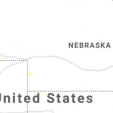
Hail Map for Wednesday, August 21, 2019

Number of Impacted Households on 8/21/2019
0
Impacted by 1" or Larger Hail
0
Impacted by 1.75" or Larger Hail
0
Impacted by 2.5" or Larger Hail
Square Miles of Populated Area Impacted on 8/21/2019
0
Impacted by 1" or Larger Hail
0
Impacted by 1.75" or Larger Hail
0
Impacted by 2.5" or Larger Hail


Cities Most Affected by Hail Storms of 8/21/2019
| Hail Size | Demographics of Zip Codes Affected | ||||||
|---|---|---|---|---|---|---|---|
| City | Count | Average | Largest | Pop Density | House Value | Income | Age |
| Haven, KS | 1 | 2.00 | 2.00 | 17 | $74k | $41.5k | 38.7 |
Hail and Wind Damage Spotted on 8/21/2019
Filter by Report Type:Hail ReportsWind Reports
States Impacted
New York, North Carolina, New Hampshire, Massachusetts, Pennsylvania, Arkansas, Connecticut, Virginia, New Jersey, Rhode Island, Louisiana, Missouri, Oklahoma, Colorado, Wyoming, Maryland, Kansas, Montana, Illinois, Indiana, Kentucky, OhioNew York
| Local Time | Report Details |
|---|---|
| 1:44 PM EDT | Route 111 closed in the town of caroga due to a downed tree in fulton county NY, 36.3 miles NW of Schenectady, NY |
| 2:10 PM EDT | Tree down on route 30 between mayfield and northvill in fulton county NY, 27.3 miles NNW of Schenectady, NY |
| 2:26 PM EDT | Multiple trees down and damage to a bar in fulton county NY, 26.1 miles WNW of Schenectady, NY |
| 3:25 PM EDT | Trees and wires down on mourningkill drive in ballson sp in saratoga county NY, 11.6 miles NNE of Schenectady, NY |
| 3:25 PM EDT | Trees and wires down on west high street in ballston sp in saratoga county NY, 13.6 miles NNE of Schenectady, NY |
| 3:25 PM EDT | Wires down in ballston sp in saratoga county NY, 11.2 miles NNE of Schenectady, NY |
| 3:25 PM EDT | Limbs down on wires in greenfiel in saratoga county NY, 22.4 miles NNE of Schenectady, NY |
| 3:25 PM EDT | Several reports of limbs down on wires in wilto in saratoga county NY, 26.7 miles NNE of Schenectady, NY |
| 3:30 PM EDT | Large tree down. damaged three parked cars on union av in saratoga county NY, 19.8 miles NNE of Schenectady, NY |
| 3:45 PM EDT | Trees and wires down in northumberlan in saratoga county NY, 28.7 miles NNE of Schenectady, NY |
| 3:49 PM EDT | Tree down on route 9 in saratoga county NY, 11.4 miles NE of Schenectady, NY |
| 3:49 PM EDT | Quarter sized hail reported near Round Lake, NY, 11.4 miles NE of Schenectady, NY |
| 3:49 PM EDT | Tree limbs down in yard in accord in ulster county NY, 71.2 miles S of Schenectady, NY |
| 4:07 PM EDT | Tree down on wires at route 32 and creek locks road in ulster county NY, 66.8 miles S of Schenectady, NY |
| 4:10 PM EDT | Tree down in the town of easto in washington county NY, 24.5 miles NE of Schenectady, NY |
| 4:20 PM EDT | Tree dow in ulster county NY, 70.2 miles SSW of Schenectady, NY |
| 4:45 PM EDT | Quarter sized hail reported near Latham, NY, 10.8 miles ESE of Schenectady, NY |
| 4:49 PM EDT | Quarter sized hail reported near Cohoes, NY, 13.1 miles ESE of Schenectady, NY |
| 4:55 PM EDT | A couple of trees down in clinton townshi in dutchess county NY, 66.7 miles S of Schenectady, NY |
| 4:55 PM EDT | Trees and wires down in cohoe in albany county NY, 12.1 miles ESE of Schenectady, NY |
| 5:18 PM EDT | Trees and wires down on rte 66 between rte 355 and snyders corners r in rensselaer county NY, 19.2 miles ESE of Schenectady, NY |
| 5:40 PM EDT | Tree down on route 9j near gibbons roa in columbia county NY, 30.3 miles SSE of Schenectady, NY |
| 5:45 PM EDT | Large tree down on power lines on bedford avenu in kings county NY, 3.6 miles SE of Brooklyn, NY |
| 5:45 PM EDT | Wires down in kinderhoo in columbia county NY, 31.6 miles SSE of Schenectady, NY |
| 5:50 PM EDT | Tree dow in columbia county NY, 36.9 miles SSE of Schenectady, NY |
North Carolina
| Local Time | Report Details |
|---|---|
| 1:55 PM EDT | Cummings grove golf course had 3 trees blown dow in henderson county NC, 33.1 miles N of Greenville, SC |
| 3:10 PM EDT | Quarter sized hail reported near Union Mills, NC, 60.6 miles NE of Greenville, SC, about 10 minutes of hail with hail as large as quarters. the wind blew down several small limbs. |
| 3:10 PM EDT | Quarter sized hail reported near Union Mills, NC, 59.4 miles NE of Greenville, SC, about 10 minutes of hail with hail as large as quarters. the wind blew down several small limbs. |
| 3:35 PM EDT | Trees down involving power lines along us 64. time estimated by rada in mcdowell county NC, 62 miles WNW of Charlotte, NC |
| 4:25 PM EDT | Trees and power lines dow in lincoln county NC, 38.6 miles NW of Charlotte, NC |
| 4:30 PM EDT | Tree down across malcolm blvd and benfield dr at rutherford colleg in burke county NC, 53.8 miles NW of Charlotte, NC |
| 4:34 PM EDT | Trees and power lines down in the granite falls are in caldwell county NC, 52 miles NW of Charlotte, NC |
| 4:35 PM EDT | Trees and power lines down in the rhodhiss are in caldwell county NC, 50.4 miles NW of Charlotte, NC |
| 4:38 PM EDT | Trees and power lines dow in burke county NC, 48.6 miles NW of Charlotte, NC |
| 4:38 PM EDT | A house on ben eller lane was split in half by a large tree that fell on the house. no reported injuries. other trees and power lines were blown down by the storm in th in alexander county NC, 46.8 miles NNW of Charlotte, NC |
| 4:38 PM EDT | The vashti community was the hardest hit in alexander county by this storm. a road in this area was completely shut down from numerous tree falls blocking the road. als in alexander county NC, 55.8 miles NNW of Charlotte, NC |
| 4:39 PM EDT | Numerous trees and power lines down in the are in alexander county NC, 48.8 miles NNW of Charlotte, NC |
| 4:40 PM EDT | Large tree down across malcolm blv in burke county NC, 53.4 miles NW of Charlotte, NC |
| 4:45 PM EDT | Trees down on cape hickory road near liberty baptist churc in burke county NC, 49.4 miles NW of Charlotte, NC |
| 4:45 PM EDT | Power lines dow in caldwell county NC, 49 miles NW of Charlotte, NC |
| 4:45 PM EDT | Tree down... hardy roa in surry county NC, 75 miles SSW of Roanoke, VA |
| 4:50 PM EDT | Tree down... stony ridge r in surry county NC, 73.6 miles SSW of Roanoke, VA |
| 4:55 PM EDT | Tree down... 2167 perch roa in surry county NC, 72.7 miles SSW of Roanoke, VA |
| 4:55 PM EDT | Trees down along anglin mill roa in rockingham county NC, 51.2 miles S of Roanoke, VA |
| 4:55 PM EDT | Trees down on river bend rd and rest home r in catawba county NC, 44 miles NNW of Charlotte, NC |
| 5:07 PM EDT | Tree down along price stree in rockingham county NC, 54.6 miles S of Roanoke, VA |
| 5:13 PM EDT | Multiple trees down in the rural hall are in forsyth county NC, 73.9 miles SSW of Roanoke, VA |
| 5:15 PM EDT | Tree down. measured wind gust at the upper piedmont research station was 36 mp in rockingham county NC, 61.5 miles S of Roanoke, VA |
| 5:15 PM EDT | Emergency manager reporting extensive tree damage along highway 70 from just east of the catawba river to the sharon community. some homes damaged by falling trees as w in iredell county NC, 37.9 miles NNW of Charlotte, NC |
| 5:25 PM EDT | City of statesville reports multiple downed trees and power lines throughout the cit in iredell county NC, 39.2 miles N of Charlotte, NC |
| 5:25 PM EDT | Power lines and a large tree down at sullivan rd and lakeside d in iredell county NC, 39.9 miles N of Charlotte, NC |
| 5:27 PM EDT | Tree down along salem church roa in rockingham county NC, 62.4 miles SSE of Roanoke, VA |
| 5:30 PM EDT | Large tree limbs down and pea size hai in iredell county NC, 27.6 miles N of Charlotte, NC |
| 5:37 PM EDT | Tree down on power line along mccoy stree in rockingham county NC, 65.4 miles SSE of Roanoke, VA |
| 5:40 PM EDT | Trees down near reidsville lak in rockingham county NC, 68.1 miles WNW of Raleigh, NC |
| 5:57 PM EDT | Tree down on the 100 block of liberty dr in thomasvill in davidson county NC, 62.6 miles NE of Charlotte, NC |
| 6:00 PM EDT | Tree down on jack brown roa in rowan county NC, 36.2 miles NNE of Charlotte, NC |
| 6:01 PM EDT | Tree down on the 6300 block of lake brandt rd in summerfiel in guilford county NC, 72.7 miles S of Roanoke, VA |
| 6:02 PM EDT | Tree down at the 4200 block of w lexington ave ex in davidson county NC, 64.8 miles NE of Charlotte, NC |
| 6:04 PM EDT | Tree down at hasty hill rd and burton r in davidson county NC, 65.3 miles NE of Charlotte, NC |
| 6:04 PM EDT | Tree down at the 1100 block of joe moore r in davidson county NC, 65.7 miles NE of Charlotte, NC |
| 6:07 PM EDT | Tree down at air harbor rd and gold dust trai in guilford county NC, 70.1 miles WNW of Raleigh, NC |
| 6:08 PM EDT | Tree down at yanceyville rd and doggett r in guilford county NC, 68.5 miles WNW of Raleigh, NC |
| 6:10 PM EDT | Approximately 10 trees down in the archdale and trinity area in randolph county NC, 67.6 miles NE of Charlotte, NC |
| 6:12 PM EDT | Tree down at w market st and ashland dr in greensbor in guilford county NC, 69.9 miles WNW of Raleigh, NC |
| 6:21 PM EDT | Numerous trees down in the mcleansville are in guilford county NC, 61.3 miles WNW of Raleigh, NC |
| 6:31 PM EDT | Tree down at the 4100 block of gilliam church r in alamance county NC, 57.7 miles WNW of Raleigh, NC |
| 6:31 PM EDT | Tree down at university dr and s church s in alamance county NC, 53.7 miles WNW of Raleigh, NC |
| 6:57 PM EDT | Large tree down on the 100 block of n cameron st in hillsboroug in orange county NC, 32.7 miles NW of Raleigh, NC |
| 6:58 PM EDT | Two trees down near the mcdowell rd exit of interstate 73-74 in ashebor in randolph county NC, 65 miles ENE of Charlotte, NC |
New Hampshire
| Local Time | Report Details |
|---|---|
| 2:05 PM EDT | Tree down on dracut road in hillsborough county NH, 61.2 miles N of Providence, RI |
| 2:05 PM EDT | Quarter sized hail reported near Hudson, NH, 61.2 miles N of Providence, RI, time estimated by radar. |
| 2:10 PM EDT | Tree down on bush hill roa in hillsborough county NH, 62.6 miles N of Providence, RI |
Massachusetts
| Local Time | Report Details |
|---|---|
| 2:33 PM EDT | Numerous large branches down on huntington avenue in methuen ma. tree and wires down on kensington avenue and tree down on east stree in essex county MA, 64.4 miles N of Providence, RI |
| 3:20 PM EDT | Primary wires down due to tstm wind on harrison street in newburyport ma. wires down span along 3 houses on the bloc in essex county MA, 66.1 miles SSW of Portland, ME |
| 6:20 PM EDT | Tree down in leno in berkshire county MA, 45.6 miles SE of Schenectady, NY |
| 6:25 PM EDT | Wires down in le in berkshire county MA, 49.4 miles SE of Schenectady, NY |
| 6:40 PM EDT | Tree down in becke in berkshire county MA, 55.1 miles SE of Schenectady, NY |
Pennsylvania
| Local Time | Report Details |
|---|---|
| 3:00 PM EDT | Quarter sized hail reported near Mohnton, PA, 76 miles NNE of Baltimore, MD, estimated hail to the size of quarters. social media report relayed by trained spotter. time estimated from radar. |
| 3:00 PM EDT | Trees down. social media report relayed by trained spotter. time estimated from rada in berks county PA, 76 miles NNE of Baltimore, MD |
| 3:03 PM EDT | Numerous trees down between shea drive and diehl road. time estimated from rada in berks county PA, 73.6 miles NNE of Baltimore, MD |
| 3:08 PM EDT | Several reports of trees... power lines... and power poles down around plow road in robeson twp. time estimated from rada in berks county PA, 75.3 miles NNE of Baltimore, MD |
| 3:14 PM EDT | Tree down on wires on haycreek road. time estimated from rada in berks county PA, 75.5 miles NNE of Baltimore, MD |
| 3:14 PM EDT | Tree down near lincoln road and lorane road. time estimated from rada in berks county PA, 77.9 miles S of Scranton, PA |
| 3:33 PM EDT | Downed tree and wires near the intersection of black matt road and yocum road. time estimated from rada in berks county PA, 80.5 miles NE of Baltimore, MD |
| 3:38 PM EDT | Downed tree on bechtel road. time estimated from rada in berks county PA, 70.4 miles S of Scranton, PA |
| 4:04 PM EDT | Downed tree near the intersection of hoffecker road and french creek road. time estimated from rada in chester county PA, 80.1 miles NE of Baltimore, MD |
| 4:05 PM EDT | Downed tree blocking the access road to the east vincent township pd. time based on dispatch repor in chester county PA, 80.9 miles NE of Baltimore, MD |
| 4:17 PM EDT | Several large tree limbs snapped. time estimated from rada in chester county PA, 82 miles NE of Baltimore, MD |
| 4:31 PM EDT | Downed tree blocking chelsea road near cherry lane. time estimated from rada in montgomery county PA, 79.6 miles WSW of Brooklyn, NY |
Arkansas
| Local Time | Report Details |
|---|---|
| 2:12 PM CDT | Several trees were blown dow in boone county AR, 67.1 miles S of Springfield, MO |
| 2:15 PM CDT | A power line was blown dow in marion county AR, 66.5 miles SSE of Springfield, MO |
| 2:57 PM CDT | Multiple tree limbs blown dow in baxter county AR, 90.4 miles SE of Springfield, MO |
| 3:50 PM CDT | Power lines were blown dow in baxter county AR, 78.4 miles SE of Springfield, MO |
| 4:38 PM CDT | Shingles blown off a roof. time is radar estimate in sebastian county AR, 16.2 miles SE of Fort Smith, AR |
Connecticut
| Local Time | Report Details |
|---|---|
| 3:20 PM EDT | Trees and wires down on main stree in windham county CT, 33.5 miles W of Providence, RI |
| 3:20 PM EDT | Tree down on route 44 in eastford ct in windham county CT, 34.7 miles W of Providence, RI |
| 3:30 PM EDT | Trees down along portions of north bear hill roa in windham county CT, 36.1 miles W of Providence, RI |
| 5:41 PM EDT | Tree down on wires on teller roa in fairfield county CT, 58.1 miles NE of Brooklyn, NY |
| 5:41 PM EDT | Trees and wires down on whitney avenu in fairfield county CT, 56.6 miles NE of Brooklyn, NY |
| 5:42 PM EDT | Tree down on wires on daniels farm road at hillsboro roa in fairfield county CT, 57.9 miles NE of Brooklyn, NY |
| 6:05 PM EDT | Large branches down on wires on florence street in manchester c in hartford county CT, 56.8 miles W of Providence, RI |
| 6:05 PM EDT | Branch down on wires on clinton street in manchester c in hartford county CT, 56.8 miles W of Providence, RI |
| 6:05 PM EDT | Power lines down on summit stree in hartford county CT, 57.3 miles W of Providence, RI |
| 6:05 PM EDT | Tree down on bissell street. wires down on spruce at bissell stree in hartford county CT, 57.3 miles W of Providence, RI |
| 6:05 PM EDT | Tree down on house on pearl stree in hartford county CT, 57.3 miles W of Providence, RI |
| 6:45 PM EDT | Large branches down on birchwood and milwood roads in east hartford ct. one large branch down at corner of birchwood road and silver lan in hartford county CT, 61 miles W of Providence, RI |
| 6:52 PM EDT | Tree limbs down on linden street and harold stree in hartford county CT, 65.6 miles W of Providence, RI |
Virginia
| Local Time | Report Details |
|---|---|
| 3:23 PM EDT | Tree down on dugspur roa in carroll county VA, 49.7 miles SW of Roanoke, VA |
| 3:25 PM EDT | Tree down on shelor roa in floyd county VA, 46.9 miles SW of Roanoke, VA |
| 3:29 PM EDT | Tree down blocking road in vicinity of maple shade road... and tory creek roa in carroll county VA, 47.8 miles SW of Roanoke, VA |
| 3:45 PM EDT | Tree down along route 601 north... blocking the roa in patrick county VA, 45.5 miles SW of Roanoke, VA |
| 4:02 PM EDT | A few trees down along home place roa in patrick county VA, 56.6 miles SSW of Roanoke, VA |
| 4:05 PM EDT | Tree down on car along claudville hwy/103. no injurie in patrick county VA, 57.4 miles SSW of Roanoke, VA |
| 4:07 PM EDT | Multiple trees down along hatchers chapel roa in patrick county VA, 56.9 miles SSW of Roanoke, VA |
| 4:10 PM EDT | One tree down on a car near intersection of hatchers chapel road and red bank school road. no injurie in patrick county VA, 55.8 miles SSW of Roanoke, VA |
| 4:12 PM EDT | Tree down near hardee in patrick county VA, 47.8 miles SSW of Roanoke, VA |
| 4:20 PM EDT | Tree down along s. mayo roa in patrick county VA, 49.6 miles SSW of Roanoke, VA |
| 4:22 PM EDT | Tree down along tatum lan in patrick county VA, 48.4 miles SSW of Roanoke, VA |
| 5:37 PM EDT | Tree down on lafayette drive near constitution highway in orange county VA, 54.9 miles NNW of Richmond, VA |
| 5:37 PM EDT | Tree down on independence road at tower road in orange county VA, 54.9 miles NNW of Richmond, VA |
| 5:51 PM EDT | Tree down on catharpin rd at lawyers rd in spotsylvania county VA, 51 miles N of Richmond, VA |
| 6:02 PM EDT | Tree down on wildwood knoll farm lane at hard rock way in spotsylvania county VA, 49.8 miles N of Richmond, VA |
| 8:15 PM EDT | A few trees dow in caroline county VA, 27.3 miles NE of Richmond, VA |
New Jersey
| Local Time | Report Details |
|---|---|
| 3:55 PM EDT | Downed trees and wires in multiple locations near newtons corner road. power outages reported. time estimated from rada in monmouth county NJ, 39.6 miles SSW of Brooklyn, NY |
| 3:56 PM EDT | Downed trees and power lines near old turnpike road and settlers ridge court. time estimated from rada in morris county NJ, 47.2 miles W of Brooklyn, NY |
| 4:13 PM EDT | Several reports of trees and wires down throughout the township. widespread power outages were reported. time estimated from rada in hunterdon county NJ, 54.1 miles W of Brooklyn, NY |
| 4:40 PM EDT | Tree snapped on main street near far hills in bedminster twp. time estimated from rada in somerset county NJ, 34.1 miles W of Brooklyn, NY |
| 4:55 PM EDT | Trees and wires down. time estimated from rada in somerset county NJ, 29.4 miles W of Brooklyn, NY |
| 4:56 PM EDT | Downed power lines near noe avenue and shunpike road. time estimated from rada in morris county NJ, 22.3 miles W of Brooklyn, NY |
| 5:32 PM EDT | Tree down in roselle par in union county NJ, 14.8 miles W of Brooklyn, NY |
| 5:32 PM EDT | Trees reported down in winfiel in union county NJ, 16.2 miles WSW of Brooklyn, NY |
Rhode Island
| Local Time | Report Details |
|---|---|
| 3:55 PM EDT | Tree down on house on south killingly roa in providence county RI, 16.7 miles W of Providence, RI |
| 3:55 PM EDT | Large tree limbs down blocking one lane of travel on foster center roa in providence county RI, 16.1 miles W of Providence, RI |
| 4:15 PM EDT | Trees and wires down on rockland road at central pik in providence county RI, 11.3 miles W of Providence, RI |
| 4:15 PM EDT | Tree on a house on rockland roa in providence county RI, 11.8 miles W of Providence, RI |
| 4:20 PM EDT | Tree limbs down on wires on railroad street in lincoln r in providence county RI, 11.3 miles NNW of Providence, RI |
Louisiana
| Local Time | Report Details |
|---|---|
| 2:58 PM CDT | Strong winds associated with a downburst ripped off portions of a roof of a shopping center at the corner of hooper and sullivan in central. fire department station 31 in east baton rouge county LA, 63.2 miles ENE of Lafayette, LA |
Missouri
| Local Time | Report Details |
|---|---|
| 3:25 PM CDT | Quarter sized hail reported near Fremont, MO, 51.5 miles SSE of Salem, MO, quarter size hail mixed in with a lot of pea to half inch sized hail. |
| 7:43 PM CDT | Tree limbs dow in new madrid county MO, 54.1 miles S of Cape Girardeau, MO |
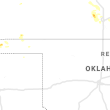
Oklahoma
| Local Time | Report Details |
|---|---|
| 3:32 PM CDT | Quarter sized hail reported near Catoosa, OK, 13.9 miles ENE of Tulsa, OK, quarter size hail estimated by nws employee in catoosa. |
| 3:33 PM CDT | Football equipment damage at catoosa high school via picture on social medi in rogers county OK, 15.1 miles ENE of Tulsa, OK |
| 4:35 PM CDT | Estimated 60 to 65 mph winds in checotah. time is radar estimate in mcintosh county OK, 53.9 miles SSE of Tulsa, OK |
| 4:35 PM CDT | Several 1 to 2 inch tree limbs down across checotah in mcintosh county OK, 53.9 miles SSE of Tulsa, OK |
| 7:14 PM CDT | Storm damage reported in texas county OK, 94.9 miles SSW of Garden City, KS |
| 7:20 PM CDT | Storm damage reported in texas county OK, 96.9 miles N of Amarillo, TX |
Colorado
| Local Time | Report Details |
|---|---|
| 3:04 PM MDT | Half Dollar sized hail reported near , , 28.5 miles NNW of Pueblo, CO, report from mping: half dollar (1.25 in.). |
| 3:06 PM MDT | Ping Pong Ball sized hail reported near , , 28.2 miles NNW of Pueblo, CO, report from mping: ping pong ball (1.50 in.). |
| 6:27 PM MDT | Quarter sized hail reported near Morrison, CO, 10.1 miles WSW of Denver, CO |
| 6:41 PM MDT | Quarter sized hail reported near Golden, CO, 15.6 miles W of Denver, CO |
| 6:45 PM MDT | Quarter sized hail reported near Denver, CO, 2.6 miles ESE of Denver, CO |
| 10:22 PM MDT | Quarter sized hail reported near Rocky Ford, CO, 53.3 miles ESE of Pueblo, CO, hailed for 20 minutes. |
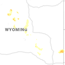
Wyoming
| Local Time | Report Details |
|---|---|
| 3:55 PM MDT | Ping Pong Ball sized hail reported near Lysite, WY, 34.2 miles ENE of Riverton, WY, public report on highway 26. driver estimated... but did not stop to measure and said the hail left dents in his truck. |
| 7:16 PM MDT | Mesonet station ew8925 linc in johnson county WY, 52.2 miles N of Casper, WY |
Maryland
| Local Time | Report Details |
|---|---|
| 6:10 PM EDT | Storm damage reported in prince georges county MD, 27.2 miles SW of Baltimore, MD |
| 6:10 PM EDT | Tree down on wires along dartmouth avenue in prince georges county MD, 28 miles SW of Baltimore, MD |
| 6:10 PM EDT | Several trees down along calvert road in prince georges county MD, 27.5 miles SW of Baltimore, MD |
| 6:10 PM EDT | Tree down on pony trail lane in prince georges county MD, 28.5 miles SW of Baltimore, MD |
| 6:14 PM EDT | Tree down on wires on newton street in prince georges county MD, 29.4 miles SW of Baltimore, MD |
| 6:47 PM EDT | Tree down on route 2 at old birdsville road in anne arundel county MD, 27 miles S of Baltimore, MD |
| 6:56 PM EDT | Large branch down on muddy creek road at shady oaks road in anne arundel county MD, 31.9 miles S of Baltimore, MD |
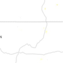
Kansas
| Local Time | Report Details |
|---|---|
| 5:45 PM CDT | Electrical line blown dow in seward county KS, 61.3 miles S of Garden City, KS |
| 6:35 PM CDT | Spotter estimated wind speeds approaching 60 mph at his location. hail was also occurring... but size is unknown since the spotter was driving at the tim in mcpherson county KS, 47.5 miles NW of Wichita, KS |
| 6:55 PM CDT | Estimated 60 to 70 mph winds in buhle in reno county KS, 39.2 miles NW of Wichita, KS |
| 7:01 PM CDT | Estimated 50 to 60 mph wind gusts east of buhler. small tree branches being blown dow in harvey county KS, 36.5 miles NNW of Wichita, KS |
| 7:19 PM CDT | Hen Egg sized hail reported near Haven, KS, 23.2 miles WNW of Wichita, KS, delayed report |
| 7:23 PM CDT | Delayed report. multiple trees down. tree on a car. power poles snapped. time estimated based on rada in harvey county KS, 28.7 miles NNW of Wichita, KS |
| 7:32 PM CDT | Multiple reports of trees down northeast of halstead. report via twitte in harvey county KS, 26.8 miles N of Wichita, KS |
| 7:34 PM CDT | Estimated 50-60 mph gusts and dime size hai in harvey county KS, 23.6 miles NNW of Wichita, KS |
| 7:50 PM CDT | Storm damage reported in sedgwick county KS, 13.4 miles W of Wichita, KS |
| 7:58 PM CDT | Storm damage reported in sedgwick county KS, 13.4 miles W of Wichita, KS |
| 7:58 PM CDT | 5 inch tree limb snapped at 5th ave. and vine st. delayed report. time based on radar dat in anderson county KS, 42.7 miles NNE of Chanute, KS |
| 8:01 PM CDT | Storm damage reported in sedgwick county KS, 13.4 miles W of Wichita, KS |
| 8:02 PM CDT | Half Dollar sized hail reported near Goddard, KS, 16.5 miles WSW of Wichita, KS |
| 8:09 PM CDT | Storm damage reported in sedgwick county KS, 6.2 miles WNW of Wichita, KS |
| 8:12 PM CDT | Storm damage reported in sedgwick county KS, 6 miles WSW of Wichita, KS |
| 8:18 PM CDT | Delayed report. tree down at oliver and lincoln. time estimated based on rada in sedgwick county KS, 3.3 miles ESE of Wichita, KS |
| 8:18 PM CDT | Storm damage reported in sedgwick county KS, 6 miles WSW of Wichita, KS |
| 8:21 PM CDT | Estimated 70 mph gust at i-235 and central. report via twitte in sedgwick county KS, 4.1 miles W of Wichita, KS |
| 8:37 PM CDT | Large tree down at estelle and funston in east wichita in sedgwick county KS, 1.9 miles S of Wichita, KS |
| 8:45 PM CDT | Storm damage reported in butler county KS, 14.3 miles ENE of Wichita, KS |
| 8:52 PM CDT | Tree limbs down and torrential rainfall in butler county KS, 21 miles ESE of Wichita, KS |
| 8:52 PM CDT | Storm damage reported in butler county KS, 19.4 miles SE of Wichita, KS |
| 9:16 PM CDT | Storm damage reported in butler county KS, 21.3 miles ESE of Wichita, KS |
| 9:20 PM CDT | Peak wind gust at strother field sw of winfield. gust associated with thunderstorm outflow wind in cowley county KS, 39.2 miles SSE of Wichita, KS |
| 9:28 PM CDT | Delayed report. mping report of 1-inch tree limbs broken and/or shingles blown of in butler county KS, 20 miles E of Wichita, KS |
| 9:47 PM CDT | Power lines down in butler county KS, 19.5 miles E of Wichita, KS |
Montana
| Local Time | Report Details |
|---|---|
| 7:14 PM MDT | Quarter sized hail reported near Great Falls, MT, 11.9 miles SSW of Great Falls, MT, quarter sized hail reported. |
| 1:17 AM UTC | Awos station k1im indi in cascade county MT, 15 miles SSW of Great Falls, MT |
| 1:55 AM UTC | Asos station kgtf great fall in cascade county MT, 4.3 miles SW of Great Falls, MT |
Illinois
| Local Time | Report Details |
|---|---|
| 9:45 PM CDT | Trees reported down along divide road and hwy 37 in northeast jefferson county. time estimate in jefferson county IL, 72.3 miles WNW of Evansville, IN |
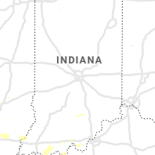
Indiana
| Local Time | Report Details |
|---|---|
| 11:55 PM CDT | Trees down in the wadesville area. time estimated by rada in posey county IN, 16.3 miles NW of Evansville, IN |
| 1:03 AM EDT | Emergency management reports trees down; power outage in knox county IN, 50.7 miles N of Evansville, IN |
| 1:07 AM EDT | Emergency manager reports trees down near old us 50 and overhead roa in knox county IN, 49 miles N of Evansville, IN |
Kentucky
| Local Time | Report Details |
|---|---|
| 5:24 AM EDT | Tree down near white tower elementary school. time estimated from rada in kenton county KY, 12.9 miles S of Cincinnati, OH |
| 5:48 AM EDT | Tree down. time estimated from rada in campbell county KY, 16.8 miles SE of Cincinnati, OH |
| 5:49 AM EDT | Tree down. time estimated from rada in campbell county KY, 17.1 miles SE of Cincinnati, OH |
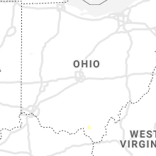
Ohio
| Local Time | Report Details |
|---|---|
| 5:51 AM EDT | Tree blown down. time estimated from rada in clermont county OH, 28.5 miles SE of Cincinnati, OH |
| 6:00 AM EDT | Tree down. time estimated from rada in clermont county OH, 20.8 miles SE of Cincinnati, OH |
Connect with Interactive Hail Maps