

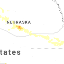
Hail Map for Tuesday, August 20, 2019

Number of Impacted Households on 8/20/2019
0
Impacted by 1" or Larger Hail
0
Impacted by 1.75" or Larger Hail
0
Impacted by 2.5" or Larger Hail
Square Miles of Populated Area Impacted on 8/20/2019
0
Impacted by 1" or Larger Hail
0
Impacted by 1.75" or Larger Hail
0
Impacted by 2.5" or Larger Hail


Cities Most Affected by Hail Storms of 8/20/2019
| Hail Size | Demographics of Zip Codes Affected | ||||||
|---|---|---|---|---|---|---|---|
| City | Count | Average | Largest | Pop Density | House Value | Income | Age |
| Wheatland, WY | 1 | 2.50 | 2.50 | 3 | $89k | $35.1k | 47.3 |
| Gill, CO | 1 | 1.75 | 1.75 | 24 | $111k | $43.1k | 36.7 |
| Grainfield, KS | 1 | 1.75 | 1.75 | 1 | $38k | $32.4k | 46.6 |
Hail and Wind Damage Spotted on 8/20/2019
Filter by Report Type:Hail ReportsWind Reports
States Impacted
Iowa, Illinois, Missouri, Minnesota, Indiana, West Virginia, Kentucky, Virginia, Ohio, Maryland, North Carolina, Tennessee, District of Columbia, Colorado, Michigan, Pennsylvania, Texas, Kansas, Arkansas, Wyoming, Oklahoma, Nebraska, New YorkIowa
| Local Time | Report Details |
|---|---|
| 7:44 AM CDT | Spotter report relayed by emergency managemen in henry county IA, 38.7 miles NNE of Kahoka, MO |
| 7:44 AM CDT | 4 to 5 foot diameter tree was snapped by the wind. time is estimated from rada in louisa county IA, 56.2 miles SSE of Cedar Rapids, IA |
| 7:50 AM CDT | Large 6-8 inch diameter tree down in backyard. received photo from social medi in des moines county IA, 37.2 miles NE of Kahoka, MO |
| 7:54 AM CDT | Report from mping: trees uprooted or snapped; roof blown of in polk county IA, 7 miles W of Des Moines, IA |
| 7:55 AM CDT | Storm damage reported in des moines county IA, 37.2 miles NE of Kahoka, MO |
| 7:55 AM CDT | Several reports of large trees and branches down... along with a leaning power pole being help by power line in des moines county IA, 50.2 miles NE of Kahoka, MO |
| 8:54 AM CDT | Report from mping: trees uprooted or snapped; roof blown of in warren county IA, 26.1 miles SSE of Des Moines, IA |
| 9:12 AM CDT | Ping Pong Ball sized hail reported near Algona, IA, 52.2 miles W of Mason City, IA |
Illinois
| Local Time | Report Details |
|---|---|
| 8:20 AM CDT | Trees and power lines down in monmouth and just to the north of the city. time estimated from rada in warren county IL, 57.2 miles WNW of Peoria, IL |
| 8:25 AM CDT | Several 8 inch diameter tree branches down. time estimated from rada in warren county IL, 56.9 miles W of Peoria, IL |
| 8:45 AM CDT | Numerous trees blown down across galesburg taking power lines down in knox county IL, 45.2 miles WNW of Peoria, IL |
| 8:48 AM CDT | Large tree limb down at 12th street and 25th ave in moline. report relayed by broadcast media. time estimated from rada in rock island county IL, 69.8 miles ESE of Cedar Rapids, IA |
| 8:50 AM CDT | Flattened corn and sorghum fields. relayed via wmbd-tv in knox county IL, 35.6 miles WNW of Peoria, IL |
| 8:55 AM CDT | Young cedar tree blown down. time estimate in fulton county IL, 38.2 miles W of Peoria, IL |
| 9:00 AM CDT | Tree limbs were blown down along us-24 from rushville to ray in schuyler county IL, 64.2 miles ESE of Kahoka, MO |
| 9:10 AM CDT | Large limbs down near 11th and ash street in fulton county IL, 25.5 miles WSW of Peoria, IL |
| 9:25 AM CDT | Tree blown down on a house in peoria west bluff near bradley university. time estimate in peoria county IL, 3.5 miles NNW of Peoria, IL |
| 9:25 AM CDT | Tree fell on a house in sunnylan in knox county IL, 41.8 miles WNW of Peoria, IL |
| 9:25 AM CDT | Tree fell on a house in sunnylan in tazewell county IL, 2.5 miles SE of Peoria, IL |
| 9:26 AM CDT | Large tree fell onto a power lin in mason county IL, 21.3 miles SSW of Peoria, IL |
| 9:30 AM CDT | One foot diameter tree down at parkview and 11th street... blocking the road. delayed repor in tazewell county IL, 8.7 miles SSW of Peoria, IL |
| 9:35 AM CDT | Power lines down. from emergency managemen in woodford county IL, 8.2 miles NE of Peoria, IL |
| 9:35 AM CDT | Large tree split down the middle. time estimate in tazewell county IL, 8.4 miles SE of Peoria, IL |
| 9:40 AM CDT | Two foot diameter trees blown down in deer cree in tazewell county IL, 14.2 miles ESE of Peoria, IL |
| 10:05 AM CDT | Power lines blown down in 2 locations in lincoln...leaving 500+ customers without powe in logan county IL, 39.1 miles SSE of Peoria, IL |
| 10:07 AM CDT | Storm damage reported in sangamon county IL, 59 miles S of Peoria, IL |
| 10:15 AM CDT | Trees down onto power lines on bel air drive in southeast springfield. from broadcast medi in sangamon county IL, 63 miles S of Peoria, IL |
| 10:15 AM CDT | Large pine tree blown down on house near jefferson street and churchill road in sangamon county IL, 59.7 miles S of Peoria, IL |
| 10:15 AM CDT | Numerous trees blown down on west side of springfield in sangamon county IL, 61.6 miles S of Peoria, IL |
| 10:15 AM CDT | Tree down blocking street. on 2nd street between kimble and st joseph street in sangamon county IL, 64.4 miles S of Peoria, IL |
| 10:15 AM CDT | Large tree down in mclean county IL, 42.3 miles SE of Peoria, IL |
| 10:23 AM CDT | Lines and poles dow in logan county IL, 53.7 miles NW of Mattoon, IL |
| 10:30 AM CDT | Large tree split in half on south alexander s in de witt county IL, 50 miles SE of Peoria, IL |
| 10:45 AM CDT | Tree limbs down. reported by off-duty nws employee. delayed repor in macon county IL, 39 miles NW of Mattoon, IL |
| 10:55 AM CDT | Tree blown down onto power line. relayed by wcia-tv. time estimate in piatt county IL, 32 miles NNW of Mattoon, IL |
| 10:55 AM CDT | Large trees snapped. relayed by wcia-tv. time estimate in champaign county IL, 48.9 miles N of Mattoon, IL |
| 11:00 AM CDT | Siding blown off of a building in bondville. delayed repor in champaign county IL, 42.7 miles N of Mattoon, IL |
| 11:02 AM CDT | Large tree snapped at the base... at intersection of kirby and crescen in champaign county IL, 43 miles N of Mattoon, IL |
| 11:11 AM CDT | Overturned semi on i 57 in champaign county IL, 51.9 miles N of Mattoon, IL |
| 11:20 AM CDT | Tree down in city in douglas county IL, 28.5 miles NNE of Mattoon, IL |
| 11:20 AM CDT | Storm damage reported in douglas county IL, 14.3 miles NNE of Mattoon, IL |
| 11:30 AM CDT | Tree blown down and fell onto power line. relayed by wcia-tv. time estimate in coles county IL, 9.4 miles NNE of Mattoon, IL |
| 11:36 AM CDT | Large tree limbs down. mping repor in douglas county IL, 27.7 miles NE of Mattoon, IL |
| 11:40 AM CDT | Trees down. from county emergency manage in vermilion county IL, 64.8 miles NNE of Mattoon, IL |
| 11:40 AM CDT | Trees down. from county emergency manage in vermilion county IL, 53.7 miles NE of Mattoon, IL |
| 11:45 AM CDT | Metal sign at a gas station blown down... minor roof damage to a house. delayed repor in vermilion county IL, 53.9 miles NE of Mattoon, IL |
| 11:50 AM CDT | Trees down. from county emergency manage in vermilion county IL, 68.3 miles NE of Mattoon, IL |
| 11:50 AM CDT | Trees down. from county emergency manage in vermilion county IL, 57.4 miles NE of Mattoon, IL |
| 11:50 AM CDT | Trees down. from county emergency manage in clay county IL, 42.3 miles S of Mattoon, IL |
| 11:50 AM CDT | Trees down. from county emergency manage in vermilion county IL, 55 miles NE of Mattoon, IL |
| 11:55 AM CDT | Trees down. from county emergency manager in vermilion county IL, 60.7 miles NE of Mattoon, IL |
| 11:56 AM CDT | Thunderstorm wind gusts blew 3 to 4 inch diameter tree branches down in vermilion county IL, 60.7 miles NE of Mattoon, IL |
| 11:56 AM CDT | Estimated a 50-60 mph wind gust from a thunderstorm in vermilion county IL, 60.7 miles NE of Mattoon, IL |
| 1:20 PM CDT | Siding off front of hous in white county IL, 45.3 miles WNW of Evansville, IN |
| 1:28 PM CDT | Large limbs down on edge of tow in wabash county IL, 32.6 miles NNW of Evansville, IN |
| 1:47 PM CDT | Reported at old plank otts drive chester medium-sized tree down in propert in randolph county IL, 45 miles NNW of Cape Girardeau, MO |
| 1:50 PM CDT | Reported at stratton st chester il tree downed by win in randolph county IL, 44.5 miles NNW of Cape Girardeau, MO |
| 3:52 PM CDT | Power lines down... power outages east half of the county and down to the metropolis area. strong winds also reported along 146 highway in pope count in massac county IL, 49.8 miles E of Cape Girardeau, MO |
Missouri
| Local Time | Report Details |
|---|---|
| 8:43 AM CDT | Quarter sized hail reported near Unionville, MO, 59.2 miles W of Kahoka, MO, relayed through the sheriff department. |
| 9:07 AM CDT | Reported at 6th st and lewis canton mo... 18-inch diameter tree dow in lewis county MO, 22.7 miles SSE of Kahoka, MO |
| 11:45 AM CDT | Half Dollar sized hail reported near Forest City, MO, 68.9 miles NNW of Kansas City, MO |
| 2:00 PM CDT | Tree(s) blocking the road at highway oo and highway f just southeast of farmington. time is estimated from radar. the call came in to dispatch at 2:40 p. in st. francois county MO, 48.5 miles WNW of Cape Girardeau, MO |
| 2:30 PM CDT | Tree(s) blocking the road at highway dd and old fredericktown road. time estimated from radar. call arrived at dispatch at 2:40 p. in st. francois county MO, 49.8 miles WNW of Cape Girardeau, MO |
| 2:33 PM CDT | Large tree blown onto a church causing moderate roof and guttering damage. numerous tree limbs blown down around tow in crawford county MO, 30.1 miles NNE of Salem, MO |
| 2:37 PM CDT | Trees down near county road 63 in perry county MO, 29.3 miles NW of Cape Girardeau, MO |
| 2:40 PM CDT | Part of a fence was blown down along with small tree branches. winds were estimated at 45 to 50 mp in phelps county MO, 25.4 miles NW of Salem, MO |
| 2:43 PM CDT | Downed tree(s) blocking the road at highway 00 and mine la motte road north of fredericktown. time is based on radar estimate. call arrived at dispatch at 14:5 in madison county MO, 44.9 miles WNW of Cape Girardeau, MO |
| 2:45 PM CDT | Tree blocking keysville rd. south of steelevill in crawford county MO, 24.3 miles NNE of Salem, MO |
| 2:45 PM CDT | 8 inch tree down on highway in iron county MO, 52.6 miles E of Salem, MO |
| 2:45 PM CDT | Three inch tree limbs down in rolla near the intersection of oak street and 14th street. time estimated from rada in phelps county MO, 25.7 miles NNW of Salem, MO |
| 2:52 PM CDT | Tree blocking city lake road just nw of fredericktown. time is based on radar estimate. call arrived at dispatch at 3:10 p.m in madison county MO, 45.5 miles WNW of Cape Girardeau, MO |
| 2:55 PM CDT | Quarter sized hail reported near Newburg, MO, 27.9 miles NW of Salem, MO |
| 2:56 PM CDT | Report from mping: tree and/or roof damage in cape girardeau county MO, 8 miles NNW of Cape Girardeau, MO |
| 3:10 PM CDT | Reported at berryman mo crawford co... large tree down outside of town. time reported was 2100z... but radar estimates damage at 2010 in crawford county MO, 30.8 miles NE of Salem, MO |
| 3:12 PM CDT | Storm damage reported in cape girardeau county MO, 4.1 miles NE of Cape Girardeau, MO |
| 3:19 PM CDT | Social media report of tree limbs down off of highway 72 near county road 542 in phelps county MO, 15.5 miles NW of Salem, MO |
| 3:29 PM CDT | Reports of power lines down in chaffe in scott county MO, 10.6 miles SW of Cape Girardeau, MO |
| 4:05 PM CDT | Tall narrow tree down on a home. non-shingle protective layer lifted from the current river inn. reported wind speed with this event was measured 46 mph by em offic in carter county MO, 52 miles SE of Salem, MO |
| 4:12 PM CDT | Multiple power poles and trees down at the intersection of farm road 219 and farm road 150. time estimated from rada in greene county MO, 8.3 miles ESE of Springfield, MO |
| 4:30 PM CDT | Trees down on highway 14 at dogwood hill. time estimated from rada in douglas county MO, 27.5 miles ESE of Springfield, MO |
| 4:39 PM CDT | Multiple 4-6 inch tree limbs down on bennett st. and a 10 inch limb down on a house on park st. in nixa. time estimated from rada in christian county MO, 11 miles S of Springfield, MO |
| 4:40 PM CDT | Tree down at the intersection of fairway st and fox terrace circle. time estimated from rada in christian county MO, 11 miles S of Springfield, MO |
| 4:44 PM CDT | Wright county sheriff reported a large tree down in norwood. delayed report. time estimated from rada in wright county MO, 49.1 miles E of Springfield, MO |
| 5:36 PM CDT | Estimated 60 mph wind gusts and pea sized hail on highway 76 between cape fair and reeds spring. time estimated from rada in stone county MO, 33.2 miles SSW of Springfield, MO |
| 5:25 AM CDT | Storm damage reported in daviess county MO, 64.6 miles NNE of Kansas City, MO |
| 6:05 AM CDT | 60 mph winds estimated... blew open caseys door in livingston county MO, 72.4 miles NE of Kansas City, MO |
Minnesota
| Local Time | Report Details |
|---|---|
| 9:00 AM CDT | Report relayed via tv media. downed trees and damage to buildings. broken glass on window in wright county MN, 31.4 miles WNW of Minneapolis, MN |
| 9:10 AM CDT | Report relayed via tv media. downed trees and damage to buildings. broken glass on window in wright county MN, 31.4 miles WNW of Minneapolis, MN |
Indiana
| Local Time | Report Details |
|---|---|
| 1:15 PM EDT | Multiple trees reported down near west lebano in warren county IN, 73.9 miles WNW of Indianapolis, IN |
| 1:16 PM EDT | Tree down on automobile. time estimated from rada in fountain county IN, 66.2 miles WNW of Indianapolis, IN |
| 1:18 PM EDT | A tree was reported down along state route 263 near county road 500 west. time is approximate based on rada in warren county IN, 71.4 miles NE of Mattoon, IL |
| 1:35 PM EDT | Multiple large tree limbs downed. time estimated from rada in fountain county IN, 63.5 miles WNW of Indianapolis, IN |
| 1:36 PM EDT | Utility line down in vigo county IN, 53.2 miles E of Mattoon, IL |
| 1:42 PM EDT | Large tree limbs snappe in fountain county IN, 55.1 miles WNW of Indianapolis, IN |
| 1:48 PM EDT | Dime sized hail was also note in owen county IN, 60.7 miles SW of Indianapolis, IN |
| 1:50 PM EDT | Utility lines down in fountain county IN, 63.5 miles WNW of Indianapolis, IN |
| 1:50 PM EDT | Tree snapped and dow in tippecanoe county IN, 60.8 miles NW of Indianapolis, IN |
| 1:51 PM EDT | Large limbs reported down in fountain county IN, 55.1 miles WNW of Indianapolis, IN |
| 2:01 PM EDT | Large limb of tree snapped off along indiana 47s. time estimated from rada in montgomery county IN, 44.6 miles WNW of Indianapolis, IN |
| 2:01 PM EDT | Emergency manager reports trees and tree limbs down across the county with some on car in putnam county IN, 38.5 miles W of Indianapolis, IN |
| 2:05 PM EDT | Located just west of teal and 52. small and medium size limbs dow in tippecanoe county IN, 57.7 miles NW of Indianapolis, IN |
| 2:05 PM EDT | Small and medium size tree limbs down just west of teal and 5 in tippecanoe county IN, 57.7 miles NW of Indianapolis, IN |
| 2:06 PM EDT | Tree limbs down on third street in tippecanoe county IN, 58.5 miles NW of Indianapolis, IN |
| 2:10 PM EDT | Doors blown off one or more buildings in montgomery county IN, 42.8 miles WNW of Indianapolis, IN |
| 2:13 PM EDT | Tree limbs down in fountain county IN, 60.9 miles WNW of Indianapolis, IN |
| 2:16 PM EDT | Multiple 5 to 7 inch tree limbs downe in greene county IN, 62.6 miles SW of Indianapolis, IN |
| 2:21 PM EDT | Utility lines down across road at elston road and old us 231 in tippecanoe county IN, 58 miles NW of Indianapolis, IN |
| 2:27 PM EDT | Several trees down in fountain county IN, 61.7 miles WNW of Indianapolis, IN |
| 2:35 PM EDT | Corrects previous tstm wnd dmg report from danville. several large trees down across danvill in hendricks county IN, 20.2 miles W of Indianapolis, IN |
| 2:40 PM EDT | Storm damage reported in greene county IN, 72.1 miles NNE of Evansville, IN |
| 2:41 PM EDT | Report from mping: trees uprooted or snapped; roof blown of in hendricks county IN, 18.6 miles W of Indianapolis, IN |
| 2:41 PM EDT | Report from mping: 1-inch tree limbs broken; shingles blown of in hendricks county IN, 17.1 miles WSW of Indianapolis, IN |
| 2:42 PM EDT | Tree down across 100 in hendricks county IN, 10.2 miles W of Indianapolis, IN |
| 2:43 PM EDT | Storm damage reported in marion county IN, 8.1 miles WSW of Indianapolis, IN |
| 2:43 PM EDT | *** 1 inj *** large tree snapped and fell on car driving along road. driver suffered minor injurie in marion county IN, 8.7 miles SW of Indianapolis, IN |
| 2:45 PM EDT | Large tree snapped off 15 feet above groun in marion county IN, 5.6 miles WSW of Indianapolis, IN |
| 2:52 PM EDT | Storm damage reported in johnson county IN, 18.6 miles S of Indianapolis, IN |
| 2:52 PM EDT | Storm damage reported in marion county IN, 3.7 miles NW of Indianapolis, IN |
| 2:55 PM EDT | Storm damage reported in brown county IN, 30.5 miles S of Indianapolis, IN |
| 2:58 PM EDT | 8 inch diameter tree down across roa in rush county IN, 36.2 miles SE of Indianapolis, IN |
| 3:01 PM EDT | Several large trees down across danvill in hendricks county IN, 20.2 miles W of Indianapolis, IN |
| 3:02 PM EDT | Tree down across highway 450 near brett roa in martin county IN, 64.5 miles NE of Evansville, IN |
| 3:05 PM EDT | Gazebo ripped out of the ground and thrown against a hous in marion county IN, 11.3 miles SE of Indianapolis, IN |
| 3:07 PM EDT | Several large tree limbs downed with a couple small trees snapped at the location. time estimated from rada in johnson county IN, 16.7 miles SSE of Indianapolis, IN |
| 3:07 PM EDT | Report of trees down in nw decatur count in decatur county IN, 38.3 miles SE of Indianapolis, IN |
| 3:07 PM EDT | Large tree limbs down with several small trees snapped at the location. time estimated from rada in johnson county IN, 15.5 miles SSE of Indianapolis, IN |
| 3:15 PM EDT | Storm damage reported in brown county IN, 30.5 miles S of Indianapolis, IN |
| 2:17 PM CDT | 58 mph gust measured by the aso in vanderburgh county IN, 5.9 miles NNE of Evansville, IN |
| 3:21 PM EDT | Em reports tree down at 15th and leopold in jasper. also reports transformer on fire at 9th and mcarthur in jaspe in dubois county IN, 44.3 miles NE of Evansville, IN |
| 3:30 PM EDT | 2 power poles snapped along road. time estimated from rada in lawrence county IN, 66.1 miles NW of Louisville, KY |
| 3:33 PM EDT | Trees and power lines down on 525w and sr13 in madison county IN, 26.3 miles NE of Indianapolis, IN |
| 2:36 PM CDT | Estimated 50 to 60 mph winds with small tree limbs dow in spencer county IN, 34 miles ENE of Evansville, IN |
| 3:37 PM EDT | Trees and power lines were reported down near waldron. the approximate time of this event was based on rada in shelby county IN, 33.7 miles SE of Indianapolis, IN |
| 2:42 PM CDT | Tree fell on structure in patronvill in spencer county IN, 27.1 miles ESE of Evansville, IN |
| 3:46 PM EDT | Corrects previous tstm wnd dmg report from 3 e saint paul. reports of trees down from st. paul to greensburg. 150+ currently without power due to storm in decatur county IN, 38.3 miles SE of Indianapolis, IN |
| 3:46 PM EDT | Reports of trees down in nw part of decatur count in decatur county IN, 38.3 miles SE of Indianapolis, IN |
| 4:00 PM EDT | Tree and power pole/lines down across road. time estimated from rada in crawford county IN, 43.9 miles NW of Louisville, KY |
| 4:19 PM EDT | Trampoline flipped from neighbors home... a support pole snapped off and pierced completely through siding of house... knocking a coffee machine over on hummingbird cou in dearborn county IN, 27.9 miles WNW of Cincinnati, OH |
| 4:20 PM EDT | Tree down on dogwood court. power lines down near east central high schoo in dearborn county IN, 27.4 miles WNW of Cincinnati, OH |
| 4:25 PM EDT | Tree down on barber roa in dearborn county IN, 25.1 miles WNW of Cincinnati, OH |
West Virginia
| Local Time | Report Details |
|---|---|
| 1:37 PM EDT | One tree down in camp creek state par in mercer county WV, 64.3 miles SSE of Charleston, WV |
| 2:00 PM EDT | Three trees down on old scherr roa in grant county WV, 42.2 miles ENE of Elkins, WV |
| 2:15 PM EDT | Two trees down near intersection of morgantown and knobly road in grant county WV, 40.2 miles ENE of Elkins, WV |
| 2:30 PM EDT | Few small trees down near intersection of us rt. 220 and schmucker rd in pendleton county WV, 31.8 miles ESE of Elkins, WV |
| 2:33 PM EDT | Tree down near intersection of martinsburg road and potomac roa in morgan county WV, 81.7 miles S of State College, PA |
| 3:05 PM EDT | Tree down on rig roa in hardy county WV, 45.8 miles ENE of Elkins, WV |
| 8:40 PM EDT | 6 trees down near kelly's creek in kanawha county WV, 15.1 miles ESE of Charleston, WV |
| 9:20 PM EDT | Tree down blocking road on stateridge r in tyler county WV, 69.2 miles NW of Elkins, WV |
| 9:20 PM EDT | 1 tree down on wick r in tyler county WV, 68.1 miles WNW of Elkins, WV |
| 10:20 PM EDT | A tree down in summit park. asos at nearby kckb reported a wind gust of 41 mp in harrison county WV, 35.8 miles NW of Elkins, WV |
| 10:20 PM EDT | Tree down on cost av in harrison county WV, 33.6 miles NW of Elkins, WV |
| 10:26 PM EDT | Tree down on carolina roa in marion county WV, 43.8 miles NNW of Elkins, WV |
| 10:27 PM EDT | Tree down on summit park av in harrison county WV, 35.4 miles NW of Elkins, WV |
| 10:28 PM EDT | Tree down on sun valley r in harrison county WV, 39.9 miles NW of Elkins, WV |
| 10:30 PM EDT | A number of trees down across marion count in marion county WV, 49.5 miles NNW of Elkins, WV |
| 10:45 PM EDT | Tree down near covered bridg in harrison county WV, 42.9 miles NW of Elkins, WV |
| 10:52 PM EDT | 4 tress down near lost creek off of 1-7 in harrison county WV, 31.7 miles WNW of Elkins, WV |
| 10:52 PM EDT | Power lines down on halls run r in harrison county WV, 43.5 miles WNW of Elkins, WV |
| 11:02 PM EDT | Tree down on bices run r in harrison county WV, 42.4 miles NW of Elkins, WV |
| 11:18 PM EDT | Tree down in milford-laurel par in harrison county WV, 35.9 miles WNW of Elkins, WV |
Kentucky
| Local Time | Report Details |
|---|---|
| 1:52 PM EDT | Numerous trees down on mountain parkway. clay city fire department and road department on the scen in powell county KY, 15.2 miles N of Irvine, KY |
| 2:45 PM EDT | Report of a tree down on hinton webber roa in harrison county KY, 43.9 miles S of Cincinnati, OH |
| 3:07 PM EDT | Tree and power lines down along caney fork roa in casey county KY, 58 miles SE of Louisville, KY |
| 3:42 PM EDT | Small branches snapped from tree. time estimated from rada in kenton county KY, 13.1 miles S of Cincinnati, OH |
| 2:50 PM CDT | Isolated tree damage relayed via social media... pictures. mostly minor. two larger limbs... couple of trees seemed stressed or partially rotted out. peak wind at the a in daviess county KY, 28.5 miles ESE of Evansville, IN |
| 3:45 PM CDT | Wind caused power line at dairy queen to fall down on top of a car. shortly after the car caught on fir in ohio county KY, 53.2 miles SE of Evansville, IN |
| 3:45 PM CDT | Report from mping: 1-inch tree limbs broken; shingles blown of in muhlenberg county KY, 53.3 miles SSE of Evansville, IN |
| 3:50 PM CDT | Trees reported down on teller haycraft lane and hwy 11 in breckinridge county KY, 46.6 miles WSW of Louisville, KY |
| 3:58 PM CDT | Tree limbs down and power outage in ballard county KY, 33 miles ESE of Cape Girardeau, MO |
| 4:58 PM EDT | Trees down on hwy 1005 near bagdad and hwy 395 near wadd in shelby county KY, 36.3 miles ENE of Louisville, KY |
| 5:10 PM EDT | Trees reported down at intersection of new glendale rd and brentwood drive. trees also reported down on senora nolin r in hardin county KY, 27.1 miles SSW of Louisville, KY |
| 5:12 PM EDT | Tree blocking new fox r in estill county KY, 6.7 miles NW of Irvine, KY |
| 5:18 PM EDT | Extremely large hickory tree has fallen across hwy 89 near the intersection of hwy 82 and is completely blocking the roa in estill county KY, 5.8 miles NNW of Irvine, KY |
| 5:18 PM EDT | Tree partially blocking road on hwy 89 near the hargett fire departmen in estill county KY, 6 miles NNW of Irvine, KY |
| 5:21 PM EDT | Large tree down blocking sandhill rd just pass mile marker in estill county KY, 4.1 miles NW of Irvine, KY |
| 4:25 PM CDT | From trained spotter: leitchfield police report tree down across nelson rd in clarkson. time estimated from rada in grayson county KY, 44.6 miles SW of Louisville, KY |
| 5:30 PM EDT | Several trees down along lost creek road in northern perry count in perry county KY, 46.5 miles ESE of Irvine, KY |
| 4:41 PM CDT | Report from mping: 1-inch tree limbs broken; shingles blown of in muhlenberg county KY, 57.6 miles SSE of Evansville, IN |
| 4:45 PM CDT | Trees reported down on briggs hill rd and old scottsville r in warren county KY, 59.8 miles NNE of Nashville, TN |
| 4:54 PM CDT | Asos reports gust of 52.0 knots from north at kbw in warren county KY, 58.8 miles NNE of Nashville, TN |
| 5:00 PM CDT | Trees reported down along ky8 in hart county KY, 52.3 miles S of Louisville, KY |
| 5:00 PM CDT | Photos of large downed tree on a garage. time estimated from rada in warren county KY, 58.3 miles NNE of Nashville, TN |
| 6:25 PM EDT | Tree reported down on old hodgenville rd and power line reported down on smith ridge r in taylor county KY, 47.7 miles SSE of Louisville, KY |
| 6:43 PM EDT | Trees down at campground near buckhorn lake. report via social medi in perry county KY, 37.2 miles SE of Irvine, KY |
| 7:10 PM EDT | Trees and power lines down on route 1690 near cherryville. time estimated from rada in lawrence county KY, 55.2 miles WSW of Charleston, WV |
| 7:48 PM EDT | Numerous large trees and power lines down on highway 6 in bell county KY, 60 miles SSE of Irvine, KY |
Virginia
| Local Time | Report Details |
|---|---|
| 2:06 PM EDT | Tree down on brooks mill r in franklin county VA, 19.4 miles SSE of Roanoke, VA |
| 2:11 PM EDT | Tree down on 3 oaks r in franklin county VA, 15.3 miles SE of Roanoke, VA |
| 2:12 PM EDT | Porch torn off a house... and blown 100 feet into the backyard. multiple tree limbs dow in franklin county VA, 15 miles SSE of Roanoke, VA |
| 2:12 PM EDT | Power line down off burnt chimney roa in franklin county VA, 15 miles SSE of Roanoke, VA |
| 2:20 PM EDT | Large limbs dow in pulaski county VA, 43.2 miles WSW of Roanoke, VA |
| 2:20 PM EDT | Quarter sized hail reported near Dublin, VA, 43.2 miles WSW of Roanoke, VA |
| 2:41 PM EDT | Large tree limbs down off route 73 in bedford county VA, 26.7 miles ESE of Roanoke, VA |
| 4:12 PM EDT | One tree down... and a couple of large limbs dow in amherst county VA, 46 miles NE of Roanoke, VA |
| 4:30 PM EDT | Large limbs dow in buckingham county VA, 40.1 miles W of Richmond, VA |
| 4:37 PM EDT | Tree down at 13700 north valley pike in rockingham county VA, 65.3 miles ESE of Elkins, WV |
| 4:37 PM EDT | Tree down onto wires near north valley pike and endless caverns rd in rockingham county VA, 65.5 miles ESE of Elkins, WV |
| 4:50 PM EDT | Storm damage reported in shenandoah county VA, 63.9 miles ESE of Elkins, WV |
| 4:53 PM EDT | Tree down on piney woods roa in rockingham county VA, 64.2 miles ESE of Elkins, WV |
| 4:58 PM EDT | Tree down blocking south lakes dr at reston pkwy in fairfax county VA, 47 miles WSW of Baltimore, MD |
| 5:03 PM EDT | One tree and several large limbs down throughout the franklin glen subdivisio in fairfax county VA, 50.8 miles WSW of Baltimore, MD |
| 5:07 PM EDT | Tree down on green hill roa in rockingham county VA, 60.1 miles ESE of Elkins, WV |
| 5:16 PM EDT | Tree down on nazarene church r in rockingham county VA, 57 miles SE of Elkins, WV |
| 5:19 PM EDT | Tree down on a house in the 3400 block of beaver dam rd... and another tree down in the 3500 block of beaver dam rd. time estimated by rada in isle of wight county VA, 45.1 miles W of Virginia Beach, VA |
| 5:19 PM EDT | Large tree down blocking dranesville road at powells tavern plac in fairfax county VA, 46 miles WSW of Baltimore, MD |
| 5:20 PM EDT | Tree down on rt 201 causing power outages in the area. time estimated by rada in northumberland county VA, 70.3 miles ENE of Richmond, VA |
| 5:20 PM EDT | Several trees down... including some on cars and house in isle of wight county VA, 42.9 miles W of Virginia Beach, VA |
| 5:22 PM EDT | Quarter sized hail reported near Herndon, VA, 45.3 miles WSW of Baltimore, MD |
| 5:26 PM EDT | Quarter sized hail reported near Abingdon, VA, 11.8 miles ENE of Bristol, TN |
| 6:00 PM EDT | Wires down on st. louis roa in loudoun county VA, 66.5 miles WSW of Baltimore, MD |
| 6:09 PM EDT | Tree and limbs down on chase lan in city of fredericks county VA, 54.9 miles N of Richmond, VA |
| 6:14 PM EDT | Wires down on shoemaker school roa in loudoun county VA, 61.7 miles WSW of Baltimore, MD |
| 6:15 PM EDT | Tree down on sunken meadow road. time estimated from rada in surry county VA, 45.1 miles ESE of Richmond, VA |
| 6:17 PM EDT | Tree down near intersection of waterway dr and widewater dr in prince william county VA, 62 miles SW of Baltimore, MD |
| 6:20 PM EDT | Tree down in newland. in addition... four homes were struck by lightning. time estimated from rada in richmond county VA, 57 miles NE of Richmond, VA |
| 6:21 PM EDT | Large tree down at 15719 cranberry c in prince william county VA, 60.9 miles SW of Baltimore, MD |
| 6:27 PM EDT | Tree down on delta diamond lan in loudoun county VA, 56 miles WSW of Baltimore, MD |
| 6:30 PM EDT | Multiple trees down and power outages throughout the city of franklin. time estimated by rada in city of franklin county VA, 48.1 miles W of Virginia Beach, VA |
| 6:33 PM EDT | Tree down on east colonial highway at canby road in loudoun county VA, 55.2 miles W of Baltimore, MD |
| 6:40 PM EDT | Multiple trees down at bullitt par in wise county VA, 36.5 miles WNW of Bristol, TN |
| 6:41 PM EDT | Storm damage reported in anz536 county VA, 65.2 miles NNE of Richmond, VA |
| 6:44 PM EDT | Tree down at 4136 anderson rd in prince william county VA, 64.5 miles SW of Baltimore, MD |
| 6:45 PM EDT | Multiple trees dow in sussex county VA, 50.3 miles SE of Richmond, VA |
| 6:50 PM EDT | Large tree down near intersection of cockpit point ln and possum point rd in prince william county VA, 63.1 miles SW of Baltimore, MD |
| 7:00 PM EDT | Multiple trees down in colonial beach including one tree down on a residence. time estimated from rada in westmoreland county VA, 64.4 miles NE of Richmond, VA |
| 7:06 PM EDT | A few trees down on port conway roa in king george county VA, 54.6 miles NNE of Richmond, VA |
| 7:34 PM EDT | Several trees down on caledon driv in king george county VA, 59.6 miles NNE of Richmond, VA |
| 7:45 PM EDT | Large tree uprooted near intersection of port conway rd and james madison parkway in king george county VA, 53.9 miles NNE of Richmond, VA |
| 7:48 PM EDT | Large tree uprooted near intersection of dahlgren rd and indiantown rd in king george county VA, 60 miles NNE of Richmond, VA |
| 8:58 PM EDT | Tree uprooted near intersection of pine hill rd and melody ln in king george county VA, 60.2 miles NNE of Richmond, VA |
Ohio
| Local Time | Report Details |
|---|---|
| 2:08 PM EDT | Quarter sized hail reported near Yellow Springs, OH, 51 miles W of Columbus, OH |
| 3:40 PM EDT | Numerous large limbs and a couple of large trees broken in hamilton county OH, 9.6 miles WNW of Cincinnati, OH |
| 3:52 PM EDT | 12-inch diameter branch split from tree. photo verified. time estimated from rada in franklin county OH, 7.3 miles SSW of Columbus, OH |
| 3:52 PM EDT | Numberous 2-4 inch branches down at eastfield drive and frank road. time estimated from rada in franklin county OH, 3.8 miles SW of Columbus, OH |
| 4:16 PM EDT | Tree down. time estimated by rada in marion county OH, 34 miles N of Columbus, OH |
| 4:21 PM EDT | One large tree downed on a house along miami av in hamilton county OH, 10.1 miles NE of Cincinnati, OH |
| 4:22 PM EDT | Image of tree split... lying across both lanes in the road. tree had some rot. location is approximat in henry county OH, 61.9 miles E of Fort Wayne, IN |
| 4:35 PM EDT | 12-inch diameter branch snapped off tre in hamilton county OH, 16 miles NE of Cincinnati, OH |
| 4:51 PM EDT | Tree down on west vine stree in knox county OH, 39.8 miles NE of Columbus, OH |
| 5:18 PM EDT | Multiple trees dow in wood county OH, 87.9 miles ENE of Fort Wayne, IN |
| 5:26 PM EDT | Large tree uprooted. time estimated from rada in richland county OH, 59 miles NNE of Columbus, OH |
| 5:27 PM EDT | Tree down near the intersection of baird and pelton road in wood county OH, 84.8 miles E of Fort Wayne, IN |
| 5:28 PM EDT | Tree and wires dow in wood county OH, 90.3 miles W of Cleveland, OH |
| 5:30 PM EDT | Tree down near intersection of hastings newville rd and pleasant valley r in richland county OH, 57 miles NNE of Columbus, OH |
| 5:51 PM EDT | Section of large tree down on hous in richland county OH, 57.3 miles SW of Cleveland, OH |
| 5:54 PM EDT | Trees and wires down reported at brookside park in ashlan in ashland county OH, 55 miles SW of Cleveland, OH |
| 6:05 PM EDT | Tree branches down on vehicles causing damag in sandusky county OH, 68.3 miles W of Cleveland, OH |
| 6:25 PM EDT | Tree down near the intersection of behlman and west fick road in ottawa county OH, 74.7 miles W of Cleveland, OH |
| 6:26 PM EDT | Large tree down across robert lucas road. time estimated from rada in scioto county OH, 74.6 miles S of Columbus, OH |
| 6:46 PM EDT | Large tree down across white gravel road near mcdaniels road. time estimated from rada in scioto county OH, 72 miles WNW of Charleston, WV |
| 6:51 PM EDT | Tree down near route 30 and honeytown roa in wayne county OH, 49.6 miles SSW of Cleveland, OH |
| 6:51 PM EDT | Large tree down on county road 400 and township road 30 in holmes county OH, 67.2 miles NE of Columbus, OH |
| 7:02 PM EDT | Numerous tree limbs down. estimated wind gusts of 50 to 60 mp in holmes county OH, 62.8 miles S of Cleveland, OH |
| 7:06 PM EDT | Large tree limbs dow in wayne county OH, 36.9 miles S of Cleveland, OH |
| 7:45 PM EDT | Numerous trees and power lines down along rock run roa in jackson county OH, 62.6 miles SSE of Columbus, OH |
| 8:02 PM EDT | Trees and wires down along stone creek road in tuscarawas county OH, 75.9 miles S of Cleveland, OH |
| 8:36 PM EDT | 2 inch tree limbs down in newpor in washington county OH, 75 miles NNE of Charleston, WV |
| 8:40 PM EDT | A number of trees down across tuscarawas county in tuscarawas county OH, 68.2 miles W of Pittsburgh, PA |
| 8:50 PM EDT | A number of trees down in southern parts of tuscarawas county in tuscarawas county OH, 70.3 miles W of Pittsburgh, PA |
| 9:05 PM EDT | A number of trees down across harrison county in harrison county OH, 63.5 miles W of Pittsburgh, PA |
| 9:10 PM EDT | Number of trees and power lines down across the town of sci in harrison county OH, 57.7 miles W of Pittsburgh, PA |
| 9:40 PM EDT | Tree down along route 4 in belmont county OH, 53.7 miles WSW of Pittsburgh, PA |
Maryland
| Local Time | Report Details |
|---|---|
| 3:11 PM EDT | Widespread tree damage along mount holly road in east new market. small hail also reporte in dorchester county MD, 49.1 miles WNW of Ocean City, MD |
| 3:30 PM EDT | Numerous trees down and widespread wind damage between east new market and secretar in dorchester county MD, 48.9 miles WNW of Ocean City, MD |
| 3:41 PM EDT | A few trees down. time estimated from rada in talbot county MD, 52.6 miles SE of Baltimore, MD |
| 3:50 PM EDT | Some trees down including one onto a house on jefferies road. time estimated from rada in talbot county MD, 47.4 miles SE of Baltimore, MD |
| 4:37 PM EDT | Tree knocked down onto a house at 4812 western ave in montgomery county MD, 35.3 miles SW of Baltimore, MD |
| 4:38 PM EDT | Large tree down onto utility wires near intersection of onondaga rd and massachusetts ave. onondaga rd blocked to traffi in montgomery county MD, 35.7 miles SW of Baltimore, MD |
| 4:41 PM EDT | Tree branches and wires down near intersection of connecticut ave and dresden s in montgomery county MD, 31.4 miles SW of Baltimore, MD |
| 4:45 PM EDT | Storm damage reported in prince georges county MD, 36.6 miles SSW of Baltimore, MD |
| 5:01 PM EDT | Half Dollar sized hail reported near Andrews Air Force Base, MD, 36.6 miles SSW of Baltimore, MD |
| 5:10 PM EDT | Quarter sized hail reported near Temple Hills, MD, 36.5 miles SSW of Baltimore, MD |
| 5:48 PM EDT | Tree knocked down onto garage at 26268 forest hall d in st. marys county MD, 63 miles S of Baltimore, MD |
| 5:50 PM EDT | Tree across road near intersection of morganza turner rd and johnson manor farm ln in st. marys county MD, 61.6 miles S of Baltimore, MD |
| 5:51 PM EDT | Tree blocking road at 25665 colton point rd in st. marys county MD, 63.7 miles S of Baltimore, MD |
| 5:52 PM EDT | Tree blocking road near colton point rd and doctor johnson rd in st. marys county MD, 64.4 miles S of Baltimore, MD |
| 5:57 PM EDT | Tree down blocking road near friendship school rd in st. marys county MD, 64.9 miles S of Baltimore, MD |
| 6:04 PM EDT | Tree onto powerlines across the road at 28930 point lookout rd in st. marys county MD, 63.7 miles S of Baltimore, MD |
| 6:05 PM EDT | Several trees down onto reintzell lane in st. marys county MD, 63.6 miles S of Baltimore, MD |
| 6:06 PM EDT | Tree partially blocking road on laurel grove rd in st. marys county MD, 62.2 miles S of Baltimore, MD |
| 6:11 PM EDT | Trees down onto wires and utility poles near intersection of georgia ave and gregg rd. damage to utility poles. both directions of georgia ave blocke in montgomery county MD, 25.5 miles WSW of Baltimore, MD |
| 6:12 PM EDT | Tree over road at 27180 point lookout rd in st. marys county MD, 66.4 miles S of Baltimore, MD |
| 6:14 PM EDT | Tree blocking road at 25601 friendship school rd in st. marys county MD, 63.5 miles S of Baltimore, MD |
| 7:12 PM EDT | Tree down onto wires along kemp ln in frederick county MD, 46.7 miles WNW of Baltimore, MD |
| 7:14 PM EDT | Tree down near intersection of rocky springs rd and old receiver rd in frederick county MD, 46.8 miles WNW of Baltimore, MD |
| 7:16 PM EDT | Tree down along ellsworth way in frederick county MD, 46.3 miles WNW of Baltimore, MD |
| 7:27 PM EDT | Tree down in new midway in frederick county MD, 41.2 miles WNW of Baltimore, MD |
| 7:32 PM EDT | Tree down along legore bridge rd in frederick county MD, 42.5 miles WNW of Baltimore, MD |
North Carolina
| Local Time | Report Details |
|---|---|
| 4:09 PM EDT | Tree down near nc-109 s and mckay hill rd in mount gilea in montgomery county NC, 46.3 miles E of Charlotte, NC |
Tennessee
| Local Time | Report Details |
|---|---|
| 3:15 PM CDT | Roof damage occurred to a business with part of a roof blown onto lebanon pik in davidson county TN, 3 miles ESE of Nashville, TN |
| 3:30 PM CDT | Power lines were knocked down and a power pole was snapped near the intersection of douglas and stainback in east nashvill in davidson county TN, 1.6 miles NNE of Nashville, TN |
| 3:30 PM CDT | Numerous limbs were blown down in and around shelby par in davidson county TN, 3.3 miles E of Nashville, TN |
| 3:30 PM CDT | A 10 inch diameter tree was blwon down in the lockland springs communit in davidson county TN, 2.3 miles ENE of Nashville, TN |
| 7:22 PM CDT | Tree down at okolona and oak hill roads in overton county TN, 80.7 miles E of Nashville, TN |
| 9:00 PM EDT | Corrects previous tstm wnd dmg report... incorrect location. tree down at 1515 ridge road and another on east ridge roa in sevier county TN, 22.4 miles ESE of Knoxville, TN |
| 9:00 PM EDT | Tree down on ridge road and east ridge roa in sevier county TN, 16.6 miles SE of Knoxville, TN |
District of Columbia
| Local Time | Report Details |
|---|---|
| 4:39 PM EDT | Quarter sized hail reported near Washington, DC, 34.2 miles SW of Baltimore, MD, quarter size hail in cleveland park neighborhood of dc. |
| 4:45 PM EDT | Large limbs down on 16th street northwest at spring road northwes in district of columb county DC, 33.5 miles SW of Baltimore, MD |
| 5:01 PM EDT | Large branch down along 5400 block of chevy chase parkway n in district of columb county DC, 33.6 miles SW of Baltimore, MD |
| 5:44 PM EDT | Half Dollar sized hail reported near Washington, DC, 36.2 miles SW of Baltimore, MD |
| 5:47 PM EDT | Half Dollar sized hail reported near Washington, DC, 35.6 miles SW of Baltimore, MD |
Colorado
| Local Time | Report Details |
|---|---|
| 4:10 PM MDT | Ping Pong Ball sized hail reported near Gill, CO, 58.9 miles NNE of Denver, CO, corrects previous hail report from 2 e galeton. report via twitter. |
| 4:18 PM MDT | Golf Ball sized hail reported near Gill, CO, 60 miles NNE of Denver, CO |
| 4:40 PM MDT | Ping Pong Ball sized hail reported near Gill, CO, 58.9 miles NNE of Denver, CO, report via twitter. |
| 4:46 PM MDT | Quarter sized hail reported near Eaton, CO, 60.4 miles NNE of Denver, CO, strong gusty winds. |
| 5:43 PM MDT | Quarter sized hail reported near Roggen, CO, 41.8 miles NE of Denver, CO |
| 6:04 PM MDT | Ping Pong Ball sized hail reported near Keenesburg, CO, 42.8 miles NE of Denver, CO |
| 6:04 PM MDT | Ping Pong Ball sized hail reported near Roggen, CO, 41.2 miles NE of Denver, CO, report from mping: ping pong ball (1.50 in.). |
| 6:45 PM MDT | Quarter sized hail reported near Strasburg, CO, 38.1 miles ENE of Denver, CO |
Michigan
| Local Time | Report Details |
|---|---|
| 6:17 PM EDT | Tree down on road near bliven and braden rd in shiawassee county MI, 23.9 miles SW of Flint, MI |
| 6:20 PM EDT | Large tree down blocking roadway near secor and sterns rd in monroe county MI, 87.1 miles S of Flint, MI |
| 9:10 PM EDT | Large tree downed in casco townshi in st. clair county MI, 55.2 miles ESE of Flint, MI |
Pennsylvania
| Local Time | Report Details |
|---|---|
| 6:38 PM EDT | Multiple trees down on thorley roa in york county PA, 63.8 miles N of Baltimore, MD |
| 6:46 PM EDT | Trees down on wires on lumber stree in dauphin county PA, 64.7 miles N of Baltimore, MD |
| 6:51 PM EDT | Trees down on a house on north union street and on a house at 16 park circl in dauphin county PA, 64.4 miles N of Baltimore, MD |
| 7:07 PM EDT | Several large branches down on cocoa avenu in dauphin county PA, 66.2 miles N of Baltimore, MD |
| 7:11 PM EDT | Multiple trees down in the cambridge commons and glenn acres neighborhood in dauphin county PA, 68.3 miles N of Baltimore, MD |
Texas
| Local Time | Report Details |
|---|---|
| 6:02 PM CDT | Storm damage reported in armstrong county TX, 48.5 miles ESE of Amarillo, TX |
Kansas
| Local Time | Report Details |
|---|---|
| 6:15 PM CDT | Golf Ball sized hail reported near Grainfield, KS, 41.2 miles SE of Colby, KS, relayed via spotter from family member. up to golf ball size hail reported. time approximated from radar. |
| 6:15 PM CDT | Quarter sized hail reported near Grainfield, KS, 41.6 miles SE of Colby, KS, time approximated by radar. |
| 6:30 PM CDT | Side wall of implement shed blown down. time is approximat in kiowa county KS, 75 miles N of Woodward, OK |
| 7:40 PM CDT | Dime to nickel size hail reported with winds up to 70mph in chase. reports received of shingles being blown off of roofs as wel in rice county KS, 63.8 miles ESE of Hays, KS |
| 7:45 PM CDT | Quarter sized hail reported near Chase, KS, 60.7 miles SE of Hays, KS |
| 12:30 AM CDT | Awos station khys hays regional airport awos sit in ellis county KS, 3.7 miles ESE of Hays, KS |
Arkansas
| Local Time | Report Details |
|---|---|
| 6:15 PM CDT | Multiple trees down... blocking lanes on highway 6 in fulton county AR, 88.1 miles S of Salem, MO |
Wyoming
| Local Time | Report Details |
|---|---|
| 5:22 PM MDT | Quarter sized hail reported near Douglas, WY, 48.4 miles E of Casper, WY, report from mping: quarter (1.00 in.). |
| 5:23 PM MDT | Quarter sized hail reported near Cheyenne, WY, 47.6 miles SW of Scottsbluff, NE, report from mping: quarter (1.00 in.). |
| 5:40 PM MDT | Ping Pong Ball sized hail reported near Wheatland, WY, 69.9 miles NNE of Laramie, WY, report received via facebook. interstate 25 mile marker 94. |
| 5:47 PM MDT | Quarter sized hail reported near Douglas, WY, 48.1 miles E of Casper, WY |
| 6:00 PM MDT | Quarter sized hail reported near Glendo, WY, 71.9 miles ESE of Casper, WY, report received from platte county emergency manager. |
| 6:00 PM MDT | Half Dollar sized hail reported near Wheatland, WY, 65.6 miles NNE of Laramie, WY, dan fitts report from twitter. |
| 6:34 PM MDT | Tennis Ball sized hail reported near Wheatland, WY, 50.9 miles NNE of Laramie, WY, storm chaser measured tennis ball sized hail. hwy 34 mm42 near sybille creek. |
| 6:40 PM MDT | Ping Pong Ball sized hail reported near Wheatland, WY, 52 miles NNE of Laramie, WY |
| 11:00 PM MDT | Half Dollar sized hail reported near Albin, WY, 38 miles SW of Scottsbluff, NE, report on facebook of half dollar sized hail in albin. |
Oklahoma
| Local Time | Report Details |
|---|---|
| 8:15 PM CDT | Several damaged store fronts and multiple reports of roof damage to businesses and homes. a few cars were moved from their original location prior to the wind. time est in pittsburg county OK, 42.7 miles NNE of Atoka, OK |
Nebraska
| Local Time | Report Details |
|---|---|
| 10:27 PM MDT | Large rv trailer blown over in roddoux rv park in gering nebraska. photos relayed from social media. time is estimated based on nearby report in scotts bluff county NE, 2.2 miles S of Scottsbluff, NE |
| 10:33 PM MDT | Corrects previous tstm wnd gst report from 1 e scottsbluff. kneb weather station reported a 91 mph wind gust with extensive tree damage nearb in scotts bluff county NE, 1.3 miles ENE of Scottsbluff, NE |
| 10:34 PM MDT | Report from mping: 1-inch tree limbs broken; shingles blown of in scotts bluff county NE, 2.9 miles S of Scottsbluff, NE |
| 10:34 PM MDT | Spotter reported estimated wind gusts of 55 to 60 mp in scotts bluff county NE, 2 miles N of Scottsbluff, NE |
| 10:34 PM MDT | Storm chaser reported 70 mph winds south of gering along highway 7 in scotts bluff county NE, 4.3 miles S of Scottsbluff, NE |
| 10:39 PM MDT | Report from mping: 3-inch tree limbs broken; power poles broke in scotts bluff county NE, 3.6 miles S of Scottsbluff, NE |
| 10:41 PM MDT | Report from mping: 3-inch tree limbs broken; power poles broke in scotts bluff county NE, 0.4 miles WSW of Scottsbluff, NE |
| 10:46 PM MDT | Reports of several large tree branches down in gerin in scotts bluff county NE, 2.2 miles S of Scottsbluff, NE |
| 10:48 PM MDT | Automated station report of 63kts. reported at western nebraska regional airpor in scotts bluff county NE, 3.3 miles E of Scottsbluff, NE |
| 11:11 PM MDT | Report from mping: trees uprooted or snapped; roof blown of in scotts bluff county NE, 1.2 miles SW of Scottsbluff, NE |
| 11:26 PM MDT | Kneb weather station reported a 91 mph wind gust with extensive tree damage nearb in scotts bluff county NE, 1.3 miles ENE of Scottsbluff, NE |
| 11:28 PM MDT | Storm chaser reports multiple trees down blocking county roads around melbet in scotts bluff county NE, 9.3 miles SE of Scottsbluff, NE |
| 11:41 PM MDT | Kneb automated weather statio in morrill county NE, 32 miles ESE of Scottsbluff, NE |
| 11:44 PM MDT | Corrects previous tstm wnd gst report from alliance. kneb automated weather statio in box butte county NE, 44 miles ENE of Scottsbluff, NE |
| 11:44 PM MDT | Kneb automated weather statio in box butte county NE, 44 miles ENE of Scottsbluff, NE |
| 11:47 PM MDT | Kneb automated weather statio in cheyenne county NE, 47.1 miles SE of Scottsbluff, NE |
| 2:15 AM CDT | Storm damage reported in gage county NE, 75.9 miles N of Manhattan, KS |
| 3:35 AM CDT | Storm damage reported in saline county NE, 59.2 miles ESE of Grand Island, NE |
| 4:35 AM CDT | Storm damage reported in thomas county NE, 57.7 miles N of North Platte, NE |
New York
| Local Time | Report Details |
|---|---|
| 5:08 AM EDT | Wires and large limbs down on stage road in the town of charlton in saratoga county NY, 7.5 miles N of Schenectady, NY |
| 5:09 AM EDT | Wires and limbs down on lake hill road near charlton girls school in saratoga county NY, 6.8 miles N of Schenectady, NY |
Connect with Interactive Hail Maps