

Hail Map for Wednesday, August 3, 2011

Number of Impacted Households on 8/3/2011
0
Impacted by 1" or Larger Hail
0
Impacted by 1.75" or Larger Hail
0
Impacted by 2.5" or Larger Hail
Square Miles of Populated Area Impacted on 8/3/2011
0
Impacted by 1" or Larger Hail
0
Impacted by 1.75" or Larger Hail
0
Impacted by 2.5" or Larger Hail

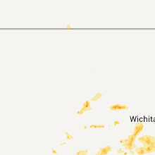


Cities Most Affected by Hail Storms of 8/3/2011
| Hail Size | Demographics of Zip Codes Affected | ||||||
|---|---|---|---|---|---|---|---|
| City | Count | Average | Largest | Pop Density | House Value | Income | Age |
| Geuda Springs, KS | 1 | 1.75 | 1.75 | 5 | $41k | $39.4k | 42.5 |
| Oklahoma City, OK | 1 | 1.75 | 1.75 | 3487 | $51k | $28.9k | 32.5 |
| Cotopaxi, CO | 1 | 1.75 | 1.75 | 4 | $112k | $34.6k | 55.0 |
| Arkansas City, KS | 1 | 1.75 | 1.75 | 106 | $48k | $31.3k | 36.8 |
Hail and Wind Damage Spotted on 8/3/2011
Filter by Report Type:Hail ReportsWind Reports
States Impacted
Kentucky, Indiana, Ohio, Tennessee, Montana, Oklahoma, Arkansas, New Mexico, Texas, Utah, Colorado, Missouri, Idaho, Kansas, Arizona, North Carolina, AlabamaKentucky
| Local Time | Report Details |
|---|---|
| 12:01 PM UTC | Multiple trees down in boone county KY, 10.8 miles WSW of Cincinnati, OH |
| 12:02 PM UTC | Large branches down in boone county KY, 13 miles WSW of Cincinnati, OH |
| 1:35 PM UTC | Delayed report of trees down on hawkins-cummins... brentsville... and bethlehem roads in bourbon county KY, 40.7 miles NNW of Irvine, KY |
| 1:40 PM UTC | Two trees down along jonesville roa in owen county KY, 37.8 miles SSW of Cincinnati, OH |
| 1:43 PM UTC | Three trees down on price rd.... cheryl lane... and glendover r in fayette county KY, 35.4 miles NW of Irvine, KY |
| 1:44 PM UTC | Three-quarter inch branches reported down near the intersection of richmond rd. and man o war blvd... estimates 60 mph winds in fayette county KY, 35.4 miles NW of Irvine, KY |
| 1:45 PM UTC | Three trees down near ash st. and georgetown s in fayette county KY, 35.4 miles NW of Irvine, KY |
| 1:49 PM UTC | Trees down on duvall station r in scott county KY, 53 miles NW of Irvine, KY |
| 1:54 PM UTC | Trees down on cane run road in scott county KY, 48.4 miles NW of Irvine, KY |
| 1:58 PM UTC | Tree fell across power line in powell county KY, 12.4 miles N of Irvine, KY |
| 2:00 PM UTC | Trees down on maple ave.... kentucky 29... short shun rd.... and keene r in jessamine county KY, 35.4 miles WNW of Irvine, KY |
| 2:03 PM UTC | One tree dow in madison county KY, 26.5 miles WNW of Irvine, KY |
| 2:17 PM UTC | One tree dow in madison county KY, 21.2 miles WSW of Irvine, KY |
| 12:45 AM UTC | Small trees and some large tree limbs down across fulton county. time estimate in fulton county KY, 47.6 miles NW of Mc Kenzie, TN |
| 1:00 AM UTC | Public reported that winds around 60 mph occurred near clinton. they also reported one large tree down. time estimate in hickman county KY, 45.1 miles NW of Mc Kenzie, TN |
Indiana
| Local Time | Report Details |
|---|---|
| 12:30 PM UTC | Tree down on 450 n and kenny r in ripley county IN, 43.9 miles W of Cincinnati, OH |
Ohio
| Local Time | Report Details |
|---|---|
| 1:25 PM UTC | I treee down in brown county OH, 49.8 miles SE of Cincinnati, OH |
| 1:30 PM UTC | 1 trree down in adams county OH, 56.1 miles ESE of Cincinnati, OH |
Tennessee
| Local Time | Report Details |
|---|---|
| 6:06 PM UTC | Dispatch reported trees down in the elgin are in scott county TN, 46.2 miles NW of Knoxville, TN |
| 6:06 PM UTC | Dispatch reported trees down in the robbins area on railroad t in scott county TN, 44.7 miles NW of Knoxville, TN |
| 6:42 PM UTC | Spotter reported a roof blown off of a storage building and numerous trees and power lines down near wartburg on knoxville highwa in morgan county TN, 37.6 miles WNW of Knoxville, TN |
| 6:48 PM UTC | Dispatch reported numerous trees down in the wartburg area on potters falls in morgan county TN, 38.7 miles WNW of Knoxville, TN |
| 11:20 PM UTC | Trees blown down on new hope road northwest of celina in clay county TN, 74.2 miles ENE of Nashville, TN |
| 11:20 PM UTC | Quarter sized hail reported near Lascassas, TN, 31.9 miles ESE of Nashville, TN, quarter size hail reported in lascassas by public via facebook |
| 12:45 AM UTC | Tree blown down on parchcorn hollow road in cannon county TN, 50.5 miles ESE of Nashville, TN |
| 12:55 AM UTC | Quarter sized hail reported near Woodbury, TN, 46.4 miles ESE of Nashville, TN, spotter in woodbury reported quarter size hail. |
| 1:40 AM UTC | 2 trees blown down on coop roa in bedford county TN, 43 miles SSE of Nashville, TN |
| 8:40 PM CDT | Quarter sized hail reported near Rockvale, TN, 31.4 miles SSE of Nashville, TN, quarter size hail reported near rockvale via facebook |
| 1:55 AM UTC | Tree blown down on highway 70 in putnam county TN, 74.7 miles N of Chattanooga, TN |
| 2:00 AM UTC | Several hundred acres of corn flattened near the intersection of highways 190 and 54 near the town of com in henry county TN, 10.9 miles N of Mc Kenzie, TN |
| 2:22 AM UTC | Small trees and several tree limbs down in paris proper. winds measured at 45 to 50mp in henry county TN, 16.4 miles NE of Mc Kenzie, TN |
| 2:22 AM UTC | Multiple power poles down along hwy 79 south of pari in henry county TN, 15.1 miles NE of Mc Kenzie, TN |
| 2:28 AM UTC | Roof blown off sawmill in henr in henry county TN, 7.7 miles NE of Mc Kenzie, TN |
| 2:34 AM UTC | Nws storm survey investigated damage along coal bank road near the derossett community. several large trees were snapped and uprooted and numerous large limbs were brok in white county TN, 60.9 miles N of Chattanooga, TN |
| 10:00 PM CDT | Tree blown down on power lines near chapel hil in marshall county TN, 37.3 miles S of Nashville, TN |
| 3:00 AM UTC | Trees and power lines blown down in unionville in bedford county TN, 39.2 miles SSE of Nashville, TN |
| 3:05 AM UTC | Trees down on cars and wall of building blown down in bedford county TN, 49.6 miles SSE of Nashville, TN |
| 3:15 AM UTC | Several trees down in rockwood and kingsto in roane county TN, 43 miles W of Knoxville, TN |
| 3:30 AM UTC | Emergency mngr reports multiple trees down...power lines down...and roof damage along swan ave near park ave nort in lewis county TN, 52.1 miles N of Florence, AL |
| 3:35 AM UTC | Trees blown down on moss branch roa in hickman county TN, 36.4 miles WSW of Nashville, TN |
| 3:35 AM UTC | Trees and powers lines down on hwy 31a between henry horton state park and lewisbur in marshall county TN, 45.4 miles S of Nashville, TN |
| 3:45 AM UTC | Dispatch reported trees down at the intersection of north shore drive and bluegrass road and on campbell station road near farragu in knox county TN, 15.4 miles WSW of Knoxville, TN |
| 3:45 AM UTC | Patial roof loss to a church gymnasium from downburst/outflow winds. time estimate in decatur county TN, 41.8 miles SE of Mc Kenzie, TN |
| 3:45 AM UTC | One set of powerlines down on northshor in knox county TN, 11.4 miles WSW of Knoxville, TN |
| 3:50 AM UTC | Dispatch reported a tree down at the intersection of westland drive and sherwood drive near knoxvill in knox county TN, 3.6 miles WSW of Knoxville, TN |
| 3:52 AM UTC | Trees blown down on hwy 64 just west of lawrenceburg. one tree down on automobile with driver trapped insid in lawrence county TN, 37.8 miles NNE of Florence, AL |
| 3:55 AM UTC | Several trees down across the northern part of the county in monroe county TN, 39.1 miles SW of Knoxville, TN |
| 4:00 AM UTC | One set of powerlines down on topside r in blount county TN, 7.1 miles SSW of Knoxville, TN |
| 4:05 AM UTC | Power company reported a large tree down on power lines on high school road near knoxvill in knox county TN, 4.8 miles NW of Knoxville, TN |
| 4:20 AM UTC | Dispatch reported a fallen tree blocking both lanes on mill springs road and power lines knocked down in jefferson cit in jefferson county TN, 25 miles ENE of Knoxville, TN |
| 4:20 AM UTC | Trees blown down on powell chapel road at highway 31 in giles county TN, 49.3 miles NE of Florence, AL |
| 4:23 AM UTC | Approximately 100 trees down throughout giles count in giles county TN, 49.3 miles NE of Florence, AL |
| 4:42 AM UTC | Trees reported down on several roads including shannon rd. and 2nd creek r in lawrence county TN, 26.7 miles NE of Florence, AL |
| 5:30 AM UTC | Numerous reports of trees and power lines down in lincoln county. several streets include oak street... clay street...lewisburg hwy...kidd rd...north main street...thor in lincoln county TN, 67.7 miles ENE of Florence, AL |
| 7:25 AM UTC | Several trees reported down in the bon air communit in white county TN, 61 miles N of Chattanooga, TN |
| 10:10 AM UTC | 911 relayed report of trees down and power lines down in the clifton are in wayne county TN, 43.7 miles NNW of Florence, AL |
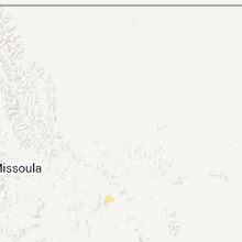
Montana
| Local Time | Report Details |
|---|---|
| 7:29 PM UTC | Quarter sized hail reported near Clancy, MT, 71.5 miles NW of Bozeman, MT, hail one inch in diameter with no rain at the time. |
| 7:32 PM UTC | Quarter sized hail reported near Clancy, MT, 71.5 miles NW of Bozeman, MT, hail to one inch in diameter ended. total rainfall of 0.15 inches. |
Oklahoma
| Local Time | Report Details |
|---|---|
| 8:25 PM UTC | Estimated 50-60 mph gusts in caddo county OK, 66.2 miles WSW of Oklahoma City, OK |
| 9:01 PM UTC | Quarter sized hail reported near Calumet, OK, 35.9 miles W of Oklahoma City, OK |
| 9:12 PM UTC | Quarter sized hail reported near Calumet, OK, 35.1 miles WNW of Oklahoma City, OK, relayed by the nssl shave project. |
| 9:35 PM UTC | The city of oklahoma and local broadcast media report building damage near and around stockyard city. several buildings sustained roof damage. much of the damage was th in oklahoma county OK, 1.9 miles SW of Oklahoma City, OK |
| 9:37 PM UTC | Quarter sized hail reported near Oklahoma City, OK, 5.6 miles W of Oklahoma City, OK, the hail was reported at reno and macarthur |
| 9:42 PM UTC | Quarter sized hail reported near Oklahoma City, OK, 3.4 miles W of Oklahoma City, OK, the hail was reported at nw 3rd and portland. |
| 9:45 PM UTC | Local broadcast media have reported building damage near the stockyards near exchange and agnew avenues. a semi was also blown over near this location. additional damag in oklahoma county OK, 1.9 miles SW of Oklahoma City, OK |
| 9:45 PM UTC | 2 inch branches down...delayed report in blaine county OK, 48.4 miles WNW of Oklahoma City, OK |
| 4:46 PM CDT | Golf Ball sized hail reported near Oklahoma City, OK, 4.5 miles W of Oklahoma City, OK |
| 9:50 PM UTC | Quarter sized hail reported near Oklahoma City, OK, 3.4 miles NW of Oklahoma City, OK, reported near nw 20th and portland avenue. |
| 9:50 PM UTC | Half Dollar sized hail reported near Oklahoma City, OK, 4.4 miles WNW of Oklahoma City, OK, relayed by the nssl shave project. |
| 5:00 PM CDT | Storm damage reported in noble county OK, 65.3 miles WNW of Tulsa, OK |
| 11:13 PM UTC | Quarter sized hail reported near Enid, OK, 63.5 miles NNW of Oklahoma City, OK |
| 11:20 PM UTC | 55-65 mph winds. some tree damag in osage county OK, 35.9 miles NNW of Tulsa, OK |
| 11:28 PM UTC | Power poles down in dewey county OK, 21.7 miles SSE of Woodward, OK |
| 11:28 PM UTC | Quarter sized hail reported near Vici, OK, 21.7 miles SSE of Woodward, OK |
| 11:30 PM UTC | Storm damage reported in woodward county OK, 1.5 miles SW of Woodward, OK |
| 11:44 PM UTC | Several large trees blown down at entrance to woolaroc. other tree damage around area. damage to several sheds. reported by grounds manage in osage county OK, 40.3 miles NNW of Tulsa, OK |
| 11:45 PM UTC | Numerous large limbs broken in tow in osage county OK, 39.4 miles N of Tulsa, OK |
| 11:53 PM UTC | Corrected lsr for location... pea size hail was also reporte in woodward county OK, 11.7 miles E of Woodward, OK |
| 11:53 PM UTC | Pea size hail was also reporte in woodward county OK, 11.7 miles E of Woodward, OK |
| 12:01 AM UTC | Pea sized hail also reported in woodward county OK, 12.8 miles E of Woodward, OK |
| 12:20 AM UTC | Measured at the may ranch mesonet sit in woods county OK, 43.7 miles NNE of Woodward, OK |
| 12:25 AM UTC | Measured at the may ranch mesonet sit in woods county OK, 43.7 miles NNE of Woodward, OK |
| 12:25 AM UTC | Storm damage reported in woods county OK, 43.7 miles NNE of Woodward, OK |
| 12:33 AM UTC | Storm damage reported in woods county OK, 46.7 miles ENE of Woodward, OK |
| 12:35 AM UTC | Measured at the may ranch mesonet sit in woods county OK, 43.7 miles NNE of Woodward, OK |
Arkansas
| Local Time | Report Details |
|---|---|
| 8:25 PM UTC | Damage occurred in the 800 and 900 blocks of arkansas 124 about 1.5 miles west of quitman. eight houses had roof damage. eight sheds...three barns...and two shop buildi in cleburne county AR, 43.6 miles N of Little Rock, AR |
| 9:00 PM UTC | Trees and power lines were blown down along the pulaski/saline county line in the shannon hills are in pulaski county AR, 10.4 miles S of Little Rock, AR |
| 9:02 PM UTC | Thunderstorm winds blew off part of roof of a home and dime size hail was also reporte in white county AR, 37.9 miles NNE of Little Rock, AR |
| 9:30 PM UTC | Thunderstorm winds damaged several homes and toppled large trees. two 18 wheel trucks blown onto side on i40 just sw of the center of clarksville. wind speed estimated in johnson county AR, 53.9 miles E of Fort Smith, AR |
| 11:15 PM UTC | Public reported that major roof damage to structures occured including roofing being peeled off of houses and sheds. several sheds were lifted off their foundation and in sharp county AR, 102.1 miles NNE of Little Rock, AR |
| 8:37 AM UTC | Trees and power poles were down. some trees had to be cut out of the roa in woodruff county AR, 65.3 miles W of Memphis, TN |
| 9:10 AM UTC | Wind damage reported in rivercrest area. broken tree limbs. boat dock overturned onto the shore. time approximat in crawford county AR, 4 miles E of Fort Smith, AR |
New Mexico
| Local Time | Report Details |
|---|---|
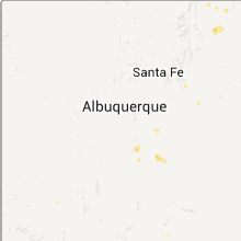
| 9:14 PM UTC | White sands missile range - stallion runwa in socorro county NM, 87.1 miles S of Albuquerque, NM |
| 10:00 PM UTC | Quarter sized hail reported near Albuquerque, NM, 9.6 miles NE of Albuquerque, NM |
Texas
| Local Time | Report Details |
|---|---|
| 9:45 PM UTC | 80 to 90 mph microburst wind damage. damaged outbuildings... carports... fences... overhead garage door... construction framin in potter county TX, 6.9 miles NE of Amarillo, TX |
Utah
| Local Time | Report Details |
|---|---|
| 9:53 PM UTC | Storm damage reported in grand county UT, 67.6 miles WSW of Grand Junction, CO |
Colorado
| Local Time | Report Details |
|---|---|
| 10:17 PM UTC | Quarter sized hail reported near Cotopaxi, CO, 48.5 miles W of Pueblo, CO |
| 10:25 PM UTC | Golf Ball sized hail reported near Cotopaxi, CO, 50.6 miles W of Pueblo, CO |
Missouri
| Local Time | Report Details |
|---|---|
| 10:30 PM UTC | Delayed report--television station weather spotter reported tree damage and small hail. time estimated from rada in ozark county MO, 60.2 miles SE of Springfield, MO |
| 12:00 AM UTC | Quarter sized hail reported near Poplar Bluff, MO, 60.7 miles SW of Cape Girardeau, MO |
| 8:20 AM UTC | Knvd awos measured a 51 knot or 59 mph wind gus in vernon county MO, 61.3 miles E of Chanute, KS |
| 9:28 AM UTC | Storm spotter reported 60 mph wind gus in hickory county MO, 44.5 miles N of Springfield, MO |
| 9:30 AM UTC | Media relayed public report of a large tree down on a hous in hickory county MO, 53 miles N of Springfield, MO |
| 11:06 AM UTC | Tree down on hwy v one mile south of hwy 5 in camden county MO, 65.6 miles NNE of Springfield, MO |
Idaho
| Local Time | Report Details |
|---|---|
| 10:38 PM UTC | Thunderstorm west of hollister collapsed and produced an outflow boundary that was strongest to its east with a peak gust to 58 mph at trail gulch raws in the hour endi in twin falls county ID, 18.6 miles SSE of Twin Falls, ID |
Kansas
| Local Time | Report Details |
|---|---|
| 11:23 PM UTC | Storm damage reported in pratt county KS, 77 miles W of Wichita, KS |
| 11:26 PM UTC | Power poles down at the intersection of highway 281 and 30th street. additional power poles down within the city of prat in pratt county KS, 77 miles W of Wichita, KS |
| 11:28 PM UTC | Shingles were torn off the roof of a house and a 2 inch diameter tree limb was blown dow in pratt county KS, 77 miles W of Wichita, KS |
| 11:50 PM UTC | Quarter sized hail reported near Pratt, KS, 66.6 miles W of Wichita, KS |
| 12:20 AM UTC | Large limb downe in reno county KS, 52.1 miles NW of Wichita, KS |
| 12:50 AM UTC | Quarter sized hail reported near Harper, KS, 47.4 miles SW of Wichita, KS, small limbs downed. power outage. |
| 1:13 AM UTC | Storm damage reported in reno county KS, 46.7 miles W of Wichita, KS |
| 1:15 AM UTC | Lawn furniture and bbq grill were blown across yar in barber county KS, 70.8 miles NE of Woodward, OK |
| 1:17 AM UTC | Signs blown down. other unspecified damage reporte in reno county KS, 50 miles W of Wichita, KS |
| 1:17 AM UTC | Signs blown over. further...unspecified damage reporte in reno county KS, 50 miles W of Wichita, KS |
| 1:30 AM UTC | One inch diameter limbs downed 5 miles west of k-14 and 4 miles north of reno/kingman county lin in reno county KS, 57.3 miles W of Wichita, KS |
| 1:32 AM UTC | Storm damage reported in barber county KS, 73.7 miles WSW of Wichita, KS |
| 2:18 AM UTC | At least 60 mph in mila in sumner county KS, 34.7 miles SSW of Wichita, KS |
| 2:18 AM UTC | Power outages along tyler road from kellogg through maple to central avenu in sedgwick county KS, 6.8 miles W of Wichita, KS |
| 2:20 AM UTC | Power outage east of turnpike in haysvill in sedgwick county KS, 8.1 miles S of Wichita, KS |
| 2:21 AM UTC | Power outages at north of pawnee between hydraulic and washington street in sedgwick county KS, 0.3 miles NW of Wichita, KS |
| 2:22 AM UTC | Power poles downed. power outages reported across southern third of sumner count in sumner county KS, 26.4 miles SW of Wichita, KS |
| 2:33 AM UTC | Gusts ranged from 50-60 mph 8 miles northwest of conway spring in sumner county KS, 28.5 miles WSW of Wichita, KS |
| 2:40 AM UTC | Ranged from 60-70 mph at wfo wichit in sedgwick county KS, 13.9 miles W of Wichita, KS |
| 2:45 AM UTC | Ranged from 60-70 mp in sedgwick county KS, 6.8 miles W of Wichita, KS |
| 2:45 AM UTC | Numerous tree branches downed. a 10 inch diameter tree was snapped at the base. the wet microburst lasted from 945 pm to 1005 pm. the damage occurred at pawnee and sene in sedgwick county KS, 3.1 miles SW of Wichita, KS |
| 2:48 AM UTC | Consistently between 60 and 70 mp in sedgwick county KS, 6.8 miles W of Wichita, KS |
| 2:50 AM UTC | 6 inch diameter limbs downed. relayed by kake channel 1 in reno county KS, 21.2 miles WNW of Wichita, KS |
| 2:50 AM UTC | Golf Ball sized hail reported near Arkansas City, KS, 41.2 miles SSE of Wichita, KS, one half mile east of gueda springs. |
| 2:53 AM UTC | A large diameter mature tree was snapped at 47th and hydraulic. powerlines were downe in sedgwick county KS, 3.9 miles S of Wichita, KS |
| 2:55 AM UTC | Reported by off duty national weather service employee at 21st and maiz in sedgwick county KS, 6.8 miles W of Wichita, KS |
| 2:55 AM UTC | Occurred at i-135 south hydraulic interchang in sedgwick county KS, 6.2 miles SSE of Wichita, KS |
| 2:55 AM UTC | Ranged from 60-70 mph at central and ridg in sedgwick county KS, 6.8 miles W of Wichita, KS |
| 2:58 AM UTC | Reported by off duty nws employee at central and 119th stree in sedgwick county KS, 6.8 miles W of Wichita, KS |
| 3:00 AM UTC | Storm damage reported in sumner county KS, 41.1 miles SSE of Wichita, KS |
| 3:00 AM UTC | 8 to 9 inch diameter tree limbs were downed. siding was ripped off of an apartment building. damage occurred at pawnee and broadwa in sedgwick county KS, 3.3 miles S of Wichita, KS |
| 3:00 AM UTC | Construction fence was damaged at central and west street. roof damage reported at the plaza west shopping center at central and wes in sedgwick county KS, 3.5 miles W of Wichita, KS |
| 3:00 AM UTC | Golf Ball sized hail reported near Geuda Springs, KS, 41.1 miles SSE of Wichita, KS, golfball size hail was reported by the fire department. damage to windows was reported in the area. |
| 3:02 AM UTC | Jabarra airpor in sedgwick county KS, 7.7 miles NE of Wichita, KS |
| 3:05 AM UTC | Trained spotter reported 8 to 10 inch diameter tree limbs downed in his yard and estimated 70 to 80 mph wind gust in sedgwick county KS, 2.7 miles SE of Wichita, KS |
| 3:12 AM UTC | Jabarra airpor in sedgwick county KS, 7.7 miles NE of Wichita, KS |
| 3:17 AM UTC | Tree downed at maple and woodchuc in sedgwick county KS, 6.8 miles W of Wichita, KS |
| 3:17 AM UTC | 10-inch diamater limb downe in butler county KS, 18.7 miles ENE of Wichita, KS |
| 3:18 AM UTC | Power outages along tyler road from kellogg through maple to central avenu in sedgwick county KS, 6.8 miles W of Wichita, KS |
| 3:20 AM UTC | Power outage east of turnpike in haysvill in sedgwick county KS, 8.1 miles S of Wichita, KS |
| 3:21 AM UTC | Power outages at north of pawnee between hydraulic and washington street in sedgwick county KS, 0.3 miles NW of Wichita, KS |
| 3:25 AM UTC | Relayed through harvey county sherif in harvey county KS, 20.6 miles NNE of Wichita, KS |
| 3:27 AM UTC | Several tree limbs were reported downed from the newton area to several miles southeast of newto in harvey county KS, 24.3 miles N of Wichita, KS |
| 3:35 AM UTC | Shed lost part of roo in harvey county KS, 21.1 miles N of Wichita, KS |
| 3:35 AM UTC | Quarter sized hail reported near Winfield, KS, 35.1 miles SE of Wichita, KS, public report relayed by ksn pinpoint weather. |
| 3:38 AM UTC | Limbs downed at hydraulic/mccarther intersection. railroad crossing gates blown from crossing at k-15 and mccarthe in sedgwick county KS, 6.2 miles SSE of Wichita, KS |
Arizona
| Local Time | Report Details |
|---|---|
| 12:27 AM UTC | Storm damage reported in maricopa county AZ, 48.5 miles SW of Phoenix, AZ |
| 1:51 AM UTC | Large tree down near 303 and greenwa in maricopa county AZ, 23.5 miles WNW of Phoenix, AZ |
| 3:02 AM UTC | Report of 8 downed power poles on 59th ave between union hills and bell road in glendale. also...residential roof collapse and roof fire due to the downed lines along t in maricopa county AZ, 15.4 miles NNW of Phoenix, AZ |
North Carolina
| Local Time | Report Details |
|---|---|
| 3:20 AM UTC | At least a few trees down across graham county. first report was of a couple trees down on santeetlah road. a tree down on highway 143. a tree down on highway 29 but no in graham county NC, 42.3 miles S of Knoxville, TN |
| 3:35 AM UTC | One tree reported down in the nantahala gorg in swain county NC, 49.4 miles SSE of Knoxville, TN |
| 4:20 AM UTC | At least a few trees down across graham county. first report was of a couple trees down on santeetlah road. a tree down on highway 143. a tree down on highway 29 but no in graham county NC, 42.3 miles S of Knoxville, TN |
| 4:35 AM UTC | One tree reported down in the nantahala gorg in swain county NC, 49.4 miles SSE of Knoxville, TN |
| 4:35 AM UTC | Power company reported a tree had knocked down power lines at the intersection of morgan hill road and martins creek roa in cherokee county NC, 60.9 miles S of Knoxville, TN |
| 4:35 AM UTC | Power company reported that a tree had knocked down power lines at the intersection of morgan hill road and martins creek roa in cherokee county NC, 60.9 miles S of Knoxville, TN |
| 4:40 AM UTC | Power company reported a tree down on power lines near the pleasant valley communit in cherokee county NC, 58.2 miles S of Knoxville, TN |
| 4:50 AM UTC | Power company reported a tree knocked down power lines at the intersection of morgan hill road and martins creek roa in cherokee county NC, 60.9 miles S of Knoxville, TN |
Alabama
| Local Time | Report Details |
|---|---|
| 4:50 AM UTC | Gust estimated 1 mile west of wall triana and pine grove roads in harves in madison county AL, 52.8 miles E of Florence, AL |
| 4:50 AM UTC | Large pine tree down in the 600 block of pine grove road in harvest in madison county AL, 52.7 miles E of Florence, AL |
| 4:50 AM UTC | Numerous hardwood trees down. winds estimated at 70 mp in limestone county AL, 49.3 miles E of Florence, AL |
| 4:54 AM UTC | Storm damage reported in madison county AL, 52.8 miles E of Florence, AL |
| 5:00 AM UTC | Numerous power outages reported across madison count in madison county AL, 61.9 miles E of Florence, AL |
| 5:00 AM UTC | Large trees down off eastview rd in madison in madison county AL, 52.9 miles E of Florence, AL |
| 5:04 AM UTC | Storm damage reported in madison county AL, 52.4 miles E of Florence, AL |
| 5:10 AM UTC | Large tree blown down on windover avenue. time estimate in madison county AL, 61.9 miles E of Florence, AL |
| 5:15 AM UTC | Large tree down on carter road in harvest. a utility pole is leaning severely as well at the same locatio in madison county AL, 52.8 miles E of Florence, AL |
| 5:15 AM UTC | Power lines blown down in monrovia on knotts creek and balch roa in madison county AL, 52.8 miles E of Florence, AL |
| 5:15 AM UTC | Trampoline flew over a house and landed on a vehicle on banmalk drive in harvest. no injuries occurre in madison county AL, 52.8 miles E of Florence, AL |
| 5:18 AM UTC | Power line to dcu asos on ground with trees on top of lins. in addition...multiple trees on the road leading to the asos. in addition...small plane at the airport flipp in morgan county AL, 42.1 miles ESE of Florence, AL |
| 5:18 AM UTC | Power line to dcu asos on ground with trees on top of lines. in addition...multiple trees on the road leading to the asos. in addition...small plane at the airport flip in limestone county AL, 43 miles ESE of Florence, AL |
| 5:20 AM UTC | Numerous reports of wind damage across limestone county. lightning has also started several fires...and power is out to a large portion of the count in limestone county AL, 40.1 miles E of Florence, AL |
| 5:20 AM UTC | Tree down on nixon chapel roa in marshall county AL, 55.3 miles NNE of Birmingham, AL |
| 5:20 AM UTC | Tree down in zierdt road in triana in madison county AL, 55.2 miles ESE of Florence, AL |
| 5:55 AM UTC | 20 year old medium sized tree blown down on county road 1117 in west poin in cullman county AL, 50.3 miles N of Birmingham, AL |
| 6:00 AM UTC | Tree fell on a residence in blountsville. winds estimated between 35 and 50 mp in blount county AL, 42.1 miles NNE of Birmingham, AL |
| 6:00 AM UTC | Power outage along highway 431 in guntersville mainly near albertville city limi in marshall county AL, 65.2 miles NNE of Birmingham, AL |
| 6:38 AM UTC | Tree blocking floyd road in the beulah communit in marshall county AL, 64.2 miles WSW of Chattanooga, TN |
| 6:44 AM UTC | Tree down on robertson lane in the douglas communit in marshall county AL, 53 miles NNE of Birmingham, AL |
| 6:50 AM UTC | Numerous trees down in and around guntersville... including the warrenton community and on willow beach road between sunset and hwy 7 in marshall county AL, 65.2 miles NNE of Birmingham, AL |
| 7:02 AM UTC | Trees down on bishop mountain road in gran in marshall county AL, 64.2 miles WSW of Chattanooga, TN |
| 7:10 AM UTC | Several trees blown down in kilpatrick on the marshall-dekalb county lin in dekalb county AL, 66.6 miles NE of Birmingham, AL |
| 7:35 AM UTC | *** 1 fatal *** tree down on a mobile home on locust lane in the locust shores community. fatality occurred when woman was trapped beneath the tree within the mobile ho in colbert county AL, 8.2 miles SW of Florence, AL |
| 7:40 AM UTC | Trees down on vaughn bridge road in hartselle in morgan county AL, 48.7 miles ESE of Florence, AL |
| 7:54 AM UTC | Trees and branches down on mud tavern road at south chapel hill southwest of decatu in morgan county AL, 40.3 miles ESE of Florence, AL |
| 7:57 AM UTC | Tree down on a house on locust lane in the locust shores community. woman is trapped under the tree and the fire department is on the scene. possible injurie in colbert county AL, 8.2 miles SW of Florence, AL |
| 8:56 AM UTC | Several trees were reported down across the northeast portion of marion count in marion county AL, 42.1 miles S of Florence, AL |
| 9:10 AM UTC | Numerous trees were blown down across the count in winston county AL, 47.5 miles SSE of Florence, AL |
Connect with Interactive Hail Maps