

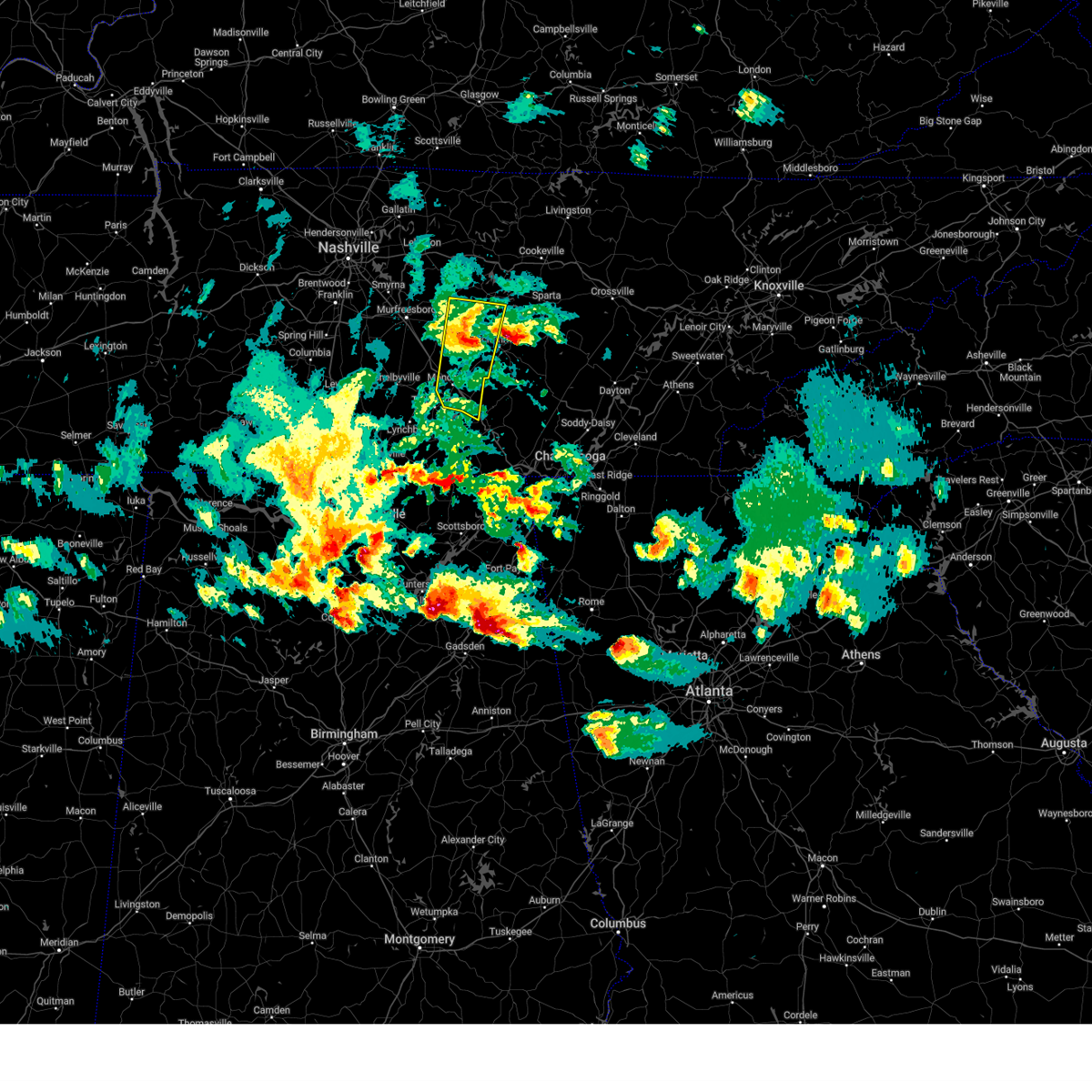
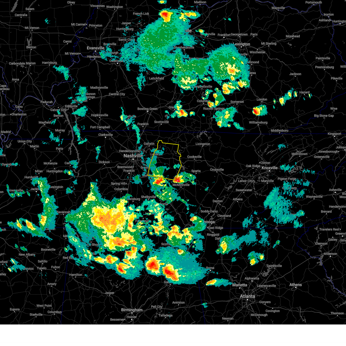
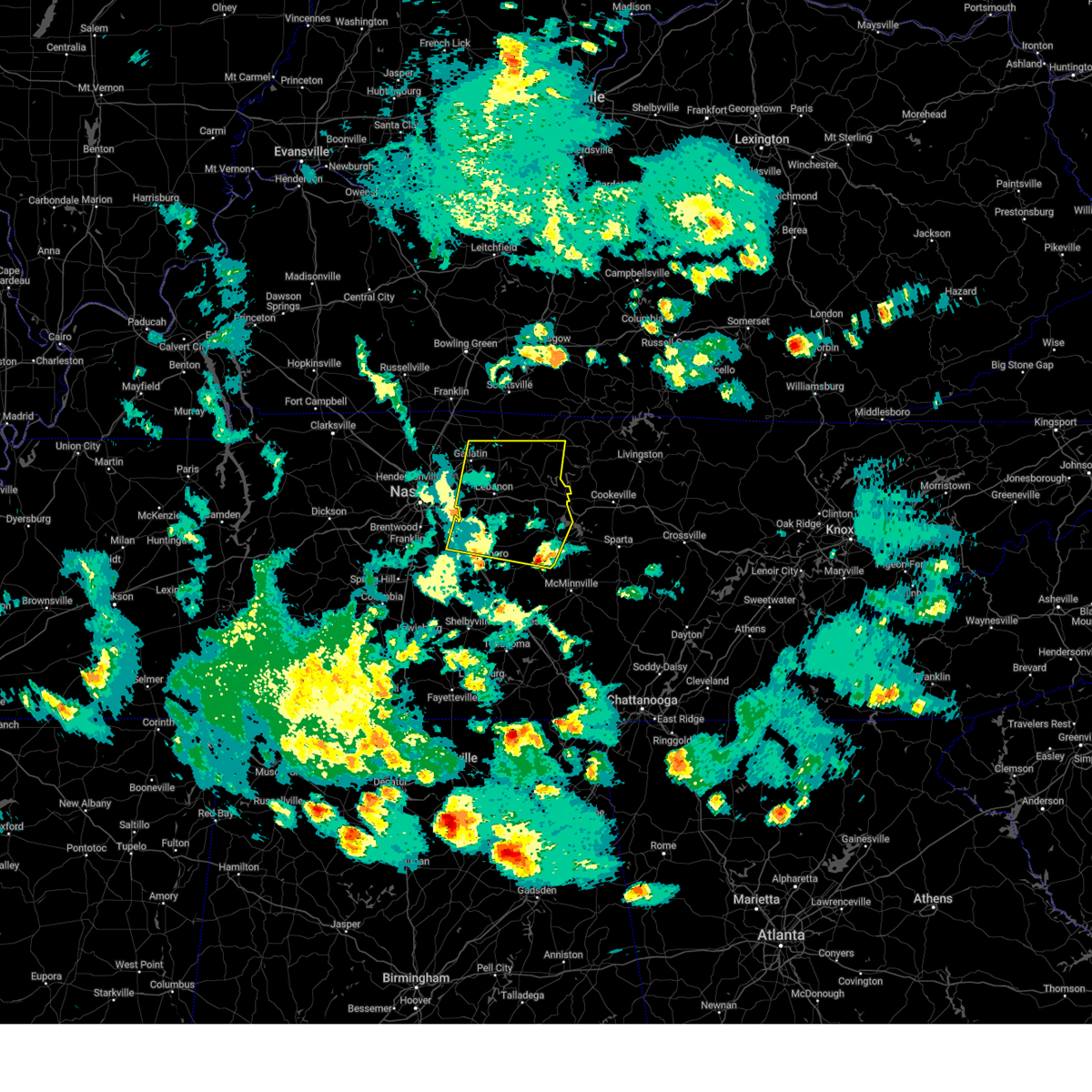
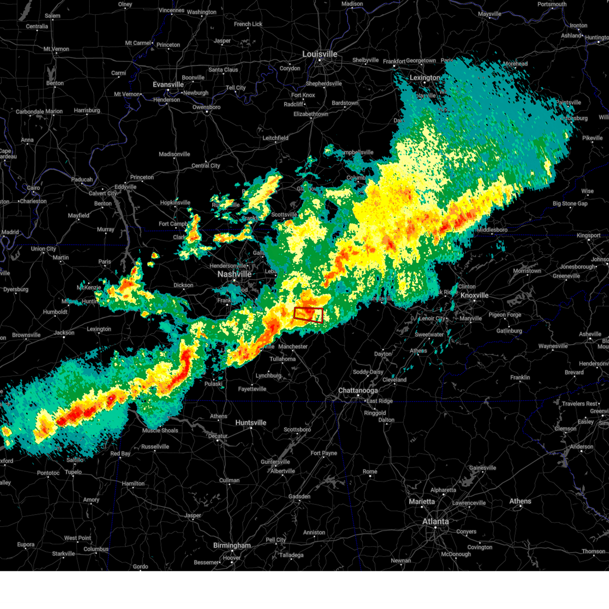
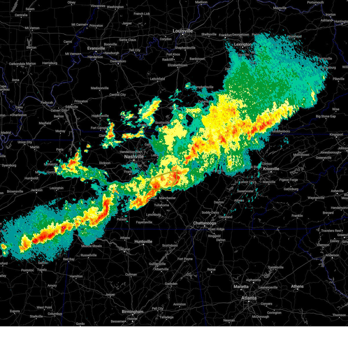
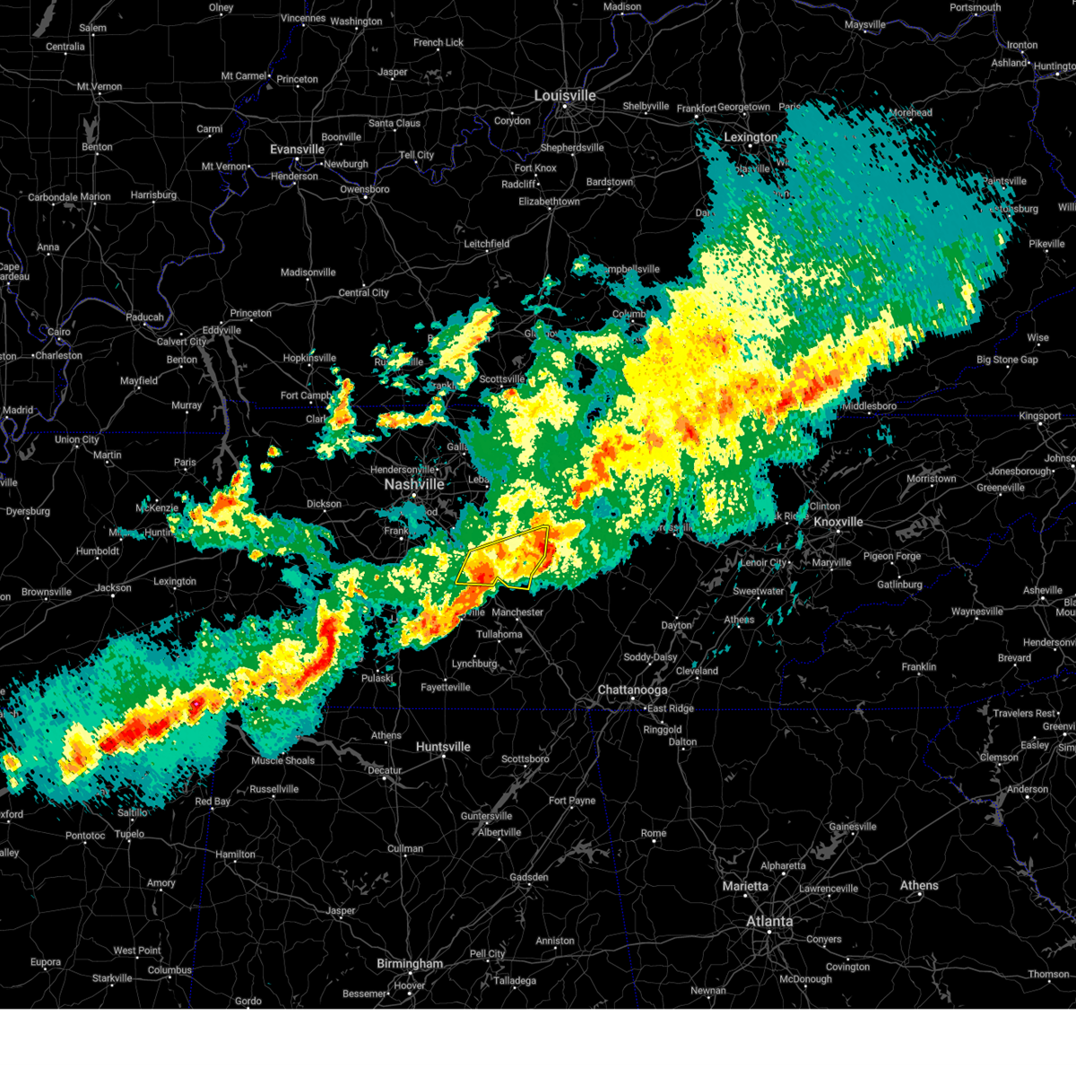
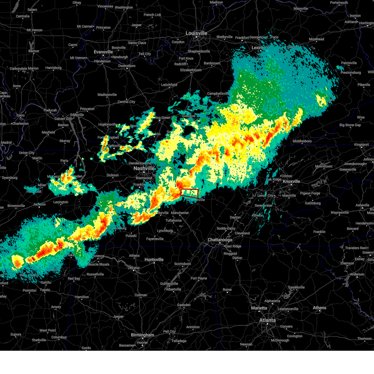
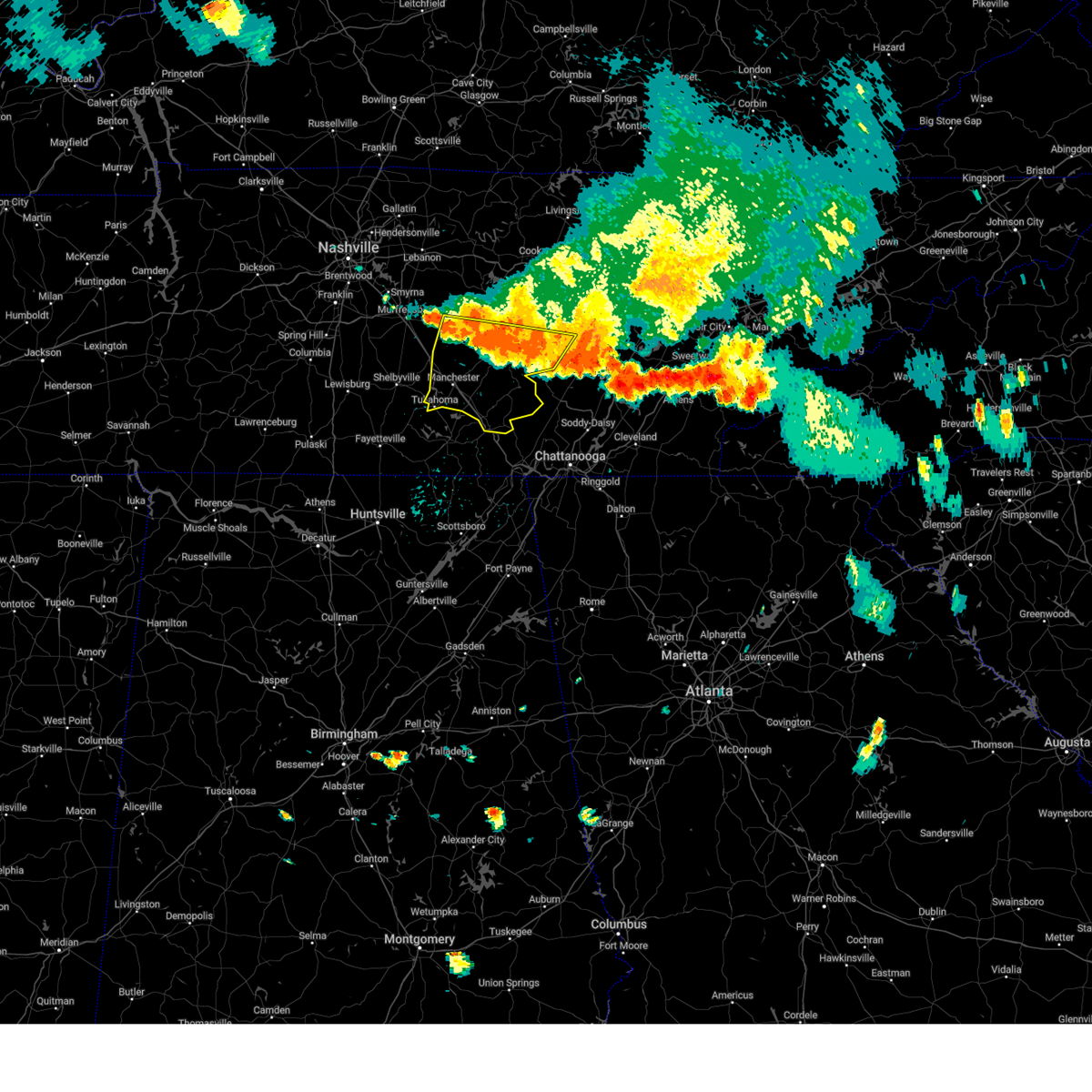
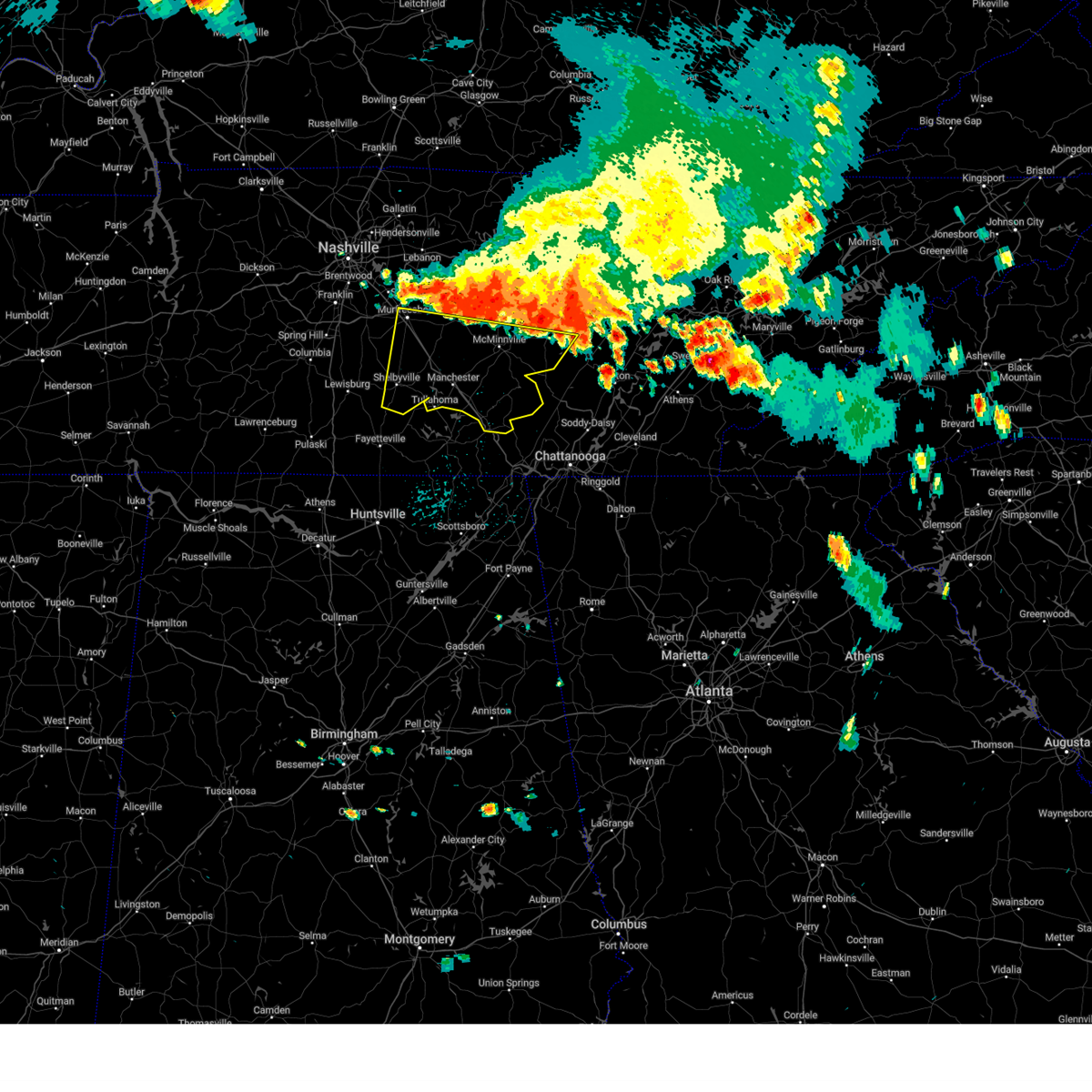
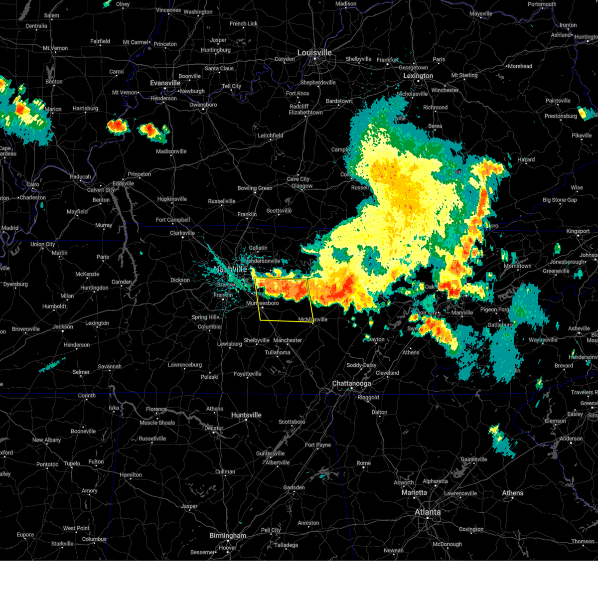
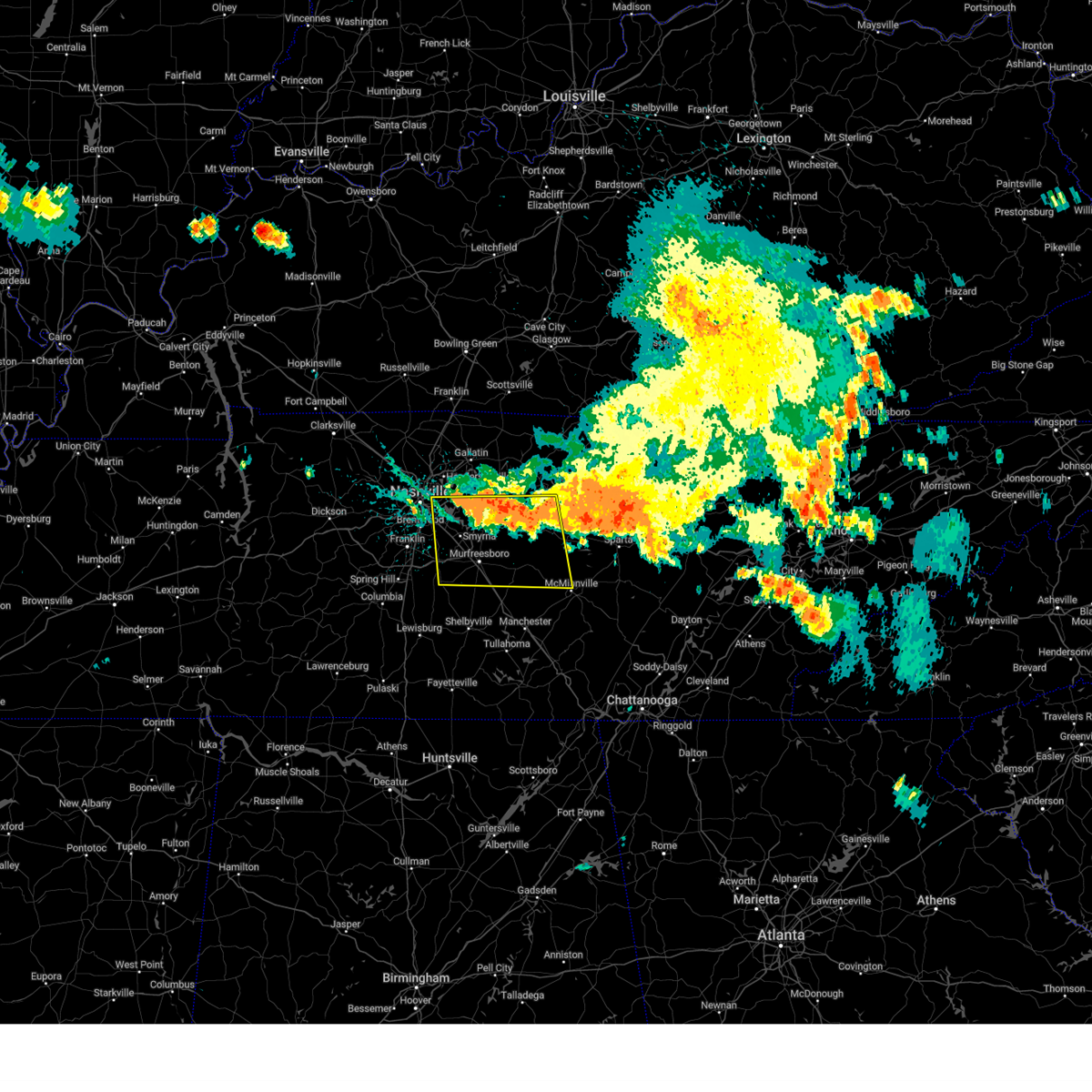
Hail Map for Woodbury, TN
The Woodbury, TN area has had 5 reports of on-the-ground hail by trained spotters, and has been under severe weather warnings 49 times during the past 12 months. Doppler radar has detected hail at or near Woodbury, TN on 51 occasions, including 6 occasions during the past year.
| Name: | Woodbury, TN |
| Where Located: | 46.2 miles ESE of Nashville, TN |
| Map: | Google Map for Woodbury, TN |
| Population: | 2680 |
| Housing Units: | 1219 |
| More Info: | Search Google for Woodbury, TN |
4
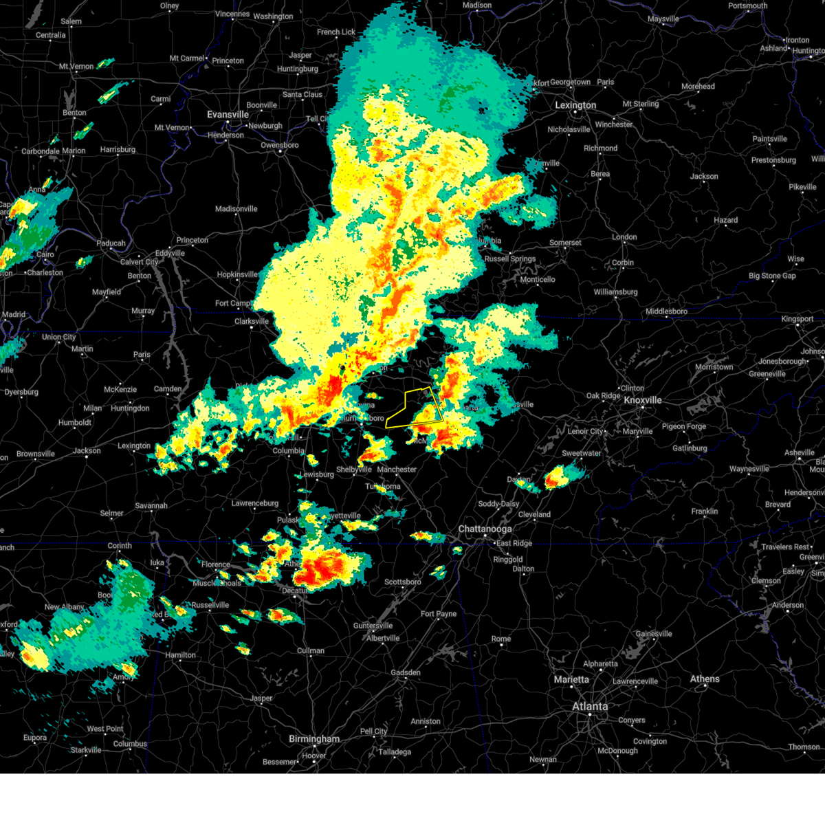
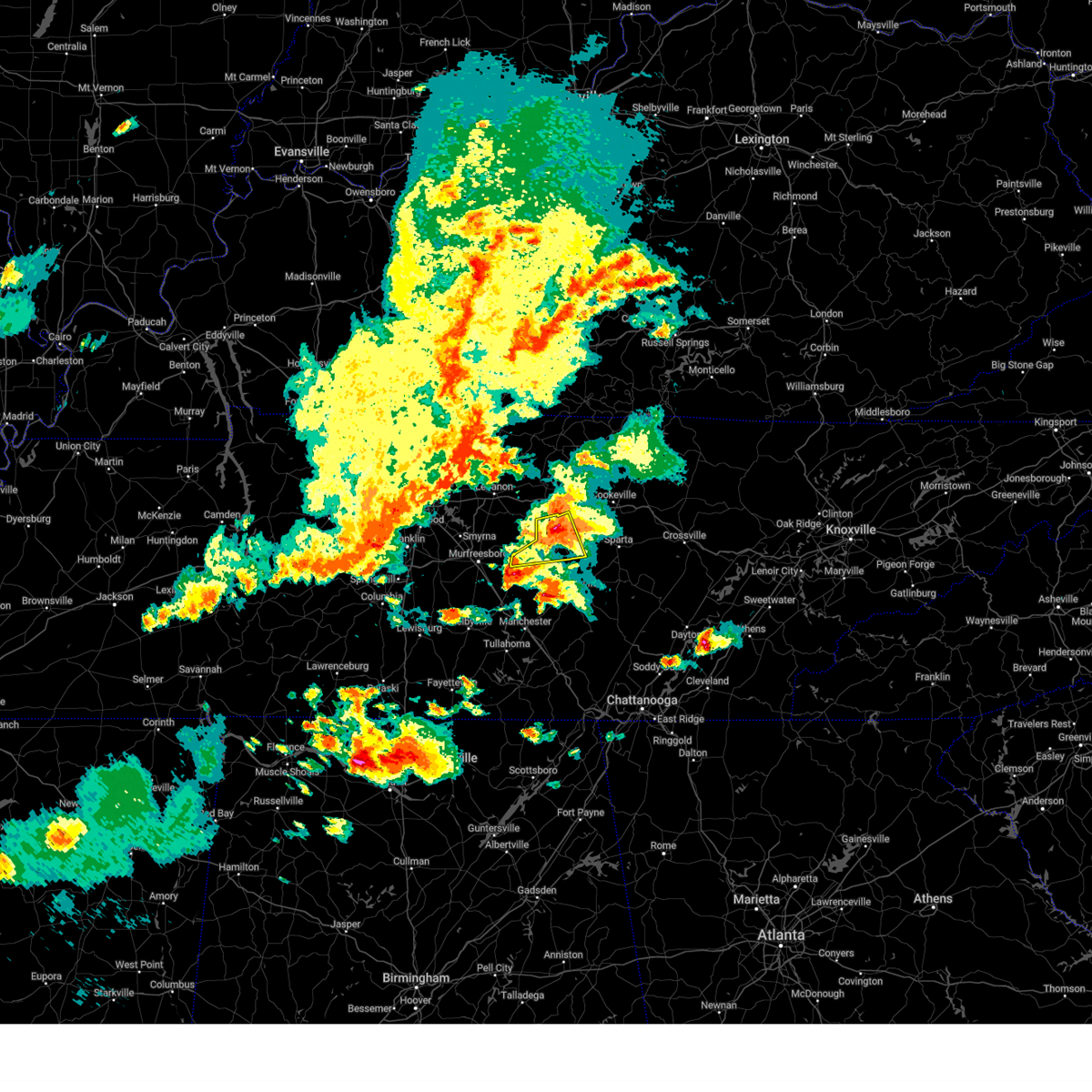
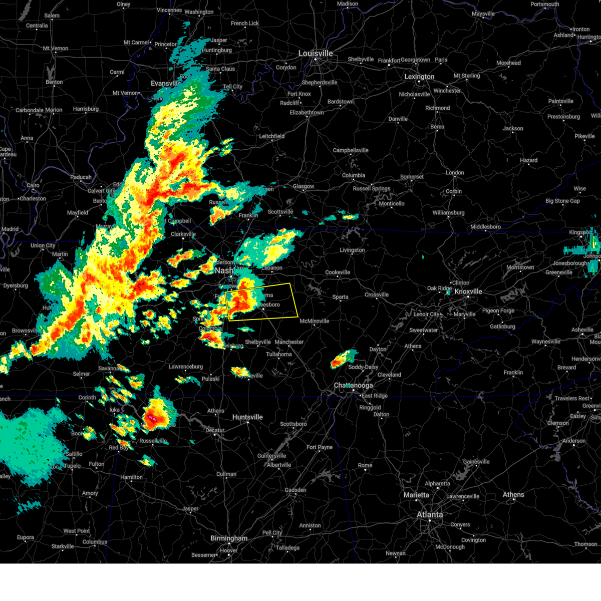
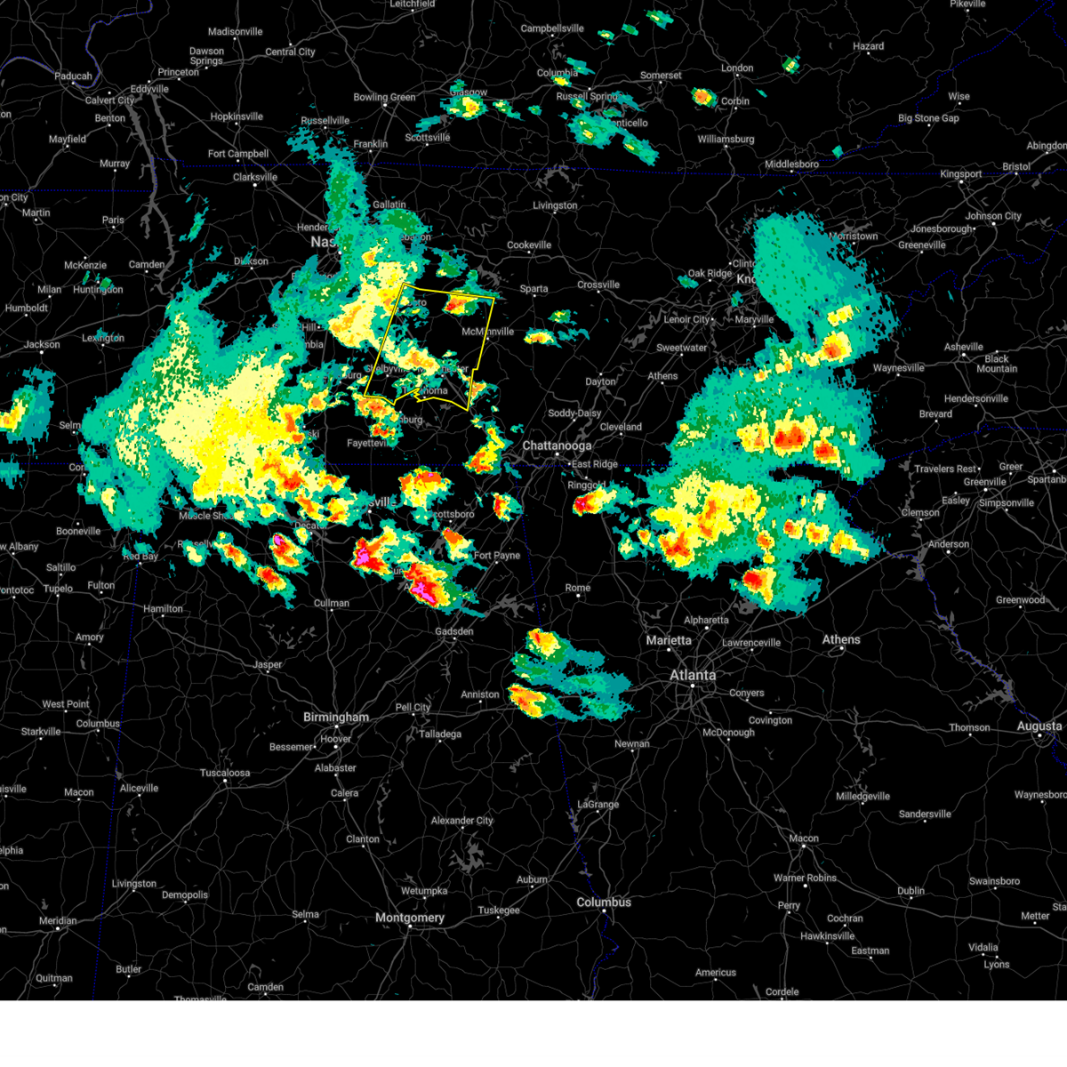
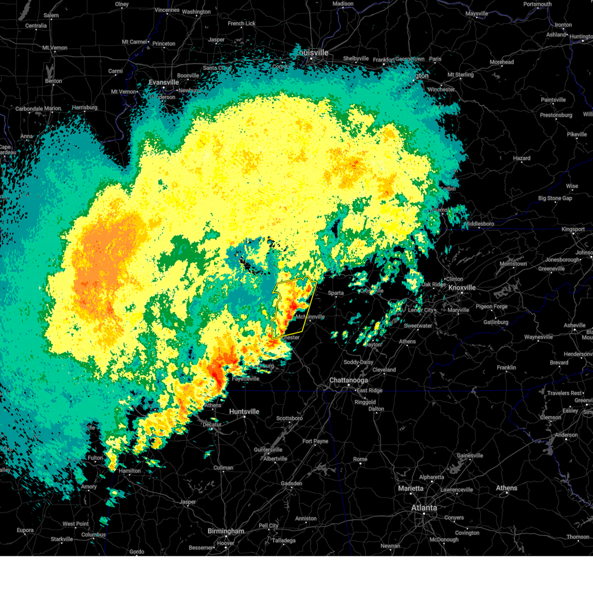
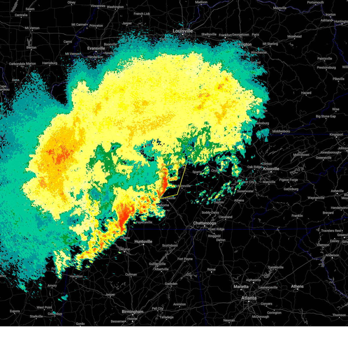
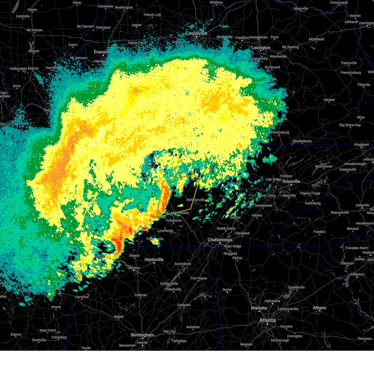
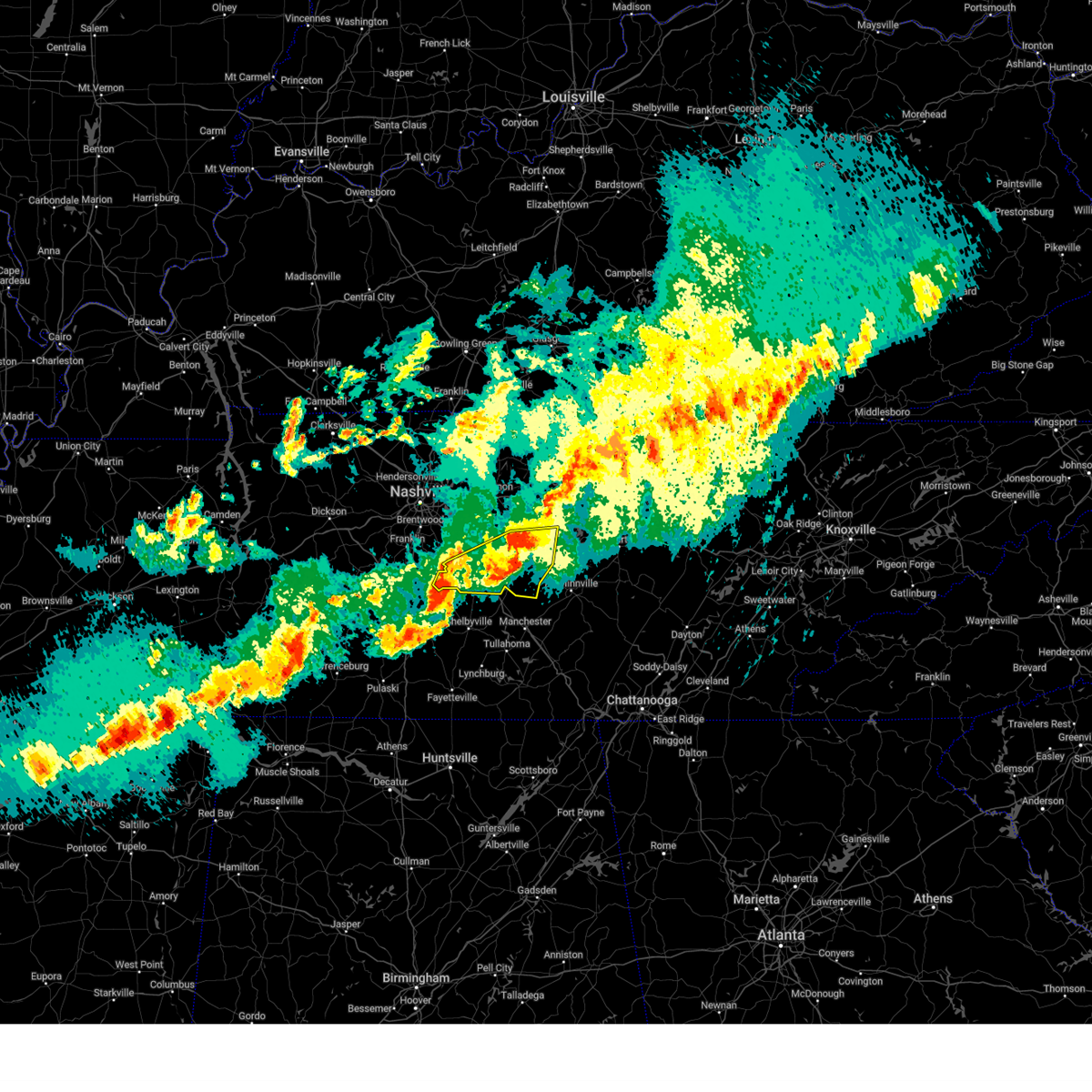
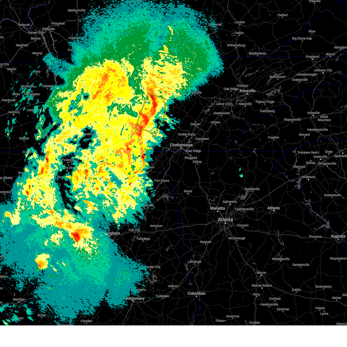
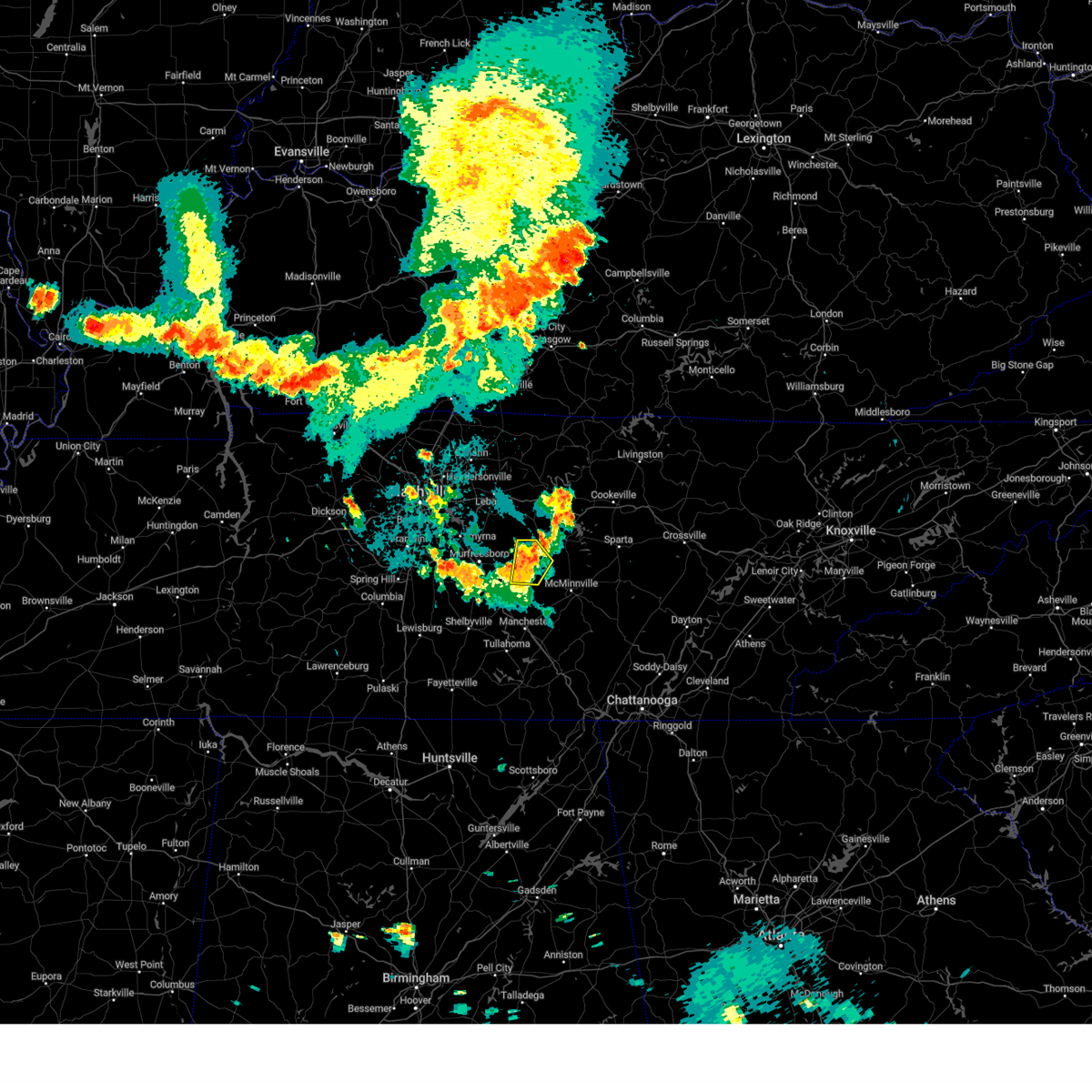
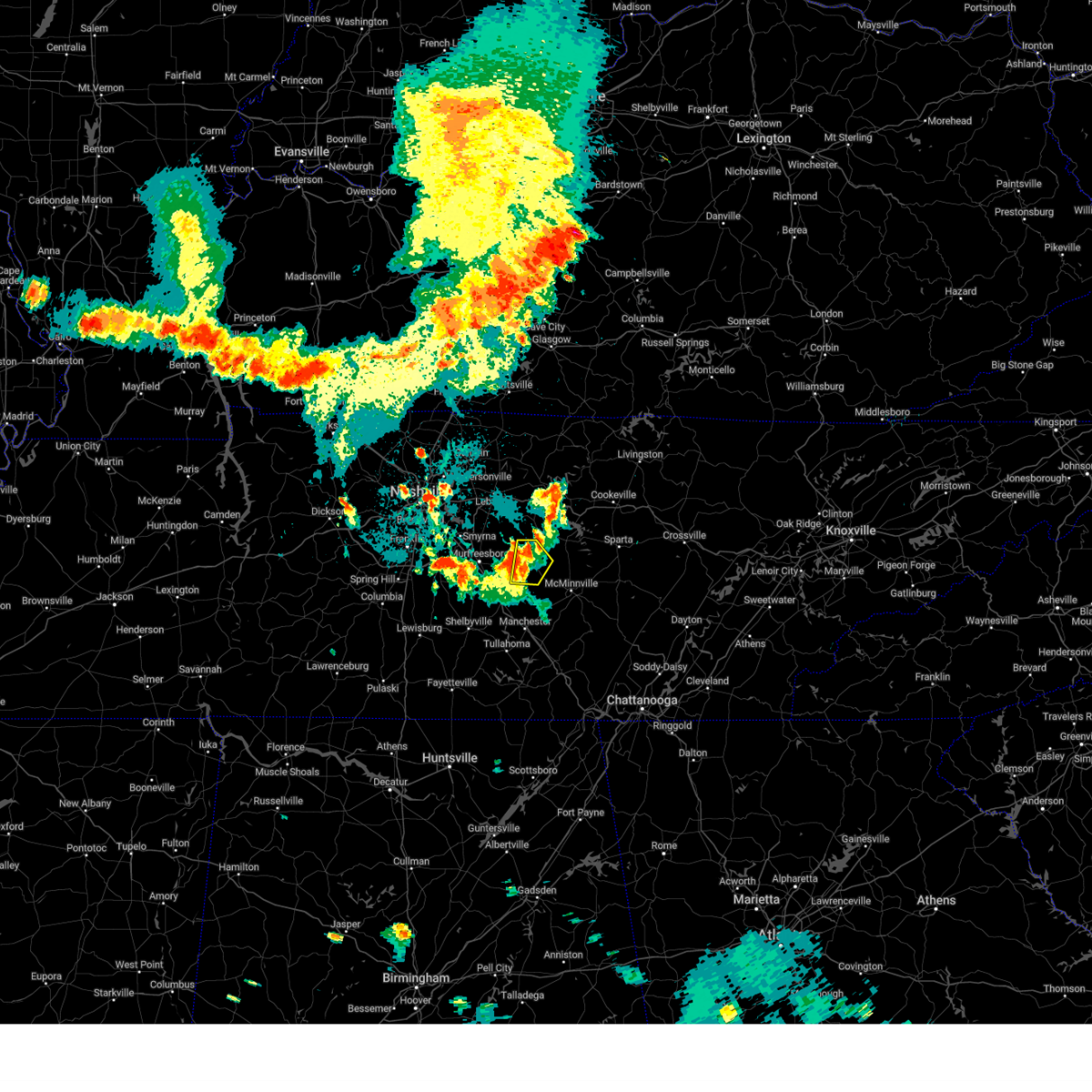
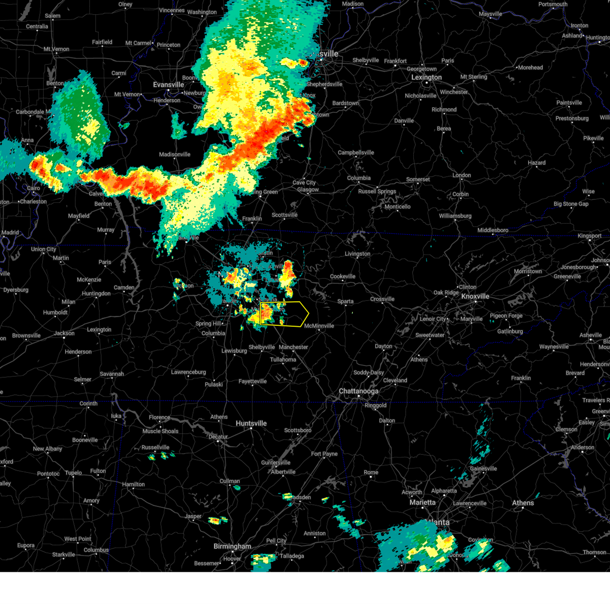
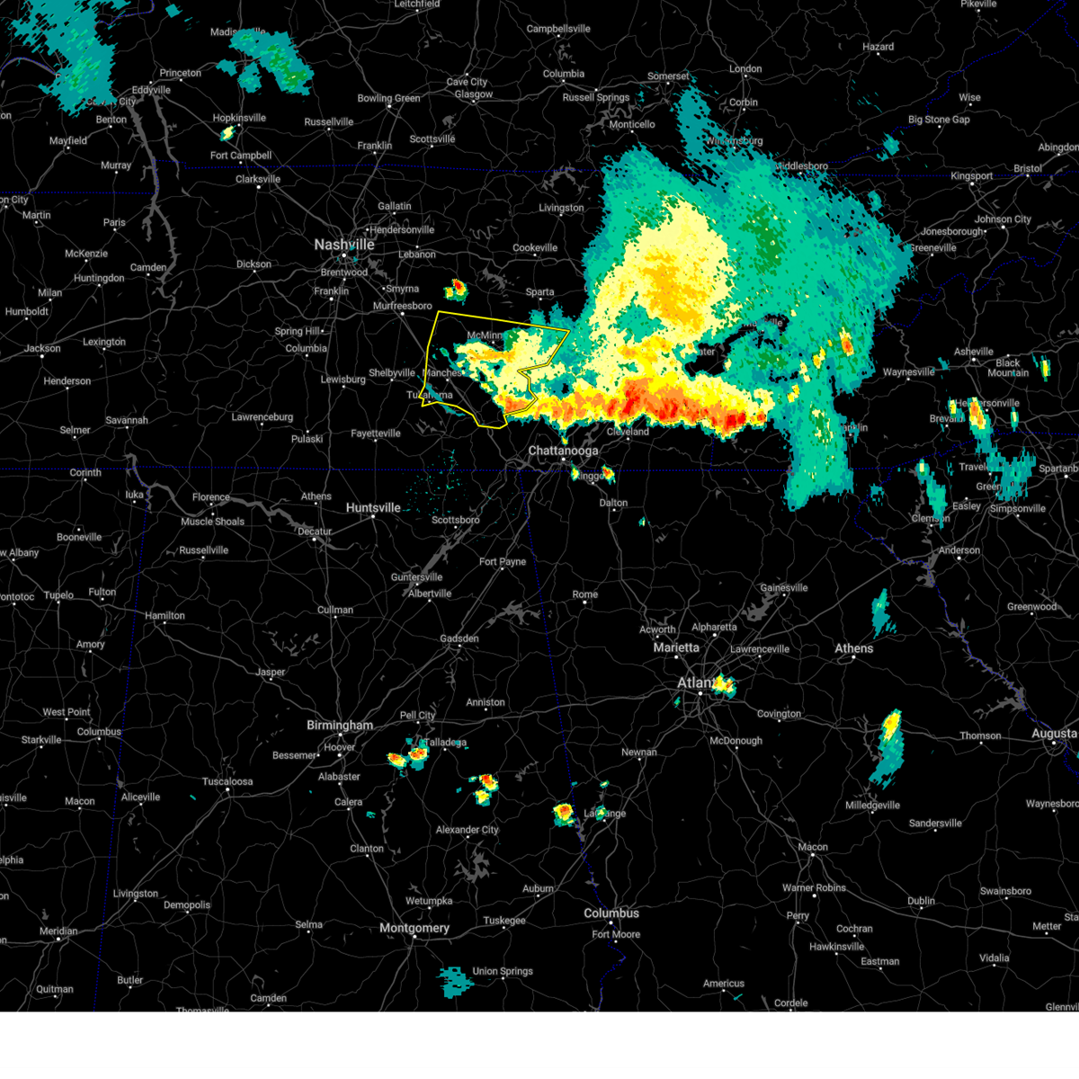
The Top Recent Hail Date for Woodbury, TN is Tuesday, May 20, 2025 (5th out of 51)

Hail and Wind Damage Spotted near Woodbury, TN
| Date / Time | Report Details |
|---|---|
| 5/20/2025 6:35 PM CDT |
 The storm which prompted the warning has moved out of the area. therefore the warning will be allowed to expire. a tornado watch remains in effect until 1000 pm cdt for middle tennessee. The storm which prompted the warning has moved out of the area. therefore the warning will be allowed to expire. a tornado watch remains in effect until 1000 pm cdt for middle tennessee.
|
| 5/20/2025 6:17 PM CDT | the tornado warning has been cancelled and is no longer in effect |
| 5/20/2025 6:17 PM CDT | At 616 pm cdt, a severe thunderstorm capable of producing a tornado was located near bradyville, moving east at 35 mph (radar indicated rotation). Hazards include tornado and half dollar size hail. Flying debris will be dangerous to those caught without shelter. mobile homes will be damaged or destroyed. damage to roofs, windows, and vehicles will occur. tree damage is likely. Locations impacted include, bradyville and woodbury. |
| 5/20/2025 6:08 PM CDT |
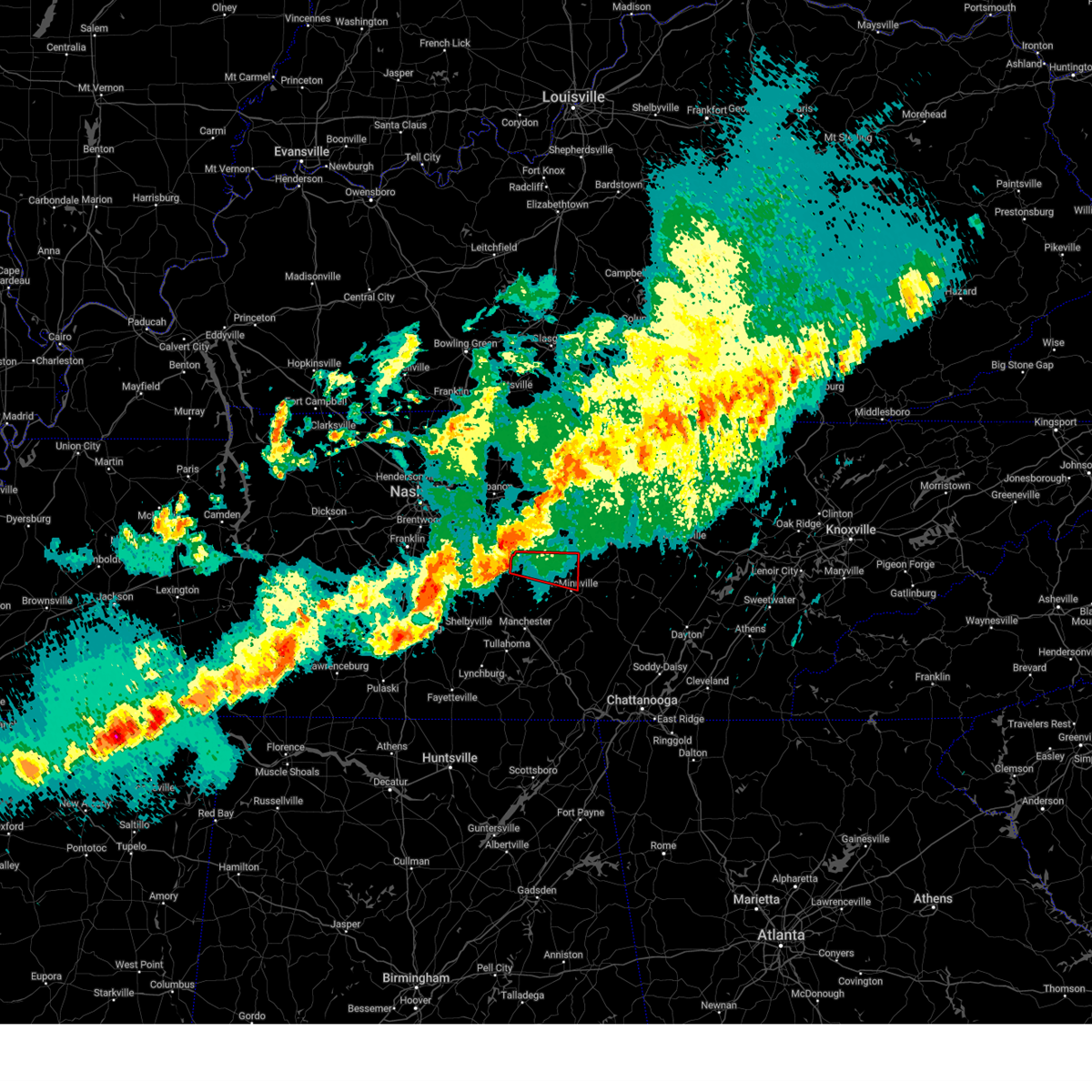
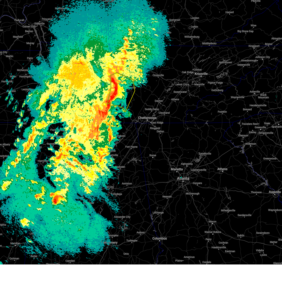
 At 608 pm cdt, a severe thunderstorm was located near smithville, moving east at 40 mph (radar indicated). Hazards include ping pong ball size hail and 60 mph wind gusts. People and animals outdoors will be injured. expect hail damage to roofs, siding, windows, and vehicles. expect wind damage to roofs, siding, and trees. Locations impacted include, center hill lake, smithville, dowelltown, liberty, edgar evins state park, readyville, and woodbury. At 608 pm cdt, a severe thunderstorm was located near smithville, moving east at 40 mph (radar indicated). Hazards include ping pong ball size hail and 60 mph wind gusts. People and animals outdoors will be injured. expect hail damage to roofs, siding, windows, and vehicles. expect wind damage to roofs, siding, and trees. Locations impacted include, center hill lake, smithville, dowelltown, liberty, edgar evins state park, readyville, and woodbury.
|
| 5/20/2025 6:08 PM CDT |
 the severe thunderstorm warning has been cancelled and is no longer in effect the severe thunderstorm warning has been cancelled and is no longer in effect
|
| 5/20/2025 5:55 PM CDT | Torohx the national weather service in nashville has issued a * tornado warning for, southeastern rutherford county in middle tennessee, northwestern coffee county in middle tennessee, cannon county in middle tennessee, * until 630 pm cdt. * at 555 pm cdt, a severe thunderstorm capable of producing a tornado was located 12 miles south of murfreesboro, moving east at 50 mph (radar indicated rotation). Hazards include tornado and golf ball size hail. Flying debris will be dangerous to those caught without shelter. mobile homes will be damaged or destroyed. damage to roofs, windows, and vehicles will occur. Tree damage is likely. |
| 5/20/2025 5:39 PM CDT | Svrohx the national weather service in nashville has issued a * severe thunderstorm warning for, de kalb county in middle tennessee, northeastern rutherford county in middle tennessee, southeastern wilson county in middle tennessee, northern cannon county in middle tennessee, * until 645 pm cdt. * at 539 pm cdt, a severe thunderstorm was located 9 miles southeast of walterhill, or 10 miles east of murfreesboro, moving east at 35 mph (radar indicated). Hazards include golf ball size hail and 60 mph wind gusts. People and animals outdoors will be injured. expect hail damage to roofs, siding, windows, and vehicles. Expect wind damage to roofs, siding, and trees. |
| 5/20/2025 5:34 PM CDT | At 533 pm cdt, a severe thunderstorm was located near walterhill, or 8 miles northeast of murfreesboro, moving east at 40 mph (radar indicated). Hazards include ping pong ball size hail and 60 mph wind gusts. People and animals outdoors will be injured. expect hail damage to roofs, siding, windows, and vehicles. expect wind damage to roofs, siding, and trees. Locations impacted include, lascassas, murfreesboro, nolensville, walterhill, brentwood, la vergne, triune, cedars of lebanon state park, auburntown, eagleville, woodbury, rockvale, smyrna, milton, readyville, and franklin. |
| 5/20/2025 4:49 PM CDT |
 Svrohx the national weather service in nashville has issued a * severe thunderstorm warning for, southeastern davidson county in middle tennessee, rutherford county in middle tennessee, eastern williamson county in middle tennessee, southeastern wilson county in middle tennessee, northwestern cannon county in middle tennessee, * until 545 pm cdt. * at 448 pm cdt, a severe thunderstorm was located near nolensville, or 7 miles southeast of franklin, moving east at 45 mph. this is a destructive storm for williamson and rutherford counties (trained weather spotters. at 445 pm cdt...numerous reports of golfball to tennis ball size hail were received in franklin). Hazards include baseball size hail and 60 mph wind gusts. People and animals outdoors will be severely injured. Expect shattered windows, extensive damage to roofs, siding, and vehicles. Svrohx the national weather service in nashville has issued a * severe thunderstorm warning for, southeastern davidson county in middle tennessee, rutherford county in middle tennessee, eastern williamson county in middle tennessee, southeastern wilson county in middle tennessee, northwestern cannon county in middle tennessee, * until 545 pm cdt. * at 448 pm cdt, a severe thunderstorm was located near nolensville, or 7 miles southeast of franklin, moving east at 45 mph. this is a destructive storm for williamson and rutherford counties (trained weather spotters. at 445 pm cdt...numerous reports of golfball to tennis ball size hail were received in franklin). Hazards include baseball size hail and 60 mph wind gusts. People and animals outdoors will be severely injured. Expect shattered windows, extensive damage to roofs, siding, and vehicles.
|
| 4/10/2025 6:30 PM CDT |
 At 630 pm cdt, severe thunderstorms were located along a line extending from near smithville to 6 miles northeast of estill springs, moving east at 40 mph (radar indicated). Hazards include 60 mph wind gusts. Expect damage to roofs, siding, and trees. locations impacted include, woodbury, morrison, hillsboro, centertown, manchester, viola, summitville, auburntown, arnold afb, and mcminnville. This includes interstate 24 between mile markers 104 and 126. At 630 pm cdt, severe thunderstorms were located along a line extending from near smithville to 6 miles northeast of estill springs, moving east at 40 mph (radar indicated). Hazards include 60 mph wind gusts. Expect damage to roofs, siding, and trees. locations impacted include, woodbury, morrison, hillsboro, centertown, manchester, viola, summitville, auburntown, arnold afb, and mcminnville. This includes interstate 24 between mile markers 104 and 126.
|
| 4/10/2025 6:30 PM CDT |
 the severe thunderstorm warning has been cancelled and is no longer in effect the severe thunderstorm warning has been cancelled and is no longer in effect
|
| 4/10/2025 6:15 PM CDT |
 the severe thunderstorm warning has been cancelled and is no longer in effect the severe thunderstorm warning has been cancelled and is no longer in effect
|
| 4/10/2025 6:15 PM CDT |
 At 614 pm cdt, severe thunderstorms were located along a line extending from 6 miles east of hartsville to near woodbury, moving east at 35 mph (radar indicated). Hazards include 60 mph wind gusts. Expect damage to roofs, siding, and trees. locations impacted include, gordonsville, hartsville, pleasant shade, dickerson chapel recreation area, liberty, cedars of lebanon state park, carthage, auburntown, center hill lake, alexandria, edgar evins state park, south carthage, lascassas, tuckers crossroads, hickman, walterhill, dixon springs, dowelltown, lebanon, and watertown. this includes the following highways, interstate 40 between mile markers 234 and 267. Interstate 840 between mile markers 54 and 76. At 614 pm cdt, severe thunderstorms were located along a line extending from 6 miles east of hartsville to near woodbury, moving east at 35 mph (radar indicated). Hazards include 60 mph wind gusts. Expect damage to roofs, siding, and trees. locations impacted include, gordonsville, hartsville, pleasant shade, dickerson chapel recreation area, liberty, cedars of lebanon state park, carthage, auburntown, center hill lake, alexandria, edgar evins state park, south carthage, lascassas, tuckers crossroads, hickman, walterhill, dixon springs, dowelltown, lebanon, and watertown. this includes the following highways, interstate 40 between mile markers 234 and 267. Interstate 840 between mile markers 54 and 76.
|
| 4/10/2025 5:59 PM CDT |
 At 558 pm cdt, severe thunderstorms were located along a line extending from near hartsville to 8 miles southeast of murfreesboro, moving east at 35 mph (radar indicated). Hazards include 60 mph wind gusts. Expect damage to roofs, siding, and trees. locations impacted include, gordonsville, hartsville, pleasant shade, la vergne, gallatin, bledsoe creek state park, dickerson chapel recreation area, liberty, cedars of lebanon state park, carthage, auburntown, center hill lake, mount juliet, alexandria, smyrna, edgar evins state park, south carthage, lascassas, tuckers crossroads, and hickman. this includes the following highways, interstate 40 between mile markers 225 and 267. interstate 24 between mile markers 66 and 73. Interstate 840 between mile markers 54 and 76. At 558 pm cdt, severe thunderstorms were located along a line extending from near hartsville to 8 miles southeast of murfreesboro, moving east at 35 mph (radar indicated). Hazards include 60 mph wind gusts. Expect damage to roofs, siding, and trees. locations impacted include, gordonsville, hartsville, pleasant shade, la vergne, gallatin, bledsoe creek state park, dickerson chapel recreation area, liberty, cedars of lebanon state park, carthage, auburntown, center hill lake, mount juliet, alexandria, smyrna, edgar evins state park, south carthage, lascassas, tuckers crossroads, and hickman. this includes the following highways, interstate 40 between mile markers 225 and 267. interstate 24 between mile markers 66 and 73. Interstate 840 between mile markers 54 and 76.
|
| 4/10/2025 5:59 PM CDT |
 the severe thunderstorm warning has been cancelled and is no longer in effect the severe thunderstorm warning has been cancelled and is no longer in effect
|
| 4/10/2025 5:52 PM CDT |
 Svrohx the national weather service in nashville has issued a * severe thunderstorm warning for, southwestern de kalb county in middle tennessee, southeastern rutherford county in middle tennessee, western warren county in middle tennessee, coffee county in middle tennessee, bedford county in middle tennessee, cannon county in middle tennessee, * until 645 pm cdt. * at 551 pm cdt, severe thunderstorms were located along a line extending from near walterhill to near petersburg, moving east at 25 mph (radar indicated). Hazards include 60 mph wind gusts. expect damage to roofs, siding, and trees Svrohx the national weather service in nashville has issued a * severe thunderstorm warning for, southwestern de kalb county in middle tennessee, southeastern rutherford county in middle tennessee, western warren county in middle tennessee, coffee county in middle tennessee, bedford county in middle tennessee, cannon county in middle tennessee, * until 645 pm cdt. * at 551 pm cdt, severe thunderstorms were located along a line extending from near walterhill to near petersburg, moving east at 25 mph (radar indicated). Hazards include 60 mph wind gusts. expect damage to roofs, siding, and trees
|
| 4/10/2025 5:41 PM CDT | Svrohx the national weather service in nashville has issued a * severe thunderstorm warning for, smith county in middle tennessee, southeastern davidson county in middle tennessee, western de kalb county in middle tennessee, northern rutherford county in middle tennessee, southern sumner county in middle tennessee, northeastern williamson county in middle tennessee, wilson county in middle tennessee, southern macon county in middle tennessee, trousdale county in middle tennessee, northern cannon county in middle tennessee, * until 630 pm cdt. * at 541 pm cdt, severe thunderstorms were located along a line extending from 6 miles northeast of gallatin to near murfreesboro, moving east at 35 mph (radar indicated). Hazards include 60 mph wind gusts. expect damage to roofs, siding, and trees |
| 4/5/2025 11:41 PM CDT |
 the severe thunderstorm warning has been cancelled and is no longer in effect the severe thunderstorm warning has been cancelled and is no longer in effect
|
| 4/5/2025 11:29 PM CDT |
 At 1128 pm cdt, severe thunderstorms were located along a line extending from 6 miles southeast of watertown to 11 miles northwest of manchester, moving northeast at 40 mph (radar indicated). Hazards include 60 mph wind gusts and penny size hail. Expect damage to roofs, siding, and trees. locations impacted include, morrison, centertown, smithville, dowelltown, beechgrove, liberty, summitville, auburntown, center hill lake, woodbury, bradyville, alexandria, edgar evins state park, and readyville. This includes interstate 24 between mile markers 97 and 106. At 1128 pm cdt, severe thunderstorms were located along a line extending from 6 miles southeast of watertown to 11 miles northwest of manchester, moving northeast at 40 mph (radar indicated). Hazards include 60 mph wind gusts and penny size hail. Expect damage to roofs, siding, and trees. locations impacted include, morrison, centertown, smithville, dowelltown, beechgrove, liberty, summitville, auburntown, center hill lake, woodbury, bradyville, alexandria, edgar evins state park, and readyville. This includes interstate 24 between mile markers 97 and 106.
|
| 4/5/2025 11:29 PM CDT |
 the severe thunderstorm warning has been cancelled and is no longer in effect the severe thunderstorm warning has been cancelled and is no longer in effect
|
| 4/5/2025 11:08 PM CDT |
 Svrohx the national weather service in nashville has issued a * severe thunderstorm warning for, de kalb county in middle tennessee, eastern rutherford county in middle tennessee, western warren county in middle tennessee, northern coffee county in middle tennessee, southeastern wilson county in middle tennessee, northeastern bedford county in middle tennessee, cannon county in middle tennessee, * until 1215 am cdt. * at 1108 pm cdt, severe thunderstorms were located along a line extending from near walterhill to near shelbyville, moving northeast at 40 mph (radar indicated). Hazards include 60 mph wind gusts and penny size hail. expect damage to roofs, siding, and trees Svrohx the national weather service in nashville has issued a * severe thunderstorm warning for, de kalb county in middle tennessee, eastern rutherford county in middle tennessee, western warren county in middle tennessee, northern coffee county in middle tennessee, southeastern wilson county in middle tennessee, northeastern bedford county in middle tennessee, cannon county in middle tennessee, * until 1215 am cdt. * at 1108 pm cdt, severe thunderstorms were located along a line extending from near walterhill to near shelbyville, moving northeast at 40 mph (radar indicated). Hazards include 60 mph wind gusts and penny size hail. expect damage to roofs, siding, and trees
|
| 3/31/2025 1:06 AM CDT |
 the tornado warning has been cancelled and is no longer in effect the tornado warning has been cancelled and is no longer in effect
|
| 3/31/2025 1:05 AM CDT | Tspotter report of 3 large trees down and shingle damage to a home near locks creek/county lane east of readyville. time is radar estimate in cannon county TN, 3.9 miles E of Woodbury, TN |
| 3/31/2025 1:05 AM CDT |
 At 105 am cdt, a severe thunderstorm was located 8 miles south of smithville, moving east at 40 mph (radar indicated). Hazards include 60 mph wind gusts and penny size hail. Expect damage to roofs, siding, and trees. locations impacted include, bradyville, christiana, murfreesboro, woodbury, readyville, and auburntown. This includes interstate 24 between mile markers 80 and 92. At 105 am cdt, a severe thunderstorm was located 8 miles south of smithville, moving east at 40 mph (radar indicated). Hazards include 60 mph wind gusts and penny size hail. Expect damage to roofs, siding, and trees. locations impacted include, bradyville, christiana, murfreesboro, woodbury, readyville, and auburntown. This includes interstate 24 between mile markers 80 and 92.
|
| 3/31/2025 1:05 AM CDT |
 the severe thunderstorm warning has been cancelled and is no longer in effect the severe thunderstorm warning has been cancelled and is no longer in effect
|
| 3/31/2025 12:53 AM CDT |
 At 1253 am cdt, a severe thunderstorm capable of producing a tornado was located near woodbury, moving east at 40 mph (radar indicated rotation). Hazards include tornado and quarter size hail. Flying debris will be dangerous to those caught without shelter. mobile homes will be damaged or destroyed. damage to roofs, windows, and vehicles will occur. tree damage is likely. This tornadic thunderstorm will remain over mainly rural areas of south central de kalb, northwestern warren and east central cannon counties. At 1253 am cdt, a severe thunderstorm capable of producing a tornado was located near woodbury, moving east at 40 mph (radar indicated rotation). Hazards include tornado and quarter size hail. Flying debris will be dangerous to those caught without shelter. mobile homes will be damaged or destroyed. damage to roofs, windows, and vehicles will occur. tree damage is likely. This tornadic thunderstorm will remain over mainly rural areas of south central de kalb, northwestern warren and east central cannon counties.
|
| 3/31/2025 12:44 AM CDT |
 At 1244 am cdt, a severe thunderstorm was located over woodbury, moving east at 40 mph (radar indicated). Hazards include ping pong ball size hail and 60 mph wind gusts. People and animals outdoors will be injured. expect hail damage to roofs, siding, windows, and vehicles. expect wind damage to roofs, siding, and trees. locations impacted include, auburntown, lascassas, christiana, eagleville, murfreesboro, woodbury, rockvale, dowelltown, bradyville, milton, liberty, and readyville. this includes the following highways, interstate 24 between mile markers 74 and 93. Interstate 840 between mile markers 47 and 55. At 1244 am cdt, a severe thunderstorm was located over woodbury, moving east at 40 mph (radar indicated). Hazards include ping pong ball size hail and 60 mph wind gusts. People and animals outdoors will be injured. expect hail damage to roofs, siding, windows, and vehicles. expect wind damage to roofs, siding, and trees. locations impacted include, auburntown, lascassas, christiana, eagleville, murfreesboro, woodbury, rockvale, dowelltown, bradyville, milton, liberty, and readyville. this includes the following highways, interstate 24 between mile markers 74 and 93. Interstate 840 between mile markers 47 and 55.
|
| 3/31/2025 12:44 AM CDT |
 the severe thunderstorm warning has been cancelled and is no longer in effect the severe thunderstorm warning has been cancelled and is no longer in effect
|
| 3/31/2025 12:41 AM CDT |
 Torohx the national weather service in nashville has issued a * tornado warning for, south central de kalb county in middle tennessee, northwestern warren county in middle tennessee, central cannon county in middle tennessee, * until 130 am cdt. * at 1241 am cdt, a severe thunderstorm capable of producing a tornado was located near woodbury, moving east at 40 mph (radar indicated rotation). Hazards include tornado and quarter size hail. Flying debris will be dangerous to those caught without shelter. mobile homes will be damaged or destroyed. damage to roofs, windows, and vehicles will occur. tree damage is likely. this dangerous storm will be near, woodbury around 1245 am cdt. Other locations impacted by this tornadic thunderstorm include readyville and centertown. Torohx the national weather service in nashville has issued a * tornado warning for, south central de kalb county in middle tennessee, northwestern warren county in middle tennessee, central cannon county in middle tennessee, * until 130 am cdt. * at 1241 am cdt, a severe thunderstorm capable of producing a tornado was located near woodbury, moving east at 40 mph (radar indicated rotation). Hazards include tornado and quarter size hail. Flying debris will be dangerous to those caught without shelter. mobile homes will be damaged or destroyed. damage to roofs, windows, and vehicles will occur. tree damage is likely. this dangerous storm will be near, woodbury around 1245 am cdt. Other locations impacted by this tornadic thunderstorm include readyville and centertown.
|
| 3/31/2025 12:11 AM CDT |
 Svrohx the national weather service in nashville has issued a * severe thunderstorm warning for, southwestern de kalb county in middle tennessee, rutherford county in middle tennessee, southeastern williamson county in middle tennessee, southeastern wilson county in middle tennessee, cannon county in middle tennessee, * until 115 am cdt. * at 1211 am cdt, a severe thunderstorm was located near murfreesboro, moving east at 40 mph (radar indicated). Hazards include ping pong ball size hail and 60 mph wind gusts. People and animals outdoors will be injured. expect hail damage to roofs, siding, windows, and vehicles. Expect wind damage to roofs, siding, and trees. Svrohx the national weather service in nashville has issued a * severe thunderstorm warning for, southwestern de kalb county in middle tennessee, rutherford county in middle tennessee, southeastern williamson county in middle tennessee, southeastern wilson county in middle tennessee, cannon county in middle tennessee, * until 115 am cdt. * at 1211 am cdt, a severe thunderstorm was located near murfreesboro, moving east at 40 mph (radar indicated). Hazards include ping pong ball size hail and 60 mph wind gusts. People and animals outdoors will be injured. expect hail damage to roofs, siding, windows, and vehicles. Expect wind damage to roofs, siding, and trees.
|
| 3/15/2025 4:10 PM CDT |
 At 409 pm cdt, severe thunderstorms were located along a line extending from 6 miles west of smithville to near mcminnville to 9 miles east of manchester, moving east at 55 mph (radar indicated). Hazards include 60 mph wind gusts and penny size hail. Expect damage to roofs, siding, and trees. locations impacted include, morrison, centertown, tullahoma, summitville, woodbury, mcminnville, hillsboro, pelham, manchester, viola, altamont, monteagle, and arnold afb. This includes interstate 24 between mile markers 104 and 133. At 409 pm cdt, severe thunderstorms were located along a line extending from 6 miles west of smithville to near mcminnville to 9 miles east of manchester, moving east at 55 mph (radar indicated). Hazards include 60 mph wind gusts and penny size hail. Expect damage to roofs, siding, and trees. locations impacted include, morrison, centertown, tullahoma, summitville, woodbury, mcminnville, hillsboro, pelham, manchester, viola, altamont, monteagle, and arnold afb. This includes interstate 24 between mile markers 104 and 133.
|
| 3/15/2025 4:10 PM CDT |
 the severe thunderstorm warning has been cancelled and is no longer in effect the severe thunderstorm warning has been cancelled and is no longer in effect
|
| 3/15/2025 3:55 PM CDT |
 At 355 pm cdt, severe thunderstorms were located along a line extending from 10 miles south of watertown to 7 miles southeast of woodbury to near manchester, moving east at 55 mph (radar indicated). Hazards include 60 mph wind gusts and penny size hail. Expect damage to roofs, siding, and trees. locations impacted include, morrison, centertown, tullahoma, beechgrove, raus, summitville, auburntown, woodbury, mcminnville, hillsboro, pelham, manchester, bradyville, normandy, milton, viola, readyville, liberty, altamont, and monteagle. This includes interstate 24 between mile markers 95 and 133. At 355 pm cdt, severe thunderstorms were located along a line extending from 10 miles south of watertown to 7 miles southeast of woodbury to near manchester, moving east at 55 mph (radar indicated). Hazards include 60 mph wind gusts and penny size hail. Expect damage to roofs, siding, and trees. locations impacted include, morrison, centertown, tullahoma, beechgrove, raus, summitville, auburntown, woodbury, mcminnville, hillsboro, pelham, manchester, bradyville, normandy, milton, viola, readyville, liberty, altamont, and monteagle. This includes interstate 24 between mile markers 95 and 133.
|
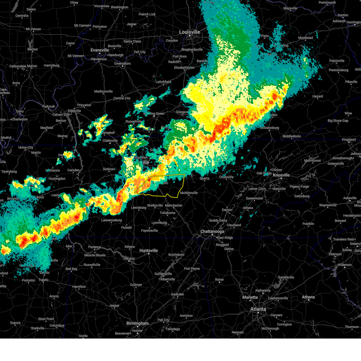
| 3/15/2025 3:40 PM CDT | Torohx the national weather service in nashville has issued a * tornado warning for, cannon county in middle tennessee, * until 430 pm cdt. * at 340 pm cdt, a severe thunderstorm capable of producing a tornado was located 9 miles southwest of woodbury, moving east at 55 mph (radar indicated rotation). Hazards include tornado. Flying debris will be dangerous to those caught without shelter. mobile homes will be damaged or destroyed. damage to roofs, windows, and vehicles will occur. tree damage is likely. this dangerous storm will be near, woodbury around 345 pm cdt. Other locations impacted by this tornadic thunderstorm include auburntown, bradyville, and readyville. |
| 3/15/2025 3:38 PM CDT | Svrohx the national weather service in nashville has issued a * severe thunderstorm warning for, southern de kalb county in middle tennessee, eastern rutherford county in middle tennessee, warren county in middle tennessee, coffee county in middle tennessee, southeastern wilson county in middle tennessee, eastern bedford county in middle tennessee, western grundy county in middle tennessee, cannon county in middle tennessee, * until 430 pm cdt. * at 338 pm cdt, severe thunderstorms were located along a line extending from murfreesboro to 15 miles northeast of shelbyville to near lynchburg, moving east at 55 mph (radar indicated). Hazards include 60 mph wind gusts and penny size hail. expect damage to roofs, siding, and trees |
| 8/2/2024 3:10 PM CDT |
 The storm which prompted the warning has weakened below severe limits, and no longer poses an immediate threat to life or property. therefore, the warning will be allowed to expire. however, gusty winds are still possible with this thunderstorm. The storm which prompted the warning has weakened below severe limits, and no longer poses an immediate threat to life or property. therefore, the warning will be allowed to expire. however, gusty winds are still possible with this thunderstorm.
|
| 8/2/2024 2:45 PM CDT |
 Svrohx the national weather service in nashville has issued a * severe thunderstorm warning for, northwestern warren county in middle tennessee, central cannon county in middle tennessee, * until 315 pm cdt. * at 245 pm cdt, a severe thunderstorm was located over woodbury, moving east at 30 mph (radar indicated). Hazards include 60 mph wind gusts. expect damage to roofs, siding, and trees Svrohx the national weather service in nashville has issued a * severe thunderstorm warning for, northwestern warren county in middle tennessee, central cannon county in middle tennessee, * until 315 pm cdt. * at 245 pm cdt, a severe thunderstorm was located over woodbury, moving east at 30 mph (radar indicated). Hazards include 60 mph wind gusts. expect damage to roofs, siding, and trees
|
| 7/30/2024 8:46 PM CDT |
 the severe thunderstorm warning has been cancelled and is no longer in effect the severe thunderstorm warning has been cancelled and is no longer in effect
|
| 7/30/2024 8:40 PM CDT |
 At 840 pm cdt, a severe thunderstorm was located over woodbury, moving east at 35 mph (radar indicated). Hazards include 60 mph wind gusts and penny size hail. Expect damage to roofs, siding, and trees. Locations impacted include, woodbury, auburntown, and bradyville. At 840 pm cdt, a severe thunderstorm was located over woodbury, moving east at 35 mph (radar indicated). Hazards include 60 mph wind gusts and penny size hail. Expect damage to roofs, siding, and trees. Locations impacted include, woodbury, auburntown, and bradyville.
|
| 7/30/2024 8:40 PM CDT |
 the severe thunderstorm warning has been cancelled and is no longer in effect the severe thunderstorm warning has been cancelled and is no longer in effect
|
| 7/30/2024 8:11 PM CDT |
 Svrohx the national weather service in nashville has issued a * severe thunderstorm warning for, east central rutherford county in middle tennessee, cannon county in middle tennessee, * until 900 pm cdt. * at 811 pm cdt, a severe thunderstorm was located over murfreesboro, moving east at 35 mph (radar indicated). Hazards include 60 mph wind gusts and quarter size hail. Hail damage to vehicles is expected. Expect wind damage to roofs, siding, and trees. Svrohx the national weather service in nashville has issued a * severe thunderstorm warning for, east central rutherford county in middle tennessee, cannon county in middle tennessee, * until 900 pm cdt. * at 811 pm cdt, a severe thunderstorm was located over murfreesboro, moving east at 35 mph (radar indicated). Hazards include 60 mph wind gusts and quarter size hail. Hail damage to vehicles is expected. Expect wind damage to roofs, siding, and trees.
|
| 7/30/2024 5:06 PM CDT |
 The storms which prompted the warning have weakened below severe limits, and no longer pose an immediate threat to life or property. therefore, the warning will be allowed to expire. a severe thunderstorm watch remains in effect until 800 pm cdt for middle tennessee. to report severe weather, contact your nearest law enforcement agency. they will relay your report to the national weather service nashville. The storms which prompted the warning have weakened below severe limits, and no longer pose an immediate threat to life or property. therefore, the warning will be allowed to expire. a severe thunderstorm watch remains in effect until 800 pm cdt for middle tennessee. to report severe weather, contact your nearest law enforcement agency. they will relay your report to the national weather service nashville.
|
| 7/30/2024 4:37 PM CDT |
 the severe thunderstorm warning has been cancelled and is no longer in effect the severe thunderstorm warning has been cancelled and is no longer in effect
|
| 7/30/2024 4:37 PM CDT |
 At 437 pm cdt, severe thunderstorms were located along a line extending from bell buckle to fall creek falls, moving southeast at 40 mph (radar indicated). Hazards include 60 mph wind gusts and quarter size hail. Hail damage to vehicles is expected. expect wind damage to roofs, siding, and trees. locations impacted include, mcminnville, manchester, woodbury, spencer, tullahoma, gruetli-laager, tracy city, monteagle, altamont, coalmont, morrison, palmer, beersheba springs, centertown, viola, summitville, fall creek falls state park, hillsboro, pelham, and bradyville. This includes interstate 24 between mile markers 101 and 136. At 437 pm cdt, severe thunderstorms were located along a line extending from bell buckle to fall creek falls, moving southeast at 40 mph (radar indicated). Hazards include 60 mph wind gusts and quarter size hail. Hail damage to vehicles is expected. expect wind damage to roofs, siding, and trees. locations impacted include, mcminnville, manchester, woodbury, spencer, tullahoma, gruetli-laager, tracy city, monteagle, altamont, coalmont, morrison, palmer, beersheba springs, centertown, viola, summitville, fall creek falls state park, hillsboro, pelham, and bradyville. This includes interstate 24 between mile markers 101 and 136.
|
| 7/30/2024 4:20 PM CDT | At 420 pm cdt, severe thunderstorms were located along a line extending from mcminnville to near murfreesboro, moving south at 40 mph (radar indicated). Hazards include 60 mph wind gusts and quarter size hail. Hail damage to vehicles is expected. expect wind damage to roofs, siding, and trees. locations impacted include, murfreesboro, mcminnville, smithville, woodbury, walterhill, dowelltown, liberty, auburntown, centertown, lascassas, cedars of lebanon state park, bradyville, milton, and readyville. This includes interstate 24 between mile markers 80 and 89. |
| 7/30/2024 4:20 PM CDT | the severe thunderstorm warning has been cancelled and is no longer in effect |
| 7/30/2024 4:10 PM CDT |
 Svrohx the national weather service in nashville has issued a * severe thunderstorm warning for, southeastern rutherford county in middle tennessee, van buren county in middle tennessee, warren county in middle tennessee, coffee county in middle tennessee, bedford county in middle tennessee, grundy county in middle tennessee, cannon county in middle tennessee, * until 515 pm cdt. * at 409 pm cdt, severe thunderstorms were located along a line extending from murfreesboro to spencer, moving south at 30 mph (radar indicated). Hazards include 60 mph wind gusts and quarter size hail. Hail damage to vehicles is expected. Expect wind damage to roofs, siding, and trees. Svrohx the national weather service in nashville has issued a * severe thunderstorm warning for, southeastern rutherford county in middle tennessee, van buren county in middle tennessee, warren county in middle tennessee, coffee county in middle tennessee, bedford county in middle tennessee, grundy county in middle tennessee, cannon county in middle tennessee, * until 515 pm cdt. * at 409 pm cdt, severe thunderstorms were located along a line extending from murfreesboro to spencer, moving south at 30 mph (radar indicated). Hazards include 60 mph wind gusts and quarter size hail. Hail damage to vehicles is expected. Expect wind damage to roofs, siding, and trees.
|
| 7/30/2024 4:01 PM CDT |
 the severe thunderstorm warning has been cancelled and is no longer in effect the severe thunderstorm warning has been cancelled and is no longer in effect
|
| 7/30/2024 4:01 PM CDT |
 At 401 pm cdt, severe thunderstorms were located along a line extending from smithville to near smyrna, moving south at 40 mph (radar indicated). Hazards include 60 mph wind gusts and quarter size hail. Hail damage to vehicles is expected. expect wind damage to roofs, siding, and trees. locations impacted include, murfreesboro, mcminnville, smithville, woodbury, watertown, walterhill, alexandria, dowelltown, liberty, auburntown, centertown, lascassas, cedars of lebanon state park, bradyville, milton, gladeville, and readyville. this includes the following highways, interstate 24 between mile markers 78 and 89. Interstate 840 between mile markers 55 and 72. At 401 pm cdt, severe thunderstorms were located along a line extending from smithville to near smyrna, moving south at 40 mph (radar indicated). Hazards include 60 mph wind gusts and quarter size hail. Hail damage to vehicles is expected. expect wind damage to roofs, siding, and trees. locations impacted include, murfreesboro, mcminnville, smithville, woodbury, watertown, walterhill, alexandria, dowelltown, liberty, auburntown, centertown, lascassas, cedars of lebanon state park, bradyville, milton, gladeville, and readyville. this includes the following highways, interstate 24 between mile markers 78 and 89. Interstate 840 between mile markers 55 and 72.
|
| 7/30/2024 3:42 PM CDT |
 Svrohx the national weather service in nashville has issued a * severe thunderstorm warning for, southwestern smith county in middle tennessee, southeastern davidson county in middle tennessee, western de kalb county in middle tennessee, rutherford county in middle tennessee, northwestern warren county in middle tennessee, east central williamson county in middle tennessee, wilson county in middle tennessee, cannon county in middle tennessee, * until 430 pm cdt. * at 342 pm cdt, severe thunderstorms were located along a line extending from percy priest lake to alexandria, moving south at 40 mph (radar indicated). Hazards include 60 mph wind gusts and quarter size hail. Hail damage to vehicles is expected. Expect wind damage to roofs, siding, and trees. Svrohx the national weather service in nashville has issued a * severe thunderstorm warning for, southwestern smith county in middle tennessee, southeastern davidson county in middle tennessee, western de kalb county in middle tennessee, rutherford county in middle tennessee, northwestern warren county in middle tennessee, east central williamson county in middle tennessee, wilson county in middle tennessee, cannon county in middle tennessee, * until 430 pm cdt. * at 342 pm cdt, severe thunderstorms were located along a line extending from percy priest lake to alexandria, moving south at 40 mph (radar indicated). Hazards include 60 mph wind gusts and quarter size hail. Hail damage to vehicles is expected. Expect wind damage to roofs, siding, and trees.
|
| 5/26/2024 4:41 PM CDT |
 The storm which prompted the warning has weakened below severe limits, and no longer poses an immediate threat to life or property. therefore, the warning will be allowed to expire. however, small hail is still possible with this thunderstorm and a special weather statement for a strong thunderstorm is now in effect. a tornado watch remains in effect until 600 pm cdt for middle tennessee. The storm which prompted the warning has weakened below severe limits, and no longer poses an immediate threat to life or property. therefore, the warning will be allowed to expire. however, small hail is still possible with this thunderstorm and a special weather statement for a strong thunderstorm is now in effect. a tornado watch remains in effect until 600 pm cdt for middle tennessee.
|
| 5/26/2024 4:24 PM CDT |
 At 423 pm cdt, a severe thunderstorm was located 7 miles southeast of woodbury, moving east at 45 mph (radar indicated). Hazards include 60 mph wind gusts and nickel size hail. Expect damage to roofs, siding, and trees. Locations impacted include, mcminnville, woodbury, morrison, centertown, bradyville, rock island state park, and readyville. At 423 pm cdt, a severe thunderstorm was located 7 miles southeast of woodbury, moving east at 45 mph (radar indicated). Hazards include 60 mph wind gusts and nickel size hail. Expect damage to roofs, siding, and trees. Locations impacted include, mcminnville, woodbury, morrison, centertown, bradyville, rock island state park, and readyville.
|
| 5/26/2024 4:24 PM CDT |
 the severe thunderstorm warning has been cancelled and is no longer in effect the severe thunderstorm warning has been cancelled and is no longer in effect
|
| 5/26/2024 4:11 PM CDT |
 Svrohx the national weather service in nashville has issued a * severe thunderstorm warning for, southeastern rutherford county in middle tennessee, warren county in middle tennessee, cannon county in middle tennessee, * until 445 pm cdt. * at 411 pm cdt, a severe thunderstorm was located near woodbury, moving east at 45 mph (radar indicated). Hazards include 60 mph wind gusts and quarter size hail. Hail damage to vehicles is expected. Expect wind damage to roofs, siding, and trees. Svrohx the national weather service in nashville has issued a * severe thunderstorm warning for, southeastern rutherford county in middle tennessee, warren county in middle tennessee, cannon county in middle tennessee, * until 445 pm cdt. * at 411 pm cdt, a severe thunderstorm was located near woodbury, moving east at 45 mph (radar indicated). Hazards include 60 mph wind gusts and quarter size hail. Hail damage to vehicles is expected. Expect wind damage to roofs, siding, and trees.
|
| 5/26/2024 3:53 PM CDT |
 At 353 pm cdt, a severe thunderstorm was located near murfreesboro, moving east at 50 mph (radar indicated). Hazards include ping pong ball size hail and 60 mph wind gusts. People and animals outdoors will be injured. expect hail damage to roofs, siding, windows, and vehicles. expect wind damage to roofs, siding, and trees. locations impacted include, murfreesboro, woodbury, bradyville, and readyville. this includes the following highways, interstate 24 between mile markers 77 and 90. Interstate 840 near mile marker 56. At 353 pm cdt, a severe thunderstorm was located near murfreesboro, moving east at 50 mph (radar indicated). Hazards include ping pong ball size hail and 60 mph wind gusts. People and animals outdoors will be injured. expect hail damage to roofs, siding, windows, and vehicles. expect wind damage to roofs, siding, and trees. locations impacted include, murfreesboro, woodbury, bradyville, and readyville. this includes the following highways, interstate 24 between mile markers 77 and 90. Interstate 840 near mile marker 56.
|
| 5/26/2024 3:42 PM CDT |
 Svrohx the national weather service in nashville has issued a * severe thunderstorm warning for, central rutherford county in middle tennessee, cannon county in middle tennessee, * until 415 pm cdt. * at 341 pm cdt, a severe thunderstorm was located near murfreesboro, moving east at 55 mph (radar indicated). Hazards include 60 mph wind gusts and quarter size hail. Hail damage to vehicles is expected. Expect wind damage to roofs, siding, and trees. Svrohx the national weather service in nashville has issued a * severe thunderstorm warning for, central rutherford county in middle tennessee, cannon county in middle tennessee, * until 415 pm cdt. * at 341 pm cdt, a severe thunderstorm was located near murfreesboro, moving east at 55 mph (radar indicated). Hazards include 60 mph wind gusts and quarter size hail. Hail damage to vehicles is expected. Expect wind damage to roofs, siding, and trees.
|
| 5/8/2024 7:24 PM CDT |
 Torohx the national weather service in nashville has issued a * tornado warning for, southeastern de kalb county in middle tennessee, warren county in middle tennessee, northeastern coffee county in middle tennessee, southwestern white county in middle tennessee, southeastern cannon county in middle tennessee, * until 800 pm cdt. * at 724 pm cdt, a severe thunderstorm capable of producing a tornado was located 10 miles south of woodbury, moving east at 35 mph (radar indicated rotation). Hazards include tornado and half dollar size hail. Flying debris will be dangerous to those caught without shelter. mobile homes will be damaged or destroyed. damage to roofs, windows, and vehicles will occur. tree damage is likely. this dangerous storm will be near, mcminnville around 735 pm cdt. Other locations impacted by this tornadic thunderstorm include morrison, centertown, and rock island state park. Torohx the national weather service in nashville has issued a * tornado warning for, southeastern de kalb county in middle tennessee, warren county in middle tennessee, northeastern coffee county in middle tennessee, southwestern white county in middle tennessee, southeastern cannon county in middle tennessee, * until 800 pm cdt. * at 724 pm cdt, a severe thunderstorm capable of producing a tornado was located 10 miles south of woodbury, moving east at 35 mph (radar indicated rotation). Hazards include tornado and half dollar size hail. Flying debris will be dangerous to those caught without shelter. mobile homes will be damaged or destroyed. damage to roofs, windows, and vehicles will occur. tree damage is likely. this dangerous storm will be near, mcminnville around 735 pm cdt. Other locations impacted by this tornadic thunderstorm include morrison, centertown, and rock island state park.
|
| 5/8/2024 7:06 PM CDT |
 Svrohx the national weather service in nashville has issued a * severe thunderstorm warning for, south central de kalb county in middle tennessee, southeastern rutherford county in middle tennessee, northwestern warren county in middle tennessee, northern coffee county in middle tennessee, northeastern bedford county in middle tennessee, cannon county in middle tennessee, * until 745 pm cdt. * at 705 pm cdt, a severe thunderstorm was located 10 miles southwest of woodbury, moving east at 30 mph (radar indicated). Hazards include 60 mph wind gusts and half dollar size hail. Hail damage to vehicles is expected. Expect wind damage to roofs, siding, and trees. Svrohx the national weather service in nashville has issued a * severe thunderstorm warning for, south central de kalb county in middle tennessee, southeastern rutherford county in middle tennessee, northwestern warren county in middle tennessee, northern coffee county in middle tennessee, northeastern bedford county in middle tennessee, cannon county in middle tennessee, * until 745 pm cdt. * at 705 pm cdt, a severe thunderstorm was located 10 miles southwest of woodbury, moving east at 30 mph (radar indicated). Hazards include 60 mph wind gusts and half dollar size hail. Hail damage to vehicles is expected. Expect wind damage to roofs, siding, and trees.
|
| 8/13/2023 4:34 PM CDT |
 At 434 pm cdt, a severe thunderstorm was located near woodbury, moving east at 40 mph (radar indicated). Hazards include 60 mph wind gusts and penny size hail. expect damage to roofs, siding, and trees At 434 pm cdt, a severe thunderstorm was located near woodbury, moving east at 40 mph (radar indicated). Hazards include 60 mph wind gusts and penny size hail. expect damage to roofs, siding, and trees
|
| 8/12/2023 12:49 PM CDT |
 At 1248 pm cdt, severe thunderstorms were located along a line extending from baxter to near centertown, moving east at 50 mph (radar indicated). Hazards include 70 mph wind gusts. Expect considerable tree damage. damage is likely to mobile homes, roofs, and outbuildings. locations impacted include, mcminnville, smithville, woodbury, carthage, baxter, gordonsville, hickman, south carthage, alexandria, dowelltown, liberty, centertown, center hill lake, granville and edgar evans state park. This includes interstate 40 between mile markers 253 and 278. At 1248 pm cdt, severe thunderstorms were located along a line extending from baxter to near centertown, moving east at 50 mph (radar indicated). Hazards include 70 mph wind gusts. Expect considerable tree damage. damage is likely to mobile homes, roofs, and outbuildings. locations impacted include, mcminnville, smithville, woodbury, carthage, baxter, gordonsville, hickman, south carthage, alexandria, dowelltown, liberty, centertown, center hill lake, granville and edgar evans state park. This includes interstate 40 between mile markers 253 and 278.
|
| 8/12/2023 12:30 PM CDT | Tree down on home that destroyed back porch and carpor in cannon county TN, 6.2 miles E of Woodbury, TN |
| 8/12/2023 12:26 PM CDT |
 At 1226 pm cdt, severe thunderstorms were located along a line extending from hartsville to woodbury to murfreesboro, moving east at 50 mph (radar indicated). Hazards include 70 mph wind gusts. Expect considerable tree damage. Damage is likely to mobile homes, roofs, and outbuildings. At 1226 pm cdt, severe thunderstorms were located along a line extending from hartsville to woodbury to murfreesboro, moving east at 50 mph (radar indicated). Hazards include 70 mph wind gusts. Expect considerable tree damage. Damage is likely to mobile homes, roofs, and outbuildings.
|
| 8/7/2023 11:54 AM CDT |
 At 1154 am cdt, a severe thunderstorm was located near woodbury, moving east at 55 mph (radar indicated). Hazards include 70 mph wind gusts and penny size hail. Expect considerable tree damage. Damage is likely to mobile homes, roofs, and outbuildings. At 1154 am cdt, a severe thunderstorm was located near woodbury, moving east at 55 mph (radar indicated). Hazards include 70 mph wind gusts and penny size hail. Expect considerable tree damage. Damage is likely to mobile homes, roofs, and outbuildings.
|
| 8/7/2023 11:50 AM CDT | Tree down along mcferrin s in cannon county TN, 0.2 miles N of Woodbury, TN |
| 7/29/2023 5:57 PM CDT |
 At 556 pm cdt, a severe thunderstorm was located 7 miles southeast of woodbury, moving southeast at 30 mph (radar indicated). Hazards include 60 mph wind gusts. expect damage to roofs, siding, and trees At 556 pm cdt, a severe thunderstorm was located 7 miles southeast of woodbury, moving southeast at 30 mph (radar indicated). Hazards include 60 mph wind gusts. expect damage to roofs, siding, and trees
|
| 7/29/2023 5:21 PM CDT |
 At 521 pm cdt, a severe thunderstorm was located 8 miles southwest of watertown, or 14 miles northeast of murfreesboro, moving southeast at 20 mph (radar indicated). Hazards include 60 mph wind gusts. expect damage to roofs, siding, and trees At 521 pm cdt, a severe thunderstorm was located 8 miles southwest of watertown, or 14 miles northeast of murfreesboro, moving southeast at 20 mph (radar indicated). Hazards include 60 mph wind gusts. expect damage to roofs, siding, and trees
|
| 7/20/2023 2:03 PM CDT |
 At 202 pm cdt, severe thunderstorms were located along a line extending from 8 miles southeast of smithville to 9 miles south of woodbury, moving southeast at 45 mph (radar indicated). Hazards include 70 mph wind gusts and nickel size hail. Expect considerable tree damage. damage is likely to mobile homes, roofs, and outbuildings. locations impacted include, mcminnville, sparta, smithville, woodbury, morrison, doyle, centertown, viola, bakers crossroads, bradyville, rock island state park and summitville. thunderstorm damage threat, considerable hail threat, radar indicated max hail size, 0. 88 in wind threat, radar indicated max wind gust, 70 mph. At 202 pm cdt, severe thunderstorms were located along a line extending from 8 miles southeast of smithville to 9 miles south of woodbury, moving southeast at 45 mph (radar indicated). Hazards include 70 mph wind gusts and nickel size hail. Expect considerable tree damage. damage is likely to mobile homes, roofs, and outbuildings. locations impacted include, mcminnville, sparta, smithville, woodbury, morrison, doyle, centertown, viola, bakers crossroads, bradyville, rock island state park and summitville. thunderstorm damage threat, considerable hail threat, radar indicated max hail size, 0. 88 in wind threat, radar indicated max wind gust, 70 mph.
|
| 7/20/2023 1:57 PM CDT | 10 inch diameter pine tree snapped on hwy 70 near the cannon and warren county lin in cannon county TN, 7.1 miles NW of Woodbury, TN |
| 7/20/2023 1:53 PM CDT | Trees down on red hill r in cannon county TN, 6.8 miles NNW of Woodbury, TN |
| 7/20/2023 1:50 PM CDT |
 At 149 pm cdt, severe thunderstorms were located along a line extending from 8 miles southeast of gordonsville to near woodbury, moving southeast at 50 mph (radar indicated). Hazards include 70 mph wind gusts and nickel size hail. Expect considerable tree damage. damage is likely to mobile homes, roofs, and outbuildings. locations impacted include, mcminnville, sparta, smithville, woodbury, alexandria, morrison, doyle, dowelltown, liberty, auburntown, centertown, viola, bakers crossroads, burgess falls state park, rock island state park, summitville, center hill lake, bradyville and edgar evans state park. this includes interstate 40 between mile markers 267 and 276. thunderstorm damage threat, considerable hail threat, radar indicated max hail size, 0. 88 in wind threat, radar indicated max wind gust, 70 mph. At 149 pm cdt, severe thunderstorms were located along a line extending from 8 miles southeast of gordonsville to near woodbury, moving southeast at 50 mph (radar indicated). Hazards include 70 mph wind gusts and nickel size hail. Expect considerable tree damage. damage is likely to mobile homes, roofs, and outbuildings. locations impacted include, mcminnville, sparta, smithville, woodbury, alexandria, morrison, doyle, dowelltown, liberty, auburntown, centertown, viola, bakers crossroads, burgess falls state park, rock island state park, summitville, center hill lake, bradyville and edgar evans state park. this includes interstate 40 between mile markers 267 and 276. thunderstorm damage threat, considerable hail threat, radar indicated max hail size, 0. 88 in wind threat, radar indicated max wind gust, 70 mph.
|
| 7/20/2023 1:48 PM CDT | Photo received via twitter of tree uprooted on sunny slope rd. near woodbury. time is radar estimate in cannon county TN, 1.4 miles NE of Woodbury, TN |
| 7/20/2023 1:42 PM CDT | Photo received via twitter of tree down on bradyville road. time is radar estimate in cannon county TN, 4.6 miles ENE of Woodbury, TN |
| 7/20/2023 1:35 PM CDT |
 At 134 pm cdt, severe thunderstorms were located along a line extending from near gordonsville to near murfreesboro, moving southeast at 50 mph (radar indicated). Hazards include 70 mph wind gusts and nickel size hail. Expect considerable tree damage. Damage is likely to mobile homes, roofs, and outbuildings. At 134 pm cdt, severe thunderstorms were located along a line extending from near gordonsville to near murfreesboro, moving southeast at 50 mph (radar indicated). Hazards include 70 mph wind gusts and nickel size hail. Expect considerable tree damage. Damage is likely to mobile homes, roofs, and outbuildings.
|
| 7/18/2023 5:38 PM CDT |
 The severe thunderstorm warning for de kalb, central coffee, van buren, warren, northwestern grundy, white, putnam and cannon counties will expire at 545 pm cdt, the storms which prompted the warning have weakened below severe limits, and no longer pose an immediate threat to life or property. therefore, the warning will be allowed to expire. however gusty winds and heavy rain are still possible with these thunderstorms. a severe thunderstorm watch remains in effect until 800 pm cdt for middle tennessee. The severe thunderstorm warning for de kalb, central coffee, van buren, warren, northwestern grundy, white, putnam and cannon counties will expire at 545 pm cdt, the storms which prompted the warning have weakened below severe limits, and no longer pose an immediate threat to life or property. therefore, the warning will be allowed to expire. however gusty winds and heavy rain are still possible with these thunderstorms. a severe thunderstorm watch remains in effect until 800 pm cdt for middle tennessee.
|
| 7/18/2023 5:27 PM CDT |
 At 526 pm cdt, severe thunderstorms were located along a line extending from 6 miles southwest of baxter to near smithville to 12 miles north of manchester, moving east at 50 mph (radar indicated). Hazards include 60 mph wind gusts and penny size hail. Expect damage to roofs, siding, and trees. locations impacted include, cookeville, mcminnville, manchester, sparta, smithville, woodbury, spencer, algood, monterey, gruetli-laager, baxter, altamont, alexandria, coalmont, morrison, doyle, beersheba springs, dowelltown, liberty and auburntown. this includes the following highways, interstate 40 between mile markers 268 and 305. interstate 24 between mile markers 97 and 113. hail threat, radar indicated max hail size, 0. 75 in wind threat, radar indicated max wind gust, 60 mph. At 526 pm cdt, severe thunderstorms were located along a line extending from 6 miles southwest of baxter to near smithville to 12 miles north of manchester, moving east at 50 mph (radar indicated). Hazards include 60 mph wind gusts and penny size hail. Expect damage to roofs, siding, and trees. locations impacted include, cookeville, mcminnville, manchester, sparta, smithville, woodbury, spencer, algood, monterey, gruetli-laager, baxter, altamont, alexandria, coalmont, morrison, doyle, beersheba springs, dowelltown, liberty and auburntown. this includes the following highways, interstate 40 between mile markers 268 and 305. interstate 24 between mile markers 97 and 113. hail threat, radar indicated max hail size, 0. 75 in wind threat, radar indicated max wind gust, 60 mph.
|
| 7/18/2023 5:15 PM CDT |
 At 515 pm cdt, severe thunderstorms were located along a line extending from near gordonsville to 7 miles north of woodbury to 12 miles southeast of murfreesboro, moving southeast at 40 mph (radar indicated). Hazards include 60 mph wind gusts and penny size hail. Expect damage to roofs, siding, and trees. locations impacted include, murfreesboro, cookeville, mcminnville, manchester, sparta, smithville, woodbury, spencer, algood, monterey, gruetli-laager, watertown, baxter, gordonsville, hickman, south carthage, altamont, alexandria, coalmont and morrison. this includes the following highways, interstate 40 between mile markers 247 and 305. interstate 24 between mile markers 81 and 113. hail threat, radar indicated max hail size, 0. 75 in wind threat, radar indicated max wind gust, 60 mph. At 515 pm cdt, severe thunderstorms were located along a line extending from near gordonsville to 7 miles north of woodbury to 12 miles southeast of murfreesboro, moving southeast at 40 mph (radar indicated). Hazards include 60 mph wind gusts and penny size hail. Expect damage to roofs, siding, and trees. locations impacted include, murfreesboro, cookeville, mcminnville, manchester, sparta, smithville, woodbury, spencer, algood, monterey, gruetli-laager, watertown, baxter, gordonsville, hickman, south carthage, altamont, alexandria, coalmont and morrison. this includes the following highways, interstate 40 between mile markers 247 and 305. interstate 24 between mile markers 81 and 113. hail threat, radar indicated max hail size, 0. 75 in wind threat, radar indicated max wind gust, 60 mph.
|
| 7/18/2023 5:00 PM CDT |
 At 459 pm cdt, severe thunderstorms were located along a line extending from near gordonsville to 7 miles east of watertown to 10 miles south of murfreesboro, moving east at 50 mph (radar indicated). Hazards include 60 mph wind gusts and penny size hail. expect damage to roofs, siding, and trees At 459 pm cdt, severe thunderstorms were located along a line extending from near gordonsville to 7 miles east of watertown to 10 miles south of murfreesboro, moving east at 50 mph (radar indicated). Hazards include 60 mph wind gusts and penny size hail. expect damage to roofs, siding, and trees
|
| 7/1/2023 2:15 PM CDT |
 At 214 pm cdt, severe thunderstorms were located along a line extending from near hartsville to near carthage to near gordonsville to near woodbury, moving east at 45 mph (emergency management). Hazards include 70 mph wind gusts. Expect considerable tree damage. Damage is likely to mobile homes, roofs, and outbuildings. At 214 pm cdt, severe thunderstorms were located along a line extending from near hartsville to near carthage to near gordonsville to near woodbury, moving east at 45 mph (emergency management). Hazards include 70 mph wind gusts. Expect considerable tree damage. Damage is likely to mobile homes, roofs, and outbuildings.
|
| 6/11/2023 6:37 PM CDT |
 The severe thunderstorm warning for western de kalb, central rutherford, southeastern wilson and northern cannon counties will expire at 645 pm cdt, the storm which prompted the warning has weakened below severe limits, and no longer poses an immediate threat to life or property. therefore, the warning will be allowed to expire. however gusty winds and heavy rain are still possible with this thunderstorm. a severe thunderstorm watch remains in effect until 1000 pm cdt for middle tennessee. The severe thunderstorm warning for western de kalb, central rutherford, southeastern wilson and northern cannon counties will expire at 645 pm cdt, the storm which prompted the warning has weakened below severe limits, and no longer poses an immediate threat to life or property. therefore, the warning will be allowed to expire. however gusty winds and heavy rain are still possible with this thunderstorm. a severe thunderstorm watch remains in effect until 1000 pm cdt for middle tennessee.
|
| 6/11/2023 6:21 PM CDT |
 At 620 pm cdt, a severe thunderstorm was located near walterhill, or near murfreesboro, moving east at 60 mph (radar indicated). Hazards include 60 mph wind gusts and penny size hail. expect damage to roofs, siding, and trees At 620 pm cdt, a severe thunderstorm was located near walterhill, or near murfreesboro, moving east at 60 mph (radar indicated). Hazards include 60 mph wind gusts and penny size hail. expect damage to roofs, siding, and trees
|
| 4/1/2023 2:51 AM CDT | *** tornado possible *** multiple homes damaged (one collapsed) on readyville s in rutherford county TN, 6.7 miles E of Woodbury, TN |
| 4/1/2023 2:09 AM CDT | Mesonet station av589 short mountai in cannon county TN, 6.5 miles WSW of Woodbury, TN |
| 4/1/2023 1:52 AM CDT | Twitter report of house on old woodbury pike lost part of roof... garages... patio... and several tree in rutherford county TN, 6.7 miles E of Woodbury, TN |
| 3/3/2023 12:10 PM CST |
 At 1209 pm cst, severe thunderstorms were located along a line extending from 9 miles south of watertown to near woodbury to 9 miles north of manchester, moving northeast at 65 mph (radar indicated). Hazards include 70 mph wind gusts. Expect considerable tree damage. damage is likely to mobile homes, roofs, and outbuildings. locations impacted include, mcminnville, manchester, smithville, woodbury, watertown, alexandria, morrison, dowelltown, liberty, auburntown, centertown, rock island state park, summitville, center hill lake and edgar evans state park. this includes interstate 24 between mile markers 103 and 111. thunderstorm damage threat, considerable hail threat, radar indicated max hail size, <. 75 in wind threat, radar indicated max wind gust, 70 mph. At 1209 pm cst, severe thunderstorms were located along a line extending from 9 miles south of watertown to near woodbury to 9 miles north of manchester, moving northeast at 65 mph (radar indicated). Hazards include 70 mph wind gusts. Expect considerable tree damage. damage is likely to mobile homes, roofs, and outbuildings. locations impacted include, mcminnville, manchester, smithville, woodbury, watertown, alexandria, morrison, dowelltown, liberty, auburntown, centertown, rock island state park, summitville, center hill lake and edgar evans state park. this includes interstate 24 between mile markers 103 and 111. thunderstorm damage threat, considerable hail threat, radar indicated max hail size, <. 75 in wind threat, radar indicated max wind gust, 70 mph.
|
| 3/3/2023 11:56 AM CST |
 At 1156 am cst, severe thunderstorms were located along a line extending from 8 miles east of murfreesboro to 14 miles southwest of woodbury to 9 miles east of shelbyville, moving northeast at 65 mph (radar indicated). Hazards include 70 mph wind gusts. Expect considerable tree damage. Damage is likely to mobile homes, roofs, and outbuildings. At 1156 am cst, severe thunderstorms were located along a line extending from 8 miles east of murfreesboro to 14 miles southwest of woodbury to 9 miles east of shelbyville, moving northeast at 65 mph (radar indicated). Hazards include 70 mph wind gusts. Expect considerable tree damage. Damage is likely to mobile homes, roofs, and outbuildings.
|
| 3/3/2023 11:41 AM CST |
 At 1141 am cst, severe thunderstorms were located along a line extending from 12 miles southwest of murfreesboro to near shelbyville, moving northeast at 75 mph (radar indicated). Hazards include 70 mph wind gusts. Expect considerable tree damage. damage is likely to mobile homes, roofs, and outbuildings. locations impacted include, murfreesboro, shelbyville, woodbury, wartrace, bell buckle, auburntown, christiana, beechgrove, fosterville, deason, bradyville, milton, unionville and readyville. this includes interstate 24 between mile markers 81 and 103. thunderstorm damage threat, considerable hail threat, radar indicated max hail size, <. 75 in wind threat, radar indicated max wind gust, 70 mph. At 1141 am cst, severe thunderstorms were located along a line extending from 12 miles southwest of murfreesboro to near shelbyville, moving northeast at 75 mph (radar indicated). Hazards include 70 mph wind gusts. Expect considerable tree damage. damage is likely to mobile homes, roofs, and outbuildings. locations impacted include, murfreesboro, shelbyville, woodbury, wartrace, bell buckle, auburntown, christiana, beechgrove, fosterville, deason, bradyville, milton, unionville and readyville. this includes interstate 24 between mile markers 81 and 103. thunderstorm damage threat, considerable hail threat, radar indicated max hail size, <. 75 in wind threat, radar indicated max wind gust, 70 mph.
|
| 3/3/2023 11:26 AM CST |
 At 1125 am cst, severe thunderstorms were located along a line extending from 6 miles northeast of lewisburg to 6 miles southwest of petersburg, moving northeast at 75 mph (radar indicated). Hazards include 70 mph wind gusts. Expect considerable tree damage. Damage is likely to mobile homes, roofs, and outbuildings. At 1125 am cst, severe thunderstorms were located along a line extending from 6 miles northeast of lewisburg to 6 miles southwest of petersburg, moving northeast at 75 mph (radar indicated). Hazards include 70 mph wind gusts. Expect considerable tree damage. Damage is likely to mobile homes, roofs, and outbuildings.
|
| 1/3/2023 11:32 AM CST |
 At 1132 am cst, a severe thunderstorm was located near smithville, moving northeast at 40 mph (radar indicated). Hazards include 60 mph wind gusts. expect damage to roofs, siding, and trees At 1132 am cst, a severe thunderstorm was located near smithville, moving northeast at 40 mph (radar indicated). Hazards include 60 mph wind gusts. expect damage to roofs, siding, and trees
|
| 10/12/2022 4:50 PM CDT |
 At 450 pm cdt, severe thunderstorms were located along a line extending from near belinda city to 12 miles southwest of murfreesboro, moving east at 40 mph (radar indicated). Hazards include 60 mph wind gusts and penny size hail. expect damage to roofs, siding, and trees At 450 pm cdt, severe thunderstorms were located along a line extending from near belinda city to 12 miles southwest of murfreesboro, moving east at 40 mph (radar indicated). Hazards include 60 mph wind gusts and penny size hail. expect damage to roofs, siding, and trees
|
| 7/28/2022 4:25 PM CDT |
 The severe thunderstorm warning for east central rutherford, southeastern wilson and northwestern cannon counties will expire at 430 pm cdt, the storm which prompted the warning has weakened below severe limits, and no longer poses an immediate threat to life or property. therefore, the warning will be allowed to expire. The severe thunderstorm warning for east central rutherford, southeastern wilson and northwestern cannon counties will expire at 430 pm cdt, the storm which prompted the warning has weakened below severe limits, and no longer poses an immediate threat to life or property. therefore, the warning will be allowed to expire.
|
| 7/28/2022 4:11 PM CDT |
 At 411 pm cdt, a severe thunderstorm was located 9 miles southeast of walterhill, or 10 miles east of murfreesboro, moving east at 30 mph (radar indicated). Hazards include 60 mph wind gusts. Expect damage to roofs, siding, and trees. locations impacted include, auburntown, lascassas, milton and readyville. hail threat, radar indicated max hail size, <. 75 in wind threat, radar indicated max wind gust, 60 mph. At 411 pm cdt, a severe thunderstorm was located 9 miles southeast of walterhill, or 10 miles east of murfreesboro, moving east at 30 mph (radar indicated). Hazards include 60 mph wind gusts. Expect damage to roofs, siding, and trees. locations impacted include, auburntown, lascassas, milton and readyville. hail threat, radar indicated max hail size, <. 75 in wind threat, radar indicated max wind gust, 60 mph.
|
| 7/28/2022 3:54 PM CDT |
 At 353 pm cdt, a severe thunderstorm was located near murfreesboro, moving east at 30 mph (radar indicated). Hazards include 60 mph wind gusts. expect damage to roofs, siding, and trees At 353 pm cdt, a severe thunderstorm was located near murfreesboro, moving east at 30 mph (radar indicated). Hazards include 60 mph wind gusts. expect damage to roofs, siding, and trees
|
| 7/12/2022 7:42 PM CDT |
 At 741 pm cdt, severe thunderstorms were located along a line extending from rover to near bradyville, moving southeast at 10 mph (trained weather spotters. these storms have a history of producing damaging winds to trees and hail up to quarter size in rutherford county). Hazards include 60 mph wind gusts and quarter size hail. Hail damage to vehicles is expected. expect wind damage to roofs, siding, and trees. locations impacted include, murfreesboro, shelbyville, mcminnville, woodbury, chapel hill, wartrace, eagleville, bell buckle, centertown, christiana, beechgrove, fosterville, rover, deason, rockvale, bradyville, unionville and readyville. this includes interstate 24 between mile markers 81 and 103. hail threat, radar indicated max hail size, 1. 00 in wind threat, radar indicated max wind gust, 60 mph. At 741 pm cdt, severe thunderstorms were located along a line extending from rover to near bradyville, moving southeast at 10 mph (trained weather spotters. these storms have a history of producing damaging winds to trees and hail up to quarter size in rutherford county). Hazards include 60 mph wind gusts and quarter size hail. Hail damage to vehicles is expected. expect wind damage to roofs, siding, and trees. locations impacted include, murfreesboro, shelbyville, mcminnville, woodbury, chapel hill, wartrace, eagleville, bell buckle, centertown, christiana, beechgrove, fosterville, rover, deason, rockvale, bradyville, unionville and readyville. this includes interstate 24 between mile markers 81 and 103. hail threat, radar indicated max hail size, 1. 00 in wind threat, radar indicated max wind gust, 60 mph.
|
| 7/12/2022 7:15 PM CDT |
 At 715 pm cdt, severe thunderstorms were located along a line extending from chapel hill to woodbury, moving southeast at 15 mph (radar indicated). Hazards include 60 mph wind gusts and quarter size hail. Hail damage to vehicles is expected. Expect wind damage to roofs, siding, and trees. At 715 pm cdt, severe thunderstorms were located along a line extending from chapel hill to woodbury, moving southeast at 15 mph (radar indicated). Hazards include 60 mph wind gusts and quarter size hail. Hail damage to vehicles is expected. Expect wind damage to roofs, siding, and trees.
|
| 7/12/2022 6:45 PM CDT |
 At 645 pm cdt, a severe thunderstorm was located 9 miles southwest of woodbury, moving southeast at 15 mph (radar indicated). Hazards include 60 mph wind gusts and quarter size hail. Hail damage to vehicles is expected. Expect wind damage to roofs, siding, and trees. At 645 pm cdt, a severe thunderstorm was located 9 miles southwest of woodbury, moving southeast at 15 mph (radar indicated). Hazards include 60 mph wind gusts and quarter size hail. Hail damage to vehicles is expected. Expect wind damage to roofs, siding, and trees.
|
| 7/9/2022 4:05 AM CDT |
 The severe thunderstorm warning for southern de kalb, southeastern rutherford, warren, coffee, eastern bedford and cannon counties will expire at 415 am cdt, the storms which prompted the warning have weakened below severe limits, and no longer pose an immediate threat to life or property. therefore, the warning will be allowed to expire. however gusty winds are still possible with these thunderstorms. The severe thunderstorm warning for southern de kalb, southeastern rutherford, warren, coffee, eastern bedford and cannon counties will expire at 415 am cdt, the storms which prompted the warning have weakened below severe limits, and no longer pose an immediate threat to life or property. therefore, the warning will be allowed to expire. however gusty winds are still possible with these thunderstorms.
|
| 7/9/2022 3:53 AM CDT |
 At 352 am cdt, severe thunderstorms were located along a line extending from near mcminnville to near manchester to near shelbyville, moving south at 55 mph (radar indicated). Hazards include 60 mph wind gusts. Expect damage to roofs, siding, and trees. locations impacted include, murfreesboro, shelbyville, mcminnville, manchester, smithville, woodbury, morrison, wartrace, bell buckle, centertown, normandy, christiana, beechgrove, raus, fosterville, summitville, deason, rockvale, bradyville and readyville. this includes interstate 24 between mile markers 81 and 114. hail threat, radar indicated max hail size, <. 75 in wind threat, radar indicated max wind gust, 60 mph. At 352 am cdt, severe thunderstorms were located along a line extending from near mcminnville to near manchester to near shelbyville, moving south at 55 mph (radar indicated). Hazards include 60 mph wind gusts. Expect damage to roofs, siding, and trees. locations impacted include, murfreesboro, shelbyville, mcminnville, manchester, smithville, woodbury, morrison, wartrace, bell buckle, centertown, normandy, christiana, beechgrove, raus, fosterville, summitville, deason, rockvale, bradyville and readyville. this includes interstate 24 between mile markers 81 and 114. hail threat, radar indicated max hail size, <. 75 in wind threat, radar indicated max wind gust, 60 mph.
|
| 7/9/2022 3:25 AM CDT |
 At 325 am cdt, severe thunderstorms were located along a line extending from near smithville to 10 miles southwest of murfreesboro, moving south at 45 mph (radar indicated). Hazards include 60 mph wind gusts. expect damage to roofs, siding, and trees At 325 am cdt, severe thunderstorms were located along a line extending from near smithville to 10 miles southwest of murfreesboro, moving south at 45 mph (radar indicated). Hazards include 60 mph wind gusts. expect damage to roofs, siding, and trees
|
| 7/9/2022 3:17 AM CDT |
 At 316 am cdt, a severe thunderstorm was located near murfreesboro, moving southeast at 40 mph (radar indicated). Hazards include 60 mph wind gusts. Expect damage to roofs, siding, and trees. locations impacted include, murfreesboro, woodbury, smyrna, la vergne, nolensville, walterhill, rural hill, auburntown, lascassas, christiana, fosterville, triune, cedars of lebanon state park, rockvale, milton, gladeville and readyville. this includes the following highways, interstate 24 between mile markers 64 and 93. interstate 840 between mile markers 42 and 72. hail threat, radar indicated max hail size, <. 75 in wind threat, radar indicated max wind gust, 60 mph. At 316 am cdt, a severe thunderstorm was located near murfreesboro, moving southeast at 40 mph (radar indicated). Hazards include 60 mph wind gusts. Expect damage to roofs, siding, and trees. locations impacted include, murfreesboro, woodbury, smyrna, la vergne, nolensville, walterhill, rural hill, auburntown, lascassas, christiana, fosterville, triune, cedars of lebanon state park, rockvale, milton, gladeville and readyville. this includes the following highways, interstate 24 between mile markers 64 and 93. interstate 840 between mile markers 42 and 72. hail threat, radar indicated max hail size, <. 75 in wind threat, radar indicated max wind gust, 60 mph.
|
| 7/9/2022 2:54 AM CDT |
 At 254 am cdt, a severe thunderstorm was located over rural hill, or 12 miles southwest of lebanon, moving south at 25 mph (radar indicated). Hazards include 60 mph wind gusts. expect damage to roofs, siding, and trees At 254 am cdt, a severe thunderstorm was located over rural hill, or 12 miles southwest of lebanon, moving south at 25 mph (radar indicated). Hazards include 60 mph wind gusts. expect damage to roofs, siding, and trees
|
| 6/17/2022 11:17 AM CDT | Trees down and power outages across the count in cannon county TN, 0.2 miles N of Woodbury, TN |
| 6/17/2022 10:56 AM CDT |
 At 1056 am cdt, severe thunderstorms were located along a line extending from 8 miles northeast of walterhill to near murfreesboro to 11 miles south of nolensville, moving southeast at 40 mph (radar indicated). Hazards include 60 mph wind gusts and quarter size hail. Hail damage to vehicles is expected. Expect wind damage to roofs, siding, and trees. At 1056 am cdt, severe thunderstorms were located along a line extending from 8 miles northeast of walterhill to near murfreesboro to 11 miles south of nolensville, moving southeast at 40 mph (radar indicated). Hazards include 60 mph wind gusts and quarter size hail. Hail damage to vehicles is expected. Expect wind damage to roofs, siding, and trees.
|
| 5/5/2022 5:21 PM CDT | Quarter sized hail reported 0.5 miles S of Woodbury, TN, corrects previous tstm wnd dmg report from woodbury. numerous facebook and twitter reports of pea to quarter size hail. |
| 5/5/2022 5:21 PM CDT | Numerous facebook and twitter reports of pea to quarter size hai in cannon county TN, 0.5 miles S of Woodbury, TN |
| 5/5/2022 5:14 PM CDT | Facebook reports and photos show significant wind damage around the area of highway 70 and hollis creek road. beans diesel performance shop had part of the roof blown o in cannon county TN, 2.9 miles ENE of Woodbury, TN |
| 4/13/2022 8:56 PM CDT |
 The tornado warning for southern de kalb, northwestern warren and northeastern cannon counties will expire at 900 pm cdt, the storm which prompted the warning has weakened below severe limits, and no longer appears capable of producing a tornado. therefore, the warning will be allowed to expire. The tornado warning for southern de kalb, northwestern warren and northeastern cannon counties will expire at 900 pm cdt, the storm which prompted the warning has weakened below severe limits, and no longer appears capable of producing a tornado. therefore, the warning will be allowed to expire.
|
| 4/13/2022 8:47 PM CDT |
 At 847 pm cdt, severe thunderstorms were located along a line extending from near smithville to 8 miles southeast of woodbury to near estill springs, moving east at 55 mph (radar indicated). Hazards include 70 mph wind gusts. Expect considerable tree damage. damage is likely to mobile homes, roofs, and outbuildings. locations impacted include, mcminnville, manchester, sparta, smithville, woodbury, spencer, tullahoma, gruetli-laager, tracy city, monteagle, altamont, coalmont, morrison, doyle, beersheba springs, liberty, centertown, viola, rock island state park and summitville. this includes interstate 24 between mile markers 104 and 134. thunderstorm damage threat, considerable hail threat, radar indicated max hail size, <. 75 in wind threat, radar indicated max wind gust, 70 mph. At 847 pm cdt, severe thunderstorms were located along a line extending from near smithville to 8 miles southeast of woodbury to near estill springs, moving east at 55 mph (radar indicated). Hazards include 70 mph wind gusts. Expect considerable tree damage. damage is likely to mobile homes, roofs, and outbuildings. locations impacted include, mcminnville, manchester, sparta, smithville, woodbury, spencer, tullahoma, gruetli-laager, tracy city, monteagle, altamont, coalmont, morrison, doyle, beersheba springs, liberty, centertown, viola, rock island state park and summitville. this includes interstate 24 between mile markers 104 and 134. thunderstorm damage threat, considerable hail threat, radar indicated max hail size, <. 75 in wind threat, radar indicated max wind gust, 70 mph.
|
| 1/1/0001 12:00 AM | Storm damage reported in warren county TN, 7.6 miles NW of Woodbury, TN |
| 4/13/2022 8:39 PM CDT |
 At 839 pm cdt, a severe thunderstorm capable of producing a tornado was located near woodbury, moving east at 55 mph (radar indicated rotation). Hazards include tornado. Flying debris will be dangerous to those caught without shelter. mobile homes will be damaged or destroyed. damage to roofs, windows, and vehicles will occur. tree damage is likely. This dangerous storm will be near, smithville around 850 pm cdt. At 839 pm cdt, a severe thunderstorm capable of producing a tornado was located near woodbury, moving east at 55 mph (radar indicated rotation). Hazards include tornado. Flying debris will be dangerous to those caught without shelter. mobile homes will be damaged or destroyed. damage to roofs, windows, and vehicles will occur. tree damage is likely. This dangerous storm will be near, smithville around 850 pm cdt.
|
| 4/13/2022 8:27 PM CDT |
 At 826 pm cdt, severe thunderstorms were located along a line extending from 8 miles southwest of watertown to 11 miles southeast of murfreesboro to near lynchburg, moving east at 55 mph (radar indicated). Hazards include 70 mph wind gusts. Expect considerable tree damage. Damage is likely to mobile homes, roofs, and outbuildings. At 826 pm cdt, severe thunderstorms were located along a line extending from 8 miles southwest of watertown to 11 miles southeast of murfreesboro to near lynchburg, moving east at 55 mph (radar indicated). Hazards include 70 mph wind gusts. Expect considerable tree damage. Damage is likely to mobile homes, roofs, and outbuildings.
|
| 4/13/2022 8:26 PM CDT |
 At 826 pm cdt, a severe thunderstorm capable of producing a tornado was located 7 miles west of woodbury, moving east at 55 mph (weather spotters reported funnel cloud). Hazards include tornado. Flying debris will be dangerous to those caught without shelter. mobile homes will be damaged or destroyed. damage to roofs, windows, and vehicles will occur. tree damage is likely. this dangerous storm will be near, woodbury around 835 pm cdt. smithville around 850 pm cdt. Other locations impacted by this tornadic thunderstorm include readyville. At 826 pm cdt, a severe thunderstorm capable of producing a tornado was located 7 miles west of woodbury, moving east at 55 mph (weather spotters reported funnel cloud). Hazards include tornado. Flying debris will be dangerous to those caught without shelter. mobile homes will be damaged or destroyed. damage to roofs, windows, and vehicles will occur. tree damage is likely. this dangerous storm will be near, woodbury around 835 pm cdt. smithville around 850 pm cdt. Other locations impacted by this tornadic thunderstorm include readyville.
|
| 4/13/2022 8:11 PM CDT |
 At 810 pm cdt, severe thunderstorms were located along a line extending from 7 miles northeast of lebanon to 8 miles southwest of murfreesboro, moving east at 65 mph (radar indicated). Hazards include 70 mph wind gusts. Expect considerable tree damage. damage is likely to mobile homes, roofs, and outbuildings. locations impacted include, murfreesboro, gallatin, lebanon, woodbury, carthage, hendersonville, smyrna, la vergne, mount juliet, watertown, gordonsville, walterhill, rural hill, belinda city, hickman, south carthage, alexandria, eagleville, dowelltown and liberty. this includes the following highways, interstate 40 between mile markers 223 and 263. interstate 24 between mile markers 65 and 91. Interstate 840 between mile markers 46 and 76. At 810 pm cdt, severe thunderstorms were located along a line extending from 7 miles northeast of lebanon to 8 miles southwest of murfreesboro, moving east at 65 mph (radar indicated). Hazards include 70 mph wind gusts. Expect considerable tree damage. damage is likely to mobile homes, roofs, and outbuildings. locations impacted include, murfreesboro, gallatin, lebanon, woodbury, carthage, hendersonville, smyrna, la vergne, mount juliet, watertown, gordonsville, walterhill, rural hill, belinda city, hickman, south carthage, alexandria, eagleville, dowelltown and liberty. this includes the following highways, interstate 40 between mile markers 223 and 263. interstate 24 between mile markers 65 and 91. Interstate 840 between mile markers 46 and 76.
|
| 4/13/2022 7:52 PM CDT |
 At 752 pm cdt, severe thunderstorms were located along a line extending from hendersonville to 6 miles east of spring hill, moving east at 65 mph (radar indicated). Hazards include 70 mph wind gusts. Expect considerable tree damage. Damage is likely to mobile homes, roofs, and outbuildings. At 752 pm cdt, severe thunderstorms were located along a line extending from hendersonville to 6 miles east of spring hill, moving east at 65 mph (radar indicated). Hazards include 70 mph wind gusts. Expect considerable tree damage. Damage is likely to mobile homes, roofs, and outbuildings.
|
| 2/17/2022 5:30 PM CST |
 At 529 pm cst, a severe thunderstorm was located 9 miles southeast of woodbury, moving east at 55 mph (radar indicated). Hazards include 60 mph wind gusts. Expect damage to roofs, siding, and trees. locations impacted include, woodbury, centertown and summitville. this includes interstate 24 between mile markers 102 and 105. hail threat, radar indicated max hail size, <. 75 in wind threat, radar indicated max wind gust, 60 mph. At 529 pm cst, a severe thunderstorm was located 9 miles southeast of woodbury, moving east at 55 mph (radar indicated). Hazards include 60 mph wind gusts. Expect damage to roofs, siding, and trees. locations impacted include, woodbury, centertown and summitville. this includes interstate 24 between mile markers 102 and 105. hail threat, radar indicated max hail size, <. 75 in wind threat, radar indicated max wind gust, 60 mph.
|
| 2/17/2022 5:12 PM CST |
 At 511 pm cst, a severe thunderstorm was located 14 miles northeast of shelbyville, moving east at 60 mph (radar indicated). Hazards include 60 mph wind gusts. expect damage to roofs, siding, and trees At 511 pm cst, a severe thunderstorm was located 14 miles northeast of shelbyville, moving east at 60 mph (radar indicated). Hazards include 60 mph wind gusts. expect damage to roofs, siding, and trees
|
| 7/31/2021 11:55 PM CDT |
 At 1154 pm cdt, severe thunderstorms were located along a line extending from centertown to near lynchburg, moving east at 45 mph (radar indicated). Hazards include 60 mph wind gusts. expect damage to roofs, siding, and trees At 1154 pm cdt, severe thunderstorms were located along a line extending from centertown to near lynchburg, moving east at 45 mph (radar indicated). Hazards include 60 mph wind gusts. expect damage to roofs, siding, and trees
|
| 6/21/2021 4:50 PM CDT | Tree down along mcminnville hwy in cannon county TN, 5 miles NW of Woodbury, TN |
| 6/21/2021 4:44 PM CDT |
 At 444 pm cdt, a severe thunderstorm was located near woodbury, moving east at 40 mph (radar indicated). Hazards include 60 mph wind gusts. expect damage to roofs, siding, and trees At 444 pm cdt, a severe thunderstorm was located near woodbury, moving east at 40 mph (radar indicated). Hazards include 60 mph wind gusts. expect damage to roofs, siding, and trees
|
| 6/3/2021 4:34 AM CDT |
 At 434 am cdt, a severe thunderstorm was located 7 miles west of mcminnville, moving northeast at 55 mph (radar indicated). Hazards include 60 mph wind gusts. expect damage to roofs, siding, and trees At 434 am cdt, a severe thunderstorm was located 7 miles west of mcminnville, moving northeast at 55 mph (radar indicated). Hazards include 60 mph wind gusts. expect damage to roofs, siding, and trees
|
| 5/6/2021 6:47 PM CDT |
 At 646 pm cdt, severe thunderstorms were located along a line extending from near gainesboro to 11 miles south of woodbury, moving east at 35 mph (radar indicated). Hazards include 60 mph wind gusts. Expect damage to roofs, siding, and trees. Locations impacted include, cookeville, mcminnville, smithville, woodbury, gainesboro, baxter, gordonsville, hickman, dowelltown, liberty, auburntown, centertown, center hill lake, bradyville, granville, edgar evans state park and cummins falls state park. At 646 pm cdt, severe thunderstorms were located along a line extending from near gainesboro to 11 miles south of woodbury, moving east at 35 mph (radar indicated). Hazards include 60 mph wind gusts. Expect damage to roofs, siding, and trees. Locations impacted include, cookeville, mcminnville, smithville, woodbury, gainesboro, baxter, gordonsville, hickman, dowelltown, liberty, auburntown, centertown, center hill lake, bradyville, granville, edgar evans state park and cummins falls state park.
|
| 5/6/2021 6:13 PM CDT |
 The national weather service in nashville has issued a * severe thunderstorm warning for. smith county in middle tennessee. de kalb county in middle tennessee. eastern rutherford county in middle tennessee. Jackson county in middle tennessee. The national weather service in nashville has issued a * severe thunderstorm warning for. smith county in middle tennessee. de kalb county in middle tennessee. eastern rutherford county in middle tennessee. Jackson county in middle tennessee.
|
| 5/4/2021 7:45 AM CDT | Tree down across road near short mountain in ne cannon co in cannon county TN, 4.3 miles SW of Woodbury, TN |
| 5/4/2021 7:35 AM CDT |
 At 735 am cdt, severe thunderstorms were located along a line extending from 6 miles west of woodbury to 6 miles south of shelbyville, moving east at 60 mph (radar indicated). Hazards include 60 mph wind gusts. expect damage to roofs, siding, and trees At 735 am cdt, severe thunderstorms were located along a line extending from 6 miles west of woodbury to 6 miles south of shelbyville, moving east at 60 mph (radar indicated). Hazards include 60 mph wind gusts. expect damage to roofs, siding, and trees
|
| 3/28/2021 2:10 AM CDT |
 The severe thunderstorm warning for western de kalb, east central rutherford, southeastern wilson and northern cannon counties will expire at 215 am cdt, the storm which prompted the warning has weakened below severe limits, and no longer poses an immediate threat to life or property. therefore, the warning will be allowed to expire. The severe thunderstorm warning for western de kalb, east central rutherford, southeastern wilson and northern cannon counties will expire at 215 am cdt, the storm which prompted the warning has weakened below severe limits, and no longer poses an immediate threat to life or property. therefore, the warning will be allowed to expire.
|
| 3/28/2021 1:59 AM CDT |
 At 159 am cdt, a severe thunderstorm was located 8 miles northwest of woodbury, moving east at 45 mph (radar indicated). Hazards include 60 mph wind gusts. Expect damage to roofs, siding, and trees. Locations impacted include, woodbury, dowelltown, liberty, auburntown, milton and readyville. At 159 am cdt, a severe thunderstorm was located 8 miles northwest of woodbury, moving east at 45 mph (radar indicated). Hazards include 60 mph wind gusts. Expect damage to roofs, siding, and trees. Locations impacted include, woodbury, dowelltown, liberty, auburntown, milton and readyville.
|
| 3/28/2021 1:44 AM CDT |
 At 144 am cdt, a severe thunderstorm was located over walterhill, or near murfreesboro, moving east at 45 mph (radar indicated). Hazards include 60 mph wind gusts. expect damage to roofs, siding, and trees At 144 am cdt, a severe thunderstorm was located over walterhill, or near murfreesboro, moving east at 45 mph (radar indicated). Hazards include 60 mph wind gusts. expect damage to roofs, siding, and trees
|
| 3/28/2021 1:25 AM CDT |
 The national weather service in nashville has issued a * severe thunderstorm warning for. marshall county in middle tennessee. southern rutherford county in middle tennessee. east central lawrence county in middle tennessee. Southeastern maury county in middle tennessee. The national weather service in nashville has issued a * severe thunderstorm warning for. marshall county in middle tennessee. southern rutherford county in middle tennessee. east central lawrence county in middle tennessee. Southeastern maury county in middle tennessee.
|
| 3/27/2021 8:07 PM CDT | Quarter sized hail reported 3.2 miles NNW of Woodbury, TN, dime to quarter size hail in woodbury. |
| 3/27/2021 8:05 PM CDT | Quarter sized hail reported 3.2 miles NNW of Woodbury, TN, quarter size hail report on hwy 53 in southern cannon county. |
| 3/27/2021 7:59 PM CDT |
 At 758 pm cdt, a severe thunderstorm was located near woodbury, moving east at 45 mph (radar indicated). Hazards include 60 mph wind gusts and quarter size hail. Hail damage to vehicles is expected. expect wind damage to roofs, siding, and trees. Locations impacted include, mcminnville, smithville, woodbury, morrison and centertown. At 758 pm cdt, a severe thunderstorm was located near woodbury, moving east at 45 mph (radar indicated). Hazards include 60 mph wind gusts and quarter size hail. Hail damage to vehicles is expected. expect wind damage to roofs, siding, and trees. Locations impacted include, mcminnville, smithville, woodbury, morrison and centertown.
|
| 3/27/2021 7:32 PM CDT |
 At 732 pm cdt, a severe thunderstorm was located 12 miles south of murfreesboro, moving east at 45 mph (radar indicated). Hazards include 60 mph wind gusts and half dollar size hail. Hail damage to vehicles is expected. Expect wind damage to roofs, siding, and trees. At 732 pm cdt, a severe thunderstorm was located 12 miles south of murfreesboro, moving east at 45 mph (radar indicated). Hazards include 60 mph wind gusts and half dollar size hail. Hail damage to vehicles is expected. Expect wind damage to roofs, siding, and trees.
|
| 3/25/2021 9:09 PM CDT |
 At 908 pm cdt, a severe thunderstorm was located 8 miles east of walterhill, or 11 miles northeast of murfreesboro, moving northeast at 55 mph (radar indicated). Hazards include 60 mph wind gusts and quarter size hail. Hail damage to vehicles is expected. Expect wind damage to roofs, siding, and trees. At 908 pm cdt, a severe thunderstorm was located 8 miles east of walterhill, or 11 miles northeast of murfreesboro, moving northeast at 55 mph (radar indicated). Hazards include 60 mph wind gusts and quarter size hail. Hail damage to vehicles is expected. Expect wind damage to roofs, siding, and trees.
|
| 6/3/2020 3:11 PM CDT |
 At 308 pm cdt, a possible severe thunderstorm was located just northeast of woodbury, with another severe thunderstorm just south of woodbury, both moving east at 15 mph (radar indicated. at 257 pm, pea size hail was reported in woodbury). Hazards include 60 mph wind gusts and nickel size hail. Expect damage to roofs, siding, and trees. Locations impacted include, mcminnville, smithville, woodbury and centertown. At 308 pm cdt, a possible severe thunderstorm was located just northeast of woodbury, with another severe thunderstorm just south of woodbury, both moving east at 15 mph (radar indicated. at 257 pm, pea size hail was reported in woodbury). Hazards include 60 mph wind gusts and nickel size hail. Expect damage to roofs, siding, and trees. Locations impacted include, mcminnville, smithville, woodbury and centertown.
|
| 6/3/2020 3:00 PM CDT | Tree reported down in woodbury. also hail from pea up to just under dime siz in cannon county TN, 0.2 miles N of Woodbury, TN |
| 6/3/2020 2:58 PM CDT |
 At 258 pm cdt, a severe thunderstorm was located over woodbury, moving east at 20 mph (radar indicated). Hazards include 60 mph wind gusts and quarter size hail. Hail damage to vehicles is expected. Expect wind damage to roofs, siding, and trees. At 258 pm cdt, a severe thunderstorm was located over woodbury, moving east at 20 mph (radar indicated). Hazards include 60 mph wind gusts and quarter size hail. Hail damage to vehicles is expected. Expect wind damage to roofs, siding, and trees.
|
| 5/3/2020 5:18 PM CDT |
 At 517 pm cdt, severe thunderstorms were located along a line extending from 7 miles east of watertown to 8 miles south of woodbury, moving east at 60 mph (radar indicated). Hazards include 70 mph wind gusts. Expect considerable tree damage. Damage is likely to mobile homes, roofs, and outbuildings. At 517 pm cdt, severe thunderstorms were located along a line extending from 7 miles east of watertown to 8 miles south of woodbury, moving east at 60 mph (radar indicated). Hazards include 70 mph wind gusts. Expect considerable tree damage. Damage is likely to mobile homes, roofs, and outbuildings.
|
| 5/3/2020 5:17 PM CDT | *** 2 inj *** numerous trees down with power outages across cannon county. tree fell onto an atv injuring 2 peopl in cannon county TN, 0.2 miles N of Woodbury, TN |
| 5/3/2020 4:49 PM CDT |
 At 448 pm cdt, severe thunderstorms were located along a line extending from near nashville to near brentwood to 6 miles east of thompson`s station, moving east at 65 mph (radar indicated). Hazards include 70 mph wind gusts and penny size hail. Expect considerable tree damage. Damage is likely to mobile homes, roofs, and outbuildings. At 448 pm cdt, severe thunderstorms were located along a line extending from near nashville to near brentwood to 6 miles east of thompson`s station, moving east at 65 mph (radar indicated). Hazards include 70 mph wind gusts and penny size hail. Expect considerable tree damage. Damage is likely to mobile homes, roofs, and outbuildings.
|
| 4/8/2020 11:19 PM CDT |
 At 1118 pm cdt, severe thunderstorms were located along a line extending from 10 miles west of sparta to 6 miles south of smithville to near woodbury, moving southeast at 40 mph (radar indicated). Hazards include 60 mph wind gusts and nickel size hail. Expect damage to roofs, siding, and trees. Locations impacted include, smithville and woodbury. At 1118 pm cdt, severe thunderstorms were located along a line extending from 10 miles west of sparta to 6 miles south of smithville to near woodbury, moving southeast at 40 mph (radar indicated). Hazards include 60 mph wind gusts and nickel size hail. Expect damage to roofs, siding, and trees. Locations impacted include, smithville and woodbury.
|
| 4/8/2020 10:43 PM CDT |
 At 1042 pm cdt, severe thunderstorms were located along a line extending from near watertown to 14 miles northwest of woodbury to walterhill, moving southeast at 40 mph (radar indicated). Hazards include 60 mph wind gusts and nickel size hail. expect damage to roofs, siding, and trees At 1042 pm cdt, severe thunderstorms were located along a line extending from near watertown to 14 miles northwest of woodbury to walterhill, moving southeast at 40 mph (radar indicated). Hazards include 60 mph wind gusts and nickel size hail. expect damage to roofs, siding, and trees
|
| 3/29/2020 2:11 AM CDT |
 The severe thunderstorm warning for western warren, coffee and cannon counties will expire at 215 am cdt, the storms which prompted the warning have moved out of the area. therefore, the warning will be allowed to expire. a tornado watch remains in effect until 400 am cdt for middle tennessee. The severe thunderstorm warning for western warren, coffee and cannon counties will expire at 215 am cdt, the storms which prompted the warning have moved out of the area. therefore, the warning will be allowed to expire. a tornado watch remains in effect until 400 am cdt for middle tennessee.
|
| 3/29/2020 1:59 AM CDT |
 A severe thunderstorm warning remains in effect until 215 am cdt for western warren. coffee and cannon counties. at 159 am cdt, severe thunderstorms were located along a line extending from near woodbury to manchester, moving east at 80 mph. hazard. 70 mph wind gusts. source. Radar indicated. A severe thunderstorm warning remains in effect until 215 am cdt for western warren. coffee and cannon counties. at 159 am cdt, severe thunderstorms were located along a line extending from near woodbury to manchester, moving east at 80 mph. hazard. 70 mph wind gusts. source. Radar indicated.
|
| 3/29/2020 1:46 AM CDT |
 At 145 am cdt, severe thunderstorms were located along a line extending from 10 miles southeast of murfreesboro to 7 miles northwest of lynchburg, moving northeast at 70 mph (radar indicated). Hazards include 60 mph wind gusts. Expect damage to roofs, siding, and trees. locations impacted include, shelbyville, manchester, woodbury, tullahoma, morrison, wartrace, bell buckle, centertown, normandy, christiana, beechgrove, raus, fosterville, summitville, deason, bradyville and readyville. This includes interstate 24 between mile markers 85 and 117. At 145 am cdt, severe thunderstorms were located along a line extending from 10 miles southeast of murfreesboro to 7 miles northwest of lynchburg, moving northeast at 70 mph (radar indicated). Hazards include 60 mph wind gusts. Expect damage to roofs, siding, and trees. locations impacted include, shelbyville, manchester, woodbury, tullahoma, morrison, wartrace, bell buckle, centertown, normandy, christiana, beechgrove, raus, fosterville, summitville, deason, bradyville and readyville. This includes interstate 24 between mile markers 85 and 117.
|
| 3/29/2020 1:32 AM CDT |
 At 132 am cdt, severe thunderstorms were located along a line extending from 11 miles north of shelbyville to near petersburg, moving northeast at 70 mph (radar indicated). Hazards include 60 mph wind gusts. expect damage to roofs, siding, and trees At 132 am cdt, severe thunderstorms were located along a line extending from 11 miles north of shelbyville to near petersburg, moving northeast at 70 mph (radar indicated). Hazards include 60 mph wind gusts. expect damage to roofs, siding, and trees
|
| 8/13/2019 4:27 PM CDT | Large tree limbs down on bievins hill road near goochie ford road in rutherford county TN, 6.8 miles E of Woodbury, TN |
| 8/13/2019 4:15 PM CDT |
 At 415 pm cdt, severe thunderstorms were located along a line extending from 9 miles southeast of watertown to 6 miles northwest of woodbury to near murfreesboro, moving southeast at 50 mph (radar indicated). Hazards include 60 mph wind gusts. expect damage to roofs, siding, and trees At 415 pm cdt, severe thunderstorms were located along a line extending from 9 miles southeast of watertown to 6 miles northwest of woodbury to near murfreesboro, moving southeast at 50 mph (radar indicated). Hazards include 60 mph wind gusts. expect damage to roofs, siding, and trees
|
| 8/6/2019 9:07 PM CDT |
 At 907 pm cdt, severe thunderstorms were located along a line extending from 8 miles northwest of woodbury to 6 miles east of spring hill, moving southeast at 40 mph (radar indicated). Hazards include 60 mph wind gusts. expect damage to roofs, siding, and trees At 907 pm cdt, severe thunderstorms were located along a line extending from 8 miles northwest of woodbury to 6 miles east of spring hill, moving southeast at 40 mph (radar indicated). Hazards include 60 mph wind gusts. expect damage to roofs, siding, and trees
|
| 8/6/2019 8:34 PM CDT |
 At 834 pm cdt, severe thunderstorms were located along a line extending from near lebanon to near forest hills, moving southeast at 40 mph (radar indicated). Hazards include 60 mph wind gusts and penny size hail. expect damage to roofs, siding, and trees At 834 pm cdt, severe thunderstorms were located along a line extending from near lebanon to near forest hills, moving southeast at 40 mph (radar indicated). Hazards include 60 mph wind gusts and penny size hail. expect damage to roofs, siding, and trees
|
| 6/26/2019 11:07 PM CDT |
 At 1106 pm cdt, a severe thunderstorm was located near murfreesboro, moving east at 10 mph (radar indicated). Hazards include 60 mph wind gusts and quarter size hail. Hail damage to vehicles is expected. Expect wind damage to roofs, siding, and trees. At 1106 pm cdt, a severe thunderstorm was located near murfreesboro, moving east at 10 mph (radar indicated). Hazards include 60 mph wind gusts and quarter size hail. Hail damage to vehicles is expected. Expect wind damage to roofs, siding, and trees.
|
| 6/21/2019 9:01 PM CDT |
 At 900 pm cdt, severe thunderstorms were located along a line extending from baxter to smithville to 6 miles southeast of woodbury, moving east at 50 mph (radar indicated). Hazards include 70 mph wind gusts and quarter size hail. Hail damage to vehicles is expected. expect considerable tree damage. wind damage is also likely to mobile homes, roofs, and outbuildings. locations impacted include, cookeville, mcminnville, sparta, smithville, woodbury, baxter, alexandria, doyle, dowelltown, liberty, auburntown, centertown, hamptons crossroads, bakers crossroads, burgess falls state park, rock island state park, center hill lake, edgar evans state park, milton and readyville. This includes interstate 40 between mile markers 267 and 300. At 900 pm cdt, severe thunderstorms were located along a line extending from baxter to smithville to 6 miles southeast of woodbury, moving east at 50 mph (radar indicated). Hazards include 70 mph wind gusts and quarter size hail. Hail damage to vehicles is expected. expect considerable tree damage. wind damage is also likely to mobile homes, roofs, and outbuildings. locations impacted include, cookeville, mcminnville, sparta, smithville, woodbury, baxter, alexandria, doyle, dowelltown, liberty, auburntown, centertown, hamptons crossroads, bakers crossroads, burgess falls state park, rock island state park, center hill lake, edgar evans state park, milton and readyville. This includes interstate 40 between mile markers 267 and 300.
|
| 6/21/2019 8:38 PM CDT |
 At 838 pm cdt, severe thunderstorms were located along a line extending from gordonsville to 7 miles south of watertown to near murfreesboro, moving east at 50 mph (radar indicated). Hazards include 70 mph wind gusts and quarter size hail. Hail damage to vehicles is expected. expect considerable tree damage. Wind damage is also likely to mobile homes, roofs, and outbuildings. At 838 pm cdt, severe thunderstorms were located along a line extending from gordonsville to 7 miles south of watertown to near murfreesboro, moving east at 50 mph (radar indicated). Hazards include 70 mph wind gusts and quarter size hail. Hail damage to vehicles is expected. expect considerable tree damage. Wind damage is also likely to mobile homes, roofs, and outbuildings.
|
| 6/21/2019 8:36 PM CDT | Trees down on bradyville rd and locke's creek near readyvill in cannon county TN, 5.6 miles E of Woodbury, TN |
| 6/19/2019 8:31 PM CDT |
 At 830 pm cdt, severe thunderstorms were located along a line extending from alexandria to christiana, moving east at 25 mph (radar indicated. at 828 pm cdt...several trees were blown down with these storms across rutherford county). Hazards include 70 mph wind gusts and quarter size hail. Hail damage to vehicles is expected. expect considerable tree damage. Wind damage is also likely to mobile homes, roofs, and outbuildings. At 830 pm cdt, severe thunderstorms were located along a line extending from alexandria to christiana, moving east at 25 mph (radar indicated. at 828 pm cdt...several trees were blown down with these storms across rutherford county). Hazards include 70 mph wind gusts and quarter size hail. Hail damage to vehicles is expected. expect considerable tree damage. Wind damage is also likely to mobile homes, roofs, and outbuildings.
|
| 3/9/2019 8:07 PM CDT |
 At 706 pm cst, a severe thunderstorm was located over murfreesboro, moving northeast at 55 mph (radar indicated). Hazards include 60 mph wind gusts. Expect damage to roofs, siding, and trees. locations impacted include, murfreesboro, woodbury, auburntown, lascassas, milton and readyville. this includes the following highways, interstate 24 between mile markers 75 and 88. Interstate 840 near mile marker 53. At 706 pm cst, a severe thunderstorm was located over murfreesboro, moving northeast at 55 mph (radar indicated). Hazards include 60 mph wind gusts. Expect damage to roofs, siding, and trees. locations impacted include, murfreesboro, woodbury, auburntown, lascassas, milton and readyville. this includes the following highways, interstate 24 between mile markers 75 and 88. Interstate 840 near mile marker 53.
|
| 3/9/2019 7:56 PM CDT |
 At 656 pm cst, a severe thunderstorm was located 8 miles southwest of murfreesboro, moving east at 55 mph (radar indicated). Hazards include 60 mph wind gusts. Expect damage to roofs, siding, and trees. locations impacted include, murfreesboro, woodbury, eagleville, auburntown, rover, lascassas, christiana, rockvale, milton and readyville. this includes the following highways, interstate 24 between mile markers 75 and 88. Interstate 840 between mile markers 48 and 53. At 656 pm cst, a severe thunderstorm was located 8 miles southwest of murfreesboro, moving east at 55 mph (radar indicated). Hazards include 60 mph wind gusts. Expect damage to roofs, siding, and trees. locations impacted include, murfreesboro, woodbury, eagleville, auburntown, rover, lascassas, christiana, rockvale, milton and readyville. this includes the following highways, interstate 24 between mile markers 75 and 88. Interstate 840 between mile markers 48 and 53.
|
| 3/9/2019 7:53 PM CDT |
 At 653 pm cst, a severe thunderstorm was located 11 miles southwest of murfreesboro, moving east at 55 mph (radar indicated). Hazards include 60 mph wind gusts. expect damage to roofs, siding, and trees At 653 pm cst, a severe thunderstorm was located 11 miles southwest of murfreesboro, moving east at 55 mph (radar indicated). Hazards include 60 mph wind gusts. expect damage to roofs, siding, and trees
|
| 11/6/2018 12:57 AM CST |
 The tornado warning for southeastern rutherford and southwestern cannon counties will expire at 100 am cst. the storm which prompted the warning has moved out of the area. therefore, the warning will be allowed to expire. A tornado watch remains in effect until 300 am cst for middle tennessee. The tornado warning for southeastern rutherford and southwestern cannon counties will expire at 100 am cst. the storm which prompted the warning has moved out of the area. therefore, the warning will be allowed to expire. A tornado watch remains in effect until 300 am cst for middle tennessee.
|
| 11/6/2018 12:54 AM CST | Tree limbs and power lines down. responders on scene. possible tornado damag in cannon county TN, 8.8 miles S of Woodbury, TN |
| 11/6/2018 12:43 AM CST |
 At 1243 am cst, a severe thunderstorm capable of producing a tornado was located 8 miles northwest of woodbury, or near readyville, moving east at 35 mph (radar indicated rotation). Hazards include tornado. Flying debris will be dangerous to those caught without shelter. mobile homes will be damaged or destroyed. damage to roofs, windows, and vehicles will occur. Tree damage is likely. At 1243 am cst, a severe thunderstorm capable of producing a tornado was located 8 miles northwest of woodbury, or near readyville, moving east at 35 mph (radar indicated rotation). Hazards include tornado. Flying debris will be dangerous to those caught without shelter. mobile homes will be damaged or destroyed. damage to roofs, windows, and vehicles will occur. Tree damage is likely.
|
| 11/6/2018 12:36 AM CST |
 At 1235 am cst, a severe thunderstorm capable of producing a tornado was located 9 miles southeast of murfreesboro, moving northeast at 50 mph (radar indicated rotation). Hazards include tornado. Flying debris will be dangerous to those caught without shelter. mobile homes will be damaged or destroyed. damage to roofs, windows, and vehicles will occur. tree damage is likely. locations impacted include, murfreesboro, woodbury, bradyville, milton and readyville. This includes interstate 24 between mile markers 81 and 94. At 1235 am cst, a severe thunderstorm capable of producing a tornado was located 9 miles southeast of murfreesboro, moving northeast at 50 mph (radar indicated rotation). Hazards include tornado. Flying debris will be dangerous to those caught without shelter. mobile homes will be damaged or destroyed. damage to roofs, windows, and vehicles will occur. tree damage is likely. locations impacted include, murfreesboro, woodbury, bradyville, milton and readyville. This includes interstate 24 between mile markers 81 and 94.
|
| 11/6/2018 12:29 AM CST |
 At 1228 am cst, a confirmed large and extremely dangerous tornado was located near christiana, or 9 miles south of murfreesboro, moving east at 40 mph. this is a particularly dangerous situation. take cover now! (radar confirmed tornado). Hazards include damaging tornado. You are in a life-threatening situation. flying debris may be deadly to those caught without shelter. mobile homes will be destroyed. considerable damage to homes, businesses, and vehicles is likely and complete destruction is possible. locations impacted include, christiana, murfreesboro, woodbury, bradyville, milton, fosterville and readyville. This includes interstate 24 between mile markers 81 and 94. At 1228 am cst, a confirmed large and extremely dangerous tornado was located near christiana, or 9 miles south of murfreesboro, moving east at 40 mph. this is a particularly dangerous situation. take cover now! (radar confirmed tornado). Hazards include damaging tornado. You are in a life-threatening situation. flying debris may be deadly to those caught without shelter. mobile homes will be destroyed. considerable damage to homes, businesses, and vehicles is likely and complete destruction is possible. locations impacted include, christiana, murfreesboro, woodbury, bradyville, milton, fosterville and readyville. This includes interstate 24 between mile markers 81 and 94.
|
| 11/6/2018 12:23 AM CST |
 At 1223 am cst, a tornado producing storm was located 11 miles south of murfreesboro, moving northeast at 45 mph (radar confirmed tornado). Hazards include damaging tornado. Flying debris will be dangerous to those caught without shelter. mobile homes will be damaged or destroyed. damage to roofs, windows, and vehicles will occur. tree damage is likely. this tornadic storm will be near, murfreesboro around 1230 am cst. woodbury around 1255 am cst. other locations impacted by this tornadic thunderstorm include lascassas, christiana, rockvale, bradyville, milton, fosterville and readyville. This includes interstate 24 between mile markers 78 and 94. At 1223 am cst, a tornado producing storm was located 11 miles south of murfreesboro, moving northeast at 45 mph (radar confirmed tornado). Hazards include damaging tornado. Flying debris will be dangerous to those caught without shelter. mobile homes will be damaged or destroyed. damage to roofs, windows, and vehicles will occur. tree damage is likely. this tornadic storm will be near, murfreesboro around 1230 am cst. woodbury around 1255 am cst. other locations impacted by this tornadic thunderstorm include lascassas, christiana, rockvale, bradyville, milton, fosterville and readyville. This includes interstate 24 between mile markers 78 and 94.
|
| 6/11/2018 6:00 PM CDT |
 At 559 pm cdt, a severe thunderstorm was located 9 miles southeast of murfreesboro, moving east at 20 mph (radar indicated). Hazards include 60 mph wind gusts and quarter size hail. Hail damage to vehicles is expected. expect wind damage to roofs, siding, and trees. locations impacted include, murfreesboro, woodbury, bradyville, lascassas, milton and readyville. This includes interstate 24 between mile markers 83 and 90. At 559 pm cdt, a severe thunderstorm was located 9 miles southeast of murfreesboro, moving east at 20 mph (radar indicated). Hazards include 60 mph wind gusts and quarter size hail. Hail damage to vehicles is expected. expect wind damage to roofs, siding, and trees. locations impacted include, murfreesboro, woodbury, bradyville, lascassas, milton and readyville. This includes interstate 24 between mile markers 83 and 90.
|
| 6/11/2018 5:50 PM CDT |
 At 550 pm cdt, a severe thunderstorm was located 7 miles east of murfreesboro, moving east at 25 mph (radar indicated). Hazards include 60 mph wind gusts and quarter size hail. Hail damage to vehicles is expected. Expect wind damage to roofs, siding, and trees. At 550 pm cdt, a severe thunderstorm was located 7 miles east of murfreesboro, moving east at 25 mph (radar indicated). Hazards include 60 mph wind gusts and quarter size hail. Hail damage to vehicles is expected. Expect wind damage to roofs, siding, and trees.
|
| 11/18/2017 5:49 PM CST | Trees down on wilmouth creek road near sugar tree knob road in cannon county TN, 4.5 miles SSW of Woodbury, TN |
| 11/18/2017 5:39 PM CST | Trees down on mcminnville highwa in cannon county TN, 1.9 miles WNW of Woodbury, TN |
| 11/18/2017 5:37 PM CST |
 At 536 pm cst, a severe thunderstorm capable of producing a tornado was located just north of woodbury, moving east at 60 mph (radar indicated rotation). Hazards include tornado. Flying debris will be dangerous to those caught without shelter. mobile homes will be damaged or destroyed. damage to roofs, windows, and vehicles will occur. tree damage is likely. Locations impacted include, woodbury. At 536 pm cst, a severe thunderstorm capable of producing a tornado was located just north of woodbury, moving east at 60 mph (radar indicated rotation). Hazards include tornado. Flying debris will be dangerous to those caught without shelter. mobile homes will be damaged or destroyed. damage to roofs, windows, and vehicles will occur. tree damage is likely. Locations impacted include, woodbury.
|
| 11/18/2017 5:30 PM CST |
 At 530 pm cst, a severe thunderstorm capable of producing a tornado was located near woodbury, moving east at 50 mph (radar indicated rotation). Hazards include tornado. Flying debris will be dangerous to those caught without shelter. mobile homes will be damaged or destroyed. damage to roofs, windows, and vehicles will occur. tree damage is likely. this dangerous storm will be near, woodbury around 535 pm cst. Other locations impacted by this tornadic thunderstorm include readyville. At 530 pm cst, a severe thunderstorm capable of producing a tornado was located near woodbury, moving east at 50 mph (radar indicated rotation). Hazards include tornado. Flying debris will be dangerous to those caught without shelter. mobile homes will be damaged or destroyed. damage to roofs, windows, and vehicles will occur. tree damage is likely. this dangerous storm will be near, woodbury around 535 pm cst. Other locations impacted by this tornadic thunderstorm include readyville.
|
| 11/18/2017 5:09 PM CST |
 At 508 pm cst, severe thunderstorms were located along a line extending from lafayette to murfreesboro, moving east at 55 mph (radar indicated). Hazards include 70 mph wind gusts. Expect considerable tree damage. Damage is likely to mobile homes, roofs, and outbuildings. At 508 pm cst, severe thunderstorms were located along a line extending from lafayette to murfreesboro, moving east at 55 mph (radar indicated). Hazards include 70 mph wind gusts. Expect considerable tree damage. Damage is likely to mobile homes, roofs, and outbuildings.
|
| 8/4/2017 4:12 PM CDT |
 The severe thunderstorm warning for southwestern de kalb, east central rutherford, southeastern wilson and cannon counties will expire at 415 pm cdt, the storm which prompted the warning has weakened below severe limits, and no longer poses an immediate threat to life or property. therefore the warning will be allowed to expire. however gusty winds are still possible with this thunderstorm. The severe thunderstorm warning for southwestern de kalb, east central rutherford, southeastern wilson and cannon counties will expire at 415 pm cdt, the storm which prompted the warning has weakened below severe limits, and no longer poses an immediate threat to life or property. therefore the warning will be allowed to expire. however gusty winds are still possible with this thunderstorm.
|
| 8/4/2017 3:51 PM CDT |
 At 350 pm cdt, a severe thunderstorm was located 8 miles northwest of woodbury, moving southeast at 30 mph (radar indicated). Hazards include 60 mph wind gusts and penny size hail. expect damage to roofs, siding, and trees At 350 pm cdt, a severe thunderstorm was located 8 miles northwest of woodbury, moving southeast at 30 mph (radar indicated). Hazards include 60 mph wind gusts and penny size hail. expect damage to roofs, siding, and trees
|
| 5/27/2017 8:09 PM CDT |
 At 808 pm cdt, severe thunderstorms were located along a line extending from near baxter to smithville to christiana, moving east at 50 mph (radar indicated). Hazards include 70 mph wind gusts and quarter size hail. Hail damage to vehicles is expected. expect considerable tree damage. Wind damage is also likely to mobile homes, roofs, and outbuildings. At 808 pm cdt, severe thunderstorms were located along a line extending from near baxter to smithville to christiana, moving east at 50 mph (radar indicated). Hazards include 70 mph wind gusts and quarter size hail. Hail damage to vehicles is expected. expect considerable tree damage. Wind damage is also likely to mobile homes, roofs, and outbuildings.
|
| 5/27/2017 7:52 PM CDT |
 At 752 pm cdt, a severe thunderstorm was located near gordonsville, or 9 miles southwest of carthage, moving east at 70 mph (radar indicated). Hazards include 70 mph wind gusts and quarter size hail. Hail damage to vehicles is expected. expect considerable tree damage. wind damage is also likely to mobile homes, roofs, and outbuildings. Locations impacted include, murfreesboro, franklin, cookeville, smithville, woodbury, carthage, smyrna, brentwood, la vergne, nolensville, oak hill, algood, watertown, baxter, gordonsville, walterhill, antioch, rural hill, hickman and south carthage. At 752 pm cdt, a severe thunderstorm was located near gordonsville, or 9 miles southwest of carthage, moving east at 70 mph (radar indicated). Hazards include 70 mph wind gusts and quarter size hail. Hail damage to vehicles is expected. expect considerable tree damage. wind damage is also likely to mobile homes, roofs, and outbuildings. Locations impacted include, murfreesboro, franklin, cookeville, smithville, woodbury, carthage, smyrna, brentwood, la vergne, nolensville, oak hill, algood, watertown, baxter, gordonsville, walterhill, antioch, rural hill, hickman and south carthage.
|
| 5/27/2017 7:47 PM CDT |
 At 746 pm cdt, a severe thunderstorm was located near watertown, or 10 miles southeast of lebanon, moving east at 70 mph (radar indicated). Hazards include 70 mph wind gusts and quarter size hail. Hail damage to vehicles is expected. expect considerable tree damage. Wind damage is also likely to mobile homes, roofs, and outbuildings. At 746 pm cdt, a severe thunderstorm was located near watertown, or 10 miles southeast of lebanon, moving east at 70 mph (radar indicated). Hazards include 70 mph wind gusts and quarter size hail. Hail damage to vehicles is expected. expect considerable tree damage. Wind damage is also likely to mobile homes, roofs, and outbuildings.
|
| 4/30/2017 3:46 PM CDT |
 At 346 pm cdt, severe thunderstorms were located along a line extending from near murfreesboro to 10 miles southwest of woodbury to estill springs, moving northeast at 55 mph (radar indicated). Hazards include 60 mph wind gusts. Expect damage to roofs, siding, and trees. locations impacted include, murfreesboro, manchester, woodbury, tullahoma, walterhill, lascassas, christiana, beechgrove, fosterville, summitville, rockvale, bradyville, milton, readyville and arnold afb. A tornado watch remains in effect until 700 pm cdt for middle tennessee. At 346 pm cdt, severe thunderstorms were located along a line extending from near murfreesboro to 10 miles southwest of woodbury to estill springs, moving northeast at 55 mph (radar indicated). Hazards include 60 mph wind gusts. Expect damage to roofs, siding, and trees. locations impacted include, murfreesboro, manchester, woodbury, tullahoma, walterhill, lascassas, christiana, beechgrove, fosterville, summitville, rockvale, bradyville, milton, readyville and arnold afb. A tornado watch remains in effect until 700 pm cdt for middle tennessee.
|
| 4/30/2017 3:26 PM CDT |
 At 326 pm cdt, severe thunderstorms were located along a line extending from eagleville to near shelbyville to near huntland, moving northeast at 55 mph (radar indicated). Hazards include 60 mph wind gusts. expect damage to roofs, siding, and trees At 326 pm cdt, severe thunderstorms were located along a line extending from eagleville to near shelbyville to near huntland, moving northeast at 55 mph (radar indicated). Hazards include 60 mph wind gusts. expect damage to roofs, siding, and trees
|
| 4/21/2017 2:26 PM CDT |
 The severe thunderstorm warning for east central rutherford, north central coffee, west central warren and cannon counties will expire at 230 pm cdt, the storm which prompted the warning has weakened below severe limits, and no longer poses an immediate threat to life or property. therefore the warning will be allowed to expire. however heavy rain is still possible with this thunderstorm. The severe thunderstorm warning for east central rutherford, north central coffee, west central warren and cannon counties will expire at 230 pm cdt, the storm which prompted the warning has weakened below severe limits, and no longer poses an immediate threat to life or property. therefore the warning will be allowed to expire. however heavy rain is still possible with this thunderstorm.
|
| 4/21/2017 2:15 PM CDT |
 At 214 pm cdt, a severe thunderstorm was located 7 miles southwest of woodbury, moving east at 30 mph (radar indicated). Hazards include 60 mph wind gusts and quarter size hail. Hail damage to vehicles is expected. expect wind damage to roofs, siding, and trees. Locations impacted include, woodbury, centertown, bradyville and readyville. At 214 pm cdt, a severe thunderstorm was located 7 miles southwest of woodbury, moving east at 30 mph (radar indicated). Hazards include 60 mph wind gusts and quarter size hail. Hail damage to vehicles is expected. expect wind damage to roofs, siding, and trees. Locations impacted include, woodbury, centertown, bradyville and readyville.
|
| 4/21/2017 1:59 PM CDT |
 At 159 pm cdt, a severe thunderstorm was located 11 miles southeast of murfreesboro, moving east at 25 mph (radar indicated). Hazards include 60 mph wind gusts and quarter size hail. Hail damage to vehicles is expected. Expect wind damage to roofs, siding, and trees. At 159 pm cdt, a severe thunderstorm was located 11 miles southeast of murfreesboro, moving east at 25 mph (radar indicated). Hazards include 60 mph wind gusts and quarter size hail. Hail damage to vehicles is expected. Expect wind damage to roofs, siding, and trees.
|
| 4/21/2017 1:36 PM CDT |
 At 136 pm cdt, a severe thunderstorm was located 12 miles north of shelbyville, moving northeast at 30 mph (radar indicated). Hazards include 60 mph wind gusts and quarter size hail. Hail damage to vehicles is expected. Expect wind damage to roofs, siding, and trees. At 136 pm cdt, a severe thunderstorm was located 12 miles north of shelbyville, moving northeast at 30 mph (radar indicated). Hazards include 60 mph wind gusts and quarter size hail. Hail damage to vehicles is expected. Expect wind damage to roofs, siding, and trees.
|
| 4/5/2017 4:38 PM CDT |
 The severe thunderstorm warning for east central rutherford, southeastern wilson and northern cannon counties will expire at 445 pm cdt, the storm which prompted the warning has weakened below severe limits, and no longer poses an immediate threat to life or property. therefore the warning will be allowed to expire. a tornado watch remains in effect until 900 pm cdt for middle tennessee. The severe thunderstorm warning for east central rutherford, southeastern wilson and northern cannon counties will expire at 445 pm cdt, the storm which prompted the warning has weakened below severe limits, and no longer poses an immediate threat to life or property. therefore the warning will be allowed to expire. a tornado watch remains in effect until 900 pm cdt for middle tennessee.
|
| 4/5/2017 4:32 PM CDT |
 At 432 pm cdt, a severe thunderstorm was located near woodbury, moving northeast at 40 mph (radar indicated). Hazards include 60 mph wind gusts and quarter size hail. Hail damage to vehicles is expected. expect wind damage to roofs, siding, and trees. locations impacted include, woodbury, auburntown and readyville. A tornado watch remains in effect until 900 pm cdt for middle tennessee. At 432 pm cdt, a severe thunderstorm was located near woodbury, moving northeast at 40 mph (radar indicated). Hazards include 60 mph wind gusts and quarter size hail. Hail damage to vehicles is expected. expect wind damage to roofs, siding, and trees. locations impacted include, woodbury, auburntown and readyville. A tornado watch remains in effect until 900 pm cdt for middle tennessee.
|
| 4/5/2017 4:23 PM CDT |
 At 422 pm cdt, a severe thunderstorm was located near woodbury, moving northeast at 40 mph (radar indicated). Hazards include 60 mph wind gusts and quarter size hail. Hail damage to vehicles is expected. expect wind damage to roofs, siding, and trees. locations impacted include, woodbury, auburntown, bradyville, milton and readyville. A tornado watch remains in effect until 900 pm cdt for middle tennessee. At 422 pm cdt, a severe thunderstorm was located near woodbury, moving northeast at 40 mph (radar indicated). Hazards include 60 mph wind gusts and quarter size hail. Hail damage to vehicles is expected. expect wind damage to roofs, siding, and trees. locations impacted include, woodbury, auburntown, bradyville, milton and readyville. A tornado watch remains in effect until 900 pm cdt for middle tennessee.
|
| 4/5/2017 4:10 PM CDT |
 At 410 pm cdt, a severe thunderstorm was located 9 miles southeast of murfreesboro, moving northeast at 40 mph (radar indicated). Hazards include 60 mph wind gusts and quarter size hail. Hail damage to vehicles is expected. Expect wind damage to roofs, siding, and trees. At 410 pm cdt, a severe thunderstorm was located 9 miles southeast of murfreesboro, moving northeast at 40 mph (radar indicated). Hazards include 60 mph wind gusts and quarter size hail. Hail damage to vehicles is expected. Expect wind damage to roofs, siding, and trees.
|
| 3/21/2017 5:29 PM CDT |
 At 528 pm cdt, a severe thunderstorm was located over mcminnville, moving east at 55 mph (radar indicated). Hazards include 70 mph wind gusts and quarter size hail. Hail damage to vehicles is expected. expect considerable tree damage. Wind damage is also likely to mobile homes, roofs, and outbuildings. At 528 pm cdt, a severe thunderstorm was located over mcminnville, moving east at 55 mph (radar indicated). Hazards include 70 mph wind gusts and quarter size hail. Hail damage to vehicles is expected. expect considerable tree damage. Wind damage is also likely to mobile homes, roofs, and outbuildings.
|
| 3/21/2017 5:10 PM CDT | Facebook report of several homes with significant roof damage...trees uprooted...and outbuildings destroyed around lonnie smith road and pleasant view road in cannon county TN, 7.3 miles NW of Woodbury, TN |
| 3/21/2017 5:08 PM CDT | Power lines down across jim cummings highway at tommy parker r in cannon county TN, 5.7 miles N of Woodbury, TN |
| 3/21/2017 5:00 PM CDT |
 At 500 pm cdt, a severe thunderstorm was located 9 miles southwest of woodbury, moving east at 50 mph (radar indicated). Hazards include 70 mph wind gusts and quarter size hail. Hail damage to vehicles is expected. expect considerable tree damage. Wind damage is also likely to mobile homes, roofs, and outbuildings. At 500 pm cdt, a severe thunderstorm was located 9 miles southwest of woodbury, moving east at 50 mph (radar indicated). Hazards include 70 mph wind gusts and quarter size hail. Hail damage to vehicles is expected. expect considerable tree damage. Wind damage is also likely to mobile homes, roofs, and outbuildings.
|
| 3/9/2017 11:47 PM CST |
 At 1147 pm cst, a severe thunderstorm was located near woodbury, moving east at 50 mph (radar indicated). Hazards include 60 mph wind gusts. Expect damage to roofs, siding, and trees. Locations impacted include, shelbyville, manchester, smithville, woodbury, wartrace, bell buckle, dowelltown, liberty, auburntown, centertown, beechgrove, fosterville, summitville, deason, bradyville, readyville and milton. At 1147 pm cst, a severe thunderstorm was located near woodbury, moving east at 50 mph (radar indicated). Hazards include 60 mph wind gusts. Expect damage to roofs, siding, and trees. Locations impacted include, shelbyville, manchester, smithville, woodbury, wartrace, bell buckle, dowelltown, liberty, auburntown, centertown, beechgrove, fosterville, summitville, deason, bradyville, readyville and milton.
|
| 3/9/2017 11:33 PM CST |
 At 1133 pm cst, a severe thunderstorm was located over murfreesboro, moving east at 50 mph (radar indicated). Hazards include 60 mph wind gusts. expect damage to roofs, siding, and trees At 1133 pm cst, a severe thunderstorm was located over murfreesboro, moving east at 50 mph (radar indicated). Hazards include 60 mph wind gusts. expect damage to roofs, siding, and trees
|
| 3/9/2017 10:19 PM CST |
 At 1018 pm cst, a severe thunderstorm was located near woodbury, moving northeast at 60 mph (radar indicated). Hazards include 60 mph wind gusts and half dollar size hail. Hail damage to vehicles is expected. expect wind damage to roofs, siding, and trees. Locations impacted include, smithville, woodbury, alexandria, dowelltown, liberty and auburntown. At 1018 pm cst, a severe thunderstorm was located near woodbury, moving northeast at 60 mph (radar indicated). Hazards include 60 mph wind gusts and half dollar size hail. Hail damage to vehicles is expected. expect wind damage to roofs, siding, and trees. Locations impacted include, smithville, woodbury, alexandria, dowelltown, liberty and auburntown.
|
| 3/9/2017 10:08 PM CST |
 At 1007 pm cst, a severe thunderstorm was located 7 miles east of murfreesboro, moving northeast at 55 mph (radar indicated). Hazards include 60 mph wind gusts and half dollar size hail. Hail damage to vehicles is expected. Expect wind damage to roofs, siding, and trees. At 1007 pm cst, a severe thunderstorm was located 7 miles east of murfreesboro, moving northeast at 55 mph (radar indicated). Hazards include 60 mph wind gusts and half dollar size hail. Hail damage to vehicles is expected. Expect wind damage to roofs, siding, and trees.
|
| 3/1/2017 7:58 AM CST |
 At 758 am cst, severe thunderstorms were located along a line extending from 6 miles north of red boiling springs to 8 miles southwest of smithville, moving east at 75 mph (radar indicated). Hazards include 70 mph wind gusts and penny size hail. Expect considerable tree damage. Damage is likely to mobile homes, roofs, and outbuildings. At 758 am cst, severe thunderstorms were located along a line extending from 6 miles north of red boiling springs to 8 miles southwest of smithville, moving east at 75 mph (radar indicated). Hazards include 70 mph wind gusts and penny size hail. Expect considerable tree damage. Damage is likely to mobile homes, roofs, and outbuildings.
|
| 3/1/2017 7:26 AM CST |
 At 726 am cst, severe thunderstorms were located along a line extending from 7 miles northwest of westmoreland to near murfreesboro, moving east at 70 mph (radar indicated). Hazards include 60 mph wind gusts and penny size hail. expect damage to roofs, siding, and trees At 726 am cst, severe thunderstorms were located along a line extending from 7 miles northwest of westmoreland to near murfreesboro, moving east at 70 mph (radar indicated). Hazards include 60 mph wind gusts and penny size hail. expect damage to roofs, siding, and trees
|
| 12/18/2016 12:54 AM CST |
 At 1254 am cst, a severe thunderstorm was located near murfreesboro, moving northeast at 60 mph (radar indicated). Hazards include 60 mph wind gusts. Expect damage to roofs, siding, and trees. locations impacted include, murfreesboro, woodbury, auburntown, milton, readyville and lascassas. A tornado watch remains in effect until 300 am cst for middle tennessee. At 1254 am cst, a severe thunderstorm was located near murfreesboro, moving northeast at 60 mph (radar indicated). Hazards include 60 mph wind gusts. Expect damage to roofs, siding, and trees. locations impacted include, murfreesboro, woodbury, auburntown, milton, readyville and lascassas. A tornado watch remains in effect until 300 am cst for middle tennessee.
|
| 12/18/2016 12:44 AM CST |
 At 1244 am cst, a severe thunderstorm was located 9 miles southwest of murfreesboro, moving northeast at 60 mph (radar indicated). Hazards include 60 mph wind gusts. expect damage to roofs, siding, and trees At 1244 am cst, a severe thunderstorm was located 9 miles southwest of murfreesboro, moving northeast at 60 mph (radar indicated). Hazards include 60 mph wind gusts. expect damage to roofs, siding, and trees
|
| 9/10/2016 5:47 PM CDT |
 At 547 pm cdt, severe thunderstorms were located along a line extending from near baxter to near woodbury, moving east at 45 mph (radar indicated). Hazards include 60 mph wind gusts. Expect damage to roofs. siding. and trees. Locations impacted include, murfreesboro, smithville, woodbury, carthage, baxter, gordonsville, hickman, south carthage, alexandria, dowelltown, liberty, auburntown, edgar evans state park, center hill lake, readyville and milton. At 547 pm cdt, severe thunderstorms were located along a line extending from near baxter to near woodbury, moving east at 45 mph (radar indicated). Hazards include 60 mph wind gusts. Expect damage to roofs. siding. and trees. Locations impacted include, murfreesboro, smithville, woodbury, carthage, baxter, gordonsville, hickman, south carthage, alexandria, dowelltown, liberty, auburntown, edgar evans state park, center hill lake, readyville and milton.
|
| 9/10/2016 5:35 PM CDT |
 At 535 pm cdt, severe thunderstorms were located along a line extending from near gordonsville to near murfreesboro, moving east at 45 mph (radar indicated). Hazards include 60 mph wind gusts. Expect damage to roofs. siding. and trees. Locations impacted include, murfreesboro, smithville, woodbury, carthage, watertown, baxter, gordonsville, walterhill, hickman, south carthage, alexandria, dowelltown, liberty, auburntown, edgar evans state park, cedars of lebanon state park, tuckers crossroads, center hill lake, readyville and milton. At 535 pm cdt, severe thunderstorms were located along a line extending from near gordonsville to near murfreesboro, moving east at 45 mph (radar indicated). Hazards include 60 mph wind gusts. Expect damage to roofs. siding. and trees. Locations impacted include, murfreesboro, smithville, woodbury, carthage, watertown, baxter, gordonsville, walterhill, hickman, south carthage, alexandria, dowelltown, liberty, auburntown, edgar evans state park, cedars of lebanon state park, tuckers crossroads, center hill lake, readyville and milton.
|
| 9/10/2016 5:18 PM CDT |
 At 517 pm cdt, severe thunderstorms were located along a line extending from carthage to near murfreesboro, moving east at 45 mph (radar indicated). Hazards include 60 mph wind gusts. Expect damage to roofs. siding. And trees. At 517 pm cdt, severe thunderstorms were located along a line extending from carthage to near murfreesboro, moving east at 45 mph (radar indicated). Hazards include 60 mph wind gusts. Expect damage to roofs. siding. And trees.
|
| 8/18/2016 5:46 AM CDT |
 At 546 am cdt, a severe thunderstorm was located 13 miles northwest of manchester, moving northeast at 30 mph (radar indicated). Hazards include 60 mph wind gusts. Expect damage to roofs. siding. And trees. At 546 am cdt, a severe thunderstorm was located 13 miles northwest of manchester, moving northeast at 30 mph (radar indicated). Hazards include 60 mph wind gusts. Expect damage to roofs. siding. And trees.
|
| 7/19/2016 3:30 PM CDT | Reports of trees down on burt burgen roa in cannon county TN, 0.2 miles N of Woodbury, TN |
| 7/19/2016 2:43 PM CDT |
 At 243 pm cdt, a severe thunderstorm was located 9 miles southeast of watertown, or 11 miles north of woodbury, moving south at 25 mph (radar indicated). Hazards include 60 mph wind gusts and quarter size hail. Hail damage to vehicles is expected. Expect wind damage to roofs, siding, and trees. At 243 pm cdt, a severe thunderstorm was located 9 miles southeast of watertown, or 11 miles north of woodbury, moving south at 25 mph (radar indicated). Hazards include 60 mph wind gusts and quarter size hail. Hail damage to vehicles is expected. Expect wind damage to roofs, siding, and trees.
|
| 7/8/2016 9:56 PM CDT |
 At 956 pm cdt, severe thunderstorms were located along a line extending from near smithville to 11 miles south of woodbury, moving east at 50 mph (radar indicated). Hazards include 60 mph wind gusts and penny size hail. Expect damage to roofs. siding. And trees. At 956 pm cdt, severe thunderstorms were located along a line extending from near smithville to 11 miles south of woodbury, moving east at 50 mph (radar indicated). Hazards include 60 mph wind gusts and penny size hail. Expect damage to roofs. siding. And trees.
|
| 7/8/2016 9:46 PM CDT |
 At 945 pm cdt, severe thunderstorms were located along a line extending from gainesboro to near woodbury, moving east at 55 mph (radar indicated). Hazards include 60 mph wind gusts and penny size hail. Expect damage to roofs. siding. and trees. Locations impacted include, murfreesboro, lebanon, smithville, woodbury, carthage, smyrna, watertown, baxter, gordonsville, walterhill, hickman, south carthage, alexandria, dowelltown, liberty, auburntown, dickerson chapel recreation area, granville, edgar evans state park and cedars of lebanon state park. At 945 pm cdt, severe thunderstorms were located along a line extending from gainesboro to near woodbury, moving east at 55 mph (radar indicated). Hazards include 60 mph wind gusts and penny size hail. Expect damage to roofs. siding. and trees. Locations impacted include, murfreesboro, lebanon, smithville, woodbury, carthage, smyrna, watertown, baxter, gordonsville, walterhill, hickman, south carthage, alexandria, dowelltown, liberty, auburntown, dickerson chapel recreation area, granville, edgar evans state park and cedars of lebanon state park.
|
| 7/8/2016 9:25 PM CDT |
 At 925 pm cdt, severe thunderstorms were located along a line extending from near carthage to near walterhill, moving east at 55 mph (radar indicated). Hazards include 70 mph wind gusts and penny size hail. Expect considerable tree damage. Damage is likely to mobile homes, roofs, and outbuildings. At 925 pm cdt, severe thunderstorms were located along a line extending from near carthage to near walterhill, moving east at 55 mph (radar indicated). Hazards include 70 mph wind gusts and penny size hail. Expect considerable tree damage. Damage is likely to mobile homes, roofs, and outbuildings.
|
| 7/6/2016 5:41 PM CDT |
 At 541 pm cdt, severe thunderstorms were located along a line extending from centertown to bell buckle, moving southeast at 30 mph (radar indicated). Hazards include 60 mph wind gusts and penny size hail. Expect damage to roofs. siding. And trees. At 541 pm cdt, severe thunderstorms were located along a line extending from centertown to bell buckle, moving southeast at 30 mph (radar indicated). Hazards include 60 mph wind gusts and penny size hail. Expect damage to roofs. siding. And trees.
|
| 7/6/2016 5:13 PM CDT |
 At 512 pm cdt, severe thunderstorms were located along a line extending from baxter to murfreesboro, moving east at 50 mph (radar indicated). Hazards include 60 mph wind gusts and penny size hail. Expect damage to roofs. siding. and trees. Locations impacted include, murfreesboro, cookeville, smithville, woodbury, walterhill, dowelltown, liberty, auburntown, edgar evans state park, bradyville, burgess falls state park, hamptons crossroads, center hill lake, readyville, milton, bakers crossroads and lascassas. At 512 pm cdt, severe thunderstorms were located along a line extending from baxter to murfreesboro, moving east at 50 mph (radar indicated). Hazards include 60 mph wind gusts and penny size hail. Expect damage to roofs. siding. and trees. Locations impacted include, murfreesboro, cookeville, smithville, woodbury, walterhill, dowelltown, liberty, auburntown, edgar evans state park, bradyville, burgess falls state park, hamptons crossroads, center hill lake, readyville, milton, bakers crossroads and lascassas.
|
| 7/6/2016 4:55 PM CDT |
 At 454 pm cdt, severe thunderstorms were located along a line extending from gordonsville to smyrna, moving east at 50 mph (radar indicated). Hazards include 60 mph wind gusts and penny size hail. Expect damage to roofs. siding. And trees. At 454 pm cdt, severe thunderstorms were located along a line extending from gordonsville to smyrna, moving east at 50 mph (radar indicated). Hazards include 60 mph wind gusts and penny size hail. Expect damage to roofs. siding. And trees.
|
| 6/15/2016 5:15 PM CDT | Multiple reports of trees and power lines down throughout the county in cannon county TN, 0.2 miles N of Woodbury, TN |
| 6/15/2016 5:12 PM CDT |
 At 511 pm cdt, severe thunderstorms were located along a line extending from 8 miles northeast of woodbury to 14 miles southeast of murfreesboro to 9 miles northwest of shelbyville, moving southeast at 35 mph (radar indicated). Hazards include 60 mph wind gusts. Expect damage to roofs. siding. and trees. Locations impacted include, murfreesboro, shelbyville, mcminnville, manchester, woodbury, morrison, wartrace, eagleville, bell buckle, auburntown, centertown, normandy, summitville, unionville, fosterville, readyville, beechgrove, deason, christiana and bradyville. At 511 pm cdt, severe thunderstorms were located along a line extending from 8 miles northeast of woodbury to 14 miles southeast of murfreesboro to 9 miles northwest of shelbyville, moving southeast at 35 mph (radar indicated). Hazards include 60 mph wind gusts. Expect damage to roofs. siding. and trees. Locations impacted include, murfreesboro, shelbyville, mcminnville, manchester, woodbury, morrison, wartrace, eagleville, bell buckle, auburntown, centertown, normandy, summitville, unionville, fosterville, readyville, beechgrove, deason, christiana and bradyville.
|
| 6/15/2016 4:53 PM CDT |
 At 452 pm cdt, severe thunderstorms were located along a line extending from near watertown to 6 miles east of murfreesboro to 13 miles east of spring hill, moving southeast at 45 mph (radar indicated). Hazards include 60 mph wind gusts. Expect damage to roofs. siding. And trees. At 452 pm cdt, severe thunderstorms were located along a line extending from near watertown to 6 miles east of murfreesboro to 13 miles east of spring hill, moving southeast at 45 mph (radar indicated). Hazards include 60 mph wind gusts. Expect damage to roofs. siding. And trees.
|
| 5/11/2016 1:26 AM CDT |
 At 126 am cdt, a severe thunderstorm was located 8 miles southeast of watertown, or 11 miles north of woodbury, moving southeast at 25 mph (radar indicated). Hazards include 60 mph wind gusts and quarter size hail. Hail damage to vehicles is expected. expect wind damage to roofs, siding, and trees. Locations impacted include, smithville, woodbury, watertown, alexandria, dowelltown, liberty, auburntown, milton and cedars of lebanon state park. At 126 am cdt, a severe thunderstorm was located 8 miles southeast of watertown, or 11 miles north of woodbury, moving southeast at 25 mph (radar indicated). Hazards include 60 mph wind gusts and quarter size hail. Hail damage to vehicles is expected. expect wind damage to roofs, siding, and trees. Locations impacted include, smithville, woodbury, watertown, alexandria, dowelltown, liberty, auburntown, milton and cedars of lebanon state park.
|
| 5/11/2016 1:10 AM CDT |
 At 109 am cdt, a severe thunderstorm was located near watertown, or 13 miles southeast of lebanon, moving southeast at 25 mph (radar indicated). Hazards include 60 mph wind gusts and half dollar size hail. Hail damage to vehicles is expected. Expect wind damage to roofs, siding, and trees. At 109 am cdt, a severe thunderstorm was located near watertown, or 13 miles southeast of lebanon, moving southeast at 25 mph (radar indicated). Hazards include 60 mph wind gusts and half dollar size hail. Hail damage to vehicles is expected. Expect wind damage to roofs, siding, and trees.
|
| 3/31/2016 6:44 PM CDT |
 At 643 pm cdt, a severe thunderstorm was located 8 miles west of smithville, moving east at 50 mph (radar indicated). Hazards include 60 mph wind gusts and quarter size hail. Hail damage to vehicles is expected. Expect wind damage to roofs, siding, and trees. At 643 pm cdt, a severe thunderstorm was located 8 miles west of smithville, moving east at 50 mph (radar indicated). Hazards include 60 mph wind gusts and quarter size hail. Hail damage to vehicles is expected. Expect wind damage to roofs, siding, and trees.
|
| 7/14/2015 3:51 PM CDT |
 At 350 pm cdt, a severe thunderstorm was located 8 miles west of woodbury, moving southeast at 40 mph (radar indicated). Hazards include 60 mph wind gusts and quarter size hail. Hail damage to vehicles is expected. expect wind damage to roofs, siding and trees. Locations impacted include, murfreesboro, woodbury, auburntown, christiana, fosterville, readyville, milton, bradyville and lascassas. At 350 pm cdt, a severe thunderstorm was located 8 miles west of woodbury, moving southeast at 40 mph (radar indicated). Hazards include 60 mph wind gusts and quarter size hail. Hail damage to vehicles is expected. expect wind damage to roofs, siding and trees. Locations impacted include, murfreesboro, woodbury, auburntown, christiana, fosterville, readyville, milton, bradyville and lascassas.
|
| 7/14/2015 3:35 PM CDT |
 At 334 pm cdt, a severe thunderstorm was located over murfreesboro, moving east at 25 mph (radar indicated). Hazards include 60 mph wind gusts and quarter size hail. Hail damage to vehicles is expected. expect wind damage to roofs, siding and trees. This severe thunderstorm will remain over mainly rural areas of southern wilson, cannon and rutherford counties, including the following locations, christiana, fosterville, readyville, auburntown, milton, bradyville, cedars of lebanon state park, gladeville and lascassas. At 334 pm cdt, a severe thunderstorm was located over murfreesboro, moving east at 25 mph (radar indicated). Hazards include 60 mph wind gusts and quarter size hail. Hail damage to vehicles is expected. expect wind damage to roofs, siding and trees. This severe thunderstorm will remain over mainly rural areas of southern wilson, cannon and rutherford counties, including the following locations, christiana, fosterville, readyville, auburntown, milton, bradyville, cedars of lebanon state park, gladeville and lascassas.
|
| 7/14/2015 3:12 PM CDT |
 At 312 pm cdt, a severe thunderstorm was located 10 miles southeast of watertown, or 10 miles west of smithville, moving southeast at 45 mph (radar indicated). Hazards include 60 mph wind gusts and quarter size hail. Hail damage to vehicles is expected. expect wind damage to roofs, siding and trees. This severe thunderstorm will remain over mainly rural areas of southeastern wilson, northwestern cannon, southern smith, northwestern de kalb and northeastern rutherford counties, including the following locations, center hill lake, readyville, liberty, alexandria, edgar evans state park, auburntown, milton, cedars of lebanon state park, lascassas and hickman. At 312 pm cdt, a severe thunderstorm was located 10 miles southeast of watertown, or 10 miles west of smithville, moving southeast at 45 mph (radar indicated). Hazards include 60 mph wind gusts and quarter size hail. Hail damage to vehicles is expected. expect wind damage to roofs, siding and trees. This severe thunderstorm will remain over mainly rural areas of southeastern wilson, northwestern cannon, southern smith, northwestern de kalb and northeastern rutherford counties, including the following locations, center hill lake, readyville, liberty, alexandria, edgar evans state park, auburntown, milton, cedars of lebanon state park, lascassas and hickman.
|
| 7/14/2015 3:01 PM CDT |
 At 301 pm cdt, a severe thunderstorm was located near watertown, or 8 miles southeast of lebanon, moving southeast at 40 mph (radar indicated). Hazards include 60 mph wind gusts and quarter size hail. Hail damage to vehicles is expected. expect wind damage to roofs, siding and trees. this severe thunderstorm will be near, watertown around 310 pm cdt. Other locations impacted by this severe thunderstorm include edgar evans state park, auburntown, cedars of lebanon state park, tuckers crossroads, dowelltown, center hill lake, readyville, liberty, alexandria and milton. At 301 pm cdt, a severe thunderstorm was located near watertown, or 8 miles southeast of lebanon, moving southeast at 40 mph (radar indicated). Hazards include 60 mph wind gusts and quarter size hail. Hail damage to vehicles is expected. expect wind damage to roofs, siding and trees. this severe thunderstorm will be near, watertown around 310 pm cdt. Other locations impacted by this severe thunderstorm include edgar evans state park, auburntown, cedars of lebanon state park, tuckers crossroads, dowelltown, center hill lake, readyville, liberty, alexandria and milton.
|
| 6/8/2015 1:33 PM CDT |
 At 128 pm cdt, a severe thunderstorm was located 6 miles northeast of woodbury, and moving east at 30 mph (radar indicated). Hazards include 60 mph wind gusts and nickel size hail. Expect damage to roofs. siding and trees. The severe thunderstorm will be near, smithville around 150 pm cdt. At 128 pm cdt, a severe thunderstorm was located 6 miles northeast of woodbury, and moving east at 30 mph (radar indicated). Hazards include 60 mph wind gusts and nickel size hail. Expect damage to roofs. siding and trees. The severe thunderstorm will be near, smithville around 150 pm cdt.
|
| 6/8/2015 1:22 PM CDT |
 At 120 pm cdt, a severe thunderstorm was located near woodbury, and moving east at 30 mph (radar indicated). Hazards include 60 mph wind gusts and nickel size hail. Expect damage to roofs. siding and trees. The severe thunderstorm will be near, smithville around 150 pm cdt. At 120 pm cdt, a severe thunderstorm was located near woodbury, and moving east at 30 mph (radar indicated). Hazards include 60 mph wind gusts and nickel size hail. Expect damage to roofs. siding and trees. The severe thunderstorm will be near, smithville around 150 pm cdt.
|
| 6/8/2015 1:14 PM CDT |
 At 112 pm cdt, a severe thunderstorm was located near woodbury, and moving east at 30 mph (radar indicated). Hazards include 60 mph wind gusts and nickel size hail. Expect damage to roofs. siding and trees. the severe thunderstorm will be near, woodbury around 120 pm cdt. smithville around 150 pm cdt. Other locations in the warning include auburntown. At 112 pm cdt, a severe thunderstorm was located near woodbury, and moving east at 30 mph (radar indicated). Hazards include 60 mph wind gusts and nickel size hail. Expect damage to roofs. siding and trees. the severe thunderstorm will be near, woodbury around 120 pm cdt. smithville around 150 pm cdt. Other locations in the warning include auburntown.
|
| 4/10/2015 3:43 AM CDT | A severe thunderstorm warning remains in effect for de kalb. northern cannon. southeastern wilson. eastern rutherford and western putnam counties until 400 am cdt. at 341 am cdt. severe thunderstorms were located along a line extending from watertown to 10 miles northwest of woodbury to 6 miles southeast of murfreesboro. And moving northeast at 50 mph. |
| 4/10/2015 3:35 AM CDT | The national weather service in nashville has issued a * severe thunderstorm warning for. northern cannon county in middle tennessee. de kalb county in middle tennessee. western putnam county in middle tennessee. Eastern rutherford county in middle tennessee. |
| 4/3/2015 6:35 PM CDT | A severe thunderstorm warning remains in effect for northern coffee. cannon and western warren counties until 700 pm cdt. at 633 pm cdt. a severe thunderstorm was located 10 miles southeast of woodbury. and moving east at 50 mph. hazard. 60 mph wind gusts and quarter size hail. source. Radar indicated. |
| 4/3/2015 5:20 PM CST | Roof blown off building. specifics unknow in cannon county TN, 0.2 miles N of Woodbury, TN |
| 4/3/2015 6:14 PM CDT | The national weather service in nashville has issued a * severe thunderstorm warning for. cannon county in middle tennessee. northern coffee county in middle tennessee. southeastern rutherford county in middle tennessee. Western warren county in middle tennessee. |
| 4/3/2015 5:40 PM CDT | The national weather service in nashville has issued a * severe thunderstorm warning for. northern cannon county in middle tennessee. south central de kalb county in middle tennessee. northeastern rutherford county in middle tennessee. Southern wilson county in middle tennessee. |
| 10/6/2014 7:49 PM CDT | Quarter sized hail reported 6.4 miles ESE of Woodbury, TN, quarter size hail continued to be reported east of murfreesboro east of the rutherford cannon county line. |
| 8/20/2014 2:45 PM CDT | Minor siding and roof damage to homes and several trees blown down around woodbury in cannon county TN, 0.2 miles N of Woodbury, TN |
| 12/21/2013 11:29 PM CST | Multiple power outages reported across cannon count in cannon county TN, 3 miles N of Woodbury, TN |
| 1/30/2013 4:35 AM CST | Out buildings damaged and a residential trailer blown off its foundation at the 4000 block along gassaway r in cannon county TN, 3.4 miles SW of Woodbury, TN |
| 1/1/0001 12:00 AM | Quarter sized hail reported 0.2 miles N of Woodbury, TN, spotter in woodbury reported quarter size hail. |
| 1/1/0001 12:00 AM | Tree blown down on parchcorn hollow road in cannon county TN, 4.3 miles WNW of Woodbury, TN |
| 1/1/0001 12:00 AM | Trees and power lines down near highway 56 and seals hollow roa in cannon county TN, 0.2 miles N of Woodbury, TN |
| 1/1/0001 12:00 AM | Numerous trees were blown down including one on a house and two on car in cannon county TN, 0.2 miles N of Woodbury, TN |
Hail Maps for Woodbury, TN


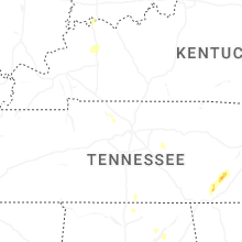


Connect with Interactive Hail Maps