

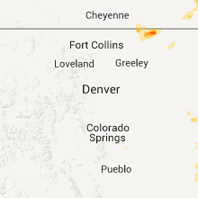
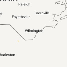
Hail Map for Thursday, August 4, 2011

Number of Impacted Households on 8/4/2011
0
Impacted by 1" or Larger Hail
0
Impacted by 1.75" or Larger Hail
0
Impacted by 2.5" or Larger Hail
Square Miles of Populated Area Impacted on 8/4/2011
0
Impacted by 1" or Larger Hail
0
Impacted by 1.75" or Larger Hail
0
Impacted by 2.5" or Larger Hail


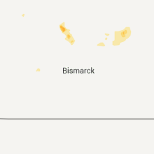


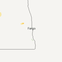


Cities Most Affected by Hail Storms of 8/4/2011
| Hail Size | Demographics of Zip Codes Affected | ||||||
|---|---|---|---|---|---|---|---|
| City | Count | Average | Largest | Pop Density | House Value | Income | Age |
| Goodland, KS | 2 | 1.75 | 1.75 | 9 | $65k | $33.1k | 41.5 |
| Grant, AL | 1 | 1.75 | 1.75 | 80 | $81k | $33.8k | 40.5 |
| Max, ND | 1 | 1.75 | 1.75 | 2 | $32k | $29.8k | 38.1 |
| Heavener, OK | 1 | 1.75 | 1.75 | 27 | $43k | $25.6k | 32.0 |
| Clifford, ND | 1 | 1.75 | 1.75 | 2 | $43k | $40.3k | 41.7 |
Hail and Wind Damage Spotted on 8/4/2011
Filter by Report Type:Hail ReportsWind Reports
States Impacted
Alabama, North Carolina, Mississippi, Kansas, Arizona, Utah, Tennessee, Nebraska, Montana, Idaho, Arkansas, Oklahoma, South Carolina, Georgia, North Dakota, ColoradoAlabama
| Local Time | Report Details |
|---|---|
| 4:00 PM UTC | Trees down and barns damaged near the intersection of al hwy 176 and county road 55 in the mount vernon community in dekalb county AL, 57.4 miles SSW of Chattanooga, TN |
| 4:14 PM UTC | Trees down on county road 88 at pine ridge. timing based on rada in dekalb county AL, 50.5 miles SSW of Chattanooga, TN |
| 4:20 PM UTC | Golf Ball sized hail reported near Grant, AL, 64.2 miles WSW of Chattanooga, TN, time estimated from radar |
| 4:25 PM UTC | Quarter sized hail reported near Baileyton, AL, 52.3 miles NNE of Birmingham, AL |
| 6:55 PM UTC | Trees down in glencoe along air depot road and college street. one tree fell on a house. also a tin roof was damage in etowah county AL, 59.1 miles ENE of Birmingham, AL |
| 9:05 PM UTC | Many trees down across marion count in marion county AL, 48.7 miles SSW of Florence, AL |
| 9:15 PM UTC | Several trees down and large section of roof from a shed blown away. estimated wind gust up to 70 mp in franklin county AL, 33.7 miles S of Florence, AL |
| 9:30 PM UTC | Many trees down across lamar county... especially north of verno in lamar county AL, 49 miles NE of Starkville, MS |
| 11:34 PM UTC | At least one tree and several tree limbs down near downtown mobil in mobile county AL, 2.2 miles WSW of Mobile, AL |
North Carolina
| Local Time | Report Details |
|---|---|
| 4:35 PM UTC | Power company reported that a tree had knocked down power lines at the intersection of morgan hill road and martins creek roa in cherokee county NC, 60.9 miles S of Knoxville, TN |
Mississippi
| Local Time | Report Details |
|---|---|
| 8:00 PM UTC | Trees and powerlines dow in tishomingo county MS, 39.8 miles WSW of Florence, AL |
| 8:00 PM UTC | Trees and powerlines down near belmont cemetary road and natchez trace parkwa in tishomingo county MS, 39.8 miles WSW of Florence, AL |
| 8:09 PM UTC | Trees down near red bull road...near the tishimingo and itawamba county lin in tishomingo county MS, 38.2 miles SW of Florence, AL |
| 8:09 PM UTC | Trees down near red bull road...near the tishomingo and itawamba county lin in tishomingo county MS, 38.2 miles SW of Florence, AL |
| 8:30 PM UTC | Shingles off several roofs in his neighborhood. a tree was also snapped in half. power is out in the area as wel in lee county MS, 63.4 miles N of Starkville, MS |
| 8:30 PM UTC | Trees and powerlines down on front and pyle streets in saltillo. on cartwright street...a tree fell on a house. metal was blown off of several roof in lee county MS, 63.4 miles N of Starkville, MS |
| 8:30 PM UTC | Trees and powerlines down on front and pyle streets in saltillo. on cartwright street...a tree fell on a house. unknown injuries at this tim in lee county MS, 63.4 miles N of Starkville, MS |
| 8:37 PM UTC | Numerous trees down in tupelo. an awning was blown off a busines in lee county MS, 54.9 miles N of Starkville, MS |
| 9:15 PM UTC | Trees and powerlines down across benton county. reports of damage began around 415 p in benton county MS, 54 miles ESE of Memphis, TN |
| 9:20 PM UTC | A couple of trees down on hidgon road...east of the town of higdo in marshall county MS, 47.5 miles ESE of Memphis, TN |
| 9:30 PM UTC | A few trees down on coontail road around lake monroe near the town of wre in monroe county MS, 36.8 miles NNE of Starkville, MS |
| 9:45 PM UTC | Tree downed in city of caledoni in lowndes county MS, 31.5 miles ENE of Starkville, MS |
| 10:05 PM UTC | A few trees and powerlines down in the town of new alban in union county MS, 71.6 miles N of Starkville, MS |
| 10:10 PM UTC | A few trees were down on hwy 72 in the town of corint in alcorn county MS, 48.9 miles WNW of Florence, AL |
| 10:22 PM UTC | Trees down along hwy 45 and county road 516 between wheeler and baldwyn. time is estimate in prentiss county MS, 54.8 miles WSW of Florence, AL |
| 10:30 PM UTC | Trees and powerlines down across alcorn county. a roof was blown off a mobile home on county road 573. half of a building had collapsed in rienz in alcorn county MS, 48.7 miles W of Florence, AL |
| 10:30 PM UTC | Trees and powerlines down across the county. one house was on fire due to lightnin in lee county MS, 63.4 miles N of Starkville, MS |
| 10:35 PM UTC | Widespread trees down across the southern part of pontotoc count in pontotoc county MS, 46.8 miles NNW of Starkville, MS |
| 10:40 PM UTC | Numerous trees down in tupelo. an awning was blown off a busines in lee county MS, 54.9 miles N of Starkville, MS |
| 10:45 PM UTC | 3 inch tree limbs down on powerlines along hwy 363 in mantachi in itawamba county MS, 57.1 miles SW of Florence, AL |
| 10:55 PM UTC | Trees and powerlines down reported in northwest portion of the count in calhoun county MS, 55.2 miles NW of Starkville, MS |
| 10:55 PM UTC | Trees and powerlines down along hwy 32 west of bruce. report relayed by local medi in calhoun county MS, 47.9 miles NW of Starkville, MS |
| 11:30 PM UTC | Trees and powerlines reported down in vardaman. trees and powerlines also reported down across most of calhoun count in calhoun county MS, 35.5 miles NW of Starkville, MS |
| 12:00 AM UTC | Numerous trees downed around the city of eupora and webster count in webster county MS, 27.4 miles W of Starkville, MS |
| 12:15 AM UTC | Tree fell on house in choctaw county MS, 27 miles W of Starkville, MS |
| 12:25 AM UTC | Multiple trees were downed across choctaw count in choctaw county MS, 25.2 miles WSW of Starkville, MS |
| 1:40 AM UTC | Tree fell alongside apartment complex causing some damage to balconies. time of occurence is estimate in lee county MS, 58.2 miles WSW of Florence, AL |
| 1:40 AM UTC | Tree fell on apartment complex. residents trapped inside. injuries are unknown at this time. time of occurence is estimate in lee county MS, 58.2 miles WSW of Florence, AL |
Kansas
| Local Time | Report Details |
|---|---|
| 8:26 PM UTC | Quarter sized hail reported near McDonald's, KS, 35.1 miles NNW of Colby, KS |
| 9:10 PM UTC | 3/4 inch hail also falling at time of repor in rawlins county KS, 28.9 miles N of Colby, KS |
| 11:10 PM UTC | Storm damage reported in ness county KS, 46.8 miles NE of Garden City, KS |
| 12:45 AM UTC | Storm damage reported in hamilton county KS, 42 miles W of Garden City, KS |
| 1:15 AM UTC | Golf Ball sized hail reported near Goodland, KS, 35.8 miles W of Colby, KS |
| 1:15 AM UTC | Golf Ball sized hail reported near Goodland, KS, 41.2 miles WSW of Colby, KS, corrected for location |
| 2:01 AM UTC | Storm damage reported in wallace county KS, 58.6 miles SW of Colby, KS |
| 2:25 AM UTC | Quarter sized hail reported near Goodland, KS, 40.5 miles WSW of Colby, KS |
| 6:20 AM UTC | A hayshed was destroyed by the storms which swept through overnigh in grant county KS, 26.8 miles SW of Garden City, KS |
| 6:25 AM UTC | Tree downed which damaged buildin in chautauqua county KS, 60.8 miles SE of Wichita, KS |
| 7:31 AM UTC | 50 to 60 mph wind gust in barton county KS, 45.2 miles SE of Hays, KS |
| 8:00 AM UTC | Storm damage reported in ellsworth county KS, 53.5 miles ESE of Hays, KS |
| 8:15 AM UTC | Storm damage reported in ellsworth county KS, 59.4 miles ESE of Hays, KS |
| 8:48 AM UTC | Storm damage reported in cloud county KS, 63.6 miles WNW of Manhattan, KS |
| 8:55 AM UTC | Storm damage reported in cloud county KS, 63.7 miles WNW of Manhattan, KS |
| 9:26 AM UTC | 7 to 9 inch tree limbs downed at 9th and dexte in clay county KS, 33 miles WNW of Manhattan, KS |
| 9:28 AM UTC | Shook vehicle pretty good with a few small limbs dow in clay county KS, 40.6 miles NW of Manhattan, KS |
| 9:57 AM UTC | Tree limbs down causing transformer to blow u in riley county KS, 0.4 miles W of Manhattan, KS |
| 10:12 AM UTC | Mailboxes blown down. reported by wibw t in pottawatomie county KS, 16.7 miles NNE of Manhattan, KS |
Arizona
| Local Time | Report Details |
|---|---|
| 9:26 PM UTC | Storm damage reported in santa cruz county AZ, 54.9 miles S of Tucson, AZ |
Utah
| Local Time | Report Details |
|---|---|
| 9:30 PM UTC | Ping Pong Ball sized hail reported near Salt Lake City, UT, 9.9 miles SW of Salt Lake City, UT |
| 9:40 PM UTC | Quarter sized hail reported near West Valley City, UT, 8 miles SW of Salt Lake City, UT |
Tennessee
| Local Time | Report Details |
|---|---|
| 9:40 PM UTC | A couple of trees down across the southeastern portion of hardeman count in hardeman county TN, 67.2 miles WNW of Florence, AL |
| 9:45 PM UTC | Trees down across mainly eastern portions of mcnairy count in mcnairy county TN, 62.3 miles WNW of Florence, AL |
Nebraska
| Local Time | Report Details |
|---|---|
| 10:07 PM UTC | Quarter sized hail reported near Harrison, NE, 38.8 miles NNW of Scottsbluff, NE |
| 12:42 AM UTC | Storm damage reported in box butte county NE, 44 miles ENE of Scottsbluff, NE |
Montana
| Local Time | Report Details |
|---|---|
| 10:08 PM UTC | Quarter sized hail reported near Glendive, MT, 79 miles SW of Williston, ND, mainly pea size hail with quarter size hail...heavy rain |
| 10:08 PM UTC | Quarter sized hail reported near Glendive, MT, 72.6 miles SSW of Williston, ND, mainly pea size hail with quarter size...heavy rain |
| 10:22 PM UTC | Ping Pong Ball sized hail reported near Glendive, MT, 79 miles SW of Williston, ND |
| 10:35 PM UTC | Quarter sized hail reported near Glendive, MT, 55.3 miles NE of Miles City, MT, dime to quarter size |
| 11:10 PM UTC | Quarter sized hail reported near Glendive, MT, 72.7 miles NE of Miles City, MT, mainly pea size hail with some penny and quarter size. |
| 11:16 PM UTC | Quarter sized hail reported near Glendive, MT, 72.6 miles SSW of Williston, ND, mainly pea size hail with quarter size...heavy rain |
| 12:02 AM UTC | Estimated 60 to 70 mph wind gust with heavy rain and pea sized hai in wibaux county MT, 81.3 miles SSW of Williston, ND |
Idaho
| Local Time | Report Details |
|---|---|
| 10:10 PM UTC | Quarter sized hail reported near Fort Hall, ID, 37.5 miles SSW of Idaho Falls, ID |
| 10:10 PM UTC | A few pieces of vinyl s in lemhi county ID, 21.9 miles S of Salmon, ID |
| 10:15 PM UTC | Quarter sized hail reported near Fort Hall, ID, 39.1 miles SSW of Idaho Falls, ID, 0.50 inch of rain fell in 10 minutes. |
| 12:22 AM UTC | Quarter sized hail reported near American Falls, ID, 60.9 miles SW of Idaho Falls, ID |
Arkansas
| Local Time | Report Details |
|---|---|
| 10:15 PM UTC | Trees and power lines down in the city due to strong thunderstorm wind in dallas county AR, 64.5 miles S of Little Rock, AR |
| 10:15 PM UTC | Power pole blown down on morrow street near the mena regional hospita in polk county AR, 49 miles NNW of Nashville, AR |
Oklahoma
| Local Time | Report Details |
|---|---|
| 10:25 PM UTC | Golf Ball sized hail reported near Heavener, OK, 56.3 miles SSW of Fort Smith, AR, a lot of hail. very windy. |
| 10:45 PM UTC | Quarter sized hail reported near Heavener, OK, 56.3 miles SSW of Fort Smith, AR |
| 12:05 AM UTC | Very strong winds flipped an airplane at the local airpor in latimer county OK, 59.4 miles NE of Atoka, OK |
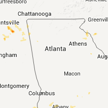
South Carolina
| Local Time | Report Details |
|---|---|
| 10:30 PM UTC | Tree down in anderson in anderson county SC, 21.6 miles S of Greenville, SC |
| 10:32 PM UTC | Tress and power lines down and peas size hai in beaufort county SC, 34.8 miles NE of Savannah, GA |
| 10:45 PM UTC | A few trees down around belton...two on forest lane on the southwest side...a good size tree at the fire department down...and he knew of a few more that nobody called in anderson county SC, 22.7 miles SSE of Greenville, SC |
| 10:55 PM UTC | Trees down on watson road just ne of trento in edgefield county SC, 20.5 miles NNE of Augusta, GA |
| 11:30 PM UTC | Large tree down along farrow parkway. relayed by medi in horry county SC, 69.2 miles WSW of Wilmington, NC |
Georgia
| Local Time | Report Details |
|---|---|
| 10:40 PM UTC | 1 power pole down off reed creek school rd ne of hartwel in hart county GA, 31 miles SSW of Greenville, SC |
| 10:42 PM UTC | A small tree fell in the storm within the milltown campground park area. this is a little south of the previously reported power pole down off reed creek school road by in hart county GA, 35.2 miles SSW of Greenville, SC |
North Dakota
| Local Time | Report Details |
|---|---|
| 12:05 AM UTC | Roof blown off of hous in golden valley county ND, 86.6 miles SSW of Williston, ND |
| 12:12 AM UTC | Sustained winds at 39 mp in golden valley county ND, 86.6 miles SSW of Williston, ND |
| 12:20 AM UTC | Golf Ball sized hail reported near Clifford, ND, 43 miles NW of Fargo, ND, golf ball sized hail 1 mile se of clifford. |
| 12:25 AM UTC | Turned small shed and camper ove in golden valley county ND, 85.4 miles S of Williston, ND |
| 4:59 AM UTC | Golf Ball sized hail reported near Max, ND, 28.7 miles S of Minot, ND, relayed from the minot air force base...hail occurred at their delta complex. |
Colorado
| Local Time | Report Details |
|---|---|
| 1:10 AM UTC | 1 inch diameter tree limbs blown dow in kiowa county CO, 71.3 miles WNW of Garden City, KS |
| 1:36 AM UTC | Storm damage reported in prowers county CO, 95.6 miles W of Garden City, KS |
| 1:36 AM UTC | Storm damage reported in prowers county CO, 99.4 miles W of Garden City, KS |
| 1:45 AM UTC | Storm damage reported in prowers county CO, 99.4 miles W of Garden City, KS |
Connect with Interactive Hail Maps