

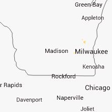
Hail Map for Tuesday, August 7, 2012

Number of Impacted Households on 8/7/2012
0
Impacted by 1" or Larger Hail
0
Impacted by 1.75" or Larger Hail
0
Impacted by 2.5" or Larger Hail
Square Miles of Populated Area Impacted on 8/7/2012
0
Impacted by 1" or Larger Hail
0
Impacted by 1.75" or Larger Hail
0
Impacted by 2.5" or Larger Hail


Cities Most Affected by Hail Storms of 8/7/2012
| Hail Size | Demographics of Zip Codes Affected | ||||||
|---|---|---|---|---|---|---|---|
| City | Count | Average | Largest | Pop Density | House Value | Income | Age |
| Clayton, OK | 2 | 1.75 | 1.75 | 3 | $34k | $20.9k | 43.2 |
| Wolbach, NE | 1 | 1.75 | 1.75 | 2 | $28k | $27.5k | 44.5 |
| Saint Paul, NE | 1 | 1.75 | 1.75 | 18 | $69k | $33.0k | 42.3 |
Hail and Wind Damage Spotted on 8/7/2012
Filter by Report Type:Hail ReportsWind Reports
States Impacted
Oklahoma, Texas, Georgia, Iowa, Arkansas, Kansas, Wisconsin, South Dakota, Nebraska, Louisiana, Colorado, Arizona, OhioOklahoma
| Local Time | Report Details |
|---|---|
| 1:30 PM CDT | Numerous large tree limbs blown down in and near stanle in pushmataha county OK, 39 miles ENE of Atoka, OK |
| 1:30 PM CDT | Golf Ball sized hail reported near Clayton, OK, 39 miles ENE of Atoka, OK, marble to golf ball size hail reported. |
| 1:45 PM CDT | Golf Ball sized hail reported near Clayton, OK, 39 miles ENE of Atoka, OK, marble to golf ball size hail reported. |
| 2:55 PM CDT | Quarter sized hail reported near Bethel, OK, 68.4 miles E of Atoka, OK, at grocery store in battiest |
| 3:40 PM CDT | Storm damage reported in pottawatomie county OK, 47.5 miles SE of Oklahoma City, OK |
| 4:55 PM CDT | Storm damage reported in grady county OK, 32.2 miles WSW of Oklahoma City, OK |
| 5:05 PM CDT | Trees down on road in haskell county OK, 50 miles WSW of Fort Smith, AR |
| 5:30 PM CDT | Several trees down... wind estimated 60 to 70 mp in pittsburg county OK, 56.7 miles WSW of Fort Smith, AR |
| 5:50 PM CDT | Multiple power poles downed near 164th and macarthur blvd. some poles fell into home in oklahoma county OK, 13.5 miles NNW of Oklahoma City, OK |
| 6:05 PM CDT | Storm damage reported in beaver county OK, 67.8 miles WNW of Woodward, OK |
| 7:01 PM CDT | Nw 112th/nw cache rd 5-6 pwr poles dow in comanche county OK, 47.9 miles N of Wichita Falls, TX |
| 7:01 PM CDT | Nw 112th/nw cache rd roof damage/windows blown ou in comanche county OK, 47.9 miles N of Wichita Falls, TX |
Texas
| Local Time | Report Details |
|---|---|
| 2:27 PM CDT | Outbuilding dest in grayson county TX, 60.5 miles N of Dallas, TX |
| 4:55 PM CDT | 62-mph wind gust at clark field (ksep) in erath county TX, 81.6 miles NNW of Killeen, TX |
| 5:45 PM CDT | Tree blown down and other large branches blown down near kbtx tv in college station. time approximat in brazos county TX, 80.7 miles NW of Houston, TX |
| 6:30 PM CDT | Damage to solar panels with unknown wind speeds in potter county TX, 3 miles NW of Amarillo, TX |
| 6:52 PM CDT | Trees down on fm 2863 in nacogdoches county TX, 17.2 miles N of Lufkin, TX |
| 6:55 PM CDT | Quarter sized hail reported near Chandler, TX, 79 miles ESE of Dallas, TX |
| 7:02 PM CDT | Quarter sized hail reported near Chandler, TX, 81.2 miles NNW of Lufkin, TX, quarter hail near chandler. |
| 7:19 PM CDT | Quarter sized hail reported near Hutchins, TX, 10.7 miles SSE of Dallas, TX, quarter hail at i45 and wintergreen |
| 7:34 PM CDT | Telephone lines blown down at intersection of highway 342 and wintergree in dallas county TX, 11 miles S of Dallas, TX |
| 7:38 PM CDT | With heavy rain and limited visibility in randall county TX, 20 miles SSE of Amarillo, TX |
| 7:51 PM CDT | Damage reported to a center pivot system in wheeler county TX, 75.9 miles N of Childress, TX |
| 9:05 PM CDT | Estimated 60 mph winds at alanreed travel center at mile marker 135 on i-40 in gray county TX, 61.4 miles NNW of Childress, TX |
Georgia
| Local Time | Report Details |
|---|---|
| 3:40 PM EDT | Large tree down on hwy 82 and co rd 212 in atkinson county GA, 14.2 miles S of Douglas, GA |
| 4:24 PM EDT | Thunderstorm winds blew down power lines near the intersection of sam green and herbert holton roads. time of event was estimated from radar dat in tattnall county GA, 57.2 miles W of Savannah, GA |
| 4:47 PM EDT | Liberty county dispatch reported several trees and power lines down. one tree was on a hous in liberty county GA, 25 miles SW of Savannah, GA |
| 5:15 PM EDT | Quarter sized hail reported near Richmond Hill, GA, 15.7 miles SW of Savannah, GA, trained spotter reported quarter size hail in richmond hill near the intersection of highways 17 and 144. |
| 5:21 PM EDT | A tree fell into the right lane of interstate 95 southbound near mile marker 9 in chatham county GA, 11.5 miles WSW of Savannah, GA |
Iowa
| Local Time | Report Details |
|---|---|
| 3:15 PM CDT | Resident reports siding torn off of house and an outbuilding...windows blown out of the house...and power is out. relayed by county dispatch center. delayed report. tim in madison county IA, 36.5 miles SW of Des Moines, IA |
| 9:18 PM CDT | Half Dollar sized hail reported near Crescent, IA, 7.6 miles N of Omaha, NE, near the mormon bridge. |
| 9:30 PM CDT | 4 power poles blown down. crops flatten. delayed report in pottawattamie county IA, 15.4 miles NNW of Omaha, NE |
Arkansas
| Local Time | Report Details |
|---|---|
| 3:30 PM CDT | Trees reported dow in polk county AR, 46.8 miles NW of Nashville, AR |
| 3:30 PM CDT | Quarter sized hail reported near Cove, AR, 46.8 miles NW of Nashville, AR |
| 4:50 PM CDT | Tree down near highway 282 in crawford county AR, 9.5 miles NE of Fort Smith, AR |
Kansas
| Local Time | Report Details |
|---|---|
| 3:43 PM CDT | Minor roof damage was reported at the methodist church in mullinville. several windows were also cracked or broke in kiowa county KS, 79.8 miles N of Woodward, OK |
| 6:39 PM CDT | Law enforcement reports power poles snapped in half approximately 6 miles east and 1 mile north of great bend. time is estimated based on rada in barton county KS, 29.7 miles ESE of Hays, KS |
Wisconsin
| Local Time | Report Details |
|---|---|
| 4:03 PM CDT | Ping Pong Ball sized hail reported near Kewaskum, WI, 66.9 miles ENE of Madison, WI, measured hail 1 and 1/4 to 1 and 1/2 inch in diameter. minor damage to trees...outdoor equipment...and vehicles. time estimated. |
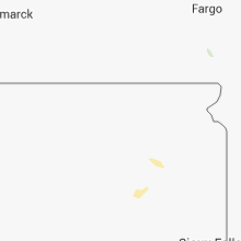
South Dakota
| Local Time | Report Details |
|---|---|
| 3:15 PM MDT | Ping Pong Ball sized hail reported near Scenic, SD, 48.7 miles ESE of Rapid City, SD |
| 3:35 PM MDT | Quarter sized hail reported near Scenic, SD, 44.2 miles ESE of Rapid City, SD |
| 3:15 AM CDT | Storm damage reported in beadle county SD, 74.9 miles S of Aberdeen, SD |
Nebraska
| Local Time | Report Details |
|---|---|
| 5:20 PM CDT | Quarter sized hail reported near Wolbach, NE, 32.8 miles N of Grand Island, NE, hail up to the size of quarters started falling around 520 pm...and was still falling. |
| 5:41 PM CDT | Golf Ball sized hail reported near Wolbach, NE, 32.8 miles N of Grand Island, NE |
| 5:47 PM CDT | Quarter sized hail reported near Wolbach, NE, 32.8 miles N of Grand Island, NE, quarter size hail currently falling. ground is completely covered and visibility is poor due to hail. |
| 5:56 PM CDT | Quarter sized hail reported near St Edward, NE, 51.1 miles NNE of Grand Island, NE |
| 6:00 PM CDT | Quarter sized hail reported near Wolbach, NE, 32.5 miles N of Grand Island, NE, hail up to the size of quarters started near 6 pm and fell for 10 to 15 minutes. |
| 5:00 PM MDT | Power pole broken in half in imperial. power outage continues for the city of imperial. power was also knocked out at the automated surface observing station at the imp in chase county NE, 62.6 miles SW of North Platte, NE |
| 6:01 PM CDT | Golf Ball sized hail reported near Wolbach, NE, 35.2 miles N of Grand Island, NE, golf ball sized shattered windshield 3 nw of wolbach. |
| 5:05 PM MDT | Estimated 50 to 60 mph wind gusts as thunderstorm passed through imperia in chase county NE, 62.6 miles SW of North Platte, NE |
| 6:15 PM CDT | Ping Pong Ball sized hail reported near Wolbach, NE, 31.9 miles N of Grand Island, NE, hail up the size of ping pong was reported. |
| 6:26 PM CDT | Quarter sized hail reported near St Edward, NE, 51.1 miles NNE of Grand Island, NE, corrected time. |
| 6:38 PM CDT | Quarter sized hail reported near Hayes Center, NE, 45.3 miles SSW of North Platte, NE, quarter size hail slowly got smaller. ground was white. 0.75 of an inch of rainfall reported. |
| 7:00 PM CDT | Golf Ball sized hail reported near St Paul, NE, 26.5 miles NNW of Grand Island, NE, hail up to the size of golf balls started near 7 pm and was still ongoing. |
| 7:00 PM CDT | Quarter sized hail reported near Elba, NE, 27.3 miles NNW of Grand Island, NE, mostly small hail reported...but there were a few quarter size hail stones. |
| 7:24 PM CDT | Pea size hail als in cass county NE, 16.8 miles SSW of Omaha, NE |
| 7:48 PM CDT | Tree limbs breaking. no size indicate in sarpy county NE, 10.6 miles S of Omaha, NE |
| 7:52 PM CDT | Quarter sized hail reported near Bellevue, NE, 10.4 miles S of Omaha, NE, winds estimated up to 60 mph. |
| 9:30 PM CDT | 4 power poles blown down. crops flatten. delayed report in washington county NE, 15 miles NNW of Omaha, NE |
Louisiana
| Local Time | Report Details |
|---|---|
| 5:21 PM CDT | Several trees down in natchitoches in natchitoches county LA, 64.4 miles SE of Shreveport, LA |
| 5:23 PM CDT | Tree down on paul jordan road in natchitoches county LA, 64.2 miles SE of Shreveport, LA |
Colorado
| Local Time | Report Details |
|---|---|
| 6:45 PM MDT | Quarter sized hail reported near Holly, CO, 68.2 miles W of Garden City, KS, hail to near quarter size...60 mph winds and very heavy rain estimated by cdot workers on highway 89 near holly. |
| 7:32 PM MDT | Storm damage reported in kit carson county CO, 65 miles SSE of Yuma, CO |
Arizona
| Local Time | Report Details |
|---|---|
| 9:41 PM MST | Storm damage reported in cochise county AZ, 48.7 miles WNW of Douglas, AZ |
| 9:45 PM MST | Extensive roof damage to elementary school in cochise county AZ, 50.5 miles WNW of Douglas, AZ |
Ohio
| Local Time | Report Details |
|---|---|
| 12:45 AM EDT | Limbs and tree in montgomery county OH, 45.9 miles NNE of Cincinnati, OH |
Connect with Interactive Hail Maps