

Hail Map for Wednesday, August 8, 2012

Number of Impacted Households on 8/8/2012
0
Impacted by 1" or Larger Hail
0
Impacted by 1.75" or Larger Hail
0
Impacted by 2.5" or Larger Hail
Square Miles of Populated Area Impacted on 8/8/2012
0
Impacted by 1" or Larger Hail
0
Impacted by 1.75" or Larger Hail
0
Impacted by 2.5" or Larger Hail


Cities Most Affected by Hail Storms of 8/8/2012
| Hail Size | Demographics of Zip Codes Affected | ||||||
|---|---|---|---|---|---|---|---|
| City | Count | Average | Largest | Pop Density | House Value | Income | Age |
| Bellevue, NE | 2 | 1.88 | 2.00 | 1325 | $98k | $44.5k | 35.9 |
| Lohman, MO | 1 | 1.75 | 1.75 | 40 | $131k | $49.8k | 43.8 |
| Greenwood, NE | 1 | 1.75 | 1.75 | 15 | $86k | $46.0k | 41.8 |
| Jameson, MO | 1 | 1.75 | 1.75 | 5 | $30k | $23.5k | 47.2 |
Hail and Wind Damage Spotted on 8/8/2012
Filter by Report Type:Hail ReportsWind Reports
States Impacted
North Carolina, Arkansas, New York, Texas, Oklahoma, Iowa, South Carolina, Ohio, Missouri, Pennsylvania, Virginia, Kansas, Nebraska, Illinois, Montana, Minnesota, Florida, Arizona, Louisiana, West Virginia, IndianaNorth Carolina
| Local Time | Report Details |
|---|---|
| 1:00 PM EDT | One tree down near intersection of massey deal rd and old mountain r in iredell county NC, 40.1 miles NNW of Charlotte, NC |
| 1:50 PM EDT | Tree down that is blocking hancock road in rockingham county NC, 60.2 miles S of Roanoke, VA |
| 2:16 PM EDT | Half Dollar sized hail reported near East Bend, NC, 72.1 miles N of Charlotte, NC, half dollar size hail on lime rock road...hail occurred for about 30 minutes |
| 2:20 PM EDT | Trees down on shearers roa in iredell county NC, 22.6 miles N of Charlotte, NC |
| 2:28 PM EDT | Tree down along barnes street close to the intersection of us route 29 in rockingham county NC, 66.9 miles SSE of Roanoke, VA |
| 3:10 PM EDT | Quarter sized hail reported near Morganton, NC, 63.1 miles SSE of Bristol, TN |
| 3:20 PM EDT | Tree down at nc61 and cone club road... time estimated by radar in guilford county NC, 55.6 miles WNW of Raleigh, NC |
| 3:20 PM EDT | Tree down at nc61 and kivette house road... time estimated by radar in guilford county NC, 55.6 miles WNW of Raleigh, NC |
| 3:26 PM EDT | Broadcast media reported large tree limbs blown down in the plaza are in mecklenburg county NC, 5 miles E of Charlotte, NC |
| 3:38 PM EDT | Tree down in elon... time estimated by radar in alamance county NC, 53.2 miles WNW of Raleigh, NC |
| 4:07 PM EDT | Trees down blocking the east bound lanes of interstate 40 and more trees down blocking goose creek road which is just south of the interstat in mcdowell county NC, 64.1 miles NNE of Greenville, SC |
| 4:30 PM EDT | Two trees blown down. time estimate in randolph county NC, 57.8 miles ENE of Charlotte, NC |
| 4:30 PM EDT | Quarter sized hail reported near Marion, NC, 62.7 miles NNE of Greenville, SC, public reported quarter size hail in the glenwood community. |
| 4:40 PM EDT | Em reports numerous trees blown down in the glenwood communit in mcdowell county NC, 61.5 miles NNE of Greenville, SC |
| 4:40 PM EDT | Quarter sized hail reported near Henderson, NC, 42.4 miles NNE of Raleigh, NC |
| 4:55 PM EDT | Powerlines down at route 39 and stagecoach road. time estimated by rada in vance county NC, 43.5 miles NNE of Raleigh, NC |
| 4:55 PM EDT | Outflow from a storm brought down two large limbs on interstate 85 and local fire department was sent out to remov in cleveland county NC, 30.7 miles W of Charlotte, NC |
| 5:10 PM EDT | Quarter sized hail reported near Henderson, NC, 47.4 miles NNE of Raleigh, NC, 1 inch hail |
| 5:21 PM EDT | Tree down on a house... time estimated by radar in lee county NC, 36.4 miles SW of Raleigh, NC |
| 5:27 PM EDT | 911 center had several reports of trees down and power outages in the city of sanford. there were six additional reports of trees down in the count in lee county NC, 36.9 miles SW of Raleigh, NC |
| 5:29 PM EDT | Tree down on a house... time estimated by radar in stanly county NC, 42.2 miles ENE of Charlotte, NC |
| 5:32 PM EDT | Tree down... time estimated by radar in montgomery county NC, 46.1 miles ENE of Charlotte, NC |
| 5:46 PM EDT | Multiple reports of wires down in louisburg including malcolm neal path and ridge road. time estimated by radra in franklin county NC, 32.9 miles NE of Raleigh, NC |
| 5:55 PM EDT | Telephone lines down in stanly county NC, 37.5 miles ENE of Charlotte, NC |
| 6:59 PM EDT | Tree down on durant road... time estimated by radar in wake county NC, 8.6 miles N of Raleigh, NC |
| 7:09 PM EDT | Trees down on power lines on pinevew drive... time estimated by radar in wake county NC, 14.5 miles NNE of Raleigh, NC |
| 7:27 PM EDT | Tree down across knightdale blvd in wake county NC, 8.7 miles E of Raleigh, NC |
| 7:51 PM EDT | Tree down on thanksgiving fire road... time estimated by radar in johnston county NC, 20.3 miles ESE of Raleigh, NC |
Arkansas
| Local Time | Report Details |
|---|---|
| 12:15 PM CDT | Numerous trees down in sprindale. large swingset and trampoline also destroye in washington county AR, 57.9 miles NNE of Fort Smith, AR |
| 3:20 PM CDT | Tree limbs and trees were blown dow in hot spring county AR, 37.9 miles NE of Nashville, AR |
| 3:20 PM CDT | Quarter sized hail reported near Amity, AR, 37.4 miles NE of Nashville, AR |
| 4:15 PM CDT | Several trees were blown down along hwy 53 north of gurdon near smithto in clark county AR, 41.2 miles E of Nashville, AR |
| 5:40 PM CDT | A privacy fence along dave ward drive was blown ove in faulkner county AR, 25.6 miles NNW of Little Rock, AR |
| 5:52 PM CDT | Numerous power lines are down across the north little rock are in pulaski county AR, 3 miles NNE of Little Rock, AR |
| 6:01 PM CDT | Large trees are down on spring stree in pulaski county AR, 1.3 miles SSW of Little Rock, AR |
New York
| Local Time | Report Details |
|---|---|
| 2:19 PM EDT | Tree down with an injury at lazy lake camp ground... multiple wires down in upper and lower cambri in niagara county NY, 20.5 miles N of Buffalo, NY |
| 2:44 PM EDT | Several large trees blown down in niagara county NY, 29.5 miles NE of Buffalo, NY |
Texas
| Local Time | Report Details |
|---|---|
| 1:40 PM CDT | Several trees (size unknown at this time) and power lines blown down in china spring in mclennan county TX, 43.9 miles NNE of Killeen, TX |
| 3:05 PM CDT | Tree down fm 2015 north of loop 323 in smith county TX, 76.2 miles NNW of Lufkin, TX |
| 3:40 PM CDT | Trees down and part of a barn blown into road... blocking fm 837 near springfield in anderson county TX, 77.4 miles NW of Lufkin, TX |
| 4:00 PM CDT | Trees down west of whitehouse in smith county TX, 68.4 miles NNW of Lufkin, TX |
| 4:30 PM CDT | Trees down in cherokee county TX, 57.7 miles NNW of Lufkin, TX |
| 4:30 PM CDT | Large limbs blocked highway 84 8 miles east of palestin in anderson county TX, 53.5 miles WNW of Lufkin, TX |
| 5:15 PM CDT | Trees down in cherokee county TX, 52.6 miles NW of Lufkin, TX |
| 5:35 PM CDT | Tree down at mile marker 612 on interstate 2 in harrison county TX, 35.2 miles W of Shreveport, LA |
| 5:45 PM CDT | Trees down across 225 in nacogdoches county TX, 31 miles NNW of Lufkin, TX |
| 5:45 PM CDT | Trees down 2 south of marshall on fm 2625 in harrison county TX, 35.2 miles W of Shreveport, LA |
| 7:13 PM CDT | 50 to 60 mph and nickel hail reported by public near bear creek community church in parker county TX, 49 miles WSW of Dallas, TX |
| 7:20 PM CDT | Quarter sized hail reported near Cresson, TX, 49 miles WSW of Dallas, TX |
| 8:55 PM CDT | Trees down throughout the western portions of the county in lamar county TX, 52.9 miles SSE of Atoka, OK |
Oklahoma
| Local Time | Report Details |
|---|---|
| 1:59 PM CDT | 3-4 inch diameter tree limbs down. time is radar estimate in pittsburg county OK, 32.2 miles NE of Atoka, OK |
| 2:15 PM CDT | Measured at the eoc in potea in le flore county OK, 25.7 miles SSW of Fort Smith, AR |
| 2:30 PM CDT | Trees down on highway 83 in monro in le flore county OK, 27.2 miles SSW of Fort Smith, AR |
| 2:40 PM CDT | Numerous tree limbs down in le flore county OK, 22.1 miles SW of Fort Smith, AR |
| 2:45 PM CDT | Boat dock flipped at snake creek marina. floating stage damaged with twisted metal framing. 3 pontoon boats overturned. numerous large trees dow in cherokee county OK, 37.4 miles WNW of Fort Smith, AR |
| 3:05 PM CDT | 70 mph wind gust measured at davis fiel in muskogee county OK, 44.5 miles SE of Tulsa, OK |
| 3:10 PM CDT | Trees downed..estimated 60 mph win in le flore county OK, 52.9 miles SSW of Fort Smith, AR |
| 5:10 PM CDT | Trees snapped off and marble size hai in craig county OK, 59.3 miles SSE of Chanute, KS |
| 5:15 PM CDT | Storm damage reported in pottawatomie county OK, 38.2 miles SE of Oklahoma City, OK |
| 5:15 PM CDT | Roof shingels blown off of house in pottawatomie county OK, 38.2 miles SE of Oklahoma City, OK |
| 5:42 PM CDT | Power lines down at highway 270 just west of the indian nations turnpik in pittsburg county OK, 40.9 miles NNE of Atoka, OK |
| 5:50 PM CDT | Metal carport blown onto highway 69 bypas in pittsburg county OK, 42.7 miles NNE of Atoka, OK |
| 5:50 PM CDT | Trees and tree limbs down. time estimated by rada in pittsburg county OK, 42.7 miles NNE of Atoka, OK |
| 6:30 PM CDT | Estimated wind speeds of 60 mph blew trampoline from yard into pasture. time is radar estimate in pittsburg county OK, 27.2 miles NE of Atoka, OK |
| 6:36 PM CDT | Small tree limbs blown down and shingles removed from roof in atoka county OK, 18.8 miles NNE of Atoka, OK |
| 7:10 PM CDT | Storm damage reported in atoka county OK, 7.3 miles NE of Atoka, OK |
| 8:03 PM CDT | Power lines down in downtown boswell. time estimated by rada in choctaw county OK, 28.6 miles SSE of Atoka, OK |
Iowa
| Local Time | Report Details |
|---|---|
| 2:10 PM CDT | Half Dollar sized hail reported near Carroll, IA, 38.8 miles SSE of Storm Lake, IA, nssl shave report |
| 2:28 PM CDT | Quarter sized hail reported near Carroll, IA, 34.9 miles SSE of Storm Lake, IA |
| 2:39 PM CDT | Quarter sized hail reported near Scranton, IA, 54.7 miles SE of Storm Lake, IA |
| 3:08 PM CDT | Delayed public report to kcci. time estimated from radar. many trees down in squirrel hollow park...some damage to park bridge with fallen tree in greene county IA, 42.8 miles NW of Des Moines, IA |
| 3:25 PM CDT | Wind was accompanied by pea to dime hail in boone county IA, 38.5 miles NW of Des Moines, IA |
| 3:50 PM CDT | Quarter sized hail reported near Waukee, IA, 13.3 miles W of Des Moines, IA, off duty nws employee reports quarter sized hail in waukee...also relayed report that strong winds had blown down tents at the waukee farmers market. delayed report. ti |
| 3:53 PM CDT | Storm damage reported in polk county IA, 5.1 miles WNW of Des Moines, IA |
| 3:54 PM CDT | 12 inch diameter trees snapped at base south of the intersection of hickman and 156t in dallas county IA, 11.2 miles W of Des Moines, IA |
| 3:55 PM CDT | Storm damage reported in polk county IA, 8 miles W of Des Moines, IA |
| 3:57 PM CDT | At intersection of 68th and douglas...numerous 2 inch diameter limbs down with winds estimated in excess of 60 mp in polk county IA, 7.1 miles W of Des Moines, IA |
| 3:59 PM CDT | Quarter sized hail reported near Des Moines, IA, 2 miles ENE of Des Moines, IA, trained spotter reports hail ranging up to quarter sized along with strong wind gusts. multiple branches down up to 6-8 inches in diameter. minor hail damage to vehicle |
| 4:02 PM CDT | At kcci studio in polk county IA, 0.7 miles W of Des Moines, IA |
| 4:02 PM CDT | Winds estimated in excess of 70 mph. extreme rainfall rates as wel in polk county IA, 7.1 miles W of Des Moines, IA |
| 4:04 PM CDT | Quarter sized hail reported near Grimes, IA, 10.2 miles WNW of Des Moines, IA, amateur radio operator reported quarter sized hail in grimes. |
| 4:04 PM CDT | Quarter sized hail reported near Urbandale, IA, 7.3 miles WNW of Des Moines, IA |
| 4:06 PM CDT | Storm damage reported in polk county IA, 5.2 miles NW of Des Moines, IA |
| 4:09 PM CDT | Wind accompanied by quarter hail in polk county IA, 6 miles NW of Des Moines, IA |
| 4:11 PM CDT | 65 mph winds estimated at the state fair ground in polk county IA, 3.5 miles ENE of Des Moines, IA |
| 5:30 PM CDT | Rwis site at mason city recorded a wind gust to 66 mp in cerro gordo county IA, 0.2 miles NNE of Mason City, IA |
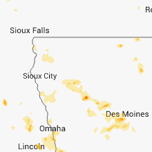
| 6:17 PM CDT | Knocking dead trees over near the missouri river in mills county IA, 17.1 miles SSE of Omaha, NE |
| 6:25 PM CDT | Quarter sized hail reported near Hampton, IA, 23.6 miles S of Mason City, IA |
| 6:42 PM CDT | Tree blown over near the school. some crop damage. spotty power outages reported. time 640-645 p in fremont county IA, 29.2 miles SSE of Omaha, NE |
| 6:52 PM CDT | Wind gust with passage of storms estimated at 60 mph. also pea size hai in fremont county IA, 37 miles SSE of Omaha, NE |
| 6:55 PM CDT | Storm damage reported in floyd county IA, 26.9 miles E of Mason City, IA |
| 7:00 PM CDT | Tree limbs down. penny size hail as wel in fremont county IA, 44.4 miles SSE of Omaha, NE |
| 7:02 PM CDT | Tree damage and power lines down in tow in page county IA, 45.6 miles SE of Omaha, NE |
| 7:26 PM CDT | 6 inch tree limb down. dime size hail as wel in page county IA, 59 miles SE of Omaha, NE |
South Carolina
| Local Time | Report Details |
|---|---|
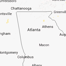
| 3:25 PM EDT | A tree was blown down on welborn rd and another nearby on ireland r in pickens county SC, 4.4 miles NW of Greenville, SC |
| 3:45 PM EDT | Tree down on a power line on mcwhorter rd near highway 13 in pickens county SC, 4.3 miles SSW of Greenville, SC |
| 3:49 PM EDT | Two trees down...one on wyatt road near east church road and the other on mount airy church roa in anderson county SC, 6.2 miles SE of Greenville, SC |
| 4:00 PM EDT | Highway patrol reported a tree blown down at wt wyatt rd and e church rd and another tree on hunt rd in roughly the same are in anderson county SC, 4.9 miles S of Greenville, SC |
| 4:06 PM EDT | Highway patrol reported a tree blown down on mt airy church r in anderson county SC, 6.5 miles SSE of Greenville, SC |
| 4:08 PM EDT | Highway patrol reports a tree down at 3 and 20 rd at highway 8 in anderson county SC, 8.4 miles S of Greenville, SC |
| 4:25 PM EDT | Trees down on my airy church rd in anderson county SC, 6.9 miles SE of Greenville, SC |
| 4:30 PM EDT | Highway patrol reported a tree blown down on i-85 near mile marker 13 and another tree blown down on mountain view rd 7 wsw anderso in anderson county SC, 21.6 miles SSW of Greenville, SC |
| 4:30 PM EDT | Highway patrol reported a tree blown down on mountain view r in anderson county SC, 25.8 miles SSW of Greenville, SC |
| 4:35 PM EDT | Vfd reported five trees down along batchelor drive in cherokee falls communit in cherokee county SC, 41.1 miles WSW of Charlotte, NC |
| 5:40 PM EDT | County comms reports numerous trees blown down south of gaffne in cherokee county SC, 44.5 miles WSW of Charlotte, NC |
| 5:50 PM EDT | One tree fell in union. time based on when an outflow crossed unio in union county SC, 56.3 miles E of Greenville, SC |
| 6:14 PM EDT | One tree down on river road. time based on when the outflow came across the are in union county SC, 55.2 miles SW of Charlotte, NC |
| 6:35 PM EDT | Several trees down in area..off of woods ferry rd in chester county SC, 46.5 miles SW of Charlotte, NC |
| 7:10 PM EDT | Trees down around joann in laurens county SC, 53.2 miles ESE of Greenville, SC |
| 7:15 PM EDT | Report of tree down in roadway on new bridge rd. time estimated by rada in marlboro county SC, 84.2 miles ESE of Charlotte, NC |
| 7:18 PM EDT | Tree down on mcquage farm rd near hwy sc 9. time estimated by rada in marlboro county SC, 83.2 miles ESE of Charlotte, NC |
| 7:22 PM EDT | Tree down at intersection of salem rd and polston rd. time estimated by rada in marlboro county SC, 79.1 miles SE of Charlotte, NC |
| 7:40 PM EDT | Tree down at intersection of oakland rd and country club rd. time estimated by rada in dillon county SC, 82 miles WNW of Wilmington, NC |
Ohio
| Local Time | Report Details |
|---|---|
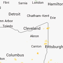
| 3:33 PM EDT | Cluster of trees down near hartsgrove on laskey rd in ashtabula county OH, 39 miles E of Cleveland, OH |
| 3:33 PM EDT | 1 tree down south of jefferson in ashtabula county OH, 49.2 miles ENE of Cleveland, OH |
| 4:15 PM EDT | A lot of large branches down over a quarter mile path and 3 houses had some structural damage from falling branche in medina county OH, 33.5 miles S of Cleveland, OH |
| 4:38 PM EDT | Large tree branches down along alum creek road near howard roa in franklin county OH, 6.9 miles SE of Columbus, OH |
| 4:41 PM EDT | Large tree down blocking one lane of us-33 near hamilton roa in franklin county OH, 8.2 miles SE of Columbus, OH |
| 4:48 PM EDT | Large tree blown down outside groveport city buildin in franklin county OH, 8.9 miles SE of Columbus, OH |
| 5:05 PM EDT | Quarter sized hail reported near Freeport, OH, 67.5 miles WSW of Pittsburgh, PA |
| 7:35 PM EDT | Multiple trees down...power outages in columbiana county OH, 46.6 miles WNW of Pittsburgh, PA |
| 8:00 PM EDT | Multiple trees down...power outages in columbiana county OH, 39.3 miles NW of Pittsburgh, PA |
| 8:05 PM EDT | Multiple trees down...power outages in negley in columbiana county OH, 37.9 miles NW of Pittsburgh, PA |
| 12:35 AM EDT | Storm damage reported in warren county OH, 27.9 miles NNE of Cincinnati, OH |
| 12:43 AM EDT | Small limbs donw just west of waynesville in warren county OH, 36.7 miles NE of Cincinnati, OH |
| 12:50 AM EDT | Trees and large branches down in warren county OH, 27.3 miles NNE of Cincinnati, OH |
| 12:52 AM EDT | Several trees down near oregoni in warren county OH, 33.1 miles NE of Cincinnati, OH |
Missouri
| Local Time | Report Details |
|---|---|
| 2:37 PM CDT | Tree blown down blocking highway 248 near wheelervill in barry county MO, 31.6 miles SW of Springfield, MO |
| 2:48 PM CDT | Quarter sized hail reported near Aurora, MO, 27.5 miles SW of Springfield, MO, local media relayed a viewer report of hail up to quarter sized |
| 2:48 PM CDT | Quarter sized hail reported near Webb City, MO, 64.5 miles SE of Chanute, KS, local media relayed a viewer report of hail up to quarter sized |
| 3:22 PM CDT | Three inch diameter tree limbs were blown dow in greene county MO, 12.4 miles WSW of Springfield, MO |
| 3:30 PM CDT | A power line was blown down. large tree branches blown down near downtown branso in taney county MO, 39.4 miles S of Springfield, MO |
| 3:30 PM CDT | Several power lines down across the city with power outage in greene county MO, 0.6 miles S of Springfield, MO |
| 3:30 PM CDT | Tree down near walnut and kansas expresswa in greene county MO, 2.7 miles WSW of Springfield, MO |
| 3:45 PM CDT | Storm damage reported in greene county MO, 12.1 miles WSW of Springfield, MO |
| 5:05 PM CDT | Quarter sized hail reported near Lockwood, MO, 43.9 miles WNW of Springfield, MO, most of the hail was nickel size with a few up to the size of quarters.report was from the barton county emergency manger. |
| 5:40 PM CDT | Four trees were downed and 5 homes had minor roof damag in newton county MO, 70.6 miles SE of Chanute, KS |
| 6:39 PM CDT | Stj measured wind gust at 54 kts in buchanan county MO, 47.5 miles NNW of Kansas City, MO |
| 7:15 PM CDT | Gust to 55kt measured in platte county MO, 15.4 miles NNW of Kansas City, MO |
| 7:25 PM CDT | 60 mph winds reported downtown at river marke in jackson county MO, 0.3 miles SE of Kansas City, MO |
| 7:27 PM CDT | Trees down....estd 55 mph winds in clay county MO, 7.5 miles N of Kansas City, MO |
| 7:27 PM CDT | Golf Ball sized hail reported near Lohman, MO, 29.2 miles S of Columbia, MO, relayed by jefferson city police department |
| 7:32 PM CDT | Quarter sized hail reported near Lee's Summit, MO, 17.2 miles SE of Kansas City, MO, 15th and todd george |
| 7:40 PM CDT | Power poles snapped between kearney and holt in clay county MO, 24.3 miles NNE of Kansas City, MO |
| 7:41 PM CDT | 55-60 mph wnds excelsior springs in clay county MO, 19.8 miles N of Kansas City, MO |
| 7:45 PM CDT | 4 inch tree snapped at chipmon road and bristle stree in jackson county MO, 17.2 miles SE of Kansas City, MO |
| 7:45 PM CDT | 2-4 inch diameter limbs down in clay county MO, 21.7 miles NE of Kansas City, MO |
| 7:48 PM CDT | Numerous trees down in clay county MO, 10.8 miles NE of Kansas City, MO |
| 7:50 PM CDT | Woods chapel rd and i-70...power outage...45 mph wnds in jackson county MO, 17.3 miles ESE of Kansas City, MO |
| 8:37 PM CDT | Golf Ball sized hail reported near Jameson, MO, 71.1 miles NNE of Kansas City, MO |
| 8:40 PM CDT | Trailer blown off foundation...trees down as wel in daviess county MO, 69.5 miles NNE of Kansas City, MO |
| 8:40 PM CDT | Numerous trees and power lines down...outbuildings damaged...cord ave near 69 highwa in daviess county MO, 70 miles NNE of Kansas City, MO |
| 8:43 PM CDT | 60-70 mph wind gusts estd near coffe in daviess county MO, 74 miles NNE of Kansas City, MO |
| 9:36 PM CDT | Hail ranged in size from nickels to quarters in st. charles county MO, 37.3 miles W of Saint Louis, MO |
| 9:36 PM CDT | Quarter sized hail reported near Wentzville, MO, 37.3 miles W of Saint Louis, MO, hail ranged in size from nickels to quarters |
| 10:00 PM CDT | Tree limb six inches in diameter and 24 feet in length blown down. report approx 1m west of mid rivers mall drive and i-70 in st. charles county MO, 24.5 miles WNW of Saint Louis, MO |
Pennsylvania
| Local Time | Report Details |
|---|---|
| 4:11 PM EDT | 7 to 8 trees down from linesville to conneautville in crawford county PA, 66.7 miles E of Cleveland, OH |
| 4:55 PM EDT | Tree down in cochranton in crawford county PA, 74.7 miles N of Pittsburgh, PA |
| 7:23 PM EDT | Multiple trees and powerlines down in lawrence county PA, 36.6 miles NW of Pittsburgh, PA |
| 7:25 PM EDT | Trees and wires down throughout north beaver tw in lawrence county PA, 41.2 miles NW of Pittsburgh, PA |
| 9:37 PM EDT | Multiple trees and power lines down blocking pa route 48 in allegheny county PA, 11 miles E of Pittsburgh, PA |
Virginia
| Local Time | Report Details |
|---|---|
| 4:20 PM EDT | Trees down on fort mitchell road and at intersection of va-47 and va-49 in chase city in mecklenburg county VA, 65.9 miles SW of Richmond, VA |
Kansas
| Local Time | Report Details |
|---|---|
| 3:40 PM CDT | A few power poles were leaning due to the wind but not downed near hepler on to the southeas in crawford county KS, 26.5 miles E of Chanute, KS |
| 5:26 PM CDT | Delayed report...tree and power lines down in hiawath in brown county KS, 71.6 miles NE of Manhattan, KS |
| 5:30 PM CDT | Half Dollar sized hail reported near Sabetha, KS, 63.2 miles NE of Manhattan, KS |
| 5:36 PM CDT | Half Dollar sized hail reported near Fairview, KS, 64.4 miles NE of Manhattan, KS, half dollar size hail stone dented car. time estimated based on radar. |
| 6:01 PM CDT | Quarter sized hail reported near Eudora, KS, 30.7 miles WSW of Kansas City, MO |
| 6:15 PM CDT | Police removed 4 inch diamater limb from street. time estimate in brown county KS, 63.6 miles NW of Kansas City, MO |
| 6:22 PM CDT | 3 inch limb. wind gust of 60 mph estimate in osage county KS, 58.8 miles N of Chanute, KS |
| 6:40 PM CDT | 50 foot shed destroyed. shingles blown off roof. a few corn crops blown down. pea size hail also reported. radar estimated time. delayed repor in jackson county KS, 35.1 miles E of Manhattan, KS |
| 6:43 PM CDT | Quarter sized hail reported near Basehor, KS, 19.3 miles W of Kansas City, MO |
| 6:45 PM CDT | 6-8 inch diamater tree limbs down. wind gusts estimated 70 mph. radar estimated time. delayed repor in shawnee county KS, 37.7 miles E of Manhattan, KS |
| 6:51 PM CDT | Dime size hail very heavy rains in leavenworth county KS, 23.5 miles NW of Kansas City, MO |
| 7:01 PM CDT | Numerous tree limbs down in leavenworth county KS, 28 miles WNW of Kansas City, MO |
| 7:16 PM CDT | Quarter sized hail reported near Topeka, KS, 49.3 miles ESE of Manhattan, KS |
| 7:19 PM CDT | Storm damage reported in shawnee county KS, 49 miles ESE of Manhattan, KS |
| 7:19 PM CDT | Winds estimated at 70 to 80 mp in shawnee county KS, 50.9 miles ESE of Manhattan, KS |
| 7:20 PM CDT | Two semi tractor trailers blown off of highway 7 in shawnee county KS, 49.6 miles ESE of Manhattan, KS |
| 7:20 PM CDT | Railroad crossing damaged and inoperable due to high wind in shawnee county KS, 50 miles ESE of Manhattan, KS |
| 7:20 PM CDT | Trailer blown over in shawnee county KS, 49.3 miles ESE of Manhattan, KS |
| 7:21 PM CDT | Large tree uprooted in shawnee county KS, 51.6 miles ESE of Manhattan, KS |
| 7:22 PM CDT | Peak wind of 79 mph measured at forbes field. power outages across south central shawnee count in shawnee county KS, 50.3 miles ESE of Manhattan, KS |
| 7:23 PM CDT | 6 inch diameter limbs down with power outages reporte in shawnee county KS, 52.8 miles ESE of Manhattan, KS |
| 7:24 PM CDT | Small garage blown down at 174th and state line rd in leavenworth county KS, 21.9 miles W of Kansas City, MO |
| 7:37 PM CDT | 60 mph wind at 199th and black bo in johnson county KS, 19.1 miles SW of Kansas City, MO |
Nebraska
| Local Time | Report Details |
|---|---|
| 4:40 PM CDT | Quarter sized hail reported near Sterling, NE, 55.1 miles SSW of Omaha, NE, covered the ground. |
| 4:50 PM CDT | Golf Ball sized hail reported near Greenwood, NE, 32.5 miles SW of Omaha, NE, ground covered white |
| 5:14 PM CDT | Quarter sized hail reported near Morse Bluff, NE, 41 miles WNW of Omaha, NE, entire ground is white |
| 5:50 PM CDT | Power lines down near 132nd and platteview road. time estimate in sarpy county NE, 15 miles SW of Omaha, NE |
| 6:12 PM CDT | Storm damage reported in cass county NE, 17.5 miles S of Omaha, NE |
| 6:28 PM CDT | 51 knot gust - 59 mph in sarpy county NE, 10.5 miles S of Omaha, NE |
| 6:28 PM CDT | Hen Egg sized hail reported near Bellevue, NE, 7 miles S of Omaha, NE, galvin and harvel |
| 6:29 PM CDT | Golf Ball sized hail reported near Bellevue, NE, 7 miles S of Omaha, NE, hail golfball size or slightly larger. also winds estimated near 70 mph. location was near galvin road and highway 370. |
| 6:30 PM CDT | Quarter sized hail reported near Bellevue, NE, 7 miles S of Omaha, NE, most hail stones were 1/2 to 3/4 inch and lasted for 10 minutes at corner of cornhusker and fort crook. |
| 6:50 PM CDT | 6 to 8 inch diamter limbs blown dow in douglas county NE, 3 miles SW of Omaha, NE |
| 7:00 PM CDT | At eppley airfield. 56 knot gust - 64 mph in douglas county NE, 3.6 miles W of Omaha, NE |
| 7:00 PM CDT | At eppley airfield. 56 knot gust - 64 mph in douglas county NE, 4.8 miles N of Omaha, NE |
Illinois
| Local Time | Report Details |
|---|---|
| 4:45 PM CDT | Quarter sized hail reported near Tuscola, IL, 20.9 miles N of Mattoon, IL |
| 5:16 PM CDT | Storm damage reported in clay county IL, 56.3 miles S of Mattoon, IL |
| 5:18 PM CDT | Large tree down on dec in clay county IL, 56.3 miles S of Mattoon, IL |
| 5:33 PM CDT | Big limbs and some trees dow in clay county IL, 54.6 miles S of Mattoon, IL |
| 5:33 PM CDT | Several tree limbs and power lines dow in clay county IL, 54.6 miles S of Mattoon, IL |
| 6:47 PM CDT | 13 inch diameter tree down on the 700 block of west 12th s in clay county IL, 56.3 miles S of Mattoon, IL |
Montana
| Local Time | Report Details |
|---|---|
| 3:54 PM MDT | 64 mph wind gust at the dot sensor near bowmans corne in lewis and clark county MT, 42.3 miles WSW of Great Falls, MT |
| 4:46 PM MDT | Milligan in cascade county MT, 31.1 miles S of Great Falls, MT |
| 4:55 PM MDT | 58 mph wind gust at the golf raws location. time of event is estimate in lewis and clark county MT, 39 miles WSW of Great Falls, MT |
| 4:57 PM MDT | Measured winds of 50 to 60 mph. blowing dus in cascade county MT, 10.9 miles WSW of Great Falls, MT |
| 5:00 PM MDT | 64 mph wind gust measured near sand coule in cascade county MT, 8.7 miles SSE of Great Falls, MT |
| 5:20 PM MDT | Estimated wind gusts around 65 mph. plywood sheeting...packaged shingles...and other debris blowing around at a construction sit in cascade county MT, 1.2 miles NE of Great Falls, MT |
| 5:56 PM MDT | 62 mph wind gust at the dot sensor just east of invernes in hill county MT, 44.9 miles W of Havre, MT |
| 6:11 PM MDT | 61 mph wind gust at the rudyard davis mesonet sit in hill county MT, 40.3 miles W of Havre, MT |
| 6:15 PM MDT | 60 mph wind gust measured at sweetgras in toole county MT, 104.6 miles NNW of Great Falls, MT |
| 6:35 PM MDT | 63 mph wind gust at the dot sensor just east of invernes in hill county MT, 44.9 miles W of Havre, MT |
| 6:57 PM MDT | Downed trees near the cross streets of phillips and cowper in missoul in missoula county MT, 0.8 miles NW of Missoula, MT |
| 8:10 PM MDT | 59 mph wind gust at gates par in lewis and clark county MT, 77.6 miles ESE of Whitefish, MT |
| 8:55 PM MDT | Winds of 50 to 60 mph measured in ul in cascade county MT, 10.9 miles WSW of Great Falls, MT |
| 9:10 PM MDT | Wind gusts estimated at 55 to 60 mph near sun prairi in cascade county MT, 9.2 miles W of Great Falls, MT |
Minnesota
| Local Time | Report Details |
|---|---|
| 4:55 PM CDT | Tree down in front yar in freeborn county MN, 27 miles NNW of Mason City, IA |
Florida
| Local Time | Report Details |
|---|---|
| 6:13 PM EDT | Wind snapped off top of 60-foot pine tree...which landed on carpor in pasco county FL, 53 miles WSW of Orlando, FL |
| 6:15 PM EDT | Usaf 54 ft wind tower number 22 measured a wind gust of 51 kt/59 mp in volusia county FL, 42.7 miles ENE of Orlando, FL |
Arizona
| Local Time | Report Details |
|---|---|
| 4:17 PM MST | Storm damage reported in cochise county AZ, 38.4 miles W of Douglas, AZ |
| 4:24 PM MST | Shingles blown off roof ... 0.35 rainfall in 10 minutes in cochise county AZ, 38.7 miles WNW of Douglas, AZ |
| 5:10 PM MST | Numerous tree branches down and shingles blown off roof in gila county AZ, 54.8 miles NNE of Tucson, AZ |
| 6:02 PM MST | Storm damage reported in pinal county AZ, 31.4 miles N of Tucson, AZ |
| 6:19 PM MST | Tree limbs dow in pima county AZ, 8.7 miles NNW of Tucson, AZ |
| 6:20 PM MST | Tree down at river and la cholla...time estimated from rada in pima county AZ, 5.9 miles NNW of Tucson, AZ |
| 6:29 PM MST | Trees down in exess of 6 inches in pima county AZ, 12.4 miles N of Tucson, AZ |
Louisiana
| Local Time | Report Details |
|---|---|
| 7:08 PM CDT | Large limbs in webster county LA, 35.8 miles NNE of Shreveport, LA |
| 6:55 AM CDT | Trees and powerlines down on west bank of lake saint joseph from 1.5 miles south of newellton to 3 miles south of newellton. radar analysis and damage suggests localize in tensas county LA, 63.7 miles WSW of Jackson, MS |
West Virginia
| Local Time | Report Details |
|---|---|
| 9:00 PM EDT | Quarter sized hail reported near Morgantown, WV, 49.1 miles N of Elkins, WV |
Indiana
| Local Time | Report Details |
|---|---|
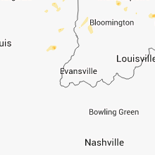
| 9:24 PM EDT | Quarter sized hail reported near Greenwood, IN, 9.7 miles SSE of Indianapolis, IN, hail nickel to quarter size one mile west of greenwood airport. |
| 9:29 PM EDT | Quarter sized hail reported near Greenwood, IN, 10.4 miles SSE of Indianapolis, IN, reported via media facebook page. |
| 9:33 PM EDT | Quarter sized hail reported near Greenwood, IN, 10.4 miles SSE of Indianapolis, IN, quarter size hail at greenwood mall. reported via media facebook page. |
| 9:34 PM EDT | Trees down on houses. power out. time estimated from rada in bartholomew county IN, 38.1 miles SSE of Indianapolis, IN |
| 10:10 PM EDT | Two outbuildings destroyed and a few trees down in ripley county IN, 33.1 miles WNW of Cincinnati, OH |
Connect with Interactive Hail Maps