

Hail Map for Wednesday, August 8, 2018

Number of Impacted Households on 8/8/2018
0
Impacted by 1" or Larger Hail
0
Impacted by 1.75" or Larger Hail
0
Impacted by 2.5" or Larger Hail
Square Miles of Populated Area Impacted on 8/8/2018
0
Impacted by 1" or Larger Hail
0
Impacted by 1.75" or Larger Hail
0
Impacted by 2.5" or Larger Hail


Cities Most Affected by Hail Storms of 8/8/2018
| Hail Size | Demographics of Zip Codes Affected | ||||||
|---|---|---|---|---|---|---|---|
| City | Count | Average | Largest | Pop Density | House Value | Income | Age |
| Bushnell, NE | 1 | 2.50 | 2.50 | 0 | $20k | $28.1k | 53.3 |
| Two Harbors, MN | 1 | 1.75 | 1.75 | 20 | $76k | $42.9k | 45.8 |
Hail and Wind Damage Spotted on 8/8/2018
Filter by Report Type:Hail ReportsWind Reports
States Impacted
Nebraska, Colorado, South Carolina, New York, Tennessee, Kentucky, Virginia, North Carolina, Georgia, Indiana, Florida, New Mexico, Ohio, Massachusetts, Arkansas, Missouri, Alabama, Connecticut, Minnesota, Wisconsin, Pennsylvania, Maryland, Arizona, TexasNebraska
| Local Time | Report Details |
|---|---|
| 6:00 AM MDT | Tennis Ball sized hail reported near Bushnell, NE, 49.4 miles S of Scottsbluff, NE, golf ball to tennis ball hail. |
Colorado
| Local Time | Report Details |
|---|---|
| 6:33 AM MDT | Half Dollar sized hail reported near Grover, CO, 72 miles SSW of Scottsbluff, NE |
| 10:15 AM MDT | Half Dollar sized hail reported near Calhan, CO, 56.6 miles NNE of Pueblo, CO |
South Carolina
| Local Time | Report Details |
|---|---|
| 8:37 AM EDT | Reported a tree in the roadway at the intersection of halfacre road and st. philips church roa in newberry county SC, 62.2 miles NNE of Augusta, GA |
| 2:28 PM EDT | Schp reported a tree down at highway 28 and west union rd in oconee county SC, 25.6 miles WSW of Greenville, SC |
| 2:50 PM EDT | 911 call center reported a tree down in central in pickens county SC, 12.8 miles SW of Greenville, SC |
| 3:40 PM EDT | Media reported trees down on pink dill mill road in greenville county SC, 24.5 miles NE of Greenville, SC |
| 3:43 PM EDT | Schp reported a tree down at jordan rd and highway 14 in greenville county SC, 25 miles NE of Greenville, SC |
| 4:15 PM EDT | Media reported trees down on pink dill mill road in greenville county SC, 24.5 miles NE of Greenville, SC |
| 4:40 PM EDT | Media reported trees down on pink dill mill road in greenville county SC, 24.5 miles NE of Greenville, SC |
| 6:00 PM EDT | Amateur radio reported trees down along harris and hardin street in chester county SC, 41.5 miles SSW of Charlotte, NC |
| 7:45 PM EDT | Schp reported a tree down at eichelberger rd and highway 76 in laurens county SC, 33.9 miles SE of Greenville, SC |
| 7:53 PM EDT | Public reported tree down along indian mound rd in laurens county SC, 39.8 miles SE of Greenville, SC |
| 7:57 PM EDT | Half Dollar sized hail reported near Gray Court, SC, 34.2 miles ESE of Greenville, SC, public reported half dollar (1.25 in) size hail near barksdale |
| 7:58 PM EDT | Schp reported a tree down at 3157 georgia rd in laurens county SC, 31.9 miles ESE of Greenville, SC |
| 7:59 PM EDT | Schp reported a tree down at highway 92 and postell hughes dr in laurens county SC, 32.3 miles ESE of Greenville, SC |
| 8:00 PM EDT | Schp reported a tree down at s harper st ext burnt mill creek rd and lisbon rd in laurens county SC, 44.9 miles SE of Greenville, SC |
| 8:36 PM EDT | Highway patrol reported sunset avenue near mayes avenue blocked due to trees dow in newberry county SC, 61 miles NNE of Augusta, GA |
New York
| Local Time | Report Details |
|---|---|
| 9:15 AM EDT | Several large tree limbs down... minor property damag in erie county NY, 11.7 miles SSE of Buffalo, NY |
| 11:50 AM EDT | County sheriffs office reported trees down in farmington. time estimated based on rada in ontario county NY, 59.5 miles W of Syracuse, NY |
Tennessee
| Local Time | Report Details |
|---|---|
| 10:08 AM CDT | Report of trees down and power outages across the northwestern portions of davidson count in davidson county TN, 10.2 miles NW of Nashville, TN |
| 10:08 AM CDT | Tree fell onto a house in northwestern nashville. no injuries reporte in davidson county TN, 4.5 miles NW of Nashville, TN |
| 10:15 AM CDT | Report of trees and power lines down in the area. power outages as wel in robertson county TN, 16 miles N of Nashville, TN |
| 10:18 AM CDT | Received a report of lots of trees and powerlines down across the southern part of robertson county...including coopertown...ridgetop...white house...and greenbrier. es in robertson county TN, 17.4 miles N of Nashville, TN |
| 10:55 AM CDT | Scattered trees reported down in lebano in wilson county TN, 25.9 miles E of Nashville, TN |
| 11:04 AM CDT | Report of trees down in the belinda city area. tin roof to a shed was also blown off in mundy par in wilson county TN, 16.7 miles E of Nashville, TN |
| 11:16 AM CDT | Facebook report of trees down in the morris subdivision with a soccer goal flung 20 yards into the cumberland river in smith county TN, 44.6 miles E of Nashville, TN |
| 11:20 AM CDT | Wind knocked the steeple off of first baptist church in carthag in smith county TN, 47.3 miles E of Nashville, TN |
| 11:20 AM CDT | Wind knocked the steeple off of first baptist church in carthag in smith county TN, 42.1 miles E of Nashville, TN |
| 11:42 AM CDT | Report of multiple trees and power lines down in gainesboro and in the eastern part of the count in jackson county TN, 64.4 miles ENE of Nashville, TN |
| 2:20 PM EDT | Multiple trees and power lines dow in meigs county TN, 44.4 miles NE of Chattanooga, TN |
| 2:25 PM EDT | Couple of trees dow in scott county TN, 49.8 miles NW of Knoxville, TN |
| 2:55 PM EDT | Large tree dow in blount county TN, 14.5 miles WSW of Knoxville, TN |
| 3:05 PM EDT | Several trees dow in johnson county TN, 24.4 miles ESE of Bristol, TN |
| 3:20 PM EDT | Few trees dow in jefferson county TN, 28.4 miles E of Knoxville, TN |
| 3:35 PM EDT | Power lines and trees dow in monroe county TN, 45.3 miles SSW of Knoxville, TN |
Kentucky
| Local Time | Report Details |
|---|---|
| 11:20 AM CDT | Tree down at the 7000 block of austin tracy roa in barren county KY, 62.7 miles NE of Nashville, TN |
| 12:30 PM CDT | Tree down on fairgrounds road in albany. also trees down on lynnview drive... and on state highways 1076 and 558 out in the count in clinton county KY, 84.6 miles NW of Knoxville, TN |
| 2:02 PM EDT | Power line down on tree which resulted in tree catching on fire. time estimated from rada in wayne county KY, 77 miles SW of Irvine, KY |
| 2:36 PM EDT | Tree down on antioch roa in pulaski county KY, 59.9 miles SW of Irvine, KY |
| 2:36 PM EDT | Tree down on cedar grove roa in pulaski county KY, 56.7 miles SW of Irvine, KY |
| 2:58 PM EDT | Tree down on corinth r in whitley county KY, 56 miles S of Irvine, KY |
Virginia
| Local Time | Report Details |
|---|---|
| 12:40 PM EDT | 20 trees and power lines down in pittsylvania county VA, 47.2 miles ESE of Roanoke, VA |
| 1:51 PM EDT | One tree blown down that took down a power line near the intersection of georges run road and mount pleasant road in montgomery county VA, 22.3 miles WSW of Roanoke, VA |
| 1:59 PM EDT | One tree blown down along the 7600 block of roanoke road in montgomery county VA, 17.9 miles WSW of Roanoke, VA |
| 2:16 PM EDT | Large tree down on spring valley road blocking traffic. time estimated from rada in smyth county VA, 40.3 miles ENE of Bristol, TN |
| 2:16 PM EDT | Large tree down on spring valley road blocking traffic. time estimated from rada in smyth county VA, 41 miles ENE of Bristol, TN |
| 2:35 PM EDT | Two trees and a powerline downed on east lee highway. time estimated from rada in wythe county VA, 62.3 miles WSW of Roanoke, VA |
| 3:12 PM EDT | One tree blown down on the 5800 block of riner road that is blocking both lanes in montgomery county VA, 31.7 miles WSW of Roanoke, VA |
| 3:20 PM EDT | One tree blown down near the intersection of laurel branch road and weddle creek road in floyd county VA, 34.4 miles SW of Roanoke, VA |
| 3:22 PM EDT | Tree down on house in city of danville county VA, 55.4 miles SSE of Roanoke, VA |
| 3:30 PM EDT | One tree blown down near the intersection of huffville road and lick ridge road in floyd county VA, 23.3 miles SW of Roanoke, VA |
| 3:31 PM EDT | Trees down in city of danville county VA, 56.9 miles SE of Roanoke, VA |
| 3:42 PM EDT | Power line down on lick ridge road near chec in floyd county VA, 22 miles SW of Roanoke, VA |
| 5:37 PM EDT | Trees and power lines down on 7100 block of trimble roa in rockingham county VA, 68.5 miles SE of Elkins, WV |
| 5:42 PM EDT | Power lines down on 6800 block of new haven roa in rockingham county VA, 70.6 miles SE of Elkins, WV |
| 5:42 PM EDT | Tree down on 100 block of eakle roa in augusta county VA, 72 miles SE of Elkins, WV |
| 5:55 PM EDT | Tree down on 700 block of hildebrand church roa in augusta county VA, 75.2 miles SE of Elkins, WV |
| 6:21 PM EDT | Tree down near intersection of garth road and millington roa in albemarle county VA, 67.9 miles NW of Richmond, VA |
| 7:27 PM EDT | Trees down on tye brook highway near us 29 in nelson county VA, 62.7 miles ENE of Roanoke, VA |
| 7:55 PM EDT | Several trees/branches reported down along hadensville r in goochland county VA, 27.3 miles NW of Richmond, VA |
North Carolina
| Local Time | Report Details |
|---|---|
| 12:40 PM EDT | 20 trees and power lines down in surry county NC, 64.8 miles SW of Roanoke, VA |
| 1:46 PM EDT | Tree down on steele road near sandy ridge. time estimated from rada in stokes county NC, 55.7 miles SSW of Roanoke, VA |
| 1:48 PM EDT | Tree down on tom shelton road near sandy ridge. time estimated from rada in stokes county NC, 57 miles S of Roanoke, VA |
| 2:16 PM EDT | Downed powerline on barney venable road. time esimtate in surry county NC, 68.5 miles SSW of Roanoke, VA |
| 2:55 PM EDT | Tree down on camp dan valley road blocking one lane. time estimated from rada in rockingham county NC, 62 miles SSE of Roanoke, VA |
| 3:38 PM EDT | A tree and a power line down on lee street. time estimated from rada in caswell county NC, 57.2 miles NW of Raleigh, NC |
| 3:48 PM EDT | Large tree limb down in caswell county NC, 60.6 miles NNW of Raleigh, NC |
| 4:20 PM EDT | Trained spotter reported trees down on rome jones road in catawba county NC, 35.4 miles NW of Charlotte, NC |
| 4:20 PM EDT | Trained spotter reported trees down on hardwood circle in catawba county NC, 38.6 miles NW of Charlotte, NC |
| 4:31 PM EDT | Emergency mngr reported on trees down along hwy 226 in mcdowell county NC, 67 miles SSE of Bristol, TN |
| 4:35 PM EDT | Multiple trees dow in cherokee county NC, 57.4 miles S of Knoxville, TN |
| 4:39 PM EDT | Tree down on carroll store rd and holland r in sampson county NC, 50.1 miles S of Raleigh, NC |
| 4:41 PM EDT | Trees were reported down on power lines on maxwell roa in sampson county NC, 46.7 miles S of Raleigh, NC |
| 4:45 PM EDT | Trained spotter reported trees down along jenkins r in burke county NC, 59.3 miles WNW of Charlotte, NC |
| 4:55 PM EDT | Tree down on n oneal st at billingham dr in burlingto in alamance county NC, 50.4 miles WNW of Raleigh, NC |
| 5:05 PM EDT | 911 call center reported numerous trees and lines dow in cleveland county NC, 39.4 miles W of Charlotte, NC |
| 5:06 PM EDT | Public reported on large branches down along north fork roa in buncombe county NC, 57.2 miles SSW of Bristol, TN |
| 5:09 PM EDT | A tree and power line down at 300 tinnin r in orange county NC, 36.8 miles NW of Raleigh, NC |
| 5:09 PM EDT | Power line down on driveway on rogers r in alamance county NC, 45.5 miles WNW of Raleigh, NC |
| 5:10 PM EDT | Quarter sized hail reported near Hildebran, NC, 47 miles NW of Charlotte, NC, public reported quarter (1.00 in) size hail on 3rd st se |
| 5:14 PM EDT | One power line blown down along the 2900 block of route 8 in stokes county NC, 59 miles SSW of Roanoke, VA |
| 5:14 PM EDT | Tree down at old hillsborough rd and longleaf pine p in alamance county NC, 40.4 miles WNW of Raleigh, NC |
| 5:16 PM EDT | Public reported on tree down on building on 13th ave place nw in catawba county NC, 46.1 miles NW of Charlotte, NC |
| 5:21 PM EDT | One tree blown down at the intersection of seven island road and damascus road in stokes county NC, 59.1 miles SSW of Roanoke, VA |
| 5:21 PM EDT | One tree blown down near the intersection of moxley road and north oak ridge church road in yadkin county NC, 68.3 miles N of Charlotte, NC |
| 5:25 PM EDT | One tree blown down along the 3200 block of moir farm road in stokes county NC, 57.1 miles SSW of Roanoke, VA |
| 5:30 PM EDT | Law enforcement reported trees and powerlines down along sellerstown rd in gaston county NC, 31 miles WNW of Charlotte, NC |
| 5:36 PM EDT | Public reported large hickory tree down along mauney r in gaston county NC, 27 miles WNW of Charlotte, NC |
| 5:40 PM EDT | Over 20 trees down and a couple of power lines... one with a tree down on the power line in the shoals area not far from pilot mountain and interstate 74/u.s. highway 5 in surry county NC, 72.1 miles SSW of Roanoke, VA |
| 5:45 PM EDT | Tree and power line down on chapel hill rd and vesson ave in durha in durham county NC, 21 miles NW of Raleigh, NC |
| 5:47 PM EDT | Trained spotter reported trees down near iron station in lincoln county NC, 23.6 miles NW of Charlotte, NC |
| 5:47 PM EDT | Amateur radio reported downed trees blocking hwy 27 in lincoln county NC, 24 miles NW of Charlotte, NC |
| 5:48 PM EDT | Tree down at 1324 west greensboro chapel hill r in alamance county NC, 46.6 miles W of Raleigh, NC |
| 5:50 PM EDT | One tree blown down that also took down a power line near the intersection of ayersville road and turner road in rockingham county NC, 59.5 miles S of Roanoke, VA |
| 5:53 PM EDT | Power line down at 3151 westinghouse r in forsyth county NC, 74.8 miles SSW of Roanoke, VA |
| 5:53 PM EDT | Public reported trees down along mount zion church road in lincoln county NC, 19.7 miles NW of Charlotte, NC |
| 5:53 PM EDT | One tree blown down at the intersection of highway 772 and bethesda church road in stokes county NC, 62.6 miles S of Roanoke, VA |
| 5:55 PM EDT | Ping Pong Ball sized hail reported near Mooresville, NC, 21.9 miles N of Charlotte, NC, social media reported ping pong ball (1.50 in) size hail along faith rd. |
| 5:55 PM EDT | Power line down at 1200 shore r in forsyth county NC, 74.5 miles NNE of Charlotte, NC |
| 5:59 PM EDT | Tree down on willard rd. time estimated by rada in randolph county NC, 53.3 miles W of Raleigh, NC |
| 6:00 PM EDT | Corrects previous tstm wnd dmg report from 2 s snow camp. multiple trees were reported down on a home and vehicles along griffin rd near carl johnson road. 10-15 trees in chatham county NC, 43.3 miles W of Raleigh, NC |
| 6:05 PM EDT | Trained spotter reported tree down along faith r in iredell county NC, 21.9 miles N of Charlotte, NC |
| 6:08 PM EDT | Tree down blocking southbound lane of highway 421... at exit for highway 4 in randolph county NC, 52.1 miles W of Raleigh, NC |
| 6:08 PM EDT | Tree down at sandy creek church rd. and hicks country l in randolph county NC, 53.3 miles W of Raleigh, NC |
| 6:09 PM EDT | Tree down at old liberty rd and benny lineberry r in randolph county NC, 58.4 miles W of Raleigh, NC |
| 6:15 PM EDT | Large tree down on arbor and kent road... a few blocks from the wxii 12 news station and arbor acres retirement community in winston-sale in forsyth county NC, 69.6 miles NNE of Charlotte, NC |
| 6:15 PM EDT | Tree down on andrew hunter r in randolph county NC, 60.1 miles W of Raleigh, NC |
| 6:18 PM EDT | Tree down on residential structure on staley snow camp r in chatham county NC, 48.3 miles W of Raleigh, NC |
| 6:32 PM EDT | Trees were reported down on power lines near the intersection of holly springs road and sunset lake roa in wake county NC, 11.9 miles SW of Raleigh, NC |
| 6:35 PM EDT | Scanner reports of fds dispatched to numerous trees and powerlines downed countywide in cabarrus county NC, 19.5 miles NE of Charlotte, NC |
| 6:35 PM EDT | Trained spotter reported trees down near enochville in rowan county NC, 22.6 miles NNE of Charlotte, NC |
| 6:40 PM EDT | Tree down on nc highway 8 and lookabill r in davidson county NC, 45.6 miles ENE of Charlotte, NC |
| 6:43 PM EDT | Corrects previous tstm wnd dmg report from 7 wnw bynum. tree down blocking roadway on nc highway 87 n and chicken bridge r in chatham county NC, 34.2 miles W of Raleigh, NC |
| 6:50 PM EDT | Tree down blocking roadway on nc highway 87 n and chicken bridge r in chatham county NC, 34.2 miles W of Raleigh, NC |
| 7:00 PM EDT | Numerous trees reported down throughout stanly count in stanly county NC, 34.7 miles ENE of Charlotte, NC |
| 7:00 PM EDT | Multiple trees were reported down on a home and vehicles along griffin rd near carl johnson road. 10-15 trees were reported down on property. a detached garage was stru in chatham county NC, 43.3 miles W of Raleigh, NC |
| 7:09 PM EDT | Tree down at bringle ferry rd and nc highway in davidson county NC, 46.1 miles NE of Charlotte, NC |
| 7:14 PM EDT | Tree down at alleghany church rd and nc highway in davidson county NC, 44.9 miles ENE of Charlotte, NC |
| 7:19 PM EDT | Tree down at burney mill rd and lassiter mill r in randolph county NC, 53.1 miles ENE of Charlotte, NC |
| 7:32 PM EDT | Tree down at new hope church rd and bethel lucas r in randolph county NC, 60.7 miles ENE of Charlotte, NC |
| 7:42 PM EDT | Tree down blocking traffic on erect rd near fork creek mill r in randolph county NC, 59.3 miles WSW of Raleigh, NC |
| 7:45 PM EDT | Multiple reports of trees down in the silk hope... siler city... and bennett area in chatham county NC, 53.2 miles WSW of Raleigh, NC |
| 7:47 PM EDT | 13 homes with trees on them... 3 significantly damaged. a home also had windows blown ou in johnston county NC, 25.7 miles SSE of Raleigh, NC |
| 8:12 PM EDT | Numerous trees and power lines down throughout moore count in moore county NC, 53.5 miles SW of Raleigh, NC |
| 8:16 PM EDT | Trees were reported down on power lines in downtown rockingha in richmond county NC, 63.5 miles ESE of Charlotte, NC |
| 8:30 PM EDT | Two trees were reported down in pikevill in wayne county NC, 42.2 miles ESE of Raleigh, NC |
| 8:51 PM EDT | Tree down on stoney point rd and galatia church r in cumberland county NC, 58.4 miles SSW of Raleigh, NC |
| 8:54 PM EDT | Tree down on sequoia rd and elder ln. time estimated from rada in cumberland county NC, 54.6 miles SSW of Raleigh, NC |
| 9:18 PM EDT | One tree was reported down on nc highway 50 near reedy prong church roa in johnston county NC, 35.7 miles SSE of Raleigh, NC |
Georgia
| Local Time | Report Details |
|---|---|
| 1:47 PM EDT | 911 call center reported trees down along georgia hwy 15 in rabun county GA, 45.3 miles W of Greenville, SC |
| 3:15 PM EDT | Tree fell south of chickamuga causing minor damage to a residenc in walker county GA, 17.1 miles S of Chattanooga, TN |
| 3:30 PM EDT | Reports of at least a couple trees down in southern lafayette including one large tree knocking down powerlines at s chattanooga and bronco rd as well as some minor tre in walker county GA, 24.6 miles S of Chattanooga, TN |
| 3:30 PM EDT | Large tree down over powerlines on s chattanooga st in lafayett in walker county GA, 24.6 miles S of Chattanooga, TN |
| 4:00 PM EDT | Reports of trees down accross powerlines and roads on back penn rd and saddle club rd north of summerville in chattooga county GA, 36.3 miles S of Chattanooga, TN |
| 4:05 PM EDT | Tree down across powerlines on mustang dr... east of summerville in chattooga county GA, 37.9 miles S of Chattanooga, TN |
| 4:15 PM EDT | Report of a tree down near the intersection of macedonia church rd and madola rd in fannin county GA, 49.9 miles E of Chattanooga, TN |
| 4:15 PM EDT | Report of a tree down near the intersection of macedonia church rd and madola rd in fannin county GA, 49.9 miles E of Chattanooga, TN |
| 4:20 PM EDT | Confirmed reports of a tree down on a house on the se side of epworth in fannin county GA, 53.2 miles E of Chattanooga, TN |
| 4:26 PM EDT | One to two trees downed by thunderstorm winds near the intersection of dillon rd and clyde griffin rd just north of thomasville airpor in thomas county GA, 41.3 miles NE of Tallahassee, FL |
| 4:38 PM EDT | Tree down on powerlines on haymore farm rd outside of mineral bluf in fannin county GA, 60.4 miles E of Chattanooga, TN |
| 5:04 PM EDT | Power line down reported at 401 francis drive... lake park... lowndes... g in lowndes county GA, 60.8 miles SSW of Douglas, GA |
| 5:07 PM EDT | Tree or power line down on touchton roa in lowndes county GA, 57.7 miles SSW of Douglas, GA |
| 5:07 PM EDT | Tree or power line down on madison highwa in lowndes county GA, 58.6 miles SSW of Douglas, GA |
| 5:37 PM EDT | Tree or power line down on on lori stree in lowndes county GA, 44.7 miles SSW of Douglas, GA |
| 6:20 PM EDT | Trees down near willacoochee. time given was based on rada in atkinson county GA, 15.1 miles SW of Douglas, GA |
| 6:43 PM EDT | Tree down on powerline in cherokee county GA, 33.9 miles N of Atlanta, GA |
| 6:45 PM EDT | Trees down southwest of douglas. time given was based on rada in coffee county GA, 8.4 miles WSW of Douglas, GA |
| 7:00 PM EDT | Tree and powerline down along dixie union road. time given was based on rada in ware county GA, 27.8 miles ESE of Douglas, GA |
| 8:09 PM EDT | Quarter sized hail reported near Macon, GA, 71.2 miles SE of Atlanta, GA |
| 9:30 PM EDT | Columbia co dispatch confirmed media report of a fallen tree that grazed the front of a home... blocking the front door... on crown point dr. no injurie in columbia county GA, 6 miles NW of Augusta, GA |
Indiana
| Local Time | Report Details |
|---|---|
| 2:15 PM EDT | Large tree downed... approximately 3 to 3.5 feet in diamete in whitley county IN, 21.5 miles NW of Fort Wayne, IN |
| 5:25 PM EDT | Spotter report of numerous healthy trees and limbs up to 6 inches diameter down on sr 105 between 250 s and the salamonie reservoir in huntington county. all damage see in huntington county IN, 34 miles SW of Fort Wayne, IN |
Florida
| Local Time | Report Details |
|---|---|
| 3:35 PM EDT | 911 call center reported tree and powerline down on 76th street. time is estimated based on radar imager in suwannee county FL, 69.9 miles E of Tallahassee, FL |
| 3:40 PM EDT | 911 call center reported tree and powerline down on 16th street. time is estimated based on radar imager in suwannee county FL, 69.9 miles E of Tallahassee, FL |
| 3:55 PM EDT | 911 call center reported trees and powerlines down along county road 136 and 137 in the northeast portion of the county. time estimated based on radar imager in suwannee county FL, 69.6 miles W of Jacksonville, FL |
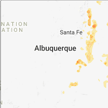
New Mexico
| Local Time | Report Details |
|---|---|
| 2:10 PM MDT | Ping Pong Ball sized hail reported near Ocate, NM, 32.8 miles ESE of Taos, NM, spotter reported ping-pong sized hail and very heavy rainfall. |
| 7:32 PM MDT | Storm damage reported in de baca county NM, 54.3 miles SW of Tucumcari, NM |
Ohio
| Local Time | Report Details |
|---|---|
| 4:15 PM EDT | Branches ranging from 6-12 inches broken off trees-near intersection of sr 18 and vine stree in henry county OH, 62.7 miles E of Fort Wayne, IN |
| 4:15 PM EDT | Branches ranging from 6-12 inches broken off trees-near intersection of sr 18 and vine stree in henry county OH, 62.7 miles E of Fort Wayne, IN |
| 4:15 PM EDT | Large tree limb... approximately 1 ft in diameter snapped off. limb is partially rotted. near intersection of sr 18 and oak stree in henry county OH, 63.8 miles E of Fort Wayne, IN |
Massachusetts
| Local Time | Report Details |
|---|---|
| 4:21 PM EDT | Power lines down at egremont plain road and boice road in berkshire county MA, 49.4 miles SSE of Schenectady, NY |
Arkansas
| Local Time | Report Details |
|---|---|
| 4:32 PM CDT | Social media reports of a couple of trees down across hot spring county... west of malver in hot spring county AR, 42.8 miles SW of Little Rock, AR |
| 4:41 PM CDT | Trees were blown down on highway 9 and highway 30 in dallas county AR, 50.8 miles SSW of Little Rock, AR |
| 4:50 PM CDT | A tree was blown dow in dallas county AR, 65.9 miles E of Nashville, AR |
| 4:50 PM CDT | Trees and power lines were blown down on highway 22 in dallas county AR, 47.7 miles SSW of Little Rock, AR |
| 4:50 PM CDT | Trees and power lines were blown down on highway 22 in dallas county AR, 47.7 miles SSW of Little Rock, AR |
| 4:55 PM CDT | Trees were blown down along highway 16 in dallas county AR, 48.1 miles SSW of Little Rock, AR |
| 5:22 PM CDT | Cleveland county sheriff's office reported trees and powerlines were blown down by thunderstorm winds at multiple locations across the count in cleveland county AR, 55.3 miles S of Little Rock, AR |
Missouri
| Local Time | Report Details |
|---|---|
| 4:35 PM CDT | Barn destroyed. time/location approximate pending further inf in oregon county MO, 63.6 miles S of Salem, MO |
| 5:02 PM CDT | Two trees were reported down on county road 10 in douglas county MO, 43.8 miles ESE of Springfield, MO |
| 5:04 PM CDT | Report of tree down just south of lamp in stone county MO, 46.1 miles S of Springfield, MO |
| 5:12 PM CDT | Downed tree at indian point. timing estimated from rada in stone county MO, 38 miles S of Springfield, MO |
Alabama
| Local Time | Report Details |
|---|---|
| 4:59 PM CDT | Large tree limbs down. time and location estimated from rada in marshall county AL, 68.4 miles SW of Chattanooga, TN |
| 6:03 PM CDT | Several trees reported down in the double bridges community. time estimated from rada in marshall county AL, 63.4 miles NE of Birmingham, AL |
| 6:38 PM CDT | A large tree was blown down along i-759 in gadsden. winds measured at 51 mph in gadsde in etowah county AL, 55.4 miles NE of Birmingham, AL |
| 6:38 PM CDT | A large tree fell on a vehicle along highway 411 and country club dr. one person trapped in vehicle. winds measured at 51 mp in etowah county AL, 55.1 miles NE of Birmingham, AL |
Connecticut
| Local Time | Report Details |
|---|---|
| 6:09 PM EDT | Tree down on wires on swamp rd in newtown ct in fairfield county CT, 59.8 miles NE of Brooklyn, NY |
| 6:23 PM EDT | Tree down on walnut tree rd in newtown ct in fairfield county CT, 63.8 miles NE of Brooklyn, NY |
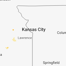
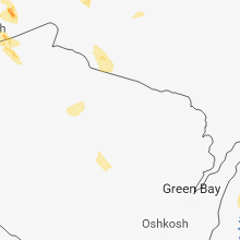
Minnesota
| Local Time | Report Details |
|---|---|
| 5:20 PM CDT | Quarter sized hail reported near Two Harbors, MN, 33.6 miles NE of Duluth, MN, largest hail stones were quarter sized. |
| 5:28 PM CDT | Half Dollar sized hail reported near Two Harbors, MN, 30.1 miles NE of Duluth, MN, hail covering the road on county road 2 approximately 6 miles north of two harbors. largest hail stones were half dollar sized. time estimated by radar. |
| 5:37 PM CDT | Golf Ball sized hail reported near Two Harbors, MN, 27.9 miles NE of Duluth, MN, largest hail stones were golf ball sized. minor damage to a few vehicles. time estimated by radar. |
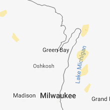
Wisconsin
| Local Time | Report Details |
|---|---|
| 6:38 PM CDT | Tree knocked down along highway 13 in port wing wisconsin. time estimated from rada in bayfield county WI, 34.2 miles E of Duluth, MN |
| 7:38 PM CDT | Tree knocked down near the intersection of county road a and ferguson road. tree blocking ferguson road. time estimated by rada in douglas county WI, 32.3 miles SSE of Duluth, MN |
Pennsylvania
| Local Time | Report Details |
|---|---|
| 8:02 PM EDT | Multiple trees down in quincy townshi in franklin county PA, 59.6 miles NW of Baltimore, MD |
Maryland
| Local Time | Report Details |
|---|---|
| 8:22 PM EDT | Tree down on 10400 block of catholic church roa in washington county MD, 76.6 miles S of State College, PA |
| 8:31 PM EDT | Tree down on broadfoarding roa in washington county MD, 74.5 miles WNW of Baltimore, MD |
| 8:50 PM EDT | Tree down on 10800 block of bower avenu in washington county MD, 65.9 miles WNW of Baltimore, MD |
| 8:53 PM EDT | Downed power lines on 1000 block of georgia avenu in washington county MD, 65.1 miles WNW of Baltimore, MD |
| 9:49 PM EDT | Tree down in the 2400 block of sams creek road in carroll county MD, 28.1 miles WNW of Baltimore, MD |
| 10:00 PM EDT | Tree down in the 4600 block of london bridge road in carroll county MD, 21.7 miles WNW of Baltimore, MD |
| 10:01 PM EDT | Tree down on deer park road in carroll county MD, 21.6 miles NW of Baltimore, MD |
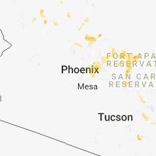
Arizona
| Local Time | Report Details |
|---|---|
| 7:23 PM MST | Storm damage reported in maricopa county AZ, 27.4 miles ENE of Phoenix, AZ |
| 7:25 PM MST | Numerous power lines downed trapping people in 7 cars. time estimated based on rada in maricopa county AZ, 18.1 miles NNE of Phoenix, AZ |
| 7:27 PM MST | Power poles and numerous trees dow in maricopa county AZ, 9.8 miles ENE of Phoenix, AZ |
| 7:30 PM MST | Large tree downed. time estimated by rada in maricopa county AZ, 22.9 miles E of Phoenix, AZ |
| 7:31 PM MST | Asos station sdl... scottsdale municipal airpor in maricopa county AZ, 15.2 miles NE of Phoenix, AZ |
| 7:40 PM MST | Storm damage reported in maricopa county AZ, 19.5 miles E of Phoenix, AZ |
| 7:51 PM MST | Corrected time of occurence. asos station phx... phoenix sky harbor intl arp in maricopa county AZ, 4.6 miles ESE of Phoenix, AZ |
| 7:55 PM MST | Large branch on light rail... apache blvd. near/e. of mcclintoc in maricopa county AZ, 9.9 miles ESE of Phoenix, AZ |
| 7:58 PM MST | Reported at 1924 e. wesleyan dr.... tempe... flagpole snapped in hal in maricopa county AZ, 10.7 miles ESE of Phoenix, AZ |
| 8:00 PM MST | Asos station phx... phoenix sky harbor intl arp in maricopa county AZ, 4.6 miles ESE of Phoenix, AZ |
| 8:01 PM MST | Trees and large tree debris on hwy 101 near hwy 60 and guadeloupe rd. on-ramp. driving hazard in maricopa county AZ, 12 miles ESE of Phoenix, AZ |
| 8:05 PM MST | Power outage mcclintock dr. and apache blv in maricopa county AZ, 9.9 miles ESE of Phoenix, AZ |
| 8:15 PM MST | Storm damage reported in maricopa county AZ, 35.5 miles W of Phoenix, AZ |
| 8:16 PM MST | Broken limbs and shingles... vsby < 0.2 mi.... power outag in maricopa county AZ, 12.5 miles E of Phoenix, AZ |
| 8:18 PM MST | Reported at dobson and southern... mesa... az 3 ft. diameter tree uproote in maricopa county AZ, 12.6 miles ESE of Phoenix, AZ |
| 8:19 PM MST | Augments previous tstm wnd dmg report from 2 nnw sky harbor airport to add hwy name. tree on red mountain 202 hwy. near i-10 driving hazar in maricopa county AZ, 2.8 miles ENE of Phoenix, AZ |
Texas
| Local Time | Report Details |
|---|---|
| 9:35 PM CDT | Storm damage reported in dawson county TX, 58.2 miles S of Lubbock, TX |
Connect with Interactive Hail Maps