

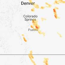
Hail Map for Tuesday, August 7, 2018

Number of Impacted Households on 8/7/2018
0
Impacted by 1" or Larger Hail
0
Impacted by 1.75" or Larger Hail
0
Impacted by 2.5" or Larger Hail
Square Miles of Populated Area Impacted on 8/7/2018
0
Impacted by 1" or Larger Hail
0
Impacted by 1.75" or Larger Hail
0
Impacted by 2.5" or Larger Hail


Cities Most Affected by Hail Storms of 8/7/2018
| Hail Size | Demographics of Zip Codes Affected | ||||||
|---|---|---|---|---|---|---|---|
| City | Count | Average | Largest | Pop Density | House Value | Income | Age |
| Flagler, CO | 2 | 2.00 | 2.00 | 1 | $74k | $30.4k | 46.7 |
| Meriden, WY | 1 | 2.50 | 2.50 | 1 | $113k | $29.0k | 46.0 |
| Weston, CO | 1 | 2.00 | 2.00 | 2 | $83k | $26.3k | 54.8 |
| Parker, CO | 1 | 1.75 | 1.75 | 472 | $232k | $78.4k | 38.4 |
| Fountain, CO | 1 | 1.75 | 1.75 | 421 | $118k | $42.2k | 29.0 |
| Maxwell, NM | 1 | 1.75 | 1.75 | 1 | $63k | $27.9k | 43.4 |
| Aurora, CO | 1 | 1.75 | 1.75 | 997 | $406k | $114.5k | 36.8 |
| Peyton, CO | 1 | 1.75 | 1.75 | 127 | $173k | $54.4k | 36.2 |
Hail and Wind Damage Spotted on 8/7/2018
Filter by Report Type:Hail ReportsWind Reports
States Impacted
Maine, Missouri, Colorado, Georgia, Pennsylvania, New York, Vermont, Indiana, District of Columbia, Maryland, Virginia, North Carolina, Oklahoma, Alabama, Louisiana, Massachusetts, Ohio, New Hampshire, Arkansas, Kentucky, South Carolina, Iowa, Wyoming, New Jersey, Mississippi, Nebraska, New MexicoMaine
| Local Time | Report Details |
|---|---|
| 8:24 AM EDT | Corrects previous tstm wnd dmg report from rista rd. trees down. power pole to house dow in aroostook county ME, 10 miles NNW of Caribou, ME |
| 1:33 PM EDT | Corrects previous tstm wnd dmg report from sangerville. trees down knowlton mills rd and on main s in piscataquis county ME, 38 miles NW of Bangor, ME |
| 1:39 PM EDT | Corrects previous tstm wnd dmg report from dover-foxcroft. trees down on essex s in piscataquis county ME, 35 miles NW of Bangor, ME |
| 1:40 PM EDT | Corrects previous tstm wnd dmg report from gilford. trees down on sebec shores r in penobscot county ME, 39.6 miles N of Bangor, ME |
| 2:15 PM EDT | Spotter reports a few trees down on school house rd in orien in aroostook county ME, 72.9 miles S of Caribou, ME |
| 2:24 PM EDT | Trees down. power pole to house dow in aroostook county ME, 10 miles NNW of Caribou, ME |
| 2:33 PM EDT | Trees down knowlton mills rd and on main s in piscataquis county ME, 38 miles NW of Bangor, ME |
| 2:39 PM EDT | Trees down on essex s in piscataquis county ME, 35 miles NW of Bangor, ME |
| 2:40 PM EDT | Trees down on sebec shores r in penobscot county ME, 39.6 miles N of Bangor, ME |
| 5:17 PM EDT | Trees down. time estimated from rada in cumberland county ME, 20.5 miles NNW of Portland, ME |
| 5:20 PM EDT | Tree down on power line in cumberland county ME, 21.6 miles N of Portland, ME |
| 5:20 PM EDT | Tree down on power lines. time estimated from rada in cumberland county ME, 20.2 miles N of Portland, ME |
| 5:35 PM EDT | Trees down and debris in roadway in androscoggin county ME, 29.3 miles NNE of Portland, ME |
| 7:40 PM EDT | Trees down on airport road... monroe road... and lebanon roa in waldo county ME, 17.5 miles SW of Bangor, ME |
| 7:55 PM EDT | Power lines dow in penobscot county ME, 5.5 miles SW of Bangor, ME |
| 8:00 PM EDT | Power lines down in town. time estimated from rada in penobscot county ME, 5.7 miles SSW of Bangor, ME |
| 8:10 PM EDT | Power lines dow in penobscot county ME, 12.9 miles E of Bangor, ME |
Missouri
| Local Time | Report Details |
|---|---|
| 11:25 AM CDT | Delayed report. several large limbs were reported down. some fence damage occurred from falling limb in webster county MO, 33 miles ESE of Springfield, MO |
| 11:30 AM CDT | Report of a few 1 inch limbs and shingles blown off a gas statio in webster county MO, 29.1 miles E of Springfield, MO |
| 12:25 PM CDT | A few shingles loose and blown off of a rooftop near norwoo in wright county MO, 48.6 miles E of Springfield, MO |
| 12:45 PM CDT | Public report of an estimated 60mph wind gust and rain blowing sideway in texas county MO, 33.6 miles SW of Salem, MO |
| 12:47 PM CDT | Social media post of large branches broken off a tree. time estimated via rada in texas county MO, 31.5 miles SW of Salem, MO |
Colorado
| Local Time | Report Details |
|---|---|
| 10:58 AM MDT | Half Dollar sized hail reported near Peyton, CO, 49.4 miles N of Pueblo, CO |
| 3:05 PM MDT | Quarter sized hail reported near Colorado City, CO, 25.8 miles SSW of Pueblo, CO, a colorado city... city employee... reported the 1.0 inch hail. |
| 3:12 PM MDT | Quarter sized hail reported near Boncarbo, CO, 72.6 miles NE of Taos, NM |
| 3:19 PM MDT | Ping Pong Ball sized hail reported near Divide, CO, 51.7 miles S of Denver, CO |
| 4:05 PM MDT | Quarter sized hail reported near Greeley, CO, 46.5 miles NNE of Denver, CO, mix of dimes... nickles and quarters. |
| 4:06 PM MDT | Quarter sized hail reported near Rye, CO, 26.5 miles SSW of Pueblo, CO |
| 4:06 PM MDT | Golf Ball sized hail reported near Aurora, CO, 18.7 miles SE of Denver, CO, report via twitter. |
| 4:10 PM MDT | Half Dollar sized hail reported near Colorado Springs, CO, 40.4 miles NNW of Pueblo, CO |
| 4:10 PM MDT | Golf Ball sized hail reported near Parker, CO, 19.1 miles SE of Denver, CO |
| 4:12 PM MDT | Hen Egg sized hail reported near Weston, CO, 65.8 miles NE of Taos, NM |
| 5:11 PM MDT | Quarter sized hail reported near Loveland, CO, 45.4 miles NNW of Denver, CO |
| 5:29 PM MDT | Quarter sized hail reported near Berthoud, CO, 41 miles N of Denver, CO |
| 5:46 PM MDT | Ping Pong Ball sized hail reported near Mead, CO, 31.7 miles N of Denver, CO |
| 5:53 PM MDT | Quarter sized hail reported near Longmont, CO, 31.8 miles N of Denver, CO |
| 5:53 PM MDT | Ping Pong Ball sized hail reported near Longmont, CO, 29.1 miles N of Denver, CO |
| 6:00 PM MDT | Quarter sized hail reported near Fort Lupton, CO, 24.7 miles NNE of Denver, CO |
| 6:00 PM MDT | Quarter sized hail reported near Westcliffe, CO, 40.7 miles WSW of Pueblo, CO |
| 6:18 PM MDT | Quarter sized hail reported near Westcliffe, CO, 41.3 miles WSW of Pueblo, CO |
| 6:20 PM MDT | Hen Egg sized hail reported near Flagler, CO, 43.1 miles SSW of Yuma, CO |
| 6:32 PM MDT | Hen Egg sized hail reported near Flagler, CO, 46.8 miles SSW of Yuma, CO, golf ball to hen egg size hail covering the ground to a depth of 6 inches. |
| 7:32 PM MDT | Quarter sized hail reported near Seibert, CO, 62 miles SSW of Yuma, CO |
| 7:59 PM MDT | Half Dollar sized hail reported near Eckley, CO, 12.9 miles E of Yuma, CO |
| 10:50 PM MDT | Ping Pong Ball sized hail reported near Peyton, CO, 44.6 miles N of Pueblo, CO |
| 10:58 PM MDT | Ping Pong Ball sized hail reported near Peyton, CO, 49.4 miles N of Pueblo, CO |
| 10:58 PM MDT | Half Dollar sized hail reported near Peyton, CO, 49.4 miles N of Pueblo, CO, corrects time on previous hail report from 3 n falcon. |
| 11:00 PM MDT | Ping Pong Ball sized hail reported near Peyton, CO, 43.2 miles N of Pueblo, CO |
| 11:02 PM MDT | Golf Ball sized hail reported near Peyton, CO, 46.6 miles N of Pueblo, CO |
| 11:05 PM MDT | Quarter sized hail reported near Peyton, CO, 48 miles N of Pueblo, CO |
| 11:10 PM MDT | Quarter sized hail reported near Peyton, CO, 46 miles N of Pueblo, CO |
| 11:12 PM MDT | Golf Ball sized hail reported near Fountain, CO, 18.4 miles N of Pueblo, CO |
Georgia
| Local Time | Report Details |
|---|---|
| 1:00 PM EDT | Multiple trees blown down on broughton rd near godfrey in morgan county GA, 48.2 miles ESE of Atlanta, GA |
| 1:10 PM EDT | Social media report of a tree down 0.5 miles se of hwy 155 & hwy 138. tree fell on a house causing minor damage to the roo in henry county GA, 17.7 miles SE of Atlanta, GA |
| 2:30 PM EDT | 2 trees down just nnw of monro in walton county GA, 37.9 miles E of Atlanta, GA |
| 2:50 PM EDT | Tree fell in the center of the town of roberta... knocking out a transformer near hwy 80 and 341 in crawford county GA, 73.9 miles SSE of Atlanta, GA |
| 2:55 PM EDT | A tree was downed onto power lines at intersection of hwy 341 and hwy 12 in crawford county GA, 74.2 miles SSE of Atlanta, GA |
| 3:25 PM EDT | Law enforcment reported a tree down on hwy 240 1 mile south of geneva in talbot county GA, 55 miles E of Auburn, AL |
| 4:00 PM EDT | Unverified report of 1" hail on southern side of warner robins in houston county GA, 84.8 miles NNW of Douglas, GA |
| 4:06 PM EDT | Report of a tree down near the intersection of hwy 74 w and lawrence road in molena... g in upson county GA, 53.9 miles S of Atlanta, GA |
| 4:50 PM EDT | 911 reports a tree down on powerlines on companion driv in bibb county GA, 76.8 miles SE of Atlanta, GA |
| 4:50 PM EDT | A tree was downed onto a school bus at the intersection of lakeshore drive and masseyville road. there were no injurie in bibb county GA, 78 miles SE of Atlanta, GA |
Pennsylvania
| Local Time | Report Details |
|---|---|
| 1:07 PM EDT | Trees and wires down in fayette county PA, 30.5 miles SSE of Pittsburgh, PA |
| 1:55 PM EDT | Trees and wires down on milroy r in union county PA, 53.9 miles ENE of State College, PA |
| 2:25 PM EDT | Tree down on wires... blocking road... rt 6 in meshoppen twp in wyoming county PA, 24.5 miles NW of Scranton, PA |
| 2:46 PM EDT | Trees and wires down on 3rd stree in northumberland county PA, 53.1 miles ENE of State College, PA |
| 3:09 PM EDT | Tree down on wires in lackawanna county PA, 7.9 miles NNW of Scranton, PA |
| 3:43 PM EDT | Tree down on powerlines near 29 cottage road in jefferson townshi in lackawanna county PA, 11 miles ENE of Scranton, PA |
| 3:52 PM EDT | 1 tree down in shamokin townshi in northumberland county PA, 63.1 miles SW of Scranton, PA |
| 3:52 PM EDT | Wires down at intersection of rt 61 and rt 5 in clearfield county PA, 25.2 miles WNW of State College, PA |
| 3:55 PM EDT | 1 tree down in mt carmel townshi in northumberland county PA, 57.5 miles SW of Scranton, PA |
| 4:30 PM EDT | Multiple trees dow in blair county PA, 42.3 miles SSW of State College, PA |
| 4:47 PM EDT | Multiple trees and wires dow in perry county PA, 43.7 miles SE of State College, PA |
| 6:50 PM EDT | Trees down on wires on reservoir road in lancaster county PA, 64.1 miles NNE of Baltimore, MD |
New York
| Local Time | Report Details |
|---|---|
| 1:57 PM EDT | Trees dow in schenectady county NY, 4.7 miles N of Schenectady, NY |
| 2:13 PM EDT | Quarter sized hail reported near Rexford, NY, 4.2 miles NE of Schenectady, NY |
| 2:15 PM EDT | Ping Pong Ball sized hail reported near Clifton Park, NY, 8.6 miles ENE of Schenectady, NY |
| 3:01 PM EDT | Tree on a hous in albany county NY, 14.4 miles SE of Schenectady, NY |
| 3:03 PM EDT | Trees and wires dow in rensselaer county NY, 18.1 miles SE of Schenectady, NY |
| 3:03 PM EDT | Trees dow in rensselaer county NY, 18.4 miles SE of Schenectady, NY |
| 3:03 PM EDT | Trees dow in rensselaer county NY, 16.9 miles ESE of Schenectady, NY |
| 3:05 PM EDT | Multiple trees and wires down near michael and farm roa in rensselaer county NY, 18.9 miles SE of Schenectady, NY |
| 3:09 PM EDT | Trees dow in rensselaer county NY, 19.6 miles SE of Schenectady, NY |
| 3:13 PM EDT | Tree down on hous in rensselaer county NY, 17.4 miles SE of Schenectady, NY |
| 3:15 PM EDT | Trees and wires dow in rensselaer county NY, 17.1 miles SE of Schenectady, NY |
| 3:20 PM EDT | Trees and wires dow in rensselaer county NY, 17.4 miles SE of Schenectady, NY |
| 4:43 PM EDT | Tree down in roa in columbia county NY, 44.6 miles S of Schenectady, NY |
| 5:00 PM EDT | Trees and utility pole down with power outage in columbia county NY, 37.1 miles SSE of Schenectady, NY |
| 5:02 PM EDT | Trees and wires dow in columbia county NY, 32.9 miles SSE of Schenectady, NY |
| 5:07 PM EDT | Trees and wires down which are burnin in columbia county NY, 39.7 miles SSE of Schenectady, NY |
| 5:22 PM EDT | Tree down on road on intersection of state road 66 and cemetery roa in columbia county NY, 37.5 miles SSE of Schenectady, NY |
| 5:39 PM EDT | Trees down on vehicles along robinson stree in columbia county NY, 38.9 miles SSE of Schenectady, NY |
| 5:54 PM EDT | Trees and wires down in columbia county NY, 48.3 miles SSE of Schenectady, NY |
| 6:30 PM EDT | Power lines down on north street in harrison in westchester county NY, 25.2 miles NE of Brooklyn, NY |
| 6:30 PM EDT | Power lines down on north street in westchester county NY, 26.7 miles NNE of Brooklyn, NY |
| 7:50 PM EDT | Three inch diameter tree down on deveonshire driv in nassau county NY, 17.8 miles ENE of Brooklyn, NY |
Vermont
| Local Time | Report Details |
|---|---|
| 2:49 PM EDT | Vermont dmv reports trees and power lines down on route 30. time estimate in rutland county VT, 59.1 miles S of Burlington, VT |
Indiana
| Local Time | Report Details |
|---|---|
| 3:10 PM EDT | Multiple trees dow in jefferson county IN, 54 miles WSW of Cincinnati, OH |
| 5:08 PM EDT | A few smaller tree limbs down east of pleasant lake along bellefontaine rd. em observed a weakly rotating wall clou in steuben county IN, 34.5 miles N of Fort Wayne, IN |
District of Columbia
| Local Time | Report Details |
|---|---|
| 3:45 PM EDT | Tree down near the intersection of 41st st and emery place in district of columb county DC, 34.5 miles SW of Baltimore, MD |
| 3:57 PM EDT | Tree into house in the 4900 block of 30th street nw in district of columb county DC, 33.7 miles SW of Baltimore, MD |
| 4:00 PM EDT | Tree down on the 100 block of seaton place in district of columb county DC, 33.9 miles SW of Baltimore, MD |
Maryland
| Local Time | Report Details |
|---|---|
| 4:00 PM EDT | Tree down in the 1300 block of leegate roa in district of columb county DC, 30.7 miles SW of Baltimore, MD |
| 4:15 PM EDT | Poles down along western pike in washington county MD, 78.1 miles SSW of State College, PA |
| 5:10 PM EDT | Power pole down in the 14800 block of fairview roa in washington county MD, 73.1 miles WNW of Baltimore, MD |
| 6:17 PM EDT | Tree down in the 6000 block of bumpy oak road in charles county MD, 54.6 miles SSW of Baltimore, MD |
| 6:21 PM EDT | Tree down near the intersection of pomfret road and foxburrow plac in charles county MD, 53.5 miles SSW of Baltimore, MD |
| 7:04 PM EDT | Tree down at the intersection of brandywine rd. and ashbox r in prince georges county MD, 44 miles SSW of Baltimore, MD |
| 7:05 PM EDT | Tree down at the intersection of cederville rd. and brandywine r in prince georges county MD, 43.9 miles SSW of Baltimore, MD |
| 7:24 PM EDT | Multiple trees reported down in the area of chaneyville rd. and flint hill r in calvert county MD, 42.2 miles S of Baltimore, MD |
Virginia
| Local Time | Report Details |
|---|---|
| 4:07 PM EDT | Tree down on stony point road in albemarle county VA, 57.4 miles NW of Richmond, VA |
| 4:17 PM EDT | One tree blown down near the intersection of roanoke road and crozier road in montgomery county VA, 17 miles WSW of Roanoke, VA |
| 4:17 PM EDT | One tree blown down on brake road in elliston in montgomery county VA, 16.5 miles WSW of Roanoke, VA |
| 4:22 PM EDT | One tree blown down along roanoke road between the intersections of lafayette road and stones keep lane in montgomery county VA, 14.6 miles WSW of Roanoke, VA |
| 4:47 PM EDT | Tree down near scottsville road at ann street extension in albemarle county VA, 57.4 miles NW of Richmond, VA |
| 5:12 PM EDT | Tree down on plank road in albemarle county VA, 63.6 miles WNW of Richmond, VA |
| 5:20 PM EDT | One tree blown down near the intersection of lewis ferrell road and birch elmo road in halifax county VA, 61 miles SE of Roanoke, VA |
| 5:31 PM EDT | Several trees snapped off and uprooted at residence in augusta county VA, 73.7 miles SE of Elkins, WV |
| 6:28 PM EDT | One tree limb blown down that also took down a power line along white oak circle in pittsylvania county VA, 45.2 miles SE of Roanoke, VA |
| 6:30 PM EDT | Telephone line blown down near the intersection of main street and hurt street in pittsylvania county VA, 42.7 miles SE of Roanoke, VA |
| 6:48 PM EDT | Tree down on the 1200 block of jeffress trail road southeast of turbeville. time estimate in halifax county VA, 59.8 miles NNW of Raleigh, NC |
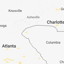
North Carolina
| Local Time | Report Details |
|---|---|
| 5:05 PM EDT | Several trees blown down near the intersection of route 67 and butner mill road in yadkin county NC, 71.1 miles NNE of Charlotte, NC |
| 7:40 PM EDT | Multiple trees reported down in alamance county... south of i-40 and 8 in alamance county NC, 50.2 miles WNW of Raleigh, NC |
| 8:00 PM EDT | Tree down on e king st and s cameron st in hillsborough. the tree took down power lines and caught on fir in orange county NC, 32.7 miles NW of Raleigh, NC |
| 8:00 PM EDT | Tree down blocking road at st marys rd and miller rd in hillsboroug in orange county NC, 31.8 miles NW of Raleigh, NC |
| 8:00 PM EDT | Several trees down across the southern part of rockingham county between 8pm and 10p in rockingham county NC, 67.6 miles S of Roanoke, VA |
| 8:05 PM EDT | Tree down on a power line on dick holeman r in person county NC, 37.8 miles NNW of Raleigh, NC |
| 8:41 PM EDT | One tree blown down along whitaker road in yadkin county NC, 64.8 miles N of Charlotte, NC |
| 8:46 PM EDT | One tree blown down near the intersection of gadberry road and rockford road in surry county NC, 71.6 miles N of Charlotte, NC |
| 8:51 PM EDT | One tree blown down along rockford road between the intersections of route 67 and nebo road in yadkin county NC, 69.5 miles N of Charlotte, NC |
| 8:57 PM EDT | One tree blown down on vallie davis drive just off route 67 in yadkin county NC, 70.1 miles N of Charlotte, NC |
| 8:59 PM EDT | Tree down on hillsboro st in oxfor in granville county NC, 36.2 miles N of Raleigh, NC |
| 9:03 PM EDT | A power line brought down by a small tree at deepwood dr and lakeside d in vance county NC, 37.9 miles NNE of Raleigh, NC |
| 9:04 PM EDT | Tree down on ruin creek r in vance county NC, 38.2 miles NNE of Raleigh, NC |
| 9:08 PM EDT | Tree down on east andrews av in vance county NC, 40.1 miles NNE of Raleigh, NC |
| 9:26 PM EDT | Tree down on reynolda rd and bethania r in forsyth county NC, 71.3 miles NNE of Charlotte, NC |
| 9:37 PM EDT | Tree down on warrenton rd in henderso in vance county NC, 41.8 miles NNE of Raleigh, NC |
| 9:43 PM EDT | Tree down on rankin mill rd and hines chapel r in guilford county NC, 64.4 miles WNW of Raleigh, NC |
| 9:56 PM EDT | 911 call center reported tree down along robinson church road in mecklenburg county NC, 8.4 miles E of Charlotte, NC |
| 9:57 PM EDT | 911 call center reported tree down along harrisburg road in mecklenburg county NC, 10.2 miles E of Charlotte, NC |
| 10:04 PM EDT | Public reported trees down in mint hill in mecklenburg county NC, 11 miles ESE of Charlotte, NC |
| 10:17 PM EDT | Tree down on glenwood rd and e kivett st in ashebor in randolph county NC, 65.9 miles W of Raleigh, NC |
| 10:22 PM EDT | Tree down at nc-22 s and stout acres r in randolph county NC, 56.2 miles W of Raleigh, NC |
| 10:25 PM EDT | Thunderstorm winds downed a tree near the intersection of nc42 e and doc hayworth road. time estimated via rada in randolph county NC, 56.4 miles W of Raleigh, NC |
Oklahoma
| Local Time | Report Details |
|---|---|
| 4:07 PM CDT | Measured at wiley post airport in oklahoma county OK, 7.8 miles WNW of Oklahoma City, OK |
| 4:07 PM CDT | 1 inch tree limbs down... shingles blown off roof in tulsa county OK, 14.3 miles NNE of Tulsa, OK |
| 4:44 PM CDT | 59 mph wind gust measured at tulsa international airpor in tulsa county OK, 4.3 miles ESE of Tulsa, OK |
| 4:45 PM CDT | Treee down on a home at 51st street and sheridan in tulsa county OK, 4.3 miles ESE of Tulsa, OK |
| 4:46 PM CDT | Large tree down on top of a truck at 109th east ave and 27th street in tulsa county OK, 4.3 miles ESE of Tulsa, OK |
| 4:54 PM CDT | Power poles down between 51st street and 41st street on s 209th e ave in tulsa county OK, 13.3 miles ESE of Tulsa, OK |
| 4:54 PM CDT | One inch tree limbs down in wagoner county OK, 13.3 miles ESE of Tulsa, OK |
| 4:55 PM CDT | Power out 41st street and county line road in tulsa county OK, 13.3 miles ESE of Tulsa, OK |
| 7:10 PM CDT | 2 broken power poles and 3 trees down in sequoyah county OK, 21.4 miles WNW of Fort Smith, AR |
Alabama
| Local Time | Report Details |
|---|---|
| 4:18 PM CDT | Large tree limbs down and some tin peeled from a roof of a traile in cullman county AL, 44.7 miles N of Birmingham, AL |
| 4:45 PM CDT | Trees down in the 500 block of 11th st. time estimated from rada in jefferson county AL, 12.1 miles NE of Birmingham, AL |
| 4:45 PM CDT | Corrects previous tstm wnd dmg report from 2 sse center point. trees down in the 1100 block of brewster rd. time estimated from rada in jefferson county AL, 11.1 miles NE of Birmingham, AL |
| 4:45 PM CDT | Corrects previous tstm wnd dmg report from 2 sse center point. trees down in the 1100 block of brewster rd. time estimated from rada in jefferson county AL, 11.1 miles NE of Birmingham, AL |
| 5:25 PM CDT | Power lines knocked dow in limestone county AL, 46.3 miles ESE of Florence, AL |
| 6:22 PM CDT | Tree down blocking egypt rd in the egypt community. time estimated from rada in etowah county AL, 53.8 miles NE of Birmingham, AL |
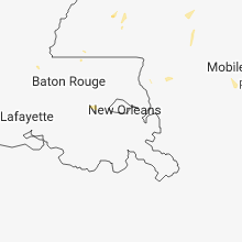
Louisiana
| Local Time | Report Details |
|---|---|
| 4:19 PM CDT | Social media pictures of minor damage to a chicken coop and shed near the leblanc community north of erath. time estimated by rada in vermilion county LA, 13.1 miles S of Lafayette, LA |
Massachusetts
| Local Time | Report Details |
|---|---|
| 5:20 PM EDT | Tree down blocking lake road in berkshire county MA, 42.1 miles SE of Schenectady, NY |
| 5:40 PM EDT | Trees and wires down near mountain road and clifford road in berkshire county MA, 45.6 miles SE of Schenectady, NY |
| 5:40 PM EDT | Large tree down blocking one lane in berkshire county MA, 44.4 miles SE of Schenectady, NY |
| 6:15 PM EDT | Tree down on a car on main road in berkshire county MA, 57.4 miles SE of Schenectady, NY |
| 7:00 PM EDT | Trees down in backyard on mount jefferson road in worcester county MA, 55 miles NW of Providence, RI |
| 7:05 PM EDT | Tree and wires down on west meadow road in middlesex county MA, 60.2 miles NNW of Providence, RI |
| 7:10 PM EDT | Large tree down on hollis street in middlesex county MA, 59.1 miles N of Providence, RI |
Ohio
| Local Time | Report Details |
|---|---|
| 5:24 PM EDT | Large tree down over road. time estimated by radar dat in scioto county OH, 71.4 miles ESE of Cincinnati, OH |
New Hampshire
| Local Time | Report Details |
|---|---|
| 5:30 PM EDT | Trees and wires down on kimball roa in belknap county NH, 58.3 miles W of Portland, ME |
| 5:30 PM EDT | Trees and wires down in keen in cheshire county NH, 83.8 miles E of Schenectady, NY |
| 5:30 PM EDT | Trees and utility poles dow in cheshire county NH, 84.5 miles E of Schenectady, NY |
| 6:28 PM EDT | *** 1 inj *** person at angle pond campground received a head injury from falling debris (limbs). relayed via amateur radi in rockingham county NH, 68.9 miles SW of Portland, ME |
Arkansas
| Local Time | Report Details |
|---|---|
| 4:50 PM CDT | A tree was blown down. winds were estimated at 60 mp in johnson county AR, 42.6 miles E of Fort Smith, AR |
| 4:54 PM CDT | Strong winds caused damage to power line in jackson county AR, 75 miles WNW of Memphis, TN |
| 4:55 PM CDT | Large limbs were blown down. wind gusts were estimated around 60 mp in logan county AR, 41.1 miles E of Fort Smith, AR |
| 5:30 PM CDT | Large tree reported down on a house on the eastern side of fayettevill in washington county AR, 48.8 miles NNE of Fort Smith, AR |
| 7:37 PM CDT | Shingles blown off roofs of 3 home in crawford county AR, 6.5 miles ENE of Fort Smith, AR |
Kentucky
| Local Time | Report Details |
|---|---|
| 5:50 PM EDT | Tree fell on moving vehicl in fayette county KY, 35.7 miles NW of Irvine, KY |
| 8:20 PM EDT | Multiple reports of trees down around the count in marion county KY, 38.9 miles SE of Louisville, KY |
| 7:48 PM CDT | Multiple trees dow in russell county KY, 71.7 miles SW of Irvine, KY |
| 8:28 PM CDT | Two trees reported dow in russell county KY, 77.7 miles SW of Irvine, KY |
South Carolina
| Local Time | Report Details |
|---|---|
| 5:50 PM EDT | 911 call center reported tree on chippewa court dwelling in oconee county SC, 18.5 miles WSW of Greenville, SC |
| 6:09 PM EDT | 911 call center reported trees and powerlines down along north bayshore drive. at least one tree on a dwellin in oconee county SC, 16.8 miles WSW of Greenville, SC |
Iowa
| Local Time | Report Details |
|---|---|
| 5:05 PM CDT | Report via social media. measured with home weather statio in black hawk county IA, 48.4 miles WNW of Cedar Rapids, IA |
Wyoming
| Local Time | Report Details |
|---|---|
| 4:05 PM MDT | Quarter sized hail reported near Cheyenne, WY, 41.5 miles ESE of Laramie, WY, mix of dimes... nickles and quarters. corrected for location. at the spradley barr dealer. |
| 8:28 PM MDT | Ping Pong Ball sized hail reported near Wheatland, WY, 55.1 miles W of Scottsbluff, NE |
| 9:06 PM MDT | Tennis Ball sized hail reported near Meriden, WY, 41.4 miles SW of Scottsbluff, NE, golfball to tennis ball sized hail reported near meriden on highway 85. |
New Jersey
| Local Time | Report Details |
|---|---|
| 6:48 PM EDT | Tree reported down at 58 ellison street time estimated by radar in passaic county NJ, 17.4 miles NNW of Brooklyn, NY |
| 6:58 PM EDT | Multiple tree limbs and branches down up to three inches in diameter. also had hail ranging from one quarter to three quarters of an inch in diamete in bergen county NJ, 18.5 miles NNW of Brooklyn, NY |
Mississippi
| Local Time | Report Details |
|---|---|
| 6:45 PM CDT | Two trees down at intersection of highway 28 east and bailey road...one tree was blocking highway 28. reported by copiah em in copiah county MS, 28.6 miles S of Jackson, MS |
| 7:04 PM CDT | Report of 5-6 trees down on monticello & beauregard road... with a tree on a powerline on each roa in copiah county MS, 38.3 miles S of Jackson, MS |
| 8:05 PM CDT | One tree was down. likely a sub-severe wind gus in jones county MS, 69.6 miles ESE of Jackson, MS |
Nebraska
| Local Time | Report Details |
|---|---|
| 6:57 PM CDT | Quarter sized hail reported near Stapleton, NE, 34.2 miles N of North Platte, NE |
| 4:36 AM CDT | Quarter sized hail reported near Oconto, NE, 50.4 miles E of North Platte, NE, report passed to us by neighboring nws office |
| 5:16 AM MDT | Quarter sized hail reported near Kimball, NE, 52 miles S of Scottsbluff, NE |
New Mexico
| Local Time | Report Details |
|---|---|
| 5:59 PM MDT | Hen Egg sized hail reported near , , 57.3 miles NE of Taos, NM, 15 miles west of raton on nm-555 |
| 8:15 PM MDT | Half Dollar sized hail reported near Maxwell, NM, 49.5 miles ENE of Taos, NM, roof damage reported. |
| 8:25 PM MDT | Golf Ball sized hail reported near Maxwell, NM, 53.1 miles ENE of Taos, NM, hail covering the ground. |
| 10:40 PM MDT | Mills canyon raw in harding county NM, 68.8 miles NNW of Tucumcari, NM |
| 1:46 AM MDT | K4mr awo in roosevelt county NM, 60.7 miles S of Tucumcari, NM |
Connect with Interactive Hail Maps