

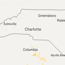
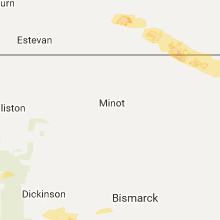
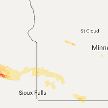
Hail Map for Wednesday, July 19, 2017

Number of Impacted Households on 7/19/2017
0
Impacted by 1" or Larger Hail
0
Impacted by 1.75" or Larger Hail
0
Impacted by 2.5" or Larger Hail
Square Miles of Populated Area Impacted on 7/19/2017
0
Impacted by 1" or Larger Hail
0
Impacted by 1.75" or Larger Hail
0
Impacted by 2.5" or Larger Hail


Cities Most Affected by Hail Storms of 7/19/2017
| Hail Size | Demographics of Zip Codes Affected | ||||||
|---|---|---|---|---|---|---|---|
| City | Count | Average | Largest | Pop Density | House Value | Income | Age |
| Atkinson, NE | 1 | 2.75 | 2.75 | 2 | $52k | $30.6k | 47.1 |
| Cavour, SD | 1 | 2.50 | 2.50 | 4 | $43k | $43.9k | 46.5 |
| Winnebago, IL | 1 | 1.75 | 1.75 | 105 | $120k | $64.1k | 39.8 |
| Saint John, ND | 1 | 1.75 | 1.75 | 6 | $62k | $29.2k | 34.4 |
Hail and Wind Damage Spotted on 7/19/2017
Filter by Report Type:Hail ReportsWind Reports
States Impacted
North Dakota, Montana, South Dakota, Nevada, South Carolina, Minnesota, Iowa, North Carolina, Nebraska, Arizona, Wisconsin, Pennsylvania, Georgia, New Mexico, Illinois, IndianaNorth Dakota
| Local Time | Report Details |
|---|---|
| 6:10 AM MDT | Quarter sized hail reported near Raleigh, ND, 48.8 miles SSW of Bismarck, ND, hail lasted from 710 am to 715 am. |
| 8:30 AM CDT | Golf Ball sized hail reported near Saint John, ND, 69.9 miles NNW of Devils Lake, ND, facebook post. |
| 8:50 AM CDT | Ping Pong Ball sized hail reported near Rocklake, ND, 56.3 miles NNW of Devils Lake, ND |
| 9:05 AM MDT | Quarter sized hail reported near Mott, ND, 64.8 miles WSW of Bismarck, ND |
Montana
| Local Time | Report Details |
|---|---|
| 6:35 AM MDT | Measured 58mph wind. nickel size hail in dawson county MT, 63.9 miles NNE of Miles City, MT |
South Dakota
| Local Time | Report Details |
|---|---|
| 7:30 AM MDT | Storm damage reported in corson county SD, 74.5 miles S of Bismarck, ND |
| 8:04 AM MDT | Storm damage reported in corson county SD, 81.6 miles NNW of Pierre, SD |
| 9:08 AM CDT | 50 to 60 mph wind gusts... crop damage from hail and/or wind... and some trees dow in campbell county SD, 85.4 miles SSE of Bismarck, ND |
| 9:15 AM CDT | Sheriff reported wind gusts of 60-70 mp in walworth county SD, 75 miles W of Aberdeen, SD |
| 9:21 AM CDT | Quarter sized hail reported near Selby, SD, 75 miles W of Aberdeen, SD, ground covered with hail including numerous quarter size hailstones. wind gusts of 60-70 mph. |
| 9:40 AM CDT | Storm damage reported in walworth county SD, 62.8 miles W of Aberdeen, SD |
| 9:48 AM CDT | Storm damage reported in potter county SD, 48.5 miles NNE of Pierre, SD |
| 9:53 AM CDT | Storm damage reported in walworth county SD, 67.3 miles N of Pierre, SD |
| 10:01 AM CDT | Storm damage reported in potter county SD, 51.1 miles NNE of Pierre, SD |
| 10:20 AM CDT | Significant tree damage... damage to property... will provide additional details at a later tim in hyde county SD, 52.8 miles ENE of Pierre, SD |
| 10:20 AM CDT | 3 or 4 grain bins destroyed... a few miles north of this location... trailer homes that were being moved were blown off of moving trailer in hyde county SD, 53.5 miles NE of Pierre, SD |
| 10:21 AM CDT | A few small trees knocked ove in hyde county SD, 53.4 miles NE of Pierre, SD |
| 10:22 AM CDT | Measured at rwis station at the intersection of sd47 and sd2 in hyde county SD, 52.7 miles ENE of Pierre, SD |
| 10:24 AM CDT | Winds knocked down an 18 inch in diameter tre in hyde county SD, 52.8 miles ENE of Pierre, SD |
| 10:30 AM CDT | 50 to 60 mph winds. heavy rain reducing visibility and making travel difficult. some ponding of water in ditche in edmunds county SD, 30.1 miles WSW of Aberdeen, SD |
| 10:40 AM CDT | Trailer with empty tanks tipped... pontoon on trailer tipped... tree branches greater than 8" in diameter downe in hand county SD, 62.3 miles ENE of Pierre, SD |
| 10:51 AM CDT | One inch in diameter tree branches broken of in hand county SD, 66.6 miles SSW of Aberdeen, SD |
| 11:36 AM CDT | Also nickel size hai in beadle county SD, 72.1 miles SSE of Aberdeen, SD |
| 11:36 AM CDT | Storm damage reported in beadle county SD, 74.3 miles S of Aberdeen, SD |
| 11:47 AM CDT | Irrigation pivots damage in beadle county SD, 72.6 miles SSE of Aberdeen, SD |
| 11:52 AM CDT | Storm damage reported in beadle county SD, 78.6 miles SSE of Aberdeen, SD |
| 12:03 PM CDT | Tennis Ball sized hail reported near Cavour, SD, 82.3 miles NW of Sioux Falls, SD, golf ball to tennis ball size. |
| 12:30 PM CDT | Storm damage reported in beadle county SD, 74.3 miles S of Aberdeen, SD |
| 1:05 PM CDT | Storm damage reported in brookings county SD, 54.2 miles N of Sioux Falls, SD |
| 1:30 PM CDT | Large barn and grain bin destroyed. power poles and several trees blown over. report via social medi in brookings county SD, 53.3 miles SW of Montevideo, MN |
| 3:35 PM CDT | Storm damage reported in tripp county SD, 47.4 miles ENE of Valentine, NE |
| 4:10 PM CDT | Quarter sized hail reported near Dallas, SD, 53.5 miles ENE of Valentine, NE, about a 1/2 of rain in 30 minutes. |
| 4:15 PM CDT | Quarter sized hail reported near Dallas, SD, 59.2 miles ENE of Valentine, NE |
| 5:10 PM CDT | Quarter sized hail reported near Mission, SD, 29.5 miles N of Valentine, NE |
Nevada
| Local Time | Report Details |
|---|---|
| 7:15 AM PDT | Tree fell over through roof of house. time estimated. wind speeds estimated between 30-50 mp in clark county NV, 8.7 miles SSE of Las Vegas, NV |
South Carolina
| Local Time | Report Details |
|---|---|
| 1:52 PM EDT | Public reported a tree down blocking both lanes of highway 21 n. time estimated based on rada in fairfield county SC, 59.1 miles S of Charlotte, NC |
| 2:38 PM EDT | Tree and power line down on farmstead lane near the intersection of langley road. time estimated based on rada in orangeburg county SC, 50.8 miles WNW of Charleston, SC |
| 3:28 PM EDT | Sumter county dispatch reported tree down on hidden bay drive. time estimated based on rada in sumter county SC, 55.1 miles NNW of Charleston, SC |
| 3:40 PM EDT | Edisto electric coop reported a small tree down on powerlines near ehrhard in bamberg county SC, 58.2 miles W of Charleston, SC |
| 3:42 PM EDT | Sumter co. dispatch reported tree down at mccray's mill road and guignard rd. time estimated based on rada in sumter county SC, 52.9 miles NNW of Charleston, SC |
| 3:49 PM EDT | Sumter county dispatch reported a tree down at 255 ott street. time estimated based on rada in sumter county SC, 53 miles NNW of Charleston, SC |
| 3:50 PM EDT | Sumter county dispatch reported a tree down on red bay rd. at lafayette dr. time estimated based on rada in sumter county SC, 52 miles NNW of Charleston, SC |
| 3:50 PM EDT | Highway patrol reported trees down on paxville hwy at ethan stone rd. time estimated by rada in clarendon county SC, 42.8 miles NNW of Charleston, SC |
| 4:00 PM EDT | Clarendon county dispatch reported a tree on a house and powerlines on old manning road. time estimated based on rada in clarendon county SC, 38.4 miles NNW of Charleston, SC |
| 4:40 PM EDT | Sumter dispatch reported tree down on interstate 95 at mile marker 139 northbound. time estimated based on rada in sumter county SC, 53.3 miles N of Charleston, SC |
| 5:02 PM EDT | Quarter sized hail reported near Hanahan, SC, 19.7 miles S of Charleston, SC, a trained spotter reports quarter sized hail in the 1200 block of hawthorne circle. |
| 5:05 PM EDT | Quarter sized hail reported near Mount Pleasant, SC, 25.1 miles SSE of Charleston, SC, an off duty nws employee reports hail up to the size of quarters on i-526. |
| 5:07 PM EDT | Half Dollar sized hail reported near Hanahan, SC, 18.4 miles S of Charleston, SC, a twitter user sent a picture of a hail stone larger than a quarter from 1000 channel marker way. |
| 5:09 PM EDT | Quarter sized hail reported near Charleston, SC, 20.5 miles S of Charleston, SC, trained spotter reported 1 inch hail falling near the intersection of north rhett ave and remount road. |
| 5:10 PM EDT | A public report of trees and large tree limbs down on evergreen magnolia avenu in berkeley county SC, 11.5 miles S of Charleston, SC |
| 5:14 PM EDT | Half Dollar sized hail reported near Hanahan, SC, 19.1 miles S of Charleston, SC, a public report of pea to half dollar sized hail in hanahan. report relayed the nws gsp office. |
| 5:20 PM EDT | South carolina highway patrol reported a tree down on highway 52 near the strawberry are in berkeley county SC, 9.5 miles S of Charleston, SC |
| 6:55 PM EDT | County official reports trees and powerlines blown dow in york county SC, 22.3 miles SSW of Charlotte, NC |
Minnesota
| Local Time | Report Details |
|---|---|
| 1:31 PM CDT | Storm damage reported in lincoln county MN, 54.1 miles NNE of Sioux Falls, SD |
| 1:45 PM CDT | Tree branches dow in lincoln county MN, 54 miles NNE of Sioux Falls, SD |
| 2:20 PM CDT | Tree dow in nicollet county MN, 71 miles SW of Minneapolis, MN |
| 2:38 PM CDT | Storm damage reported in cottonwood county MN, 74.1 miles SSE of Montevideo, MN |
| 2:48 PM CDT | Corn fields flattened. several trees down. one tree uprooted. one tree snapped of in brown county MN, 67 miles SSE of Montevideo, MN |
| 2:48 PM CDT | Trees dow in brown county MN, 70.8 miles SE of Montevideo, MN |
| 2:50 PM CDT | Numerous trees uprooted/snapped off. damage to corn fields nearby as well. time estimate in brown county MN, 65.1 miles SSE of Montevideo, MN |
| 3:00 PM CDT | Empty semi trailer tipped over. reported at county road 8 and county road 18... comfrey... m in brown county MN, 73.2 miles SE of Montevideo, MN |
| 3:10 PM CDT | Large tree blown dow in watonwan county MN, 85.4 miles SE of Montevideo, MN |
| 3:12 PM CDT | Power lines dow in brown county MN, 77.3 miles SW of Minneapolis, MN |
| 3:15 PM CDT | Mesonet station mn045... madelia 3en in blue earth county MN, 82.7 miles SW of Minneapolis, MN |
| 3:42 PM CDT | Two trees down along county line roa in waseca county MN, 66.9 miles SSW of Minneapolis, MN |
| 3:42 PM CDT | Tree dow in waseca county MN, 63.3 miles SSW of Minneapolis, MN |
| 3:50 PM CDT | Numerous trees dow in blue earth county MN, 66.3 miles SSW of Minneapolis, MN |
| 3:55 PM CDT | Storm damage reported in blue earth county MN, 68.7 miles NNW of Mason City, IA |
| 3:55 PM CDT | Several trees down along hwy 1 in rice county MN, 36.8 miles S of Minneapolis, MN |
| 4:15 PM CDT | Tree dow in steele county MN, 61.4 miles S of Minneapolis, MN |
| 4:18 PM CDT | Trees dow in steele county MN, 61.5 miles S of Minneapolis, MN |
| 4:30 PM CDT | Damage to turkey farm and power lines. time and location estimated based on rada in dodge county MN, 63.4 miles SSE of Minneapolis, MN |
| 4:35 PM CDT | Trees uprooted and roof blown off of building. time estimated based on rada in dodge county MN, 64 miles SSE of Minneapolis, MN |
| 4:35 PM CDT | Power out in dodge county MN, 62.5 miles N of Mason City, IA |
| 4:35 PM CDT | Building damage reported in dodge county MN, 64.4 miles SSE of Minneapolis, MN |
| 5:00 PM CDT | Storm damage reported in olmsted county MN, 61.6 miles WNW of La Crosse, WI |
| 5:30 PM CDT | Power lines dow in winona county MN, 41.8 miles WNW of La Crosse, WI |
| 5:38 PM CDT | Trees down near highway 14 and county road 3 in winona county MN, 37.5 miles WNW of La Crosse, WI |
| 12:47 AM CDT | Quarter sized hail reported near Windom, MN, 80.3 miles SSE of Montevideo, MN |
| 12:48 AM CDT | Ping Pong Ball sized hail reported near Windom, MN, 80.3 miles SSE of Montevideo, MN |
Iowa
| Local Time | Report Details |
|---|---|
| 3:55 PM CDT | Estimated 60 to 65 mph winds. lots of small branches dow in kossuth county IA, 62 miles WNW of Mason City, IA |
| 3:57 PM CDT | Public relayed pictures via twitter of trees snapped and other tree damage in ledyard area. time estimated by radar. delayed repor in kossuth county IA, 51.9 miles WNW of Mason City, IA |
| 4:01 PM CDT | County dispatch reported trees and power lines down. time estimated by radar. delayed repor in winnebago county IA, 42.9 miles WNW of Mason City, IA |
| 4:07 PM CDT | County dispatch reported multiple trees down and power line damage in town. time estimated by radar. delayed repor in winnebago county IA, 40.9 miles WNW of Mason City, IA |
| 4:15 PM CDT | Evergreen tree uprooted in yard. time estimated from rada in winnebago county IA, 32.6 miles WNW of Mason City, IA |
| 4:23 PM CDT | County dispatch reported multiple broken windows... power lines down... and trees downed in down. time estimated by radar. delayed repor in winnebago county IA, 23.5 miles WNW of Mason City, IA |
| 4:23 PM CDT | County dispatch reported multiple trees down and power line damage in town. time estimated by radar. delayed repor in winnebago county IA, 25.5 miles WNW of Mason City, IA |
| 4:25 PM CDT | County dispatch reported trees down in town. time estimated by radar. delayed repor in winnebago county IA, 25.1 miles NW of Mason City, IA |
| 4:33 PM CDT | County dispatch reported trees down and power outages in town. time estimated by radar. delayed repor in worth county IA, 13.5 miles NW of Mason City, IA |
| 4:33 PM CDT | County dispatch reported overturned semis along i-35 at/around mile markers 203... 205... 207... 208. between hanlontown and 410th st. time estimated by radar. delayed in worth county IA, 14.1 miles NNW of Mason City, IA |
| 4:35 PM CDT | 57 knot/66 mph wind gust at forest city airpor in hancock county IA, 22.1 miles WNW of Mason City, IA |
| 4:35 PM CDT | Storm damage reported in hancock county IA, 22.6 miles WNW of Mason City, IA |
| 4:37 PM CDT | Emergency manager reports semis blown over on i-35 near highway 9. time estimated from rada in worth county IA, 12.4 miles NW of Mason City, IA |
| 4:39 PM CDT | Dispatch reported numerous trees down... and power lines down. time estimated by radar. delayed repor in cerro gordo county IA, 8.6 miles W of Mason City, IA |
| 4:39 PM CDT | County dispatch reported transformer blown... power lines and poles down... and tree damage. time estimated by radar. delayed repor in worth county IA, 20.3 miles N of Mason City, IA |
| 4:40 PM CDT | County dispatch reported significant tree damage in town. time estimated by radar. delayed repor in worth county IA, 14 miles N of Mason City, IA |
| 4:40 PM CDT | Hanlontown rwis recorded a 60 mph wind gus in worth county IA, 11.9 miles NW of Mason City, IA |
| 4:41 PM CDT | County dispatch reported multiple trees down in manly. time estimated by radar. delayed repor in worth county IA, 9.9 miles N of Mason City, IA |
| 4:45 PM CDT | Recorded 63 mph wind gust at mason city municipa in cerro gordo county IA, 7 miles W of Mason City, IA |
| 4:46 PM CDT | Emergency manager reports multiple locations with trees down in mason city. time estimated from rada in cerro gordo county IA, 0.2 miles NNE of Mason City, IA |
| 4:48 PM CDT | Trees down in plymouth via social media report. time estimated from rada in cerro gordo county IA, 7.6 miles NNE of Mason City, IA |
| 4:53 PM CDT | Storm damage reported in floyd county IA, 9.8 miles E of Mason City, IA |
| 4:53 PM CDT | Storm damage reported in floyd county IA, 10.1 miles ENE of Mason City, IA |
| 4:56 PM CDT | Storm damage reported in floyd county IA, 15.3 miles E of Mason City, IA |
| 4:57 PM CDT | Storm damage reported in mitchell county IA, 21.8 miles ENE of Mason City, IA |
| 4:59 PM CDT | Widespread tree damage reported. 6 to 8 inch diameter trees down. estimated 70 to 80 mph winds. time estimated based on rada in mitchell county IA, 22.1 miles ENE of Mason City, IA |
| 5:00 PM CDT | Healthy 5-6" diameter tree snapped at base... downed power lines. time estimated from rada in mitchell county IA, 23.8 miles NE of Mason City, IA |
| 5:00 PM CDT | Tree damage reported in osage. estimated wind gusts of 70 mp in mitchell county IA, 21.8 miles ENE of Mason City, IA |
| 5:00 PM CDT | Numerous trees down in nora spring in floyd county IA, 10.2 miles E of Mason City, IA |
| 5:01 PM CDT | Multiple trees dow in mitchell county IA, 21.8 miles ENE of Mason City, IA |
| 5:07 PM CDT | Storm damage reported in floyd county IA, 26.9 miles E of Mason City, IA |
| 5:12 PM CDT | Tree branches dow in floyd county IA, 30.9 miles E of Mason City, IA |
| 5:20 PM CDT | Widespread tree damage... one tree laying on power line in chickasaw county IA, 39.6 miles E of Mason City, IA |
| 5:20 PM CDT | Reported from schoolnet site in tow in chickasaw county IA, 45.5 miles E of Mason City, IA |
| 5:27 PM CDT | Power lines down along / near highway 24 in chickasaw county IA, 47.8 miles E of Mason City, IA |
| 5:35 PM CDT | Trees blown down in fayette county IA, 59.5 miles E of Mason City, IA |
| 5:40 PM CDT | Numerous trees down in spillville. time estimated from rada in winneshiek county IA, 54.9 miles SW of La Crosse, WI |
| 5:41 PM CDT | Trees blown down in fayette county IA, 60.6 miles SSW of La Crosse, WI |
| 5:45 PM CDT | Twitter report shared from kwwl of trees and power lines down in sumner. time estimated by rada in bremer county IA, 59.4 miles ESE of Mason City, IA |
| 5:47 PM CDT | Power lines down across the town of cresc in howard county IA, 53.2 miles SW of La Crosse, WI |
| 5:49 PM CDT | Trees down in fayette county IA, 59.6 miles SSW of La Crosse, WI |
| 5:52 PM CDT | 2 ft diameter trees dow in winneshiek county IA, 51.2 miles SW of La Crosse, WI |
| 6:03 PM CDT | Lots of trees and power lines down. corn also impacted. damage continued toward mcgrego in clayton county IA, 53.1 miles S of La Crosse, WI |
| 6:10 PM CDT | Large tree branch blown down. also 1 inch of rai in delaware county IA, 47.9 miles NNE of Cedar Rapids, IA |
| 6:12 PM CDT | Part of a roof removed from an outbuilding and corn pushed over. time estimated based on radar. received via social medi in allamakee county IA, 39.2 miles SSW of La Crosse, WI |
| 6:14 PM CDT | Corn blown down. shed damage. tree blown on hous in allamakee county IA, 42.1 miles SSW of La Crosse, WI |
| 6:15 PM CDT | Trees snapped or uprooted in winneshiek county IA, 43.2 miles SSW of La Crosse, WI |
| 6:55 PM CDT | Storm damage reported in delaware county IA, 51.8 miles NNE of Cedar Rapids, IA |
| 6:59 PM CDT | Numerous reports of branches and few trees down in the city of dubuqu in dubuque county IA, 62.1 miles NE of Cedar Rapids, IA |
| 7:38 PM CDT | Estimated around 40 mph with 1.5 inch diameter branches dow in jackson county IA, 52 miles E of Cedar Rapids, IA |
North Carolina
| Local Time | Report Details |
|---|---|
| 5:54 PM EDT | Roof blown off building on spring meadow drive. trees knocked down across sassafras lane and potneck roa in rowan county NC, 40.4 miles NNE of Charlotte, NC |
Nebraska
| Local Time | Report Details |
|---|---|
| 5:00 PM CDT | Large tree branches and power lines downed. relayed via social media in holt county NE, 32.8 miles NW of Oneill, NE |
| 5:45 PM CDT | Ping Pong Ball sized hail reported near Atkinson, NE, 17.6 miles WNW of Oneill, NE |
| 6:00 PM CDT | Trees downed and building damage in holt county NE, 17.6 miles WNW of Oneill, NE |
| 6:47 PM CDT | Quarter sized hail reported near Oneill, NE, 6.3 miles W of Oneill, NE |
| 7:14 PM CDT | Baseball sized hail reported near Atkinson, NE, 24.9 miles WSW of Oneill, NE, hail ranged from quarters to baseball size |
| 7:26 PM CDT | Quarter sized hail reported near Atkinson, NE, 25.2 miles WSW of Oneill, NE, heavy rain reported as well |
Arizona
| Local Time | Report Details |
|---|---|
| 3:19 PM MST | Tree down in eastbound lane at i-10 and tangerine road in pima county AZ, 17.6 miles NW of Tucson, AZ |
| 3:45 PM MST | Palo verde uprooted along kino parkway in pima county AZ, 1.9 miles SE of Tucson, AZ |
| 3:45 PM MST | Large tree down near stone/6th s in pima county AZ, 1.3 miles ENE of Tucson, AZ |
| 4:17 PM MST | Large tree down on two cars at mckale center on university of arizona campus in pima county AZ, 1.3 miles ENE of Tucson, AZ |
| 4:25 PM MST | Tree down at 22nd street and euclid avenue in pima county AZ, 1 miles SE of Tucson, AZ |
| 4:48 PM MST | Large tree down at park avenue and 19th street in pima county AZ, 1 miles SE of Tucson, AZ |
| 5:08 PM MST | Large tree down at park avenue and 22nd street in pima county AZ, 1 miles SE of Tucson, AZ |
| 5:10 PM MST | Quarter sized hail reported near Sedona, AZ, 24.9 miles SSW of Flagstaff, AZ, public reports quarter size hail. storm total .75 in of rain. |
| 5:25 PM MST | Tree down at 5th street and echols avenue in pima county AZ, 0.6 miles N of Tucson, AZ |
| 5:48 PM MST | Power pole down at speedway blvd and i-10 in pima county AZ, 1.4 miles NNW of Tucson, AZ |
Wisconsin
| Local Time | Report Details |
|---|---|
| 5:40 PM CDT | Two large trees down blocking road. reported at 3443 crescent ave... eau claire... w in eau claire county WI, 69.2 miles NNW of La Crosse, WI |
| 6:20 PM CDT | Hanger damaged at airport. time estimate in crawford county WI, 55.2 miles S of La Crosse, WI |
| 6:20 PM CDT | Trees down and corn damage just east of prairie du chie in crawford county WI, 53 miles S of La Crosse, WI |
| 6:25 PM CDT | Storm damage reported in grant county WI, 61.9 miles SSE of La Crosse, WI |
| 6:25 PM CDT | Storm damage reported in crawford county WI, 28 miles S of La Crosse, WI |
| 6:27 PM CDT | Shed damaged. 4-wheeler blown over from extreme wind in grant county WI, 60.2 miles SSE of La Crosse, WI |
| 6:28 PM CDT | Several pine tree limbs damaged. top 6 feet of a 25 ft tall pine tree broken or twisted off and flung several fee in crawford county WI, 53.6 miles S of La Crosse, WI |
| 6:34 PM CDT | Large branches down in village. time estimate in vernon county WI, 10.7 miles S of La Crosse, WI |
| 6:41 PM CDT | Large branches down along south ave in la crosse county WI, 4.3 miles S of La Crosse, WI |
| 6:45 PM CDT | Tree limbs down. size was up to 6 inches in diameter. numerous limbs dow in vernon county WI, 7.9 miles SE of La Crosse, WI |
| 6:47 PM CDT | Trees damage in grant county WI, 60.2 miles SSE of La Crosse, WI |
| 6:49 PM CDT | Trees/powerlines down. significant damage. power outage in grant county WI, 68.8 miles WSW of Madison, WI |
| 6:50 PM CDT | Storm damage reported in grant county WI, 60 miles WSW of Madison, WI |
| 6:50 PM CDT | Storm damage reported in grant county WI, 60.3 miles WSW of Madison, WI |
| 6:50 PM CDT | Estimated 65 mph win in lafayette county WI, 53.6 miles WSW of Madison, WI |
| 6:51 PM CDT | Branches dow in la crosse county WI, 1.6 miles E of La Crosse, WI |
| 6:51 PM CDT | Trees and power lines down in vernon county WI, 35.1 miles SE of La Crosse, WI |
| 6:55 PM CDT | Tree damage... including an oak falling on power lines. time estimated from rada in grant county WI, 61.4 miles WSW of Madison, WI |
| 7:00 PM CDT | Trees and power lines dow in grant county WI, 54.9 miles SE of La Crosse, WI |
| 7:13 PM CDT | Trees and power lines down in vernon county WI, 34.6 miles ESE of La Crosse, WI |
| 7:16 PM CDT | Power lines down and large tree branches down in cobb and mineral poin in iowa county WI, 48.3 miles W of Madison, WI |
| 7:18 PM CDT | Trees and power lines down in the western part of lafayette county. no other details availabl in lafayette county WI, 53.1 miles WSW of Madison, WI |
| 7:19 PM CDT | Trees and power lines down in the western part of iowa county. no other details availabl in iowa county WI, 47.8 miles W of Madison, WI |
| 7:25 PM CDT | Trees and power lines dow in richland county WI, 47.1 miles WNW of Madison, WI |
| 7:34 PM CDT | Delayed report. trees and power lines down. time estimated from rada in iowa county WI, 27.1 miles WNW of Madison, WI |
| 7:35 PM CDT | Trees and power lines down in far western portions of sauk county with line of storms. time estimated from rada in sauk county WI, 47.3 miles NW of Madison, WI |
| 7:42 PM CDT | Trees and power lines down in multiple areas of green count in green county WI, 30.3 miles SSW of Madison, WI |
| 7:45 PM CDT | Greater than 2 inch diameter tree branches down. heavy downpour with high winds. rain was horizontal at times. rainfall of 0.50-0.74 inches in 15 minute in dane county WI, 16.4 miles SSW of Madison, WI |
| 7:47 PM CDT | Trees down in monro in green county WI, 34.4 miles SSW of Madison, WI |
| 7:59 PM CDT | Large branches falling in town in richland county WI, 53.4 miles WNW of Madison, WI |
| 8:00 PM CDT | 8 inch maple knocked down with gust behind the storms in portage county WI, 62.9 miles W of Green Bay, WI |
| 8:06 PM CDT | Several trees and branches down throughout rock county. time of event estimated from weather rada in rock county WI, 39.3 miles SSE of Madison, WI |
| 8:40 PM CDT | Couple docks and a boatlift damaged along lake poygan. estimated wind gusts to 50 mph in winnebago county WI, 47.6 miles WSW of Green Bay, WI |
| 8:50 PM CDT | Trees down in waushara county WI, 66.4 miles N of Madison, WI |
| 8:50 PM CDT | Tree down across the road in waushara county WI, 73.2 miles N of Madison, WI |
| 8:50 PM CDT | Tree across road in waushara county WI, 64.8 miles WSW of Green Bay, WI |
| 9:15 PM CDT | Delayed report. tree downed. unknown size in calumet county WI, 34.8 miles SSW of Green Bay, WI |
| 9:17 PM CDT | Tree down downtown. 911 center on backup generator in calumet county WI, 34.2 miles SSW of Green Bay, WI |
| 11:35 PM CDT | Power line down. time estimated from rada in buffalo county WI, 47.5 miles NW of La Crosse, WI |
Pennsylvania
| Local Time | Report Details |
|---|---|
| 6:50 PM EDT | 30 trees down through marysville rye and penn townshi in perry county PA, 58.1 miles ESE of State College, PA |
| 7:21 PM EDT | Trees and wires dow in cumberland county PA, 62.1 miles SE of State College, PA |
Georgia
| Local Time | Report Details |
|---|---|
| 7:12 PM EDT | Trees and powerlines down on west currahee stree in stephens county GA, 48.2 miles WSW of Greenville, SC |
| 7:34 PM EDT | Effingham county dispatch reported a tree down on midland road near highway 17. the tree came down due to thunderstorm outflo in effingham county GA, 22.3 miles NW of Savannah, GA |
| 7:45 PM EDT | Local media relayed a report of multiple trees down in the dashers landing subdivision near rincon. report was received via twitte in effingham county GA, 16 miles NNW of Savannah, GA |
| 8:10 PM EDT | Bryan county dispatch reported a large tree branch down on toni branch road. branch came down in the outflow ahead of the thunderstor in bryan county GA, 24.3 miles W of Savannah, GA |
New Mexico
| Local Time | Report Details |
|---|---|
| 5:43 PM MDT | Amateur radio operator had east facing windows blown out at his hous in luna county NM, 52 miles SE of Silver City, NM |
| 5:45 PM MDT | Tractor trailer overturned by thunderstorm outflow on highway 11 south of demin in luna county NM, 52.6 miles SE of Silver City, NM |
| 5:49 PM MDT | Aerostat balloon site measured a 61 mph wind gus in luna county NM, 56.8 miles SSE of Silver City, NM |
| 6:35 PM MDT | Thunderstorm outflow resulted in numerous large trees downed... two sheds blown over and roof blown off restauran in sierra county NM, 65.3 miles ENE of Silver City, NM |
| 7:10 PM MDT | Downed power line in lordsburg on south main street in hidalgo county NM, 38.6 miles SW of Silver City, NM |
| 7:30 PM MDT | Wind gust to 60 mph with low visibility from blowing dus in hidalgo county NM, 60.4 miles NE of Douglas, AZ |
Illinois
| Local Time | Report Details |
|---|---|
| 7:25 PM CDT | 1 foot diamter silver maple tree branch downed by stor in jo daviess county IL, 50.5 miles SSW of Madison, WI |
| 7:26 PM CDT | Estimated 50-55 mph with 2 inch branches dow in jo daviess county IL, 50.5 miles SSW of Madison, WI |
| 7:38 PM CDT | Estimated 70 mph winds with branches blowing across the roa in stephenson county IL, 43.6 miles SSW of Madison, WI |
| 7:43 PM CDT | Winds may be gusting as high as 80 mp in stephenson county IL, 55.4 miles SSW of Madison, WI |
| 7:48 PM CDT | Tree limbs down and power out in the south part of freeport. winds estimated at 60 mp in stephenson county IL, 55.2 miles SSW of Madison, WI |
| 8:13 PM CDT | Storm damage reported in winnebago county IL, 57.9 miles SSE of Madison, WI |
| 8:13 PM CDT | Reports of trees down... and power is ou in ogle county IL, 68 miles S of Madison, WI |
| 8:24 PM CDT | Powerlines down in machesney par in winnebago county IL, 52.3 miles SSE of Madison, WI |
| 8:30 PM CDT | 6 inch willow tree branch broke off towards the top of a tre in lee county IL, 81.9 miles W of Chicago, IL |
| 8:30 PM CDT | 6 inch willow tree branch broke off towards the top of a tre in lee county IL, 81.9 miles W of Chicago, IL |
| 8:35 PM CDT | Power out in the monroe center with multiple lines down in ne ogle count in ogle county IL, 69.6 miles SSE of Madison, WI |
| 8:40 PM CDT | 70 mph wind gust at boone county fairground in boone county IL, 63 miles SSE of Madison, WI |
| 8:49 PM CDT | 70 mph gust with 50+ mph sustained wind in de kalb county IL, 57.7 miles W of Chicago, IL |
| 8:49 PM CDT | 6 inch willow tree branch broke off towards the top of a tre in lee county IL, 81.9 miles W of Chicago, IL |
| 8:50 PM CDT | Tree down on house on n 12th street... other trees and powerlines down in the city of de kal in de kalb county IL, 57.7 miles W of Chicago, IL |
| 8:56 PM CDT | Large tree down on highway 23 south of marengo near county line. time estimate in mchenry county IL, 55.5 miles WNW of Chicago, IL |
| 9:30 PM CDT | Large tree down on a house in napervill in dupage county IL, 28.1 miles WSW of Chicago, IL |
| 9:32 PM CDT | 6 inch limbs down near w ave and raynor. time is radar estimate in will county IL, 35.1 miles SW of Chicago, IL |
| 9:32 PM CDT | 6 inch limbs down near w ave and raynor. time is radar estimate in will county IL, 35.1 miles SW of Chicago, IL |
| 9:40 PM CDT | Power lines down near near 3rd street in streator from outflow boundary wind in la salle county IL, 49.9 miles NE of Peoria, IL |
| 3:58 AM CDT | Golf Ball sized hail reported near Winnebago, IL, 55.9 miles S of Madison, WI |
Indiana
| Local Time | Report Details |
|---|---|
| 10:45 PM CDT | Power lines down and tree branches down onto power lines near county road 900 s and state road 2. time estimate in porter county IN, 46.1 miles SSE of Chicago, IL |
Connect with Interactive Hail Maps