

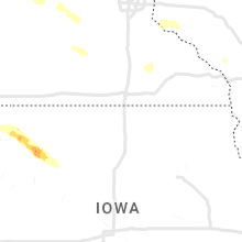
Hail Map for Tuesday, July 25, 2023

Number of Impacted Households on 7/25/2023
0
Impacted by 1" or Larger Hail
0
Impacted by 1.75" or Larger Hail
0
Impacted by 2.5" or Larger Hail
Square Miles of Populated Area Impacted on 7/25/2023
0
Impacted by 1" or Larger Hail
0
Impacted by 1.75" or Larger Hail
0
Impacted by 2.5" or Larger Hail


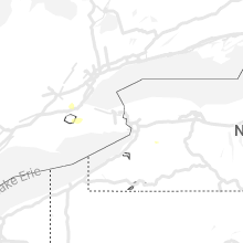


Cities Most Affected by Hail Storms of 7/25/2023
| Hail Size | Demographics of Zip Codes Affected | ||||||
|---|---|---|---|---|---|---|---|
| City | Count | Average | Largest | Pop Density | House Value | Income | Age |
| Arthur, IL | 1 | 2.50 | 2.50 | 75 | $71k | $38.8k | 31.8 |
Hail and Wind Damage Spotted on 7/25/2023
Filter by Report Type:Hail ReportsWind Reports
States Impacted
Pennsylvania, Maryland, New York, New Jersey, Virginia, Massachusetts, Ohio, Colorado, Delaware, Tennessee, Connecticut, Florida, Maine, Georgia, Kentucky, Wisconsin, South Dakota, North Dakota, Minnesota, Illinois, Kansas, Indiana, IowaPennsylvania
| Local Time | Report Details |
|---|---|
| 12:18 PM EDT | Quarter sized hail reported near Green Lane, PA, 74.5 miles S of Scranton, PA, quarter size hail report near green lane. power in the area is also out. |
| 12:40 PM EDT | Wires down with brush on fire near the intersection of bethlehem pike/rte 309 and rich hill road. time estimated from rada in bucks county PA, 71 miles SSE of Scranton, PA |
| 12:58 PM EDT | Tree down on wires in franklin township. time estimated from rada in carbon county PA, 38.7 miles S of Scranton, PA |
| 1:00 PM EDT | Quarter sized hail reported near Lehighton, PA, 38 miles S of Scranton, PA, driver observed 1 inch hail at mile marker 77 on i-476/pa turnpike northeast extension. |
| 1:27 PM EDT | Trees down at kennel and mcilhaney roads in chestnuthill township. time estimated from rada in monroe county PA, 36.7 miles SSE of Scranton, PA |
| 1:27 PM EDT | Report from mping: trees uprooted or snapped; roof blown off. time estimated from rada in montgomery county PA, 72.8 miles S of Scranton, PA |
| 1:35 PM EDT | Trees down along route 209 in hamilton township. time estimated from rada in monroe county PA, 37.2 miles SSE of Scranton, PA |
| 1:35 PM EDT | Trees down at hamilton elementary school in hamilton township. time estimated from rada in monroe county PA, 38.5 miles SSE of Scranton, PA |
| 1:35 PM EDT | Trees down at twin pine and running valley roads in jackson township. time estimated from rada in monroe county PA, 34.9 miles SSE of Scranton, PA |
| 1:48 PM EDT | Trees down at quaker alley and n 6th street in stroudsburg. time estimated from rada in monroe county PA, 38 miles SE of Scranton, PA |
| 3:22 PM EDT | Reports of several trees down on taylor road between downingtown and exto in chester county PA, 72.1 miles NE of Baltimore, MD |
Maryland
| Local Time | Report Details |
|---|---|
| 12:30 PM EDT | A couple reports of trees... branches... and wires down in the edgemere are in baltimore county MD, 10 miles ESE of Baltimore, MD |
| 12:58 PM EDT | A couple trees... large branches... and wires down between capitol heights and forestvill in prince georges county MD, 34.4 miles SSW of Baltimore, MD |
| 2:14 PM EDT | Wunderground station kmdsteve76 measured wind gust of 59.3mp in queen anne's county MD, 32.4 miles SSE of Baltimore, MD |
| 2:33 PM EDT | 911 call center reports a downed tree along brick schoolhouse road near centreville. time estimated from rada in queen anne's county MD, 34.8 miles ESE of Baltimore, MD |
| 2:35 PM EDT | Strong winds picked up all lawn furniture... tore off barn roof... vibrated windows enough to crack their seals causing water to leak inside... knocked over 2 large bro in talbot county MD, 38.1 miles SE of Baltimore, MD |
| 2:51 PM EDT | 911 call center received multiple reports of trees and wires down in ridgely. time estimated from rada in caroline county MD, 45.2 miles ESE of Baltimore, MD |
| 2:51 PM EDT | Caroline county em relayed several reports of wind damage in the town of ridgely. damaged buildings... trees... down... and a roof completely lifted off of one building in caroline county MD, 45.7 miles ESE of Baltimore, MD |
| 2:54 PM EDT | 911 call center reports a downed tree in greensboro. time estimated from rada in caroline county MD, 48 miles ESE of Baltimore, MD |
New York
| Local Time | Report Details |
|---|---|
| 12:39 PM EDT | Wires down on the roadway via county dispatch. time estimated from rada in sullivan county NY, 42.7 miles E of Scranton, PA |
| 2:14 PM EDT | Trees and wires down hardenburgh rd in ulster county NY, 67.2 miles S of Schenectady, NY |
| 2:20 PM EDT | Trees and wires down union center rd in ulster county NY, 66.4 miles S of Schenectady, NY |
| 2:25 PM EDT | Tree and wires down on morton rd in dutchess county NY, 63 miles S of Schenectady, NY |
| 3:03 PM EDT | Large branch across the taconic parkway in dutchess county NY, 62.2 miles S of Schenectady, NY |
| 3:09 PM EDT | Tree down across decker rd in dutchess county NY, 62.4 miles S of Schenectady, NY |
| 3:11 PM EDT | Tree and wires down on kansas rd in dutchess county NY, 63.3 miles S of Schenectady, NY |
| 3:11 PM EDT | Section of rt 8 between schroon river rd and tannery rd near the ymca closed due to multiple downed trees in warren county NY, 59.9 miles N of Schenectady, NY |
| 3:29 PM EDT | Dot tree down on ny 59 eastbound between west street (hillburn) and chestnut street alternate lanes of 2 lanes blocked 115 ny-5 in rockland county NY, 27.5 miles N of Brooklyn, NY |
| 3:37 PM EDT | Several trees and wires down near bay ridge parkway and 18th avenu in kings county NY, 5.7 miles S of Brooklyn, NY |
| 3:40 PM EDT | Fdny reports trees down along bay ridge ave in bensonhurst between 18th and 20th ave. social media photos depict numerous large trees down on roadway and vehicles. time in kings county NY, 5.7 miles S of Brooklyn, NY |
| 4:13 PM EDT | Light pole down on lake avenue in rocheste in monroe county NY, 66.2 miles ENE of Buffalo, NY |
| 4:15 PM EDT | Tree down onto wires on thomas street in rocheste in monroe county NY, 67.7 miles ENE of Buffalo, NY |
| 4:19 PM EDT | Multiple trees and power lines down blocking portions of route 590 in rocheste in monroe county NY, 70.4 miles ENE of Buffalo, NY |
New Jersey
| Local Time | Report Details |
|---|---|
| 1:40 PM EDT | Trees down in bethlehem township. time estimated from rada in hunterdon county NJ, 54.1 miles W of Brooklyn, NY |
| 1:44 PM EDT | Trees and wires down in delaware township. time estimated from rada in hunterdon county NJ, 52.7 miles WSW of Brooklyn, NY |
| 1:45 PM EDT | Trees down in clinton township. time estimated from rada in hunterdon county NJ, 48.5 miles W of Brooklyn, NY |
| 1:53 PM EDT | Trees and wires down in raritan township. time estimated from rada in hunterdon county NJ, 48.1 miles WSW of Brooklyn, NY |
| 1:57 PM EDT | Trees and wires down in east amwell township. time estimated from rada in hunterdon county NJ, 49 miles WSW of Brooklyn, NY |
| 1:57 PM EDT | Trees and wires down in west amwell township. time estimated from rada in hunterdon county NJ, 52.8 miles WSW of Brooklyn, NY |
| 2:02 PM EDT | Large tree branches down on old highway 28 in mechanicsville. time estimate in hunterdon county NJ, 40.2 miles W of Brooklyn, NY |
| 2:05 PM EDT | Trees down in readington township. time estimated from rada in hunterdon county NJ, 41.9 miles W of Brooklyn, NY |
| 2:07 PM EDT | Several trees down near the intersection of rte 579 and rte 604 in ringoes. time estimate in hunterdon county NJ, 49.5 miles WSW of Brooklyn, NY |
| 2:11 PM EDT | 911 call center reports that several trees and wires were downed in hillsborough township. time estimated from rada in somerset county NJ, 38.4 miles WSW of Brooklyn, NY |
| 2:20 PM EDT | Large tree down in peapack nj (off of route 206). time estimated from rada in somerset county NJ, 35.2 miles W of Brooklyn, NY |
| 2:29 PM EDT | 911 call center reports that several trees and wires were downed in montgomery township. time estimated from rada in somerset county NJ, 38.7 miles WSW of Brooklyn, NY |
| 2:34 PM EDT | Report of large branches down across hilltop rd in bernardsvill in somerset county NJ, 31.1 miles W of Brooklyn, NY |
| 2:36 PM EDT | Downed tree on nj 94 northbound north of nj 23 (hardyston twp). time estimate in sussex county NJ, 44.3 miles NW of Brooklyn, NY |
| 2:43 PM EDT | 911 call center reports a downed tree in randolph. time estimated from rada in morris county NJ, 32.3 miles WNW of Brooklyn, NY |
| 2:52 PM EDT | 911 call center reports a downed tree in chatham. time estimated from rada in morris county NJ, 20.7 miles W of Brooklyn, NY |
| 2:55 PM EDT | Large tree down on kimberly court at mountain avenue in springfield n in union county NJ, 17.8 miles W of Brooklyn, NY |
| 3:02 PM EDT | Pictures of multiple large trees down across union township in n in union county NJ, 14.7 miles W of Brooklyn, NY |
Virginia
| Local Time | Report Details |
|---|---|
| 2:19 PM EDT | Powerlines and power pole down on yeatts roa in henry county VA, 40.8 miles S of Roanoke, VA |
| 3:52 PM EDT | A couple trees down on christians creek road near the county landfill. several branches down nearb in augusta county VA, 73.3 miles SE of Elkins, WV |
| 6:31 PM EDT | Tree down on the 60 block of atkins road in rappahannock county VA, 86 miles NNW of Richmond, VA |
| 7:09 PM EDT | Quarter sized hail reported near Verona, VA, 67.4 miles SE of Elkins, WV, multiple reports of quarter-sized hail in the verona area |
| 7:09 PM EDT | Tree down on the 5000 block of slate mills road in culpeper county VA, 76.3 miles NNW of Richmond, VA |
| 7:09 PM EDT | Tree down near the intersection of sperryville pike and kidwell lane in rappahannock county VA, 78.6 miles NNW of Richmond, VA |
| 7:15 PM EDT | Tree down on the 4000 block of novum road in culpeper county VA, 73.5 miles NNW of Richmond, VA |
| 7:20 PM EDT | Tree down near the intersection of sperryville pike and old turnpike road in culpeper county VA, 73.9 miles NNW of Richmond, VA |
| 7:23 PM EDT | Multiple trees down between the cities of verona and dooms in augusta county VA, 72.7 miles SE of Elkins, WV |
| 7:33 PM EDT | Tree down on powerlines on 1600 block of rockfish road in augusta county VA, 75.7 miles SE of Elkins, WV |
| 7:33 PM EDT | 2 trees down near the intersection of state route 612 and new hope-crimora road in augusta county VA, 76.2 miles SE of Elkins, WV |
| 7:42 PM EDT | Quarter sized hail reported near Round Hill, VA, 64.9 miles WSW of Baltimore, MD |
| 7:48 PM EDT | Quarter sized hail reported near Round Hill, VA, 64.3 miles W of Baltimore, MD |
| 7:51 PM EDT | Quarter sized hail reported near Round Hill, VA, 63.3 miles W of Baltimore, MD |
| 7:56 PM EDT | Quarter sized hail reported near Purcellville, VA, 60 miles W of Baltimore, MD |
| 8:06 PM EDT | Reports of multiple trees down... storm doors blown off houses laying in streets... and a lumberyard missing a roof. first reported by broadcast meteorologist... then c in warren county VA, 82.2 miles E of Elkins, WV |
| 8:28 PM EDT | Quarter sized hail reported near Middletown, VA, 83.8 miles E of Elkins, WV, quarter size hail near junction between i-66 and i-81. relayed by skywarn coordinator. |
Massachusetts
| Local Time | Report Details |
|---|---|
| 2:30 PM EDT | Tree fell on house on main stree in worcester county MA, 30.4 miles NW of Providence, RI |
| 2:40 PM EDT | Several trees down on wires and roadways in framingham relayed by amateur radi in middlesex county MA, 33.6 miles N of Providence, RI |
| 2:50 PM EDT | Tree down blocking part of weston street. tree down blocking road on luke road. relayed by amateur radi in middlesex county MA, 38.5 miles NNE of Providence, RI |
| 2:55 PM EDT | Tree down on car on high stree in middlesex county MA, 38.8 miles NNE of Providence, RI |
| 3:00 PM EDT | Tree down on henshaw terrac in middlesex county MA, 37.5 miles NNE of Providence, RI |
| 3:00 PM EDT | Tree down on wires on tremont stree in middlesex county MA, 38.2 miles NNE of Providence, RI |
| 3:00 PM EDT | Tree down blocking the road on newtonville av in middlesex county MA, 38.1 miles NNE of Providence, RI |
| 3:00 PM EDT | Tree uprooted and fell on wires on beaufort circle relayed by amateur radi in hampden county MA, 63.3 miles WNW of Providence, RI |
| 3:05 PM EDT | Tree down blocking the road on chestnut hill avenue. relayed by amateur radi in suffolk county MA, 37.4 miles NNE of Providence, RI |
| 3:07 PM EDT | Tree down on boston ave at college ave. relayed by amateur radi in middlesex county MA, 43.1 miles NNE of Providence, RI |
| 3:24 PM EDT | Tree down on chandler stree in worcester county MA, 38.7 miles NW of Providence, RI |
| 3:30 PM EDT | Columbia road from capon street to stanwood street flooded and impassable relayed by amateur radi in suffolk county MA, 37.6 miles NNE of Providence, RI |
| 3:34 PM EDT | Tree down on car on englewood avenue. relayed by amateur radi in suffolk county MA, 38.1 miles NNE of Providence, RI |
| 3:54 PM EDT | Tree down blocking lyman street near haskell street. relayed by amateur radi in worcester county MA, 33.6 miles NNW of Providence, RI |
| 4:00 PM EDT | Tree down block road on cardinal rd in worceste in worcester county MA, 38.7 miles NW of Providence, RI |
| 4:04 PM EDT | Tree down on butternut hill in worceste in worcester county MA, 37.8 miles NNW of Providence, RI |
| 4:28 PM EDT | Tree down on power lines on esther drive. relayed by amateur radi in worcester county MA, 25.4 miles NNW of Providence, RI |
| 6:05 PM EDT | Tree down blocking loring road. relayed by amateur radi in middlesex county MA, 37 miles NNE of Providence, RI |
Ohio
| Local Time | Report Details |
|---|---|
| 2:31 PM EDT | Tree down on wires. time estimated via rada in cuyahoga county OH, 12.1 miles S of Cleveland, OH |
| 2:37 PM EDT | Quarter sized hail reported near Broadview Heights, OH, 12 miles S of Cleveland, OH, quarter sized hail reported in broadview heights. |
| 2:46 PM EDT | Quarter sized hail reported near Brecksville, OH, 13.7 miles S of Cleveland, OH, report from mping: quarter (1.00 in.). |
| 2:49 PM EDT | Trees down in the chagrin falls area. time estimated via rada in cuyahoga county OH, 15.9 miles ESE of Cleveland, OH |
Colorado
| Local Time | Report Details |
|---|---|
| 1:29 PM MDT | Awos station ktad trinidad airpor in las animas county CO, 70.3 miles SSE of Pueblo, CO |
| 4:23 PM MDT | Mesonet station up731 3.2 se limon (upr in lincoln county CO, 77.9 miles SW of Yuma, CO |
| 4:50 PM MDT | Strong microburst winds downed trees in hugo... some structural damage also reported. estimated wind gusts to 60 mp in lincoln county CO, 78.4 miles SSW of Yuma, CO |
| 8:02 PM MDT | Reported via kcoyuma15/rmr ranc in yuma county CO, 9 miles SSE of Yuma, CO |
Delaware
| Local Time | Report Details |
|---|---|
| 3:37 PM EDT | 911 call center reports a downed tree onto wires in greenwood. time estimated from rada in sussex county DE, 42.7 miles NW of Ocean City, MD |
| 3:40 PM EDT | Tree down in the town of houston. time estimate in kent county DE, 46.5 miles NNW of Ocean City, MD |
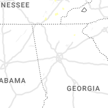
Tennessee
| Local Time | Report Details |
|---|---|
| 3:40 PM EDT | 1 tree down on bluff r in roane county TN, 35.3 miles W of Knoxville, TN |
| 4:42 PM EDT | Corrected time on previous tstm wnd dmg report from 3 ne norris. dispatch reported a few trees down near the intersection of park lane and forgety road. time estimated in anderson county TN, 20.9 miles NNW of Knoxville, TN |
| 5:00 PM EDT | Dispatch reported a few trees down near the intersection of park lane and forgety road. time estimated by rada in anderson county TN, 20.9 miles NNW of Knoxville, TN |
| 5:41 PM EDT | Dispatch received a call for a few trees down near county road 561 and 55 in mcminn county TN, 49.6 miles ENE of Chattanooga, TN |
| 6:20 PM EDT | Dispatch reported 1 tree and 1 wire down along mahan gap road. time estimated by rada in hamilton county TN, 18.5 miles ENE of Chattanooga, TN |
Connecticut
| Local Time | Report Details |
|---|---|
| 5:25 PM EDT | Trees and wires down across road near east street at kensington road. relayed by amateur radi in hartford county CT, 75.6 miles WSW of Providence, RI |
Florida
| Local Time | Report Details |
|---|---|
| 5:30 PM EDT | Thunderstorm wind gust of 59 mph measured by hand held anemomete in alachua county FL, 67.2 miles SW of Jacksonville, FL |
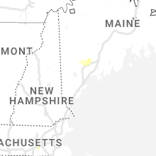
Maine
| Local Time | Report Details |
|---|---|
| 5:35 PM EDT | Social media photo of tree and powerline down blocking rt 202. time estimated by rada in androscoggin county ME, 34.8 miles N of Portland, ME |
| 6:21 PM EDT | Multiple trees and powerlines down on bolster st. time estimated by rada in androscoggin county ME, 29.1 miles N of Portland, ME |
| 6:45 PM EDT | Trees and wires down on college s in androscoggin county ME, 30.7 miles N of Portland, ME |
| 7:15 PM EDT | Power lines down across west hardscrabble rd. road close in androscoggin county ME, 27.7 miles N of Portland, ME |
Georgia
| Local Time | Report Details |
|---|---|
| 5:57 PM EDT | Quarter sized hail reported near Cleveland, GA, 63.5 miles WSW of Greenville, SC |
Kentucky
| Local Time | Report Details |
|---|---|
| 6:36 PM CDT | Half Dollar sized hail reported near Burkesville, KY, 86.2 miles SSE of Louisville, KY, quarter to half dollar sized hail. |
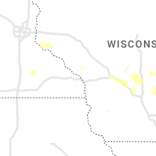
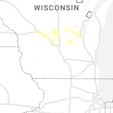
Wisconsin
| Local Time | Report Details |
|---|---|
| 7:11 PM CDT | Delayed report. tree down on a power lin in oconto county WI, 29.7 miles NNW of Green Bay, WI |
| 7:26 PM CDT | Report from mping: trees uprooted or snappe in oconto county WI, 24 miles N of Green Bay, WI |
| 7:30 PM CDT | Via social media. multiple trees down on property. estimated winds to 50 mp in oconto county WI, 24.1 miles N of Green Bay, WI |
| 4:35 AM CDT | Observed 8-inch diameter maple tree snappe in monroe county WI, 38.6 miles ENE of La Crosse, WI |
South Dakota
| Local Time | Report Details |
|---|---|
| 8:20 PM CDT | Quarter sized hail reported near Miller, SD, 61.4 miles E of Pierre, SD, estimated 60 mph winds and up to quarter sized hail. radar estimated time. |
| 8:25 PM CDT | Storm damage reported in hand county SD, 61.4 miles E of Pierre, SD |
| 8:49 PM CDT | Mesonet station 58 victor (sddot in roberts county SD, 66.1 miles S of Fargo, ND |
| 8:50 PM CDT | A shed was destroyed at the intersection of 215th and 369th ave. radar estimated tim in hand county SD, 77.1 miles E of Pierre, SD |
| 8:58 PM CDT | Mesonet station rhus2 danforth 5 e. radar estimated tim in hand county SD, 78.8 miles E of Pierre, SD |
| 9:00 PM CDT | Measured on a personal weather statio in jerauld county SD, 77.6 miles E of Pierre, SD |
| 10:07 PM CDT | Storm damage reported in davison county SD, 79.9 miles WNW of Sioux Falls, SD |
| 10:14 PM CDT | Quarter sized hail reported near Letcher, SD, 83.9 miles WNW of Sioux Falls, SD, aurora county em reported quarter size hail in storla... sd. |
| 10:19 PM CDT | Measured by personal weather statio in aurora county SD, 83.3 miles N of Oneill, NE |
| 10:30 PM CDT | Social media report of widespread large tree damage and power outages in and around mt. vernon. time estimated by rada in davison county SD, 77.6 miles W of Sioux Falls, SD |
| 10:52 PM CDT | Storm damage reported in davison county SD, 63.7 miles W of Sioux Falls, SD |
| 10:55 PM CDT | Storm damage reported in davison county SD, 63.7 miles W of Sioux Falls, SD |
| 11:04 PM CDT | Measured by storm chase in hanson county SD, 61.7 miles W of Sioux Falls, SD |
North Dakota
| Local Time | Report Details |
|---|---|
| 8:49 PM CDT | Wind gust measured 63 mph at dot site along the sd/nd borde in richland county ND, 64.7 miles S of Fargo, ND |
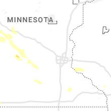
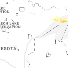
Minnesota
| Local Time | Report Details |
|---|---|
| 9:19 PM CDT | Personal weather statio in traverse county MN, 70.7 miles NW of Montevideo, MN |
| 9:20 PM CDT | One-inch tree limbs broken... per mping report. radar estimated tim in traverse county MN, 70.5 miles NNW of Montevideo, MN |
| 10:00 PM CDT | Corrects previous tstm wnd dmg report from chokio. several trees and branches 6-10 diameter tree branches are down in the city of chokio (stevens... mn) as well as powe in stevens county MN, 48.1 miles NNW of Montevideo, MN |
| 10:08 PM CDT | Awos station kmox morris a in stevens county MN, 44.4 miles NNW of Montevideo, MN |
| 10:10 PM CDT | Several trees down in town with power out. an appartment building in town had a window blow out. also several trees down across the count in stevens county MN, 44.4 miles NNW of Montevideo, MN |
| 10:20 PM CDT | A few 6-10 diameter tree branches are down in the city of chokio (stevens... mn) as well as power is currently out across tow in stevens county MN, 48.1 miles NNW of Montevideo, MN |
| 10:20 PM CDT | Tree on powerline. time estimated from rada in pope county MN, 36.3 miles N of Montevideo, MN |
| 10:25 PM CDT | Tree down across road. time estimated from rada in pope county MN, 40 miles NNE of Montevideo, MN |
| 10:57 PM CDT | Brooten fire confirming wind gusts of 50-60 mph 5 miles south of broote in stearns county MN, 44.1 miles NE of Montevideo, MN |
| 10:59 PM CDT | Shed destroyed... time estimated from radar. also report of 68 mph wind in kandiyohi county MN, 42.5 miles NE of Montevideo, MN |
| 11:01 PM CDT | Quarter sized hail reported near Glenwood, MN, 50.1 miles NNE of Montevideo, MN, report from mping: quarter (1.00 in.). |
| 11:05 PM CDT | 3-4 foot diameter trees and power poles have been snapped. pontoons have been flipped. some roof damage to building in kandiyohi county MN, 44.6 miles ENE of Montevideo, MN |
| 11:07 PM CDT | 70 to 80 mph winds reporte in stearns county MN, 49.1 miles NE of Montevideo, MN |
| 12:00 AM CDT | Wind gust of 63 mph was recorded at the ndawn in warren... mn 6s in polk county MN, 70.4 miles SW of Roseau, MN |
| 12:22 AM CDT | Corrects previous tstm wnd gst report from 4 n tabor. wind gust of 63 mph was recorded at the ndawn in warren... mn 6s in polk county MN, 70.4 miles SW of Roseau, MN |
| 12:50 AM CDT | Mesonet station mn060 e grand forks mn dot measured wind gusts ranging from 54 to 75 mp in polk county MN, 69.7 miles N of Fargo, ND |
| 1:15 AM CDT | Ping Pong Ball sized hail reported near Hoffman, MN, 58 miles N of Montevideo, MN, golf ball sized hail reported by grant county deputy... relayed by dispatch. |
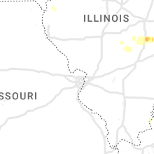
Illinois
| Local Time | Report Details |
|---|---|
| 9:42 PM CDT | Quarter sized hail reported near Lovington, IL, 20.8 miles NW of Mattoon, IL, delayed report. relayed via broadcast media. |
| 10:25 PM CDT | Tennis Ball sized hail reported near Arthur, IL, 17.6 miles NNW of Mattoon, IL, delayed report. relayed via broadcast media. |
| 10:33 PM CDT | Quarter sized hail reported near Arcola, IL, 13.5 miles NNE of Mattoon, IL, relayed via broadcast media. |
| 10:43 PM CDT | Quarter sized hail reported near Arcola, IL, 17.2 miles NNE of Mattoon, IL, relayed via broadcast media. |
| 10:47 PM CDT | Ping Pong Ball sized hail reported near Oakland, IL, 24.7 miles NE of Mattoon, IL, delayed report. via broadcast media. |
| 10:47 PM CDT | Quarter sized hail reported near Oakland, IL, 24.5 miles ENE of Mattoon, IL, report from mping: quarter (1.00 in.). |
| 11:11 PM CDT | Relayed via broadcast media. multiple power outages in the paris are in edgar county IL, 36.8 miles ENE of Mattoon, IL |
| 11:15 PM CDT | Power lines down and on fire near blackburn st on the northside of pari in edgar county IL, 37.3 miles ENE of Mattoon, IL |
Kansas
| Local Time | Report Details |
|---|---|
| 10:41 PM CDT | Mesonet station up840 9.0 w winona (upr in logan county KS, 33.1 miles SW of Colby, KS |
| 9:48 PM MDT | Asos station kgld goodlan in sherman county KS, 35.1 miles W of Colby, KS |
| 9:50 PM MDT | Asos station kgld goodlan in sherman county KS, 35.1 miles W of Colby, KS |
| 11:25 PM CDT | Mesonet station up841 1.9 w monument (upr). lasted about about 10 minute in logan county KS, 20.5 miles S of Colby, KS |
Indiana
| Local Time | Report Details |
|---|---|
| 1:55 AM EDT | Quarter sized hail reported near Martinsville, IN, 24.8 miles SW of Indianapolis, IN, quarter sized hail reported n of martinsville via social media. |
Iowa
| Local Time | Report Details |
|---|---|
| 5:03 AM CDT | Quarter sized hail reported near Fonda, IA, 22.5 miles E of Storm Lake, IA, report from mping: quarter (1.00 in.). |
Connect with Interactive Hail Maps