

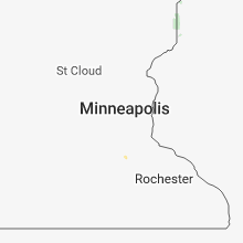
Hail Map for Monday, July 30, 2018

Number of Impacted Households on 7/30/2018
0
Impacted by 1" or Larger Hail
0
Impacted by 1.75" or Larger Hail
0
Impacted by 2.5" or Larger Hail
Square Miles of Populated Area Impacted on 7/30/2018
0
Impacted by 1" or Larger Hail
0
Impacted by 1.75" or Larger Hail
0
Impacted by 2.5" or Larger Hail


Cities Most Affected by Hail Storms of 7/30/2018
| Hail Size | Demographics of Zip Codes Affected | ||||||
|---|---|---|---|---|---|---|---|
| City | Count | Average | Largest | Pop Density | House Value | Income | Age |
| Coats, KS | 1 | 2.00 | 2.00 | 1 | $17k | $33.4k | 37.5 |
| Lake City, KS | 1 | 1.75 | 1.75 | 0 | $23k | $42.8k | 52.8 |
Hail and Wind Damage Spotted on 7/30/2018
Filter by Report Type:Hail ReportsWind Reports
Kansas
| Local Time | Report Details |
|---|---|
| 1:15 PM CDT | Reports of power poles down near south bright and 4th street. time based on rada in sumner county KS, 29.5 miles S of Wichita, KS |
| 1:16 PM CDT | Storm damage reported in sumner county KS, 26.9 miles S of Wichita, KS |
| 1:16 PM CDT | Storm damage reported in sumner county KS, 25.5 miles S of Wichita, KS |
| 2:02 PM CDT | Storm damage reported in cowley county KS, 45.2 miles SSE of Wichita, KS |
| 2:03 PM CDT | Trained spotter measured 70 mph on his davis weather statio in cowley county KS, 45.6 miles SSE of Wichita, KS |
| 7:38 PM CDT | Hen Egg sized hail reported near Coats, KS, 76.2 miles NNE of Woodward, OK, also with wind gusts estimated 50 mph. |
| 7:42 PM CDT | Golf Ball sized hail reported near Lake City, KS, 75.4 miles NNE of Woodward, OK |
Oklahoma
| Local Time | Report Details |
|---|---|
| 2:15 PM CDT | Fire department estimated wind gusts between 50-60mp in kay county OK, 57.7 miles SSE of Wichita, KS |
| 2:25 PM CDT | Local mesonet measured wind gusts up to 63mp in kay county OK, 60.4 miles SSE of Wichita, KS |
| 3:28 PM CDT | Large tree limb fell on house and damaged the porc in washington county OK, 31.1 miles N of Tulsa, OK |
| 3:37 PM CDT | Several power poles down. roof blown off of locker room at ramona high school. semo blown over on highway 75 near 2800 roa in washington county OK, 26.5 miles N of Tulsa, OK |
| 3:42 PM CDT | Storm damage reported in tulsa county OK, 6.7 miles NE of Tulsa, OK |
| 3:42 PM CDT | Storm damage reported in tulsa county OK, 10.4 miles N of Tulsa, OK |
| 3:42 PM CDT | Storm damage reported in washington county OK, 26.5 miles N of Tulsa, OK |
| 3:52 PM CDT | Tree down. via social medi in rogers county OK, 26.1 miles NE of Tulsa, OK |
| 4:00 PM CDT | Power lines down across northern portion of city of tulsa in tulsa county OK, 4.3 miles ESE of Tulsa, OK |
| 4:03 PM CDT | Storm damage reported in tulsa county OK, 6.7 miles NE of Tulsa, OK |
| 4:06 PM CDT | Power poles down near 12th and florence. time via rada in rogers county OK, 23.6 miles ENE of Tulsa, OK |
| 4:08 PM CDT | Tree blown over state highway 20 at top of keetonville hil in rogers county OK, 21.2 miles ENE of Tulsa, OK |
| 4:08 PM CDT | Power lines down in roadwa in rogers county OK, 25.8 miles NE of Tulsa, OK |
| 4:11 PM CDT | 3 inch diameter limbs broken. power poles broke in rogers county OK, 18.6 miles ENE of Tulsa, OK |
| 4:31 PM CDT | Storm damage reported in mayes county OK, 34.4 miles ENE of Tulsa, OK |
| 4:33 PM CDT | Storm damage reported in mayes county OK, 34.4 miles ENE of Tulsa, OK |
Florida
| Local Time | Report Details |
|---|---|
| 4:30 PM EDT | Trees fell across sr-50 causing a closure of the road. time estimated by rada in hernando county FL, 45.2 miles W of Orlando, FL |
Kentucky
| Local Time | Report Details |
|---|---|
| 6:46 PM EDT | 4 large trees down in trap in clark county KY, 13.1 miles NNW of Irvine, KY |
| 7:09 PM EDT | Report of a roof blown off a house on shuler r in powell county KY, 11.8 miles N of Irvine, KY |
| 7:09 PM EDT | Three trees down on highway 15 near clay cit in powell county KY, 11.3 miles NNE of Irvine, KY |
| 7:18 PM EDT | Large tree down at stanton city par in powell county KY, 11.8 miles NNE of Irvine, KY |
| 7:19 PM EDT | Tree down on caudill driv in powell county KY, 10.9 miles NE of Irvine, KY |
Arkansas
| Local Time | Report Details |
|---|---|
| 6:25 PM CDT | Tree down and estimated 60 mph. relayed via ha in crawford county AR, 5.5 miles NE of Fort Smith, AR |
| 8:02 PM CDT | Sheriff's office reports trees down along hwy 16 e in the town of clinto in van buren county AR, 58.2 miles N of Little Rock, AR |
Arizona
| Local Time | Report Details |
|---|---|
| 4:35 PM MST | Trained spotter reported that the roof has been damaged of hilcrest motel. tree limbs cover the roadways. newly planted pine trees have been uproote in mohave county AZ, 53.2 miles NNE of Lake Havasu City, AZ |
| 6:00 PM MST | 70 mph wind gust recorded by sunset point raws. time of event is estimated due to 60 minute observation interva in yavapai county AZ, 51.2 miles N of Phoenix, AZ |
| 6:15 PM MST | *** 1 inj *** cochise county sheriff's office was advised of a mobile home that had blown over with a 32 year old female inside at the time. the woman was treated for i in cochise county AZ, 15.9 miles NW of Douglas, AZ |
| 6:35 PM MST | Bartlett lak in maricopa county AZ, 36.9 miles NE of Phoenix, AZ |
| 7:13 PM MST | 74 mph wind gust at deer valley aso in maricopa county AZ, 16.7 miles N of Phoenix, AZ |
| 7:15 PM MST | Chimany dow in maricopa county AZ, 15.4 miles N of Phoenix, AZ |
| 7:15 PM MST | Large tree dow in maricopa county AZ, 5 miles N of Phoenix, AZ |
| 7:21 PM MST | Gust 63 mph at scottsdale airport aso in maricopa county AZ, 15.2 miles NE of Phoenix, AZ |
| 7:30 PM MST | Large tree limbs down on the road... blocking multiple lanes on shea blvd. i turned west onto shea blvd from n scottsdale road and continued to 32nd street. especially in maricopa county AZ, 12.4 miles NE of Phoenix, AZ |
| 7:37 PM MST | Bell road and 56st trees down. 18in tre in maricopa county AZ, 14.8 miles NNE of Phoenix, AZ |
| 7:38 PM MST | 1/4 mile visibility due to blowing dust. blowing debris and broken tree limbs (small). estimated 40kt+ wind in maricopa county AZ, 15.4 miles NE of Phoenix, AZ |
| 7:38 PM MST | 74 mph wind gust glendale aprt aso in maricopa county AZ, 14.1 miles WNW of Phoenix, AZ |
| 7:38 PM MST | Local small stream flow... low volume at this time. scottsdale rd also pinnacle pt rd. power out at 36th and greenway. 4" trees down. street signs topple in maricopa county AZ, 13.3 miles NNE of Phoenix, AZ |
| 7:39 PM MST | 36th and union hills trees dow in maricopa county AZ, 15.2 miles NNE of Phoenix, AZ |
| 7:40 PM MST | Glendale and litchfield near luke afb power ou in maricopa county AZ, 17.6 miles WNW of Phoenix, AZ |
| 7:40 PM MST | Massive tree that was uprooted and came crashing down on a home near bethany home/15th av in maricopa county AZ, 5 miles N of Phoenix, AZ |
| 7:40 PM MST | Large tree down on 12th street between missouri and bethany home r in maricopa county AZ, 5 miles N of Phoenix, AZ |
| 7:41 PM MST | 50-60 mph winds gusts and blowing dus in maricopa county AZ, 5.4 miles SW of Phoenix, AZ |
| 7:45 PM MST | Large tree down (12 inch diameter mesquite). report courtesy fcdm in maricopa county AZ, 2.8 miles WSW of Phoenix, AZ |
| 7:46 PM MST | Storm damage reported in maricopa county AZ, 12.5 miles WNW of Phoenix, AZ |
| 7:49 PM MST | Part of a roof blown off from a hom in maricopa county AZ, 13.9 miles NW of Phoenix, AZ |
| 7:50 PM MST | Large tree dow in maricopa county AZ, 13.9 miles NNE of Phoenix, AZ |
| 7:50 PM MST | American legion post lost three trees in the storm... two fell on car in maricopa county AZ, 14.4 miles NW of Phoenix, AZ |
| 7:54 PM MST | Mobile home awning dow in maricopa county AZ, 10 miles NW of Phoenix, AZ |
| 7:55 PM MST | Former nws employee. 60-70 mph wind gusts. damage to my roof and solar system on my roo in maricopa county AZ, 20.5 miles NNW of Phoenix, AZ |
| 8:00 PM MST | Trees down along greenway parkway... from 32nd street west to near cave creek. many sections of street lights out... as well as some traffic lights. these trees are ver in maricopa county AZ, 12.6 miles N of Phoenix, AZ |
| 8:04 PM MST | 3-4 inch tree limbs broken of in maricopa county AZ, 23.4 miles NW of Phoenix, AZ |
| 8:38 PM MST | Telephones out dysart & thunderbird r in maricopa county AZ, 18.9 miles NW of Phoenix, AZ |
| 8:53 PM MST | 18" tree down on 77th ave just north of mountain view partially blocking the roa in maricopa county AZ, 11.8 miles NW of Phoenix, AZ |
| 9:00 PM MST | Tree limbs down in a one block radius of approximately 6-8" in diamete in maricopa county AZ, 18.2 miles W of Phoenix, AZ |
| 9:06 PM MST | Tree down on roa in maricopa county AZ, 18.7 miles W of Phoenix, AZ |
New Mexico
| Local Time | Report Details |
|---|---|
| 6:20 PM MDT | Wet microburst win in sierra county NM, 79.3 miles N of El Paso, TX |
| 7:40 PM MDT | Quarter sized hail reported near Rio Rancho, NM, 12.8 miles N of Albuquerque, NM |
| 8:20 PM MDT | Quarter sized hail reported near Albuquerque, NM, 3.5 miles ENE of Albuquerque, NM, indian school and san mateo. |
| 8:20 PM MDT | Half Dollar sized hail reported near Albuquerque, NM, 2.2 miles E of Albuquerque, NM, constitution and girard. |
| 8:29 PM MDT | Half Dollar sized hail reported near Albuquerque, NM, 3 miles ENE of Albuquerque, NM, carlisle and lomas |
| 8:32 PM MDT | Quarter sized hail reported near Albuquerque, NM, 3.2 miles ESE of Albuquerque, NM, vassar and santa clara se |
| 8:45 PM MDT | Quarter sized hail reported near Albuquerque, NM, 3.4 miles E of Albuquerque, NM, lomas and carlisle |
Virginia
| Local Time | Report Details |
|---|---|
| 9:40 PM EDT | Tree down on a power line on egg farm road. time estimate in patrick county VA, 38.5 miles SSW of Roanoke, VA |
Connect with Interactive Hail Maps