

Hail Map for Tuesday, July 31, 2018

Number of Impacted Households on 7/31/2018
0
Impacted by 1" or Larger Hail
0
Impacted by 1.75" or Larger Hail
0
Impacted by 2.5" or Larger Hail
Square Miles of Populated Area Impacted on 7/31/2018
0
Impacted by 1" or Larger Hail
0
Impacted by 1.75" or Larger Hail
0
Impacted by 2.5" or Larger Hail


Cities Most Affected by Hail Storms of 7/31/2018
| Hail Size | Demographics of Zip Codes Affected | ||||||
|---|---|---|---|---|---|---|---|
| City | Count | Average | Largest | Pop Density | House Value | Income | Age |
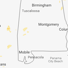
| Newton, MS | 1 | 2.50 | 2.50 | 52 | $55k | $26.8k | 39.7 |
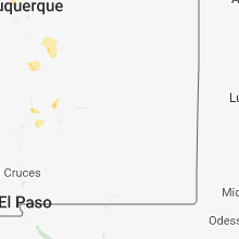
| Youngsville, NM | 1 | 2.00 | 2.00 | 0 | $55k | $18.3k | 46.3 |
| Jemez Pueblo, NM | 1 | 1.75 | 1.75 | 6 | $61k | $28.8k | 34.8 |
| Lake Park, MN | 1 | 1.75 | 1.75 | 21 | $95k | $40.2k | 47.0 |
| Jemez Springs, NM | 1 | 1.75 | 1.75 | 4 | $181k | $61.3k | 52.6 |
Hail and Wind Damage Spotted on 7/31/2018
Filter by Report Type:Hail ReportsWind Reports
States Impacted
Louisiana, Texas, Mississippi, West Virginia, Kentucky, Pennsylvania, Alabama, North Carolina, Missouri, Georgia, New Mexico, Minnesota, South Dakota, Ohio, MichiganLouisiana
| Local Time | Report Details |
|---|---|
| 10:18 AM CDT | Tree down one half mile east of hwy 34 on aunt maries roa in winn county LA, 62.9 miles SW of Bastrop, LA |
| 9:10 PM CDT | Tree down in ero in jackson county LA, 39.8 miles SW of Bastrop, LA |
| 10:15 PM CDT | Tree down at the intersection of la hwys 34 and 12 in winn county LA, 61.8 miles SW of Bastrop, LA |
| 10:18 PM CDT | Corrected time. tree down one half mile east of hwy 34 on aunt maries roa in winn county LA, 62.9 miles SW of Bastrop, LA |
| 10:20 PM CDT | Tree down on hwy 126 just east of dodso in winn county LA, 64.5 miles SW of Bastrop, LA |
Texas
| Local Time | Report Details |
|---|---|
| 12:39 PM CDT | Photo of large tree limb down on home in houston country club. time estimated by radar signatur in harris county TX, 3.7 miles SE of Houston, TX |
| 4:41 PM CDT | Storm damage reported in culberson county TX, 99.1 miles E of El Paso, TX |
Mississippi
| Local Time | Report Details |
|---|---|
| 12:42 PM CDT | A tree was blown down across hattie wallace road. other limbs and branches were down as well in the are in scott county MS, 32.6 miles ENE of Jackson, MS |
| 1:35 PM CDT | Tree downed at sims rd and old river rd and dime size hail reporte in forrest county MS, 79.6 miles WNW of Mobile, AL |
| 1:40 PM CDT | Trees down on wingate road west of highway 1 in perry county MS, 67.2 miles NW of Mobile, AL |
| 1:41 PM CDT | Trees were blown down... windows blown out of greenhouses... roof was blown off of a shop... roof blown off of a carport and a tree fell onto a house along george mason in newton county MS, 59.1 miles E of Jackson, MS |
| 1:42 PM CDT | Tennis Ball sized hail reported near Newton, MS, 59.1 miles E of Jackson, MS, tennis ball hail lasted for approximately 1 minute. |
| 1:42 PM CDT | Trees were blown down along highway 8 in newton county MS, 59.8 miles E of Jackson, MS |
| 1:44 PM CDT | A few trees blown over across from james h easom field. report relayed by the airport manage in newton county MS, 60.9 miles E of Jackson, MS |
| 1:53 PM CDT | Several trees down on old river rd near new august in perry county MS, 73.1 miles WNW of Mobile, AL |
| 1:55 PM CDT | Trees down on old augusta road near clay hill roa in perry county MS, 70.2 miles NW of Mobile, AL |
| 1:57 PM CDT | Trees down on will best road off of camp eight roa in perry county MS, 69.4 miles NW of Mobile, AL |
| 2:15 PM CDT | Trees downed along ms highway 15 in jones count in jones county MS, 77.5 miles NW of Mobile, AL |
| 2:24 PM CDT | Corrects previous erroneous flash flood report from 10 se laurel. trees downed on township r in jones county MS, 84 miles SE of Jackson, MS |
| 2:28 PM CDT | Corrects previous erroneous flash flood report from 6 ese laurel. trees downed across lower myrick r in jones county MS, 80 miles SE of Jackson, MS |
| 2:30 PM CDT | A power line was downed on jefferson st near the hospita in jones county MS, 74.1 miles SE of Jackson, MS |
| 2:30 PM CDT | A tree was blown onto a house along jessie malone r in jones county MS, 81.5 miles ESE of Jackson, MS |
West Virginia
| Local Time | Report Details |
|---|---|
| 1:42 PM EDT | Multiple trees down around the town of lavalette in wayne county WV, 43.6 miles W of Charleston, WV |
| 2:12 PM EDT | Received reports from 911 call center of many power lines and trees down in the area. one report of a tree falling down on a house. 911 call center also mentioned a rad in cabell county WV, 27.2 miles WNW of Charleston, WV |
| 2:20 PM EDT | Tree down across lower coach road. sections of the road are blocked by limb in putnam county WV, 22.3 miles WNW of Charleston, WV |
| 2:25 PM EDT | Numerous reports of trees and power lines down throughout hurrican in putnam county WV, 21.6 miles WNW of Charleston, WV |
| 3:50 PM EDT | Numerous trees reported down throughout the mt zion area in calhoun county WV, 44.3 miles NE of Charleston, WV |
| 4:00 PM EDT | Tree down across servia/elmira road in braxton county WV, 49.6 miles WSW of Elkins, WV |
| 4:10 PM EDT | 911 metro received a call of a tree down at the intersection of newquay drive and walker drive that was blocking one lane of traffi in kanawha county WV, 7.6 miles N of Charleston, WV |
| 4:25 PM EDT | Tree reported down across tunnel fork road in braxton county WV, 49.6 miles WSW of Elkins, WV |
Kentucky
| Local Time | Report Details |
|---|---|
| 2:26 PM EDT | Tree down on combs branch road east of hindma in knott county KY, 61.5 miles ESE of Irvine, KY |
| 3:20 PM EDT | Tree down in meta on highway 194. report from state police via publi in pike county KY, 68.5 miles N of Bristol, TN |
Pennsylvania
| Local Time | Report Details |
|---|---|
| 2:47 PM EDT | Several trees down and blocking road around ridge st. and mcneely rd in jefferson tw in greene county PA, 37.5 miles S of Pittsburgh, PA |
Alabama
| Local Time | Report Details |
|---|---|
| 1:50 PM CDT | Minor damage to lakeside building supply & damage to metal roofing at poly-fabricators... inc. also... several trees snapped in adjacent fields behind the businesses. t in barbour county AL, 58.6 miles SSE of Auburn, AL |
| 1:55 PM CDT | Tree down partially blocking alabama highway 9 near salem church in cedar bluff. estimated 40-50 mph winds. time estimated by rada in cherokee county AL, 55.7 miles S of Chattanooga, TN |
| 4:10 PM CDT | Tree down with one lane blocked. time estimated from radar. sub-severe winds probabl in cherokee county AL, 64.8 miles SSW of Chattanooga, TN |
North Carolina
| Local Time | Report Details |
|---|---|
| 3:22 PM EDT | Several trees down at hinshaw road and old 421. time from rada in yadkin county NC, 64.2 miles N of Charlotte, NC |
Missouri
| Local Time | Report Details |
|---|---|
| 3:15 PM CDT | Quarter sized hail reported near Bloomfield, MO, 30.7 miles SW of Cape Girardeau, MO, estimated quarter sized hail covered the ground in aquilla. |
Georgia
| Local Time | Report Details |
|---|---|
| 4:25 PM EDT | A tree fell into the front of a home in trio in chattooga county GA, 34.9 miles S of Chattanooga, TN |
New Mexico
| Local Time | Report Details |
|---|---|
| 4:44 PM MDT | Golf Ball sized hail reported near Jemez Pueblo, NM, 40.7 miles N of Albuquerque, NM |
| 4:45 PM MDT | Hen Egg sized hail reported near Youngsville, NM, 57.1 miles WSW of Taos, NM |
| 6:50 PM MDT | Quarter sized hail reported near Jemez Springs, NM, 54.2 miles N of Albuquerque, NM |
| 7:20 PM MDT | Quarter sized hail reported near Las Vegas, NM, 53.7 miles S of Taos, NM |
| 7:27 PM MDT | Golf Ball sized hail reported near Jemez Springs, NM, 43.3 miles N of Albuquerque, NM |
| 8:20 PM MDT | Quarter sized hail reported near Rociada, NM, 41 miles SSE of Taos, NM |
| 8:32 PM MDT | Quarter sized hail reported near Rio Rancho, NM, 15.9 miles NNW of Albuquerque, NM, king and unser |
| 8:35 PM MDT | Quarter sized hail reported near Rio Rancho, NM, 13.3 miles NNW of Albuquerque, NM, idalia and unser |
Minnesota
| Local Time | Report Details |
|---|---|
| 6:41 PM CDT | Quarter sized hail reported near Shevlin, MN, 21.3 miles NNW of Bemidji, MN, from social media with time estimated by radar |
| 7:07 PM CDT | Quarter sized hail reported near Leonard, MN, 22 miles NW of Bemidji, MN, hail from video posted to broadcast media social media account with time estimated via radar |
| 10:53 PM CDT | Golf Ball sized hail reported near Lake Park, MN, 35 miles ESE of Fargo, ND, law enforcement reported quarter to golf ball hail. |
South Dakota
| Local Time | Report Details |
|---|---|
| 7:00 PM CDT | Estimated 60 mph wind in mcpherson county SD, 18.1 miles NW of Aberdeen, SD |
| 7:15 PM CDT | Estimated 50-60 mph wind in mcpherson county SD, 18.1 miles NW of Aberdeen, SD |
Ohio
| Local Time | Report Details |
|---|---|
| 10:15 PM EDT | Reports of damage and cars flipped near brown road in the oregon area relayed from law enforcement dispatch. possible tornado damag in lucas county OH, 91 miles W of Cleveland, OH |
| 10:50 PM EDT | Trees blown down and possible damage relayed from law enforcement dispatch. time is estimated. possible tornado damag in lucas county OH, 89.7 miles S of Flint, MI |
Michigan
| Local Time | Report Details |
|---|---|
| 12:45 AM EDT | Estimated 60 mph winds and heavy rai in wayne county MI, 59.1 miles SSE of Flint, MI |
| 12:46 AM EDT | Reports of damage to a comerica ban in wayne county MI, 57.9 miles SSE of Flint, MI |
Connect with Interactive Hail Maps