

Hail Map for Sunday, July 29, 2018

Number of Impacted Households on 7/29/2018
0
Impacted by 1" or Larger Hail
0
Impacted by 1.75" or Larger Hail
0
Impacted by 2.5" or Larger Hail
Square Miles of Populated Area Impacted on 7/29/2018
0
Impacted by 1" or Larger Hail
0
Impacted by 1.75" or Larger Hail
0
Impacted by 2.5" or Larger Hail


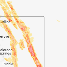


Cities Most Affected by Hail Storms of 7/29/2018
| Hail Size | Demographics of Zip Codes Affected | ||||||
|---|---|---|---|---|---|---|---|
| City | Count | Average | Largest | Pop Density | House Value | Income | Age |
| Flagler, CO | 7 | 2.32 | 2.75 | 1 | $74k | $30.4k | 46.7 |
| Cheyenne, WY | 8 | 1.81 | 2.00 | 35 | $125k | $49.7k | 40.5 |
| Kit Carson, CO | 3 | 2.75 | 2.75 | 0 | $45k | $28.1k | 42.2 |
| Strasburg, CO | 3 | 2.08 | 2.50 | 21 | $179k | $52.4k | 38.7 |
| Granada, CO | 2 | 2.50 | 3.00 | 0 | $59k | $27.4k | 34.0 |
| Holly, CO | 2 | 2.25 | 2.75 | 1 | $42k | $27.2k | 43.2 |
| Manter, KS | 2 | 2.13 | 2.50 | 0 | $75k | $43.8k | 43.6 |
| Grover, CO | 2 | 2.13 | 2.50 | 0 | $74k | $22.7k | 47.9 |
| Bennett, CO | 2 | 1.75 | 1.75 | 16 | $141k | $55.3k | 40.3 |
| Chugwater, WY | 2 | 1.75 | 1.75 | 0 | $73k | $37.9k | 47.8 |
| Livermore, CO | 1 | 2.50 | 2.50 | 5 | $190k | $59.7k | 53.6 |
| Evans, CO | 1 | 2.00 | 2.00 | 2881 | $117k | $35.7k | 27.9 |
| Genoa, CO | 1 | 2.00 | 2.00 | 1 | $38k | $28.8k | 43.5 |
| Seibert, CO | 1 | 2.00 | 2.00 | 0 | $43k | $25.8k | 49.4 |
| Kiowa, CO | 1 | 2.00 | 2.00 | 7 | $183k | $49.4k | 44.2 |
| Fowler, CO | 1 | 2.00 | 2.00 | 3 | $70k | $31.0k | 44.4 |
| Westerville, NE | 1 | 2.00 | 2.00 | 3 | $19k | $36.6k | 30.3 |
| Kyle, SD | 1 | 2.00 | 2.00 | 0 | $27k | $23.9k | 24.1 |
| Calhan, CO | 1 | 2.00 | 2.00 | 17 | $121k | $42.2k | 39.6 |
| Ramah, CO | 1 | 2.00 | 2.00 | 3 | $91k | $39.0k | 44.6 |
| Akron, CO | 1 | 1.75 | 1.75 | 2 | $73k | $31.6k | 44.7 |
| Fort Collins, CO | 1 | 1.75 | 1.75 | 2017 | $191k | $53.4k | 35.5 |
| Spearfish, SD | 1 | 1.75 | 1.75 | 62 | $98k | $30.2k | 38.6 |
| Albin, WY | 1 | 1.75 | 1.75 | 1 | $46k | $38.8k | 35.3 |
| Greeley, CO | 1 | 1.75 | 1.75 | 1454 | $147k | $49.0k | 36.2 |
| Laramie, WY | 1 | 1.75 | 1.75 | 16 | $119k | $32.2k | 27.6 |
| Limon, CO | 1 | 1.75 | 1.75 | 2 | $88k | $35.1k | 38.2 |
Hail and Wind Damage Spotted on 7/29/2018
Filter by Report Type:Hail ReportsWind Reports
States Impacted
Arkansas, South Dakota, Louisiana, Wyoming, Colorado, North Dakota, Arizona, Nebraska, Texas, West Virginia, Kansas, OklahomaArkansas
| Local Time | Report Details |
|---|---|
| 1:15 PM CDT | Sheriff department reports large tree down across us hwy 82 near the intersection of arkansas hwy 9 in columbia county AR, 50.2 miles SE of Nashville, AR |
| 1:17 PM CDT | Trees and power lines down along highway 71 in and around fouk in miller county AR, 48.2 miles S of Nashville, AR |
| 1:37 PM CDT | Sheriff department reports large tree down across us hwy 371 near the intersection of columbia road in columbia county AR, 50.5 miles NNE of Shreveport, LA |
South Dakota
| Local Time | Report Details |
|---|---|
| 12:53 PM MDT | Storm damage reported in harding county SD, 106 miles N of Rapid City, SD |
| 1:30 PM MDT | Quarter sized hail reported near Hot Springs, SD, 38.2 miles SSW of Rapid City, SD |
| 2:10 PM MDT | Half Dollar sized hail reported near Kyle, SD, 70.3 miles SE of Rapid City, SD |
| 2:10 PM MDT | Hen Egg sized hail reported near Kyle, SD, 69.3 miles SE of Rapid City, SD |
| 2:14 PM MDT | Out buildings and homes damaged in oglala lakota county SD, 71 miles SE of Rapid City, SD |
| 2:40 PM MDT | Quarter sized hail reported near Oelrichs, SD, 69 miles S of Rapid City, SD |
| 2:40 PM MDT | Golf Ball sized hail reported near Spearfish, SD, 44.9 miles NW of Rapid City, SD |
| 2:40 PM MDT | Storm damage reported in fall river county SD, 69 miles S of Rapid City, SD |
| 2:55 PM MDT | Storm damage reported in lawrence county SD, 36.5 miles NW of Rapid City, SD |
| 2:55 PM MDT | Quarter sized hail reported near Spearfish, SD, 36.5 miles NW of Rapid City, SD |
| 3:10 PM MDT | Storm damage reported in lawrence county SD, 27 miles WNW of Rapid City, SD |
| 3:15 PM MDT | Quarter sized hail reported near Deadwood, SD, 27 miles WNW of Rapid City, SD |
| 3:16 PM MDT | Storm damage reported in lawrence county SD, 27 miles WNW of Rapid City, SD |
| 3:28 PM MDT | Quarter sized hail reported near Deadwood, SD, 22.4 miles WNW of Rapid City, SD |
| 6:00 PM MDT | Quarter sized hail reported near Edgemont, SD, 60.6 miles SW of Rapid City, SD |
| 6:05 PM MDT | Quarter sized hail reported near Edgemont, SD, 60.6 miles SW of Rapid City, SD |
Louisiana
| Local Time | Report Details |
|---|---|
| 2:18 PM CDT | Trees and limbs down in the benton are in bossier county LA, 12.8 miles N of Shreveport, LA |
| 2:21 PM CDT | Large tree down in home in claiborne county LA, 44.9 miles ENE of Shreveport, LA |
| 2:25 PM CDT | Sheriff department reports trees and power lines down near intersection of castle dale and henderson gin roa in caddo county LA, 12 miles NW of Shreveport, LA |
| 2:27 PM CDT | Nws employee estimates 60mph wind gusts. small limbs are down in his vicinit in caddo county LA, 6.2 miles SSE of Shreveport, LA |
| 2:30 PM CDT | Tree and power lines down on albany avenue between anniston avenue and east kings highwa in caddo county LA, 3.5 miles SSE of Shreveport, LA |
| 2:30 PM CDT | Sheriff department reports trees and power lines down near cross lake on lake forest hills driv in caddo county LA, 3.2 miles WSW of Shreveport, LA |
| 2:30 PM CDT | A large tree was blown down across dalzell street near fairfield avenue in shrevepor in caddo county LA, 1.7 miles S of Shreveport, LA |
| 2:30 PM CDT | Severe thunderstorm winds created high waves which capsized a boat on the bossier parish side of the red river near red river south marina. several boaters were thrown in bossier county LA, 10.8 miles SE of Shreveport, LA |
| 2:35 PM CDT | Trees and limbs down in... and around... haughton. swepco is reporting power outages in the city as wel in bossier county LA, 14.5 miles E of Shreveport, LA |
| 2:35 PM CDT | A utility pole was snapped with power lines down across south lakeshore driv in caddo county LA, 8.4 miles W of Shreveport, LA |
| 2:43 PM CDT | Trained weather spotter reported limbs and trees down along greenway place. includes that that a large limb or tree fell on a parked truc in caddo county LA, 3.2 miles SSE of Shreveport, LA |
| 3:10 PM CDT | Reports of two trees down in stonewal in de soto county LA, 17.4 miles SSW of Shreveport, LA |
| 3:15 PM CDT | Sheriff department reports trees and power lines down on keithville-springridge roa in caddo county LA, 15.2 miles SSW of Shreveport, LA |
| 3:45 PM CDT | Scattered damage across rocky branch and the se part of the paris in union county LA, 17.9 miles WSW of Bastrop, LA |
| 4:00 PM CDT | A large limb took down a power line... blocking a road in tow in winn county LA, 64.9 miles SW of Bastrop, LA |
| 4:13 PM CDT | Trees and power lines down in the cit in natchitoches county LA, 64.2 miles SE of Shreveport, LA |
| 4:36 PM CDT | Trees down throughout the city of cloutiervill in natchitoches county LA, 82.3 miles SE of Shreveport, LA |
| 4:40 PM CDT | Power lines down along hw 133 near bethany baptist churc in caldwell county LA, 43 miles S of Bastrop, LA |
| 4:55 PM CDT | Tree fell across hw 500 just west of tow in grant county LA, 76.1 miles SSW of Bastrop, LA |
| 5:05 PM CDT | Large limbs knocked over power lines in various locations throughout the cit in grant county LA, 91.7 miles SE of Shreveport, LA |
| 5:15 PM CDT | Broadcast media reported tree down on a car in the eunice are in st. landry county LA, 30.4 miles NW of Lafayette, LA |
| 7:00 PM CDT | Tree limbs down along with small hail near ragle in beauregard county LA, 41.7 miles NE of Beaumont, TX |
Wyoming
| Local Time | Report Details |
|---|---|
| 1:23 PM MDT | Golf Ball sized hail reported near Chugwater, WY, 48.4 miles W of Scottsbluff, NE |
| 1:25 PM MDT | Quarter sized hail reported near Chugwater, WY, 50.5 miles NE of Laramie, WY, most were 3/4 inch. |
| 1:33 PM MDT | Quarter sized hail reported near Wheatland, WY, 53.7 miles NNE of Laramie, WY |
| 1:50 PM MDT | Quarter sized hail reported near Albin, WY, 38 miles SW of Scottsbluff, NE, mile post 50 on hwy 85 |
| 1:55 PM MDT | Hen Egg sized hail reported near Cheyenne, WY, 43.4 miles SW of Scottsbluff, NE, reports of several broken car windows and damaged vehicles on highway 85 mile marker 51. |
| 2:05 PM MDT | Golf Ball sized hail reported near Albin, WY, 38 miles SW of Scottsbluff, NE, mile marker 6-7 on hwy 16 |
| 2:06 PM MDT | Quarter sized hail reported near Chugwater, WY, 45 miles NE of Laramie, WY |
| 2:15 PM MDT | Golf Ball sized hail reported near Chugwater, WY, 50.5 miles NE of Laramie, WY, hail nickle to golfball east of chugwater. |
| 2:20 PM MDT | Ping Pong Ball sized hail reported near Chugwater, WY, 45 miles NE of Laramie, WY |
| 2:40 PM MDT | Half Dollar sized hail reported near Cheyenne, WY, 41.7 miles E of Laramie, WY |
| 2:42 PM MDT | Golf Ball sized hail reported near Cheyenne, WY, 45 miles E of Laramie, WY, late report via social media. near highway 85 north of cheyenne. |
| 2:45 PM MDT | Quarter sized hail reported near Cheyenne, WY, 39.4 miles ESE of Laramie, WY |
| 2:45 PM MDT | Golf Ball sized hail reported near Cheyenne, WY, 41.7 miles E of Laramie, WY |
| 2:59 PM MDT | Hen Egg sized hail reported near Cheyenne, WY, 44.7 miles ESE of Laramie, WY |
| 3:00 PM MDT | Ping Pong Ball sized hail reported near Cheyenne, WY, 45.9 miles E of Laramie, WY |
| 3:00 PM MDT | Golf Ball sized hail reported near Cheyenne, WY, 47.7 miles ESE of Laramie, WY, dell range and green mountain.broken windows and sky lights as well as tree damage. this occurred in the saddle ridge and dakota crossing neighborhoods. this report cam |
| 3:04 PM MDT | Half Dollar sized hail reported near Cheyenne, WY, 46.7 miles ESE of Laramie, WY |
| 3:06 PM MDT | Ping Pong Ball sized hail reported near Cheyenne, WY, 46.7 miles ESE of Laramie, WY |
| 3:07 PM MDT | Golf Ball sized hail reported near Cheyenne, WY, 44.5 miles ESE of Laramie, WY |
| 3:14 PM MDT | Golf Ball sized hail reported near Cheyenne, WY, 45.1 miles ESE of Laramie, WY |
| 4:20 PM MDT | Golf Ball sized hail reported near Cheyenne, WY, 47.7 miles ESE of Laramie, WY, dell range and green mountain.broken windows and sky lights as well as tree damage. this occurred in the saddle ridge and dakota crossing neighborhoods. this report cam |
| 5:52 PM MDT | Golf Ball sized hail reported near Laramie, WY, 11.8 miles S of Laramie, WY |
Colorado
| Local Time | Report Details |
|---|---|
| 3:27 PM MDT | Storm damage reported in weld county CO, 70 miles SSW of Scottsbluff, NE |
| 3:29 PM MDT | Golf Ball sized hail reported near Grover, CO, 72.5 miles SSW of Scottsbluff, NE |
| 3:47 PM MDT | Tennis Ball sized hail reported near Grover, CO, 79.1 miles SSW of Scottsbluff, NE |
| 4:08 PM MDT | Half Dollar sized hail reported near Colorado Springs, CO, 29.8 miles NNW of Pueblo, CO, fort carson. |
| 5:07 PM MDT | Storm damage reported in washington county CO, 25.9 miles W of Yuma, CO |
| 5:24 PM MDT | Corrects previous tstm wnd gst report from 7 e akron. semi's blown over east of akron along highway 3 in washington county CO, 19.1 miles W of Yuma, CO |
| 5:32 PM MDT | Hen Egg sized hail reported near Genoa, CO, 58.4 miles SW of Yuma, CO, hail covering the ground. |
| 5:40 PM MDT | Golf Ball sized hail reported near Akron, CO, 28.8 miles WSW of Yuma, CO, reported minor flooding with 4 inches of standing water in her yard. |
| 6:00 PM MDT | Tennis Ball sized hail reported near Livermore, CO, 27.9 miles SSE of Laramie, WY |
| 6:02 PM MDT | Gusts are continuing for atleast 5 minute in kit carson county CO, 42.9 miles SSW of Yuma, CO |
| 6:05 PM MDT | Baseball sized hail reported near Flagler, CO, 36.8 miles SSW of Yuma, CO |
| 6:10 PM MDT | Golf Ball sized hail reported near Flagler, CO, 58.2 miles SSW of Yuma, CO, hail was atleast golf ball... probably bigger. |
| 6:10 PM MDT | Baseball sized hail reported near Flagler, CO, 59.4 miles SSW of Yuma, CO, hail slightly under baseball size falling. hail is damaging buildings and trees. |
| 6:11 PM MDT | Golf Ball sized hail reported near Flagler, CO, 54.2 miles SSW of Yuma, CO |
| 6:12 PM MDT | Peak so far for this sit in kit carson county CO, 42.9 miles SSW of Yuma, CO |
| 6:12 PM MDT | Baseball sized hail reported near Flagler, CO, 60.1 miles SSW of Yuma, CO |
| 6:13 PM MDT | Tennis Ball sized hail reported near Flagler, CO, 59.4 miles SSW of Yuma, CO |
| 6:15 PM MDT | Hen Egg sized hail reported near Seibert, CO, 57 miles S of Yuma, CO, hail was atleast 2 inch in diameter. |
| 6:15 PM MDT | Significant damage to homes and vehicles was done by not only by the wind but hail. specifics are not available at this tim in kit carson county CO, 57 miles S of Yuma, CO |
| 6:17 PM MDT | Ping Pong Ball sized hail reported near Flagler, CO, 60.1 miles SSW of Yuma, CO, quarter to ping pong ball-sized hail / tree branches down / vehicle windows shattered from hail along i-70. |
| 6:22 PM MDT | Quarter sized hail reported near Livermore, CO, 29 miles SE of Laramie, WY |
| 6:26 PM MDT | Gusts for this site have decreased from the earlier peak of 83 mp in kit carson county CO, 42.9 miles SSW of Yuma, CO |
| 6:27 PM MDT | Gusts continue to declin in kit carson county CO, 42.9 miles SSW of Yuma, CO |
| 6:33 PM MDT | Hen Egg sized hail reported near Flagler, CO, 60.1 miles SSW of Yuma, CO, 2" hail lasted approx. 5 min / 40-70 mph gusts. |
| 6:49 PM MDT | Quarter sized hail reported near Livermore, CO, 40 miles SSE of Laramie, WY |
| 6:51 PM MDT | Quarter sized hail reported near Wellington, CO, 52.5 miles SE of Laramie, WY |
| 6:52 PM MDT | Golf Ball sized hail reported near Limon, CO, 68.7 miles SW of Yuma, CO |
| 6:55 PM MDT | Ping Pong Ball sized hail reported near Kit Carson, CO, 85.4 miles S of Yuma, CO, atleast one vehicle window was broken by the hail. |
| 6:55 PM MDT | Storm damage reported in lincoln county CO, 76.8 miles ESE of Denver, CO |
| 6:56 PM MDT | Quarter sized hail reported near Wellington, CO, 51.1 miles SE of Laramie, WY |
| 7:01 PM MDT | Baseball sized hail reported near Kit Carson, CO, 93.8 miles S of Yuma, CO |
| 7:06 PM MDT | Storm damage reported in lincoln county CO, 76.8 miles ESE of Denver, CO |
| 7:07 PM MDT | Quarter sized hail reported near Fort Collins, CO, 54.6 miles N of Denver, CO |
| 7:08 PM MDT | Quarter sized hail reported near Fort Collins, CO, 56.7 miles N of Denver, CO |
| 7:14 PM MDT | Quarter sized hail reported near Fort Collins, CO, 56.1 miles SSE of Laramie, WY |
| 7:15 PM MDT | Golf Ball sized hail reported near Fort Collins, CO, 56.6 miles N of Denver, CO |
| 7:15 PM MDT | Half Dollar sized hail reported near Greeley, CO, 47.3 miles NNE of Denver, CO |
| 7:18 PM MDT | Ping Pong Ball sized hail reported near Greeley, CO, 49.4 miles NNE of Denver, CO |
| 7:21 PM MDT | Quarter sized hail reported near Greeley, CO, 47.3 miles NNE of Denver, CO |
| 7:22 PM MDT | Golf Ball sized hail reported near Greeley, CO, 49.2 miles NNE of Denver, CO |
| 7:25 PM MDT | Quarter sized hail reported near Sheridan Lake, CO, 93.5 miles SW of Colby, KS |
| 7:26 PM MDT | Hen Egg sized hail reported near Evans, CO, 46.8 miles NNE of Denver, CO |
| 7:29 PM MDT | Baseball sized hail reported near Kit Carson, CO, 80.7 miles S of Yuma, CO |
| 7:37 PM MDT | Half Dollar sized hail reported near La Salle, CO, 41.5 miles NNE of Denver, CO |
| 7:39 PM MDT | Ping Pong Ball sized hail reported near Sheridan Lake, CO, 86.5 miles WNW of Garden City, KS |
| 7:40 PM MDT | Quarter sized hail reported near Agate, CO, 46.2 miles ESE of Denver, CO |
| 7:53 PM MDT | Quarter sized hail reported near La Salle, CO, 45.2 miles NNE of Denver, CO |
| 8:04 PM MDT | Ping Pong Ball sized hail reported near Holly, CO, 79.6 miles W of Garden City, KS |
| 8:04 PM MDT | Baseball sized hail reported near Holly, CO, 79.2 miles W of Garden City, KS, several windows and windshields broken due to hail and wind. |
| 8:08 PM MDT | Hen Egg sized hail reported near Granada, CO, 78.7 miles W of Garden City, KS, two windows broken due to hail and wind. widespread tree damage. |
| 8:08 PM MDT | Tea Cup sized hail reported near Granada, CO, 78.7 miles W of Garden City, KS, picture on twitter. time estimated from radar. |
| 8:08 PM MDT | Half Dollar sized hail reported near Granada, CO, 78.7 miles W of Garden City, KS |
| 8:10 PM MDT | Us 50 closed near granada... co. fallen tree blocking all lanes. time estimated from rada in prowers county CO, 78.7 miles W of Garden City, KS |
| 8:10 PM MDT | Half Dollar sized hail reported near Bennett, CO, 30.7 miles E of Denver, CO |
| 8:11 PM MDT | Golf Ball sized hail reported near Bennett, CO, 30.5 miles E of Denver, CO |
| 8:12 PM MDT | Golf Ball sized hail reported near Bennett, CO, 31.5 miles E of Denver, CO |
| 8:15 PM MDT | Tennis Ball sized hail reported near Strasburg, CO, 35.3 miles E of Denver, CO |
| 8:16 PM MDT | Ping Pong Ball sized hail reported near Strasburg, CO, 37.4 miles E of Denver, CO |
| 8:18 PM MDT | Golf Ball sized hail reported near Strasburg, CO, 35.8 miles E of Denver, CO |
| 8:19 PM MDT | Hen Egg sized hail reported near Strasburg, CO, 35.3 miles E of Denver, CO |
| 8:21 PM MDT | Baseball sized hail reported near Kit Carson, CO, 93.8 miles S of Yuma, CO, destroyed car windshield / reported via social media. |
| 8:25 PM MDT | Golf Ball sized hail reported near Holly, CO, 68.3 miles W of Garden City, KS |
| 8:45 PM MDT | Ping Pong Ball sized hail reported near Calhan, CO, 52.4 miles SE of Denver, CO |
| 8:45 PM MDT | Hen Egg sized hail reported near Kiowa, CO, 37.4 miles ESE of Denver, CO |
| 9:05 PM MDT | Time approximate. several sheds destroye in el paso county CO, 58 miles NNE of Pueblo, CO |
| 9:05 PM MDT | Hen Egg sized hail reported near Calhan, CO, 58 miles NNE of Pueblo, CO, time approximate. broken windows in home. |
| 9:09 PM MDT | Hen Egg sized hail reported near Ramah, CO, 62.1 miles SE of Denver, CO |
| 9:15 PM MDT | Quarter sized hail reported near Calhan, CO, 51.9 miles NNE of Pueblo, CO, reported at judge orr and yoder rd. |
| 10:33 PM MDT | Hen Egg sized hail reported near Fowler, CO, 33.5 miles ESE of Pueblo, CO |
| 10:35 PM MDT | Half Dollar sized hail reported near Fowler, CO, 33.5 miles ESE of Pueblo, CO |
North Dakota
| Local Time | Report Details |
|---|---|
| 4:36 PM CDT | Quarter sized hail reported near Denhoff, ND, 62.9 miles SE of Minot, ND, time estimated from radar. hail lasted about 20 minutes. started out as pea size and became quarter size. |
Arizona
| Local Time | Report Details |
|---|---|
| 5:15 PM MST | Delayed report...power is out in miami. time estimated from radar and nearby report of power lines snappe in gila county AZ, 70.4 miles E of Phoenix, AZ |
| 5:20 PM MST | Public report via twitter showing power lines snapped between miami and claypoo in gila county AZ, 70.9 miles E of Phoenix, AZ |
Nebraska
| Local Time | Report Details |
|---|---|
| 7:45 PM CDT | Hen Egg sized hail reported near Westerville, NE, 62.1 miles WNW of Grand Island, NE, delayed report via social media with picture |
| 7:59 PM CDT | Quarter sized hail reported near Ansley, NE, 56.6 miles WNW of Grand Island, NE |
| 8:32 PM CDT | Quarter sized hail reported near Callaway, NE, 41.6 miles E of North Platte, NE |
| 9:25 PM CDT | Wind gusts estimated to be between 60 and 65 mph. tree limbs of 2 inches in diameter downed. time estimated from rada in gosper county NE, 57.7 miles ESE of North Platte, NE |
| 10:17 PM CDT | Measured by anemometer in tow in furnas county NE, 78.5 miles SE of North Platte, NE |
Texas
| Local Time | Report Details |
|---|---|
| 8:13 PM CDT | Storm damage reported in donley county TX, 52.3 miles NW of Childress, TX |
| 8:17 PM CDT | Tree knocked down on power line in donley county TX, 52.3 miles NW of Childress, TX |
| 8:20 PM CDT | 1 car flipped over 4 miles west of clarendon on hwy 287 in donley county TX, 52.8 miles ESE of Amarillo, TX |
| 8:21 PM CDT | 1 car flipped over 4 miles east of clarendon on hwy 287 in donley county TX, 49.4 miles NW of Childress, TX |
| 8:50 PM CDT | Storm damage reported in briscoe county TX, 55.9 miles W of Childress, TX |
| 2:51 AM CDT | Measured by the ttu mesonet. intermittent severe gusts from 0233 - 024 in hall county TX, 37.4 miles WNW of Childress, TX |
| 3:55 AM CDT | Corrects previous tstm wnd gst report from 3 ene odell. mesonet station olst2... 3 ene odel in wilbarger county TX, 49.4 miles E of Childress, TX |
| 4:55 AM CDT | Storm damage reported in baylor county TX, 50.1 miles WSW of Wichita Falls, TX |
West Virginia
| Local Time | Report Details |
|---|---|
| 9:30 PM EDT | Tree down on state route 20 in mercer county WV, 60.3 miles W of Roanoke, VA |
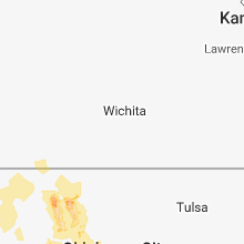
Kansas
| Local Time | Report Details |
|---|---|
| 9:25 PM CDT | Storm damage reported in morton county KS, 69.3 miles SW of Garden City, KS |
| 9:53 PM CDT | The emergency manager described vehicles that were lifted off the road at this location and overturne in stanton county KS, 60.1 miles WSW of Garden City, KS |
| 10:00 PM CDT | Half Dollar sized hail reported near Manter, KS, 56.4 miles WSW of Garden City, KS |
| 10:00 PM CDT | Tennis Ball sized hail reported near Manter, KS, 63.3 miles WSW of Garden City, KS, broadcast media twitter posted picture that viewer sent of tennis ball hail in manter. |
| 10:00 PM CDT | Golf Ball sized hail reported near Manter, KS, 62.9 miles WSW of Garden City, KS, photograph was received via social media. |
| 10:00 PM CDT | Storm damage reported in stanton county KS, 56.4 miles WSW of Garden City, KS |
| 11:13 PM CDT | Tree branches up to 3 inches in diameter snapped off. relayed by emergency mgr. time est fm rada in phillips county KS, 65.8 miles NNW of Hays, KS |
Oklahoma
| Local Time | Report Details |
|---|---|
| 2:15 AM CDT | Recorded on davis instrumen in kingfisher county OK, 31.4 miles NW of Oklahoma City, OK |
| 2:20 AM CDT | Measured on davis instrumen in kingfisher county OK, 31.4 miles NW of Oklahoma City, OK |
| 2:52 AM CDT | Storm damage reported in canadian county OK, 14.4 miles WSW of Oklahoma City, OK |
| 2:59 AM CDT | Cwop station d2113... 3 nnw fort cobb reservoi in caddo county OK, 57.6 miles WSW of Oklahoma City, OK |
| 3:00 AM CDT | Storm damage reported in canadian county OK, 13 miles WNW of Oklahoma City, OK |
| 3:05 AM CDT | Corrects previous tstm wnd gst report from 2 n yuko in canadian county OK, 13 miles WNW of Oklahoma City, OK |
| 3:10 AM CDT | Storm damage reported in canadian county OK, 13 miles WNW of Oklahoma City, OK |
| 3:15 AM CDT | Storm damage reported in canadian county OK, 13 miles WNW of Oklahoma City, OK |
| 4:05 AM CDT | Storm damage reported in grady county OK, 53.7 miles SSW of Oklahoma City, OK |
| 4:12 AM CDT | Cwop station f2394... 3 ese lawto in comanche county OK, 48 miles NNE of Wichita Falls, TX |
| 4:25 AM CDT | Storm damage reported in stephens county OK, 60.7 miles NE of Wichita Falls, TX |
| 4:30 AM CDT | Storm damage reported in stephens county OK, 60.7 miles NE of Wichita Falls, TX |
Connect with Interactive Hail Maps