

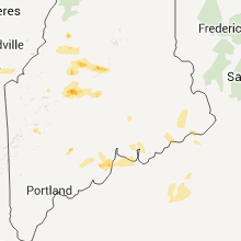
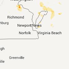
Hail Map for Monday, August 1, 2011

Number of Impacted Households on 8/1/2011
0
Impacted by 1" or Larger Hail
0
Impacted by 1.75" or Larger Hail
0
Impacted by 2.5" or Larger Hail
Square Miles of Populated Area Impacted on 8/1/2011
0
Impacted by 1" or Larger Hail
0
Impacted by 1.75" or Larger Hail
0
Impacted by 2.5" or Larger Hail


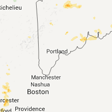

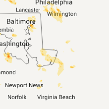


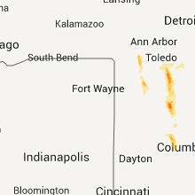


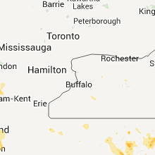
Cities Most Affected by Hail Storms of 8/1/2011
| Hail Size | Demographics of Zip Codes Affected | ||||||
|---|---|---|---|---|---|---|---|
| City | Count | Average | Largest | Pop Density | House Value | Income | Age |
| New Hyde Park, NY | 3 | 2.25 | 3.00 | 8453 | $270k | $71.0k | 44.0 |
| Upper Sandusky, OH | 3 | 2.08 | 2.75 | 67 | $85k | $38.4k | 41.7 |
| Mentor, OH | 3 | 1.83 | 2.00 | 1591 | $144k | $55.8k | 44.4 |
| Dupree, SD | 2 | 2.63 | 2.75 | 0 | $26k | $26.9k | 32.8 |
| White Plains, NY | 2 | 2.38 | 3.00 | 3581 | $389k | $83.6k | 43.8 |
| Stormville, NY | 2 | 1.75 | 1.75 | 354 | $199k | $79.8k | 41.6 |
| Amherst, MA | 2 | 1.75 | 1.75 | 449 | $178k | $42.6k | 24.0 |
| Hudson, NY | 2 | 1.75 | 1.75 | 187 | $92k | $32.7k | 43.2 |
| Newell, SD | 1 | 3.00 | 3.00 | 1 | $38k | $25.9k | 47.2 |
| Bayside, NY | 1 | 2.75 | 2.75 | 0 | $0k | $0.0k | 0.0 |
| Medina, OH | 1 | 2.00 | 2.00 | 480 | $158k | $57.7k | 40.0 |
| Great Neck, NY | 1 | 1.75 | 1.75 | 5265 | $538k | $97.4k | 42.7 |
| Cherry Hill, NJ | 1 | 1.75 | 1.75 | 3154 | $137k | $52.1k | 41.7 |
| Plain City, OH | 1 | 1.75 | 1.75 | 123 | $141k | $50.9k | 39.0 |
| Garden City, NY | 1 | 1.75 | 1.75 | 3736 | $420k | $97.9k | 42.3 |
| Nevada, OH | 1 | 1.75 | 1.75 | 43 | $80k | $40.7k | 39.6 |
| Ludlow, MA | 1 | 1.75 | 1.75 | 740 | $127k | $47.1k | 42.6 |
| Voorhees, NJ | 1 | 1.75 | 1.75 | 2615 | $180k | $68.4k | 42.6 |
| Wadsworth, OH | 1 | 1.75 | 1.75 | 658 | $135k | $53.0k | 40.2 |
| Woodville, OH | 1 | 1.75 | 1.75 | 139 | $112k | $48.4k | 39.9 |
| Salisbury, MD | 1 | 1.75 | 1.75 | 529 | $93k | $38.3k | 32.9 |
| Streetsboro, OH | 1 | 1.75 | 1.75 | 823 | $119k | $48.6k | 37.8 |
| Jersey City, NJ | 1 | 1.75 | 1.75 | 9713 | $132k | $38.2k | 34.7 |
| Ralph, SD | 1 | 1.75 | 1.75 | 0 | $43k | $21.9k | 52.5 |
| Muncy Valley, PA | 1 | 1.75 | 1.75 | 12 | $75k | $34.2k | 46.8 |
Hail and Wind Damage Spotted on 8/1/2011
Filter by Report Type:Hail ReportsWind Reports
States Impacted
Minnesota, Ohio, Connecticut, Massachusetts, Pennsylvania, New York, South Dakota, West Virginia, Maine, Arkansas, Virginia, Maryland, New Jersey, Montana, Idaho, New Hampshire, California, WisconsinMinnesota
| Local Time | Report Details |
|---|---|
| 12:22 PM UTC | I-94 mile post 104 in douglas county MN, 65.5 miles NNE of Montevideo, MN |
| 12:30 PM UTC | Power lines down...large trees uprooted...widespread tree damage around town. time estimate in pope county MN, 51 miles NNE of Montevideo, MN |
| 12:30 PM UTC | Sixteen mile long path of damage with a swath about six to eight miles wide. many trees uprooted and power lines down. damage extended from farwell to north end of star in pope county MN, 51 miles NNE of Montevideo, MN |
| 12:45 PM UTC | Numerous trees and power lines down across southern and western douglas county...more reports will follo in douglas county MN, 61.3 miles N of Montevideo, MN |
| 1:10 PM UTC | 6 inch diameter branch down in yard...numerous smaller branche in pope county MN, 41.6 miles NNE of Montevideo, MN |
| 1:10 PM UTC | 6 inch diameter branch down in yard...numerous smaller branc in pope county MN, 41.6 miles NNE of Montevideo, MN |
| 1:15 PM UTC | Quarter sized hail reported near Glenwood, MN, 40.6 miles NNE of Montevideo, MN |
| 2:50 PM UTC | Ping Pong Ball sized hail reported near Spicer, MN, 42.9 miles ENE of Montevideo, MN |
| 4:56 PM UTC | 6-8 in branches down in eastern litchfield in meeker county MN, 59.3 miles ENE of Montevideo, MN |
| 5:24 PM UTC | Some large branches snappe in wright county MN, 45.8 miles W of Minneapolis, MN |
| 5:24 PM UTC | Winds e 49 mph many small 2 - 3 inch branches doown on power lines and roadways some large branches snapped in wright county MN, 45.8 miles W of Minneapolis, MN |
| 5:30 PM UTC | Tree down across roa in wright county MN, 32.2 miles WNW of Minneapolis, MN |
| 5:40 PM UTC | Trees down blocking a road in mcleod county MN, 45.8 miles WSW of Minneapolis, MN |
| 5:50 PM UTC | Large 12 inch tree down in hennepin county MN, 22.5 miles W of Minneapolis, MN |
| 5:50 PM UTC | Several large trees down near county roads 26 and 110 in northeast minnetrista. power lines also reported dow in hennepin county MN, 19.9 miles W of Minneapolis, MN |
| 5:50 PM UTC | Tree down across county road 1 in hennepin county MN, 21.6 miles W of Minneapolis, MN |
| 6:05 PM UTC | 6 inch branches down at 24th and garfield ave s. time estimated by rada in hennepin county MN, 1.3 miles S of Minneapolis, MN |
| 6:05 PM UTC | 1.5 to 2 inch brances down at buchanan and winter streets. time estimated by rada in hennepin county MN, 1.3 miles S of Minneapolis, MN |
| 6:23 PM UTC | Quarter sized hail reported near Henderson, MN, 44.4 miles SW of Minneapolis, MN, winds so strong blowing 2 ft diameter nearly over |
| 6:27 PM UTC | Highway 55 and 101 in hennepin county MN, 16.8 miles WNW of Minneapolis, MN |
| 6:29 PM UTC | 12 inch diameter tree down in hennepin county MN, 4.2 miles NNE of Minneapolis, MN |
| 6:30 PM UTC | Large 12 inch tree down in hennepin county MN, 22.5 miles W of Minneapolis, MN |
| 6:50 PM UTC | Numerous 4 inch branches down at u of m in ramsey county MN, 8.3 miles ESE of Minneapolis, MN |
| 6:50 PM UTC | Tree uprooted. also numerous 4 inch branches down at u of m st paul campu in ramsey county MN, 8.3 miles ESE of Minneapolis, MN |
| 6:55 PM UTC | 3-5 inch branches snapped in washington county MN, 19.8 miles ESE of Minneapolis, MN |
| 7:00 PM UTC | 18 inch tree down at university and central in hennepin county MN, 1.3 miles S of Minneapolis, MN |
| 7:15 PM UTC | 1.5 to 2 inch brances down at buchanan and winter streets in hennepin county MN, 1.3 miles S of Minneapolis, MN |
| 7:20 PM UTC | Large branches down in rice county MN, 43.2 miles SSE of Minneapolis, MN |
| 7:52 PM UTC | Mndot mesonet observation measured a peak wind gust of 59 mp in goodhue county MN, 44.9 miles SSE of Minneapolis, MN |
| 7:52 PM UTC | Mndot mesonet observation measured a peak wind gust of 59 mp in goodhue county MN, 42.6 miles SSE of Minneapolis, MN |
| 8:20 PM UTC | 2 small trees down over the driveway. large tree broken off at the to in goodhue county MN, 47.6 miles SSE of Minneapolis, MN |
| 10:59 AM UTC | Power line down along with 2 large branches in lac qui parle county MN, 26.8 miles NW of Montevideo, MN |
Ohio
| Local Time | Report Details |
|---|---|
| 1:59 PM UTC | Half Dollar sized hail reported near Willoughby, OH, 17.7 miles NE of Cleveland, OH |
| 2:00 PM UTC | Quarter sized hail reported near Mentor, OH, 22.6 miles NE of Cleveland, OH |
| 2:02 PM UTC | Half Dollar sized hail reported near Mentor, OH, 22.6 miles NE of Cleveland, OH |
| 2:07 PM UTC | Quarter sized hail reported near Willoughby, OH, 17.7 miles NE of Cleveland, OH |
| 2:13 PM UTC | Quarter sized hail reported near Willoughby, OH, 17.7 miles NE of Cleveland, OH |
| 2:13 PM UTC | Hen Egg sized hail reported near Mentor, OH, 22.6 miles NE of Cleveland, OH |
| 2:15 PM UTC | Golf Ball sized hail reported near Mentor, OH, 22.6 miles NE of Cleveland, OH, golf ball size hail and branches down. |
| 2:19 PM UTC | Quarter sized hail reported near Willoughby, OH, 17.7 miles NE of Cleveland, OH |
| 2:21 PM UTC | Quarter sized hail reported near Eastlake, OH, 17.2 miles NE of Cleveland, OH |
| 2:22 PM UTC | Golf Ball sized hail reported near Mentor, OH, 22.6 miles NE of Cleveland, OH |
| 2:27 PM UTC | Quarter sized hail reported near Kirtland, OH, 19.3 miles ENE of Cleveland, OH |
| 3:48 PM UTC | Quarter sized hail reported near Cleveland, OH, 1.8 miles SSE of Cleveland, OH |
| 3:53 PM UTC | Quarter sized hail reported near Euclid, OH, 10.6 miles NE of Cleveland, OH |
| 3:55 PM UTC | Quarter sized hail reported near Cleveland, OH, 1.8 miles SSE of Cleveland, OH |
| 4:05 PM UTC | Quarter sized hail reported near Mayfield Heights, OH, 12.5 miles E of Cleveland, OH |
| 4:21 PM UTC | Quarter sized hail reported near South Russell, OH, 19.4 miles ESE of Cleveland, OH |
| 4:34 PM UTC | Quarter sized hail reported near Moreland Hills, OH, 14.2 miles ESE of Cleveland, OH |
| 4:46 PM UTC | Quarter sized hail reported near Aurora, OH, 22.6 miles SE of Cleveland, OH |
| 4:55 PM UTC | Quarter sized hail reported near Chagrin Falls, OH, 19.8 miles ESE of Cleveland, OH |
| 5:03 PM UTC | Quarter sized hail reported near Mantua, OH, 28.9 miles ESE of Cleveland, OH |
| 5:06 PM UTC | Quarter sized hail reported near Streetsboro, OH, 25.4 miles SE of Cleveland, OH |
| 5:08 PM UTC | Golf Ball sized hail reported near Streetsboro, OH, 25.4 miles SE of Cleveland, OH |
| 5:17 PM UTC | Quarter sized hail reported near Chardon, OH, 25.5 miles ENE of Cleveland, OH |
| 5:39 PM UTC | Quarter sized hail reported near Genoa, OH, 86.6 miles W of Cleveland, OH |
| 5:48 PM UTC | Golf Ball sized hail reported near Woodville, OH, 86.7 miles W of Cleveland, OH |
| 6:16 PM UTC | Quarter sized hail reported near Helena, OH, 82.7 miles W of Cleveland, OH |
| 6:20 PM UTC | Quarter sized hail reported near Helena, OH, 83.9 miles W of Cleveland, OH |
| 6:20 PM UTC | Quarter sized hail reported near Vermilion, OH, 33.3 miles W of Cleveland, OH |
| 6:22 PM UTC | Quarter sized hail reported near Wadsworth, OH, 33.5 miles S of Cleveland, OH |
| 6:30 PM UTC | Quarter sized hail reported near Akron, OH, 30.6 miles SSE of Cleveland, OH |
| 6:30 PM UTC | Hen Egg sized hail reported near Medina, OH, 26.8 miles SSW of Cleveland, OH |
| 6:32 PM UTC | Twigs and small branches dow in summit county OH, 30.6 miles SSE of Cleveland, OH |
| 6:40 PM UTC | Quarter sized hail reported near Fairlawn, OH, 26.8 miles S of Cleveland, OH |
| 6:48 PM UTC | Twigs and small branches dow in portage county OH, 35.4 miles SE of Cleveland, OH |
| 6:52 PM UTC | Quarter sized hail reported near Fostoria, OH, 85.4 miles NNW of Columbus, OH |
| 6:53 PM UTC | Golf Ball sized hail reported near Wadsworth, OH, 33.5 miles S of Cleveland, OH |
| 6:58 PM UTC | Half Dollar sized hail reported near Wadsworth, OH, 33.5 miles S of Cleveland, OH |
| 7:00 PM UTC | Quarter sized hail reported near Wadsworth, OH, 33.5 miles S of Cleveland, OH |
| 7:00 PM UTC | Half Dollar sized hail reported near Wadsworth, OH, 33.5 miles S of Cleveland, OH |
| 7:09 PM UTC | Half Dollar sized hail reported near Wadsworth, OH, 33.5 miles S of Cleveland, OH |
| 7:16 PM UTC | Quarter sized hail reported near Wadsworth, OH, 33.5 miles S of Cleveland, OH |
| 7:30 PM UTC | Golf Ball sized hail reported near Upper Sandusky, OH, 61.6 miles NNW of Columbus, OH |
| 7:30 PM UTC | Baseball sized hail reported near Upper Sandusky, OH, 61.6 miles NNW of Columbus, OH |
| 7:33 PM UTC | Golf Ball sized hail reported near Nevada, OH, 60.7 miles N of Columbus, OH |
| 7:40 PM UTC | Half Dollar sized hail reported near Upper Sandusky, OH, 61.6 miles NNW of Columbus, OH |
| 7:45 PM UTC | Golf Ball sized hail reported near Upper Sandusky, OH, 61.6 miles NNW of Columbus, OH |
| 9:30 PM UTC | Power poles and trees down in union county OH, 33.5 miles NW of Columbus, OH |
| 9:45 PM UTC | Two trees down. power lines on houses in union county OH, 17.5 miles NW of Columbus, OH |
| 5:50 PM EDT | Golf Ball sized hail reported near Plain City, OH, 16.7 miles NW of Columbus, OH |
Connecticut
| Local Time | Report Details |
|---|---|
| 4:52 PM UTC | Quarter sized hail reported near Bethel, CT, 55.7 miles NNE of Brooklyn, NY |
| 5:19 PM UTC | Quarter sized hail reported near Bethel, CT, 55.7 miles NNE of Brooklyn, NY, nickle to quarter size hail. |
| 5:23 PM UTC | Tree down on power line. numerous downed large limbs as wel in fairfield county CT, 55.9 miles NNE of Brooklyn, NY |
| 5:30 PM UTC | Large tree down along south street between high st exit and bainbridge blvd. road close in fairfield county CT, 55.9 miles NNE of Brooklyn, NY |
| 6:05 PM UTC | Multiple branches down on saxon road in fairfield county CT, 55.7 miles NNE of Brooklyn, NY |
| 8:10 PM UTC | Quarter sized hail reported near Harwinton, CT, 84.2 miles W of Providence, RI |
| 8:29 PM UTC | Quarter sized hail reported near Harwinton, CT, 84.2 miles W of Providence, RI |
| 9:38 PM UTC | Quarter sized hail reported near Newington, CT, 68.7 miles W of Providence, RI |
| 10:28 PM UTC | Quarter sized hail reported near Waterbury, CT, 77.7 miles NE of Brooklyn, NY, one inch size hail |
| 10:38 PM UTC | Quarter sized hail reported near Waterbury, CT, 77.7 miles NE of Brooklyn, NY, one inch size hail |
| 6:40 PM EDT | Quarter sized hail reported near Naugatuck, CT, 73.7 miles NE of Brooklyn, NY, one inch hail. |
| 6:59 PM EDT | Quarter sized hail reported near Ansonia, CT, 65.7 miles NE of Brooklyn, NY, clifton avenue...one inch size hail. |
| 11:06 PM UTC | Trees dow in new haven county CT, 64.8 miles NE of Brooklyn, NY |
| 11:06 PM UTC | Trees dow in fairfield county CT, 63.6 miles NE of Brooklyn, NY |
| 7:15 PM EDT | Quarter sized hail reported near Ansonia, CT, 65.7 miles NE of Brooklyn, NY, quater size hail |
| 11:23 PM UTC | Trees dow in fairfield county CT, 63.6 miles NE of Brooklyn, NY |
| 11:27 PM UTC | Trees dow in new haven county CT, 64.8 miles NE of Brooklyn, NY |
Massachusetts
| Local Time | Report Details |
|---|---|
| 5:15 PM UTC | Ping Pong Ball sized hail reported near Amherst, MA, 68.7 miles NW of Providence, RI |
| 5:28 PM UTC | Golf Ball sized hail reported near Amherst, MA, 68.7 miles NW of Providence, RI |
| 5:37 PM UTC | Quarter sized hail reported near Amherst, MA, 68.7 miles NW of Providence, RI, media |
| 5:38 PM UTC | Golf Ball sized hail reported near Amherst, MA, 68.7 miles NW of Providence, RI |
| 5:48 PM UTC | Quarter sized hail reported near Amherst, MA, 68.7 miles NW of Providence, RI |
| 6:11 PM UTC | Quarter sized hail reported near Belchertown, MA, 59.4 miles WNW of Providence, RI |
| 6:25 PM UTC | Golf Ball sized hail reported near Ludlow, MA, 59.9 miles WNW of Providence, RI, falling on moore st |
| 6:37 PM UTC | Downed trees and power lines on route 142 in franklin county MA, 76.7 miles E of Schenectady, NY |
| 7:45 PM UTC | Ping Pong Ball sized hail reported near Belchertown, MA, 59.4 miles WNW of Providence, RI |
| 7:50 PM UTC | Quarter sized hail reported near Northfield, MA, 76.7 miles E of Schenectady, NY |
| 8:33 PM UTC | Quarter sized hail reported near Erving, MA, 73.8 miles NW of Providence, RI |
| 8:48 PM UTC | Quarter sized hail reported near Leverett, MA, 70.6 miles NW of Providence, RI |
| 8:55 PM UTC | Tree on power lines in franklin county MA, 70.6 miles NW of Providence, RI |
| 9:15 PM UTC | Quarter sized hail reported near Shutesbury, MA, 66.7 miles NW of Providence, RI |
Pennsylvania
| Local Time | Report Details |
|---|---|
| 5:41 PM UTC | Quarter sized hail reported near Monroe, PA, 44.1 miles WNW of Scranton, PA |
| 5:45 PM UTC | Quarter sized hail reported near Monroe, PA, 44.1 miles WNW of Scranton, PA |
| 2:35 PM EDT | Golf Ball sized hail reported near Laporte, PA, 43.1 miles W of Scranton, PA, lost lake on route 220 |
| 6:37 PM UTC | Quarter sized hail reported near Laporte, PA, 43.1 miles W of Scranton, PA |
| 6:54 PM UTC | Trees down with structural damage reported on terminal rd in cumberland county PA, 53.8 miles SE of State College, PA |
| 7:04 PM UTC | Quarter sized hail reported near Pine Creek, PA, 37 miles NE of State College, PA |
| 7:15 PM UTC | Quarter sized hail reported near Dunnstable, PA, 36.5 miles NE of State College, PA |
| 3:15 PM EDT | Quarter sized hail reported near Monaghan, PA, 62.2 miles NNW of Baltimore, MD |
| 7:20 PM UTC | Quarter sized hail reported near Jersey Shore, PA, 41.7 miles NE of State College, PA |
| 7:23 PM UTC | Quarter sized hail reported near Irwin, PA, 17.7 miles ESE of Pittsburgh, PA |
| 7:29 PM UTC | Quarter sized hail reported near Penn, PA, 17.3 miles ESE of Pittsburgh, PA |
| 7:29 PM UTC | Trees down in armstrong county PA, 49.4 miles ENE of Pittsburgh, PA |
| 7:33 PM UTC | Quarter sized hail reported near Penn, PA, 15 miles ESE of Pittsburgh, PA |
| 7:36 PM UTC | Quarter sized hail reported near Hickory, PA, 84.7 miles NNE of Pittsburgh, PA |
| 7:50 PM UTC | Numerous large trees down in schuylkill county PA, 68.9 miles SW of Scranton, PA |
| 8:00 PM UTC | Quarter sized hail reported near Grant, PA, 59.2 miles ENE of Pittsburgh, PA |
| 8:09 PM UTC | Quarter sized hail reported near Glen Campbell, PA, 50.9 miles W of State College, PA |
| 8:10 PM UTC | Large trees down in schuylkill county PA, 69.4 miles SSW of Scranton, PA |
| 8:20 PM UTC | Numerous large trees down in schuylkill county PA, 57 miles SSW of Scranton, PA |
| 8:25 PM UTC | Trees down on a home in camelot estates in clinton county PA, 28.7 miles NE of State College, PA |
| 8:25 PM UTC | Tree reported down in ole in berks county PA, 70.7 miles S of Scranton, PA |
| 8:29 PM UTC | Quarter sized hail reported near Penn, PA, 17.3 miles ESE of Pittsburgh, PA |
| 8:30 PM UTC | Widespread trees and wires down around mill hall in clinton county PA, 28.7 miles NE of State College, PA |
| 8:34 PM UTC | Tree reported down in tulpehocke in berks county PA, 73.7 miles SSW of Scranton, PA |
| 8:50 PM UTC | Trees down in mahoning townshi in carbon county PA, 41.8 miles S of Scranton, PA |
| 8:55 PM UTC | Trees down in king of prussi in montgomery county PA, 83.9 miles WSW of Brooklyn, NY |
| 9:36 PM UTC | Trees down along route 18 in greene county PA, 40.4 miles SSW of Pittsburgh, PA |
| 9:53 PM UTC | Quarter sized hail reported near Sharon Hill, PA, 83.3 miles ENE of Baltimore, MD, nickel up to quarter size hail reported in sharon hill. |
| 9:56 PM UTC | Quarter sized hail reported near Tinicum, PA, 83.3 miles ENE of Baltimore, MD, quarter size hail reported at the philadelphia international airport. |
| 9:56 PM UTC | 60 mph gust measured at the philadelphia international airpor in philadelphia county PA, 83.3 miles ENE of Baltimore, MD |
| 10:20 PM UTC | Numerous trees down in dauphin county PA, 65.9 miles N of Baltimore, MD |
| 10:20 PM UTC | Numerous trees down. route 343 closed due to trees dow in lebanon county PA, 75.8 miles N of Baltimore, MD |
| 10:24 PM UTC | Quarter sized hail reported near Upper Chichester, PA, 72.7 miles ENE of Baltimore, MD, quarter size hail reported in boothwyn. |
| 10:25 PM UTC | Quarter sized hail reported near Upper Chichester, PA, 72.6 miles ENE of Baltimore, MD, quarter size hail reported in boothwyn. |
| 11:10 PM UTC | Multiple trees and wires down in cumberland county PA, 49.4 miles SSE of State College, PA |
| 11:10 PM UTC | Multiple trees and wires down in cumberland county PA, 48.1 miles SE of State College, PA |
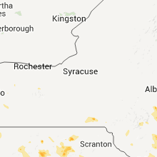
New York
| Local Time | Report Details |
|---|---|
| 6:45 PM UTC | Quarter sized hail reported near Coxsackie, NY, 31.9 miles SSE of Schenectady, NY |
| 7:10 PM UTC | Quarter sized hail reported near Stuyvesant, NY, 30.3 miles SSE of Schenectady, NY |
| 7:15 PM UTC | Ping Pong Ball sized hail reported near Hudson, NY, 39.6 miles S of Schenectady, NY |
| 7:15 PM UTC | Golf Ball sized hail reported near Hudson, NY, 39.6 miles S of Schenectady, NY |
| 7:17 PM UTC | Quarter sized hail reported near Greenport, NY, 40.6 miles SSE of Schenectady, NY |
| 7:20 PM UTC | Half Dollar sized hail reported near Claverack, NY, 42.4 miles SSE of Schenectady, NY |
| 7:20 PM UTC | Golf Ball sized hail reported near Claverack, NY, 42.9 miles SSE of Schenectady, NY |
| 4:05 PM EDT | Quarter sized hail reported near New Hyde Park, NY, 16 miles E of Brooklyn, NY |
| 8:10 PM UTC | Quarter sized hail reported near Livingston, NY, 49.8 miles S of Schenectady, NY |
| 4:13 PM EDT | Golf Ball sized hail reported near New Hyde Park, NY, 16 miles E of Brooklyn, NY, golf ball size hail |
| 4:15 PM EDT | Quarter sized hail reported near Garden City, NY, 18.6 miles E of Brooklyn, NY |
| 8:15 PM UTC | Golf Ball sized hail reported near Great Neck, NY, 15.5 miles ENE of Brooklyn, NY, golf ball size hail |
| 8:20 PM UTC | Quarter sized hail reported near Hempstead, NY, 19.5 miles E of Brooklyn, NY |
| 8:20 PM UTC | Quarter sized hail reported near Taghkanic, NY, 48.8 miles SSE of Schenectady, NY |
| 4:24 PM EDT | Hen Egg sized hail reported near New Hyde Park, NY, 16 miles E of Brooklyn, NY, multiple spotters report 2.0 inch hail in new hyde park |
| 4:28 PM EDT | Golf Ball sized hail reported near Garden City, NY, 18.6 miles E of Brooklyn, NY |
| 4:30 PM EDT | Tea Cup sized hail reported near New Hyde Park, NY, 16 miles E of Brooklyn, NY, spotter measured hail at 3.0 inches. car windshield shattered on durham road. |
| 8:45 PM UTC | Quarter sized hail reported near Pleasant Valley, NY, 73.5 miles N of Brooklyn, NY |
| 8:50 PM UTC | Ping Pong Ball sized hail reported near Pleasant Valley, NY, 72.1 miles N of Brooklyn, NY |
| 8:53 PM UTC | Half Dollar sized hail reported near Stony Point, NY, 39.2 miles N of Brooklyn, NY |
| 8:54 PM UTC | Quarter sized hail reported near Hyde Park, NY, 71.3 miles S of Schenectady, NY |
| 8:55 PM UTC | Quarter sized hail reported near La Grange, NY, 67.2 miles N of Brooklyn, NY |
| 8:57 PM UTC | Quarter sized hail reported near Rockville Centre, NY, 18.5 miles E of Brooklyn, NY |
| 9:09 PM UTC | Quarter sized hail reported near Croton-On-Hudson, NY, 35.4 miles N of Brooklyn, NY |
| 9:11 PM UTC | Quarter sized hail reported near Union Vale, NY, 67.4 miles N of Brooklyn, NY |
| 9:29 PM UTC | Quarter sized hail reported near Pleasant Valley, NY, 69.6 miles S of Schenectady, NY |
| 9:31 PM UTC | Golf Ball sized hail reported near East Fishkill, NY, 61.8 miles NNE of Brooklyn, NY |
| 9:53 PM UTC | Tree down between rt 301 and old rt 301 in putnam county NY, 54.4 miles NNE of Brooklyn, NY |
| 9:55 PM UTC | Quarter sized hail reported near Sleepy Hollow, NY, 28.9 miles NNE of Brooklyn, NY |
| 10:00 PM UTC | Half Dollar sized hail reported near White Plains, NY, 25.6 miles NNE of Brooklyn, NY |
| 10:00 PM UTC | Golf Ball sized hail reported near White Plains, NY, 25.6 miles NNE of Brooklyn, NY, golf ball size hail |
| 10:04 PM UTC | Tea Cup sized hail reported near White Plains, NY, 25.6 miles NNE of Brooklyn, NY, three inch hail |
| 10:05 PM UTC | Multiple branches down near tappan zee bridge in westchester county NY, 26.1 miles NNE of Brooklyn, NY |
| 10:11 PM UTC | Golf Ball sized hail reported near , , 23 miles NNE of Brooklyn, NY, golf ball size hail along i-87 |
| 10:20 PM UTC | Quarter sized hail reported near White Plains, NY, 25.6 miles NNE of Brooklyn, NY, 1 mile south of white plains |
| 10:23 PM UTC | Quarter sized hail reported near Harrison, NY, 28.1 miles NE of Brooklyn, NY |
| 10:31 PM UTC | Golf Ball sized hail reported near East Fishkill, NY, 61.8 miles NNE of Brooklyn, NY |
| 10:45 PM UTC | Quarter sized hail reported near Scarsdale, NY, 23.3 miles NNE of Brooklyn, NY |
| 11:00 PM UTC | Quarter sized hail reported near New Castle, NY, 34.4 miles NNE of Brooklyn, NY |
| 11:21 PM UTC | Half Dollar sized hail reported near New York, NY, 12.3 miles NE of Brooklyn, NY, bronx coop observer |
| 7:36 PM EDT | Baseball sized hail reported near New York, NY, 13.4 miles ENE of Brooklyn, NY, baseball size hail. car damage |
| 11:57 PM UTC | Scattered branches and limbs and a few trees down across the tow in suffolk county NY, 68.1 miles ENE of Brooklyn, NY |
| 12:15 AM UTC | Westhampton beach asos in suffolk county NY, 72.8 miles E of Brooklyn, NY |
| 12:15 AM UTC | Large branches down and power pole damage along route 58 near applebee in suffolk county NY, 72.9 miles ENE of Brooklyn, NY |
| 12:35 AM UTC | Numerous trees down across the tow in suffolk county NY, 78.2 miles E of Brooklyn, NY |
| 12:35 AM UTC | Branches down across the town. wires down on county road 3 in suffolk county NY, 70.5 miles E of Brooklyn, NY |
| 3:21 AM UTC | Tree down at 229 geiger r in ulster county NY, 65.3 miles ENE of Scranton, PA |
| 3:36 AM UTC | Trees and wires down at 89 mountain r in ulster county NY, 68.6 miles NNW of Brooklyn, NY |
| 3:59 AM UTC | Multiple trees down along route 2 in ulster county NY, 62.6 miles S of Schenectady, NY |
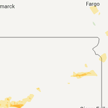
South Dakota
| Local Time | Report Details |
|---|---|
| 6:45 PM UTC | Quarter sized hail reported near Ludlow, SD, 118.1 miles ESE of Miles City, MT |
| 6:45 PM UTC | Storm damage reported in harding county SD, 118.1 miles ESE of Miles City, MT |
| 7:05 PM UTC | Ping Pong Ball sized hail reported near Ralph, SD, 125.7 miles N of Rapid City, SD |
| 7:10 PM UTC | Quarter sized hail reported near Belle Fourche, SD, 89.4 miles NNW of Rapid City, SD |
| 7:10 PM UTC | Storm damage reported in harding county SD, 89.4 miles NNW of Rapid City, SD |
| 7:30 PM UTC | Golf Ball sized hail reported near Ralph, SD, 125.8 miles N of Rapid City, SD |
| 8:20 PM UTC | Storm damage reported in butte county SD, 71.8 miles N of Rapid City, SD |
| 8:30 PM UTC | Quarter sized hail reported near Newell, SD, 71.1 miles N of Rapid City, SD |
| 8:30 PM UTC | Storm damage reported in butte county SD, 71.1 miles N of Rapid City, SD |
| 8:30 PM UTC | Estimated 80-90 mph winds took down a corral and a grannery. 5 inch diameter trees twisted off. 1.25 inch measured rainfall. pea-quarter size hai in butte county SD, 71.1 miles N of Rapid City, SD |
| 8:40 PM UTC | Tea Cup sized hail reported near Newell, SD, 68.7 miles N of Rapid City, SD |
| 8:44 PM UTC | Storm damage reported in butte county SD, 65.6 miles N of Rapid City, SD |
| 9:22 PM UTC | Storm damage reported in meade county SD, 69.2 miles NNE of Rapid City, SD |
| 9:22 PM UTC | Quarter sized hail reported near Mud Butte, SD, 69.2 miles NNE of Rapid City, SD |
| 9:30 PM UTC | Quarter sized hail reported near Faith, SD, 71.5 miles NNE of Rapid City, SD |
| 9:30 PM UTC | Shaking the house in meade county SD, 71.5 miles NNE of Rapid City, SD |
| 9:45 PM UTC | Large tree branches broken in meade county SD, 74.2 miles NNE of Rapid City, SD |
| 9:50 PM UTC | 4-5 inch diameter tree branches broken in perkins county SD, 78.1 miles NNE of Rapid City, SD |
| 9:50 PM UTC | Half Dollar sized hail reported near Faith, SD, 78.1 miles NNE of Rapid City, SD |
| 10:15 PM UTC | Storm damage reported in perkins county SD, 88.1 miles NE of Rapid City, SD |
| 10:26 PM UTC | Storm damage reported in meade county SD, 87.9 miles NE of Rapid City, SD |
| 10:40 PM UTC | Storm damage reported in meade county SD, 39.6 miles NNE of Rapid City, SD |
| 10:40 PM UTC | Storm damage reported in ziebach county SD, 89.6 miles WNW of Pierre, SD |
| 10:45 PM UTC | Worst wind hes seen in years in ziebach county SD, 83.4 miles NW of Pierre, SD |
| 10:45 PM UTC | Quarter sized hail reported near Dupree, SD, 83.4 miles NW of Pierre, SD |
| 10:55 PM UTC | Storm damage reported in ziebach county SD, 80.1 miles NW of Pierre, SD |
| 10:55 PM UTC | Baseball sized hail reported near Dupree, SD, 80.1 miles NW of Pierre, SD |
| 10:57 PM UTC | Tennis Ball sized hail reported near Dupree, SD, 77.1 miles NW of Pierre, SD, also had 40 to 50 mph winds. |
| 11:15 PM UTC | Quarter sized hail reported near Isabel, SD, 73.2 miles NW of Pierre, SD |
| 12:10 AM UTC | Sdsu mesonet sit in fall river county SD, 59.3 miles SW of Rapid City, SD |
| 4:15 AM UTC | Storm damage reported in jackson county SD, 68.7 miles WSW of Pierre, SD |
| 4:30 AM UTC | Storm damage reported in jackson county SD, 59 miles SW of Pierre, SD |
| 4:35 AM UTC | Estimated 60 to 70 mph winds in jones county SD, 42.3 miles SSW of Pierre, SD |
| 5:15 AM UTC | Storm damage reported in jones county SD, 40.4 miles SSW of Pierre, SD |
| 5:15 AM UTC | Estimated 70 plus mph winds. shingles blown off of buildings. estimated 2 inches of rain in 30 minutes in jones county SD, 39.4 miles SSW of Pierre, SD |
| 5:40 AM UTC | Measured at vivian rwis in stanley county SD, 9.6 miles S of Pierre, SD |
| 6:00 AM UTC | Storm damage reported in lyman county SD, 34.8 miles SSE of Pierre, SD |
| 6:00 AM UTC | Estimated winds 60 to 70 mph in lyman county SD, 30.5 miles SE of Pierre, SD |
| 6:00 AM UTC | Fort pierre raws...radar estimated time in lyman county SD, 17.4 miles S of Pierre, SD |
| 6:50 AM UTC | 4 to 5 inch diameter tree branches down in hyde county SD, 47.1 miles ESE of Pierre, SD |
| 7:35 AM UTC | Hand county em davis weather station max wind gus in hand county SD, 68.1 miles E of Pierre, SD |
| 7:55 AM UTC | Storm damage reported in spink county SD, 53.9 miles S of Aberdeen, SD |
| 8:20 AM UTC | Storm damage reported in spink county SD, 53.8 miles S of Aberdeen, SD |
| 10:00 AM UTC | Tree damage in town...including a 36 inch diameter tree down in hamlin county SD, 66.4 miles WSW of Montevideo, MN |
| 10:30 AM UTC | 8 in diameter tree branches down in grant county SD, 54 miles WNW of Montevideo, MN |
West Virginia
| Local Time | Report Details |
|---|---|
| 7:00 PM UTC | Half Dollar sized hail reported near Augusta, WV, 72.5 miles ENE of Elkins, WV, quarter to half dollar size hail |
| 7:00 PM UTC | Multiple tree branches down along us 50. branches at least 2 inches in diamete in hampshire county WV, 72.5 miles ENE of Elkins, WV |
| 9:58 PM UTC | Storm damage reported in berkeley county WV, 73.9 miles W of Baltimore, MD |
| 10:02 PM UTC | Storm damage reported in berkeley county WV, 74.1 miles W of Baltimore, MD |
| 10:10 PM UTC | Numerous large limbs down on back creek valley road in berkeley county WV, 81.6 miles W of Baltimore, MD |
| 10:10 PM UTC | Tree on top of car and blocking road on back creek valley road in berkeley county WV, 81.6 miles W of Baltimore, MD |
| 10:17 PM UTC | Storm damage reported in berkeley county WV, 73.9 miles W of Baltimore, MD |
Maine
| Local Time | Report Details |
|---|---|
| 7:15 PM UTC | Poplar tree took down power line on the west side of eagle lake. time is estimate in aroostook county ME, 30.1 miles WNW of Caribou, ME |
| 9:10 PM UTC | Large tree took down power line on the river roa in aroostook county ME, 0.1 miles NE of Caribou, ME |
| 9:20 PM UTC | Large tree down on route 1a. time is estimate in aroostook county ME, 9.3 miles ENE of Caribou, ME |
| 9:20 PM UTC | Trees down along the noyes road. time is estimate in aroostook county ME, 2.1 miles NE of Caribou, ME |
| 9:55 PM UTC | Quarter sized hail reported near Carthage, ME, 67 miles N of Portland, ME, time estimated |
| 10:00 PM UTC | Quarter sized hail reported near Lily Bay, ME, 67 miles NW of Bangor, ME, quarter size hail near lily bay. time is estimated. |
| 12:35 AM UTC | Quarter sized hail reported near Guilford, ME, 39.6 miles NW of Bangor, ME, law enforcement reported quarter size hail in guilford. |
| 12:45 AM UTC | Quarter sized hail reported near Dover-Foxcroft, ME, 34.5 miles NW of Bangor, ME, law enforcement reported quarter sized hail in dover-foxcroft. |
Arkansas
| Local Time | Report Details |
|---|---|
| 8:51 PM UTC | Numerous large pine trees down in the greens chapel community in sevier county AR, 17.9 miles NW of Nashville, AR |
| 9:06 PM UTC | Trees down blocking the road at the junction of hwys 70 and 71 in sevier county AR, 20.7 miles WNW of Nashville, AR |
Virginia
| Local Time | Report Details |
|---|---|
| 9:03 PM UTC | Trees down along hughesville road and adjacent properties in loudoun county VA, 57.9 miles WSW of Baltimore, MD |
| 9:05 PM UTC | Quarter sized hail reported near Hamilton, VA, 58.4 miles WSW of Baltimore, MD, second round of hail associated with core of second storm in close proximity |
| 9:07 PM UTC | Trees down at wakefield chapel road and little river turnpike in fairfax county VA, 46 miles SW of Baltimore, MD |
| 9:12 PM UTC | 14 inch diameter trees down at braddock road and ravensworth road in fairfax county VA, 46.3 miles SW of Baltimore, MD |
| 9:15 PM UTC | 5 inch limbs down in fairfax county VA, 50 miles SW of Baltimore, MD |
| 9:35 PM UTC | Trees down along rt 50 between aldie and arcol in loudoun county VA, 57.2 miles WSW of Baltimore, MD |
| 10:05 PM UTC | A small plane was toppled at leesburg executive airpor in loudoun county VA, 52.5 miles WSW of Baltimore, MD |
| 10:25 PM UTC | Widespread wind damage to corn crop. plants topple in loudoun county VA, 54.9 miles WSW of Baltimore, MD |
| 10:27 PM UTC | Large tree snapped near mt zion cemetery. time estimated from radar in loudoun county VA, 58.4 miles WSW of Baltimore, MD |
| 10:30 PM UTC | Trees down along snickersville turnpike in round hill va in loudoun county VA, 66.3 miles W of Baltimore, MD |
| 10:35 PM UTC | Couple of trees down along hillsboro road in purcellville in loudoun county VA, 60.7 miles W of Baltimore, MD |
| 10:36 PM UTC | Trees down near intersection of purcellville road and allder school road in purcellville in loudoun county VA, 59.7 miles W of Baltimore, MD |
| 10:45 PM UTC | Trees up to 10 inches in diameter snapped 30 to 40 feet u in king george county VA, 61 miles NNE of Richmond, VA |
| 10:47 PM UTC | Two trees knocked dow in king george county VA, 60 miles NNE of Richmond, VA |
| 10:48 PM UTC | Trees down near hamilton station road and rt 9. trees a few inches in diamete in loudoun county VA, 56 miles W of Baltimore, MD |
| 10:56 PM UTC | Quarter sized hail reported near King George, VA, 58.1 miles NNE of Richmond, VA |
| 10:56 PM UTC | Quarter sized hail reported near King George, VA, 57.2 miles NNE of Richmond, VA |
| 10:56 PM UTC | Multiple tree limbs 4-5 inches in diameter blown dow in king george county VA, 57.5 miles NNE of Richmond, VA |
| 10:56 PM UTC | Multiple tree limbs blown down 4-5 inches in diamete in king george county VA, 57.2 miles NNE of Richmond, VA |
| 10:56 PM UTC | Several tree limbs a few inches in diameter were knocked dow in king george county VA, 57.2 miles NNE of Richmond, VA |
| 11:09 PM UTC | Trees on homes. many power lines dow in king george county VA, 61.3 miles NNE of Richmond, VA |
| 11:10 PM UTC | Trees down county wide in king george county VA, 58.8 miles NNE of Richmond, VA |
| 11:13 PM UTC | Tree down on route 625 east of route 301. multiple homes without powe in king george county VA, 55.9 miles NNE of Richmond, VA |
| 11:22 PM UTC | Trees snapped above ground level near birchwood creek in king george county VA, 56.2 miles NNE of Richmond, VA |
| 11:25 PM UTC | Trees down on tidewater trail/rt 17 in caroline county VA, 52.4 miles NNE of Richmond, VA |
| 1:05 AM UTC | Trees and powerlines down on rt. 17 in essex county VA, 51.3 miles NE of Richmond, VA |
Maryland
| Local Time | Report Details |
|---|---|
| 9:05 PM UTC | Trees reported down in north eas in cecil county MD, 41.7 miles ENE of Baltimore, MD |
| 9:13 PM UTC | Few trees down along road in elk nec in cecil county MD, 38.4 miles ENE of Baltimore, MD |
| 9:32 PM UTC | Quarter sized hail reported near College Park, MD, 27.3 miles SW of Baltimore, MD, hail the size of quarters and tree branches 2 to 3 inches in diameter knocked down |
| 9:32 PM UTC | Tree branches 2 to 3 inches in diameter knocked down in prince georges county MD, 27.3 miles SW of Baltimore, MD |
| 9:40 PM UTC | Quarter sized hail reported near Chestertown, MD, 29.3 miles E of Baltimore, MD, quarter size hail reported in chestertown and lynch. |
| 9:40 PM UTC | Trees reported down in chestertown and fairle in kent county MD, 29.3 miles E of Baltimore, MD |
| 9:44 PM UTC | Large tree down... trunk split at knights of columbus in college park md in prince georges county MD, 25.8 miles SW of Baltimore, MD |
| 9:53 PM UTC | Tree down at safeway store along matthews road in brians road m in charles county MD, 51.9 miles SSW of Baltimore, MD |
| 9:56 PM UTC | Trees down along gilwell place in charles county MD, 56.8 miles SSW of Baltimore, MD |
| 9:57 PM UTC | Tree was toppled over onto vehicle along oakside lane in charles county MD, 56.1 miles SSW of Baltimore, MD |
| 10:05 PM UTC | Trees down near intersection of burch road and poorhouse road in charles county MD, 59.1 miles SSW of Baltimore, MD |
| 10:12 PM UTC | Tree down along ironsides road in charles county MD, 59.1 miles SSW of Baltimore, MD |
| 10:18 PM UTC | Multiple small branches down in montgomery county MD, 22.6 miles WSW of Baltimore, MD |
| 10:18 PM UTC | 2 foot diameter pine tree blocking road in montgomery county MD, 22.6 miles WSW of Baltimore, MD |
| 10:18 PM UTC | 12 inch diameter blocking tucker lane in montgomery county MD, 22.6 miles WSW of Baltimore, MD |
| 10:20 PM UTC | Several tree branches down. branches about 2 to 3 inches in diamete in anne arundel county MD, 36.1 miles S of Baltimore, MD |
| 10:31 PM UTC | Lots of tops torn off of poplar trees. the tops consisted of branches about 4 in diamete in anne arundel county MD, 34.6 miles S of Baltimore, MD |
| 10:31 PM UTC | Part of a large maple tree blown down. the tree section was 1.5 to 2 ft in diamete in anne arundel county MD, 36 miles S of Baltimore, MD |
| 10:32 PM UTC | Several tree branches down. branches about 2 to 3 inches in diamete in anne arundel county MD, 36.1 miles S of Baltimore, MD |
| 10:35 PM UTC | Lots of tops torn off of poplar trees. the tops consisted of branches about 4 in diamete in anne arundel county MD, 34.6 miles S of Baltimore, MD |
| 10:35 PM UTC | Part of a large maple tree blown down. the tree section was 1.5 to 2 ft in diamete in anne arundel county MD, 36 miles S of Baltimore, MD |
| 10:35 PM UTC | Several trees blown down...including large trees completely blocking rockhold creek road in anne arundel county MD, 35.3 miles S of Baltimore, MD |
| 11:40 PM UTC | Tree down near intersection of md 260 and g st in calvert county MD, 40.9 miles S of Baltimore, MD |
| 11:42 PM UTC | *** 2 inj *** trees down. one tree onto a car. trapping two people. minor injuries. one tree onto a hous in calvert county MD, 41.7 miles S of Baltimore, MD |
| 11:43 PM UTC | Large limbs 6 inch in diameter and large wooden fence blown dow in calvert county MD, 40.3 miles S of Baltimore, MD |
| 11:50 PM UTC | Storm damage reported in calvert county MD, 41.7 miles S of Baltimore, MD |
| 3:03 AM UTC | Golf Ball sized hail reported near Salisbury, MD, 27.6 miles W of Ocean City, MD, golfball hail at pemberton drive. |
| 3:05 AM UTC | Quarter sized hail reported near Salisbury, MD, 27.6 miles W of Ocean City, MD, quarter hail at equestrian drive and crooked oak lane for 5 minutes. wind gusts to 35 mph. |
New Jersey
| Local Time | Report Details |
|---|---|
| 5:32 PM EDT | Golf Ball sized hail reported near Voorhees, NJ, 77.1 miles SW of Brooklyn, NY, golfball size hail reported in voorhees. |
| 9:34 PM UTC | Golf Ball sized hail reported near Cherry Hill, NJ, 76 miles SW of Brooklyn, NY, golfball size hail reported in east cherry hill. |
| 9:43 PM UTC | Quarter sized hail reported near Pennsauken, NJ, 75.8 miles SW of Brooklyn, NY, quarter size hail reported in merchantville. |
| 6:11 PM EDT | Golf Ball sized hail reported near Jersey City, NJ, 5.3 miles W of Brooklyn, NY, golf ball size hail along i-87 |
| 10:15 PM UTC | Trees and branches reported down in ceci in gloucester county NJ, 88.1 miles SW of Brooklyn, NY |
| 10:20 PM UTC | Wires dow in salem county NJ, 67.4 miles ENE of Baltimore, MD |
| 10:20 PM UTC | Trees and wires dow in atlantic county NJ, 87.5 miles N of Ocean City, MD |
| 10:30 PM UTC | Quarter sized hail reported near Mullica Hill, NJ, 80.5 miles ENE of Baltimore, MD, quarter size hail reported in mullica hill. |
| 10:30 PM UTC | 65 mph wind gust estimated in mullica hil in gloucester county NJ, 80.5 miles ENE of Baltimore, MD |
| 10:30 PM UTC | Trees and wires dow in atlantic county NJ, 83.8 miles N of Ocean City, MD |
| 10:45 PM UTC | 60 mph wind gust reported in collings lake in atlantic county NJ, 87.3 miles N of Ocean City, MD |
| 10:45 PM UTC | 60-70 mph gust reported in folso in atlantic county NJ, 87.5 miles N of Ocean City, MD |
| 10:45 PM UTC | Trees and power lines reported down in folso in atlantic county NJ, 87.5 miles N of Ocean City, MD |
| 10:45 PM UTC | Trees and wires dow in cumberland county NJ, 76.1 miles E of Baltimore, MD |
| 10:45 PM UTC | Trees reported down in winslo in camden county NJ, 84.8 miles SSW of Brooklyn, NY |
| 6:45 PM EDT | Quarter sized hail reported near Winslow, NJ, 84.8 miles SSW of Brooklyn, NY, dime up to quarter size hail reported in winslow. |
| 10:50 PM UTC | Trees and wires dow in cumberland county NJ, 74.5 miles E of Baltimore, MD |
| 10:50 PM UTC | Trees and wires dow in cumberland county NJ, 77.7 miles N of Ocean City, MD |
| 10:58 PM UTC | 55-60 mph wind reported in glassbor in gloucester county NJ, 85 miles ENE of Baltimore, MD |
| 11:06 PM UTC | 60-70 mph gust reported in folso in atlantic county NJ, 87.5 miles N of Ocean City, MD |
| 11:07 PM UTC | Trees and power lines reported down in folso in atlantic county NJ, 87.5 miles N of Ocean City, MD |
Montana
| Local Time | Report Details |
|---|---|
| 10:48 PM UTC | Storm damage reported in beaverhead county MT, 66 miles E of Salmon, ID |
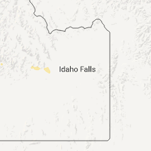
Idaho
| Local Time | Report Details |
|---|---|
| 11:07 PM UTC | 61 mile an hour wind gust at inl centrl facilit in butte county ID, 51.9 miles W of Idaho Falls, ID |
| 11:10 PM UTC | Lost river rest are in butte county ID, 48.8 miles W of Idaho Falls, ID |
| 11:15 PM UTC | Inl reactor tech sit in butte county ID, 47 miles W of Idaho Falls, ID |
| 11:15 PM UTC | Central inl facility wind senso in butte county ID, 47 miles W of Idaho Falls, ID |
| 11:20 PM UTC | Central inl facility weather instrument measured gust to 67 miles an hou in butte county ID, 45.6 miles W of Idaho Falls, ID |
| 11:25 PM UTC | 70 mile an hour wind gust at critical infrastucture complex in in butte county ID, 41.8 miles W of Idaho Falls, ID |
| 11:50 PM UTC | Big southern butte registered a wind gust to 66 miles an hou in butte county ID, 49.6 miles W of Idaho Falls, ID |
| 2:58 AM UTC | Quarter sized hail reported near Shoup, ID, 23.4 miles NW of Salmon, ID, received nickel to quarter sized hail from 858 to 911 mdt. |
New Hampshire
| Local Time | Report Details |
|---|---|
| 11:22 PM UTC | Quarter sized hail reported near Gorham, NH, 67 miles NW of Portland, ME, mount washington observatory observation. hail lasted for more than 30 minutes. |
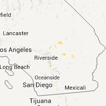
California
| Local Time | Report Details |
|---|---|
| 1:17 AM UTC | California highway patrol reported power lines were down at state route 58 at irwin roa in san bernardino county CA, 64.3 miles NNW of Yucca Valley, CA |
Wisconsin
| Local Time | Report Details |
|---|---|
| 8:00 AM UTC | Many trees down in the villag in douglas county WI, 33.1 miles SSE of Duluth, MN |
| 10:05 AM UTC | Storm damage reported in barron county WI, 79.1 miles ENE of Minneapolis, MN |
| 11:28 AM UTC | Trees down in several spots along hwy a from solon springs to co rd b in douglas county WI, 33.1 miles SSE of Duluth, MN |
Connect with Interactive Hail Maps