

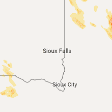
Hail Map for Sunday, July 9, 2017

Number of Impacted Households on 7/9/2017
0
Impacted by 1" or Larger Hail
0
Impacted by 1.75" or Larger Hail
0
Impacted by 2.5" or Larger Hail
Square Miles of Populated Area Impacted on 7/9/2017
0
Impacted by 1" or Larger Hail
0
Impacted by 1.75" or Larger Hail
0
Impacted by 2.5" or Larger Hail


Cities Most Affected by Hail Storms of 7/9/2017
| Hail Size | Demographics of Zip Codes Affected | ||||||
|---|---|---|---|---|---|---|---|
| City | Count | Average | Largest | Pop Density | House Value | Income | Age |
| Winthrop, MN | 4 | 3.00 | 4.00 | 13 | $74k | $36.1k | 43.7 |
| Lafayette, MN | 3 | 3.17 | 4.00 | 12 | $74k | $40.2k | 40.8 |
| Montevideo, MN | 4 | 1.81 | 2.00 | 30 | $67k | $34.9k | 42.7 |
| Appleton, MN | 2 | 1.88 | 2.00 | 11 | $47k | $31.5k | 48.7 |
| New Ulm, MN | 2 | 1.75 | 1.75 | 81 | $92k | $42.3k | 43.0 |
| Gibbon, MN | 1 | 2.50 | 2.50 | 10 | $58k | $37.1k | 45.3 |
| Onamia, MN | 1 | 2.00 | 2.00 | 19 | $82k | $30.8k | 40.0 |
| Cottonwood, MN | 1 | 1.75 | 1.75 | 13 | $84k | $42.1k | 39.1 |
| Clarkfield, MN | 1 | 1.75 | 1.75 | 9 | $44k | $37.5k | 44.7 |
| Benson, MN | 1 | 1.75 | 1.75 | 22 | $65k | $34.6k | 43.7 |
| Klemme, IA | 1 | 1.75 | 1.75 | 13 | $38k | $35.6k | 41.2 |
| Pierz, MN | 1 | 1.75 | 1.75 | 19 | $85k | $37.1k | 38.6 |
| Marshall, MN | 1 | 1.75 | 1.75 | 78 | $94k | $40.3k | 30.8 |
| Watson, MN | 1 | 1.75 | 1.75 | 11 | $38k | $42.0k | 41.0 |
Hail and Wind Damage Spotted on 7/9/2017
Filter by Report Type:Hail ReportsWind Reports
States Impacted
California, Oregon, Wyoming, Louisiana, Texas, Alabama, South Carolina, South Dakota, Georgia, Nebraska, Montana, Minnesota, Wisconsin, IowaCalifornia
| Local Time | Report Details |
|---|---|
| 8:16 AM PDT | Mesonet station hsgc1... highland springs. outflow from a convective complex over northwest mexic in riverside county CA, 35 miles WSW of Yucca Valley, CA |
Oregon
| Local Time | Report Details |
|---|---|
| 12:01 PM MDT | Report from facebook about an russian olive tree that was downed by outflow winds from thunderstorms to the southwest. the tree had a 2 part trunk... with the larger on in malheur county OR, 44.9 miles WNW of Boise, ID |
Wyoming
| Local Time | Report Details |
|---|---|
| 1:22 PM MDT | Storm damage reported in natrona county WY, 1.4 miles S of Casper, WY |
| 5:25 PM MDT | Greybull airpor in big horn county WY, 89.7 miles SSE of Billings, MT |
Louisiana
| Local Time | Report Details |
|---|---|
| 2:25 PM CDT | Several trees and power lines reported down in st. rose in st. charles parish. event time estimated by rada in st. charles county LA, 13.9 miles W of New Orleans, LA |
Texas
| Local Time | Report Details |
|---|---|
| 3:00 PM CDT | Spotter reported wind gust around 50 k in henderson county TX, 69.8 miles NW of Lufkin, TX |
| 3:11 PM CDT | Tree down on cr 381 off of 38 in smith county TX, 78.3 miles NNW of Lufkin, TX |
| 3:15 PM CDT | Tree down on cr 381 off of 38 in smith county TX, 78.3 miles NNW of Lufkin, TX |
| 3:40 PM CDT | Delayed report---roof damage to a couple of homes west and southwest of the city of corsicana. time estimated via rada in navarro county TX, 50.5 miles SSE of Dallas, TX |
| 4:30 PM CDT | Quarter sized hail reported near Weatherford, TX, 59.7 miles W of Dallas, TX, storm spotter reported hail up to quarter size and wind gust up to 40 mph. around 11 miles south of weatherford |
| 4:30 PM CDT | Multiple trees down in the corbet are in navarro county TX, 54.5 miles SSE of Dallas, TX |
| 5:35 PM CDT | Power lines and trees down in brownwood in brown county TX, 67.4 miles SE of Abilene, TX |
| 6:23 PM CDT | Multiple trees down in the tanglewood area (just west of tcu) in tarrant county TX, 31.8 miles W of Dallas, TX |
| 6:23 PM CDT | Multiple trees down in the tanglewood area (just west of tcu) in tarrant county TX, 31.8 miles W of Dallas, TX |
| 6:25 PM CDT | Delayed report: multiple trees damage sw fort worth... near benbroo in tarrant county TX, 38.7 miles W of Dallas, TX |
| 6:48 PM CDT | Quarter sized hail reported near Little Elm, TX, 27.6 miles NNW of Dallas, TX, fm 423 and panther creek parkway |
Alabama
| Local Time | Report Details |
|---|---|
| 3:45 PM CDT | 2 foot diameter tree fell across old pascagoula rd blocking one lane of traffic in mobile county AL, 11 miles SW of Mobile, AL |
South Carolina
| Local Time | Report Details |
|---|---|
| 5:33 PM EDT | Tree down on power line on buttermilk roa in bamberg county SC, 57.6 miles W of Charleston, SC |
South Dakota
| Local Time | Report Details |
|---|---|
| 4:40 PM CDT | Quarter sized hail reported near Platte, SD, 64.5 miles N of Oneill, NE, time estimated from radar. |
| 5:52 PM CDT | Cwop station e729 in gregory county SD, 40.9 miles NNW of Oneill, NE |
| 5:55 PM CDT | 4 to 6 inch diameter tree branches dow in gregory county SD, 40.6 miles NNW of Oneill, NE |
| 6:05 PM CDT | Grain bin destroyed. doors torn off two outbuilding in gregory county SD, 41.1 miles NNW of Oneill, NE |
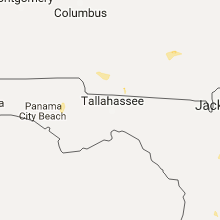
Georgia
| Local Time | Report Details |
|---|---|
| 6:05 PM EDT | Two trees down near glenwood and bluebird in thomas county GA, 34 miles NNE of Tallahassee, FL |
| 6:05 PM EDT | Report of tree down on cairo rd near hwy 84 in thomas county GA, 33.3 miles NNE of Tallahassee, FL |
Nebraska
| Local Time | Report Details |
|---|---|
| 6:08 PM CDT | Storm damage reported in boyd county NE, 32.9 miles NNW of Oneill, NE |
| 6:22 PM CDT | Large tree branch dow in boyd county NE, 26.8 miles N of Oneill, NE |
| 7:32 PM CDT | Storm damage reported in holt county NE, 0.2 miles NNW of Oneill, NE |
Montana
| Local Time | Report Details |
|---|---|
| 6:33 PM MDT | Trained spotter reported an estimated wind gusts over 60 mp in lewis and clark county MT, 72.7 miles SW of Great Falls, MT |
Minnesota
| Local Time | Report Details |
|---|---|
| 8:15 PM CDT | Half Dollar sized hail reported near Appleton, MN, 31.3 miles NW of Montevideo, MN |
| 8:17 PM CDT | Golf Ball sized hail reported near Appleton, MN, 31 miles NW of Montevideo, MN |
| 8:21 PM CDT | Hen Egg sized hail reported near Onamia, MN, 77.7 miles NNW of Minneapolis, MN |
| 8:34 PM CDT | Quarter sized hail reported near Stewart, MN, 60.7 miles WSW of Minneapolis, MN |
| 8:35 PM CDT | Golf Ball sized hail reported near Pierz, MN, 74 miles NNW of Minneapolis, MN |
| 8:36 PM CDT | Quarter sized hail reported near Ortonville, MN, 38.4 miles NW of Montevideo, MN |
| 8:44 PM CDT | Quarter sized hail reported near Brownton, MN, 58.8 miles WSW of Minneapolis, MN |
| 8:45 PM CDT | Hen Egg sized hail reported near Appleton, MN, 22.7 miles NW of Montevideo, MN |
| 8:50 PM CDT | Golf Ball sized hail reported near Benson, MN, 25.4 miles NNE of Montevideo, MN |
| 8:50 PM CDT | Quarter sized hail reported near Prior Lake, MN, 20.7 miles SSW of Minneapolis, MN |
| 8:50 PM CDT | Half Dollar sized hail reported near Prior Lake, MN, 20.3 miles SSW of Minneapolis, MN |
| 8:55 PM CDT | Tennis Ball sized hail reported near Gibbon, MN, 65.7 miles ESE of Montevideo, MN |
| 8:55 PM CDT | Baseball sized hail reported near Winthrop, MN, 62.2 miles WSW of Minneapolis, MN |
| 8:56 PM CDT | Quarter sized hail reported near Watson, MN, 8.6 miles NW of Montevideo, MN |
| 9:00 PM CDT | Trees down in credit river township. photo from social media. time estimated from rada in scott county MN, 19.7 miles SSW of Minneapolis, MN |
| 9:02 PM CDT | Grapefruit sized hail reported near Winthrop, MN, 63.4 miles WSW of Minneapolis, MN, report from social media. time estimated from radar. |
| 9:02 PM CDT | Golf Ball sized hail reported near Watson, MN, 8.6 miles NW of Montevideo, MN |
| 9:05 PM CDT | Quarter sized hail reported near Correll, MN, 27 miles NW of Montevideo, MN |
| 9:08 PM CDT | Quarter sized hail reported near Saint Paul, MN, 17.3 miles S of Minneapolis, MN |
| 9:10 PM CDT | 12" diameter tree snapped near bas in sibley county MN, 64.9 miles WSW of Minneapolis, MN |
| 9:10 PM CDT | Baseball sized hail reported near Winthrop, MN, 64.9 miles WSW of Minneapolis, MN |
| 9:10 PM CDT | Quarter sized hail reported near Lakeville, MN, 20.2 miles S of Minneapolis, MN |
| 9:11 PM CDT | Hen Egg sized hail reported near Montevideo, MN, 5.6 miles NW of Montevideo, MN |
| 9:12 PM CDT | Quarter sized hail reported near Farmington, MN, 20.3 miles S of Minneapolis, MN |
| 9:12 PM CDT | Quarter sized hail reported near Lakeville, MN, 20.7 miles S of Minneapolis, MN |
| 9:13 PM CDT | Tennis Ball sized hail reported near Winthrop, MN, 61.8 miles WSW of Minneapolis, MN |
| 9:15 PM CDT | Ping Pong Ball sized hail reported near Farmington, MN, 24.2 miles SSE of Minneapolis, MN |
| 9:15 PM CDT | Baseball sized hail reported near Lafayette, MN, 66.7 miles WSW of Minneapolis, MN |
| 9:15 PM CDT | Multiple trees of 12" to 18" in diamter snapped. numerous powerlines dow in nicollet county MN, 66.7 miles WSW of Minneapolis, MN |
| 9:15 PM CDT | Quarter sized hail reported near Saint Paul, MN, 16.7 miles S of Minneapolis, MN |
| 9:15 PM CDT | Grapefruit sized hail reported near Lafayette, MN, 66.4 miles WSW of Minneapolis, MN |
| 9:20 PM CDT | Golf Ball sized hail reported near Montevideo, MN, 0.9 miles E of Montevideo, MN |
| 9:20 PM CDT | Quarter sized hail reported near Lakeville, MN, 19.2 miles SSE of Minneapolis, MN |
| 9:20 PM CDT | Golf Ball sized hail reported near Montevideo, MN, 6.7 miles SW of Montevideo, MN |
| 9:20 PM CDT | Golf Ball sized hail reported near Clarkfield, MN, 6.7 miles SSW of Montevideo, MN |
| 9:20 PM CDT | Quarter sized hail reported near Lakeville, MN, 20 miles S of Minneapolis, MN |
| 9:23 PM CDT | Golf Ball sized hail reported near Montevideo, MN, 1.1 miles W of Montevideo, MN |
| 9:25 PM CDT | Quarter sized hail reported near Saint Paul, MN, 5.8 miles SE of Minneapolis, MN |
| 9:30 PM CDT | Golf Ball sized hail reported near New Ulm, MN, 68.9 miles SW of Minneapolis, MN, picture from social media. |
| 9:30 PM CDT | Golf Ball sized hail reported near New Ulm, MN, 72.4 miles SW of Minneapolis, MN |
| 9:32 PM CDT | Quarter sized hail reported near Saint Paul, MN, 9.9 miles ESE of Minneapolis, MN |
| 9:34 PM CDT | Quarter sized hail reported near Saint Paul, MN, 8.8 miles ESE of Minneapolis, MN |
| 9:38 PM CDT | Ping Pong Ball sized hail reported near New Ulm, MN, 68.5 miles SW of Minneapolis, MN |
| 9:42 PM CDT | Roof of a hog barn blown off from a possible tornado. time estimated from rada in nicollet county MN, 69.9 miles SW of Minneapolis, MN |
| 9:45 PM CDT | Quarter sized hail reported near Lake Crystal, MN, 74.2 miles SW of Minneapolis, MN |
| 9:53 PM CDT | Damage to roof of a home. photo from social medi in le sueur county MN, 54.5 miles SSW of Minneapolis, MN |
| 10:07 PM CDT | Quarter sized hail reported near Nicollet, MN, 66.4 miles SW of Minneapolis, MN |
| 10:08 PM CDT | Golf Ball sized hail reported near Marshall, MN, 29.2 miles S of Montevideo, MN |
| 10:16 PM CDT | Golf Ball sized hail reported near Cottonwood, MN, 27.7 miles S of Montevideo, MN, report via social media. |
| 10:30 PM CDT | Baseball sized hail reported near Lafayette, MN, 66.7 miles WSW of Minneapolis, MN |
| 11:10 PM CDT | Law enforcement reports trees & power lines dow in blue earth county MN, 73.8 miles NW of Mason City, IA |
Wisconsin
| Local Time | Report Details |
|---|---|
| 12:00 AM CDT | Half Dollar sized hail reported near Arena, WI, 27.1 miles WNW of Madison, WI, relayed via media. |
| 12:01 AM CDT | Quarter sized hail reported near Arena, WI, 27.1 miles WNW of Madison, WI |
| 2:04 AM CDT | Quarter sized hail reported near Palmyra, WI, 42.5 miles ESE of Madison, WI, relayed via social media. |
Iowa
| Local Time | Report Details |
|---|---|
| 12:05 AM CDT | Law enforcement reports a tree blown down on a house in kensett. delayed report. time estimated from rada in worth county IA, 14 miles N of Mason City, IA |
| 12:10 AM CDT | Worth county emergency manager reports trees uprooted and grain bin blown down in hanlontown. delayed report. time estimated from rada in worth county IA, 12.9 miles NW of Mason City, IA |
| 1:25 AM CDT | Law enforcement reports trees and power lines down at crystal lake. delayed report. time estimated from rada in hancock county IA, 30.2 miles W of Mason City, IA |
| 1:28 AM CDT | Law enforcement reports power lines down on the northwest side of britt. delayed report. time estimated from rada in hancock county IA, 30.5 miles W of Mason City, IA |
| 1:48 AM CDT | Golf Ball sized hail reported near Klemme, IA, 22.3 miles WSW of Mason City, IA, time and location estimated from radar. |
| 2:13 AM CDT | Law enforcement reports power lines down in latimer. delayed report. time estimated from rada in franklin county IA, 28 miles SSW of Mason City, IA |
| 3:19 AM CDT | Law enforcement reports power lines blown down onto a semi trailer. delayed report. time estimated from rada in tama county IA, 44.5 miles WNW of Cedar Rapids, IA |
| 4:56 AM CDT | Power lines down in the trees on hwy 61 north of 260th st. dispatch center power out and on portable backup in des moines county IA, 52.4 miles NE of Kahoka, MO |
| 5:08 AM CDT | Quarter sized hail reported near Washington, IA, 39.8 miles S of Cedar Rapids, IA |
Connect with Interactive Hail Maps