

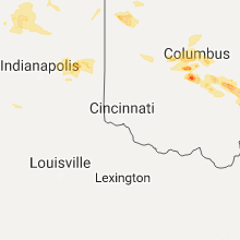
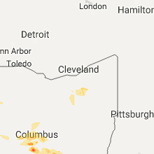
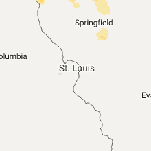
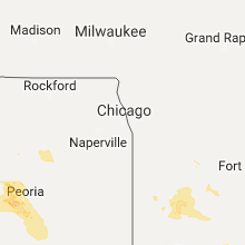
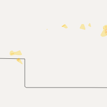
Hail Map for Monday, July 10, 2017

Number of Impacted Households on 7/10/2017
0
Impacted by 1" or Larger Hail
0
Impacted by 1.75" or Larger Hail
0
Impacted by 2.5" or Larger Hail
Square Miles of Populated Area Impacted on 7/10/2017
0
Impacted by 1" or Larger Hail
0
Impacted by 1.75" or Larger Hail
0
Impacted by 2.5" or Larger Hail


Cities Most Affected by Hail Storms of 7/10/2017
| Hail Size | Demographics of Zip Codes Affected | ||||||
|---|---|---|---|---|---|---|---|
| City | Count | Average | Largest | Pop Density | House Value | Income | Age |
| Fairview, IL | 2 | 2.13 | 2.50 | 8 | $61k | $35.8k | 40.0 |
| Mendon, OH | 1 | 2.50 | 2.50 | 32 | $67k | $35.5k | 41.9 |
| Hanna City, IL | 1 | 1.75 | 1.75 | 63 | $93k | $50.9k | 44.9 |
| Farmington, IL | 1 | 1.75 | 1.75 | 58 | $67k | $36.7k | 40.8 |
| Albany, MO | 1 | 1.75 | 1.75 | 17 | $56k | $27.0k | 44.5 |
| Bowman, ND | 1 | 1.75 | 1.75 | 2 | $59k | $32.9k | 46.8 |
Hail and Wind Damage Spotted on 7/10/2017
Filter by Report Type:Hail ReportsWind Reports
States Impacted
Indiana, Ohio, South Carolina, Georgia, Pennsylvania, Montana, Florida, Nevada, North Carolina, West Virginia, Illinois, Missouri, North Dakota, Nebraska, Arizona, IowaIndiana
| Local Time | Report Details |
|---|---|
| 8:30 AM EDT | Large limb down on top of vehicl in st. joseph county IN, 72.5 miles NW of Fort Wayne, IN |
| 9:03 AM EDT | Tree limb on vehicle at hardees. dime sized hail also reporte in huntington county IN, 24.7 miles WSW of Fort Wayne, IN |
| 9:16 AM EDT | 2 tree limbs dow in marshall county IN, 63.8 miles W of Fort Wayne, IN |
| 7:55 PM EDT | Trees dow in adams county IN, 18.9 miles SSE of Fort Wayne, IN |
| 8:00 PM EDT | Tree damag in adams county IN, 22.1 miles S of Fort Wayne, IN |
| 1:42 AM EDT | Ping Pong Ball sized hail reported near New Castle, IN, 42.5 miles ENE of Indianapolis, IN, estimated 70 mph winds. power out. fence blown down. |
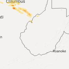
Ohio
| Local Time | Report Details |
|---|---|
| 12:40 PM EDT | Numerous streets flooded in and around lima. some streets are being closed off by polic in allen county OH, 56.7 miles ESE of Fort Wayne, IN |
| 3:00 PM EDT | Quarter sized hail reported near Hilliard, OH, 9 miles NW of Columbus, OH |
| 3:05 PM EDT | A couple of trees down in genoa and porter townships. time estimated from rada in delaware county OH, 21.3 miles NNE of Columbus, OH |
| 3:07 PM EDT | Small trees coming down... heavy rain... pea-sized hai in franklin county OH, 7 miles NW of Columbus, OH |
| 3:08 PM EDT | 6 inch diameter tree fell onto su in franklin county OH, 10.2 miles NW of Columbus, OH |
| 3:08 PM EDT | One large tree down on davidson road. photo verified. time estimated from rada in franklin county OH, 9.5 miles NW of Columbus, OH |
| 3:11 PM EDT | Quarter sized hail reported near Hilliard, OH, 11 miles WNW of Columbus, OH |
| 3:12 PM EDT | Trees down in columbiana county OH, 53.2 miles WNW of Pittsburgh, PA |
| 3:13 PM EDT | Quarter sized hail reported near Hilliard, OH, 8.7 miles WNW of Columbus, OH |
| 3:20 PM EDT | 18 inch diameter branch down on osu campus. photo verified. time estimated from rada in franklin county OH, 3.6 miles NNW of Columbus, OH |
| 3:20 PM EDT | Quarter sized hail reported near Hilliard, OH, 9.1 miles WNW of Columbus, OH, photo verified. |
| 3:35 PM EDT | 6 inch branch down on 4th avenue and north high street. time estimated from rada in franklin county OH, 2 miles N of Columbus, OH |
| 3:45 PM EDT | Trees down on dry creek road. time estimated from rada in licking county OH, 28.3 miles ENE of Columbus, OH |
| 3:45 PM EDT | Trees dwon on welsh hills road in licking county OH, 29.3 miles ENE of Columbus, OH |
| 4:20 PM EDT | Numerous trees and a few power lines down in muskingum county OH, 54.6 miles E of Columbus, OH |
| 4:29 PM EDT | Ping Pong Ball sized hail reported near Lancaster, OH, 27.2 miles SE of Columbus, OH |
| 4:29 PM EDT | Quarter sized hail reported near Lancaster, OH, 26.7 miles SE of Columbus, OH, photo verified. |
| 4:45 PM EDT | Trees down at 312 and 664 intersection. time estimated from rada in fairfield county OH, 36.2 miles ESE of Columbus, OH |
| 4:49 PM EDT | Trees down in guernsey county OH, 75.1 miles E of Columbus, OH |
| 4:50 PM EDT | Trees down in guernsey county OH, 77.7 miles E of Columbus, OH |
| 4:50 PM EDT | Half Dollar sized hail reported near Commercial Point, OH, 13.6 miles SSW of Columbus, OH, photo verified. |
| 4:55 PM EDT | Trees down in guernsey county OH, 82 miles E of Columbus, OH |
| 5:25 PM EDT | Numerous trees and power lines down in murray city. no power or communications. time estimated from rada in hocking county OH, 54.2 miles SE of Columbus, OH |
| 5:40 PM EDT | Quarter sized hail reported near Millfield, OH, 57.6 miles SE of Columbus, OH, cocorahs report of one inch hail that laster for five minutes. |
| 5:50 PM EDT | Multiple homes with roof damag in athens county OH, 57.2 miles SE of Columbus, OH |
| 5:52 PM EDT | One large tree and numerous large limbs down at the intersection of cherry bottom road and wyandotte drive. time estimated from rada in franklin county OH, 9.6 miles NE of Columbus, OH |
| 6:39 PM EDT | Multiple trees and power lines down in little hocking reported via social media. time estimated by rada in washington county OH, 62.8 miles N of Charleston, WV |
| 6:46 PM EDT | Several trees uprooted in reno area via social media report. time estimated by rada in washington county OH, 71.5 miles N of Charleston, WV |
| 10:31 PM EDT | Tennis Ball sized hail reported near Mendon, OH, 41.3 miles SE of Fort Wayne, IN |
| 10:45 PM EDT | Quarter sized hail reported near Spencerville, OH, 46.6 miles ESE of Fort Wayne, IN, delayed report. hail images relayed via lima media. pictures look slightly larger than quarter sized. |
| 11:25 PM EDT | Multiple trees and power lines down in little hocking reported via social media. time estimated by rada in washington county OH, 62.8 miles N of Charleston, WV |
| 11:38 PM EDT | Several trees uprooted in reno area via social media report. time estimated by rada in washington county OH, 71.5 miles N of Charleston, WV |
| 1:24 AM EDT | 1 tree limb knocked down in hardin county OH, 57.9 miles NNW of Columbus, OH |
South Carolina
| Local Time | Report Details |
|---|---|
| 2:15 PM EDT | Photos of tree limbs down averaging 5 to 6 inches in diameter with additional leaf damage note in charleston county SC, 25.7 miles S of Charleston, SC |
| 5:05 PM EDT | Tree reported down on tillman road at tarboro road. time estimated based on rada in jasper county SC, 27.2 miles N of Savannah, GA |
| 5:05 PM EDT | South carolina highway patrol reported a tree down in the road near the intersection of smiths crossing and catfish circl in jasper county SC, 27.1 miles N of Savannah, GA |
| 5:23 PM EDT | South carolina highway patrol reported a tree down in the road near the intersection of highway 321 and locked roa in jasper county SC, 22.7 miles N of Savannah, GA |
Georgia
| Local Time | Report Details |
|---|---|
| 3:45 PM EDT | Powerlines down in ocilla in irwin county GA, 24.5 miles WNW of Douglas, GA |
| 5:25 PM EDT | Half a dozen trees are reportedly blown over within the town of greensboro... some blown down over powerlines in greene county GA, 69.9 miles W of Augusta, GA |
| 5:25 PM EDT | Home depot near greensboro had outdoor overhead shelters flipped over outside the stor in greene county GA, 69.6 miles ESE of Atlanta, GA |
Pennsylvania
| Local Time | Report Details |
|---|---|
| 4:05 PM EDT | Several trees down on little creek and hartmon roads in butler county PA, 25.2 miles N of Pittsburgh, PA |
| 4:05 PM EDT | Tree down in butler county PA, 30.7 miles NNW of Pittsburgh, PA |
| 4:10 PM EDT | Two trees down in butler county PA, 23.1 miles N of Pittsburgh, PA |
Montana
| Local Time | Report Details |
|---|---|
| 2:15 PM MDT | Quarter sized hail reported near Whitehall, MT, 58.2 miles W of Bozeman, MT |
| 2:31 PM MDT | Ping Pong Ball sized hail reported near Livingston, MT, 26.3 miles ESE of Bozeman, MT, hail size ranged from pea size to ping pong ball size hail over 30 minute period. observer station is approx 5000 ft elevation |
| 2:52 PM MDT | Judith peak raws reported a maximum wind gust of 68 mph in fergus county MT, 94.4 miles SSE of Havre, MT |
| 3:06 PM MDT | Quarter sized hail reported near Glen, MT, 61.5 miles ENE of Salmon, ID, quarter sized hail reported just west of glen on interstate 15 at 306 pm. |
| 3:29 PM MDT | Half Dollar sized hail reported near Whitehall, MT, 67.5 miles W of Bozeman, MT, resident on z bar t road reported hail smaller than golf balls but larger than quarters. damages included tree branches down and dents over the surface of camper. wind |
| 3:41 PM MDT | Dry blood creek blm raws station reported a 63 mph wind gus in petroleum county MT, 100.8 miles N of Billings, MT |
| 3:45 PM MDT | Malta 35 south montana dept of highways weather station reported a 59 mph wind gus in phillips county MT, 74.2 miles ESE of Havre, MT |
| 4:08 PM MDT | South sawmill creek blm raws station reports a 68 mph wind gus in garfield county MT, 60.4 miles SW of Glasgow, MT |
| 4:30 PM MDT | Quarter sized hail reported near Butte, MT, 74.9 miles WNW of Bozeman, MT, over one inch hail occurring at time of call from trained spotter. |
| 4:42 PM MDT | Jordan nws asos reported 60 mph wind gust in garfield county MT, 62.2 miles SSW of Glasgow, MT |
| 4:44 PM MDT | King coulee blm raws station reported a 66 mph wind gus in valley county MT, 32.6 miles SSW of Glasgow, MT |
| 4:45 PM MDT | Storm damage reported in treasure county MT, 63.2 miles ENE of Billings, MT |
| 4:51 PM MDT | Storm damage reported in rosebud county MT, 41.4 miles W of Miles City, MT |
| 4:54 PM MDT | Storm damage reported in rosebud county MT, 41.4 miles W of Miles City, MT |
| 4:56 PM MDT | Storm damage reported in rosebud county MT, 40.4 miles WSW of Miles City, MT |
| 5:00 PM MDT | Strong wind gusts to 60 mph sustained around 40 mph. dust reducing visibility to less than 1/2 mile at time in garfield county MT, 50.9 miles SSE of Glasgow, MT |
| 5:10 PM MDT | 3/4 inch diameter tree branches dow in valley county MT, 2 miles W of Glasgow, MT |
| 5:22 PM MDT | Glasgow international airport asos reported a 59 mph wind gus in valley county MT, 1 miles N of Glasgow, MT |
| 5:27 PM MDT | West glasgow mesonet station reported 56 mph sustained wind with a gust to 70 mp in valley county MT, 2 miles W of Glasgow, MT |
| 5:36 PM MDT | Storm damage reported in custer county MT, 2.5 miles NW of Miles City, MT |
| 5:41 PM MDT | Strong winds brought down trees and power lines are down and have caused fires across miles city mt in custer county MT, 0.2 miles NNW of Miles City, MT |
| 5:44 PM MDT | Wind gust measured at 65mph. king coulee raw in valley county MT, 32.6 miles SSW of Glasgow, MT |
| 5:53 PM MDT | Created severe dust storm in custer county MT, 13.1 miles NNE of Miles City, MT |
| 6:00 PM MDT | Storm damage reported in rosebud county MT, 35.4 miles NW of Miles City, MT |
| 6:15 PM MDT | Storm damage reported in rosebud county MT, 35.4 miles NW of Miles City, MT |
| 6:29 PM MDT | Power outage in custer county MT, 36.8 miles SE of Miles City, MT |
| 7:45 PM MDT | Quarter sized hail reported near Wibaux, MT, 84.4 miles ENE of Miles City, MT, quarter size hail on montana highway 7. |
| 7:45 PM MDT | Motorist estimated 60 mph wind gust on montana highway in wibaux county MT, 84.4 miles ENE of Miles City, MT |
| 7:45 PM MDT | Public reports 60 mph wind gust in the town of fairview... m in richland county MT, 28.1 miles SW of Williston, ND |
Florida
| Local Time | Report Details |
|---|---|
| 4:18 PM EDT | Half Dollar sized hail reported near Tampa, FL, 44.8 miles NNE of Bradenton, FL, viewer photo sent to media partner suggests 1 to 1.25 inch hail. time estimated by radar. |
| 5:32 PM EDT | 51 knots measured at the middle tampa bay ports sit in gmz830 county FL, 17.6 miles N of Bradenton, FL |
| 5:42 PM EDT | Quarter sized hail reported near Palatka, FL, 46.9 miles S of Jacksonville, FL, gas station employee reported quarter size hail. |
| 5:45 PM EDT | Large tree down and numerous branches near interstate 75 and state road 5 in pasco county FL, 50 miles NNE of Bradenton, FL |
| 5:45 PM EDT | Emergency manager reports multiple trees down over road in putnam county FL, 46.9 miles S of Jacksonville, FL |
Nevada
| Local Time | Report Details |
|---|---|
| 1:55 PM PDT | Reported at boulder city municipal airport at 155 p in clark county NV, 21.9 miles SE of Las Vegas, NV |
| 5:37 PM PDT | Kins asos measured 62kt gus in clark county NV, 41.3 miles NW of Las Vegas, NV |
North Carolina
| Local Time | Report Details |
|---|---|
| 5:09 PM EDT | Report of a tree down on chason rd just north of lumber bridge. time estimated by rada in robeson county NC, 64.2 miles SSW of Raleigh, NC |
| 5:57 PM EDT | Report of a tree down at the 1400 block of ivey rd near regan church rd. time estimated by rada in robeson county NC, 63.5 miles WNW of Wilmington, NC |
West Virginia
| Local Time | Report Details |
|---|---|
| 6:37 PM EDT | Large tree down along route 18 near tyler/doddridge county line. via social media... time estimated from rada in tyler county WV, 61 miles WNW of Elkins, WV |
| 6:45 PM EDT | Large tree and lines down along rock run road. via social media... time estimated from rada in doddridge county WV, 55.5 miles WNW of Elkins, WV |
| 6:47 PM EDT | Several trees down along route 23 west of center point. via social media... time estimated from rada in doddridge county WV, 54.3 miles NW of Elkins, WV |
| 6:50 PM EDT | Trees down in parkersburg... some power outages. time estimated by rada in wood county WV, 62.9 miles N of Charleston, WV |
| 7:03 PM EDT | Tree down in miletus. time estimated by rada in doddridge county WV, 45.3 miles WNW of Elkins, WV |
| 7:04 PM EDT | Multiple trees down in reynoldsville... one fell onto a car. time estimated by rada in harrison county WV, 40.8 miles NW of Elkins, WV |
| 7:07 PM EDT | Large chestnut tree blown down. time estimated by rada in harrison county WV, 41.6 miles NW of Elkins, WV |
| 7:18 PM EDT | Multiple trees uprooted along matson run road between shinnston and pine bluff. report via social media... time estimated by rada in harrison county WV, 41.5 miles NW of Elkins, WV |
| 7:19 PM EDT | Tree and lines down along corbin branch road. via social media... time estimated from rada in harrison county WV, 33.6 miles NW of Elkins, WV |
| 11:35 PM EDT | Trees down in parkersburg... some power outages. time estimated by rada in wood county WV, 62.9 miles N of Charleston, WV |
| 11:47 PM EDT | Tree limbs down in the road in jackson's mill. reported via social media... time estimated by rada in lewis county WV, 35.8 miles WNW of Elkins, WV |
| 11:53 PM EDT | Multiple trees uprooted along matson run road between shinnston and pine bluff. report via social media... time estimated by rada in harrison county WV, 41.5 miles NW of Elkins, WV |
Illinois
| Local Time | Report Details |
|---|---|
| 6:21 PM CDT | Quarter sized hail reported near Brimfield, IL, 18.4 miles NW of Peoria, IL |
| 6:38 PM CDT | Quarter sized hail reported near Brimfield, IL, 15.5 miles WNW of Peoria, IL |
| 6:54 PM CDT | Golf Ball sized hail reported near Hanna City, IL, 10.6 miles W of Peoria, IL |
| 6:57 PM CDT | Storm damage reported in peoria county IL, 10.6 miles W of Peoria, IL |
| 7:02 PM CDT | Quarter sized hail reported near Peoria, IL, 6.9 miles W of Peoria, IL |
| 7:09 PM CDT | Quarter sized hail reported near Hanna City, IL, 11 miles WSW of Peoria, IL |
| 7:15 PM CDT | Ping Pong Ball sized hail reported near London Mills, IL, 30.6 miles W of Peoria, IL |
| 7:20 PM CDT | Tennis Ball sized hail reported near Fairview, IL, 31.8 miles W of Peoria, IL, relayed by ema. time estimated. |
| 7:20 PM CDT | Golf Ball sized hail reported near Fairview, IL, 31.6 miles W of Peoria, IL, relayed by ema |
| 7:23 PM CDT | Quarter sized hail reported near Pekin, IL, 8.7 miles SSW of Peoria, IL |
| 7:23 PM CDT | Trees uprooted. time estimate in tazewell county IL, 7.7 miles S of Peoria, IL |
| 7:27 PM CDT | Golf Ball sized hail reported near Farmington, IL, 23.8 miles W of Peoria, IL |
| 8:01 PM CDT | 2 foot diameter tree fell on car in tazewell county IL, 13.7 miles SSW of Peoria, IL |
| 8:09 PM CDT | Trees and power poles down in bushnell... time estimated based on rada in mcdonough county IL, 49 miles WSW of Peoria, IL |
| 8:10 PM CDT | Two 15-20 inch diameter trees snapped on 400 block of 10th street... blocking road in logan county IL, 39.1 miles SSE of Peoria, IL |
| 8:14 PM CDT | At wfo ilx in logan county IL, 39.8 miles SSE of Peoria, IL |
| 8:14 PM CDT | Numerous power lines and poles down in town in logan county IL, 39.1 miles SSE of Peoria, IL |
| 8:15 PM CDT | Several trees down and two cars damaged from falling trees in logan county IL, 33.7 miles SSE of Peoria, IL |
| 8:23 PM CDT | Several power lines down... one large tree down... one large antique windmill blown down. time estimated based on rada in mcdonough county IL, 50 miles WSW of Peoria, IL |
| 8:35 PM CDT | Quarter sized hail reported near Arlington, IL, 53.9 miles NNE of Peoria, IL, time and location estimated by radar. |
| 8:35 PM CDT | Storm damage reported in logan county IL, 39.8 miles SSE of Peoria, IL |
| 8:37 PM CDT | Ping Pong Ball sized hail reported near Peru, IL, 50.7 miles NNE of Peoria, IL, ping pong ball size hail near shooting park road. |
| 8:45 PM CDT | Quarter sized hail reported near La Salle, IL, 52.8 miles NNE of Peoria, IL, quarter size hail on i-39 near exit 57. |
| 8:52 PM CDT | Quarter sized hail reported near La Salle, IL, 57.9 miles NNE of Peoria, IL, quarter size hail near i-39 at exit 66. |
| 10:04 PM CDT | Power lines down in sangamon county IL, 63 miles S of Peoria, IL |
| 10:25 PM CDT | 4 inch diameter tree limb blown down in sangamon county IL, 64.8 miles WNW of Mattoon, IL |
| 10:30 PM CDT | Large tree branch blown down on a garage. numerous tree limbs blown down in yar in christian county IL, 44.8 miles WNW of Mattoon, IL |
| 10:40 PM CDT | Trees blown down on several properties in rosamond. an awning blown dow in christian county IL, 42.5 miles W of Mattoon, IL |
| 10:55 PM CDT | *** 1 inj *** house was severely damaged. trees and power lines downe in montgomery county IL, 50 miles WSW of Mattoon, IL |
| 10:55 PM CDT | *** 1 inj *** the severely damaged sructure mentioned in a previous lsr was a trailer. the injury occurred at the trailer due to wind damage. numerous trees and power l in montgomery county IL, 50.5 miles WSW of Mattoon, IL |
Missouri
| Local Time | Report Details |
|---|---|
| 6:58 PM CDT | Quarter sized hail reported near Albany, MO, 81.2 miles N of Kansas City, MO, public reported quarter size hail east of albany along u.s. hwy 136. relayed per sheriff's dept. |
| 7:10 PM CDT | Golf Ball sized hail reported near Albany, MO, 82.7 miles N of Kansas City, MO, picture via twitter. |
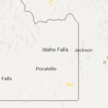
North Dakota
| Local Time | Report Details |
|---|---|
| 6:04 PM MDT | Quarter sized hail reported near Rhame, ND, 105.5 miles E of Miles City, MT, quarter size hail. relayed via social media. |
| 6:34 PM MDT | Golf Ball sized hail reported near Bowman, ND, 122.5 miles WSW of Bismarck, ND, lasted about 5 minutes. broke house windows and caused tree damage. time estimated from radar. |
Nebraska
| Local Time | Report Details |
|---|---|
| 7:55 PM MDT | Storm damage reported in deuel county NE, 71.6 miles NNE of Yuma, CO |
| 11:55 PM CDT | Quarter sized hail reported near Norfolk, NE, 69.6 miles ESE of Oneill, NE, wind driving hailstones into siding of home. |
| 12:04 AM CDT | Quarter sized hail reported near Norfolk, NE, 71 miles ESE of Oneill, NE |
Arizona
| Local Time | Report Details |
|---|---|
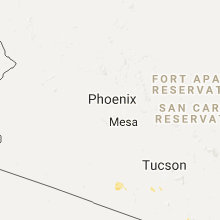
| 7:05 PM MST | House collapsed with 2 people inside due to thunderstorm wind... they were rescued uninjured. also several power lines down around sell in pima county AZ, 57.3 miles WSW of Tucson, AZ |
| 7:11 PM MST | Roofs blown off a couple of houses in the area in pima county AZ, 57.3 miles WSW of Tucson, AZ |
| 7:14 PM MST | Storm damage reported in pima county AZ, 58.6 miles WSW of Tucson, AZ |
| 10:30 PM MST | Palo verde trees blown down. estimated 4 inches diameter. radar estimated tim in pinal county AZ, 35.8 miles E of Phoenix, AZ |
Iowa
| Local Time | Report Details |
|---|---|
| 6:06 AM CDT | Limb down across the road in wellma in washington county IA, 36 miles SSW of Cedar Rapids, IA |
Connect with Interactive Hail Maps