

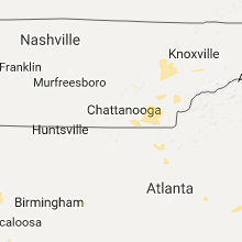
Hail Map for Saturday, July 8, 2017

Number of Impacted Households on 7/8/2017
0
Impacted by 1" or Larger Hail
0
Impacted by 1.75" or Larger Hail
0
Impacted by 2.5" or Larger Hail
Square Miles of Populated Area Impacted on 7/8/2017
0
Impacted by 1" or Larger Hail
0
Impacted by 1.75" or Larger Hail
0
Impacted by 2.5" or Larger Hail
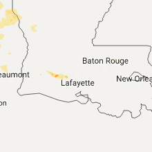


Cities Most Affected by Hail Storms of 7/8/2017
| Hail Size | Demographics of Zip Codes Affected | ||||||
|---|---|---|---|---|---|---|---|
| City | Count | Average | Largest | Pop Density | House Value | Income | Age |
| Loup City, NE | 1 | 2.75 | 2.75 | 6 | $41k | $26.5k | 49.3 |
| Hendersonville, NC | 1 | 1.75 | 1.75 | 309 | $111k | $32.8k | 41.3 |
Hail and Wind Damage Spotted on 7/8/2017
Filter by Report Type:Hail ReportsWind Reports
States Impacted
New York, Arkansas, Mississippi, New Hampshire, Maine, Tennessee, Massachusetts, Vermont, Texas, Alabama, North Carolina, South Carolina, Georgia, Nebraska, OklahomaNew York
| Local Time | Report Details |
|---|---|
| 8:12 AM EDT | Tree and wire dow in allegany county NY, 68.2 miles SSE of Buffalo, NY |
| 11:09 AM EDT | Tree limbs blocking roadway in albany county NY, 8 miles SSE of Schenectady, NY |
| 11:17 AM EDT | Downed tre in rensselaer county NY, 14.4 miles ESE of Schenectady, NY |
| 11:37 AM EDT | Downed tre in rensselaer county NY, 30.3 miles SE of Schenectady, NY |
| 1:25 PM EDT | Trees down on angier hill road in essex county NY, 17.5 miles SSW of Burlington, VT |
| 1:25 PM EDT | Small boats overturned just offshore near cannon point in essex county NY, 15.1 miles SSW of Burlington, VT |
| 1:25 PM EDT | Trees and power lines down on lila wa in essex county NY, 15.1 miles SSW of Burlington, VT |
| 5:15 PM EDT | One tree down on wire in dutchess county NY, 63.9 miles N of Brooklyn, NY |
Arkansas
| Local Time | Report Details |
|---|---|
| 8:32 AM CDT | Law enforcement is reporting a tree has fallen across a home in south el dorado. no one was home at the time. keld reported a peak gust to 32 mph at 8:32 a in union county AR, 52.1 miles NW of Bastrop, LA |
Mississippi
| Local Time | Report Details |
|---|---|
| 9:28 AM CDT | Downed power line on wiley s in humphreys county MS, 62.9 miles NNW of Jackson, MS |
New Hampshire
| Local Time | Report Details |
|---|---|
| 12:51 PM EDT | Tree down on wires in cheshire county NH, 82 miles NNW of Providence, RI |
| 12:55 PM EDT | Trees and wires down on antrim road. time estimated from rada in hillsborough county NH, 84.7 miles NNW of Providence, RI |
| 12:55 PM EDT | Trees and wires down on forest road near route 202. time estimated from rada in hillsborough county NH, 83.3 miles NNW of Providence, RI |
| 12:59 PM EDT | Trees and wires down on rt123 in hillsborough county NH, 84.3 miles NNW of Providence, RI |
| 12:59 PM EDT | Tree and wires down in hillsborough county NH, 75 miles NNW of Providence, RI |
| 1:20 PM EDT | Tree and wires down on new boston roa in hillsborough county NH, 82.8 miles NNW of Providence, RI |
| 1:20 PM EDT | Trees and wires down on dennison pond road in hillsborough county NH, 83 miles NNW of Providence, RI |
| 1:30 PM EDT | On bodwell rd... around 30 trees down facing the same direction in hillsborough county NH, 75.9 miles SW of Portland, ME |
| 1:30 PM EDT | Tree down in a backyard in hillsborough county NH, 75.9 miles SW of Portland, ME |
| 1:30 PM EDT | Multiple trees down on rt 1 in hillsborough county NH, 81.1 miles N of Providence, RI |
| 1:35 PM EDT | Trees down in rockingham county NH, 71.5 miles SW of Portland, ME |
| 1:40 PM EDT | Trees down in rockingham county NH, 65.2 miles SW of Portland, ME |
| 1:40 PM EDT | Trees down in rockingham county NH, 69.9 miles SW of Portland, ME |
| 1:45 PM EDT | Tree down on route 102. time estimated from rada in rockingham county NH, 71.6 miles SW of Portland, ME |
| 1:50 PM EDT | Multiple trees down in hillsborough county NH, 78.8 miles WSW of Portland, ME |
| 1:55 PM EDT | Trees down in rockingham county NH, 67.6 miles SW of Portland, ME |
| 2:05 PM EDT | Rt 111a closed tree down in rockingham county NH, 66.5 miles SW of Portland, ME |
Maine
| Local Time | Report Details |
|---|---|
| 12:56 PM EDT | Large limbs downe in somerset county ME, 57.3 miles WNW of Bangor, ME |
| 2:06 PM EDT | Trees down on road in york county ME, 16.1 miles WSW of Portland, ME |
| 2:06 PM EDT | Tree down on road in cumberland county ME, 9.1 miles NW of Portland, ME |
| 2:15 PM EDT | Large branch on power wire and is smokin in york county ME, 17.2 miles WSW of Portland, ME |
| 2:15 PM EDT | 50 ft talll maple tree down in york county ME, 40.9 miles SSW of Portland, ME |
| 2:20 PM EDT | Trees and wires down on valley road. time estimated from rada in cumberland county ME, 11.2 miles N of Portland, ME |
Tennessee
| Local Time | Report Details |
|---|---|
| 1:45 PM EDT | A few trees down on wheeler drive in oliver spring in roane county TN, 25.7 miles W of Knoxville, TN |
Massachusetts
| Local Time | Report Details |
|---|---|
| 2:05 PM EDT | Tree branches down merriiam avenue at blossom street... portion of a tree down lowe street at apple tree lane in worcester county MA, 51.4 miles NNW of Providence, RI |
| 2:10 PM EDT | Large tree down blocking bolton station road in worcester county MA, 45.2 miles NNW of Providence, RI |
| 2:50 PM EDT | Large branch down on curve street in middlesex county MA, 48.8 miles N of Providence, RI |
| 2:55 PM EDT | Large branch down on hillside avenue in middlesex county MA, 43.1 miles NNE of Providence, RI |
| 3:10 PM EDT | Large branch down on wires on grand street in middlesex county MA, 52.3 miles NNE of Providence, RI |
| 3:19 PM EDT | Tree branch down on power lines on forest river park in essex county MA, 56.1 miles NNE of Providence, RI |
| 3:22 PM EDT | Large tree limb down on power lines blocking road on linden street in essex county MA, 53.2 miles NNE of Providence, RI |
Vermont
| Local Time | Report Details |
|---|---|
| 2:20 PM EDT | Tree dow in washington county VT, 24.8 miles ESE of Burlington, VT |
| 2:24 PM EDT | Tree down blocking route 12 in riverto in washington county VT, 34.2 miles ESE of Burlington, VT |
| 2:29 PM EDT | Tree damag in washington county VT, 34.9 miles ESE of Burlington, VT |
| 2:36 PM EDT | Significant damage to three buildings... and one roof destroyed. numerous trees dow in washington county VT, 39.7 miles ESE of Burlington, VT |
| 2:58 PM EDT | Trees dow in caledonia county VT, 54.4 miles ESE of Burlington, VT |
Texas
| Local Time | Report Details |
|---|---|
| 3:10 PM CDT | Delayed report: mckinney airport reported wind gust of 54 k in collin county TX, 30.8 miles NNE of Dallas, TX |
| 4:29 PM CDT | Quarter sized hail reported near Garland, TX, 13.7 miles NE of Dallas, TX |
| 4:59 PM CDT | Quarter sized hail reported near Overton, TX, 64.5 miles N of Lufkin, TX, us 259 and 850. |
| 6:35 PM CDT | Quarter sized hail reported near Fort Worth, TX, 31.7 miles W of Dallas, TX, off northside and i-35w |
Alabama
| Local Time | Report Details |
|---|---|
| 3:10 PM CDT | Tree down on power line in daleville in dale county AL, 74.5 miles NNE of Miramar Beach, FL |
| 3:25 PM CDT | Report of tree down on logan rd in dale county AL, 81.4 miles NNE of Miramar Beach, FL |
| 3:40 PM CDT | Report of tree down on mathew ave in dale county AL, 80.9 miles S of Auburn, AL |
| 3:55 PM CDT | Tree down on county rd 99 in henry county AL, 75.4 miles S of Auburn, AL |
North Carolina
| Local Time | Report Details |
|---|---|
| 4:23 PM EDT | Golf Ball sized hail reported near Hendersonville, NC, 34.6 miles NNE of Greenville, SC, report of golf ball sized hail. wind not too bad at his location. |
| 4:32 PM EDT | Numerous trees down with green creek drive being hit the hardest with a few trees on powerlines. also had hail but during the rush to get inside hail size was not deter in polk county NC, 42.9 miles NE of Greenville, SC |
| 4:35 PM EDT | Broadcast media reported trees down at highways 64 and 22 in mcdowell county NC, 62 miles WNW of Charlotte, NC |
| 4:40 PM EDT | Broadcast media reported a tree down across gold mine road at highway 64 in burke county NC, 61.3 miles WNW of Charlotte, NC |
| 6:12 PM EDT | Quarter sized hail reported near Asheboro, NC, 64.5 miles ENE of Charlotte, NC, spotter reported quarter size hail near the intersection of business 220 and crestview church rd. in ulah. |
South Carolina
| Local Time | Report Details |
|---|---|
| 4:30 PM EDT | Trees down with a few on powerlines just north of tow in pickens county SC, 13.3 miles NNW of Greenville, SC |
| 4:35 PM EDT | Broadcast media reported 3 trees blown down on highway 123 between clemson and liberty in pickens county SC, 12.4 miles SW of Greenville, SC |
Georgia
| Local Time | Report Details |
|---|---|
| 5:20 PM EDT | Report of dime sized hail and multiple trees down 2 miles west of ball ground in cherokee co in cherokee county GA, 40.8 miles N of Atlanta, GA |
Nebraska
| Local Time | Report Details |
|---|---|
| 4:42 PM CDT | Quarter sized hail reported near Bartlett, NE, 43.6 miles S of Oneill, NE, measured 0.70 inches of rainfall also. |
| 6:40 PM CDT | Half Dollar sized hail reported near Scotia, NE, 41.6 miles NNW of Grand Island, NE |
| 7:21 PM CDT | Baseball sized hail reported near Loup City, NE, 40.6 miles NW of Grand Island, NE |
Oklahoma
| Local Time | Report Details |
|---|---|
| 7:10 PM CDT | Quarter sized hail reported near Duncan, OK, 51.8 miles NE of Wichita Falls, TX, from kswo tv. |
Connect with Interactive Hail Maps