

Hail Map for Wednesday, June 10, 2015

Number of Impacted Households on 6/10/2015
0
Impacted by 1" or Larger Hail
0
Impacted by 1.75" or Larger Hail
0
Impacted by 2.5" or Larger Hail
Square Miles of Populated Area Impacted on 6/10/2015
0
Impacted by 1" or Larger Hail
0
Impacted by 1.75" or Larger Hail
0
Impacted by 2.5" or Larger Hail


Cities Most Affected by Hail Storms of 6/10/2015
| Hail Size | Demographics of Zip Codes Affected | ||||||
|---|---|---|---|---|---|---|---|
| City | Count | Average | Largest | Pop Density | House Value | Income | Age |
| Minooka, IL | 4 | 2.69 | 4.25 | 198 | $175k | $63.2k | 32.7 |
| Lexington, NE | 1 | 3.00 | 3.00 | 46 | $64k | $38.3k | 30.8 |
| Ida, MI | 1 | 2.00 | 2.00 | 109 | $142k | $57.3k | 41.6 |
| Lockport, IL | 1 | 2.00 | 2.00 | 1203 | $182k | $65.3k | 35.0 |
| Mc Nabb, IL | 1 | 1.75 | 1.75 | 15 | $97k | $45.8k | 47.8 |
| Monroe, MI | 1 | 1.75 | 1.75 | 589 | $117k | $43.3k | 38.0 |
| Channahon, IL | 1 | 1.75 | 1.75 | 524 | $155k | $70.8k | 35.8 |
| Galesburg, IL | 1 | 1.75 | 1.75 | 273 | $63k | $32.8k | 40.6 |
| Granville, IL | 1 | 1.75 | 1.75 | 27 | $87k | $43.3k | 42.5 |
| Lacon, IL | 1 | 1.75 | 1.75 | 55 | $80k | $42.7k | 46.0 |
Hail and Wind Damage Spotted on 6/10/2015
Filter by Report Type:Hail ReportsWind Reports
States Impacted
Florida, Nebraska, Alabama, Kansas, Missouri, Colorado, Mississippi, Montana, Iowa, Illinois, South Carolina, Georgia, California, Utah, Indiana, New York, Ohio, MichiganFlorida
| Local Time | Report Details |
|---|---|
| 1:56 PM EDT | Cfnews13 relayed photos of large trees down blocking gayle ridge drive in apopka. estimated time of event using radar imager in orange county FL, 11.6 miles NNW of Orlando, FL |
| 2:09 PM EDT | Cfnews13 relayed images of a large tree down in the albertsons parking lot and a large tree blocking part of a roadway near palm springs drive and east central parkway in seminole county FL, 9.1 miles N of Orlando, FL |
| 2:34 PM EDT | Possible structure with roof damage on county highway 305. trees reported down in area. possible tornado reporte in st. johns county FL, 38.8 miles SSE of Jacksonville, FL |
| 3:05 PM EDT | A downburst in association with a severe thunderstorm produced an 84-knot/97-mph wind gust out of the southwest at united states air force tower 0506 at the kennedy spa in brevard county FL, 44.9 miles E of Orlando, FL |
| 4:30 PM EDT | Trees down. time determined by rada in palm beach county FL, 27.4 miles SE of Port Saint Lucie, FL |
| 8:47 PM EDT | Asos at key west international airport reported a wind gust of 51 knots...59 mph...associated with a line of thunderstorms moving nort in lower keys in monr county FL, 2.6 miles E of Key West, FL |
Nebraska
| Local Time | Report Details |
|---|---|
| 2:13 PM MDT | Quarter sized hail reported near Harrison, NE, 58.2 miles N of Scottsbluff, NE |
| 3:00 PM MDT | Quarter sized hail reported near Harrison, NE, 58.2 miles N of Scottsbluff, NE |
| 4:45 PM CDT | Storm damage reported in blaine county NE, 67.6 miles NE of North Platte, NE |
| 5:00 PM CDT | The thunderstorm wind gusts estimated at 60 mph preceded the very heavy rainfal in loup county NE, 69.8 miles SW of Oneill, NE |
| 5:37 PM CDT | Half Dollar sized hail reported near Lexington, NE, 57.9 miles ESE of North Platte, NE, pea to half dollar sized hail. |
| 5:37 PM CDT | Storm damage reported in loup county NE, 60.5 miles SW of Oneill, NE |
| 5:55 PM CDT | Storm damage reported in garfield county NE, 52.9 miles SSW of Oneill, NE |
| 6:05 PM CDT | Tea Cup sized hail reported near Lexington, NE, 55.5 miles ESE of North Platte, NE |
| 6:15 PM CDT | Storm damage reported in garfield county NE, 47.4 miles SSW of Oneill, NE |
| 6:33 PM CDT | Roof damage reporte in wheeler county NE, 40.2 miles S of Oneill, NE |
| 7:01 PM CDT | Tree damage reporte in wheeler county NE, 43.7 miles SSE of Oneill, NE |
| 7:15 PM CDT | Dime sized hail also reported with storm in franklin county NE, 49.9 miles SSW of Grand Island, NE |
| 7:24 PM CDT | Est 60mph wnd gust in kearney county NE, 44.7 miles SW of Grand Island, NE |
| 7:42 PM CDT | Est 60mph winds with nickle hail in adams county NE, 29.1 miles SW of Grand Island, NE |
| 7:50 PM CDT | Delayed report confirming a few power poles down in central city as leading edge of storms moved i in merrick county NE, 21.9 miles NE of Grand Island, NE |
| 8:00 PM CDT | Report of some large branches down in hordville...winds have since subsided in hamilton county NE, 25.8 miles ENE of Grand Island, NE |
| 8:04 PM CDT | Est 60mph with heavy rain... small tree branches blowing across i-80 in hall county NE, 16.1 miles SW of Grand Island, NE |
| 8:07 PM CDT | 1 inch tree branches down between willow island and gothenbur in dawson county NE, 40.3 miles ESE of North Platte, NE |
| 8:20 PM CDT | Leaves down and a unverified report of a power pole dow in polk county NE, 31.2 miles ENE of Grand Island, NE |
| 8:36 PM CDT | Storm damage reported in platte county NE, 68.9 miles NE of Grand Island, NE |
| 8:37 PM CDT | Storm damage reported in hall county NE, 2.4 miles SSE of Grand Island, NE |
| 8:40 PM CDT | Some trees blown down and power is out in tow in madison county NE, 74.9 miles SE of Oneill, NE |
| 9:13 PM CDT | 60mph wind gust reported along the frnaklin/webster line along hwy 13 in webster county NE, 61 miles SSW of Grand Island, NE |
Alabama
| Local Time | Report Details |
|---|---|
| 3:39 PM CDT | Social media photos forwarded by broadcast media indicate tin roof peeled from a garage. pea sized hail also reported at this locatio in dekalb county AL, 49.2 miles SW of Chattanooga, TN |
| 5:51 PM CDT | Quarter sized hail reported near Gadsden, AL, 58.1 miles NE of Birmingham, AL, measured at the t.j. maxx off north hood ave in east gadsden. via social media. |
| 6:50 PM CDT | Sporadic trees and powerlines down across the city of gadsden. wind gust reported of 48mph at gadsden city hal in etowah county AL, 57.2 miles NE of Birmingham, AL |
| 8:03 PM CDT | Tree down across county road 95 in houston county AL, 68.6 miles NW of Tallahassee, FL |
Kansas
| Local Time | Report Details |
|---|---|
| 3:52 PM CDT | Mesonet station reported a wind gust of 58 mp in wichita county KS, 37.8 miles NNW of Garden City, KS |
| 8:55 PM CDT | Tree limbs down plus shingles standing u in smith county KS, 71.6 miles NNE of Hays, KS |
Missouri
| Local Time | Report Details |
|---|---|
| 4:10 PM CDT | Quarter sized hail reported near Sheridan, MO, 85.6 miles SW of Des Moines, IA |
| 4:15 PM CDT | Half Dollar sized hail reported near Sheridan, MO, 85.6 miles SW of Des Moines, IA |
| 4:30 PM CDT | Quarter sized hail reported near Parnell, MO, 88.9 miles SE of Omaha, NE |
| 4:35 PM CDT | Quarter sized hail reported near Grant City, MO, 91.4 miles SSW of Des Moines, IA |
| 5:30 PM CDT | Quarter sized hail reported near Eagleville, MO, 73.6 miles SSW of Des Moines, IA |
| 6:08 PM CDT | Quarter sized hail reported near Eagleville, MO, 73.6 miles SSW of Des Moines, IA |
Colorado
| Local Time | Report Details |
|---|---|
| 3:14 PM MDT | Center pivot tipped over from thunderstorm wind gust in cheyenne county CO, 70.4 miles WSW of Colby, KS |
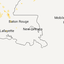
Mississippi
| Local Time | Report Details |
|---|---|
| 4:30 PM CDT | County sheriff reports quite a few trees down around the city in lauderdale county MS, 75.1 miles S of Starkville, MS |
| 4:32 PM CDT | 64 knot peak wind gust measured at meridian key field in lauderdale county MS, 75.1 miles S of Starkville, MS |
| 4:35 PM CDT | Quarter sized hail reported near Meridian, MS, 75.1 miles S of Starkville, MS, quarter size hail reported in the west side of the city |
| 5:50 PM CDT | Attala sheriffs office reported a tree down on county road 52o in attala county MS, 45.9 miles SW of Starkville, MS |
| 7:00 PM CDT | At the jackson futbol club complex on westbrook road... the tops were blown out of a couple of trees. large aluminum soccer goals blown over and tossed some 3-4 fee in hinds county MS, 2.3 miles NW of Jackson, MS |
| 7:10 PM CDT | Quarter sized hail reported near Jackson, MS, 5.2 miles NNE of Jackson, MS, large amounts of pea size hail with some stones up to quarter size at the jackson futbol club |
| 7:45 PM CDT | Quarter sized hail reported near Forest, MS, 40.3 miles ESE of Jackson, MS, hail to the size of quarters along with a couple of trees down along hwy 35. |
| 8:07 PM CDT | Quarter sized hail reported near Clinton, MS, 7.5 miles WNW of Jackson, MS, on interstate 20 |
| 8:07 PM CDT | Quarter sized hail reported near Jackson, MS, 5.3 miles W of Jackson, MS, on interstate 20 |
| 8:20 PM CDT | Three trees down on scr563. two more trees fell on a house on 135 and 13 in smith county MS, 29.7 miles ESE of Jackson, MS |
| 8:30 PM CDT | Pearl pd reports a few trees down in pearl. time estimated by rada in rankin county MS, 4.6 miles ESE of Jackson, MS |
Montana
| Local Time | Report Details |
|---|---|
| 3:39 PM MDT | Quarter sized hail reported near Shepherd, MT, 17.8 miles NNE of Billings, MT |
Iowa
| Local Time | Report Details |
|---|---|
| 4:45 PM CDT | Quarter sized hail reported near Bedford, IA, 79.5 miles ESE of Omaha, NE, report from nssl shave. time approximate |
| 5:00 PM CDT | Quarter sized hail reported near New Market, IA, 69.3 miles ESE of Omaha, NE, report from nssl shave. time estimated. |
| 5:00 PM CDT | Half Dollar sized hail reported near Bedford, IA, 75.1 miles SE of Omaha, NE, report from nssl shave |
| 5:03 PM CDT | Quarter sized hail reported near Bedford, IA, 75.7 miles ESE of Omaha, NE |
| 5:07 PM CDT | Quarter sized hail reported near Bedford, IA, 75.1 miles SE of Omaha, NE, report from nssl shave. |
| 5:30 PM CDT | Quarter sized hail reported near Davis City, IA, 71.6 miles SSW of Des Moines, IA |
| 5:47 PM CDT | Quarter sized hail reported near Creston, IA, 56.7 miles SW of Des Moines, IA, hail up to quarter sized five and a half miles south of creston. delayed report received via twitter. time estimated from radar. |
| 6:08 PM CDT | Quarter sized hail reported near Davis City, IA, 71.6 miles SSW of Des Moines, IA |
| 7:37 PM CDT | Quarter sized hail reported near Prole, IA, 20.2 miles SSW of Des Moines, IA |
| 9:15 PM CDT | Trees were reported down by the sheriffs office in keosauqua... farmington... and bonapar in van buren county IA, 24.8 miles NNW of Kahoka, MO |
| 9:55 PM CDT | Multiple power lines down in burlingto in des moines county IA, 41.4 miles NE of Kahoka, MO |
| 9:57 PM CDT | Pea sized hail in des moines county IA, 40.9 miles NE of Kahoka, MO |
| 10:00 PM CDT | Quarter sized hail reported near Burlington, IA, 41 miles NE of Kahoka, MO, via internet |
| 10:01 PM CDT | Iowa dot in van buren county IA, 24.4 miles NW of Kahoka, MO |
Illinois
| Local Time | Report Details |
|---|---|
| 5:15 PM CDT | Golf Ball sized hail reported near Mc Nabb, IL, 39 miles NNE of Peoria, IL, via twitter |
| 5:15 PM CDT | Spotter esitmated winds speeds of 59 mp in putnam county IL, 39 miles NNE of Peoria, IL |
| 5:30 PM CDT | Quarter sized hail reported near Hennepin, IL, 41.6 miles NNE of Peoria, IL, via facebook |
| 5:32 PM CDT | Quarter sized hail reported near Hennepin, IL, 41.6 miles NNE of Peoria, IL, quarter sized hail is faling with heavy rain |
| 5:35 PM CDT | Quarter sized hail reported near Hennepin, IL, 40.3 miles NNE of Peoria, IL |
| 5:45 PM CDT | Quarter sized hail reported near Granville, IL, 43.4 miles NNE of Peoria, IL, hail just began. |
| 5:45 PM CDT | Quarter sized hail reported near Hennepin, IL, 41.6 miles NNE of Peoria, IL, hail has been falling for the past 15 minutes. |
| 5:45 PM CDT | Half Dollar sized hail reported near Hennepin, IL, 40.5 miles NNE of Peoria, IL |
| 6:13 PM CDT | Quarter sized hail reported near Mc Nabb, IL, 39 miles NNE of Peoria, IL, also heavy rain and frequent lightning. |
| 6:15 PM CDT | Golf Ball sized hail reported near Granville, IL, 37.6 miles NNE of Peoria, IL, via twitter |
| 6:15 PM CDT | Spotter esitmated winds speeds of 59 mp in putnam county IL, 39 miles NNE of Peoria, IL |
| 6:18 PM CDT | Half Dollar sized hail reported near Romeoville, IL, 28.6 miles SW of Chicago, IL, quarter to half dollar size hail at romeoville ema. |
| 6:30 PM CDT | Golf Ball sized hail reported near Lacon, IL, 24.5 miles NNE of Peoria, IL, via twitter |
| 6:35 PM CDT | Half Dollar sized hail reported near Lockport, IL, 32.9 miles SW of Chicago, IL |
| 6:45 PM CDT | Hen Egg sized hail reported near Lockport, IL, 29.6 miles SW of Chicago, IL, 2 inch diameter hail. via facebook. |
| 6:45 PM CDT | Quarter sized hail reported near Shorewood, IL, 37 miles SW of Chicago, IL |
| 6:45 PM CDT | Quarter sized hail reported near Plainfield, IL, 35.7 miles SW of Chicago, IL |
| 6:47 PM CDT | Quarter sized hail reported near Romeoville, IL, 28.6 miles SW of Chicago, IL, nickel to quarter size hail. at the office. |
| 6:48 PM CDT | Ping Pong Ball sized hail reported near Robbins, IL, 17.3 miles SSW of Chicago, IL, ping pong ball sized hail 2 miles west of nws office. via facebook. |
| 7:02 PM CDT | Ping Pong Ball sized hail reported near Lacon, IL, 24.9 miles NNE of Peoria, IL |
| 7:05 PM CDT | Quarter sized hail reported near Sparland, IL, 21 miles NNE of Peoria, IL |
| 7:06 PM CDT | Large tree limbs down on the south side of town in marshall county IL, 23.8 miles NNE of Peoria, IL |
| 7:16 PM CDT | Golf Ball sized hail reported near Minooka, IL, 43.7 miles SW of Chicago, IL |
| 7:20 PM CDT | Grapefruit sized hail reported near Minooka, IL, 43.7 miles SW of Chicago, IL, softball size hail reported at camden drive and kettleson drive in minooka. photo via facebook. |
| 7:25 PM CDT | Hen Egg sized hail reported near Minooka, IL, 43.7 miles SW of Chicago, IL, 2 inch diameter hail. |
| 7:26 PM CDT | Quarter sized hail reported near Shorewood, IL, 38.6 miles SW of Chicago, IL |
| 7:33 PM CDT | Quarter sized hail reported near Channahon, IL, 43.7 miles SW of Chicago, IL, damage to cars reported. |
| 7:40 PM CDT | 10-15 power poles snapped in marshall county IL, 25.2 miles NNE of Peoria, IL |
| 7:48 PM CDT | Half Dollar sized hail reported near Channahon, IL, 43.7 miles SW of Chicago, IL, hail has been falling for 20 minutes. |
| 7:50 PM CDT | Baseball sized hail reported near Minooka, IL, 43.7 miles SW of Chicago, IL, golf ball to baseball sized hail. |
| 7:52 PM CDT | Golf Ball sized hail reported near Channahon, IL, 43.7 miles SW of Chicago, IL |
| 8:10 PM CDT | Half Dollar sized hail reported near Newark, IL, 47.9 miles WSW of Chicago, IL, il route 52 and arbeiter road south of shorewood il. |
| 8:28 PM CDT | Quarter sized hail reported near Princeville, IL, 20.1 miles NW of Peoria, IL, on route 90 |
| 9:00 PM CDT | Trees down on rt. 116 in woodford county IL, 7.3 miles NE of Peoria, IL |
| 9:40 PM CDT | Tree limbs down in knox county IL, 43.5 miles WNW of Peoria, IL |
| 9:40 PM CDT | Storm damage reported in knox county IL, 44.2 miles WNW of Peoria, IL |
| 9:40 PM CDT | Quarter sized hail reported near Knoxville, IL, 39.3 miles WNW of Peoria, IL |
| 9:40 PM CDT | Golf Ball sized hail reported near Galesburg, IL, 44.2 miles WNW of Peoria, IL |
| 9:45 PM CDT | 16 inch diameter healthy tree split and blocked road. corrected tim in tazewell county IL, 5 miles S of Peoria, IL |
| 9:45 PM CDT | 10 inch diameter healthy tree down on douglas and pontiac. corrected tim in tazewell county IL, 5 miles S of Peoria, IL |
| 9:48 PM CDT | 16 inch diameter healthy tree split and blocked road in tazewell county IL, 5 miles S of Peoria, IL |
| 9:57 PM CDT | 10 inch diameter healthy tree down on douglas and pontiac in tazewell county IL, 5 miles S of Peoria, IL |
| 10:00 PM CDT | 14-16 inch diameter tree down blocking townline road at mackinaw river bridge in tazewell county IL, 16.3 miles SSE of Peoria, IL |
| 10:05 PM CDT | Trees and power lines down across southern henderson county. some trees were down on homes. time was estimated from rada in henderson county IL, 46.1 miles ENE of Kahoka, MO |
| 10:08 PM CDT | Storm damage reported in henderson county IL, 48.7 miles ENE of Kahoka, MO |
| 10:10 PM CDT | Quarter sized hail reported near Roseville, IL, 56.4 miles W of Peoria, IL |
| 10:35 PM CDT | Measureed a 61 mph gust just east of the us-67 and il9 intersection near youngstown illinoi in warren county IL, 56.9 miles W of Peoria, IL |
| 11:05 PM CDT | Trees and power lines down across southern henderson county. some trees were down on homes. time was estimated from rada in henderson county IL, 46.1 miles ENE of Kahoka, MO |
| 11:08 PM CDT | Storm damage reported in henderson county IL, 48.7 miles ENE of Kahoka, MO |
South Carolina
| Local Time | Report Details |
|---|---|
| 6:53 PM EDT | Clarendon county dispatch reported downed power lines on walker gamble road near laurel driv in clarendon county SC, 43 miles N of Charleston, SC |
Georgia
| Local Time | Report Details |
|---|---|
| 7:45 PM EDT | Quarter sized hail reported near Leesburg, GA, 79.4 miles WNW of Douglas, GA, photo submitted on social media of estimated quarter size hail just outside of leesburg |
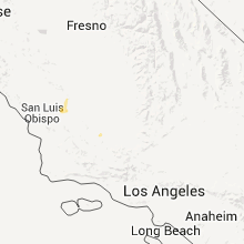
California
| Local Time | Report Details |
|---|---|
| 5:15 PM PDT | Quarter sized hail reported near Taft, CA, 28.7 miles WSW of Bakersfield, CA, hail reported near ford city. |
| 5:45 PM PDT | Quarter sized hail reported near , , 30.9 miles WSW of Bakersfield, CA, hail lasted about 3-4 minutes. reported via social media. |
| 6:15 PM PDT | Chp reported large tree blocking all lanes on belle terrace (400 e block in kern county CA, 1.6 miles SE of Bakersfield, CA |
| 6:31 PM PDT | Chp reported power lines in roadway on east mettler frontage road at valpredo avenu in kern county CA, 20 miles S of Bakersfield, CA |
Utah
| Local Time | Report Details |
|---|---|
| 6:17 PM MDT | Flattop mountain sensor ftmu1 in emery county UT, 21.2 miles SSE of Price, UT |
| 8:45 PM MDT | Otter creek sensor otru1 in rich county UT, 75.3 miles NNE of Salt Lake City, UT |
| 10:45 PM MDT | Bullfrog marina sensor bullf in kane county UT, 107.8 miles SE of Monroe, UT |
Indiana
| Local Time | Report Details |
|---|---|
| 7:53 PM CDT | Tree dow in lake county IN, 42.6 miles SSE of Chicago, IL |
| 9:25 PM EDT | Quarter sized hail reported near Plymouth, IN, 63.9 miles WNW of Fort Wayne, IN, quarter size hail at us 30 and us 31 near plymouth |
| 9:50 PM EDT | Multiple trees and power lines down in kosciusko county IN, 39.1 miles WNW of Fort Wayne, IN |
New York
| Local Time | Report Details |
|---|---|
| 9:01 PM EDT | Numerous reports of trees and powerlines down in monroe county NY, 58 miles ENE of Buffalo, NY |
| 9:04 PM EDT | Large tree down in monroe county NY, 62.6 miles ENE of Buffalo, NY |
| 9:04 PM EDT | Numerous trees and powerlines down in monroe county NY, 66.8 miles ENE of Buffalo, NY |
| 9:15 PM EDT | Numerous reports of trees and powerlines down in monroe county NY, 58.1 miles ENE of Buffalo, NY |
| 9:21 PM EDT | Storm damage reported in monroe county NY, 62.8 miles ENE of Buffalo, NY |
| 9:26 PM EDT | Large tree down on parked car in a driveway in monroe county NY, 65.5 miles ENE of Buffalo, NY |
| 9:26 PM EDT | Numerous trees and powerlines down in monroe county NY, 66.8 miles ENE of Buffalo, NY |
| 9:27 PM EDT | Large tree and powerlines down in wayne county NY, 48 miles WNW of Syracuse, NY |
| 9:28 PM EDT | Roof damage at a grocery store in monroe county NY, 65.5 miles ENE of Buffalo, NY |
| 9:31 PM EDT | Trees and a transformer down in monroe county NY, 69.5 miles W of Syracuse, NY |
| 9:36 PM EDT | Numerous reports of trees and wires down in monroe county NY, 66.5 miles W of Syracuse, NY |
| 9:36 PM EDT | Quarter sized hail reported near Fairport, NY, 65.5 miles W of Syracuse, NY |
| 9:38 PM EDT | Large tree down across road in monroe county NY, 67.5 miles W of Syracuse, NY |
| 9:43 PM EDT | Trees down in road in wayne county NY, 58.4 miles W of Syracuse, NY |
| 9:45 PM EDT | Quarter sized hail reported near Macedon, NY, 58.4 miles W of Syracuse, NY |
| 9:46 PM EDT | Powerlines down and possible barn collapse on shortsville rd in ontario county NY, 59.5 miles W of Syracuse, NY |
| 9:47 PM EDT | Large grain silo blown 300 feeet in ontario county NY, 59.5 miles W of Syracuse, NY |
| 9:57 PM EDT | Powerlines and large limbs down. tree limb fell on parked ca in livingston county NY, 57.3 miles E of Buffalo, NY |
| 10:05 PM EDT | Grain bin collapsed in ontario county NY, 46.7 miles W of Syracuse, NY |
| 10:07 PM EDT | 3 trees down in ontario county NY, 46.7 miles W of Syracuse, NY |
| 10:09 PM EDT | Numerous trees down in ontario county NY, 64.1 miles W of Syracuse, NY |
| 10:19 PM EDT | Numerous trees down in ontario county NY, 55.1 miles W of Syracuse, NY |
| 10:23 PM EDT | Numerous trees down in ontario county NY, 50.2 miles W of Syracuse, NY |
| 10:30 PM EDT | Several trees down in seneca county NY, 34.5 miles WSW of Syracuse, NY |
| 11:03 PM EDT | Several trees down including 2 against house in seneca county NY, 40.4 miles WSW of Syracuse, NY |
| 11:05 PM EDT | Tree dow in cayuga county NY, 26.9 miles SW of Syracuse, NY |
| 11:10 PM EDT | Multiple trees and limbs dow in seneca county NY, 35.5 miles WSW of Syracuse, NY |
| 11:10 PM EDT | Tree down blocking road. radar estimated tim in cayuga county NY, 23.8 miles SSW of Syracuse, NY |
Ohio
| Local Time | Report Details |
|---|---|
| 9:26 PM EDT | Half Dollar sized hail reported near Wauseon, OH, 59.6 miles NE of Fort Wayne, IN |
| 10:03 PM EDT | Tree down along county road t between county roads 14 and 15. time estimated from rada in henry county OH, 55.5 miles ENE of Fort Wayne, IN |
| 11:07 PM EDT | Multiple reports of trees down and power outages in defiance. winds estimated between 60 and 65 mph. pea to dime sized hail was also reporte in defiance county OH, 41 miles ENE of Fort Wayne, IN |
| 11:15 PM EDT | A tree fell on a house and powerlines on market street in florida in henry county OH, 49.8 miles ENE of Fort Wayne, IN |
Michigan
| Local Time | Report Details |
|---|---|
| 11:47 PM EDT | Measured with home anemomete in monroe county MI, 76.9 miles S of Flint, MI |
| 11:47 PM EDT | Hen Egg sized hail reported near Ida, MI, 76.9 miles S of Flint, MI |
| 11:55 PM EDT | Quarter sized hail reported near Monroe, MI, 76.5 miles S of Flint, MI, one inch hail occurred for five minutes between 1155 pm and midnight. |
| 11:55 PM EDT | Golf Ball sized hail reported near Monroe, MI, 77.8 miles S of Flint, MI |
Connect with Interactive Hail Maps