

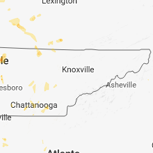
Hail Map for Monday, June 11, 2018

Number of Impacted Households on 6/11/2018
0
Impacted by 1" or Larger Hail
0
Impacted by 1.75" or Larger Hail
0
Impacted by 2.5" or Larger Hail
Square Miles of Populated Area Impacted on 6/11/2018
0
Impacted by 1" or Larger Hail
0
Impacted by 1.75" or Larger Hail
0
Impacted by 2.5" or Larger Hail


Cities Most Affected by Hail Storms of 6/11/2018
| Hail Size | Demographics of Zip Codes Affected | ||||||
|---|---|---|---|---|---|---|---|
| City | Count | Average | Largest | Pop Density | House Value | Income | Age |
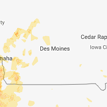
| Tecumseh, NE | 2 | 2.25 | 2.75 | 14 | $53k | $31.1k | 41.1 |
| Gretna, NE | 2 | 1.88 | 2.00 | 175 | $126k | $57.8k | 33.4 |
| Nickerson, KS | 2 | 1.75 | 1.75 | 16 | $48k | $33.2k | 40.0 |
| Elk Creek, NE | 1 | 2.50 | 2.50 | 5 | $43k | $37.5k | 48.9 |
| Cook, NE | 1 | 2.00 | 2.00 | 4 | $53k | $33.6k | 44.9 |
| Clay City, IL | 1 | 1.75 | 1.75 | 12 | $47k | $29.1k | 43.4 |
| Omaha, NE | 1 | 1.75 | 1.75 | 1763 | $209k | $81.7k | 31.6 |
| Fremont, NE | 1 | 1.75 | 1.75 | 246 | $90k | $38.3k | 39.5 |
| Hutchinson, KS | 1 | 1.75 | 1.75 | 297 | $94k | $45.1k | 46.4 |
| Louisville, NE | 1 | 1.75 | 1.75 | 27 | $91k | $45.6k | 42.6 |
| Elmwood, NE | 1 | 1.75 | 1.75 | 15 | $82k | $47.1k | 39.7 |
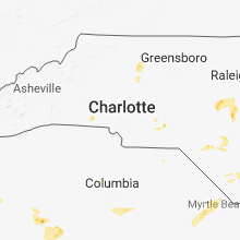
| Kings Mountain, NC | 1 | 1.75 | 1.75 | 308 | $89k | $37.6k | 41.3 |
| Polo, MO | 1 | 1.75 | 1.75 | 22 | $59k | $40.8k | 44.7 |
Hail and Wind Damage Spotted on 6/11/2018
Filter by Report Type:Hail ReportsWind Reports
States Impacted
North Carolina, Louisiana, Georgia, South Carolina, Kentucky, Florida, Nebraska, Illinois, Minnesota, Iowa, Tennessee, Missouri, Kansas, OklahomaNorth Carolina
| Local Time | Report Details |
|---|---|
| 1:25 PM EDT | Significant damage to trailer and minor damage to camper trailer in craven county NC, 86 miles NNE of Wilmington, NC |
| 1:40 PM EDT | Tree down on juniper rd near roanoke r in sampson county NC, 44.3 miles SSE of Raleigh, NC |
| 2:20 PM EDT | Trained spotter reported power lines down and pea sized hai in duplin county NC, 53.9 miles SSE of Raleigh, NC |
| 2:20 PM EDT | Trees down in seven springs are in lenoir county NC, 59.8 miles SE of Raleigh, NC |
| 2:26 PM EDT | Trees down blocking the road on jones turner road and highway 3 in duplin county NC, 55.3 miles SE of Raleigh, NC |
| 2:48 PM EDT | Trees down across the county. time estimated by rada in lenoir county NC, 69.6 miles ESE of Raleigh, NC |
| 4:49 PM EDT | Quarter sized hail reported near Lillington, NC, 30.3 miles SSW of Raleigh, NC, quarter-sized hail reported at a family dollar store in lillington. |
| 5:01 PM EDT | Thunderstorm winds downed a tree along east church street near benson... n in johnston county NC, 28.5 miles SSE of Raleigh, NC |
| 5:06 PM EDT | Harnett county sheriff's office reported several trees down along a 150-foot section of roadway on olive branch rd near kipling rd in fuquay-varin in harnett county NC, 23.6 miles SSW of Raleigh, NC |
| 5:08 PM EDT | Quarter sized hail reported near Dunn, NC, 36.9 miles S of Raleigh, NC, quarter-sized hail reported on i-95 at exit 70. |
| 5:08 PM EDT | Quarter sized hail reported near Dunn, NC, 34.2 miles S of Raleigh, NC, quarter-sized hail reported on i-95 at exit 72. |
| 5:10 PM EDT | Thunderstorm wind gusts downed one tree near the community of dun in sampson county NC, 35.8 miles S of Raleigh, NC |
| 5:25 PM EDT | Two trees down near cornelius roa in yadkin county NC, 65.9 miles NNE of Charlotte, NC |
| 5:27 PM EDT | Thunderstorm winds downed several trees along route 421 just east of the yadkin county borde in forsyth county NC, 63.4 miles NNE of Charlotte, NC |
| 5:30 PM EDT | Several trees and large limbs down along baltimore road in forbush in yadkin county NC, 64.4 miles NNE of Charlotte, NC |
| 5:32 PM EDT | Tree down on a power line... shallowfrod road at williams s in forsyth county NC, 62.8 miles NNE of Charlotte, NC |
| 5:55 PM EDT | Thunderstorm winds downed numerous trees across northern sampson county... centered mainly near the community of vann crossroad in sampson county NC, 48.7 miles SSE of Raleigh, NC |
| 6:00 PM EDT | Several trees down in the mocksville area and one report of a tree down in the farmington area. time obtained from radar dat in davie county NC, 49.3 miles NNE of Charlotte, NC |
| 7:03 PM EDT | Tree down on flat rock road. time obtained from radar dat in rowan county NC, 26.9 miles NNE of Charlotte, NC |
| 7:07 PM EDT | Trees and powerlines down on airport road in rowan county NC, 25.1 miles NNE of Charlotte, NC |
| 8:28 PM EDT | Multiple trees and powerlines down in the oak hill are in burke county NC, 61 miles SSE of Bristol, TN |
| 9:25 PM EDT | Golf Ball sized hail reported near Kings Mountain, NC, 31.9 miles W of Charlotte, NC, broadcast media reported golf ball (1.75 in) size hail in the kings mountain area. |
| 9:32 PM EDT | Quarter sized hail reported near Kings Mountain, NC, 35.2 miles W of Charlotte, NC, quarter sized hail on long branch road north of grover and east of patterson springs. |
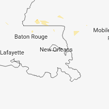
Louisiana
| Local Time | Report Details |
|---|---|
| 12:37 PM CDT | Kmsy reported peak wind of 54kt in jefferson county LA, 10.5 miles W of New Orleans, LA |
Georgia
| Local Time | Report Details |
|---|---|
| 2:00 PM EDT | *** 1 inj *** emergency manager reports mulitple trees down along pleasant hill church road ne near the intersections of whispering pine road and hwy211. trees were rep in barrow county GA, 47.1 miles ENE of Atlanta, GA |
| 3:06 PM EDT | Media report from chattanooga (wrcb) of 2 large trees down on a house off chambers road. no injuries. time estimated from rada in walker county GA, 5.5 miles SSE of Chattanooga, TN |
| 3:30 PM EDT | White county emergency management reports a tree down on powerlines on daybreak roa in white county GA, 66.9 miles NNE of Atlanta, GA |
| 4:00 PM EDT | A tree was blown down across mahan rd... just nnw of summerville in chattooga county GA, 37.1 miles S of Chattanooga, TN |
| 4:00 PM EDT | Emergency manager reports a tree down with lines in it on peach blossom lane in chattooga county GA, 37.7 miles S of Chattanooga, TN |
| 4:05 PM EDT | A large tree limb was down in the road near the intersection of hwy 27 and greeson st in chattooga county GA, 37 miles S of Chattanooga, TN |
| 4:35 PM EDT | A large tree fell onto a home on w. wieuca rd with no injuries reporte in fulton county GA, 9.1 miles N of Atlanta, GA |
| 4:45 PM EDT | A large tree fell onto a home on w. wieuca rd with no injuries reporte in fulton county GA, 9.1 miles N of Atlanta, GA |
| 5:00 PM EDT | Emergency manager reports a tree on a powerline on greeson stree in chattooga county GA, 41.2 miles S of Chattanooga, TN |
| 5:06 PM EDT | *** 1 inj *** a tree was blown onto a residence in decatur on sycamore st... one person was trappen in the home and injured. (updated lat/lon) in dekalb county GA, 6.8 miles ENE of Atlanta, GA |
| 5:06 PM EDT | *** 1 inj *** a tree was blown onto a residence in decatur on sycamore st... one person was trappen in the home and injure in dekalb county GA, 9 miles NE of Atlanta, GA |
| 5:07 PM EDT | Public report relayed by media of several larger trees down near intersection of south columbia drive and shadowmoor drive in decatur... and also along sams street. tim in dekalb county GA, 6 miles ENE of Atlanta, GA |
| 5:16 PM EDT | Columbia county dispatch reported trees down on louisville rd at lanatte ln. time estimated based on rada in columbia county GA, 17.7 miles W of Augusta, GA |
| 5:30 PM EDT | Report of trees and powerlines down at the intersection of boykin road and peach orchard roa in richmond county GA, 9 miles SSW of Augusta, GA |
| 5:40 PM EDT | Half Dollar sized hail reported near Harlem, GA, 20.9 miles W of Augusta, GA, member of the public reported hail up to half dollar size in harlem... ga. video of hail shared via social media. |
| 5:43 PM EDT | Quarter sized hail reported near Augusta, GA, 8.2 miles SSW of Augusta, GA, public reported quarter sized hail near the intersection of highway 25 and tobacco road (location approximate). |
| 5:43 PM EDT | Public reported tree limbs down and a trampoline was blown an estimated 300 feet from the propert in richmond county GA, 10.8 miles SW of Augusta, GA |
| 5:48 PM EDT | Quarter sized hail reported near Hephzibah, GA, 10.2 miles SW of Augusta, GA, public reported quarter sized hail at the intersection of windsor spring road and diamond lakes way. via social media. |
| 5:48 PM EDT | Half Dollar sized hail reported near Hephzibah, GA, 8.8 miles SW of Augusta, GA, public reported half dollar sized hail via social media near the intersection of windsor spring road and tobacco road. |
| 6:33 PM EDT | County dispatch reported trees down on liberty street in downtown waynesbor in burke county GA, 26.9 miles S of Augusta, GA |
| 6:35 PM EDT | County dispatch reported trees down on george perkins road off of highway 2 in burke county GA, 22.3 miles S of Augusta, GA |
| 11:25 PM EDT | A tree was blown down across burketts ferry road... between hazelhurst and snipesvill in jeff davis county GA, 22.2 miles NNE of Douglas, GA |
South Carolina
| Local Time | Report Details |
|---|---|
| 2:04 PM EDT | Highway patrol reported trees down on goodwin road at goodwin way. time estimated based on rada in richland county SC, 63.7 miles NW of Charleston, SC |
| 2:55 PM EDT | Public reported trees down and dime size hail near saint matthews via twitter. time estimated based on rada in calhoun county SC, 55 miles NW of Charleston, SC |
| 3:07 PM EDT | Highway patrol reported a tree down on i-95 at the 146 sb mile marker in sumter county. time estimated based on rada in sumter county SC, 57.5 miles N of Charleston, SC |
| 3:07 PM EDT | Sumter county dispatch reported trees down on powerlines near mayesvill in sumter county SC, 55.2 miles NNW of Charleston, SC |
Kentucky
| Local Time | Report Details |
|---|---|
| 2:37 PM EDT | Tree down. time estimated using rada in meade county KY, 29.1 miles W of Louisville, KY |
| 3:40 PM EDT | 1 tree dow in nelson county KY, 22.3 miles ESE of Louisville, KY |
| 3:53 PM EDT | Corrects previous report for time. tree down on cardwell rd. time estimated using rada in washington county KY, 38 miles ESE of Louisville, KY |
| 3:53 PM EDT | Corrects previous report for time. tree reported down on polin rd. time estimated using rada in washington county KY, 31 miles ESE of Louisville, KY |
| 3:58 PM EDT | Corrects previous report for time. tree down on hayes ln. time estimated using rada in washington county KY, 28 miles ESE of Louisville, KY |
| 2:58 PM CDT | Tree down on power lin in hart county KY, 40.5 miles S of Louisville, KY |
| 4:11 PM EDT | Corrects previous report for time. multiple trees down. time estimated using rada in washington county KY, 36.8 miles ESE of Louisville, KY |
| 4:14 PM EDT | Corrects previous report for time. tree down on rush run ln. time estimated using rada in washington county KY, 39.7 miles ESE of Louisville, KY |
| 4:56 PM EDT | Tree down on hayes l in washington county KY, 28 miles ESE of Louisville, KY |
| 4:56 PM EDT | Tree down on cardwell r in washington county KY, 38 miles ESE of Louisville, KY |
| 4:56 PM EDT | Tree down on rush run l in washington county KY, 39.7 miles ESE of Louisville, KY |
| 4:56 PM EDT | Tree reported down on polin r in washington county KY, 31 miles ESE of Louisville, KY |
| 4:56 PM EDT | Multiple trees dow in washington county KY, 36.8 miles ESE of Louisville, KY |
| 5:02 PM EDT | Tree down at richmond st and s campbell s in garrard county KY, 33.6 miles W of Irvine, KY |
| 5:07 PM EDT | Tree down on ky1778. time estimated using rada in lincoln county KY, 46 miles WSW of Irvine, KY |
| 4:18 PM CDT | Communications tower blown dow in adair county KY, 65 miles SSE of Louisville, KY |
| 4:18 PM CDT | Communications tower blown dow in adair county KY, 65 miles SSE of Louisville, KY |
| 5:18 PM EDT | Tree down on preachersville rd. time estimated using rada in lincoln county KY, 34.9 miles WSW of Irvine, KY |
| 4:18 PM CDT | Communications tower buckle in green county KY, 57.9 miles S of Louisville, KY |
| 4:18 PM CDT | Road closed due to downed tree in metcalfe county KY, 57.1 miles S of Louisville, KY |
| 6:55 PM EDT | A tree was blown down onto a powerline and a garage resulting in a structure fire. the time of the event is estimated from radar dat in mccreary county KY, 62.5 miles SSW of Irvine, KY |
| 7:11 PM EDT | Several trees were blown down along bee creek road. the time of the event is estiatmed from radar dat in whitley county KY, 56.7 miles SSW of Irvine, KY |
Florida
| Local Time | Report Details |
|---|---|
| 3:45 PM EDT | Reports of multiple trees struck by lightning... downed powerlines... downed trees on powerlines... small brush fires... and some minor flooding in and around the city in st. johns county FL, 36.8 miles SE of Jacksonville, FL |
Nebraska
| Local Time | Report Details |
|---|---|
| 5:00 PM CDT | Hen Egg sized hail reported near Gretna, NE, 17.6 miles WSW of Omaha, NE |
| 5:00 PM CDT | Golf Ball sized hail reported near Gretna, NE, 17.1 miles WSW of Omaha, NE |
| 5:00 PM CDT | Quarter sized hail reported near Gretna, NE, 20.8 miles SW of Omaha, NE |
| 5:04 PM CDT | Ping Pong Ball sized hail reported near Omaha, NE, 14.7 miles WSW of Omaha, NE |
| 5:10 PM CDT | Golf Ball sized hail reported near Omaha, NE, 15.1 miles WSW of Omaha, NE |
| 5:10 PM CDT | Quarter sized hail reported near Lyons, NE, 54.3 miles NNW of Omaha, NE |
| 5:25 PM CDT | Ping Pong Ball sized hail reported near Louisville, NE, 24.2 miles SSW of Omaha, NE |
| 5:29 PM CDT | Golf Ball sized hail reported near Fremont, NE, 31.1 miles WNW of Omaha, NE |
| 5:30 PM CDT | Quarter sized hail reported near Fremont, NE, 30.9 miles WNW of Omaha, NE |
| 5:30 PM CDT | 12" diameter trees down in louisville numerous wind damage across the town. also had ping pong size hail. many windows are broken. time estimated from rada in cass county NE, 21.3 miles SSW of Omaha, NE |
| 5:36 PM CDT | Ping Pong Ball sized hail reported near Fremont, NE, 31.6 miles WNW of Omaha, NE |
| 5:38 PM CDT | Half Dollar sized hail reported near Omaha, NE, 13.6 miles W of Omaha, NE |
| 6:10 PM CDT | Quarter sized hail reported near Papillion, NE, 14.1 miles SSW of Omaha, NE |
| 6:34 PM CDT | Golf Ball sized hail reported near Louisville, NE, 24.2 miles SW of Omaha, NE |
| 6:35 PM CDT | Quarter sized hail reported near Eagle, NE, 39.7 miles SW of Omaha, NE |
| 6:35 PM CDT | Reports of multiple trees down... boats broken from dock in cass county NE, 16.8 miles SSW of Omaha, NE |
| 6:41 PM CDT | Golf Ball sized hail reported near Elmwood, NE, 34.3 miles SSW of Omaha, NE |
| 7:05 PM CDT | Personal weather station in cass county NE, 31.3 miles S of Omaha, NE |
| 7:05 PM CDT | Corrects time of previous tstm wnd dmg report from 4 ene union. lake wa con-da had substantial wind damage to homes. many homes have roof and tree damage. many power po in cass county NE, 29.3 miles S of Omaha, NE |
| 7:15 PM CDT | Tree branches blown onto roa in otoe county NE, 40.3 miles S of Omaha, NE |
| 7:16 PM CDT | Half Dollar sized hail reported near Sterling, NE, 58.7 miles SSW of Omaha, NE |
| 7:18 PM CDT | Storm damage reported in otoe county NE, 50.6 miles S of Omaha, NE |
| 7:21 PM CDT | Quarter sized hail reported near Sterling, NE, 59.9 miles SSW of Omaha, NE |
| 7:21 PM CDT | Quarter sized hail reported near Tecumseh, NE, 63.5 miles SSW of Omaha, NE |
| 7:33 PM CDT | Golf Ball sized hail reported near Tecumseh, NE, 64.5 miles SSW of Omaha, NE |
| 7:35 PM CDT | Hen Egg sized hail reported near Cook, NE, 53.1 miles SSW of Omaha, NE |
| 7:40 PM CDT | Quarter sized hail reported near Cook, NE, 54.9 miles S of Omaha, NE |
| 7:45 PM CDT | Baseball sized hail reported near Tecumseh, NE, 61.2 miles S of Omaha, NE |
| 8:13 PM CDT | Tennis Ball sized hail reported near Elk Creek, NE, 70 miles SSW of Omaha, NE |
| 8:19 PM CDT | Quarter sized hail reported near Table Rock, NE, 74.1 miles NNE of Manhattan, KS |
| 8:40 PM CDT | Quarter sized hail reported near Humboldt, NE, 75.3 miles S of Omaha, NE |
| 9:26 PM CDT | Lake wa con-da had substantial wind damage to homes. many homes have roof and tree damage. many power poles dow in cass county NE, 29.3 miles S of Omaha, NE |
Illinois
| Local Time | Report Details |
|---|---|
| 5:55 PM CDT | Estimated 60 mph gust observed on the east side of shipman. tree limbs approximately 6 inches in diameter reported dow in macoupin county IL, 35 miles NNE of Saint Louis, MO |
| 6:20 PM CDT | Large tree limbs blown down and a power pole down. time estimate in shelby county IL, 15.9 miles SW of Mattoon, IL |
| 6:28 PM CDT | Quarter sized hail reported near Godfrey, IL, 23.6 miles N of Saint Louis, MO |
| 6:54 PM CDT | Quarter sized hail reported near Clay City, IL, 58.1 miles S of Mattoon, IL |
| 7:05 PM CDT | Ping Pong Ball sized hail reported near Clay City, IL, 59.6 miles NW of Evansville, IN |
| 7:10 PM CDT | Golf Ball sized hail reported near Clay City, IL, 58.8 miles S of Mattoon, IL |
| 7:37 PM CDT | Quarter sized hail reported near Dieterich, IL, 29.1 miles S of Mattoon, IL |
| 8:00 PM CDT | Large trees down in petrolia. time estimated by rada in lawrence county IL, 55.9 miles NNW of Evansville, IN |
| 8:05 PM CDT | Tree damage. type and size unknow in marion county IL, 62.2 miles E of Saint Louis, MO |
| 8:25 PM CDT | Spotter reported 4 to 16 inch tree limbs down. time estimated from rada in marion county IL, 66 miles E of Saint Louis, MO |
Minnesota
| Local Time | Report Details |
|---|---|
| 6:30 PM CDT | Large tree limb split. time estimated from rada in hennepin county MN, 21.7 miles NW of Minneapolis, MN |
| 7:20 PM CDT | Large tree uprooted. estimated 20 inches in diameter. time estimated from rada in hennepin county MN, 19.5 miles W of Minneapolis, MN |
| 7:30 PM CDT | Em report of trees and power lines down several locations in southwest hennepin county: mound... excelsior... long lake... wayzata... minnetonka... golden valley... ply in hennepin county MN, 15.9 miles WSW of Minneapolis, MN |
| 7:30 PM CDT | Large tree down. estimated 18 inches in diameter. time estimated from rada in hennepin county MN, 18.2 miles W of Minneapolis, MN |
| 7:30 PM CDT | 20 inch diameter ash tree snapped midtrunk. large oak fell near responding fire truck. time estimated from rada in hennepin county MN, 15.7 miles W of Minneapolis, MN |
| 7:35 PM CDT | Tree 1 ft in diameter blocking both lanes of traffic on ferndale r in hennepin county MN, 12.5 miles W of Minneapolis, MN |
| 7:35 PM CDT | Several species of trees with broken limbs. max limb diameter 7 inches. time estimated from rada in hennepin county MN, 14.5 miles W of Minneapolis, MN |
| 7:40 PM CDT | Time estimated. large limbs and and a wooden fence dow in hennepin county MN, 11.2 miles W of Minneapolis, MN |
Iowa
| Local Time | Report Details |
|---|---|
| 7:00 PM CDT | Total of 9 semis overturned along i-29. 2 drivers were injured and taken by ambulance. interstate 29 was closed both north and southbound. numerous power lines are down in fremont county IA, 31.2 miles SSE of Omaha, NE |
| 7:01 PM CDT | Storm damage reported in pottawattamie county IA, 25.6 miles E of Omaha, NE |
| 7:10 PM CDT | Storm damage reported in fremont county IA, 32 miles SSE of Omaha, NE |
| 7:13 PM CDT | Three semis overturned on interstate 2 in fremont county IA, 31.2 miles SSE of Omaha, NE |
| 7:15 PM CDT | 3 farm storage buildings destroye in fremont county IA, 35.3 miles SSE of Omaha, NE |
| 7:22 PM CDT | Storm damage reported in fremont county IA, 38.6 miles SSE of Omaha, NE |
| 7:28 PM CDT | Shingles blown off. 1 inch tree limbs blown dow in montgomery county IA, 42.2 miles SE of Omaha, NE |
| 7:35 PM CDT | Storm damage reported in page county IA, 45.6 miles SE of Omaha, NE |
| 7:38 PM CDT | Storm damage reported in montgomery county IA, 40.1 miles ESE of Omaha, NE |
| 7:38 PM CDT | Storm damage reported in fremont county IA, 44 miles SE of Omaha, NE |
| 8:01 PM CDT | Storm damage reported in page county IA, 59.2 miles SE of Omaha, NE |
| 8:03 PM CDT | Storm damage reported in page county IA, 59.2 miles SE of Omaha, NE |
| 8:15 PM CDT | Storm damage reported in page county IA, 60.5 miles SE of Omaha, NE |
| 8:21 PM CDT | County sheriff received report of 60 to 70 mph winds about 4 miles north of new market. time estimated from rada in taylor county IA, 63.3 miles ESE of Omaha, NE |
| 8:30 PM CDT | Storm damage reported in taylor county IA, 72.7 miles SE of Omaha, NE |
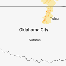
| 8:35 PM CDT | Quarter sized hail reported near Rockwell City, IA, 32.1 miles ESE of Storm Lake, IA, largest hailstones were quarter sized. |
Tennessee
| Local Time | Report Details |
|---|---|
| 7:27 PM CDT | Trees down on zeiglers fort road and cairo road near bledsoe creek state park in sumner county TN, 26.5 miles ENE of Nashville, TN |
| 7:39 PM CDT | Quarter sized hail reported near Castalian Springs, TN, 30 miles ENE of Nashville, TN, quarter sized hail on south wright street in castalian springs |
| 7:39 PM CDT | Quarter sized hail reported near Castalian Springs, TN, 30.3 miles ENE of Nashville, TN |
Missouri
| Local Time | Report Details |
|---|---|
| 8:12 PM CDT | Storm damage reported in atchison county MO, 64 miles SSE of Omaha, NE |
| 8:15 PM CDT | Storm damage reported in atchison county MO, 75.3 miles SSE of Omaha, NE |
| 8:15 PM CDT | Measured by wind turbine...time estimated based on rada in atchison county MO, 67.5 miles SSE of Omaha, NE |
| 8:17 PM CDT | Storm damage reported in atchison county MO, 74.4 miles SSE of Omaha, NE |
| 8:18 PM CDT | Trees uproote in atchison county MO, 64 miles SSE of Omaha, NE |
| 9:05 PM CDT | Storm damage reported in gentry county MO, 79.7 miles N of Kansas City, MO |
| 10:05 PM CDT | Large tree limb fell on fire truck. the limb was too large for them to move without equipment. no injuries to the crew... minor damage to the fire truc in buchanan county MO, 48.2 miles NNW of Kansas City, MO |
| 10:47 PM CDT | Golf Ball sized hail reported near Polo, MO, 42.9 miles NE of Kansas City, MO, nickel to golf ball sized hail. |
| 11:58 PM CDT | 4 to 5 inch branch down near the intersection of wyatt and adams dairy parkway. time estimated by rada in jackson county MO, 19.7 miles ESE of Kansas City, MO |
Kansas
| Local Time | Report Details |
|---|---|
| 8:54 PM CDT | Ping Pong Ball sized hail reported near Axtell, KS, 50.3 miles NNE of Manhattan, KS, report received via a social media post on wibw. delayed report. |
| 9:00 PM CDT | Quarter sized hail reported near Axtell, KS, 53.2 miles NNE of Manhattan, KS |
| 9:00 PM CDT | Quarter sized hail reported near Baileyville, KS, 49.3 miles NNE of Manhattan, KS |
| 9:00 PM CDT | Some tree limbs were also reported down in reserve - diameter unknow in brown county KS, 76.9 miles NE of Manhattan, KS |
| 9:00 PM CDT | Storm damage reported in brown county KS, 75.2 miles NW of Kansas City, MO |
| 9:06 PM CDT | Quarter sized hail reported near Baileyville, KS, 50 miles NNE of Manhattan, KS |
| 9:25 PM CDT | Trees blown over and lots of limbs down in hiawath in brown county KS, 71.6 miles NE of Manhattan, KS |
| 10:10 PM CDT | Quarter sized hail reported near Horton, KS, 57.3 miles NW of Kansas City, MO, storm spotter reported quarter size hail and 50mph winds. |
| 10:33 PM CDT | Quarter sized hail reported near Soldier, KS, 40.7 miles NE of Manhattan, KS |
| 10:36 PM CDT | Storm damage reported in jefferson county KS, 45.6 miles WNW of Kansas City, MO |
| 10:45 PM CDT | Storm damage reported in pottawatomie county KS, 20.7 miles E of Manhattan, KS |
| 10:55 PM CDT | Storm damage reported in jackson county KS, 42.4 miles ENE of Manhattan, KS |
| 11:01 PM CDT | Quarter sized hail reported near Sterling, KS, 53.4 miles NW of Wichita, KS |
| 11:04 PM CDT | Golf Ball sized hail reported near Nickerson, KS, 50.1 miles NW of Wichita, KS, quarter to golf ball size hail reported. |
| 11:05 PM CDT | Golf Ball sized hail reported near Hutchinson, KS, 41.5 miles NW of Wichita, KS, highlands at 82nd and monroe. via social media. |
| 11:07 PM CDT | Quarter sized hail reported near Hutchinson, KS, 43.6 miles NW of Wichita, KS |
| 11:07 PM CDT | Golf Ball sized hail reported near Nickerson, KS, 49.7 miles NW of Wichita, KS |
| 11:10 PM CDT | Quarter sized hail reported near Hutchinson, KS, 41.9 miles NW of Wichita, KS |
| 11:15 PM CDT | Quarter sized hail reported near Hutchinson, KS, 45.7 miles NW of Wichita, KS |
| 11:15 PM CDT | Storm damage reported in shawnee county KS, 47.8 miles E of Manhattan, KS |
| 11:18 PM CDT | Half Dollar sized hail reported near Hutchinson, KS, 41 miles NW of Wichita, KS, west side of hutchinson. via social media. |
| 11:19 PM CDT | Ping Pong Ball sized hail reported near Hutchinson, KS, 43.6 miles NW of Wichita, KS, mping report |
| 11:28 PM CDT | Storm damage reported in shawnee county KS, 51.1 miles E of Manhattan, KS |
| 11:28 PM CDT | Multiple tree limbs down in the oakland and tecumseh areas. diameters of the branches range from 1 inch to 5 inche in shawnee county KS, 48.2 miles E of Manhattan, KS |
| 11:29 PM CDT | Quarter sized hail reported near Hutchinson, KS, 41.9 miles NW of Wichita, KS |
| 11:31 PM CDT | Interstate 70 and highway 75 interchange in shawnee county KS, 48.2 miles E of Manhattan, KS |
| 11:35 PM CDT | Storm damage reported in shawnee county KS, 52.1 miles ESE of Manhattan, KS |
| 11:45 PM CDT | Quarter sized hail reported near Topeka, KS, 43.5 miles ESE of Manhattan, KS |
| 11:45 PM CDT | Emergency management reports several large tree limbs... 4 to 6 inches in diameter... down across the city of baseho in leavenworth county KS, 19.3 miles W of Kansas City, MO |
| 12:02 AM CDT | Quarter sized hail reported near Lawrence, KS, 40.7 miles WSW of Kansas City, MO |
| 12:02 AM CDT | Storm damage reported in douglas county KS, 40.7 miles WSW of Kansas City, MO |
| 12:03 AM CDT | Quarter sized hail reported near Lawrence, KS, 38.1 miles WSW of Kansas City, MO |
| 12:08 AM CDT | Ping Pong Ball sized hail reported near Lawrence, KS, 39.1 miles WSW of Kansas City, MO |
| 12:15 AM CDT | Nickel sized hail also reported in reno county KS, 39.3 miles WNW of Wichita, KS |
| 12:15 AM CDT | Reports of 5 inch diameter tree limbs dow in shawnee county KS, 49.6 miles E of Manhattan, KS |
| 12:20 AM CDT | Half Dollar sized hail reported near Baldwin City, KS, 39.6 miles SW of Kansas City, MO |
| 12:37 AM CDT | Power lines were reported down in the city of ottaw in franklin county KS, 49.8 miles SW of Kansas City, MO |
| 12:39 AM CDT | Storm damage reported in franklin county KS, 52.9 miles SW of Kansas City, MO |
| 3:10 AM CDT | Storm damage reported in neosho county KS, 1 miles SSW of Chanute, KS |
| 3:22 AM CDT | Storm damage reported in labette county KS, 25.6 miles SSE of Chanute, KS |
| 3:35 AM CDT | Storm damage reported in montgomery county KS, 45.4 miles SSW of Chanute, KS |
| 3:55 AM CDT | Storm damage reported in montgomery county KS, 34.3 miles SSW of Chanute, KS |
| 4:06 AM CDT | Police report no power in the city with a lot of tree damage and large limbs down in montgomery county KS, 28.9 miles S of Chanute, KS |
Oklahoma
| Local Time | Report Details |
|---|---|
| 5:10 AM CDT | Storm damage reported in delaware county OK, 59.8 miles ENE of Tulsa, OK |
| 5:10 AM CDT | Storm damage reported in mayes county OK, 45.1 miles ENE of Tulsa, OK |
| 5:10 AM CDT | Storm damage reported in mayes county OK, 45.1 miles ENE of Tulsa, OK |
Connect with Interactive Hail Maps