

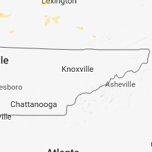
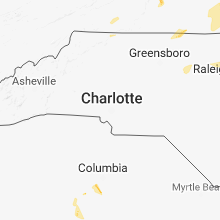
Hail Map for Sunday, June 10, 2018

Number of Impacted Households on 6/10/2018
0
Impacted by 1" or Larger Hail
0
Impacted by 1.75" or Larger Hail
0
Impacted by 2.5" or Larger Hail
Square Miles of Populated Area Impacted on 6/10/2018
0
Impacted by 1" or Larger Hail
0
Impacted by 1.75" or Larger Hail
0
Impacted by 2.5" or Larger Hail


Cities Most Affected by Hail Storms of 6/10/2018
| Hail Size | Demographics of Zip Codes Affected | ||||||
|---|---|---|---|---|---|---|---|
| City | Count | Average | Largest | Pop Density | House Value | Income | Age |
| Buffalo, SD | 2 | 2.25 | 2.75 | 0 | $50k | $25.3k | 43.2 |
| Newell, SD | 1 | 2.00 | 2.00 | 1 | $38k | $25.9k | 47.2 |
| Rapid City, SD | 1 | 2.00 | 2.00 | 583 | $75k | $30.9k | 32.9 |
| Faith, SD | 1 | 2.00 | 2.00 | 0 | $41k | $23.9k | 39.4 |
| Parshall, ND | 1 | 1.75 | 1.75 | 2 | $38k | $27.5k | 36.4 |
| Beardstown, IL | 1 | 1.75 | 1.75 | 92 | $50k | $30.8k | 36.1 |
Hail and Wind Damage Spotted on 6/10/2018
Filter by Report Type:Hail ReportsWind Reports
States Impacted
Tennessee, Illinois, Kentucky, South Carolina, Indiana, Virginia, Georgia, Mississippi, Alabama, Texas, South Dakota, North Dakota, Nebraska, North Carolina, IowaTennessee
| Local Time | Report Details |
|---|---|
| 7:27 AM CDT | Tree snapped in ellington agricultural center. time estimated based on rada in davidson county TN, 7.6 miles SSE of Nashville, TN |
| 3:35 PM CDT | Dispatch reports several trees and powerlines down across the county; especially north and around the portland are in sumner county TN, 32.5 miles NNE of Nashville, TN |
| 4:45 PM EDT | Couple trees down central hawkins county in hawkins county TN, 43 miles WSW of Bristol, TN |
Illinois
| Local Time | Report Details |
|---|---|
| 8:10 AM CDT | Report of tree limbs and wires down. time estimated by rada in vermilion county IL, 58.6 miles NE of Mattoon, IL |
| 1:17 PM CDT | Report of pine trees snappe in tazewell county IL, 21 miles S of Peoria, IL |
| 1:20 PM CDT | Storm damage reported in tazewell county IL, 22.4 miles S of Peoria, IL |
| 1:47 PM CDT | Report of a tree down on power lines on north kimball stree in vermilion county IL, 60.7 miles NE of Mattoon, IL |
| 1:47 PM CDT | Report of a tree down on power lines on north kimball stree in vermilion county IL, 60.7 miles NE of Mattoon, IL |
| 1:50 PM CDT | Large... partially rotted tree limb down on a garage. report relayed by media from social medi in ford county IL, 65.4 miles ESE of Peoria, IL |
| 1:51 PM CDT | Damage to a shed roof near adams and portland. also cable wires down on isabella. time estimated by rada in de witt county IL, 50 miles SE of Peoria, IL |
| 2:00 PM CDT | Report of a tree blocking the roadway in empire townshi in mclean county IL, 49.9 miles ESE of Peoria, IL |
| 2:05 PM CDT | Numerous trees reported dow in piatt county IL, 50.8 miles N of Mattoon, IL |
| 2:07 PM CDT | Report of tree down on power lines and a hous in de witt county IL, 54.5 miles NNW of Mattoon, IL |
| 2:07 PM CDT | Report of tree limb down on old principal road...has since been remove in mclean county IL, 54.8 miles ESE of Peoria, IL |
| 2:10 PM CDT | Storm damage reported in champaign county IL, 48.9 miles N of Mattoon, IL |
| 2:20 PM CDT | Power poles and lines down north of duncan and curtis roads. time estimated by rada in champaign county IL, 43.8 miles N of Mattoon, IL |
| 2:20 PM CDT | Large tree limbs blown down in champaign county IL, 53.3 miles N of Mattoon, IL |
| 2:23 PM CDT | 13 power poles blown down at the intersection of county road 1200e and 1100n. from county em in champaign county IL, 39.9 miles N of Mattoon, IL |
| 2:25 PM CDT | Reports of numerous trees and power lines downed. as well as some damage to house in champaign county IL, 41.4 miles N of Mattoon, IL |
| 2:30 PM CDT | A 24inch diameter 40foot tall tree fell on 3 car in champaign county IL, 37.6 miles NNE of Mattoon, IL |
| 2:33 PM CDT | Trees reported down. as well as damage to a grain bin and crops. time estimated by rada in champaign county IL, 37.2 miles NNE of Mattoon, IL |
| 2:33 PM CDT | Report of power lines down... as well as damage to corn crops. time estimated by rada in champaign county IL, 37.6 miles NNE of Mattoon, IL |
| 2:40 PM CDT | Report of numerous trees with tops sheared off at county road 100 and 13 in champaign county IL, 30.4 miles NNE of Mattoon, IL |
| 2:53 PM CDT | Report of a tree down on a house...major damage to house. time estimated by rada in vermilion county IL, 52.1 miles NE of Mattoon, IL |
| 2:58 PM CDT | Storm damage reported in douglas county IL, 16.3 miles NNE of Mattoon, IL |
| 3:00 PM CDT | Reports of power poles and lines dow in vermilion county IL, 53.5 miles NE of Mattoon, IL |
| 3:00 PM CDT | Numerous reports of trees and power poles downed from southwest of danville to georgetow in vermilion county IL, 58.6 miles NE of Mattoon, IL |
| 3:05 PM CDT | Large tree limbs...10 to 12 inches in diameter...reported downed at 2nd and 3rd street in champaign county IL, 35.7 miles NE of Mattoon, IL |
| 3:09 PM CDT | Large tree uprooted on east jackson stree in cumberland county IL, 16.3 miles SSE of Mattoon, IL |
| 3:10 PM CDT | Power lines blown donw on meridian street north of old route 36. from county sherif in macon county IL, 43.7 miles WNW of Mattoon, IL |
| 3:27 PM CDT | Large tree limbs blown down in edgar county IL, 43.1 miles E of Mattoon, IL |
| 3:37 PM CDT | Three inch diameter branches throughout city. grain bin blown down at 1876 county road 700n. power line down and tree damage at 1725 county road 900n. from county emerg in champaign county IL, 40.6 miles NNE of Mattoon, IL |
| 4:42 PM CDT | Golf Ball sized hail reported near Beardstown, IL, 64.7 miles SW of Peoria, IL, public report of golfball sized hail relayed through broadcast media. |
| 4:51 PM CDT | Quarter sized hail reported near Allendale, IL, 39 miles NNW of Evansville, IN, quarter size hail reported. |
Kentucky
| Local Time | Report Details |
|---|---|
| 10:54 AM CDT | Large tree limbs down. very strong wind blowing rain horizonta in daviess county KY, 38.3 miles ESE of Evansville, IN |
| 11:35 AM CDT | Tree down across state road 259... 3 miles north of hardinsburg... k in breckinridge county KY, 44.3 miles WSW of Louisville, KY |
| 5:49 PM EDT | A couple of large trees down and a barn dow in casey county KY, 52.3 miles WSW of Irvine, KY |
South Carolina
| Local Time | Report Details |
|---|---|
| 12:40 PM EDT | Sc highway patrol reported power lines down near the intersection of aiken road and louie stree in aiken county SC, 36.9 miles ENE of Augusta, GA |
| 10:46 PM EDT | Aiken county dispatch reported multiple trees down on old barnwell rd near express lane. time estimated by rada in aiken county SC, 20.1 miles E of Augusta, GA |
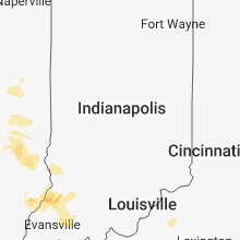
Indiana
| Local Time | Report Details |
|---|---|
| 2:39 PM EDT | Scattered blown down trees across the northwest quarter of the county. location coordinates are rough. time estimated from radar imager in putnam county IN, 43.3 miles W of Indianapolis, IN |
| 4:26 PM EDT | Storm damage reported in vermillion county IN, 50.4 miles ENE of Mattoon, IL |
| 4:26 PM EDT | One hundred-foot tree was blown down across lambert avenue at the u.s. 41 parke vigo county border. time estimated from rada in vigo county IN, 54.4 miles E of Mattoon, IL |
| 4:32 PM EDT | In the vicinity of county road 880 west and county road 750 north scattered tree limbs were down and a couple trees snapped about halfway their trunks. in the same gene in putnam county IN, 45.8 miles W of Indianapolis, IN |
| 4:32 PM EDT | Approximate locatio in vigo county IN, 52.2 miles E of Mattoon, IL |
| 4:33 PM EDT | Trees down across roads around the neighborhood. power is ou in parke county IN, 55.6 miles W of Indianapolis, IN |
| 4:39 PM EDT | About 1 mile north of morton... a large tree was blown down facing south... and corn was blown down facing east about one tenth of a mile away from the tree... suggesti in putnam county IN, 42.1 miles W of Indianapolis, IN |
| 4:47 PM EDT | One tree or large branch blown down in greencastle. location approximate. time based on radar. report received via twitte in putnam county IN, 37.8 miles WSW of Indianapolis, IN |
| 5:08 PM EDT | Large tree down on state road 39 in danville. location coordinates are approximate. time is estimated from radar imager in hendricks county IN, 20.2 miles W of Indianapolis, IN |
| 5:08 PM EDT | Corrects previous tstm wnd dmg report from 2 ssw clayton. six-inch diameter tree limb blown down at county road 100 west and u.s. 40. time adjusted based on rada in hendricks county IN, 22.1 miles WSW of Indianapolis, IN |
| 5:16 PM EDT | Six to eight-inch diameter section of moderate size tree split off. time estimated from radar. received via webmaster e-mai in hendricks county IN, 13.4 miles W of Indianapolis, IN |
| 5:20 PM EDT | Six-inch diameter tree limb blown down at county road 100 west and u.s. 4 in hendricks county IN, 22.1 miles WSW of Indianapolis, IN |
| 5:49 PM EDT | Quarter sized hail reported near Decker, IN, 37.5 miles N of Evansville, IN, location is approximate. relayed by amateur radio. |
| 4:50 PM CDT | Quarter sized hail reported near Hazleton, IN, 35.4 miles N of Evansville, IN, lasted until about 600 pm. reported received via twitter. |
| 5:00 PM CDT | Quarter sized hail reported near Hazleton, IN, 35.4 miles N of Evansville, IN |
| 6:06 PM EDT | Tree branches and... or... trees down on u.s. 36. location is approximate. time is based on radar imager in hendricks county IN, 23.4 miles W of Indianapolis, IN |
| 7:37 PM EDT | Over 100 customers without electrical powe in pike county IN, 32 miles NE of Evansville, IN |
| 7:19 PM CDT | Two electrical transformers have blown causing power outages across portions of southeast evansville... near the angel mounds area. wind gusts estimated 30 to 40 mp in vanderburgh county IN, 1.3 miles E of Evansville, IN |
Virginia
| Local Time | Report Details |
|---|---|
| 2:42 PM EDT | Tree down on middle valley road in franklin county VA, 14.3 miles SE of Roanoke, VA |
| 2:42 PM EDT | Tree down on lost mountain road. time radar estimate in franklin county VA, 15.2 miles SE of Roanoke, VA |
| 3:00 PM EDT | Quarter sized hail reported near Hardy, VA, 15.6 miles SE of Roanoke, VA, various sizes... but largest estimated to be quarter size. time radar estimated. |
| 3:00 PM EDT | Multiple trees down along brooks mill roa in franklin county VA, 16.3 miles SE of Roanoke, VA |
| 3:06 PM EDT | Tree down on big oak lane in franklin county VA, 18.8 miles SE of Roanoke, VA |
| 3:10 PM EDT | Large tree down on 100 block of summit church roa in rockingham county VA, 64.3 miles SE of Elkins, WV |
| 3:38 PM EDT | Tree down on lowesville road off of route 60 in amherst county VA, 51.8 miles ENE of Roanoke, VA |
| 3:48 PM EDT | Tree down at stonehouse lake in amherst county VA, 53.3 miles ENE of Roanoke, VA |
| 3:53 PM EDT | Tree down on house on crattan hill roa in augusta county VA, 63 miles SE of Elkins, WV |
| 4:05 PM EDT | Trees down on garth rd in albemarle county VA, 61.5 miles NW of Richmond, VA |
| 4:12 PM EDT | Trees down along monacan trail rd in albemarle county VA, 60.8 miles NW of Richmond, VA |
| 4:12 PM EDT | Multiple reports of trees down throughout the city of charlottesville in city of charlottes county VA, 59 miles NW of Richmond, VA |
| 5:00 PM EDT | Tree down blocking hebron roa in carroll county VA, 65.2 miles SW of Roanoke, VA |
| 5:00 PM EDT | Tree down blocking tower roa in carroll county VA, 67.8 miles SW of Roanoke, VA |
| 5:00 PM EDT | Multiple trees down along brooks mill roa in franklin county VA, 16.3 miles SE of Roanoke, VA |
| 5:34 PM EDT | Several trees down across shawsville pike in floyd county VA, 20.4 miles SW of Roanoke, VA |
| 6:02 PM EDT | Several trees down across shawsville pike in floyd county VA, 20.4 miles SW of Roanoke, VA |
| 8:30 PM EDT | Tree down on hamilton blvd near parker av in halifax county VA, 65.2 miles NNW of Raleigh, NC |
| 8:42 PM EDT | Three trees reported down over us 58 near calvary road in halifax county VA, 61.4 miles NNW of Raleigh, NC |
| 9:30 PM EDT | Numerous trees down on rt 92 and route 47 between 930 pm and 1000 p in mecklenburg county VA, 65.6 miles SW of Richmond, VA |
Georgia
| Local Time | Report Details |
|---|---|
| 2:59 PM EDT | A tree was blown down on abbottsford rd... south of abbottsford near west point lak in troup county GA, 33.1 miles NNE of Auburn, AL |
| 3:00 PM EDT | One tree fell down and blocked several lanes on i-20 eb... sr 70/fulton in fulton count in fulton county GA, 8.1 miles W of Atlanta, GA |
| 3:15 PM EDT | A radar indicated downburst in western coweta county blew down 2 trees near bud davis rd and hewlette south rd. the trees fell onto a powerpole which then caught fir in coweta county GA, 41.5 miles SW of Atlanta, GA |
| 4:30 PM EDT | Report of a tree blocking the road on ga 219 between ga 315 and ga 116 around the vicinity of mountain hill road in harris count in harris county GA, 27.1 miles ENE of Auburn, AL |
| 7:12 PM EDT | The storm that moved through hall county resulted in several trees down along lights ferry rd at aqualand marina. a marina dock also became seperated with nearly 20 peo in hall county GA, 39.4 miles NE of Atlanta, GA |
Mississippi
| Local Time | Report Details |
|---|---|
| 3:48 PM CDT | A couple trees down around ellisville and laurel. estimated wind gust of 40-50 mph from volunteer firema in jones county MS, 75.1 miles SE of Jackson, MS |
Alabama
| Local Time | Report Details |
|---|---|
| 4:36 PM CDT | Multiple trees down along state route 69 near tallahatta springs rd in northwestern clarke county. time estimated from radar dat in clarke county AL, 40.8 miles W of Camden, AL |
| 5:38 PM CDT | Some minor damage to residence and vehicle due to thunderstorm winds off perry's chapel rd in clarke count in clarke county AL, 44.3 miles SW of Camden, AL |
| 6:45 PM CDT | Trees were blown down onto a shed on highway 159... south of fayett in fayette county AL, 57.9 miles ENE of Starkville, MS |
Texas
| Local Time | Report Details |
|---|---|
| 5:00 PM CDT | Numerous trees and power lines dow in smith county TX, 64.4 miles NNW of Lufkin, TX |
| 5:45 PM CDT | West texas mesonet in crosby county TX, 39.8 miles E of Lubbock, TX |
| 9:57 PM CDT | Storm damage reported in haskell county TX, 62.3 miles N of Abilene, TX |
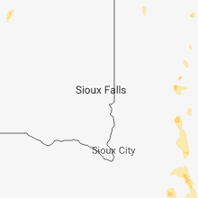
South Dakota
| Local Time | Report Details |
|---|---|
| 5:06 PM MDT | Golf Ball sized hail reported near Buffalo, SD, 87 miles N of Rapid City, SD |
| 5:15 PM MDT | Hen Egg sized hail reported near Newell, SD, 81.5 miles N of Rapid City, SD |
| 5:20 PM MDT | Quarter sized hail reported near Nemo, SD, 24.1 miles WNW of Rapid City, SD |
| 5:22 PM MDT | Baseball sized hail reported near Buffalo, SD, 84.2 miles N of Rapid City, SD, windshield broken by wind driven baseball size hail |
| 5:35 PM MDT | Quarter sized hail reported near Hill City, SD, 21 miles WSW of Rapid City, SD |
| 6:14 PM MDT | Quarter sized hail reported near Rapid City, SD, 1.5 miles SSW of Rapid City, SD |
| 6:15 PM MDT | Hen Egg sized hail reported near Rapid City, SD, 3.4 miles N of Rapid City, SD |
| 6:20 PM MDT | Quarter sized hail reported near Keystone, SD, 15.1 miles SSW of Rapid City, SD |
| 6:38 PM MDT | Quarter sized hail reported near Faith, SD, 76.8 miles NNE of Rapid City, SD |
| 6:55 PM MDT | Quarter sized hail reported near Rapid City, SD, 6.3 miles S of Rapid City, SD |
| 7:26 PM MDT | Storm damage reported in oglala lakota county SD, 82.1 miles SSE of Rapid City, SD |
| 7:49 PM MDT | Hen Egg sized hail reported near Faith, SD, 86.7 miles NE of Rapid City, SD |
| 7:52 PM MDT | Ping Pong Ball sized hail reported near Faith, SD, 78.3 miles NE of Rapid City, SD |
| 7:55 PM MDT | Quarter sized hail reported near Meadow, SD, 106.3 miles SW of Bismarck, ND |
| 10:15 PM MDT | Time estimated from radar in haakon county SD, 45 miles WNW of Pierre, SD |
| 10:34 PM MDT | Storm damage reported in haakon county SD, 44.8 miles WNW of Pierre, SD |
| 10:45 PM MDT | Report from the foster bay rwi in stanley county SD, 43.6 miles WNW of Pierre, SD |
| 1:14 AM CDT | Storm damage reported in faulk county SD, 45.8 miles WSW of Aberdeen, SD |
| 1:30 AM CDT | Reports of tree branches down. half of the town of faulkton was without power. time estimate in faulk county SD, 43.1 miles SW of Aberdeen, SD |
| 2:35 AM CDT | Storm damage reported in todd county SD, 24.5 miles NNW of Valentine, NE |
| 3:13 AM CDT | Storm damage reported in tripp county SD, 50.6 miles NE of Valentine, NE |
| 3:21 AM CDT | Storm damage reported in tripp county SD, 43.1 miles NE of Valentine, NE |
North Dakota
| Local Time | Report Details |
|---|---|
| 6:43 PM CDT | Quarter sized hail reported near Flaxton, ND, 68 miles NW of Minot, ND, very heavy rainfall also occurring at time of report. |
| 6:43 PM CDT | Heavy rainfall also occurring at time of repor in burke county ND, 68 miles NW of Minot, ND |
| 5:57 PM MDT | Quarter sized hail reported near Reeder, ND, 104.9 miles WSW of Bismarck, ND |
| 6:14 PM MDT | Quarter sized hail reported near Halliday, ND, 77.6 miles SW of Minot, ND, quarter size hail falling at the time of report. |
| 7:15 PM CDT | Golf Ball sized hail reported near Parshall, ND, 43.5 miles WSW of Minot, ND, golf ball size hail. time estimated based on radar. public report relayed by local broadcast media. |
| 6:16 PM MDT | Quarter sized hail reported near Regent, ND, 88.9 miles WSW of Bismarck, ND, time of report is estimated based on radar data. report given on twitter. |
| 7:30 PM CDT | Winds sustained at 40 mph... gusting to 58 mph at time of repor in mountrail county ND, 33.9 miles WSW of Minot, ND |
| 9:58 PM CDT | Storm damage reported in morton county ND, 5.8 miles WSW of Bismarck, ND |
Nebraska
| Local Time | Report Details |
|---|---|
| 8:00 PM MDT | Ping Pong Ball sized hail reported near Gordon, NE, 91.6 miles W of Valentine, NE |
| 2:33 AM CDT | Storm damage reported in cherry county NE, 0.3 miles S of Valentine, NE |
North Carolina
| Local Time | Report Details |
|---|---|
| 11:40 PM EDT | Tree on a house at 123 priestly creek d in orange county NC, 25.5 miles WNW of Raleigh, NC |
| 11:40 PM EDT | Tree on a house at 115 bruton d in orange county NC, 27.5 miles WNW of Raleigh, NC |
| 11:40 PM EDT | Tree down at hatch rd. and warren c in orange county NC, 27.6 miles WNW of Raleigh, NC |
| 11:45 PM EDT | Tree down at mt. moriah rd. and erwin r in orange county NC, 24.2 miles WNW of Raleigh, NC |
| 11:46 PM EDT | Power lines dow in durham county NC, 24.1 miles NW of Raleigh, NC |
Iowa
| Local Time | Report Details |
|---|---|
| 11:58 PM CDT | Trees and power lines down in creston. time estimated from rada in union county IA, 53.3 miles SW of Des Moines, IA |
| 12:05 AM CDT | Measured at iowa dot rwis sit in union county IA, 51.9 miles SW of Des Moines, IA |
| 12:05 AM CDT | Reported at creston airpor in union county IA, 55.2 miles SW of Des Moines, IA |
| 1:21 AM CDT | Reported at lamoni airpor in decatur county IA, 67.9 miles SSW of Des Moines, IA |
Connect with Interactive Hail Maps