

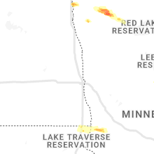
Hail Map for Sunday, June 12, 2022

Number of Impacted Households on 6/12/2022
0
Impacted by 1" or Larger Hail
0
Impacted by 1.75" or Larger Hail
0
Impacted by 2.5" or Larger Hail
Square Miles of Populated Area Impacted on 6/12/2022
0
Impacted by 1" or Larger Hail
0
Impacted by 1.75" or Larger Hail
0
Impacted by 2.5" or Larger Hail


Cities Most Affected by Hail Storms of 6/12/2022
| Hail Size | Demographics of Zip Codes Affected | ||||||
|---|---|---|---|---|---|---|---|
| City | Count | Average | Largest | Pop Density | House Value | Income | Age |
| Sturgis, SD | 3 | 1.83 | 2.00 | 15 | $79k | $34.9k | 44.7 |
| Wall, SD | 1 | 4.50 | 4.50 | 1 | $63k | $36.2k | 43.8 |
| Belle Fourche, SD | 1 | 4.00 | 4.00 | 6 | $67k | $30.1k | 39.3 |
| Aladdin, WY | 1 | 2.75 | 2.75 | 1 | $189k | $15.0k | 55.4 |
| Saint Onge, SD | 1 | 2.75 | 2.75 | 6 | $50k | $25.7k | 46.4 |
| Cayuga, IN | 1 | 2.00 | 2.00 | 27 | $58k | $34.6k | 45.3 |
| Girard, IL | 1 | 2.00 | 2.00 | 48 | $72k | $37.2k | 45.3 |
| Newfolden, MN | 1 | 1.75 | 1.75 | 7 | $49k | $33.2k | 38.6 |
| Wasta, SD | 1 | 1.75 | 1.75 | 1 | $26k | $26.4k | 38.0 |
| Hulett, WY | 1 | 1.75 | 1.75 | 1 | $64k | $28.0k | 43.7 |
| Whitewood, SD | 1 | 1.75 | 1.75 | 10 | $70k | $33.8k | 44.9 |
| Owanka, SD | 1 | 1.75 | 1.75 | 1 | $125k | $80.0k | 43.8 |
Hail and Wind Damage Spotted on 6/12/2022
Filter by Report Type:Hail ReportsWind Reports
States Impacted
Illinois, Nebraska, Minnesota, Kansas, Indiana, Virginia, North Carolina, Ohio, Wyoming, Colorado, South Dakota, Idaho, TexasIllinois
| Local Time | Report Details |
|---|---|
| 7:09 AM CDT | Quarter sized hail reported near Roseville, IL, 56.4 miles W of Peoria, IL, delayed report. time estimated from radar. also report of crop and tree damage. |
| 7:40 AM CDT | Ping Pong Ball sized hail reported near Urbana, IL, 44.9 miles N of Mattoon, IL |
| 7:40 AM CDT | Tree damage on leverett roa in champaign county IL, 49.4 miles NNE of Mattoon, IL |
| 7:40 AM CDT | Damage to grain elevator. winds estimated at 60mph. corner of leverett road and county road 135 in champaign county IL, 49.7 miles N of Mattoon, IL |
| 7:40 AM CDT | Outbuilding destroye in champaign county IL, 49.6 miles N of Mattoon, IL |
| 7:55 AM CDT | Quarter sized hail reported near Saint Joseph, IL, 46.9 miles NNE of Mattoon, IL, quarter size hail just north of town. |
| 8:08 AM CDT | Part of barn roof blown off. report relayed by broadcast media. time of the event is estimated using rada in mcdonough county IL, 59 miles E of Kahoka, MO |
| 8:09 AM CDT | Pine tree snapped half way up... time estimated from rada in mcdonough county IL, 59 miles E of Kahoka, MO |
| 8:50 AM CDT | 6 inch limb down. time estimated from rada in vermilion county IL, 52.1 miles NE of Mattoon, IL |
| 9:30 AM CDT | Wind estimate based off of remote tree damage assessment from pictures and vide in morgan county IL, 64.4 miles N of Saint Louis, MO |
| 9:30 AM CDT | Ping Pong Ball sized hail reported near Franklin, IL, 64.4 miles N of Saint Louis, MO, nearby crops beaten down... skylight knocked out. relayed via weather channel storm chaser. |
| 10:00 AM CDT | Sheriffs office in macoupin county reported trees down in the otter lake area west of girar in macoupin county IL, 58.8 miles NNE of Saint Louis, MO |
| 10:12 AM CDT | Quarter sized hail reported near Girard, IL, 58.9 miles NNE of Saint Louis, MO, photo of oblong quarter-size hail sent to media partner. |
| 10:24 AM CDT | Several trees uprooted/snapped near intersection of kirkland and sumter roads. time estimated from radar. facebook repor in macoupin county IL, 51.2 miles NNE of Saint Louis, MO |
| 10:25 AM CDT | Camper flipped over on route 108 near atwater road. time estimated from radar. facebook repor in macoupin county IL, 51.6 miles NNE of Saint Louis, MO |
| 10:25 AM CDT | Half Dollar sized hail reported near Modesto, IL, 60 miles N of Saint Louis, MO, twitter report sent at 10:25. |
| 10:25 AM CDT | Ping Pong Ball sized hail reported near Modesto, IL, 60 miles N of Saint Louis, MO, corrects previous hail report from modesto. twitter report sent at 10:25. |
| 10:25 AM CDT | Pictures via twitter of multiple small to medium-size trees snapped. noted that the tree damage was in a narrow are in macoupin county IL, 52 miles NNE of Saint Louis, MO |
| 10:25 AM CDT | Hen Egg sized hail reported near Girard, IL, 56.9 miles NNE of Saint Louis, MO, via facebook picture--damage to car windshield. |
| 10:28 AM CDT | Tree down blocking route 108 one mile east of standard city r in macoupin county IL, 50.1 miles NNE of Saint Louis, MO |
| 10:28 AM CDT | Corrects previous tstm wnd dmg report from 4 sw atwater. corrects previous tstm wnd dmg report from 4 sw atwater. several trees uprooted/snapped near intersection of ki in macoupin county IL, 51.2 miles NNE of Saint Louis, MO |
| 10:29 AM CDT | Corrects previous tstm wnd dmg report from 4 s atwater. camper flipped over on route 108 near atwater road. time estimated from radar. facebook repor in macoupin county IL, 51.6 miles NNE of Saint Louis, MO |
| 10:29 AM CDT | Machine shed destroyed on dickey road... with debris blown approximately a 1/4 mile to the east/southeast. winds estimated to be 60-70 mph. time estimated from rada in macoupin county IL, 50.7 miles NNE of Saint Louis, MO |
| 10:29 AM CDT | Power poles down on barnett road between leefers and south atwater roads. time estimated from rada in macoupin county IL, 50.8 miles NNE of Saint Louis, MO |
| 10:30 AM CDT | Macoupin county sheriffs office reported trees down east of carlinville. time estimated from rada in macoupin county IL, 49.9 miles NNE of Saint Louis, MO |
| 10:43 AM CDT | Quarter sized hail reported near Litchfield, IL, 47 miles NE of Saint Louis, MO |
| 10:45 AM CDT | Quarter sized hail reported near Litchfield, IL, 47.9 miles NE of Saint Louis, MO |
Nebraska
| Local Time | Report Details |
|---|---|
| 7:10 AM CDT | Mesonet report from earlie in fillmore county NE, 60 miles SE of Grand Island, NE |
| 7:15 AM CDT | From a personal weather statio in jefferson county NE, 65 miles SE of Grand Island, NE |
| 4:17 PM MDT | Ping Pong Ball sized hail reported near Morrill, NE, 18.1 miles NW of Scottsbluff, NE |
| 4:31 PM MDT | Spotter estimated wind gusts of 50 to 60 mp in scotts bluff county NE, 19.9 miles WNW of Scottsbluff, NE |
| 4:45 PM MDT | Wind damage to trees and a building on spring creek road in mitchell. social media pos in scotts bluff county NE, 8.9 miles NW of Scottsbluff, NE |
| 5:14 PM MDT | Ping Pong Ball sized hail reported near Mitchell, NE, 7.9 miles NNW of Scottsbluff, NE, hail ended at 530 pm. |
| 6:36 PM MDT | 63 knot gust from the southeas in box butte county NE, 46 miles ENE of Scottsbluff, NE |
| 7:10 PM MDT | Storm damage reported in sheridan county NE, 77.3 miles ENE of Scottsbluff, NE |
| 7:26 PM MDT | Estimated thunderstorm wind gust of 60 plus miles per hour in sheridan county NE, 71 miles ENE of Scottsbluff, NE |
| 12:01 AM CDT | Storm damage reported in nuckolls county NE, 50.7 miles SSE of Grand Island, NE |
| 12:15 AM CDT | Facebook... time estimated from rada in nuckolls county NE, 64 miles SSE of Grand Island, NE |
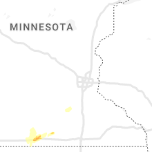
Minnesota
| Local Time | Report Details |
|---|---|
| 8:01 AM CDT | Quarter sized hail reported near Warren, MN, 62 miles SW of Roseau, MN, corrects previous hail report from 5 ssw radium. corrects previous hail report from 5 ssw radium. corrects previous report due to error in time. |
| 11:22 AM CDT | Quarter sized hail reported near Warren, MN, 62 miles SW of Roseau, MN |
| 3:53 PM CDT | Golf Ball sized hail reported near Newfolden, MN, 39.2 miles SSW of Roseau, MN, deputy reported golf ball sized hail at the cross roads of highway 32 and county road 28. |
| 4:07 PM CDT | Ping Pong Ball sized hail reported near Middle River, MN, 35.8 miles SSW of Roseau, MN, quarter to ping pong sized hail reported by trained weather spotter. hail was accumulating on ground. |
| 4:07 PM CDT | Trained weather spotter reported 65mph wind gusts 7.5 miles northeast of hol in marshall county MN, 35.8 miles SSW of Roseau, MN |
Kansas
| Local Time | Report Details |
|---|---|
| 9:12 AM CDT | Quarter sized hail reported near Seneca, KS, 51.8 miles NNE of Manhattan, KS, mostly pea to half inch hail with a few around quarter size. |
| 6:55 PM CDT | Johnson city airport awo in stanton county KS, 55.3 miles WSW of Garden City, KS |
| 6:15 PM MDT | Storm damage reported in hamilton county KS, 47.9 miles W of Garden City, KS |
| 8:30 PM CDT | Truck blown off road east of ingalls... reported by public on social media (photo in gray county KS, 26.3 miles ESE of Garden City, KS |
| 8:32 PM CDT | Truck and camper blown over just south of the scott finney county line. relayed by scott county sheriffs offic in finney county KS, 20.1 miles N of Garden City, KS |
| 9:10 PM CDT | Kansas mesonet. wind gust of 50 mph at 2m elevation... 59 mph at 10m elevatio in logan county KS, 36.2 miles SSW of Colby, KS |
| 9:17 PM CDT | Delayed report... report on social media of measured 63 mph gust east of russel springs and south of oakley. video with post showed near zero visibility in blowing dust in logan county KS, 36.5 miles SSE of Colby, KS |
| 9:24 PM CDT | Corrects previous tstm wnd gst report from 9 nnw the monument rocks. delayed report... report on social media of measured 63 mph gust east of russel springs and south o in logan county KS, 36.5 miles SSE of Colby, KS |
| 9:40 PM CDT | Storm damage reported in gove county KS, 43.9 miles SE of Colby, KS |
| 12:01 AM CDT | Power pole caught on fire from arcing power line in jewell county KS, 78.5 miles S of Grand Island, NE |
Indiana
| Local Time | Report Details |
|---|---|
| 10:35 AM EDT | Hen Egg sized hail reported near Cayuga, IN, 58.5 miles NE of Mattoon, IL |
| 12:08 PM EDT | Late reports of several trees downed along us highway 231 between fincastle and county road 900 north. numerous branches and limbs downed onto highway. time estimated f in putnam county IN, 40 miles W of Indianapolis, IN |
Virginia
| Local Time | Report Details |
|---|---|
| 10:50 AM EDT | Trees down in the area of three chopt road and cary stree in city of richmond county VA, 8.9 miles NE of Richmond, VA |
| 10:55 AM EDT | Numerous trees down across the central part of henrico count in henrico county VA, 13.3 miles NE of Richmond, VA |
| 11:00 AM EDT | Trees down on powerlines on the north side of richmon in city of richmond county VA, 12 miles ENE of Richmond, VA |
| 11:30 AM EDT | Numerous trees down throughout the county. time estimated by rada in new kent county VA, 28.1 miles E of Richmond, VA |
| 12:03 PM EDT | Tree down near courthouse rd and prince george driv in prince george county VA, 28.6 miles SE of Richmond, VA |
| 12:18 PM EDT | Tree down across brockwell roa in prince george county VA, 32.5 miles SE of Richmond, VA |
| 1:26 PM EDT | Mesonet station at thimble shoal in anz632 county VA, 23.2 miles NNW of Virginia Beach, VA |
| 6:53 PM EDT | Multiple trees down around bremo bluf in fluvanna county VA, 38.3 miles WNW of Richmond, VA |
| 7:08 PM EDT | Numerous trees dow in fluvanna county VA, 36 miles WNW of Richmond, VA |
| 7:50 PM EDT | Multiple reports of trees down near clinto in cumberland county VA, 26.4 miles W of Richmond, VA |
| 8:43 PM EDT | Multiple trees and power lines down between jettersville and amelia courthous in amelia county VA, 25.2 miles WSW of Richmond, VA |
| 9:05 PM EDT | Multiple trees down just north of the intersection of namozine and w creek road. time estimate in amelia county VA, 25.9 miles SW of Richmond, VA |
North Carolina
| Local Time | Report Details |
|---|---|
| 2:30 PM EDT | Half Dollar sized hail reported near Jamesville, NC, 83.1 miles SW of Virginia Beach, VA, hail slightly larger than a quarter was reported by the public at inner banks beagles and german shorthair pointers. |
| 3:18 PM EDT | Reported trees down in the city of belhave in beaufort county NC, 88.8 miles SSW of Virginia Beach, VA |
| 3:30 PM EDT | Half Dollar sized hail reported near Jamesville, NC, 83.1 miles SW of Virginia Beach, VA, corrects previous hail report from 4 s jamesville. hail slightly larger than a quarter was reported by the public at inner banks beagles and german shorthair pointers. |
| 4:18 PM EDT | Corrects previous tstm wnd dmg report from belhaven. corrects previous tstm wnd dmg report from belhaven. reported trees down in the city of belhave in beaufort county NC, 88.8 miles SSW of Virginia Beach, VA |
| 4:41 PM EDT | Possible tornado relayed through 911 center. tree blown over and minor damage to vinyl siding at residenc in northampton county NC, 73.5 miles WSW of Virginia Beach, VA |
| 5:04 PM EDT | Trees down on griffintown road and power out in woodlan in northampton county NC, 71.1 miles WSW of Virginia Beach, VA |
| 7:13 PM EDT | Trees down and damage to a barn. caller said the roof was ripped off the barn. pea size hail occurred as well. time estimated based off rada in pitt county NC, 73.3 miles ESE of Raleigh, NC |
| 7:34 PM EDT | Numerous trees down... including several trees down on home in craven county NC, 80.5 miles NNE of Wilmington, NC |
| 7:34 PM EDT | Quarter sized hail reported near Dover, NC, 79.5 miles NNE of Wilmington, NC, delayed report. firefighter reported a significant amount of quarter size hail in addition to strong winds. time estimated based on nearby reports. |
Ohio
| Local Time | Report Details |
|---|---|
| 3:40 PM EDT | Several trees down along wolf hill r in vinton county OH, 56.8 miles SSE of Columbus, OH |
| 5:02 PM EDT | Report of a tree down on state route 707 and now road. time estimated from rada in mercer county OH, 36.4 miles SE of Fort Wayne, IN |
| 5:05 PM EDT | A few trees were blown down along state route 56 near new plymout in vinton county OH, 51.2 miles SE of Columbus, OH |
| 7:27 PM EDT | Several reports of trees down in pike and german townships. time estimated from rada in clark county OH, 49.3 miles W of Columbus, OH |
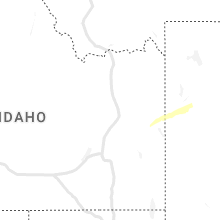
Wyoming
| Local Time | Report Details |
|---|---|
| 3:00 PM MDT | Ping Pong Ball sized hail reported near Recluse, WY, 46.8 miles NNW of Gillette, WY, wind gusts to 41 mph. |
| 3:37 PM MDT | Quarter sized hail reported near Clearmont, WY, 49.5 miles NW of Gillette, WY, pea to quarter size. |
| 3:55 PM MDT | Half Dollar sized hail reported near Torrington, WY, 30.4 miles WNW of Scottsbluff, NE, received photo via facebook. time estimated based on radar. |
| 3:56 PM MDT | Downed power pole at i-80 milepost 386 blocking traffi in laramie county WY, 60.4 miles SW of Scottsbluff, NE |
| 4:13 PM MDT | Golf Ball sized hail reported near Hulett, WY, 54.3 miles NE of Gillette, WY |
| 4:20 PM MDT | Quarter sized hail reported near Wilson, WY, 54.9 miles E of Idaho Falls, ID |
| 4:20 PM MDT | Quarter sized hail reported near Wilson, WY, 54.4 miles E of Idaho Falls, ID, report of large hail denting vehicle hood while driving over teton pass. estimating at least 1 inch diameter hail based on report of damage. |
| 4:22 PM MDT | Local emergency manager forwarded a social media post showing a large pine tree snapped near the base and lying across a road in the town of jackson... wy. diameter of in teton county WY, 64.4 miles E of Idaho Falls, ID |
| 4:24 PM MDT | Storm damage reported in campbell county WY, 3.7 miles NNW of Gillette, WY |
| 4:37 PM MDT | Quarter sized hail reported near Rozet, WY, 19.2 miles NE of Gillette, WY |
| 4:40 PM MDT | Baseball sized hail reported near Aladdin, WY, 62.9 miles NW of Rapid City, SD, mostly golf ball size hail... but a few baseballs |
Colorado
| Local Time | Report Details |
|---|---|
| 4:06 PM MDT | Quarter sized hail reported near Sterling, CO, 29.5 miles NW of Yuma, CO |
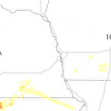
South Dakota
| Local Time | Report Details |
|---|---|
| 4:59 PM MDT | Ping Pong Ball sized hail reported near Belle Fourche, SD, 50.9 miles NW of Rapid City, SD, report from belle fourche fire chief. reports that hail is also getting bigger. |
| 5:00 PM MDT | Grapefruit sized hail reported near Belle Fourche, SD, 53.5 miles NW of Rapid City, SD, wind driven baseball to softball size hail. winds estimated over 75 mph. |
| 5:00 PM MDT | Large tree uprooted in butte county SD, 50.9 miles NW of Rapid City, SD |
| 5:15 PM MDT | Wind gust measured via unl mobile mesonet in rfd in lawrence county SD, 40.4 miles NW of Rapid City, SD |
| 5:26 PM MDT | Baseball sized hail reported near Saint Onge, SD, 43 miles NW of Rapid City, SD, also measured 70 mph wind gust. large branches are down. |
| 5:56 PM MDT | Golf Ball sized hail reported near Whitewood, SD, 33.6 miles NNW of Rapid City, SD |
| 6:30 PM MDT | Half Dollar sized hail reported near Lead, SD, 32.6 miles NW of Rapid City, SD |
| 6:37 PM MDT | Ping Pong Ball sized hail reported near Deadwood, SD, 32.2 miles NW of Rapid City, SD |
| 6:40 PM MDT | Hen Egg sized hail reported near Sturgis, SD, 27.7 miles NNW of Rapid City, SD |
| 6:42 PM MDT | Golf Ball sized hail reported near Sturgis, SD, 26.6 miles NNW of Rapid City, SD |
| 6:44 PM MDT | Golf Ball sized hail reported near Sturgis, SD, 24.8 miles NNW of Rapid City, SD |
| 6:45 PM MDT | Golf Ball sized hail reported near Wasta, SD, 43.5 miles ENE of Rapid City, SD, golf ball sized hail |
| 6:45 PM MDT | Softball sized hail reported near Wall, SD, 51.9 miles ENE of Rapid City, SD |
| 6:47 PM MDT | Half Dollar sized hail reported near Sturgis, SD, 19.6 miles NNW of Rapid City, SD |
| 6:47 PM MDT | Half Dollar sized hail reported near Sturgis, SD, 22.4 miles NNW of Rapid City, SD |
| 7:00 PM MDT | Ping Pong Ball sized hail reported near Sturgis, SD, 24.4 miles NNW of Rapid City, SD |
| 7:02 PM MDT | Quarter sized hail reported near Sturgis, SD, 26.3 miles NNW of Rapid City, SD |
| 7:15 PM MDT | Quarter sized hail reported near Owanka, SD, 34.4 miles ENE of Rapid City, SD |
| 7:33 PM MDT | Quarter sized hail reported near Sturgis, SD, 18.2 miles NNE of Rapid City, SD |
| 7:41 PM MDT | Storm damage reported in pennington county SD, 36.4 miles E of Rapid City, SD |
| 7:51 PM MDT | Storm damage reported in pennington county SD, 36.4 miles E of Rapid City, SD |
| 8:03 PM MDT | Golf Ball sized hail reported near Owanka, SD, 34.4 miles ENE of Rapid City, SD |
| 8:16 PM MDT | Storm damage reported in jackson county SD, 72.3 miles ESE of Rapid City, SD |
| 8:20 PM MDT | Storm damage reported in jackson county SD, 69.3 miles E of Rapid City, SD |
| 10:15 PM CDT | Semi tractor trailer blown over on interstate 9 in jones county SD, 47.9 miles SW of Pierre, SD |
| 10:20 PM CDT | Semi tractor trailer blown over on interstate 9 in jones county SD, 42.7 miles SW of Pierre, SD |
| 10:28 PM MDT | Storm damage reported in harding county SD, 106 miles N of Rapid City, SD |
| 10:41 PM MDT | Storm damage reported in harding county SD, 91 miles N of Rapid City, SD |
| 10:45 PM MDT | Storm damage reported in harding county SD, 99.4 miles N of Rapid City, SD |
| 10:50 PM MDT | Storm damage reported in butte county SD, 61.7 miles NNW of Rapid City, SD |
| 10:56 PM MDT | Report from mping: 1-inch tree limbs broken; shingles blown of in stanley county SD, 4.7 miles NNW of Pierre, SD |
| 10:58 PM MDT | Storm damage reported in butte county SD, 68.8 miles N of Rapid City, SD |
| 11:59 PM CDT | Mesonet station 54 reliance (sddot in lyman county SD, 53.2 miles SE of Pierre, SD |
| 12:01 AM CDT | Mesonet station 212 sd rwis aga in potter county SD, 39 miles NNE of Pierre, SD |
| 12:05 AM CDT | Storm damage reported in lyman county SD, 60.7 miles SE of Pierre, SD |
| 12:06 AM CDT | Storm damage reported in gregory county SD, 64.9 miles ENE of Valentine, NE |
| 12:07 AM CDT | Asos station kpir pierre muni a in hughes county SD, 3.6 miles ENE of Pierre, SD |
| 12:09 AM CDT | Personal weather statio in brule county SD, 63.3 miles SE of Pierre, SD |
| 12:11 AM CDT | Storm damage reported in charles mix county SD, 68.7 miles NNW of Oneill, NE |
| 12:59 AM CDT | Personal weather statio in aurora county SD, 86.9 miles N of Oneill, NE |
| 12:04 AM MDT | Storm damage reported in meade county SD, 88.7 miles NE of Rapid City, SD |
| 1:15 AM CDT | Storm damage reported in davison county SD, 71.9 miles W of Sioux Falls, SD |
| 1:15 AM CDT | Storm damage reported in jerauld county SD, 91.9 miles WNW of Sioux Falls, SD |
| 1:20 AM CDT | Storm damage reported in jerauld county SD, 91.9 miles WNW of Sioux Falls, SD |
| 1:29 AM CDT | Storm damage reported in davison county SD, 65.3 miles W of Sioux Falls, SD |
| 1:02 AM MDT | Mesonet station 178 trail city (sddot in corson county SD, 79.3 miles NNW of Pierre, SD |
| 2:26 AM CDT | Storm damage reported in kingsbury county SD, 55.8 miles NNW of Sioux Falls, SD |
Idaho
| Local Time | Report Details |
|---|---|
| 6:42 PM MDT | Mesonet station pcki1 pole cree in owyhee county ID, 75.5 miles WSW of Twin Falls, ID |
Texas
| Local Time | Report Details |
|---|---|
| 8:29 PM CDT | Storm damage reported in hutchinson county TX, 42.4 miles NE of Amarillo, TX |
| 8:49 PM CDT | Storm damage reported in deaf smith county TX, 41.4 miles SW of Amarillo, TX |
| 8:55 PM CDT | Storm damage reported in hutchinson county TX, 41.3 miles NE of Amarillo, TX |
| 8:55 PM CDT | Corrects previous tstm wnd gst report from 2 n borge in hutchinson county TX, 41.3 miles NE of Amarillo, TX |
Connect with Interactive Hail Maps