

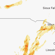
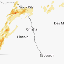
Hail Map for Saturday, June 14, 2014

Number of Impacted Households on 6/14/2014
0
Impacted by 1" or Larger Hail
0
Impacted by 1.75" or Larger Hail
0
Impacted by 2.5" or Larger Hail
Square Miles of Populated Area Impacted on 6/14/2014
0
Impacted by 1" or Larger Hail
0
Impacted by 1.75" or Larger Hail
0
Impacted by 2.5" or Larger Hail


Cities Most Affected by Hail Storms of 6/14/2014
| Hail Size | Demographics of Zip Codes Affected | ||||||
|---|---|---|---|---|---|---|---|
| City | Count | Average | Largest | Pop Density | House Value | Income | Age |
| Colby, KS | 7 | 2.25 | 3.00 | 13 | $79k | $37.3k | 35.7 |
| Kanorado, KS | 5 | 2.35 | 2.75 | 1 | $51k | $26.9k | 48.3 |
| Gibbon, NE | 3 | 2.33 | 2.75 | 13 | $79k | $36.5k | 37.3 |
| Hastings, NE | 3 | 2.17 | 2.75 | 184 | $78k | $36.9k | 37.0 |
| Goodland, KS | 3 | 2.08 | 2.75 | 9 | $65k | $33.1k | 41.5 |
| Limon, CO | 3 | 1.75 | 1.75 | 2 | $88k | $35.1k | 38.2 |
| Ludell, KS | 2 | 2.63 | 2.75 | 2 | $15k | $38.1k | 52.2 |
| Fullerton, NE | 2 | 2.25 | 2.75 | 5 | $44k | $30.6k | 46.9 |
| Atwood, KS | 2 | 2.25 | 2.75 | 4 | $49k | $32.6k | 50.7 |
| Arapahoe, NE | 2 | 2.25 | 2.75 | 6 | $45k | $29.4k | 46.4 |
| Saint Francis, KS | 1 | 4.00 | 4.00 | 2 | $50k | $31.4k | 51.1 |
| Englewood, CO | 2 | 1.88 | 2.00 | 3129 | $75k | $20.5k | 37.6 |
| Grand Island, NE | 2 | 1.75 | 1.75 | 265 | $91k | $38.6k | 39.6 |
| Glade, KS | 2 | 1.75 | 1.75 | 3 | $27k | $38.5k | 46.3 |
| Albion, NE | 2 | 1.75 | 1.75 | 9 | $65k | $32.9k | 45.5 |
| Holdrege, NE | 2 | 1.75 | 1.75 | 30 | $72k | $37.2k | 43.2 |
| Lusk, WY | 2 | 1.75 | 1.75 | 0 | $63k | $30.4k | 44.7 |
| Wakeeney, KS | 2 | 1.75 | 1.75 | 7 | $49k | $30.4k | 49.0 |
| Ayr, NE | 1 | 2.75 | 2.75 | 6 | $60k | $39.6k | 44.8 |
| Rexford, KS | 1 | 2.75 | 2.75 | 1 | $30k | $39.4k | 38.5 |
| Ashton, NE | 1 | 2.00 | 2.00 | 2 | $31k | $31.1k | 47.6 |
| Jetmore, KS | 1 | 2.00 | 2.00 | 2 | $48k | $34.5k | 43.8 |
| Edson, KS | 1 | 1.75 | 1.75 | 1 | $84k | $30.4k | 48.7 |
| Ravenna, NE | 1 | 1.75 | 1.75 | 11 | $53k | $31.4k | 43.3 |
| Funk, NE | 1 | 1.75 | 1.75 | 3 | $82k | $34.8k | 45.0 |
| Oxford, NE | 1 | 1.75 | 1.75 | 3 | $40k | $32.2k | 45.5 |
| Oberlin, KS | 1 | 1.75 | 1.75 | 5 | $49k | $31.7k | 50.5 |
| Harrisburg, SD | 1 | 1.75 | 1.75 | 118 | $119k | $51.4k | 28.6 |
| Trumbull, NE | 1 | 1.75 | 1.75 | 9 | $72k | $41.6k | 40.0 |
| Cimarron, KS | 1 | 1.75 | 1.75 | 2 | $80k | $40.2k | 34.1 |
| Bird City, KS | 1 | 1.75 | 1.75 | 1 | $43k | $27.5k | 46.6 |
Hail and Wind Damage Spotted on 6/14/2014
Filter by Report Type:Hail ReportsWind Reports
States Impacted
South Dakota, Kansas, Florida, Colorado, Iowa, Georgia, Wyoming, Nebraska, Minnesota, Texas, Oklahoma, MissouriSouth Dakota
| Local Time | Report Details |
|---|---|
| 6:20 AM MDT | Quarter sized hail reported near Scenic, SD, 42.8 miles ESE of Rapid City, SD |
| 6:20 AM MDT | Storm damage reported in pennington county SD, 42.8 miles ESE of Rapid City, SD |
| 6:48 AM MDT | Pinnacles raws in pennington county SD, 51.3 miles ESE of Rapid City, SD |
| 7:10 AM MDT | Camper flipped at mile marker 120 on interstate 9 in pennington county SD, 59.6 miles E of Rapid City, SD |
| 8:00 AM MDT | Storm damage reported in haakon county SD, 63.1 miles WSW of Pierre, SD |
| 10:35 AM MDT | Storm damage reported in jackson county SD, 73.1 miles SW of Pierre, SD |
| 11:20 AM MDT | Storm damage reported in haakon county SD, 44 miles WSW of Pierre, SD |
| 12:45 PM CDT | Ping Pong Ball sized hail reported near Vivian, SD, 38.6 miles S of Pierre, SD, ping pong hail. |
| 6:45 PM CDT | Ping Pong Ball sized hail reported near Mission Hill, SD, 53.2 miles SSW of Sioux Falls, SD |
| 7:26 PM CDT | Quarter sized hail reported near Canton, SD, 18.6 miles SSE of Sioux Falls, SD |
| 7:30 PM MDT | Storm damage reported in fall river county SD, 72.9 miles SSW of Rapid City, SD |
| 8:55 PM CDT | Golf Ball sized hail reported near Harrisburg, SD, 8.1 miles S of Sioux Falls, SD |
Kansas
| Local Time | Report Details |
|---|---|
| 11:57 AM CDT | 6 to 7 inch diameter tree limbs blown dow in republic county KS, 68.2 miles SSE of Grand Island, NE |
| 6:00 PM CDT | Golf Ball sized hail reported near Glade, KS, 55.9 miles N of Hays, KS, public report of golf ball sized hail e and ne of glade. |
| 6:07 PM CDT | Golf Ball sized hail reported near Glade, KS, 58 miles N of Hays, KS, report received via web entry. |
| 6:33 PM CDT | Quarter sized hail reported near Kensington, KS, 57 miles NNE of Hays, KS, hail covering the ground. report rcvd via web entry. |
| 6:58 PM CDT | Quarter sized hail reported near Athol, KS, 62.6 miles NNE of Hays, KS, hail did not last long. largest was quarter size. |
| 7:58 PM CDT | Storm damage reported in cheyenne county KS, 42.7 miles ESE of Yuma, CO |
| 6:59 PM MDT | Baseball sized hail reported near Kanorado, KS, 49 miles W of Colby, KS, hail size ranged from golf ball to baseball size. |
| 7:00 PM MDT | Hen Egg sized hail reported near Kanorado, KS, 53.4 miles W of Colby, KS, 2.00 inch hail reported by the fire chief in kanorado. report relayed by law enforcement. |
| 7:02 PM MDT | Tennis Ball sized hail reported near Kanorado, KS, 53.4 miles W of Colby, KS |
| 8:06 PM CDT | Storm damage reported in cheyenne county KS, 44.1 miles ESE of Yuma, CO |
| 7:07 PM MDT | Baseball sized hail reported near Kanorado, KS, 53.4 miles W of Colby, KS |
| 7:12 PM MDT | Golf Ball sized hail reported near Kanorado, KS, 53.4 miles W of Colby, KS, golf ball size hail and strong winds causing blowing dust and visibility less than a quarter mile. |
| 7:12 PM MDT | Grain bins leveled from wind and baseball size hai in sherman county KS, 53.7 miles W of Colby, KS |
| 8:15 PM CDT | Storm damage reported in cheyenne county KS, 47.8 miles WNW of Colby, KS |
| 7:15 PM MDT | Delayed report of several large trees down and golf ball size hail near road 76 and road 8. time estimated by rada in sherman county KS, 47.4 miles W of Colby, KS |
| 7:17 PM MDT | Also quarter size hai in sherman county KS, 47.5 miles W of Colby, KS |
| 8:18 PM CDT | Storm damage reported in cheyenne county KS, 44.1 miles ESE of Yuma, CO |
| 7:19 PM MDT | Golf Ball sized hail reported near Goodland, KS, 40.6 miles W of Colby, KS, mostly nickel size hail. some golf ball size. also measured 55 mph wind. |
| 7:20 PM MDT | Golf Ball sized hail reported near Goodland, KS, 37.9 miles W of Colby, KS, golf ball size hail on 24 west of goodland. |
| 8:20 PM CDT | Grapefruit sized hail reported near Saint Francis, KS, 37.5 miles WNW of Colby, KS, delayed report received from spotter network. |
| 7:21 PM MDT | Baseball sized hail reported near Goodland, KS, 35.8 miles W of Colby, KS, baseball size hail at the nws office. |
| 8:24 PM CDT | Storm damage reported in cheyenne county KS, 47.8 miles WNW of Colby, KS |
| 7:24 PM MDT | 60 mph wind gust with visibility down to about 1 mile in blowing dus in sherman county KS, 27.8 miles WNW of Colby, KS |
| 8:25 PM CDT | Storm damage reported in cheyenne county KS, 47.8 miles WNW of Colby, KS |
| 8:28 PM CDT | Golf Ball sized hail reported near Atwood, KS, 36 miles N of Colby, KS |
| 8:30 PM CDT | Baseball sized hail reported near Atwood, KS, 38.1 miles NNW of Colby, KS, relayed by rawlins county dispatch. |
| 8:30 PM CDT | Overturned pivot and multiple power poles snapped near road d and road 27. time estimated by rada in cheyenne county KS, 33.4 miles WNW of Colby, KS |
| 8:34 PM CDT | Baseball sized hail reported near Ludell, KS, 39.5 miles N of Colby, KS |
| 7:35 PM MDT | Golf Ball sized hail reported near Edson, KS, 27.2 miles WNW of Colby, KS, also estimated 70 mph wind with one quarter to one half mile visibility from blowing dust. |
| 8:35 PM CDT | Tennis Ball sized hail reported near Ludell, KS, 41.6 miles N of Colby, KS |
| 7:39 PM MDT | Visibility with rain and hail is winding down but still 1.00 inch to about half dollar siz in sherman county KS, 27.8 miles WNW of Colby, KS |
| 8:45 PM CDT | Quarter sized hail reported near Brewster, KS, 18.1 miles W of Colby, KS |
| 8:48 PM CDT | Golf Ball sized hail reported near Bird City, KS, 37.9 miles NW of Colby, KS, from social media. |
| 8:49 PM CDT | Storm damage reported in cheyenne county KS, 35.5 miles NW of Colby, KS |
| 8:53 PM CDT | Golf Ball sized hail reported near Colby, KS, 8.7 miles WSW of Colby, KS |
| 9:00 PM CDT | Tea Cup sized hail reported near Colby, KS, 4 miles W of Colby, KS |
| 9:02 PM CDT | Storm damage reported in thomas county KS, 1.6 miles ENE of Colby, KS |
| 9:03 PM CDT | Golf Ball sized hail reported near Colby, KS, 3.7 miles N of Colby, KS |
| 8:04 PM MDT | Storm damage reported in sherman county KS, 35.8 miles W of Colby, KS |
| 9:04 PM CDT | Storm damage reported in grant county KS, 38.4 miles SW of Garden City, KS |
| 9:04 PM CDT | Storm damage reported in rawlins county KS, 32.6 miles N of Colby, KS |
| 9:08 PM CDT | Hen Egg sized hail reported near Colby, KS, 0.6 miles SSW of Colby, KS, report via social media. |
| 9:08 PM CDT | Tennis Ball sized hail reported near Colby, KS, 5.7 miles WSW of Colby, KS |
| 9:09 PM CDT | Storm damage reported in thomas county KS, 9.9 miles NNE of Colby, KS |
| 9:11 PM CDT | Tea Cup sized hail reported near Colby, KS, 0.6 miles SSW of Colby, KS, 3.00 inch hail fell near 4th and range in colby. report via social media. |
| 9:13 PM CDT | Storm damage reported in rawlins county KS, 28.5 miles N of Colby, KS |
| 9:14 PM CDT | Storm damage reported in decatur county KS, 52.9 miles NE of Colby, KS |
| 9:14 PM CDT | Storm damage reported in logan county KS, 21.2 miles SSE of Colby, KS |
| 9:15 PM CDT | Shingles blown off house and 6 inch diameter tree limbs down in rawlins county KS, 31 miles N of Colby, KS |
| 9:17 PM CDT | Golf Ball sized hail reported near Colby, KS, 8.8 miles E of Colby, KS, via spotter network. |
| 9:18 PM CDT | Storm damage reported in cheyenne county KS, 47.8 miles WNW of Colby, KS |
| 9:20 PM CDT | Numerous power poles down countywid in rawlins county KS, 28.5 miles N of Colby, KS |
| 9:20 PM CDT | Windows broken out at the travel stop on i70...minor injuries reported from flying glass. time estimated from rada in logan county KS, 21.2 miles SSE of Colby, KS |
| 9:20 PM CDT | Ping Pong Ball sized hail reported near Colby, KS, 0.6 miles SSW of Colby, KS, report via social media |
| 9:20 PM CDT | Baseball sized hail reported near Rexford, KS, 17.1 miles ENE of Colby, KS, report via social media. |
| 9:21 PM CDT | Measured by a davis weather statio in decatur county KS, 44.2 miles NNE of Colby, KS |
| 9:22 PM CDT | Storm damage reported in logan county KS, 21.2 miles SSE of Colby, KS |
| 9:23 PM CDT | Dust and dirt are blowing around with strong wind in logan county KS, 22.3 miles SE of Colby, KS |
| 9:25 PM CDT | Numerous tree branches down in atwood. large tree blocking highway 25. via spotter network. time estimated by rada in rawlins county KS, 28.5 miles N of Colby, KS |
| 9:27 PM CDT | Golf Ball sized hail reported near Oberlin, KS, 47.4 miles NNE of Colby, KS, 70 mph winds and 0.60 inches of rain. |
| 9:27 PM CDT | Storm damage reported in thomas county KS, 1.6 miles ENE of Colby, KS |
| 9:27 PM CDT | Storm damage reported in thomas county KS, 0.6 miles SSW of Colby, KS |
| 9:28 PM CDT | Quarter sized hail reported near Ulysses, KS, 20.1 miles SW of Garden City, KS |
| 9:30 PM CDT | 2 to 3 inch tree limbs dow in rawlins county KS, 33.6 miles N of Colby, KS |
| 9:31 PM CDT | Storm damage reported in gove county KS, 29.3 miles SE of Colby, KS |
| 9:40 PM CDT | Time estimated by radar in decatur county KS, 40.1 miles NE of Colby, KS |
| 9:43 PM CDT | Storm damage reported in thomas county KS, 0.6 miles SSW of Colby, KS |
| 9:53 PM CDT | Storm damage reported in gove county KS, 47.5 miles SE of Colby, KS |
| 10:00 PM CDT | Trees and powerlines down countywid in norton county KS, 68.8 miles ENE of Colby, KS |
| 10:02 PM CDT | Estimated 70 to 80 mph win in norton county KS, 70.1 miles NE of Colby, KS |
| 10:03 PM CDT | Storm damage reported in norton county KS, 68.8 miles ENE of Colby, KS |
| 10:04 PM CDT | Storm damage reported in norton county KS, 73.2 miles NNW of Hays, KS |
| 10:07 PM CDT | Storm damage reported in norton county KS, 73.2 miles NNW of Hays, KS |
| 10:12 PM CDT | Storm damage reported in norton county KS, 68.8 miles ENE of Colby, KS |
| 10:14 PM CDT | Storm damage reported in graham county KS, 44.3 miles NW of Hays, KS |
| 10:17 PM CDT | Jj oil building... cars... and colonial steakhouse in oakley had windows blown out and broken. a semi was blown over at mile marker 111. numerous trees are down and peop in thomas county KS, 17.1 miles SSE of Colby, KS |
| 10:18 PM CDT | Storm damage reported in norton county KS, 68.8 miles ENE of Colby, KS |
| 10:20 PM CDT | Playground equipment has been blown over inside the tow in gray county KS, 30.6 miles ESE of Garden City, KS |
| 10:21 PM CDT | Spotter reported 70mph wind gust rocking truc in phillips county KS, 75.2 miles N of Hays, KS |
| 10:28 PM CDT | Storm damage reported in lane county KS, 41.5 miles NNE of Garden City, KS |
| 10:28 PM CDT | Storm damage reported in lane county KS, 45.6 miles NNE of Garden City, KS |
| 10:30 PM CDT | Storm damage reported in phillips county KS, 71.8 miles N of Hays, KS |
| 10:32 PM CDT | Golf Ball sized hail reported near Wakeeney, KS, 31.3 miles WNW of Hays, KS |
| 10:32 PM CDT | Nickle sized hail and winds est 50 to 60 mph in phillips county KS, 60.6 miles N of Hays, KS |
| 10:33 PM CDT | 60-70mph wind...large hail...windows all windows knocked out of vehicle in phillips county KS, 60.6 miles N of Hays, KS |
| 10:37 PM CDT | Awos reported 86 mph wind gust from the west in phillips county KS, 60 miles N of Hays, KS |
| 10:40 PM CDT | Golf Ball sized hail reported near Wakeeney, KS, 31.3 miles WNW of Hays, KS |
| 10:40 PM CDT | Storm damage reported in trego county KS, 31.3 miles WNW of Hays, KS |
| 10:40 PM CDT | Storm damage reported in graham county KS, 44.3 miles NW of Hays, KS |
| 10:40 PM CDT | Delayed report of wind damage...campers blown over and roof blown off 1 cabin. time adjusted to radar dat in rooks county KS, 37 miles N of Hays, KS |
| 10:47 PM CDT | Storm damage reported in graham county KS, 44.3 miles NW of Hays, KS |
| 10:50 PM CDT | Report was from a kdot road and runway weatehr information syste in trego county KS, 31 miles WNW of Hays, KS |
| 10:50 PM CDT | Storm damage reported in gray county KS, 34.8 miles SE of Garden City, KS |
| 10:51 PM CDT | Broken tree limbs and large trees are down. no exact size on trees down but they need to be removed with heavy equipment. a lot of debris has been blown aroun in graham county KS, 44.3 miles NW of Hays, KS |
| 10:54 PM CDT | Golf Ball sized hail reported near Cimarron, KS, 37.8 miles ESE of Garden City, KS |
| 10:55 PM CDT | Storm damage reported in gray county KS, 34.8 miles SE of Garden City, KS |
| 10:55 PM CDT | A large 12.5 inch tree branch feel on a car at 5th street and a avenu in gray county KS, 30.6 miles ESE of Garden City, KS |
| 10:55 PM CDT | A 12 x 20 foot metal horse barn was blown over the railraod tracks on 22 road and u-5 in gray county KS, 34.5 miles ESE of Garden City, KS |
| 10:56 PM CDT | Storm damage reported in rooks county KS, 24.8 miles N of Hays, KS |
| 11:03 PM CDT | Storm damage reported in hodgeman county KS, 47.2 miles E of Garden City, KS |
| 11:03 PM CDT | Quarter sized hail reported near Copeland, KS, 32.5 miles SSE of Garden City, KS |
| 11:03 PM CDT | Hen Egg sized hail reported near Jetmore, KS, 47.2 miles E of Garden City, KS |
| 11:05 PM CDT | Public reported 80 mph wind gust at 2305l in smith county KS, 64.1 miles NNE of Hays, KS |
| 11:06 PM CDT | Awos reported 68 mph at 2306l in smith county KS, 67.9 miles NNE of Hays, KS |
| 11:18 PM CDT | 50 knots or 58 mph gust was reported by the hays asos in ellis county KS, 0.9 miles NE of Hays, KS |
| 11:32 PM CDT | Krsl asos in russell county KS, 27.6 miles E of Hays, KS |
| 11:35 PM CDT | Delayed report of estimated 70 mph winds that broke a few large tree limbs in osborne county KS, 51.9 miles NE of Hays, KS |
| 11:44 PM CDT | 71 mph. winds on back edge of convective lin in smith county KS, 67.9 miles NNE of Hays, KS |
| 11:45 PM CDT | Asos in russell county KS, 27.6 miles E of Hays, KS |
| 11:46 PM CDT | Home wx station recorded 77 mph wind gust in jewell county KS, 70.9 miles SSE of Grand Island, NE |
| 11:48 PM CDT | 59 mph in mitchell county KS, 76.7 miles ENE of Hays, KS |
| 11:49 PM CDT | Asos in russell county KS, 27.6 miles E of Hays, KS |
| 11:50 PM CDT | Storm damage reported in lincoln county KS, 47.9 miles ENE of Hays, KS |
| 11:51 PM CDT | Storm damage reported in lincoln county KS, 52.3 miles ENE of Hays, KS |
| 11:57 PM CDT | 6 to 7 inch diameter tree limbs blown dow in republic county KS, 68.2 miles SSE of Grand Island, NE |
| 11:58 PM CDT | Storm damage reported in barton county KS, 45.6 miles SSE of Hays, KS |
| 12:00 AM CDT | Estimated 60 to 70 mph wind in republic county KS, 82.2 miles WNW of Manhattan, KS |
| 12:09 AM CDT | Power lines downed. law enforement reported power was out in bellevill in republic county KS, 72.2 miles NW of Manhattan, KS |
| 12:15 AM CDT | Storm damage reported in cloud county KS, 63.7 miles WNW of Manhattan, KS |
| 12:17 AM CDT | Large tree downed in the cit in cloud county KS, 64.7 miles WNW of Manhattan, KS |
| 12:21 AM CDT | Storm damage reported in ottawa county KS, 67.6 miles W of Manhattan, KS |
| 12:30 AM CDT | Sheriff reports there is tree and structural damage in tow in ottawa county KS, 61.8 miles W of Manhattan, KS |
| 12:32 AM CDT | Estimated 60+ mph winds in reno county KS, 61.7 miles WNW of Wichita, KS |
| 12:32 AM CDT | 5 to 6 inch diameter limbs down in reno county KS, 53.4 miles NW of Wichita, KS |
| 12:40 AM CDT | Reported tree limbs dow in cloud county KS, 75.3 miles WNW of Manhattan, KS |
| 12:40 AM CDT | Lots of tree limb damage. branches 5 to 6 inches in diameter down across the tow in ottawa county KS, 71.8 miles W of Manhattan, KS |
| 12:43 AM CDT | Brief power loss and small tree limbs dow in ottawa county KS, 54.9 miles W of Manhattan, KS |
| 12:45 AM CDT | Storm damage reported in reno county KS, 53 miles NW of Wichita, KS |
| 12:45 AM CDT | Quarter sized hail reported near Saint John, KS, 67.1 miles SSE of Hays, KS |
| 12:45 AM CDT | 6 inch tree limbs down. estimated winds gusts as high as 75 mp in ottawa county KS, 66 miles WSW of Manhattan, KS |
| 12:45 AM CDT | Storm damage reported in rice county KS, 59.8 miles NW of Wichita, KS |
| 12:51 AM CDT | Reported tree limbs down on house...size unknown. also had some power flashe in ottawa county KS, 55.6 miles W of Manhattan, KS |
| 1:03 AM CDT | Zero visibility with gusts to 70 in reno county KS, 64.1 miles WNW of Wichita, KS |
| 1:06 AM CDT | Many tree limbs down around 3 inches in diamete in dickinson county KS, 47 miles WSW of Manhattan, KS |
| 1:07 AM CDT | Storm damage reported in reno county KS, 28.4 miles WNW of Wichita, KS |
| 1:08 AM CDT | Had debris flying around but could not go outside to look close in dickinson county KS, 28.7 miles WSW of Manhattan, KS |
| 1:14 AM CDT | Power was also ou in clay county KS, 28 miles W of Manhattan, KS |
| 1:15 AM CDT | Tree limb feel on power lin in clay county KS, 33 miles WNW of Manhattan, KS |
| 1:22 AM CDT | Storm damage reported in geary county KS, 16 miles WSW of Manhattan, KS |
| 1:45 AM CDT | Tree limbs and power lines downed in the cit in riley county KS, 0.4 miles W of Manhattan, KS |
| 1:47 AM CDT | Storm damage reported in geary county KS, 25.2 miles SW of Manhattan, KS |
| 1:50 AM CDT | Tree branches down. time estimated based on radar dat in pottawatomie county KS, 30 miles NE of Manhattan, KS |
| 2:09 AM CDT | Three power poles leaning over onto carlson roa in shawnee county KS, 32.7 miles E of Manhattan, KS |
| 2:20 AM CDT | 3 inch tree limbs downe in shawnee county KS, 45.3 miles E of Manhattan, KS |
| 2:20 AM CDT | 3 inch tree limbs downe in shawnee county KS, 44.7 miles E of Manhattan, KS |
| 2:25 AM CDT | Six inch tree limbs reported down at northeast 50th and rocheste in shawnee county KS, 47.4 miles E of Manhattan, KS |
| 2:55 AM CDT | Trees blown down. storage unit destroyed. electrical power out. time estimated from radar dat in lyon county KS, 55.9 miles NW of Chanute, KS |
| 3:12 AM CDT | 3 large trees 20 inches in diameter down at 251st street and fairmont. in leavenworth county KS, 32.2 miles WNW of Kansas City, MO |
| 3:55 AM CDT | Several trees down across college blvd in lenex in johnson county KS, 13.2 miles SW of Kansas City, MO |
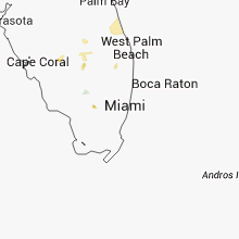
Florida
| Local Time | Report Details |
|---|---|
| 4:00 PM EDT | Trained spotter reported wooden fences blown down...cabbage palms 1.5 feet in diameter snapped...and hardwood trees 2 feet in diameter snapped 2 miles northwest of lion in palm beach county FL, 37.5 miles S of Port Saint Lucie, FL |
| 5:36 PM EDT | Tree on a power line reported at 34 brewster lane in palm coas in flagler county FL, 59.6 miles SSE of Jacksonville, FL |
Colorado
| Local Time | Report Details |
|---|---|
| 2:43 PM MDT | Quarter sized hail reported near Loveland, CO, 47.1 miles N of Denver, CO |
| 3:00 PM MDT | Quarter sized hail reported near Denver, CO, 4.4 miles SE of Denver, CO |
| 3:27 PM MDT | Ping Pong Ball sized hail reported near Englewood, CO, 7.6 miles S of Denver, CO |
| 3:29 PM MDT | Quarter sized hail reported near Littleton, CO, 10.5 miles S of Denver, CO |
| 3:30 PM MDT | Quarter sized hail reported near Englewood, CO, 10.6 miles SSE of Denver, CO |
| 3:30 PM MDT | Hen Egg sized hail reported near Englewood, CO, 7.7 miles S of Denver, CO, 2 1/8 inch hail |
| 3:32 PM MDT | Golf Ball sized hail reported near Englewood, CO, 6.9 miles S of Denver, CO |
| 3:34 PM MDT | Ping Pong Ball sized hail reported near Englewood, CO, 7.6 miles S of Denver, CO |
| 3:35 PM MDT | Quarter sized hail reported near Denver, CO, 5.2 miles ESE of Denver, CO |
| 3:44 PM MDT | Quarter sized hail reported near Denver, CO, 5.6 miles SE of Denver, CO |
| 4:26 PM MDT | Quarter sized hail reported near Strasburg, CO, 35.3 miles E of Denver, CO |
| 4:32 PM MDT | Quarter sized hail reported near Parker, CO, 24.7 miles SE of Denver, CO |
| 5:12 PM MDT | Golf Ball sized hail reported near Limon, CO, 69.6 miles SW of Yuma, CO |
| 5:17 PM MDT | Half Dollar sized hail reported near Limon, CO, 76.2 miles ESE of Denver, CO |
| 5:50 PM MDT | Estimated wind gust between 60 and 70 mph. small limbs dow in kit carson county CO, 55.2 miles SSW of Yuma, CO |
| 5:55 PM MDT | Estimated 60 mph wind gusts and pea to dime size hail covering the groun in kit carson county CO, 44.6 miles SSW of Yuma, CO |
| 6:02 PM MDT | Golf Ball sized hail reported near Limon, CO, 76.3 miles ESE of Denver, CO |
| 6:07 PM MDT | Golf Ball sized hail reported near Limon, CO, 76.5 miles ESE of Denver, CO |
| 6:12 PM MDT | Also reports nickle size hai in yuma county CO, 0.9 miles W of Yuma, CO |
| 6:16 PM MDT | Quarter sized hail reported near Limon, CO, 76.8 miles ESE of Denver, CO |
| 6:20 PM MDT | Storm damage reported in kit carson county CO, 39.2 miles S of Yuma, CO |
| 6:21 PM MDT | Storm damage reported in kit carson county CO, 39.2 miles S of Yuma, CO |
| 6:30 PM MDT | Ping Pong Ball sized hail reported near Bethune, CO, 52.1 miles SSE of Yuma, CO, mix of small and large hail. largest hailstone estimated to be one and a half inches in diameter. |
| 6:35 PM MDT | Storm damage reported in kit carson county CO, 56.8 miles S of Yuma, CO |
| 6:40 PM MDT | Trees and powerlines down. pivots damaged. time estimated by rada in kit carson county CO, 50.1 miles SSE of Yuma, CO |
| 6:43 PM MDT | Storm damage reported in yuma county CO, 36.6 miles SSE of Yuma, CO |
| 6:45 PM MDT | Storm damage reported in kit carson county CO, 64.6 miles SSE of Yuma, CO |
| 6:45 PM MDT | Trees and powerlines down in wray. time estimate in yuma county CO, 26.3 miles E of Yuma, CO |
| 6:50 PM MDT | Storm damage reported in kit carson county CO, 56.8 miles S of Yuma, CO |
| 6:53 PM MDT | Storm damage reported in yuma county CO, 26.3 miles E of Yuma, CO |
| 6:54 PM MDT | Quarter sized hail reported near Wray, CO, 26.4 miles E of Yuma, CO |
Iowa
| Local Time | Report Details |
|---|---|
| 4:10 PM CDT | A number of 4 inch diameter trees and tree branches down in town. likely a combination of the strong synoptic winds enhanced by a thunderstorm outflow just to the south in emmet county IA, 55.9 miles NNE of Storm Lake, IA |
| 10:05 PM CDT | Storm damage reported in cherokee county IA, 29.1 miles WNW of Storm Lake, IA |
Georgia
| Local Time | Report Details |
|---|---|
| 5:24 PM EDT | Quarter sized hail reported near Savannah, GA, 2.9 miles SSE of Savannah, GA, spotter reported quarter size hail near ash street and 52nd street. |
| 5:26 PM EDT | Media reported a tree down on powerlines on skidaway road. time estimated by rada in chatham county GA, 6.3 miles S of Savannah, GA |
| 6:07 PM EDT | Bryan county dispatch reported a tree down at the intersection of highway 144 and strathy hall road. time estimated by rada in bryan county GA, 15.9 miles SW of Savannah, GA |
Wyoming
| Local Time | Report Details |
|---|---|
| 4:57 PM MDT | Quarter sized hail reported near Gillette, WY, 50.9 miles NNE of Casper, WY |
| 7:15 PM MDT | Golf Ball sized hail reported near Lusk, WY, 78 miles SW of Rapid City, SD |
| 7:25 PM MDT | Golf Ball sized hail reported near Lusk, WY, 80 miles SW of Rapid City, SD, wind gusts to 60 mph. blew shingles off the roof and damaged trees. |
Nebraska
| Local Time | Report Details |
|---|---|
| 6:50 PM CDT | Golf Ball sized hail reported near Albion, NE, 55.7 miles NNE of Grand Island, NE |
| 6:57 PM CDT | Golf Ball sized hail reported near Albion, NE, 55.7 miles NNE of Grand Island, NE |
| 7:05 PM CDT | Golf Ball sized hail reported near Grand Island, NE, 1.6 miles WSW of Grand Island, NE, public report of golf ball sized hail around ryder park/ 281 and webb rd |
| 7:07 PM CDT | Quarter sized hail reported near Central City, NE, 30.8 miles NE of Grand Island, NE, report received via web entry. |
| 7:08 PM CDT | Quarter sized hail reported near Grand Island, NE, 1.6 miles WSW of Grand Island, NE |
| 7:09 PM CDT | Ping Pong Ball sized hail reported near Grand Island, NE, 1.6 miles WSW of Grand Island, NE, hail just ended. |
| 7:16 PM CDT | Golf Ball sized hail reported near Grand Island, NE, 3.2 miles W of Grand Island, NE |
| 7:18 PM CDT | Golf Ball sized hail reported near Fullerton, NE, 35.1 miles NE of Grand Island, NE, report received via web entry. |
| 7:29 PM CDT | Baseball sized hail reported near Fullerton, NE, 32.9 miles NE of Grand Island, NE, 1929l and 1934l reports of baseball sized hail along the merrick and nance county line south of fullerton. |
| 7:30 PM CDT | Ping Pong Ball sized hail reported near Laurel, NE, 79.8 miles E of Oneill, NE |
| 7:30 PM CDT | Quarter sized hail reported near Meadow Grove, NE, 55.1 miles SE of Oneill, NE |
| 7:54 PM CDT | Quarter sized hail reported near Genoa, NE, 48.7 miles NE of Grand Island, NE, time est fm radar |
| 8:21 PM CDT | Half Dollar sized hail reported near Stratton, NE, 44.1 miles NNW of Colby, KS, report via social media. |
| 8:22 PM CDT | Baseball sized hail reported near Gibbon, NE, 29.8 miles WSW of Grand Island, NE, public report to dispatch of baseball sized hail south of gibbion. |
| 8:26 PM CDT | Golf Ball sized hail reported near Gibbon, NE, 28.8 miles WSW of Grand Island, NE, golf ball sized hail falling in gibbon |
| 8:30 PM CDT | Tennis Ball sized hail reported near Gibbon, NE, 28.8 miles WSW of Grand Island, NE, tennis ball sized hail falling on the western edge of gibbon. report from dispatch |
| 8:59 PM CDT | Quarter sized hail reported near Kearney, NE, 37.4 miles WSW of Grand Island, NE, quarter sized hail reported 5 e of kearney near the new interchange. |
| 9:00 PM CDT | Quarter sized hail reported near Gibbon, NE, 28.8 miles WSW of Grand Island, NE, nickle to quarter sized hail and 1 inch of rainfall also reported. |
| 9:08 PM CDT | Golf Ball sized hail reported near Ravenna, NE, 30.9 miles WNW of Grand Island, NE, 1 n of ravenna golf ball sized hail and a 45 mph gust front reported from trained spotter. his wind shield also broken from hail. |
| 9:10 PM CDT | Half Dollar sized hail reported near Ayr, NE, 33.9 miles S of Grand Island, NE, spotters reported to dispatch half dollar sized hail falling in ayr. |
| 9:14 PM CDT | Storm damage reported in red willow county NE, 56.1 miles NE of Colby, KS |
| 9:20 PM CDT | Storm damage reported in hayes county NE, 53.1 miles S of North Platte, NE |
| 9:21 PM CDT | Quarter sized hail reported near Glenvil, NE, 33.4 miles S of Grand Island, NE |
| 9:22 PM CDT | Baseball sized hail reported near Ayr, NE, 30.2 miles S of Grand Island, NE |
| 9:27 PM CDT | Quarter sized hail reported near Juniata, NE, 28.3 miles SSW of Grand Island, NE, corrected location of report |
| 9:27 PM CDT | Quarter sized hail reported near Juniata, NE, 24.8 miles SSW of Grand Island, NE |
| 9:28 PM CDT | Storm damage reported in red willow county NE, 59.8 miles NNE of Colby, KS |
| 9:30 PM CDT | Storm damage reported in frontier county NE, 54.2 miles S of North Platte, NE |
| 9:30 PM CDT | Hen Egg sized hail reported near Ashton, NE, 32.5 miles NW of Grand Island, NE, delayed report submitted via web-based report form |
| 9:32 PM CDT | Baseball sized hail reported near Hastings, NE, 28 miles S of Grand Island, NE |
| 9:34 PM CDT | Hen Egg sized hail reported near Hastings, NE, 25.2 miles S of Grand Island, NE |
| 9:35 PM CDT | Quarter sized hail reported near Hastings, NE, 23.2 miles S of Grand Island, NE |
| 9:35 PM CDT | Golf Ball sized hail reported near Hastings, NE, 23.2 miles S of Grand Island, NE |
| 9:47 PM CDT | Ping Pong Ball sized hail reported near Trumbull, NE, 17.3 miles SSE of Grand Island, NE |
| 9:47 PM CDT | Golf Ball sized hail reported near Funk, NE, 57.6 miles WSW of Grand Island, NE, with 50 mph winds |
| 9:50 PM CDT | Golf Ball sized hail reported near Trumbull, NE, 17.3 miles SSE of Grand Island, NE |
| 9:50 PM CDT | Public call est 80mph winds with quarter sized hail mixed in. public also reported heavy rai in furnas county NE, 66.8 miles SSE of North Platte, NE |
| 10:09 PM CDT | Baseball sized hail reported near Arapahoe, NE, 72.8 miles SE of North Platte, NE |
| 10:14 PM CDT | 60mph wind measured...quarter size hail...tree down in furnas county NE, 78.5 miles SE of North Platte, NE |
| 10:15 PM CDT | 6 to 8 inch tree limbs down. structural damage to some building in furnas county NE, 82.5 miles NE of Colby, KS |
| 10:25 PM CDT | Golf Ball sized hail reported near Holdrege, NE, 72.8 miles WSW of Grand Island, NE |
| 10:25 PM CDT | Golf Ball sized hail reported near Arapahoe, NE, 72.8 miles SE of North Platte, NE, golf ball sized hail with heavy rain |
| 10:32 PM CDT | 50 to 60 mph wind gust with golf ball sized hail also in harlan county NE, 65.5 miles SW of Grand Island, NE |
| 10:37 PM CDT | Golf Ball sized hail reported near Holdrege, NE, 67.5 miles SW of Grand Island, NE, golf ball size hail |
| 10:38 PM CDT | Golf Ball sized hail reported near Oxford, NE, 72.7 miles WSW of Grand Island, NE |
| 10:50 PM CDT | Hwy 6/34 from cambridge to arapahoe tree branches 6 to 8 inches in diameter have been knocked down over the hwy. power outages have been reported in arapahoe... correct in furnas county NE, 66.8 miles SSE of North Platte, NE |
| 10:50 PM CDT | Est 60 to 70 mph wind gust. tree limbs dow in harlan county NE, 65.5 miles SW of Grand Island, NE |
| 10:55 PM CDT | Holdrege awos reported a 60 mph wind gust in phelps county NE, 61.9 miles WSW of Grand Island, NE |
| 10:55 PM CDT | Fire crew enroute to heartwell reported 60 mph plus winds several tree limbs down vis down to a block in heavy rain in kearney county NE, 40.8 miles SW of Grand Island, NE |
| 10:55 PM CDT | Fire crew enroute to heartwell reported 60 mph plus winds several tree limbs down vis down to a block in heavy rain. correction to approx. location in kearney county NE, 39.8 miles SW of Grand Island, NE |
| 11:00 PM CDT | Storm damage reported in phelps county NE, 64.1 miles WSW of Grand Island, NE |
| 11:10 PM CDT | Delayed report from web-based form. very large tree branches down across town that have taken down some power lines. time adjusted to match radar dat in franklin county NE, 51.1 miles SW of Grand Island, NE |
| 11:24 PM CDT | Ham operator est 60 mph wind gust in webster county NE, 43.9 miles SSW of Grand Island, NE |
| 11:24 PM CDT | Relayed report of estimated 80 mph. power out and shingles in the yard. time estimated from rada in adams county NE, 36 miles SSW of Grand Island, NE |
| 11:30 PM CDT | Numerous trees and powerlines down. delayed report with time estimated from rada in webster county NE, 58.4 miles S of Grand Island, NE |
| 11:33 PM CDT | Ham operator est 70 mph wind gus in webster county NE, 43.9 miles SSW of Grand Island, NE |
| 11:49 PM CDT | Measured gust at airport in adams county NE, 22.9 miles SSW of Grand Island, NE |
| 11:52 PM CDT | Storm damage reported in saline county NE, 76.1 miles ESE of Grand Island, NE |
| 11:53 PM CDT | Storm damage reported in adams county NE, 23.2 miles S of Grand Island, NE |
| 11:55 PM CDT | Delayed report of some windows blown out in superior and transformers down. time estimated from radar. relayed by medi in nuckolls county NE, 64 miles SSE of Grand Island, NE |
| 11:58 PM CDT | Large trees blown across west bound highway 6 in clay county NE, 25.9 miles SSE of Grand Island, NE |
| 12:09 AM CDT | Hwy 6 and 14 north in clay county NE, 29.5 miles SE of Grand Island, NE |
| 12:20 AM CDT | Fire dept est 50 to 60 mph wind gust in york county NE, 29.5 miles ESE of Grand Island, NE |
| 12:30 AM CDT | Tree limbs up to 2 foot diameter. time estimated from radar. corrected event type to thunderstorm damag in thayer county NE, 57.5 miles SE of Grand Island, NE |
| 12:35 AM CDT | Awos reported 60mph wind gust at 1235am in thayer county NE, 66.5 miles SE of Grand Island, NE |
| 12:39 AM CDT | Storm damage reported in saline county NE, 63 miles ESE of Grand Island, NE |
| 12:40 AM CDT | Storm damage reported in saline county NE, 66.6 miles ESE of Grand Island, NE |
| 12:44 AM CDT | Large tree limbs and branches down. report received via web-based storm report pag in york county NE, 40.8 miles ESE of Grand Island, NE |
| 12:45 AM CDT | 4 to 8 inch limbs blown down. a couple of streets block. entrance to crystal springs south of town blocke in jefferson county NE, 74.1 miles NNW of Manhattan, KS |
| 12:45 AM CDT | 60 to 70 mph winds reported in york in york county NE, 38.9 miles E of Grand Island, NE |
| 1:01 AM CDT | Storm damage reported in saline county NE, 75.9 miles SW of Omaha, NE |
| 1:14 AM CDT | A few streets blocked by fallen limbs. size unknow in saline county NE, 68.8 miles SW of Omaha, NE |
| 1:16 AM CDT | Received thruogh twitte in seward county NE, 67.2 miles WSW of Omaha, NE |
| 1:17 AM CDT | Storm damage reported in lancaster county NE, 51.8 miles WSW of Omaha, NE |
| 1:19 AM CDT | Storm damage reported in gage county NE, 63.7 miles SW of Omaha, NE |
| 1:20 AM CDT | Received through twitte in gage county NE, 75.9 miles N of Manhattan, KS |
| 1:35 AM CDT | Trees blown dow in saunders county NE, 39.5 miles WSW of Omaha, NE |
Minnesota
| Local Time | Report Details |
|---|---|
| 7:37 PM CDT | Delayed report. 3 to 4 trees... powerline down. time estimate in winona county MN, 26.1 miles NW of La Crosse, WI |
Texas
| Local Time | Report Details |
|---|---|
| 7:50 PM CDT | Quarter sized hail reported near Lamesa, TX, 62.9 miles S of Lubbock, TX, quarter size hail reported by spotter |
Oklahoma
| Local Time | Report Details |
|---|---|
| 12:57 AM CDT | Ping Pong Ball sized hail reported near Forgan, OK, 71.4 miles WNW of Woodward, OK, time estimated |
Missouri
| Local Time | Report Details |
|---|---|
| 4:15 AM CDT | Storm damage reported in jackson county MO, 12.7 miles SSE of Kansas City, MO |
| 4:23 AM CDT | Lees summit airport measured wind in jackson county MO, 17.2 miles SE of Kansas City, MO |
Connect with Interactive Hail Maps