

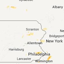
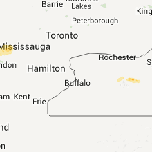
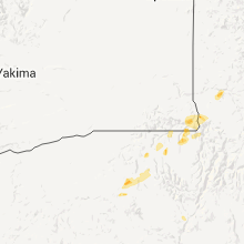
Hail Map for Wednesday, June 22, 2011

Number of Impacted Households on 6/22/2011
0
Impacted by 1" or Larger Hail
0
Impacted by 1.75" or Larger Hail
0
Impacted by 2.5" or Larger Hail
Square Miles of Populated Area Impacted on 6/22/2011
0
Impacted by 1" or Larger Hail
0
Impacted by 1.75" or Larger Hail
0
Impacted by 2.5" or Larger Hail


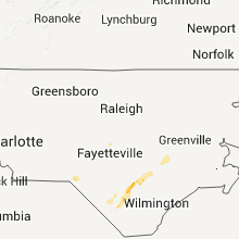


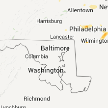


Cities Most Affected by Hail Storms of 6/22/2011
| Hail Size | Demographics of Zip Codes Affected | ||||||
|---|---|---|---|---|---|---|---|
| City | Count | Average | Largest | Pop Density | House Value | Income | Age |
| Manchester Township, NJ | 1 | 1.75 | 1.75 | 532 | $58k | $23.9k | 69.1 |
| Anatone, WA | 1 | 1.75 | 1.75 | 0 | $91k | $24.3k | 54.5 |
| Harrells, NC | 1 | 1.75 | 1.75 | 26 | $69k | $26.6k | 43.2 |
Hail and Wind Damage Spotted on 6/22/2011
Filter by Report Type:Hail ReportsWind Reports
States Impacted
Mississippi, Michigan, Texas, Alabama, Pennsylvania, New Jersey, Florida, Georgia, North Carolina, Ohio, South Carolina, Tennessee, Kentucky, New York, Idaho, Oregon, WashingtonMississippi
| Local Time | Report Details |
|---|---|
| 5:25 PM UTC | Several trees and powerlines down near sandersville. power outages in the city of sandersvill in jones county MS, 75.6 miles ESE of Jackson, MS |
| 5:45 PM UTC | Large tree down across hwy in calhoun county MS, 38.5 miles NW of Starkville, MS |
| 5:45 PM UTC | Large tree on hwy 32 in ellerd community northwest of bruc in calhoun county MS, 51.1 miles NW of Starkville, MS |
| 5:50 PM UTC | *** 1 inj *** roof off of house in vardaman. tree on house..one injur in calhoun county MS, 35.5 miles NW of Starkville, MS |
| 5:50 PM UTC | Roof off of house in vardaman. tree on house..one injur in calhoun county MS, 35.5 miles NW of Starkville, MS |
| 5:50 PM UTC | Several trees and power lines dow in calhoun county MS, 35.5 miles NW of Starkville, MS |
| 6:13 PM UTC | Storm damage reported in chickasaw county MS, 33.6 miles NNW of Starkville, MS |
| 6:36 PM UTC | Tractor trailer blown ove in lee county MS, 52.2 miles N of Starkville, MS |
| 6:36 PM UTC | Tractor trailer blown over on highway 4 in lee county MS, 52.2 miles N of Starkville, MS |
| 6:45 PM UTC | 6 power poles were snapped on elizabeth street in tupel in lee county MS, 54.9 miles N of Starkville, MS |
| 6:54 PM UTC | 3 reports of trees down in mantachi in itawamba county MS, 57.1 miles SW of Florence, AL |
Michigan
| Local Time | Report Details |
|---|---|
| 5:30 PM UTC | Healthy six inch and ten inch diameter trees blew down on billwood hwy near n canal rd. report is from wln in eaton county MI, 54.8 miles WSW of Flint, MI |
| 5:30 PM UTC | Quarter sized hail reported near Ovid, MI, 35.2 miles W of Flint, MI, one inch hail reported in ovid. some small tree limbs down also. |
| 6:00 PM UTC | Debris and tree limbs down at hwy 127 and 22 in lenawee county MI, 75.1 miles SSW of Flint, MI |
| 6:15 PM UTC | 2 trees downed in antrim county MI, 23.5 miles NE of Traverse City, MI |
| 6:25 PM UTC | Numerous 6 to 8 inch trees down and penny to nickel sized hail in saginaw county MI, 30.2 miles NNW of Flint, MI |
| 6:30 PM UTC | Two 15 inch trees down near washington road in saginaw county MI, 29.4 miles NNW of Flint, MI |
| 6:38 PM UTC | Large tree down in shiawassee county MI, 18.3 miles SW of Flint, MI |
| 6:38 PM UTC | Barn roof blown off in ogemaw county MI, 68.4 miles SW of Alpena, MI |
| 6:45 PM UTC | Viewer provided photo to wnem of a large tree uprooted at munger and knight r in bay county MI, 35.6 miles N of Flint, MI |
| 6:56 PM UTC | Many trees down across roads and houses at seymour road between hill and reid road in genesee county MI, 10 miles SW of Flint, MI |
| 7:20 PM UTC | Recorded at nws statio in oakland county MI, 26.6 miles SSE of Flint, MI |
| 7:34 PM UTC | 3 to 4 inch diameter branches down in huron county MI, 51.1 miles NNE of Flint, MI |
| 7:43 PM UTC | Many small tree branches down and heavy rai in tuscola county MI, 36.1 miles NNE of Flint, MI |
| 7:43 PM UTC | Many small tree branches down and heavy rain. wind speed estimated to 60 mp in tuscola county MI, 36.1 miles NNE of Flint, MI |
| 7:43 PM UTC | Barn roof torn off in lapeer county MI, 20.6 miles E of Flint, MI |
| 8:00 PM UTC | Ping Pong Ball sized hail reported near Washington, MI, 38.5 miles ESE of Flint, MI, funnel cloud also reported |
| 8:20 PM UTC | Half Dollar sized hail reported near Armada, MI, 42.6 miles ESE of Flint, MI |
| 8:37 PM UTC | Quarter sized hail reported near Riley, MI, 48.1 miles E of Flint, MI, reported by memphis fire department |
| 8:44 PM UTC | Storm damage reported in genesee county MI, 10.1 miles WSW of Flint, MI |
| 8:45 PM UTC | Measured at mott community college in genesee county MI, 0.7 miles NNW of Flint, MI |
| 8:46 PM UTC | Storm damage reported in saginaw county MI, 19.5 miles NW of Flint, MI |
| 8:46 PM UTC | 18 inch diameter tree fell on car in oakland county MI, 45.1 miles SE of Flint, MI |
| 8:58 PM UTC | 12 to 18 inch tree limb down on maple road in saginaw county MI, 22.2 miles N of Flint, MI |
| 9:00 PM UTC | Large tree limbs down in bay county MI, 40.6 miles NNW of Flint, MI |
| 9:10 PM UTC | Storm damage reported in macomb county MI, 48.6 miles SE of Flint, MI |
| 9:17 PM UTC | One tree down in macomb county MI, 45.6 miles ESE of Flint, MI |
| 9:20 PM UTC | Central dispatch reported a large tree was uprooted and fell on a hous in washtenaw county MI, 53.3 miles S of Flint, MI |
| 9:24 PM UTC | Trees and power lines down across north east st. clair county near lakeport in st. clair county MI, 60.5 miles E of Flint, MI |
| 9:25 PM UTC | A nws storm survey team determined the damage produced in fort gratiot on wednesday june 22nd at approximately 525 pm edt was a result of straight line winds estimated in st. clair county MI, 63.6 miles E of Flint, MI |
| 9:40 PM UTC | High winds with small trees down in lapeer county MI, 30.3 miles E of Flint, MI |
| 10:17 PM UTC | One tree down in macomb county MI, 45.6 miles ESE of Flint, MI |
| 10:30 PM UTC | One tree down in macomb county MI, 53.1 miles SE of Flint, MI |
Texas
| Local Time | Report Details |
|---|---|
| 6:29 PM UTC | Asos platform at valley international airport in harlingen measured 66 mph wind gust. confirmed by airport tower personne in cameron county TX, 24 miles NNW of Brownsville, TX |
Alabama
| Local Time | Report Details |
|---|---|
| 6:38 PM UTC | Multiple trees down around the jacksonville area. two vehicles were damaged by fallen tree in calhoun county AL, 63.8 miles ENE of Birmingham, AL |
| 7:30 PM UTC | Large tree limbs blocking several street in franklin county AL, 36.3 miles SW of Florence, AL |
| 7:30 PM UTC | Multiple trees down in franklin county AL, 36.3 miles SW of Florence, AL |
| 8:15 PM UTC | Tree down on hwy 157 south of moulto in lawrence county AL, 31.6 miles SE of Florence, AL |
| 8:18 PM UTC | Mesonet weather station in lawrence county AL, 39 miles SE of Florence, AL |
| 8:27 PM UTC | Power lines down on county roads 217 and 301 in lawrence county AL, 31 miles ESE of Florence, AL |
| 8:57 PM UTC | A few trees down on highway 13 in chilton county AL, 49.2 miles S of Birmingham, AL |
| 9:04 PM UTC | A one and a half inch diameter tree was blown dow in madison county AL, 61.9 miles E of Florence, AL |
| 9:04 PM UTC | A tree one and a half feet in diameter was blown dow in madison county AL, 61.9 miles E of Florence, AL |
| 9:30 PM UTC | Many numerous trees and power lines down in shelby county AL, 28.4 miles S of Birmingham, AL |
| 9:30 PM UTC | Numerous trees and power lines down near cr 22 and 15 between moores crossroads and dogwoo in shelby county AL, 25.6 miles S of Birmingham, AL |
| 9:51 PM UTC | A bradford pear tree was blown dow in madison county AL, 63.7 miles ESE of Florence, AL |
| 9:55 PM UTC | Power lines and trees down in and around the city of syla in talladega county AL, 39.6 miles SE of Birmingham, AL |
| 10:23 PM UTC | Numerous trees down in and around the city of pell cit in st. clair county AL, 31.4 miles E of Birmingham, AL |
| 11:00 PM UTC | Trees and power lines dow in calhoun county AL, 58.6 miles E of Birmingham, AL |
| 11:12 PM UTC | Trees and power lines dow in calhoun county AL, 71.8 miles W of Atlanta, GA |
Pennsylvania
| Local Time | Report Details |
|---|---|
| 7:12 PM UTC | Wires down in lansdale in montgomery county PA, 74.8 miles WSW of Brooklyn, NY |
| 7:29 PM UTC | Trees down in horsham in montgomery county PA, 69.7 miles WSW of Brooklyn, NY |
| 7:30 PM UTC | Three areas in warrington with trees down in bucks county PA, 67.4 miles WSW of Brooklyn, NY |
New Jersey
| Local Time | Report Details |
|---|---|
| 7:42 PM UTC | Numerous trees and structural damage reported in whiting section of manchester twp in ocean county NJ, 55.2 miles SSW of Brooklyn, NY |
| 3:42 PM EDT | Golf Ball sized hail reported near Manchester, NJ, 55.2 miles SSW of Brooklyn, NY, golf ball hail reported in whiting section of manchester twp |
| 7:50 PM UTC | About 10 trees down in crestwood village. two trees down on houses. large limbs dow in ocean county NJ, 55.2 miles SSW of Brooklyn, NY |
| 3:50 PM EDT | Quarter sized hail reported near Manchester, NJ, 55.2 miles SSW of Brooklyn, NY, quarter size hail reported in whiting |
| 8:01 PM UTC | Trees down on houses... with one person reported trapped in ocean county NJ, 55.2 miles SSW of Brooklyn, NY |
| 8:05 PM UTC | Trees limbs down in burlington county NJ, 60.8 miles SW of Brooklyn, NY |
| 8:05 PM UTC | *** 1 fatal *** downed tree on a car along ridgeway road with a confirmed fatality in ocean county NJ, 49 miles SSW of Brooklyn, NY |
| 8:14 PM UTC | *** 1 fatal *** downed tree on a car along ridgewood road with a confirmed fatality in ocean county NJ, 55.2 miles SSW of Brooklyn, NY |
| 8:14 PM UTC | Downed tree on a car along ridgewood road with a confirmed fatality in ocean county NJ, 55.2 miles SSW of Brooklyn, NY |
| 8:14 PM UTC | Downed tree on a car... with one person reported trapped in ocean county NJ, 55.2 miles SSW of Brooklyn, NY |
| 8:24 PM UTC | Numerous trees down in gloucester county in gloucester county NJ, 84.7 miles ENE of Baltimore, MD |
| 8:50 PM UTC | Numerous trees down across northern part of warren county... including in blairstown... hackettstown... and independence twp in warren county NJ, 47.1 miles SE of Scranton, PA |
| 9:10 PM UTC | Numerous trees down across northern part of warren county... including in blairstown... hackettstown... and independence twp in warren county NJ, 47.1 miles SE of Scranton, PA |
| 9:15 PM UTC | Trees and wires down in warren county NJ, 48.4 miles WNW of Brooklyn, NY |
| 9:20 PM UTC | Five power poles down in east windsor twp in mercer county NJ, 41.4 miles SW of Brooklyn, NY |
| 9:25 PM UTC | Couple of trees down at six flags in ocean county NJ, 44.6 miles SSW of Brooklyn, NY |
Florida
| Local Time | Report Details |
|---|---|
| 7:42 PM UTC | 911 call center reported a tree down along east highway 318 east of u.s. highway 30 in marion county FL, 60.5 miles SSW of Jacksonville, FL |
| 9:20 PM UTC | 911 call center reported a tree down along 85th avenue road. time is estimated based on radar imager in marion county FL, 73.1 miles SSW of Jacksonville, FL |
Georgia
| Local Time | Report Details |
|---|---|
| 7:45 PM UTC | Shingles off douglas county high school. additional damage 3 trees down on north burnt hickory and a tree downed at the intersection of post and poole roa in douglas county GA, 20.7 miles W of Atlanta, GA |
| 7:58 PM UTC | Public reports 2 trees down near power ferry road and windy hil in cobb county GA, 10.1 miles NNW of Atlanta, GA |
| 8:12 PM UTC | Clayton county 911 relayed a report of a tree down in near conle in clayton county GA, 8.3 miles SSE of Atlanta, GA |
| 8:12 PM UTC | Cherokee ema relayed a report of power lines down 3 n of canto in cherokee county GA, 37.1 miles N of Atlanta, GA |
| 8:15 PM UTC | Storm damage reported in dekalb county GA, 4.7 miles E of Atlanta, GA |
| 8:15 PM UTC | Fulton county emergency management reports several power lines down around the count in fulton county GA, 5.5 miles SSE of Atlanta, GA |
| 8:20 PM UTC | Dekalb county 911 relayed reports of 2 downed trees and more than 6 power lines dow in dekalb county GA, 8.1 miles E of Atlanta, GA |
| 8:26 PM UTC | Whitfield county ema relayed a report of a tree down and powerlines down north of dalto in whitfield county GA, 27 miles SE of Chattanooga, TN |
| 8:30 PM UTC | Cherokee county emergency management relayed a 911 report of a large tree downed on a hous in cherokee county GA, 26.8 miles NNW of Atlanta, GA |
| 8:35 PM UTC | Gwinnett county 911 relayed reports of at least 6 trees and 5 power lines downed in the western part of the count in gwinnett county GA, 16.1 miles NE of Atlanta, GA |
| 8:35 PM UTC | Cherokee county emegency management relayed a report of trees down blocking the roa in cherokee county GA, 29.1 miles N of Atlanta, GA |
| 9:07 PM UTC | Barrow county 911 relayed a report of several trees dow in barrow county GA, 40.3 miles ENE of Atlanta, GA |
| 9:12 PM UTC | Cherokee county emegency management relayed a report of power lines dow in cherokee county GA, 37.1 miles N of Atlanta, GA |
| 9:20 PM UTC | Oconee county 911 relayed reports of several downed trees in the area of moores ford and ridgeway road in oconee county GA, 47.9 miles E of Atlanta, GA |
| 9:20 PM UTC | Oconee county 911 relayed reports of 2 trees and a powerline dow in oconee county GA, 46.7 miles ENE of Atlanta, GA |
| 9:22 PM UTC | Walton county ema relayed a report of a few trees and powerlines down across the count in walton county GA, 39.5 miles ENE of Atlanta, GA |
| 9:23 PM UTC | Public reports a large red oak tree was downed by wind in hall county GA, 41.2 miles NE of Atlanta, GA |
| 9:40 PM UTC | Oconee county 911 relayed reports of several downed lines near the malcolm bridge and lenru roads are in oconee county GA, 56.5 miles ENE of Atlanta, GA |
| 9:45 PM UTC | Athens-clarke county 911 reports 2 downed tree in clarke county GA, 59.9 miles ENE of Atlanta, GA |
| 9:53 PM UTC | Madison county 911 relayed reports of a downed tree and powerline in colber in madison county GA, 64.7 miles SSW of Greenville, SC |
| 9:53 PM UTC | Jackson county 911 relayed a report of 2 trees downed onto powerlines on the northern end of the count in jackson county GA, 60.4 miles ENE of Atlanta, GA |
| 10:00 PM UTC | Tree on powerline near swift rd in stephens county GA, 45.5 miles WSW of Greenville, SC |
| 10:05 PM UTC | Three large trees down on power lines at andrews road and skyline drive. several trees also reported down around the count in stephens county GA, 44.5 miles WSW of Greenville, SC |
| 10:05 PM UTC | Trees uprooted along andrews rd in stephens county GA, 44.5 miles WSW of Greenville, SC |
| 10:05 PM UTC | Tree on a car near brookhaven circle in stephens county GA, 39.4 miles WSW of Greenville, SC |
| 10:12 PM UTC | Trees down countywid in franklin county GA, 47.9 miles SW of Greenville, SC |
| 10:25 PM UTC | Trees down all around count in hart county GA, 38.1 miles SSW of Greenville, SC |
| 10:40 PM UTC | Trees down countywide in elbert county GA, 51.9 miles SSW of Greenville, SC |
| 11:17 PM UTC | Heard county 911 relayed a report of a downed tree on antioch roa in heard county GA, 53.5 miles WSW of Atlanta, GA |
North Carolina
| Local Time | Report Details |
|---|---|
| 9:02 PM UTC | Tree down on old wire road in scotland county NC, 79.7 miles ESE of Charlotte, NC |
| 9:04 PM UTC | Tree down on church street in laurel hil in scotland county NC, 78.9 miles ESE of Charlotte, NC |
| 9:13 PM UTC | Tree down at st johns church road and rockingham road in laurel hil in scotland county NC, 78.4 miles ESE of Charlotte, NC |
| 9:40 PM UTC | Multiple trees down across the laurinburg are in scotland county NC, 83.6 miles ESE of Charlotte, NC |
| 10:08 PM UTC | Tree down on house located on coley rd. time of event estimated by rada in bladen county NC, 42 miles WNW of Wilmington, NC |
| 10:08 PM UTC | Multiple large limbs and powerlines down near lisbon rd. time of event estimated by rada in bladen county NC, 37.7 miles WNW of Wilmington, NC |
| 10:08 PM UTC | Quarter sized hail reported near Council, NC, 37.7 miles WNW of Wilmington, NC, quarter size hail reported near lisbon rd. time of event estimated by radar. |
| 10:12 PM UTC | Skirting ripped off a mobile home on airport road. tree limbs down. pea size hai in bladen county NC, 41.5 miles NW of Wilmington, NC |
| 10:15 PM UTC | Quarter sized hail reported near Elizabethtown, NC, 45.7 miles NW of Wilmington, NC, hail to the size of quarters was reported on highway 53 east. the hail lasted for about 15 minutes. |
| 10:34 PM UTC | Golf Ball sized hail reported near Harrells, NC, 42.3 miles NW of Wilmington, NC, golfball size hail reported on highway 210 between highway 41 and us highway 701 |
| 10:35 PM UTC | County dispatch reported tree down on coopers creek r in swain county NC, 44.8 miles SE of Knoxville, TN |
| 10:38 PM UTC | Tree down near harrells hwy and lamb roa in sampson county NC, 43.8 miles NNW of Wilmington, NC |
| 10:38 PM UTC | Tree down on cc roa in sampson county NC, 42.6 miles NNW of Wilmington, NC |
| 10:43 PM UTC | Several trees down on lundy roa in sampson county NC, 41.5 miles NNW of Wilmington, NC |
| 10:45 PM UTC | Cherokee dispatch reported tree down on old soco rd. time estimated from rada in swain county NC, 47.8 miles SE of Knoxville, TN |
| 10:45 PM UTC | Trees down on state highway 2 in bladen county NC, 65.5 miles NW of Wilmington, NC |
| 10:45 PM UTC | Tree down at rogers mill road and magnolia road in delwa in sampson county NC, 42 miles NNW of Wilmington, NC |
| 11:10 PM UTC | Tree down on blind bridge road. time estimated from radar in duplin county NC, 46.3 miles N of Wilmington, NC |
| 11:20 PM UTC | Roof blown off business at the intersection of d w williams rd and nc hwy 11. time estimated by rada in duplin county NC, 49.3 miles N of Wilmington, NC |
| 11:29 PM UTC | Trees and powerlines down. relayed from 911 cente in duplin county NC, 50 miles N of Wilmington, NC |
| 11:30 PM UTC | Large limbs down on sr 157 in columbus county NC, 56.2 miles WNW of Wilmington, NC |
| 11:42 PM UTC | Tree limbs down on bill albertson roa in duplin county NC, 60.1 miles N of Wilmington, NC |
| 11:45 PM UTC | Tree down blocking highway 191 in mills rive in henderson county NC, 38.6 miles N of Greenville, SC |
| 11:53 PM UTC | Power lines down along rugby roa in henderson county NC, 41.7 miles N of Greenville, SC |
| 11:53 PM UTC | Power lines down on naples roa in henderson county NC, 41.7 miles N of Greenville, SC |
| 12:02 AM UTC | Tree limb down across powerlines on liddell road in lenoir county NC, 63.3 miles NNE of Wilmington, NC |
| 12:04 AM UTC | Tree down on house near hwy 258. relayed from 911 center in lenoir county NC, 68.8 miles ESE of Raleigh, NC |
| 12:07 AM UTC | Roof blown off sandy bottom church in lenoir county NC, 72.4 miles NNE of Wilmington, NC |
| 12:12 AM UTC | Powerlines down on hwy 58. relayed from 911 cente in lenoir county NC, 68.5 miles ESE of Raleigh, NC |
| 12:16 AM UTC | Trees down on british road. time estimated from radar in lenoir county NC, 68.4 miles ESE of Raleigh, NC |
| 12:22 AM UTC | Several trees blown dow in rutherford county NC, 54.3 miles NE of Greenville, SC |
| 12:25 AM UTC | Tree down on caroline roa in rutherford county NC, 54.3 miles NE of Greenville, SC |
| 12:27 AM UTC | Tree down on main stree in rutherford county NC, 52.7 miles W of Charlotte, NC |
| 12:35 AM UTC | Trees down on williamsburg cour in cleveland county NC, 29 miles W of Charlotte, NC |
| 12:35 AM UTC | Trees down along brown mountain beach roa in burke county NC, 52.7 miles SSE of Bristol, TN |
| 12:49 AM UTC | Storm damage reported in burke county NC, 57.3 miles NW of Charlotte, NC |
| 12:54 AM UTC | Tree in roadway near harmon rd and highway 182 in lincoln county NC, 31.8 miles WNW of Charlotte, NC |
| 1:00 AM UTC | Trees down at nc 18 and bethel roa in burke county NC, 60.3 miles NW of Charlotte, NC |
| 1:05 AM UTC | Trees down along delmar roa in lincoln county NC, 28.9 miles NW of Charlotte, NC |
| 1:15 AM UTC | Several trees and power lines dow in catawba county NC, 37.6 miles NW of Charlotte, NC |
| 1:15 AM UTC | Outbuilding blown into roadway on dellinger driv in catawba county NC, 34.1 miles NW of Charlotte, NC |
| 1:17 AM UTC | Power lines down on sixth street and third avenu in catawba county NC, 45.2 miles NW of Charlotte, NC |
| 1:26 AM UTC | Tree on power lin in iredell county NC, 41.5 miles N of Charlotte, NC |
| 1:28 AM UTC | Tree in roadway on snow creek roa in iredell county NC, 39.2 miles N of Charlotte, NC |
| 1:28 AM UTC | Tree on power lin in iredell county NC, 39.2 miles N of Charlotte, NC |
| 1:30 AM UTC | A few reports of trees...power lines and large limbs down across the cit in mecklenburg county NC, 1.6 miles SSE of Charlotte, NC |
| 1:30 AM UTC | Power lines down at old island ford road and b and b roa in catawba county NC, 37.9 miles NNW of Charlotte, NC |
Ohio
| Local Time | Report Details |
|---|---|
| 9:08 PM UTC | Healthy foot to foot and a half diameter tree branch broken off in van wert county OH, 32.8 miles SE of Fort Wayne, IN |
| 9:08 PM UTC | Healthy foot to foot and a half diameter tree down in van wert county OH, 32.8 miles SE of Fort Wayne, IN |
| 11:50 PM UTC | One tree downed near e franklin street in centerville. time estimated from rada in montgomery county OH, 40.8 miles NNE of Cincinnati, OH |
South Carolina
| Local Time | Report Details |
|---|---|
| 10:18 PM UTC | Tree on power lin in oconee county SC, 31.4 miles WSW of Greenville, SC |
| 10:22 PM UTC | Large branches broke in anderson county SC, 21.6 miles S of Greenville, SC |
| 10:27 PM UTC | One tree dow in oconee county SC, 27.6 miles W of Greenville, SC |
| 10:33 PM UTC | Trees down along coffee roa in oconee county SC, 29.1 miles WSW of Greenville, SC |
| 10:46 PM UTC | Numerous trees down around city of anderso in anderson county SC, 21.6 miles S of Greenville, SC |
| 10:48 PM UTC | Multiple trees down along highway 12 in pickens county SC, 12.8 miles SW of Greenville, SC |
| 11:07 PM UTC | Multiple trees down along highways 186 and 13 in pickens county SC, 6.9 miles N of Greenville, SC |
| 11:15 PM UTC | Trees and power lines down greenville downtown at randall and earle street in greenville county SC, 13.1 miles E of Greenville, SC |
| 11:15 PM UTC | Numerous trees down in mariett in greenville county SC, 15.1 miles NNE of Greenville, SC |
| 11:20 PM UTC | Large tree down park avenue downtown greenvill in greenville county SC, 13.1 miles E of Greenville, SC |
| 11:23 PM UTC | Estimated 60 mph wind gus in greenville county SC, 23 miles E of Greenville, SC |
| 11:23 PM UTC | Large tree limbs down on hwy 10 in laurens county SC, 31.7 miles SE of Greenville, SC |
| 11:24 PM UTC | Tree blown down on ginger lan in greenville county SC, 17.6 miles ENE of Greenville, SC |
| 11:25 PM UTC | A few trees dow in greenville county SC, 22.3 miles ENE of Greenville, SC |
| 11:25 PM UTC | Large branches broke in greenville county SC, 17.6 miles ENE of Greenville, SC |
| 11:26 PM UTC | Kgsp asos in spartanburg county SC, 22.1 miles ENE of Greenville, SC |
| 11:28 PM UTC | Storm damage reported in greenville county SC, 22.3 miles ENE of Greenville, SC |
| 11:30 PM UTC | Tree down at gsp airport entrance roa in greenville county SC, 22.3 miles ENE of Greenville, SC |
| 11:30 PM UTC | Large branches broke in spartanburg county SC, 28.5 miles ENE of Greenville, SC |
| 11:30 PM UTC | Trees and power lines down along lynn roa in greenville county SC, 17.6 miles ENE of Greenville, SC |
| 11:40 PM UTC | 60 mph estimated wind gust at highways 14 and 414 in landru in spartanburg county SC, 33 miles NE of Greenville, SC |
| 11:42 PM UTC | Trees down along crescent circl in spartanburg county SC, 38.8 miles ENE of Greenville, SC |
| 11:45 PM UTC | Large branches broke in spartanburg county SC, 38.1 miles ENE of Greenville, SC |
| 11:45 PM UTC | Trees down hampton and little mountain r in spartanburg county SC, 32.7 miles ENE of Greenville, SC |
| 11:47 PM UTC | Trees and power lines down along highway 221 near main s in spartanburg county SC, 32.7 miles ENE of Greenville, SC |
| 12:20 AM UTC | Trees snapped in hal in cherokee county SC, 46.4 miles WSW of Charlotte, NC |
Tennessee
| Local Time | Report Details |
|---|---|
| 11:45 PM UTC | Two trees down on black fox rd in grainger county TN, 32 miles NNE of Knoxville, TN |
| 12:15 AM UTC | Couple trees down on lee valley rd in hawkins county TN, 50.9 miles ENE of Knoxville, TN |
Kentucky
| Local Time | Report Details |
|---|---|
| 12:04 AM UTC | Several reports from multiple sources of damage near churchill downs in jefferson county KY, 16.1 miles N of Louisville, KY |
| 12:07 AM UTC | Power lines down...arching occurring...possibly additional damage near churchill downs in jefferson county KY, 16.1 miles N of Louisville, KY |
| 12:10 AM UTC | Equipment rental business at central and floyd roads have reported damage including walls caved in and roof torn off... high voltage lines down as well in jefferson county KY, 16.1 miles N of Louisville, KY |
| 1:32 AM UTC | Report of siding off houses...small trees and fences down...other large objects displaced near breckenridge ln and meadow ridge dr in jefferson county KY, 16.1 miles N of Louisville, KY |
| 1:41 AM UTC | Large trees down...estimating 12 inch diameter limbs down...tree on fire on sue ellen drive in jefferson county KY, 17.3 miles NNE of Louisville, KY |
| 2:01 AM UTC | Storm damage reported in meade county KY, 23.1 miles W of Louisville, KY |
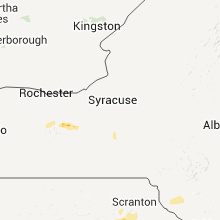
New York
| Local Time | Report Details |
|---|---|
| 12:40 AM UTC | Half Dollar sized hail reported near Gorham, NY, 52.1 miles WSW of Syracuse, NY |
| 7:52 AM UTC | Tree on house on boller ave in livingston county NY, 60.5 miles E of Buffalo, NY |
| 10:25 AM UTC | Large tree down on wires... partially blocking route 366 in tompkins county NY, 38.7 miles SSW of Syracuse, NY |
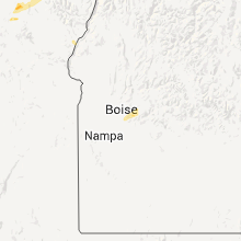
Idaho
| Local Time | Report Details |
|---|---|
| 12:43 AM UTC | Quarter sized hail reported near Culdesac, ID, 38.1 miles NNW of Grangeville, ID, spotter ne25 several 1 inch hails |
| 12:55 AM UTC | Time estimated by radar. video via kpvi shows damage to garage and camper in the groveland area on the west side of blackfoo in bingham county ID, 26 miles SW of Idaho Falls, ID |
Oregon
| Local Time | Report Details |
|---|---|
| 1:40 AM UTC | Quarter sized hail reported near Elgin, OR, 38.3 miles SSE of Walla Walla, WA, 1 inch hail reported. |
| 2:25 AM UTC | Quarter sized hail reported near Enterprise, OR, 45.3 miles E of Walla Walla, WA, hail from pea size and up to the size of a quarter. in 20 minutes received 0.60 inches rain but did not cause flooding. peak gusts around 30 mph both from the north ahe |
Washington
| Local Time | Report Details |
|---|---|
| 2:30 AM UTC | Golf Ball sized hail reported near Anatone, WA, 45.6 miles WNW of Grangeville, ID, public report of golf ball size hail over montgomery ridge |
| 2:42 AM UTC | Tree limbs 1 1/2 inches down from thunderstorm winds in asotin county WA, 47.5 miles WNW of Grangeville, ID |
Connect with Interactive Hail Maps