

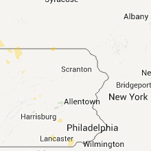
Hail Map for Tuesday, June 21, 2011

Number of Impacted Households on 6/21/2011
0
Impacted by 1" or Larger Hail
0
Impacted by 1.75" or Larger Hail
0
Impacted by 2.5" or Larger Hail
Square Miles of Populated Area Impacted on 6/21/2011
0
Impacted by 1" or Larger Hail
0
Impacted by 1.75" or Larger Hail
0
Impacted by 2.5" or Larger Hail


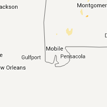


Cities Most Affected by Hail Storms of 6/21/2011
| Hail Size | Demographics of Zip Codes Affected | ||||||
|---|---|---|---|---|---|---|---|
| City | Count | Average | Largest | Pop Density | House Value | Income | Age |
| Fayetteville, NC | 2 | 1.75 | 1.75 | 274 | $47k | $19.6k | 37.8 |
| Sidney, KY | 1 | 3.00 | 3.00 | 46 | $50k | $19.9k | 41.3 |
| Bangs, TX | 1 | 2.00 | 2.00 | 17 | $42k | $29.7k | 43.3 |
| Bangor, MI | 1 | 2.00 | 2.00 | 92 | $70k | $31.6k | 38.2 |
| Muskegon, MI | 1 | 2.00 | 2.00 | 1723 | $90k | $37.5k | 41.2 |
| Marietta, OH | 1 | 1.75 | 1.75 | 238 | $82k | $33.4k | 42.8 |
| Center, TX | 1 | 1.75 | 1.75 | 39 | $58k | $29.5k | 36.2 |
| Blackwell, TX | 1 | 1.75 | 1.75 | 2 | $39k | $29.5k | 50.2 |
| Garden City, TX | 1 | 1.75 | 1.75 | 1 | $52k | $36.3k | 38.3 |
| Kemp, TX | 1 | 1.75 | 1.75 | 83 | $73k | $35.2k | 45.0 |
| Gretna, VA | 1 | 1.75 | 1.75 | 39 | $73k | $29.2k | 47.0 |
| Midkiff, TX | 1 | 1.75 | 1.75 | 0 | $60k | $26.9k | 30.3 |
| Gary, TX | 1 | 1.75 | 1.75 | 27 | $54k | $28.1k | 41.8 |
| Millsap, TX | 1 | 1.75 | 1.75 | 33 | $71k | $39.9k | 43.1 |
| Cisco, TX | 1 | 1.75 | 1.75 | 14 | $29k | $26.2k | 41.5 |
Hail and Wind Damage Spotted on 6/21/2011
Filter by Report Type:Hail ReportsWind Reports
States Impacted
Arkansas, North Carolina, Kentucky, Georgia, South Carolina, Mississippi, Indiana, Missouri, Alabama, Virginia, Texas, Wisconsin, Illinois, Louisiana, Ohio, Michigan, Tennessee, West Virginia, Pennsylvania, New York, Maryland, FloridaArkansas
| Local Time | Report Details |
|---|---|
| 12:55 PM UTC | Tree blown down in town in ashley county AR, 27 miles N of Bastrop, LA |
| 1:00 PM UTC | One tree blown down along highway 133 near the milo community in ashley county AR, 31.8 miles N of Bastrop, LA |
| 1:05 AM UTC | Quarter sized hail reported near Mena, AR, 43.9 miles SSE of Fort Smith, AR, hail was reported by volunteer fire department in lake hinkle. hail was nickel to quarter sized. |
North Carolina
| Local Time | Report Details |
|---|---|
| 1:05 PM UTC | Quarter sized hail reported near Apex, NC, 14.6 miles WSW of Raleigh, NC, nickel to quarter size hail on apex barbecue road |
| 3:37 PM UTC | Trees down on east washington street in rockingham in richmond county NC, 64.6 miles ESE of Charlotte, NC |
| 3:37 PM UTC | Trees down along skyline drive in rockingham in richmond county NC, 64.4 miles ESE of Charlotte, NC |
| 5:56 PM UTC | Half Dollar sized hail reported near Asheville, NC, 46.8 miles N of Greenville, SC, ncdc employee reports dime to half dollar sized hail in the bent creek subdivision. |
| 6:00 PM UTC | Quarter sized hail reported near Asheville, NC, 46.8 miles N of Greenville, SC, quarter size hail. |
| 6:02 PM UTC | Quarter sized hail reported near Asheville, NC, 51 miles N of Greenville, SC, quarter size hail reported at brevard road and i-40. |
| 6:25 PM UTC | Quarter sized hail reported near Marshall, NC, 58.6 miles SSW of Bristol, TN, emergency management reported quarter size hail in the big pine community. |
| 6:26 PM UTC | Quarter sized hail reported near Marshall, NC, 58.6 miles SSW of Bristol, TN, quarter size hail 2 miles northeast of marshall. |
| 6:30 PM UTC | Trees reported down on hwy 276 ne of brevard. time estimated from rada in transylvania county NC, 31.9 miles N of Greenville, SC |
| 6:32 PM UTC | Quarter sized hail reported near Deep Gap, NC, 47.2 miles ESE of Bristol, TN, hail fell on owl rest lane. |
| 7:30 PM UTC | Tree down on bearwallow mtn. tree down in edneyville area on lamb mtn. road. tree down near bat cave. time estimated dy rada in henderson county NC, 45.1 miles NNE of Greenville, SC |
| 7:44 PM UTC | Quarter sized hail reported near Boone, NC, 40.5 miles SE of Bristol, TN |
| 7:50 PM UTC | Quarter sized hail reported near Marion, NC, 51.2 miles SSE of Bristol, TN, spotter from fire dept reported nickel to quarter size hail. |
| 8:00 PM UTC | Quarter sized hail reported near Marion, NC, 53.6 miles SSE of Bristol, TN, spotter from fire dept reported nickel to quarter size hail. time estimated from radar. extreme northeast mcdowell county. |
| 8:08 PM UTC | Numerous trees down including apple trees and the top half of other tree in wilkes county NC, 55.6 miles ESE of Bristol, TN |
| 8:55 PM UTC | Quarter sized hail reported near Creston, NC, 35.3 miles ESE of Bristol, TN |
| 9:00 PM UTC | Quarter sized hail reported near Lenoir, NC, 60.2 miles SE of Bristol, TN, hail quarter to half dollar sized. |
| 9:10 PM UTC | Large limbs down along maplebrook driv in surry county NC, 78.5 miles N of Charlotte, NC |
| 9:11 PM UTC | Large tree down on a fenc in wilkes county NC, 57.3 miles ESE of Bristol, TN |
| 9:30 PM UTC | Tree down on shingle gap roa in wilkes county NC, 59 miles ESE of Bristol, TN |
| 9:30 PM UTC | Two trees down on parsonsville roa in wilkes county NC, 57 miles ESE of Bristol, TN |
| 9:48 PM UTC | Bradford pear blown dow in wilkes county NC, 64.2 miles NNW of Charlotte, NC |
| 9:50 PM UTC | Trees and powerlines down north part of county including mt olive church rd near h in alexander county NC, 58.3 miles NNW of Charlotte, NC |
| 10:00 PM UTC | Bradford pear down on fishing creek arbor roa in wilkes county NC, 64 miles NNW of Charlotte, NC |
| 10:00 PM UTC | Half Dollar sized hail reported near Salemburg, NC, 50.4 miles SSE of Raleigh, NC, public reported up to golf ball size hail north of salemburg |
| 10:02 PM UTC | Tree down on liberty grove roa in wilkes county NC, 67.6 miles NNW of Charlotte, NC |
| 10:20 PM UTC | Quarter sized hail reported near Roseboro, NC, 51.3 miles S of Raleigh, NC, 911 dispatcher drove through quarter size hail north of salemburg |
| 10:24 PM UTC | Quarter sized hail reported near Fayetteville, NC, 47.6 miles SSW of Raleigh, NC, public reports quarter hail east of fort bragg |
| 10:28 PM UTC | Tree down on copeland church roa in surry county NC, 75.3 miles SSW of Roanoke, VA |
| 10:40 PM UTC | Tree down at the intersection of highway 268 and quaker church roa in surry county NC, 73 miles SSW of Roanoke, VA |
| 10:50 PM UTC | Multiple 3-4 inch diameter limbs down on hwy 18 going into shelb in cleveland county NC, 40 miles W of Charlotte, NC |
| 11:20 PM UTC | Trees down on robin roa in rockingham county NC, 54.6 miles S of Roanoke, VA |
| 11:20 PM UTC | Gust to 55 mph at spotters in cleveland county NC, 37.6 miles WNW of Charlotte, NC |
| 7:20 PM EDT | Golf Ball sized hail reported near Fayetteville, NC, 52.1 miles S of Raleigh, NC |
| 11:22 PM UTC | Trees down on puckett road near highway 704 in rockingham county NC, 61.5 miles S of Roanoke, VA |
| 11:26 PM UTC | Tree blown down on a power line. the power line fell on a house causing a structural fir in rockingham county NC, 63.5 miles WNW of Raleigh, NC |
| 11:30 PM UTC | Quarter sized hail reported near Stedman, NC, 51.5 miles S of Raleigh, NC, public reported quarter size hail |
| 11:30 PM UTC | Quarter sized hail reported near Stoneville, NC, 60.2 miles S of Roanoke, VA |
| 11:35 PM UTC | Quarter sized hail reported near Benson, NC, 28.4 miles S of Raleigh, NC, nickel to quarter size hail in benson |
| 11:38 PM UTC | Quarter sized hail reported near Stoneville, NC, 57.5 miles S of Roanoke, VA |
| 11:38 PM UTC | Ping Pong Ball sized hail reported near Stoneville, NC, 58.3 miles S of Roanoke, VA |
| 11:40 PM UTC | Quarter sized hail reported near Fayetteville, NC, 51.4 miles SSW of Raleigh, NC, quarter size hail reported at filter plant road and bragg blvd |
| 11:43 PM UTC | Trees down on settle bridge road near river roa in rockingham county NC, 59.7 miles S of Roanoke, VA |
| 11:45 PM UTC | Quarter sized hail reported near Benson, NC, 28.3 miles S of Raleigh, NC, quarter sized hail was reported along west woodall street near south mclamb street. |
| 11:53 PM UTC | Trees down on price road near shady grove roa in rockingham county NC, 53.7 miles S of Roanoke, VA |
| 11:53 PM UTC | Quarter sized hail reported near Fayetteville, NC, 52.1 miles SSW of Raleigh, NC, public reported quarter size hail on ft. bragg road. |
| 11:55 PM UTC | Quarter sized hail reported near Fayetteville, NC, 52.1 miles SSW of Raleigh, NC, public reports quarter size hail at hay street and ft. bragg road |
| 11:56 PM UTC | Trees down on bethlehem church road near the dan rive in rockingham county NC, 56.3 miles S of Roanoke, VA |
| 11:56 PM UTC | Trees down on cherry grove roa in caswell county NC, 57.9 miles NW of Raleigh, NC |
| 7:58 PM EDT | Golf Ball sized hail reported near Fayetteville, NC, 51.8 miles SSW of Raleigh, NC, golf ball size hail was reported by a motorist along the all american freeway betweeen santa fe drive and raeford road. the hail was covering the ground. |
| 12:00 AM UTC | Hoke co dot reported numerous trees down across roads in the rockfish area... occurred around 8p in hoke county NC, 60.5 miles SSW of Raleigh, NC |
| 12:00 AM UTC | Several trees were reported down across avent ferry road near birdie lan in lee county NC, 31.5 miles SW of Raleigh, NC |
| 12:00 AM UTC | Several large trees down in rockingham county NC, 55.1 miles S of Roanoke, VA |
| 12:00 AM UTC | Quarter sized hail reported near Fayetteville, NC, 52.4 miles SSW of Raleigh, NC, quarter size hail in downtown fayetteville |
| 12:05 AM UTC | Quarter sized hail reported near Four Oaks, NC, 20.8 miles SSE of Raleigh, NC, nickel to quarter size hail near route 210. report from the elevation fire department. |
| 12:35 AM UTC | Quarter sized hail reported near Sanford, NC, 28.5 miles WSW of Raleigh, NC, quarter size hail on lower moncure road |
| 12:40 AM UTC | Lawndale post office employee reported large limbs down on fallston-waco road south of fallston. time estimated from rada in cleveland county NC, 39.4 miles WNW of Charlotte, NC |
| 8:42 PM EDT | Quarter sized hail reported near Aberdeen, NC, 62.5 miles SW of Raleigh, NC, off duty police officer reported quarter size hail in downtown aberdeen |
| 12:47 AM UTC | Trees down on allison roa in caswell county NC, 62.6 miles SSE of Roanoke, VA |
| 1:05 AM UTC | Tree down along rex road in wake county NC, 18.9 miles SW of Raleigh, NC |
| 1:05 AM UTC | Quarter sized hail reported near Apex, NC, 14.6 miles WSW of Raleigh, NC, nickel to quarter size hail on apex barbecue road. corrected time. |
| 1:10 AM UTC | Quarter sized hail reported near Spring Lake, NC, 45.9 miles SSW of Raleigh, NC, public reported quarter size hail in spring lake at 910 pm |
| 1:36 AM UTC | Multiple trees down at 1818 mcgougan road in fayetteville in cumberland county NC, 51.1 miles SSW of Raleigh, NC |
| 1:45 AM UTC | Quarter sized hail reported near West End, NC, 64.4 miles SW of Raleigh, NC, quarter size hail reported in west end. |
| 1:59 AM UTC | Trees down along highway 6 in caswell county NC, 59.5 miles NW of Raleigh, NC |
| 2:12 AM UTC | Tree down on warner road in montgomery county NC, 53.7 miles E of Charlotte, NC |
| 2:19 AM UTC | Tree down on mccallum road in montgomery county NC, 57.1 miles E of Charlotte, NC |
| 2:22 AM UTC | Tree down near rob currie road and 109 s in anson county NC, 44.7 miles ESE of Charlotte, NC |
| 2:29 AM UTC | Tree down on first st in montgomery county NC, 60.4 miles E of Charlotte, NC |
| 2:30 AM UTC | Several reports of wind damage throughout the city...a tree on a home on joyce dr...tree on a car on harris bvd...a large tree down across sharon lane...power lines dow in mecklenburg county NC, 1.6 miles SSE of Charlotte, NC |
| 2:30 AM UTC | Multiple trees dow in cumberland county NC, 51.4 miles SSW of Raleigh, NC |
| 2:45 AM UTC | Media relayed report of a tree on a house on dundeen s in mecklenburg county NC, 0.7 miles WSW of Charlotte, NC |
| 3:05 AM UTC | Tree down on cold springs road in cabarrus county NC, 21.2 miles NE of Charlotte, NC |
| 3:07 AM UTC | Tree down near allen pond road in anson county NC, 49.2 miles ESE of Charlotte, NC |
| 3:12 AM UTC | 911 center reported multiple power lines down in polkton in anson county NC, 39 miles ESE of Charlotte, NC |
| 3:14 AM UTC | Trees down in west and east concor in cabarrus county NC, 19 miles NE of Charlotte, NC |
| 3:22 AM UTC | 911 center reported multiple trees down in the mcfarlan area in anson county NC, 56.3 miles ESE of Charlotte, NC |
| 3:37 AM UTC | 911 center reported trees down along ardsley road in richmond county NC, 64.6 miles ESE of Charlotte, NC |
| 3:37 AM UTC | Trees down on east washington street in rockingham in richmond county NC, 64.6 miles ESE of Charlotte, NC |
| 3:37 AM UTC | Trees down along skyline drive in rockingham in richmond county NC, 64.4 miles ESE of Charlotte, NC |
| 3:37 AM UTC | Trees down on mill road in rockingham in richmond county NC, 63.8 miles ESE of Charlotte, NC |
| 3:37 AM UTC | Power lines down near ellerbe springs inn on highway 220 in richmond county NC, 61.6 miles E of Charlotte, NC |
| 4:21 AM UTC | 3-4 large tree branches down on 300 block of ashwood circl in randolph county NC, 65.8 miles W of Raleigh, NC |
| 4:30 AM UTC | One tree was reported down across cemetery road near west frazier drive in lee county NC, 37.2 miles SW of Raleigh, NC |
| 4:30 AM UTC | One tree was reported down across kendale drive near cemetery roa in lee county NC, 37.6 miles SW of Raleigh, NC |
| 4:38 AM UTC | 911 center reported tree down across the road at nursery road and highway 27 in harnett county NC, 35.3 miles SSW of Raleigh, NC |
| 5:05 AM UTC | Powerlines down 800 block of gregory s in guilford county NC, 66.9 miles WNW of Raleigh, NC |
| 5:05 AM UTC | Powerlines down 500 block of homeland avenu in guilford county NC, 66.4 miles WNW of Raleigh, NC |
Kentucky
| Local Time | Report Details |
|---|---|
| 1:10 PM UTC | Storm damage reported in christian county KY, 50.5 miles NW of Nashville, TN |
| 7:30 PM UTC | Report of tree down on power lines on deatsville road off cedar grove road in bullitt county KY, 4.9 miles SE of Louisville, KY |
| 8:03 PM UTC | Tree on power lines...12th and caldwell stree in mccracken county KY, 52.4 miles ESE of Cape Girardeau, MO |
| 8:31 PM UTC | Trees down on river road near highway 60. road is blocke in livingston county KY, 65.7 miles E of Cape Girardeau, MO |
| 8:50 PM UTC | Quarter sized hail reported near Canada, KY, 63.5 miles SW of Charleston, WV, mostly dime sized with lots of nickel sized and a few quarters. |
| 8:50 PM UTC | Tea Cup sized hail reported near Sidney, KY, 63.6 miles SW of Charleston, WV, big creek fire chief reported to emergency manager doug tackett that several windshields in vehicles had been broken due to the hail. |
| 9:19 PM UTC | Quarter sized hail reported near , , 35.8 miles SE of Cincinnati, OH, via wlwt |
| 9:33 PM UTC | County dispatch reports trees and power lines down all over county. specifically at 127 south and spring creek bridge and in the cedar hill communit in clinton county KY, 82 miles NW of Knoxville, TN |
| 9:34 PM UTC | Metal roof sheets bent up. large tree branch down. partial privacy fence section missin in boyd county KY, 52.3 miles W of Charleston, WV |
| 10:00 PM UTC | Dispatch reports trees down on wornall lane in harrison county KY, 47.1 miles NNW of Irvine, KY |
| 11:17 PM UTC | Trees across road at dogwood fork roa in johnson county KY, 66.1 miles E of Irvine, KY |
| 11:17 PM UTC | Tree across road at bethe in mccreary county KY, 58.1 miles NNW of Knoxville, TN |
| 11:19 PM UTC | Trees blown down with an estimated wind gust between 40 and 45 mp in mccreary county KY, 51.8 miles NNW of Knoxville, TN |
| 11:20 PM UTC | Damage to a church steeple at hwy 92 and sr 1044 near pine knott. also several trees down within a quarter mile of the church. one tree landed on a house. another was s in mccreary county KY, 56.6 miles NNW of Knoxville, TN |
| 11:22 PM UTC | 50 knot gust reported at the london aso in laurel county KY, 39.7 miles S of Irvine, KY |
| 11:25 PM UTC | One tree down on house in woodbine in whitley county KY, 55.5 miles S of Irvine, KY |
| 11:28 PM UTC | 50 knot gust reported at the london aso in laurel county KY, 39.7 miles S of Irvine, KY |
| 11:30 PM UTC | 3 trees down along highway 20 in whitley county KY, 61.3 miles NNW of Knoxville, TN |
| 11:30 PM UTC | One tree down in the hemlock subdivision in williamsbur in whitley county KY, 55.5 miles NNW of Knoxville, TN |
| 11:30 PM UTC | 4 to 5 inch diameter limbs broke in mccreary county KY, 52.8 miles NNW of Knoxville, TN |
| 11:44 PM UTC | Tree down on robinson creek roa in clay county KY, 30.8 miles S of Irvine, KY |
| 11:46 PM UTC | Sign blown off of save a lot buildin in jackson county KY, 18.7 miles S of Irvine, KY |
| 11:59 PM UTC | Tree fell on a power line along hood ave. time estimated from rada in estill county KY, 0.3 miles E of Irvine, KY |
| 11:59 PM UTC | Power out in town due to a tree falling on the power lines near 4th street. time estimated from rada in estill county KY, 1.5 miles ESE of Irvine, KY |
| 12:01 AM UTC | Few trees down in pebwort in owsley county KY, 19.2 miles SE of Irvine, KY |
| 12:06 AM UTC | Trees down in white as in lee county KY, 16.1 miles SE of Irvine, KY |
| 12:09 AM UTC | Trees down on south fork roa in lee county KY, 16.7 miles ESE of Irvine, KY |
| 12:09 AM UTC | Trees down on south fork roa in montgomery county KY, 18.8 miles NNE of Irvine, KY |
| 12:09 AM UTC | Trees down in white as in lee county KY, 16.1 miles SE of Irvine, KY |
| 12:09 AM UTC | Tree down on mills creek roa in knox county KY, 51.1 miles SSE of Irvine, KY |
| 12:12 AM UTC | Trees down in st. helen in lee county KY, 19.6 miles ESE of Irvine, KY |
| 12:12 AM UTC | Trees down in talleg in lee county KY, 23.2 miles ESE of Irvine, KY |
| 12:26 AM UTC | Trees down in zacharia in lee county KY, 16.1 miles E of Irvine, KY |
| 12:30 AM UTC | Tree across roa in wolfe county KY, 27.4 miles E of Irvine, KY |
| 12:30 AM UTC | One tree down on highway 3 in breathitt county KY, 36.1 miles ESE of Irvine, KY |
| 12:36 AM UTC | Tree across roa in wolfe county KY, 33.2 miles E of Irvine, KY |
| 12:36 AM UTC | Tree across road near laurel hil in wolfe county KY, 27.4 miles E of Irvine, KY |
| 12:38 AM UTC | Trees down in maytow in morgan county KY, 29.5 miles ENE of Irvine, KY |
| 12:42 AM UTC | Trees down in eze in morgan county KY, 32.1 miles ENE of Irvine, KY |
| 12:47 AM UTC | Trees down in woodsben in morgan county KY, 37.9 miles ENE of Irvine, KY |
| 12:51 AM UTC | One tree down in west libert in morgan county KY, 41.2 miles ENE of Irvine, KY |
| 12:55 AM UTC | A tree down on highway 460 wes in magoffin county KY, 49.1 miles E of Irvine, KY |
| 1:04 AM UTC | Tree across roa in bath county KY, 38.4 miles N of Irvine, KY |
| 1:05 AM UTC | 3 inch or larger limb broken out of a five foot tre in harlan county KY, 54 miles WNW of Bristol, TN |
| 1:08 AM UTC | Trees across road at nichols branch and riddle fork roads in the dry creek communit in rowan county KY, 42.6 miles NE of Irvine, KY |
| 1:14 AM UTC | Trees down on highway 70 in elliott county KY, 56.6 miles ENE of Irvine, KY |
| 1:14 AM UTC | Trees down on highway 64 in elliott county KY, 57 miles ENE of Irvine, KY |
| 1:18 AM UTC | Tree across road at stika in johnson county KY, 64.6 miles E of Irvine, KY |
| 1:21 AM UTC | Trees down on highway 7 and route 504 near gree in elliott county KY, 57.5 miles ENE of Irvine, KY |
| 1:21 AM UTC | Trees down on highway 64 in elliott county KY, 57 miles ENE of Irvine, KY |
| 1:23 AM UTC | Tree across roa in johnson county KY, 65.9 miles E of Irvine, KY |
| 1:23 AM UTC | Tree across dogwood fork roa in johnson county KY, 66.8 miles E of Irvine, KY |
| 1:25 AM UTC | Trees down on highway 7 and horton flat roa in elliott county KY, 62.1 miles ENE of Irvine, KY |
| 2:34 AM UTC | Report of a tree down on peytons cree in pike county KY, 58.6 miles NNW of Bristol, TN |
| 2:34 AM UTC | A tree reported down on route 8 in pike county KY, 50.7 miles N of Bristol, TN |
| 2:47 AM UTC | Report of a tree down on peytons cree in pike county KY, 54.7 miles N of Bristol, TN |
Georgia
| Local Time | Report Details |
|---|---|
| 3:30 PM UTC | Ham radio reported large oak tree uprooted off of farrington drive near ft. gordo in richmond county GA, 14 miles SW of Augusta, GA |
| 6:05 PM UTC | Quarter sized hail reported near Rabun Gap, GA, 46.6 miles W of Greenville, SC, report of hail up to the size of quarters between mountain city and rabun gap. |
| 6:13 PM UTC | Quarter sized hail reported near Rabun Gap, GA, 46.6 miles W of Greenville, SC, report of hail up to the size of quarters between mountain city and rabun gap. |
| 10:17 PM UTC | Chattooga county ema relayed a report of at least six trees down in the the count in chattooga county GA, 39.1 miles S of Chattanooga, TN |
| 10:34 PM UTC | Catoosa county ema relayed a report at least 5 trees on powerlines along with numerous trees down in the fort oglethorpe are in catoosa county GA, 7.2 miles SSE of Chattanooga, TN |
| 10:34 PM UTC | Walker county 911 relayed a report of numerous trees down in the lookout mountain are in walker county GA, 5.4 miles SSW of Chattanooga, TN |
| 11:05 PM UTC | Wilkinson ema relayed a report of ten trees down in the irwinton are in wilkinson county GA, 83.2 miles WSW of Augusta, GA |
| 11:07 PM UTC | Roofs removed from one house and three barns. numerous trees snappe in hart county GA, 41.2 miles SSW of Greenville, SC |
| 11:19 PM UTC | Trees down along metasville rd west of lincolnto in lincoln county GA, 37.9 miles NW of Augusta, GA |
| 11:58 PM UTC | Quarter sized hail reported near Hephzibah, GA, 15.8 miles SSW of Augusta, GA, quarter sized hail in hephzibah |
| 12:34 AM UTC | Spotternetwork report of 60 mph winds south of augusta in richmond county GA, 8.9 miles S of Augusta, GA |
| 3:10 AM UTC | Fire department reports powerlines down and power outages in the keysville are in burke county GA, 22.1 miles SW of Augusta, GA |
| 3:22 AM UTC | Sheriff dispatch reported trees and powerlines dow in richmond county GA, 15.2 miles SSW of Augusta, GA |
| 3:43 AM UTC | Sheriff dispatch reported trees and powerlines dow in richmond county GA, 1.9 miles SW of Augusta, GA |
South Carolina
| Local Time | Report Details |
|---|---|
| 3:50 PM UTC | Ham radio reported tree blocking the roadway near clearwate in aiken county SC, 4.3 miles ENE of Augusta, GA |
| 3:54 PM UTC | Ham radio reports trees down in bat in aiken county SC, 6.5 miles ENE of Augusta, GA |
| 11:00 PM UTC | Multiple trees down throughout the calhoun falls area. hwy 81 south and lee street. time estimated from rada in abbeville county SC, 51.1 miles S of Greenville, SC |
| 11:15 PM UTC | Large limbs down on duncan-reidville road and gano drive. time determined by rada in spartanburg county SC, 27.9 miles E of Greenville, SC |
| 11:28 PM UTC | Multiple trees down between starr and iv in anderson county SC, 31.6 miles S of Greenville, SC |
| 11:45 PM UTC | Trees in spartanburg county SC, 30.3 miles E of Greenville, SC |
| 12:00 AM UTC | Quarter sized hail reported near Laurens, SC, 39.7 miles SE of Greenville, SC |
| 12:06 AM UTC | Trees down...along wilson town roa in laurens county SC, 31.7 miles SE of Greenville, SC |
| 12:06 AM UTC | Large branches broke in greenwood county SC, 48.5 miles SSE of Greenville, SC |
| 12:07 AM UTC | Trees down on cherokee falls r in cherokee county SC, 40.7 miles WSW of Charlotte, NC |
| 12:17 AM UTC | Trees down on holly ridge r in cherokee county SC, 38.9 miles W of Charlotte, NC |
| 12:23 AM UTC | Trees down across the city. trees reported down on a house. time determined by rada in laurens county SC, 31.8 miles ESE of Greenville, SC |
| 12:23 AM UTC | Multiple trees down around town and 2nw on hwy 52 and trinity church roa in laurens county SC, 39.7 miles SE of Greenville, SC |
| 12:30 AM UTC | Large limbs down near friendship church roa in laurens county SC, 31.8 miles ESE of Greenville, SC |
| 12:44 AM UTC | Large branches of 6 to 8 inch diameter broke off tree and fell onto hous in spartanburg county SC, 36.5 miles E of Greenville, SC |
| 12:45 AM UTC | *** 1 inj *** trees down scuffletown campground. tree destroyed rv camper and injuried person insid in greenville county SC, 22.4 miles E of Greenville, SC |
| 12:50 AM UTC | Highway patrol reported a couple of trees blown down along highway 56 in the pauline are in spartanburg county SC, 41.5 miles E of Greenville, SC |
| 1:00 AM UTC | Several trees down across the tow in spartanburg county SC, 47.3 miles ENE of Greenville, SC |
| 1:00 AM UTC | Trees down at the intersection of island ford rd and bellfast r in newberry county SC, 56 miles NNE of Augusta, GA |
| 1:09 AM UTC | Tree down near the intersection of church street and wofford street. time determined by rada in spartanburg county SC, 38.8 miles ENE of Greenville, SC |
| 1:20 AM UTC | Trees down at intersection of beechcrrek rd and county lake d in lexington county SC, 54.8 miles NE of Augusta, GA |
| 1:28 AM UTC | Numerous trees down on interstate 26 between mile markers 80 and 8 in newberry county SC, 60.2 miles NNE of Augusta, GA |
| 1:43 AM UTC | Trees down on interstate 77 near mile marker 48 in fairfield county SC, 52.7 miles S of Charlotte, NC |
| 1:44 AM UTC | Trees down at the intersection of us 321 and broom mill r in fairfield county SC, 68.3 miles S of Charlotte, NC |
| 1:50 AM UTC | Dispatch center reports numerous trees down in the southwest corner of the count in fairfield county SC, 67.9 miles NE of Augusta, GA |
| 1:55 AM UTC | Highway patrol reports a tree down at cherry rd and anderson rd. also a tree down on unity st in fort mill...and pleasant rd- 4 nnw fort mil in york county SC, 19.4 miles SSW of Charlotte, NC |
| 2:00 AM UTC | Highway patrol reports a tree down on gold hill rd and another tree down on old nation rd 3 nne fort mil in york county SC, 13.5 miles SSW of Charlotte, NC |
| 2:00 AM UTC | South carolina highway patrol reported trees down screaming eagle road and koon roa in richland county SC, 67.8 miles NE of Augusta, GA |
| 2:04 AM UTC | One tree down on hwy 16 in york county SC, 15.8 miles SSW of Charlotte, NC |
| 2:12 AM UTC | Trees down across west end of county reported by sherriffs dispatch in lancaster county SC, 41.5 miles S of Charlotte, NC |
| 2:20 AM UTC | Numerous trees down across southeastern fairfield count in fairfield county SC, 63 miles S of Charlotte, NC |
| 2:21 AM UTC | Sheriff dispatch reported trees down in neeses and norwa in orangeburg county SC, 49 miles E of Augusta, GA |
| 2:22 AM UTC | Several limbs down near swansea. also 1/2 inch hai in calhoun county SC, 58.8 miles ENE of Augusta, GA |
| 2:25 AM UTC | Quarter sized hail reported near Fort Mill, SC, 15.8 miles SSW of Charlotte, NC, wind gusts estimated around 45 mph. |
| 2:27 AM UTC | South carolina highway patrol reported trees down on neese highway and juniper stree in orangeburg county SC, 49.5 miles E of Augusta, GA |
| 2:33 AM UTC | Several trees down on sr 151 south of pagelan in chesterfield county SC, 41.8 miles SE of Charlotte, NC |
| 2:45 AM UTC | Truck driver on i-26 at mm 137 reported estimated 65 mph winds and nickel sized hail in calhoun county SC, 59.4 miles WNW of Charleston, SC |
| 3:01 AM UTC | Trees and powerlines down across the lugoff and camden are in kershaw county SC, 67.6 miles S of Charlotte, NC |
| 3:06 AM UTC | Sheriff dispatch reported trees down in the hopkins are in richland county SC, 68.3 miles NW of Charleston, SC |
| 3:15 AM UTC | Sheriff dispatch reported several trees down in the eastover are in richland county SC, 61.6 miles NW of Charleston, SC |
| 3:22 AM UTC | South carolina highway patrol reported trees down at us highway 15 and dubose siding roa in sumter county SC, 60.8 miles NNW of Charleston, SC |
| 3:40 AM UTC | Tree reportedly down on community road. time estimated based on radar data in marlboro county SC, 68.4 miles ESE of Charlotte, NC |
| 3:50 AM UTC | Sheriff dispatch reported trees and powerlines down in bishopville in lee county SC, 71.9 miles N of Charleston, SC |
| 3:54 AM UTC | A tree was reportedly down on academy road. the time was estimated based on radar data in marlboro county SC, 77.8 miles ESE of Charlotte, NC |
| 4:03 AM UTC | A tree was reportedly down on oscar fletcher road. the time was estimated based on radar dat in marlboro county SC, 81.1 miles ESE of Charlotte, NC |
| 4:07 AM UTC | A tree was reportedly down on pea bridge road. the time was estimated based on radar dat in marlboro county SC, 83.2 miles ESE of Charlotte, NC |
| 5:25 AM UTC | Large limbs dow in sumter county SC, 63 miles NNW of Charleston, SC |
| 5:55 AM UTC | Large limbs and a few trees down in the area of mcnight and adkins rd in sumter county SC, 55.9 miles NNW of Charleston, SC |
| 5:59 AM UTC | Large limbs down across the roadwa in lee county SC, 57 miles N of Charleston, SC |
Mississippi
| Local Time | Report Details |
|---|---|
| 5:05 PM UTC | Tree down blocking county road 402 in neshoba county MS, 59.1 miles SSW of Starkville, MS |
| 5:10 PM UTC | Tree down on county round 430 in neshoba county MS, 53.7 miles SSW of Starkville, MS |
| 5:55 PM UTC | A few trees were blown down along with a power lin in warren county MS, 40.4 miles W of Jackson, MS |
| 6:23 PM UTC | Tree down on county round 430 in neshoba county MS, 53.7 miles SSW of Starkville, MS |
| 6:23 PM UTC | Tree down blocking county road 402 in neshoba county MS, 59.1 miles SSW of Starkville, MS |
| 6:25 PM UTC | Tree down across mount olive road in oktibbeha county MS, 5.9 miles S of Starkville, MS |
| 6:30 PM UTC | Power lines down in oktibbeha county MS, 0.6 miles SW of Starkville, MS |
| 6:40 PM UTC | Power lines were downed near columbus lake along wilkins-wise r in lowndes county MS, 20.7 miles E of Starkville, MS |
| 6:43 PM UTC | 6 trees were blown down and 3 power poles were snapped. damage occurred from columbus to roughly 5 n of columbu in lowndes county MS, 24 miles E of Starkville, MS |
| 7:15 PM UTC | Trees down near saltill in lee county MS, 63.4 miles N of Starkville, MS |
| 8:40 PM UTC | A few trees down off liberty rd in adams county MS, 84 miles SW of Jackson, MS |
| 9:28 PM UTC | A few trees down in lauderdale county MS, 70.7 miles S of Starkville, MS |
| 9:40 PM UTC | A few trees down in lauderdale county MS, 68.2 miles S of Starkville, MS |
| 10:25 PM UTC | Large tree down blocking hwy 3 in marion county MS, 76 miles SSE of Jackson, MS |
| 10:25 PM UTC | Large tree down blocking hwy 35. this tree also landed on a car...no injurie in marion county MS, 76 miles SSE of Jackson, MS |
| 10:29 PM UTC | Tree down across lampton hilltop rd in marion county MS, 78 miles SSE of Jackson, MS |
| 10:47 PM UTC | Several trees down just s of hwy 98 in w-central part of county near marion co lin in lamar county MS, 76.8 miles SSE of Jackson, MS |
| 10:59 PM UTC | A couple trees down across road in lamar county MS, 88.1 miles WNW of Mobile, AL |
| 11:04 PM UTC | A tree fell on a house along lakeview cir...causing major damage to the roof. also a tree fell on a mobile home along j barnes road...splitting it in hal in lamar county MS, 85.8 miles WNW of Mobile, AL |
| 11:06 PM UTC | Tree down on i-59...tree landed on a vehicl in lamar county MS, 83.5 miles SE of Jackson, MS |
| 11:06 PM UTC | Trees down on i-59 near mile marker 64...no vehicles were involve in lamar county MS, 83.5 miles SE of Jackson, MS |
| 11:12 PM UTC | A few trees down in the dixie communit in forrest county MS, 85.1 miles WNW of Mobile, AL |
Indiana
| Local Time | Report Details |
|---|---|
| 5:30 PM UTC | Tree snapped at base. fell on power line in jackson county IN, 56.4 miles N of Louisville, KY |
| 8:30 PM UTC | Large tree blocking state road 31 near 900 south. time approximate in bartholomew county IN, 46.1 miles SSE of Indianapolis, IN |
| 10:25 PM UTC | Trees and power lines down throughout the nw part of the county including the city of elkhart. time estimated from rada in elkhart county IN, 61.9 miles NW of Fort Wayne, IN |
| 11:20 PM UTC | A few branches downe in tippecanoe county IN, 45 miles NW of Indianapolis, IN |
| 11:30 PM UTC | *** 1 in tippecanoe county IN, 62.5 miles NW of Indianapolis, IN |
| 11:45 PM UTC | Power poles snapped at yeager and northwestern road in tippecanoe county IN, 61.5 miles NW of Indianapolis, IN |
| 11:46 PM UTC | Billboard sign blown down...tree down in whitley county IN, 17.2 miles WNW of Fort Wayne, IN |
| 11:51 PM UTC | Trees down at cr 10 and sr 427...time estimated from radar in de kalb county IN, 29.8 miles NNE of Fort Wayne, IN |
| 11:59 PM UTC | Trees down across road near sr 427 and cr 10 in steuben county IN, 32.9 miles NNE of Fort Wayne, IN |
| 11:59 PM UTC | Tree limb brought a power line down in whitley county IN, 21.5 miles NW of Fort Wayne, IN |
| 12:12 AM UTC | Large branches down and power outage in kosciusko county IN, 40.8 miles WNW of Fort Wayne, IN |
| 12:25 AM UTC | House trailer heavily damaged in steuben county IN, 35.1 miles N of Fort Wayne, IN |
| 1:02 AM UTC | Scattered trees down in laporte county IN, 50.8 miles ESE of Chicago, IL |
| 1:29 AM UTC | Persistant 40 to 50 mph winds with gusts to 60 mp in lake county IN, 29.6 miles SSE of Chicago, IL |
Missouri
| Local Time | Report Details |
|---|---|
| 6:00 PM UTC | Quarter sized hail reported near Caulfield, MO, 77.4 miles SSW of Salem, MO |
| 7:17 PM UTC | Quarter sized hail reported near Potosi, MO, 43.5 miles ENE of Salem, MO |
| 7:34 PM UTC | Estimated 50 to 60 mph wind in jefferson county MO, 37.1 miles SSW of Saint Louis, MO |
| 7:50 PM UTC | Quarter sized hail reported near Festus, MO, 30.4 miles SSW of Saint Louis, MO, hail ranged from dime to quarter size. |
Alabama
| Local Time | Report Details |
|---|---|
| 6:10 PM UTC | Tree down near the intersection of cr 23 and al hwy 28 near coatopa. another tree down 2 miles west of us hwy 80 near coatopa drive. winds estimated around 50 mp in sumter county AL, 57.1 miles NW of Camden, AL |
| 7:10 PM UTC | Three trees reported down along boyd rd near echola. another tree down along bone camp rd just off of al hwy 17 in tuscaloosa county AL, 57.6 miles WSW of Birmingham, AL |
| 8:06 PM UTC | Several trees were blown down across the county. some areas impacted include rasch road...huntsville road...patsy drive...goose shoals bridge...ramblewood drive...cr 68 in lauderdale county AL, 0.7 miles NNW of Florence, AL |
| 8:10 PM UTC | Two outbuildings destroyed and one large pecan tree over 100 years old blown over. one tin building destroye in colbert county AL, 7.7 miles E of Florence, AL |
| 8:13 PM UTC | Tree on house on rock ridge road in mountainbrook. trees down on robert smith drive in homewoo in jefferson county AL, 9.5 miles ENE of Birmingham, AL |
| 8:14 PM UTC | Fiffty to sixty mph winds were reported and blew off some awning at a schoo in marshall county AL, 53 miles NNE of Birmingham, AL |
| 8:17 PM UTC | Tree limbs snapped and awnings ripped out of their setting. several trees down around the country club in irondal in jefferson county AL, 7.6 miles NE of Birmingham, AL |
| 8:17 PM UTC | Tree limbs snapped and awnings ripped out of their setting. winds estimated at 40 mp in jefferson county AL, 7.6 miles NE of Birmingham, AL |
| 8:18 PM UTC | Power lines down on fourth avenue in arab in marshall county AL, 58 miles NNE of Birmingham, AL |
| 8:18 PM UTC | Trees and powerlines down near intersection of 7th street and cullman roa in marshall county AL, 58 miles NNE of Birmingham, AL |
| 8:18 PM UTC | Tree in road on hall circle in marshall county AL, 63.4 miles NNE of Birmingham, AL |
| 8:20 PM UTC | Trees blown down on highway 6 in marshall county AL, 58.8 miles NNE of Birmingham, AL |
| 8:20 PM UTC | Trees down on thomas road in h in blount county AL, 22.7 miles N of Birmingham, AL |
| 8:20 PM UTC | Trees blown down on 4th stree in marshall county AL, 67.6 miles SW of Chattanooga, TN |
| 8:28 PM UTC | Refurbished tin and truss roofing over an old flat roof peeled off the top of a business on main street. sections of roofing also partially removed from athletic center in jefferson county AL, 13.5 miles ENE of Birmingham, AL |
| 8:30 PM UTC | Parts of the big lots roof blown over the road for block in colbert county AL, 4.2 miles S of Florence, AL |
| 8:33 PM UTC | A few trees with weakened root systems uprooted along and north of old springville road. winds estimated at 70 mph. sporadic wind damage continues to the jefferson coun in jefferson county AL, 19.2 miles NE of Birmingham, AL |
| 8:35 PM UTC | 66 mph wind gust measured at meridanville awo in madison county AL, 63.5 miles E of Florence, AL |
| 8:35 PM UTC | Damage to house. several trees were blown dow in marshall county AL, 61.6 miles NE of Birmingham, AL |
| 8:37 PM UTC | Tree down blocking highway 11 and hwy 17 in st. clair county AL, 27.9 miles NE of Birmingham, AL |
| 8:37 PM UTC | Tree down blocking highw in st. clair county AL, 27.9 miles NE of Birmingham, AL |
| 8:40 PM UTC | A wind gust to 62 mph was measured by spotter home weatehr equipmen in madison county AL, 62.9 miles E of Florence, AL |
| 8:40 PM UTC | A large tree was blown down near the post office in owens crossroads. large tree limbs blown down in the area as wel in madison county AL, 71 miles E of Florence, AL |
| 8:40 PM UTC | Large hardwood tree with shallow root system uprooted. winds estimated at 70 mp in st. clair county AL, 23.5 miles NE of Birmingham, AL |
| 8:50 PM UTC | A tree was blown down on hickory avenu in cullman county AL, 44.8 miles N of Birmingham, AL |
| 8:53 PM UTC | Mobile home was blown off a trailer transpor in madison county AL, 65.3 miles WSW of Chattanooga, TN |
| 8:54 PM UTC | A tree was blown down on low gap roa in madison county AL, 70.8 miles ESE of Florence, AL |
| 8:54 PM UTC | Tree down on old wagon in st. clair county AL, 29.3 miles E of Birmingham, AL |
| 8:54 PM UTC | Trees and powerlines down in the holly springs community and trees down in the highland lakes communit in blount county AL, 28.6 miles NE of Birmingham, AL |
| 8:56 PM UTC | Tree was blown down at 791 gurley pik in madison county AL, 66.9 miles WSW of Chattanooga, TN |
| 9:03 PM UTC | Tree blown down on home and power lines down on summitt roa in cullman county AL, 51.5 miles NNE of Birmingham, AL |
| 9:04 PM UTC | Tree on house on mount oak driv in marshall county AL, 58 miles NNE of Birmingham, AL |
| 9:05 PM UTC | Tree down on hwy 75 north on the blount and marshall county lin in blount county AL, 48.5 miles NNE of Birmingham, AL |
| 9:07 PM UTC | Limbs and treetops reported snapped from trees. some structural damag in marshall county AL, 53.5 miles NNE of Birmingham, AL |
| 9:08 PM UTC | Numerous trees down. 4265 warrior vall in etowah county AL, 44.7 miles NE of Birmingham, AL |
| 9:10 PM UTC | A tree was blown down on power lines on cr 17 in the letcher communit in jackson county AL, 48.8 miles WSW of Chattanooga, TN |
| 9:10 PM UTC | Tree down on maple hill roa in marshall county AL, 60.6 miles NNE of Birmingham, AL |
| 9:11 PM UTC | Trees down at danville high schoo in morgan county AL, 43.3 miles SE of Florence, AL |
| 9:11 PM UTC | Trees were blown down in decatu in morgan county AL, 41.7 miles ESE of Florence, AL |
| 9:12 PM UTC | Numerous trees down. us278/do in etowah county AL, 47.8 miles NE of Birmingham, AL |
| 9:13 PM UTC | Tree on hounse on rock ridge road in mountainbrook. trees down on robert smith drive in homewoo in jefferson county AL, 9.5 miles ENE of Birmingham, AL |
| 9:16 PM UTC | Tree on house on matt morrow road in marshall county AL, 59.4 miles NNE of Birmingham, AL |
| 9:18 PM UTC | Trees were blown down in madison on portal lane and shelton roa in madison county AL, 54.8 miles E of Florence, AL |
| 9:20 PM UTC | Trees down. 2612 lawson gap r in etowah county AL, 58.5 miles NE of Birmingham, AL |
| 9:20 PM UTC | Tree down on oakleaf lan in marshall county AL, 58.6 miles NNE of Birmingham, AL |
| 9:22 PM UTC | A 60 mph gust was reported at the intersection of slaughter road and old madison pik in madison county AL, 55.3 miles E of Florence, AL |
| 9:23 PM UTC | Tree blocked mohawk cliff road near ohatche in calhoun county AL, 49 miles ENE of Birmingham, AL |
| 9:25 PM UTC | A tree was blown down on research drive off of wynn drive across street near baron rada in madison county AL, 58 miles E of Florence, AL |
| 9:25 PM UTC | Power lines blown down on charity lan in madison county AL, 63.4 miles E of Florence, AL |
| 9:26 PM UTC | Numerous trees down. church st/cox g in etowah county AL, 59.9 miles NE of Birmingham, AL |
| 9:28 PM UTC | Trees blown down at sherwood park and robin hood lane east of research park. trees also reported down on us hwy 72 east near gurley pik in madison county AL, 65.3 miles WSW of Chattanooga, TN |
| 9:29 PM UTC | Tree fell on power lines on cedar creek roa in marshall county AL, 58 miles NNE of Birmingham, AL |
| 9:30 PM UTC | Tree down on power lines on midfield roa in marshall county AL, 57.1 miles NNE of Birmingham, AL |
| 9:35 PM UTC | Trees were blown down on research par in madison county AL, 57.3 miles E of Florence, AL |
| 9:36 PM UTC | Trees down blocking road on friar tuck wa in dekalb county AL, 53.1 miles SW of Chattanooga, TN |
| 9:40 PM UTC | Trees down on littleton rd attala and thrasher rd altoona in etowah county AL, 44.7 miles NE of Birmingham, AL |
| 9:41 PM UTC | Trees were reported down everywhere at madison manor on sulliva in madison county AL, 53.3 miles E of Florence, AL |
| 9:41 PM UTC | Trees were reported down everywhere near madison manor on sulliva in madison county AL, 53.3 miles E of Florence, AL |
| 9:42 PM UTC | Trees blown down on cr 5 in dekalb county AL, 55.2 miles SSW of Chattanooga, TN |
| 9:45 PM UTC | A tree was blown down and is blocking the roa in dekalb county AL, 66.8 miles NE of Birmingham, AL |
| 9:45 PM UTC | Two large oak trees snapped in half...one tree was 4 feet in diamete in madison county AL, 53.8 miles E of Florence, AL |
| 9:54 PM UTC | Trees blown down on cr 51 and cr 5 in dekalb county AL, 38.8 miles SW of Chattanooga, TN |
| 9:55 PM UTC | 62 mph wind gust measured at fort payne automated weather station /awos in dekalb county AL, 46.1 miles SSW of Chattanooga, TN |
| 10:09 PM UTC | Trees were blown down on cr 108...cr 515...and alabama hwy 7 in dekalb county AL, 38.3 miles SW of Chattanooga, TN |
| 10:12 PM UTC | Trees down at intersection of county road 738 and county road 14 in dekalb county AL, 28.1 miles SSW of Chattanooga, TN |
| 10:51 PM UTC | Tree was blocking county road 85 near vincen in shelby county AL, 24.9 miles ESE of Birmingham, AL |
| 12:14 AM UTC | Several trees down on highway 3 in lowndes county AL, 42.5 miles E of Camden, AL |
| 1:38 AM UTC | Trees reported down along several roads on the southeast side of the cit in montgomery county AL, 48.5 miles WSW of Auburn, AL |
| 1:40 AM UTC | Monroe co. ema reports 5 trees down in the frisco city/excel areas with 2 of the trees causing accidents. power lines down on hwy 136 between excel and hwy 8 in monroe county AL, 39.3 miles S of Camden, AL |
| 2:00 AM UTC | Ema director reports numerous trees down and power outages across the count in conecuh county AL, 43.7 miles SSE of Camden, AL |
Virginia
| Local Time | Report Details |
|---|---|
| 6:38 PM UTC | Numerous large tree limbs down along with dime sized hail in giles county VA, 47 miles W of Roanoke, VA |
| 7:52 PM UTC | Trees down along miller school road in albemarle county VA, 68.7 miles WNW of Richmond, VA |
| 7:52 PM UTC | Trees down along miller school road in albemarle county VA, 69.1 miles WNW of Richmond, VA |
| 8:15 PM UTC | Trees down in botetourt county VA, 22.3 miles NE of Roanoke, VA |
| 8:30 PM UTC | Quarter sized hail reported near Austinville, VA, 59.8 miles WSW of Roanoke, VA |
| 8:31 PM UTC | 62 mph wind gust measured at the roanoke regional airpor in city of roanoke county VA, 4.6 miles NNW of Roanoke, VA |
| 8:42 PM UTC | Trees down on rolling rd in fluvanna county VA, 48.7 miles WNW of Richmond, VA |
| 8:52 PM UTC | Numerous trees and power lines down...west river road area in fluvanna county VA, 37.8 miles WNW of Richmond, VA |
| 4:56 PM EDT | Quarter sized hail reported near Roanoke, VA, 1.5 miles S of Roanoke, VA, hail observed at the roanoke hospital. |
| 9:15 PM UTC | Trees down in botetourt county VA, 22.3 miles NE of Roanoke, VA |
| 5:15 PM EDT | Trees down in road in city of roanoke county VA, 0.1 miles SSE of Roanoke, VA |
| 5:15 PM EDT | Quarter sized hail reported near Roanoke, VA, 0.1 miles SSE of Roanoke, VA |
| 9:22 PM UTC | Tree down on route 69 in franklin county VA, 13.9 miles SSE of Roanoke, VA |
| 9:30 PM UTC | Quarter sized hail reported near Shawsville, VA, 19.2 miles WSW of Roanoke, VA, hail fell on grouse road and lasted until 550 pm. |
| 9:40 PM UTC | Quarter sized hail reported near Christiansburg, VA, 22.8 miles WSW of Roanoke, VA, wdbj report from viewer off route 11 near the christiansburg wayside. |
| 9:45 PM UTC | Quarter sized hail reported near Wirtz, VA, 13 miles SSE of Roanoke, VA, on highway 116 west of post office |
| 9:45 PM UTC | Quarter sized hail reported near Elliston, VA, 17.6 miles WSW of Roanoke, VA |
| 9:47 PM UTC | Quarter sized hail reported near Shawsville, VA, 21.3 miles WSW of Roanoke, VA |
| 9:48 PM UTC | 6-8 trees dow in montgomery county VA, 20.8 miles SW of Roanoke, VA |
| 9:50 PM UTC | Several trees down on grayson turnpike in wythe county VA, 60.3 miles ENE of Bristol, TN |
| 9:55 PM UTC | Ping Pong Ball sized hail reported near Boones Mill, VA, 11 miles SSE of Roanoke, VA |
| 10:00 PM UTC | Quarter sized hail reported near Wirtz, VA, 13.3 miles SSE of Roanoke, VA, quarter size hail |
| 10:00 PM UTC | Ping Pong Ball sized hail reported near Wirtz, VA, 12.8 miles SSE of Roanoke, VA, hail fell on sample road. |
| 10:03 PM UTC | 16 inch diameter tree blown down at 1738 blont drive in montgomery county VA, 16.4 miles WSW of Roanoke, VA |
| 10:30 PM UTC | Sveral large trees blown tow in franklin county VA, 20.1 miles SE of Roanoke, VA |
| 10:30 PM UTC | 3 large trees down between boones mill and burnt chimne in franklin county VA, 12.6 miles SSE of Roanoke, VA |
| 10:32 PM UTC | Three 100 foot red oak trees blown dow in franklin county VA, 20.3 miles SE of Roanoke, VA |
| 10:48 PM UTC | Trees down in the hunting hills are in city of roanoke county VA, 3.9 miles SSW of Roanoke, VA |
| 10:48 PM UTC | Quarter sized hail reported near Huddleston, VA, 25.1 miles SE of Roanoke, VA |
| 10:52 PM UTC | Tree down on thornspring church roa in pulaski county VA, 47.3 miles WSW of Roanoke, VA |
| 10:56 PM UTC | Tree down on thornspring roa in pulaski county VA, 45.7 miles WSW of Roanoke, VA |
| 11:00 PM UTC | Tree down on black hollow roa in pulaski county VA, 44.8 miles WSW of Roanoke, VA |
| 11:00 PM UTC | Large branch down in roanoke county VA, 4.5 miles SW of Roanoke, VA |
| 11:00 PM UTC | Large branch down in roanoke county VA, 5.2 miles WSW of Roanoke, VA |
| 11:00 PM UTC | Golf Ball sized hail reported near Gretna, VA, 34.6 miles SE of Roanoke, VA, 3149 pittsville road |
| 11:05 PM UTC | Tree down on west gretna roa in pittsylvania county VA, 35.9 miles SE of Roanoke, VA |
| 11:05 PM UTC | Tree down along route 62 in bath county VA, 55.8 miles NNE of Roanoke, VA |
| 11:13 PM UTC | Tree down on hazel hollow roa in pulaski county VA, 36.4 miles WSW of Roanoke, VA |
| 11:15 PM UTC | Two trees down along highway 22 in bath county VA, 54.3 miles N of Roanoke, VA |
| 11:20 PM UTC | Half Dollar sized hail reported near Gretna, VA, 34.6 miles SE of Roanoke, VA, started as golfball hail at 700 pm...diminished in size...but back up to half dollar sized hail as of 720 pm |
| 11:35 PM UTC | Trees down on east gretna roa in pittsylvania county VA, 41.2 miles ESE of Roanoke, VA |
| 12:00 AM UTC | Two trees down in city of covington county VA, 35.1 miles N of Roanoke, VA |
| 12:04 AM UTC | Large tree down on e morris hill roa in alleghany county VA, 44.8 miles N of Roanoke, VA |
| 12:13 AM UTC | Tree down on markham roa in pittsylvania county VA, 48 miles SE of Roanoke, VA |
| 12:17 AM UTC | Tree down near 911 cente in bath county VA, 54.3 miles N of Roanoke, VA |
| 12:20 AM UTC | Power lines down on maple roa in pittsylvania county VA, 39 miles SSE of Roanoke, VA |
| 12:20 AM UTC | One tree down along route 6 in alleghany county VA, 36.8 miles N of Roanoke, VA |
| 12:21 AM UTC | Power lines down on vandola church roa in pittsylvania county VA, 52.4 miles SSE of Roanoke, VA |
| 12:26 AM UTC | Tree down along rout in alleghany county VA, 35.8 miles N of Roanoke, VA |
| 12:30 AM UTC | Tree down along route 220 near mitchelltow in bath county VA, 51.4 miles N of Roanoke, VA |
| 12:34 AM UTC | One tree down on iris lan in pittsylvania county VA, 53.1 miles SSE of Roanoke, VA |
| 12:35 AM UTC | Several trees down in pittsylvania county VA, 38.5 miles SE of Roanoke, VA |
| 12:35 AM UTC | Several trees down in pittsylvania county VA, 47 miles ESE of Roanoke, VA |
| 12:35 AM UTC | Tree blown onto house on walnut stree in city of danville county VA, 55.7 miles SE of Roanoke, VA |
| 12:47 AM UTC | Tree down on hodnetts mill roa in pittsylvania county VA, 41.4 miles SE of Roanoke, VA |
| 12:47 AM UTC | Power lines down on cherrystone roa in pittsylvania county VA, 44.7 miles SE of Roanoke, VA |
| 1:12 AM UTC | Tree blown down on henrys mill roa in pittsylvania county VA, 53.2 miles SE of Roanoke, VA |
| 1:15 AM UTC | Tree down on route 83 in pittsylvania county VA, 51.4 miles SE of Roanoke, VA |
| 2:00 AM UTC | Several trees dow in wise county VA, 33.3 miles NW of Bristol, TN |
| 2:05 AM UTC | Several trees dow in wise county VA, 42.3 miles NNW of Bristol, TN |
| 2:10 AM UTC | One tree dow in scott county VA, 15.5 miles NW of Bristol, TN |
| 2:15 AM UTC | One tree and several large limbs dow in russell county VA, 20.2 miles N of Bristol, TN |
| 2:20 AM UTC | Several trees down in city of danville county VA, 56.6 miles SSE of Roanoke, VA |
| 2:46 AM UTC | Tree down on south boston highwa in pittsylvania county VA, 62.2 miles SE of Roanoke, VA |
| 2:46 AM UTC | Tree down on rocksprings roa in pittsylvania county VA, 61.5 miles SE of Roanoke, VA |
Texas
| Local Time | Report Details |
|---|---|
| 7:50 PM UTC | Numerous trees snapped off and powerlines down near fm road 179 in panola county TX, 40.6 miles SW of Shreveport, LA |
| 8:15 PM UTC | Tree down across a road in panola county TX, 36.6 miles SW of Shreveport, LA |
| 8:24 PM UTC | Trees down in and around gary city...as well as a house fire caused by lightnin in panola county TX, 49.4 miles SW of Shreveport, LA |
| 9:06 PM UTC | Golf Ball sized hail reported near Gary, TX, 49.1 miles SW of Shreveport, LA, golf ball size hail covering the ground. |
| 9:28 PM UTC | Several trees downed across the city...including one tree on a home on pearl st. injuries are unknown at this tim in shelby county TX, 43.4 miles NNE of Lufkin, TX |
| 10:40 PM UTC | Golf Ball sized hail reported near Center, TX, 40.6 miles NE of Lufkin, TX |
| 10:52 PM UTC | Trees down in the city of nacogdoche in nacogdoches county TX, 18.9 miles NNE of Lufkin, TX |
| 11:07 PM UTC | Quarter sized hail reported near Eastland, TX, 54.1 miles E of Abilene, TX, quarter size hail 2 miles south of eastland |
| 11:10 PM UTC | A major downburst occurred between chireno and san augustine and points to the south. hundreds of trees were uprooted or snapped. a few single story homes received majo in nacogdoches county TX, 24.3 miles ENE of Lufkin, TX |
| 11:20 PM UTC | Hail up to 2 inches in diameter with 60 to 70 mph winds. significant damage to vegetatio in coleman county TX, 60.3 miles SSE of Abilene, TX |
| 11:20 PM UTC | Hen Egg sized hail reported near Bangs, TX, 60.3 miles SSE of Abilene, TX, hail up to 2 inches in diameter with 60 to 70 mph winds. significant damage to vegetation. |
| 11:30 PM UTC | Numerous trees and powerlines down in and around the chireno area. reports of very widespread power outages across the count in nacogdoches county TX, 24.3 miles ENE of Lufkin, TX |
| 6:30 PM CDT | Quarter sized hail reported near Bangs, TX, 60.7 miles SSE of Abilene, TX |
| 11:30 PM UTC | Golf Ball sized hail reported near Blackwell, TX, 42.4 miles SW of Abilene, TX |
| 11:31 PM UTC | Quarter sized hail reported near Sterling City, TX, 73.1 miles E of Odessa, TX |
| 6:35 PM CDT | Quarter sized hail reported near Coleman, TX, 46.4 miles SSE of Abilene, TX |
| 11:45 PM UTC | Reports of numerous trees down all across the count in san augustine county TX, 38.2 miles ENE of Lufkin, TX |
| 11:50 PM UTC | Two homes off highway 21 west had their roofs blown of in san augustine county TX, 36.5 miles ENE of Lufkin, TX |
| 11:54 PM UTC | Quarter sized hail reported near Santa Anna, TX, 54.8 miles SSE of Abilene, TX |
| 6:56 PM CDT | Half Dollar sized hail reported near Bangs, TX, 60 miles SSE of Abilene, TX |
| 6:58 PM CDT | Half Dollar sized hail reported near Early, TX, 67.4 miles SE of Abilene, TX, hail lasted about 5 minutes. report received via spotter network. |
| 12:05 AM UTC | Golf Ball sized hail reported near Garden City, TX, 63.8 miles E of Odessa, TX |
| 12:30 AM UTC | Golf Ball sized hail reported near Cisco, TX, 45.3 miles E of Abilene, TX |
| 12:50 AM UTC | Golf Ball sized hail reported near Seven Points, TX, 46.1 miles SE of Dallas, TX |
| 12:53 AM UTC | Quarter sized hail reported near Grapeland, TX, 46.1 miles WNW of Lufkin, TX, quarter size hail in grapeland. |
| 12:55 AM UTC | Storm damage reported in tom green county TX, 77.2 miles SW of Abilene, TX |
| 1:02 AM UTC | Ping Pong Ball sized hail reported near Rochelle, TX, 80.8 miles SSE of Abilene, TX |
| 1:05 AM UTC | Tree down on highway 8 in sabine county TX, 44.7 miles E of Lufkin, TX |
| 1:06 AM UTC | Quarter sized hail reported near Millsap, TX, 71.3 miles W of Dallas, TX, quarter sized hail |
| 1:16 AM UTC | Golf Ball sized hail reported near Millsap, TX, 71.3 miles W of Dallas, TX, golfball sized hail millsap |
| 1:20 AM UTC | Quarter sized hail reported near , , 43.2 miles E of Lufkin, TX |
| 1:30 AM UTC | Ping Pong Ball sized hail reported near Garden City, TX, 42.2 miles ESE of Odessa, TX |
| 1:35 AM UTC | Quarter sized hail reported near Crockett, TX, 50 miles W of Lufkin, TX, houston county lake |
| 1:40 AM UTC | The roof of a house was damaged off ranch road 574 in mills county TX, 56 miles WNW of Killeen, TX |
| 1:50 AM UTC | Golf Ball sized hail reported near Midkiff, TX, 34.9 miles ESE of Odessa, TX, golfball hail and high winds were reported at midkiff farms gin. |
| 2:19 AM UTC | Kmnz in hamilton county TX, 46.4 miles NNW of Killeen, TX |
| 2:24 AM UTC | Large tree limbs snapped off trees. wind is currently stron in hamilton county TX, 46.4 miles NNW of Killeen, TX |
| 2:42 AM UTC | Shingles blown off roofs in wise county TX, 44 miles WNW of Dallas, TX |
| 2:42 AM UTC | Steeple blown off of a church 2 miles west of rhome in wise county TX, 45.6 miles WNW of Dallas, TX |
| 2:47 AM UTC | Trees were down in newark in tarrant county TX, 42.6 miles WNW of Dallas, TX |
| 2:57 AM UTC | Kafw in tarrant county TX, 33.2 miles WNW of Dallas, TX |
| 2:57 AM UTC | Tree limbs reported down in saginaw in tarrant county TX, 34 miles W of Dallas, TX |
| 2:58 AM UTC | Trees were knocked down in the westworth village area of fort worth in tarrant county TX, 31.8 miles W of Dallas, TX |
| 3:08 AM UTC | Wind gust reported at forecast office in tarrant county TX, 29.4 miles W of Dallas, TX |
| 3:09 AM UTC | 50 to 60 mph wind gusts in meridian in bosque county TX, 55.5 miles N of Killeen, TX |
| 3:15 AM UTC | 3 telephone poles were snapped near their bases at mid cities and holiday lane in north richland hills in tarrant county TX, 26.7 miles W of Dallas, TX |
| 3:22 AM UTC | Quarter sized hail reported near Corsicana, TX, 52.4 miles SSE of Dallas, TX, quarter size hail reported at mile marker 229 on interstate 45 |
| 3:32 AM UTC | Quarter sized hail reported near Corsicana, TX, 59.5 miles SSE of Dallas, TX, quarter sized hail |
| 3:44 AM UTC | Quarter sized hail reported near Crane, TX, 24 miles SSW of Odessa, TX |
| 3:45 AM UTC | Storm damage reported in mclennan county TX, 28.2 miles NE of Killeen, TX |
| 3:45 AM UTC | Roof blown off house at lake whitney in bosque county TX, 61.5 miles NNE of Killeen, TX |
| 3:50 AM UTC | Storm damage reported in hill county TX, 60.9 miles SSW of Dallas, TX |
| 3:54 AM UTC | Kgky in tarrant county TX, 19.2 miles W of Dallas, TX |
| 4:25 AM UTC | A large metal shed lost at least one wall and its roof in the hubbard area in hill county TX, 64 miles S of Dallas, TX |
| 4:55 AM UTC | Several large trees down in corsicana. wind gusts estimated around 60 mph in navarro county TX, 50.5 miles SSE of Dallas, TX |
| 5:00 AM UTC | Quarter sized hail reported near Iraan, TX, 70.5 miles SSE of Odessa, TX |
| 5:30 AM UTC | Trees were knocked down in west tawakoni in hunt county TX, 45.9 miles E of Dallas, TX |
| 6:45 AM UTC | Many trees were knocked down in the northern part of the county...including along hwys 19 and 287 in anderson county TX, 68.7 miles WNW of Lufkin, TX |
Wisconsin
| Local Time | Report Details |
|---|---|
| 7:52 PM UTC | Power lines down...large tree down on fencing...intersection hwy 18 and hwy bb...delayed report...time estimated from radar in waukesha county WI, 43.6 miles E of Madison, WI |
| 7:54 PM UTC | Reported tree damage in waukesha county WI, 49.7 miles ESE of Madison, WI |
| 7:54 PM UTC | Estimated 65 to 70 mph thunderstorm winds downed numerous trees 12 inch in diameter or larger and knocked down a power pole approximately 1/4 mile south of the intersec in waukesha county WI, 55.4 miles ESE of Madison, WI |
| 8:00 PM UTC | Storm damage reported in walworth county WI, 58.1 miles ESE of Madison, WI |
| 8:00 PM UTC | Downburst swath from dousman area northeast through chenequa and stone bank...up to holy hill area. estimated times from 3 pm to 318 pm. wfo mkx 88-d radar indicated 12 in waukesha county WI, 46.6 miles E of Madison, WI |
| 8:00 PM UTC | Multiple tree branches in excess of one foot diameter reported down in jefferson county WI, 44.4 miles ESE of Madison, WI |
| 8:00 PM UTC | Tree down on kettle moraine golf course grounds. time estimated from time of other damage reports in the are in waukesha county WI, 47 miles E of Madison, WI |
| 8:00 PM UTC | Numerous trees down along highway ci in the beaver dam lake area. time estimated from time of other damage reports from the are in waukesha county WI, 44.7 miles ESE of Madison, WI |
| 8:06 PM UTC | Storm damage reported in waukesha county WI, 57.8 miles E of Madison, WI |
| 8:07 PM UTC | Many trees reported down...visibility less than quarter mile in waukesha county WI, 46.9 miles E of Madison, WI |
| 8:10 PM UTC | Multiple large trees down...including one on a house and one that crushed a car. wind damage in the vicinity of oakland road...north of state hwy 16 and county rd c. ti in waukesha county WI, 50.1 miles E of Madison, WI |
| 8:13 PM UTC | Storm damage reported in waukesha county WI, 64.1 miles E of Madison, WI |
| 8:14 PM UTC | Reported trees down...power out in waukesha county WI, 50.9 miles ESE of Madison, WI |
| 8:33 PM UTC | Tree down on house...time estimated from radar...delayed report in washington county WI, 56.6 miles ENE of Madison, WI |
| 8:43 PM UTC | 6 inch diameter tree down...multiple power lines reported down...no power currently in washington county WI, 55.9 miles E of Madison, WI |
| 9:26 PM UTC | Tree down on house in washington county WI, 56.6 miles ENE of Madison, WI |
Illinois
| Local Time | Report Details |
|---|---|
| 7:57 PM UTC | Numerous 3 inch diamter tree limbs dow in monroe county IL, 20.6 miles S of Saint Louis, MO |
| 8:10 PM UTC | Quarter sized hail reported near Waterloo, IL, 21.2 miles S of Saint Louis, MO |
| 8:30 PM UTC | 6 inch tree limb blown down in randolph county IL, 42 miles SE of Saint Louis, MO |
| 8:31 PM UTC | Tent meant to withstand 45 mph winds blown ove in randolph county IL, 42 miles SE of Saint Louis, MO |
| 8:37 PM UTC | Power lines and trees dow in st. clair county IL, 35.2 miles SE of Saint Louis, MO |
| 8:38 PM UTC | Storm damage reported in white county IL, 41.8 miles W of Evansville, IN |
| 8:53 PM UTC | Delayed report. reported by spotte in white county IL, 34 miles WNW of Evansville, IN |
| 9:00 PM UTC | Storm damage reported in clinton county IL, 31.9 miles E of Saint Louis, MO |
| 9:00 PM UTC | Shingles blown off roof and a wall fence blown down in clinton county IL, 40 miles E of Saint Louis, MO |
| 9:00 PM UTC | Power lines down and pea size hail in clinton county IL, 28.1 miles E of Saint Louis, MO |
| 9:00 PM UTC | Power pole blown dow in clay county IL, 56.8 miles S of Mattoon, IL |
| 9:01 PM UTC | Six to eight inch limbs down blocking roadway in washington county IL, 37.7 miles ESE of Saint Louis, MO |
| 9:08 PM UTC | Storm damage reported in washington county IL, 51.8 miles ESE of Saint Louis, MO |
| 9:13 PM UTC | Large tree blown onto roof of home...estimates the wind gust was 70-80 mph in clinton county IL, 50.3 miles E of Saint Louis, MO |
| 9:30 PM UTC | Wind gusts to 65 mph. about 20 trees uprooted and blown down - about 18 in dia. building under construction downtown levele in franklin county IL, 60.7 miles NNE of Cape Girardeau, MO |
| 9:30 PM UTC | *** 1 inj *** a microburst occurred...peak wind 90 mph...avg path width 2.3 miles...path length 5 miles. hundreds of trees snapped or uprooted...including a couple doze in franklin county IL, 60.7 miles NNE of Cape Girardeau, MO |
| 9:30 PM UTC | Trees down on holly road in richland county IL, 54.4 miles SSE of Mattoon, IL |
| 9:30 PM UTC | Trees down on meridian road in richland county IL, 56.4 miles NNW of Evansville, IN |
| 9:30 PM UTC | Trees down on sunnybrook road in richland county IL, 56.7 miles SSE of Mattoon, IL |
| 9:40 PM UTC | 6 inch diameter tree blown down and 4 inch branches broken in fayette county IL, 52 miles SW of Mattoon, IL |
| 9:55 PM UTC | Trees down in oblon in crawford county IL, 41.6 miles SE of Mattoon, IL |
| 9:59 PM UTC | Trees and power lines blown down in bond county IL, 46.8 miles ENE of Saint Louis, MO |
| 10:00 PM UTC | Large tree limb down on power lines in crawford county IL, 52.8 miles SE of Mattoon, IL |
| 10:00 PM UTC | Roof blown off firehous in jasper county IL, 31.4 miles SE of Mattoon, IL |
| 10:00 PM UTC | Tree blown down and metal roof blown off she in clay county IL, 54.9 miles S of Mattoon, IL |
| 10:05 PM UTC | Limbs and powerlines dow in crawford county IL, 47.1 miles SE of Mattoon, IL |
| 10:05 PM UTC | Wind gusts to 65 mph. about 20 trees uprooted and blown down - about 18 in dia. building under construction downtown levele in franklin county IL, 60.7 miles NNE of Cape Girardeau, MO |
| 10:15 PM UTC | Volunteer firefighter. estimated 60 mph wind gus in effingham county IL, 25.2 miles SSW of Mattoon, IL |
| 10:15 PM UTC | Estimated 7 inch diameter tree branch blown dow in effingham county IL, 32.8 miles SSW of Mattoon, IL |
| 10:25 PM UTC | Large tree uproote in clark county IL, 28.3 miles ESE of Mattoon, IL |
| 10:30 PM UTC | 18 ft camper overturned and limbs down at wayne fitzgerrell campgroun in franklin county IL, 63 miles NNE of Cape Girardeau, MO |
| 10:34 PM UTC | Large limbs down on streets and in par in cumberland county IL, 11.8 miles SSW of Mattoon, IL |
| 10:45 PM UTC | Large glass window blown out at telephone company office building on 17th and charleston streets...window was 10 by 15 feet. from swop observe in coles county IL, 0.3 miles ESE of Mattoon, IL |
| 10:45 PM UTC | Tree limbs down on 19th and richmond to 24th and western streets. from swop observe in coles county IL, 0.3 miles ESE of Mattoon, IL |
| 10:55 PM UTC | Storm damage reported in coles county IL, 10.5 miles E of Mattoon, IL |
| 10:55 PM UTC | Large glass window blown out at telephone company office building on 17th and charleston streets...window was 10 by 15 feet. from swop observe in coles county IL, 10.5 miles E of Mattoon, IL |
| 11:00 PM UTC | Powerlines blown dow in edgar county IL, 41.8 miles ENE of Mattoon, IL |
| 11:05 PM UTC | Power lines down and power out in town in logan county IL, 53.7 miles NW of Mattoon, IL |
| 11:10 PM UTC | Large tree limb down on power line in logan county IL, 49.8 miles SSE of Peoria, IL |
| 11:10 PM UTC | Large tree blown onto trailer significantly damaging trailer. 2 small outbuildings destroye in macon county IL, 49.4 miles WNW of Mattoon, IL |
| 11:10 PM UTC | 3 inch diameter branches blown dow in douglas county IL, 22.6 miles NNE of Mattoon, IL |
| 11:15 PM UTC | Delayed report. tree limbs and power lines down. time estimate in coles county IL, 6.2 miles SE of Mattoon, IL |
| 11:15 PM UTC | Injury reported in sesser after storm. man removing tree from roof was unjured. extent of injuries unknow in franklin county IL, 60.7 miles NNE of Cape Girardeau, MO |
| 11:20 PM UTC | Trees blown down in vermilion county IL, 45.9 miles NE of Mattoon, IL |
| 11:25 PM UTC | Several trees blown down in vermilion county IL, 52.1 miles NE of Mattoon, IL |
| 11:30 PM UTC | Measured 60 mph wind gust at county courthous in vermilion county IL, 60.7 miles NE of Mattoon, IL |
| 11:30 PM UTC | Power pole blown down at 3rd street and highland bvl in vermilion county IL, 60.7 miles NE of Mattoon, IL |
| 11:30 PM UTC | Several trees blown dow in vermilion county IL, 60.7 miles NE of Mattoon, IL |
| 11:30 PM UTC | Delayed report. tree limbs and power lines down. time estimate in douglas county IL, 22.2 miles N of Mattoon, IL |
| 11:30 PM UTC | Delayed report. tree limbs and power lines down. time estimate in cumberland county IL, 20.1 miles SSE of Mattoon, IL |
| 11:30 PM UTC | Delayed report. tree limbs and power lines down near the mal in douglas county IL, 22.6 miles NNE of Mattoon, IL |
| 11:32 PM UTC | Estimated 60 mph wind gus in champaign county IL, 44.2 miles NNE of Mattoon, IL |
| 11:32 PM UTC | Power lines down in champaign county IL, 46.9 miles NNE of Mattoon, IL |
| 11:32 PM UTC | 6 inch diameter tree branches dow in champaign county IL, 44.2 miles NNE of Mattoon, IL |
| 11:35 PM UTC | Lacon awos 61 mph wind gus in marshall county IL, 24.5 miles NNE of Peoria, IL |
| 11:35 PM UTC | Numerous trees and tree limbs blown down in marshall county IL, 30.8 miles NE of Peoria, IL |
| 11:36 PM UTC | Estimated 60 mph wind gus in vermilion county IL, 61.8 miles NE of Mattoon, IL |
| 11:40 PM UTC | Trees down. a tree limb fell on a car shattering the windshiel in de witt county IL, 54.2 miles NNW of Mattoon, IL |
| 11:40 PM UTC | Trees down in de witt county IL, 54.2 miles NNW of Mattoon, IL |
| 11:43 PM UTC | Trees down blocking a farm road just east of chester in randolph county IL, 45 miles NNW of Cape Girardeau, MO |
| 11:45 PM UTC | Several trees down and 4 power poles down in town. power ou in bureau county IL, 48.5 miles NNE of Peoria, IL |
| 11:45 PM UTC | A couple of trees down just south of hennepi in putnam county IL, 39.7 miles NNE of Peoria, IL |
| 11:50 PM UTC | Storm damage reported in la salle county IL, 50.7 miles NNE of Peoria, IL |
| 11:50 PM UTC | Ten-inch diameter tree down at alexander road and six points road in mclean county IL, 35.6 miles ESE of Peoria, IL |
| 11:50 PM UTC | Numerous small branches down requiring crews to clean u in bureau county IL, 46.5 miles NNE of Peoria, IL |
| 11:50 PM UTC | Delayed report. large tree fell on a van...severely damaging it. another large tree fell on a fence. other large tree limbs down. time estimate in mclean county IL, 34.7 miles ESE of Peoria, IL |
| 11:53 PM UTC | Eastbound i80 between mile marker 70 and 71 numerous power poles down and shed blown on shoulde in bureau county IL, 51.4 miles NNE of Peoria, IL |
| 11:54 PM UTC | One tree blown down in mclean county IL, 58.3 miles ESE of Peoria, IL |
| 11:58 PM UTC | At i-39 and 1 mile north of rt 18 in la salle county IL, 41.3 miles NE of Peoria, IL |
| 12:05 AM UTC | Powerline down in ford county IL, 65.4 miles ESE of Peoria, IL |
| 12:05 AM UTC | 12 inch diameter tree snapped by wind gus in tazewell county IL, 8.4 miles SE of Peoria, IL |
| 12:05 AM UTC | Large tree limb down on road in mclean county IL, 51.8 miles E of Peoria, IL |
| 12:05 AM UTC | Tree down at rt 9 and 1600 e in ford county IL, 68.5 miles N of Mattoon, IL |
| 12:15 AM UTC | Storm damage reported in woodford county IL, 30.5 miles E of Peoria, IL |
| 12:20 AM UTC | Storm damage reported in livingston county IL, 51.4 miles ENE of Peoria, IL |
| 12:58 AM UTC | Several power poles snapped on calmus lake school road in st. clair county IL, 25.8 miles SE of Saint Louis, MO |
| 1:10 AM UTC | Normantown rd and hudson in will county IL, 28.6 miles SW of Chicago, IL |
| 1:11 AM UTC | One block south of four seasons blvd and victoria circl in kane county IL, 34.8 miles WSW of Chicago, IL |
| 1:15 AM UTC | Caton farm and essington in will county IL, 35.1 miles SW of Chicago, IL |
| 1:25 AM UTC | Storm damage reported in dupage county IL, 28.4 miles WSW of Chicago, IL |
| 1:28 AM UTC | Rooselvelt and county farm rd. transformers exploding in dupage county IL, 24.7 miles W of Chicago, IL |
| 1:30 AM UTC | Measured at nws offic in will county IL, 28.6 miles SW of Chicago, IL |
| 1:30 AM UTC | Lot awos measuremen in will county IL, 28.6 miles SW of Chicago, IL |
| 1:30 AM UTC | Small tree limb damag in dupage county IL, 28.1 miles WSW of Chicago, IL |
| 1:30 AM UTC | Storm damage reported in will county IL, 30.5 miles WSW of Chicago, IL |
| 1:30 AM UTC | 15 inch diameter tree split down the middle. 6 inch diameter branch broken of in dupage county IL, 18.4 miles WSW of Chicago, IL |
| 1:32 AM UTC | Single tree fell on a house in st. clair county IL, 35.2 miles SE of Saint Louis, MO |
| 1:35 AM UTC | Small trees down in will county IL, 26.4 miles WSW of Chicago, IL |
| 1:35 AM UTC | Small tress down in will county IL, 26.4 miles WSW of Chicago, IL |
| 1:37 AM UTC | Storm damage reported in dupage county IL, 24.1 miles W of Chicago, IL |
| 1:37 AM UTC | Numerous branches down and power outages in dupage county IL, 16.7 miles W of Chicago, IL |
| 1:41 AM UTC | Storm damage reported in dupage county IL, 30.3 miles W of Chicago, IL |
| 1:41 AM UTC | Dupage county eoc in dupage county IL, 24.7 miles W of Chicago, IL |
| 1:41 AM UTC | Trees falling over in wielder park and there are numerous lightning flashe in dupage county IL, 15.9 miles W of Chicago, IL |
| 1:41 AM UTC | Large tree fallen on rt 53 one mile north of roosevelt road. tree is covering the entire lane on the north bound sid in dupage county IL, 19.5 miles W of Chicago, IL |
| 1:43 AM UTC | *** 2 inj *** local media reports two people in serious to critical condition after their car was crushed by a falling tree near farragut avenue and leavitt avenue. tim in cook county IL, 7.3 miles NNW of Chicago, IL |
| 1:45 AM UTC | Storm damage reported in cook county IL, 25.2 miles WNW of Chicago, IL |
| 1:45 AM UTC | 3 medium trees blown over in mchenry county IL, 41.2 miles WNW of Chicago, IL |
| 1:45 AM UTC | Storm damage reported in cook county IL, 15.7 miles NNW of Chicago, IL |
| 1:45 AM UTC | Storm damage reported in lmz741 county IL, 4.1 miles NE of Chicago, IL |
| 1:45 AM UTC | Delayed report. neighborhoods just west and northeast of cumberland circle had multiple whole trees dow in cook county IL, 17.1 miles NW of Chicago, IL |
| 1:45 AM UTC | Delayed report. near the intersection of fairview and gierz a tree 14 inches in diameter uprooted on the parkwa in dupage county IL, 20.8 miles WSW of Chicago, IL |
| 1:45 AM UTC | Delayed report. a tree 14 inches in diameter fell on a car near fordham way and longford lan in dupage county IL, 18.4 miles WSW of Chicago, IL |
| 1:45 AM UTC | Delayed report. near 63rd street and cass avenue. the top of a maple tree broke off. the trunk was 6 to 8 inches in diamete in dupage county IL, 18.4 miles WSW of Chicago, IL |
| 1:45 AM UTC | Delayed report. neighborhood near 55th east and clarendon hills rd had many branches down that were 10 inches or greater in diamete in dupage county IL, 18.4 miles WSW of Chicago, IL |
| 1:46 AM UTC | Estimated 65 mph wind gusts caused structural damage to roofs and downed 18 inch limbs from trees near the 59th and fairview intersection to the 63rd and main street in in dupage county IL, 20.8 miles WSW of Chicago, IL |
| 1:47 AM UTC | Several trees down in clarmi in washington county IL, 39.1 miles SE of Saint Louis, MO |
| 1:48 AM UTC | 12 inch diameter tree branches down near skokie village hall in cook county IL, 12.1 miles NNW of Chicago, IL |
| 1:50 AM UTC | Persistant 50 mph wind in cook county IL, 17.1 miles NW of Chicago, IL |
| 1:50 AM UTC | Multiple large trees down and sections of the city without powe in cook county IL, 13.5 miles NW of Chicago, IL |
| 1:50 AM UTC | Storm damage reported in cook county IL, 13.5 miles NW of Chicago, IL |
| 1:50 AM UTC | Several large trees down. one tree down on a car. possible tornado. two blocks east of edens expressway near dempster. approximately 5000 west and 8600 nort in cook county IL, 12.1 miles NNW of Chicago, IL |
| 1:51 AM UTC | Large tree limbs down. golf and wolf rds in cook county IL, 17.1 miles NW of Chicago, IL |
| 1:52 AM UTC | Greenwood rd and charles rd in mchenry county IL, 50.9 miles NW of Chicago, IL |
| 1:52 AM UTC | Wolf rd. willow tree pulled up from root in cook county IL, 22.5 miles NW of Chicago, IL |
| 1:54 AM UTC | Storm damage reported in cook county IL, 25.2 miles WNW of Chicago, IL |
| 1:54 AM UTC | 70kt gust on 1-min data...value was still increasing at this tim in cook county IL, 22.5 miles NW of Chicago, IL |
| 1:55 AM UTC | 5-6 inch diameter branches down in cook county IL, 20.4 miles NW of Chicago, IL |
| 2:00 AM UTC | Storm damage reported in cook county IL, 20.4 miles WNW of Chicago, IL |
| 2:00 AM UTC | Storm damage reported in kane county IL, 34.6 miles WNW of Chicago, IL |
| 2:00 AM UTC | Storm damage reported in cook county IL, 28.8 miles WNW of Chicago, IL |
| 2:00 AM UTC | Sidewall of aluminum shed blown in in will county IL, 26.4 miles WSW of Chicago, IL |
| 2:00 AM UTC | Milwaukee and lake cook rd. limbs 6-14 inches in diameter dow in lake county IL, 22.7 miles NNW of Chicago, IL |
| 2:00 AM UTC | Several trees down in washington county IL, 45.6 miles ESE of Saint Louis, MO |
| 2:08 AM UTC | Storm damage reported in lake county IL, 32.4 miles NNW of Chicago, IL |
| 2:09 AM UTC | 1 mile north of bradley st and i294 in lake county IL, 27.2 miles NNW of Chicago, IL |
| 2:16 AM UTC | 9600 laramie. 12 inch trees uprooted in cook county IL, 12.1 miles NNW of Chicago, IL |
| 2:17 AM UTC | Intersection of north and ridgeland with multiple 30 foot long branches dow in lake county IL, 35.7 miles NNW of Chicago, IL |
Louisiana
| Local Time | Report Details |
|---|---|
| 7:58 PM UTC | Sheriffs dept reports two trees dow in avoyelles county LA, 51 miles N of Lafayette, LA |
| 10:30 PM UTC | Several trees down on singley rd...power outage reported in angi in washington county LA, 70.4 miles N of New Orleans, LA |
| 11:20 PM UTC | Large tree branch fell on a vehicle near city park in the city of baton rouge. relayed by local medi in east baton rouge county LA, 55.3 miles ENE of Lafayette, LA |
Ohio
| Local Time | Report Details |
|---|---|
| 8:09 PM UTC | 18 reports into dispatch of trees and wires down across ba in clermont county OH, 17.5 miles E of Cincinnati, OH |
| 8:19 PM UTC | Two trees fell within seconds of each in clermont county OH, 24.8 miles E of Cincinnati, OH |
| 8:32 PM UTC | Several reports of trees down in mt. orab area in brown county OH, 31.9 miles E of Cincinnati, OH |
| 9:18 PM UTC | Trees down on us 52 in scioto county OH, 80.5 miles WNW of Charleston, WV |
| 9:23 PM UTC | Large limbs down in scioto county OH, 78.2 miles WNW of Charleston, WV |
| 9:30 PM UTC | Several trees down north of georgetow in brown county OH, 35.5 miles ESE of Cincinnati, OH |
| 9:36 PM UTC | Trees down on sr 348 at crabtree corner in scioto county OH, 74.1 miles S of Columbus, OH |
| 9:36 PM UTC | Quarter sized hail reported near Wapakoneta, OH, 62 miles SE of Fort Wayne, IN |
| 9:38 PM UTC | Tree blocking hwy 52. small trees dow in lawrence county OH, 50.8 miles W of Charleston, WV |
| 9:40 PM UTC | Quarter sized hail reported near Lucasville, OH, 74.2 miles S of Columbus, OH |
| 9:58 PM UTC | Tree down on wakefield-mound r in pike county OH, 67.7 miles S of Columbus, OH |
| 9:58 PM UTC | Many reports of trees dow in pike county OH, 66.6 miles S of Columbus, OH |
| 10:15 PM UTC | Trees dow in jackson county OH, 63.1 miles NW of Charleston, WV |
| 10:15 PM UTC | Tree branches broke in pike county OH, 57.4 miles S of Columbus, OH |
| 10:25 PM UTC | Measured 62 mph wind gust and hail slightly larger than peas falling in allen county OH, 42.9 miles ESE of Fort Wayne, IN |
| 10:28 PM UTC | Trees down. 15 to 20 power poles down in the city of delphos. numerous power outages. time estimated from rada in allen county OH, 42.9 miles ESE of Fort Wayne, IN |
| 10:31 PM UTC | Numerous trees dow in ross county OH, 42.9 miles S of Columbus, OH |
| 10:31 PM UTC | Utility poles down on cr 550 in ross county OH, 40.3 miles S of Columbus, OH |
| 10:35 PM UTC | Large tree down on top of car in hilliar in franklin county OH, 9 miles NW of Columbus, OH |
| 10:35 PM UTC | Trees down on egypt pike in ross county OH, 37.6 miles S of Columbus, OH |
| 10:40 PM UTC | Tree down on hous in gallia county OH, 57.7 miles NW of Charleston, WV |
| 10:58 PM UTC | Storm damage reported in delaware county OH, 15.4 miles NNE of Columbus, OH |
| 10:59 PM UTC | One tree down on power lines along us 22. corrected tim in pickaway county OH, 24.8 miles SSE of Columbus, OH |
| 11:07 PM UTC | Trees down in logan and north and south of loga in hocking county OH, 43.3 miles SE of Columbus, OH |
| 11:27 PM UTC | One tree down on kumler road in fairfield county OH, 23 miles ESE of Columbus, OH |
| 11:40 PM UTC | Storm damage reported in licking county OH, 30.2 miles E of Columbus, OH |
| 11:50 PM UTC | Large branches broke in morgan county OH, 68.2 miles ESE of Columbus, OH |
| 11:55 PM UTC | Numerous trees and power lines were downed. four or five cars damaged by downed trees and limb in wood county OH, 87.9 miles ENE of Fort Wayne, IN |
| 12:00 AM UTC | Large branches downe in richland county OH, 59.5 miles NNE of Columbus, OH |
| 12:00 AM UTC | One tree down on cr 668 in licking county OH, 40.4 miles ENE of Columbus, OH |
| 12:00 AM UTC | Quarter sized hail reported near Marietta, OH, 72.3 miles N of Charleston, WV |
| 12:00 AM UTC | Half Dollar sized hail reported near Marietta, OH, 74.5 miles N of Charleston, WV |
| 8:00 PM EDT | Golf Ball sized hail reported near Marietta, OH, 73.4 miles NNE of Charleston, WV |
| 12:05 AM UTC | One tree down on briarcliff roa in licking county OH, 43.4 miles ENE of Columbus, OH |
| 12:10 AM UTC | Large limbs were downe in lucas county OH, 88.7 miles ENE of Fort Wayne, IN |
| 12:12 AM UTC | Power lines and poles down...the city of bryan without power in williams county OH, 39.5 miles NE of Fort Wayne, IN |
| 12:30 AM UTC | Large branches were downe in sandusky county OH, 74.5 miles W of Cleveland, OH |
| 12:50 AM UTC | Two utility poles downe in sandusky county OH, 74.2 miles W of Cleveland, OH |
| 12:52 AM UTC | Large limbs were downed in several location in wayne county OH, 48.9 miles SSW of Cleveland, OH |
| 1:15 AM UTC | Large limbs were downe in cuyahoga county OH, 9.4 miles WSW of Cleveland, OH |
| 1:35 AM UTC | Powerlines down in auburn township on buehler road in tuscarawas county OH, 70.2 miles S of Cleveland, OH |
| 1:40 AM UTC | Quarter sized hail reported near Uniontown, OH, 39.9 miles SSE of Cleveland, OH |
| 1:40 AM UTC | Half Dollar sized hail reported near Akron, OH, 30.6 miles SSE of Cleveland, OH |
| 2:30 AM UTC | Trees down in jefferson county OH, 33.3 miles WSW of Pittsburgh, PA |
Michigan
| Local Time | Report Details |
|---|---|
| 8:30 PM UTC | Half Dollar sized hail reported near Allendale, MI, 14.6 miles W of Grand Rapids, MI |
| 9:00 PM UTC | Half Dollar sized hail reported near Grand Haven, MI, 28.5 miles WNW of Grand Rapids, MI, trained spotter reports hail estimated at 1.25 inch. |
| 9:24 PM UTC | Half Dollar sized hail reported near Allendale, MI, 14.1 miles W of Grand Rapids, MI, beginning to cover the ground. |
| 9:25 PM UTC | Quarter sized hail reported near Allendale, MI, 13.1 miles W of Grand Rapids, MI |
| 9:26 PM UTC | Half Dollar sized hail reported near Allendale, MI, 14.1 miles W of Grand Rapids, MI, trained spotter reports 1.25 inch hail and a possible wall cloud in marne at 68th and lake michigan drive. |
| 9:30 PM UTC | Estimated 65 mph wind gust. 4 inch tree branch dow in ottawa county MI, 7.4 miles WNW of Grand Rapids, MI |
| 9:34 PM UTC | Quarter sized hail reported near Muskegon, MI, 34.1 miles WNW of Grand Rapids, MI, trained spotter reports one inch hail |
| 9:45 PM UTC | Hen Egg sized hail reported near Muskegon, MI, 34.1 miles WNW of Grand Rapids, MI |
| 10:00 PM UTC | Quarter sized hail reported near Lawrence, MI, 55 miles SSW of Grand Rapids, MI |
| 10:20 PM UTC | Hen Egg sized hail reported near Arlington, MI, 49.9 miles SSW of Grand Rapids, MI, hail size estimated from a photo. hail could be as big as a baseball. time estimated by radar. |
| 10:28 PM UTC | 15 inch diameter branch from maple tree snapped. damage to a pontoon boat and a garage roo in muskegon county MI, 38.3 miles NW of Grand Rapids, MI |
| 10:28 PM UTC | 1 foot diameter tree dow in kent county MI, 3.8 miles SSW of Grand Rapids, MI |
| 10:30 PM UTC | Numerous tree branches down. also 2.10 inches of rainfall reported so fa in muskegon county MI, 37.6 miles NW of Grand Rapids, MI |
| 10:30 PM UTC | *** 4 inj *** two civilian hangars damaged... one significantly at the gerald r. ford international airpor in kent county MI, 9.7 miles SE of Grand Rapids, MI |
| 10:35 PM UTC | Water covering many roads in the county. trees and power lines also reported down at various locations throughout the county. time estimated from rada in cass county MI, 74.5 miles NW of Fort Wayne, IN |
| 10:42 PM UTC | Quarter sized hail reported near Athens, MI, 64.4 miles SSE of Grand Rapids, MI |
| 11:00 PM UTC | Quarter sized hail reported near Wilcox, MI, 42.8 miles N of Grand Rapids, MI |
| 11:12 PM UTC | Tree and power line down. time estimated from radar in st. joseph county MI, 62.4 miles NNW of Fort Wayne, IN |
| 11:25 PM UTC | Storm damage reported in calhoun county MI, 54.4 miles SSE of Grand Rapids, MI |
| 11:35 PM UTC | Storm damage reported in montcalm county MI, 25.5 miles NE of Grand Rapids, MI |
| 12:00 AM UTC | Roof blown off pole barn. report from emergency manage in isabella county MI, 52.5 miles NE of Grand Rapids, MI |
| 12:13 AM UTC | Large branch and power lines fell on a vehicle in branch county MI, 55 miles N of Fort Wayne, IN |
| 12:20 AM UTC | Large limb down on snow prairie road in branch county MI, 54.2 miles N of Fort Wayne, IN |
| 12:27 AM UTC | 2 foot diameter tree down across the road near the intersection of rauch and secor road in monroe county MI, 82.2 miles S of Flint, MI |
| 12:32 AM UTC | Power lines down in union city in branch county MI, 67.6 miles SSE of Grand Rapids, MI |
| 12:35 AM UTC | Trees and power lines down. power outages reported. time estimated from radar in hillsdale county MI, 63.2 miles NNE of Fort Wayne, IN |
| 12:41 AM UTC | Tree fell on power lines in branch county MI, 64.2 miles N of Fort Wayne, IN |
| 12:42 AM UTC | Several powerlines dow in lenawee county MI, 72.3 miles SSW of Flint, MI |
| 12:47 AM UTC | Tree down across adolph road at clay road...about a half mile south of union city in branch county MI, 67.6 miles SSE of Grand Rapids, MI |
| 12:50 AM UTC | Several trees blow dow in saginaw county MI, 41.4 miles NNW of Flint, MI |
| 1:20 AM UTC | Several trees down in the northern part of tow in saginaw county MI, 41.4 miles NNW of Flint, MI |
| 1:30 AM UTC | Numerous trees and powerlines down across county mainly east of u.s. 12 in ingham county MI, 48.5 miles SW of Flint, MI |
| 1:40 AM UTC | Multiple power lines dow in bay county MI, 40.5 miles NNW of Flint, MI |
| 1:43 AM UTC | County dispatch also reported multiple trees down throughout saginaw count in saginaw county MI, 26.1 miles WNW of Flint, MI |
| 1:53 AM UTC | Several trees dow in bay county MI, 42.1 miles N of Flint, MI |
| 2:00 AM UTC | Multiple power lines dow in bay county MI, 40.5 miles NNW of Flint, MI |
| 2:00 AM UTC | 18 inch tree down along with several other trees and small branche in livingston county MI, 24.5 miles S of Flint, MI |
| 2:00 AM UTC | A large 20x30 foot shed flipped in shiawassee county MI, 26.6 miles WSW of Flint, MI |
| 2:20 AM UTC | A large tree down approximately 10 inches in diameter in saginaw county MI, 29.4 miles NNW of Flint, MI |
| 2:50 AM UTC | Tree down at rider and bowman road in lapeer county MI, 32.3 miles E of Flint, MI |
| 2:53 AM UTC | Powerline dow in lapeer county MI, 17.4 miles ENE of Flint, MI |
| 3:15 AM UTC | Large tree fell and caused damage to garage and home in huron county MI, 64.5 miles NNE of Flint, MI |
| 3:15 AM UTC | Powerlines down and power outages in the are in st. clair county MI, 63.6 miles E of Flint, MI |
| 3:20 AM UTC | Powerlines dow in st. clair county MI, 64.6 miles ESE of Flint, MI |
| 3:20 AM UTC | Powerlines down with power outages in the are in st. clair county MI, 56.2 miles ESE of Flint, MI |
| 7:34 AM UTC | 3 to 4 inch diameter branches down in huron county MI, 51.1 miles NNE of Flint, MI |
Tennessee
| Local Time | Report Details |
|---|---|
| 9:00 PM UTC | A tree was blown near minor hil in giles county TN, 34.6 miles NE of Florence, AL |
| 9:12 PM UTC | Eight power poles were blown into a nearby lake in decher in franklin county TN, 47.8 miles WNW of Chattanooga, TN |
| 9:15 PM UTC | Trees were blown down in livingsto in overton county TN, 82.3 miles E of Nashville, TN |
| 9:18 PM UTC | Tin roofs on two barns were partial unroofed near city par in franklin county TN, 47.8 miles WNW of Chattanooga, TN |
| 9:30 PM UTC | Several trees were blown down in byrdstow in pickett county TN, 79.5 miles WNW of Knoxville, TN |
| 9:35 PM UTC | Numerous trees and power lines were down along highway 127 near dunbar lan in cumberland county TN, 62.7 miles W of Knoxville, TN |
| 9:35 PM UTC | Trees were blown down along highway 127 in southern cumberland count in cumberland county TN, 54.8 miles NNE of Chattanooga, TN |
| 9:40 PM UTC | A large tree was blown down blocking sherwood road. also a tree top was broken off on campu in franklin county TN, 36.2 miles WNW of Chattanooga, TN |
| 10:20 PM UTC | Trees and power lines dow in marion county TN, 15.9 miles NW of Chattanooga, TN |
| 10:40 PM UTC | Several trees down in hamilton county TN, 3.2 miles ENE of Chattanooga, TN |
| 10:40 PM UTC | Several trees and power lines dow in sequatchie county TN, 22.8 miles NNW of Chattanooga, TN |
| 10:50 PM UTC | Several trees dow in hamilton county TN, 16.7 miles NNE of Chattanooga, TN |
| 11:26 PM UTC | Several trees dow in bradley county TN, 35.3 miles ENE of Chattanooga, TN |
| 11:29 PM UTC | Several trees dow in mcminn county TN, 48.3 miles ENE of Chattanooga, TN |
| 11:40 PM UTC | Trees and power lines dow in monroe county TN, 39.6 miles SW of Knoxville, TN |
| 12:00 AM UTC | Numerous trees dow in loudon county TN, 22.5 miles WSW of Knoxville, TN |
| 12:20 AM UTC | Storm damage reported in blount county TN, 14.8 miles S of Knoxville, TN |
| 12:20 AM UTC | Large tree...and several large limbs dow in blount county TN, 14.8 miles S of Knoxville, TN |
| 12:20 AM UTC | Numerous trees down countywide in union county TN, 20.9 miles NNE of Knoxville, TN |
| 12:21 AM UTC | Several trees and tree limbs dow in knox county TN, 1.8 miles WNW of Knoxville, TN |
| 12:30 AM UTC | Numerous trees down. one tree reported down on hous in knox county TN, 1.8 miles WNW of Knoxville, TN |
| 12:45 AM UTC | Few trees down in the talbott are in hamblen county TN, 34.3 miles ENE of Knoxville, TN |
| 12:55 AM UTC | Numerous trees dow in grainger county TN, 31 miles NE of Knoxville, TN |
| 1:00 AM UTC | Numerous trees dow in hamblen county TN, 38.8 miles ENE of Knoxville, TN |
| 1:06 AM UTC | Numerous trees dow in washington county TN, 19.1 miles SW of Bristol, TN |
| 1:12 AM UTC | Several trees dow in sullivan county TN, 17.8 miles WSW of Bristol, TN |
| 1:20 AM UTC | Several trees dow in sullivan county TN, 7.4 miles SW of Bristol, TN |
| 3:00 AM UTC | Few trees down in the butler are in johnson county TN, 21 miles SE of Bristol, TN |
West Virginia
| Local Time | Report Details |
|---|---|
| 9:35 PM UTC | Structural damag in wayne county WV, 43.9 miles WSW of Charleston, WV |
| 10:00 PM UTC | Quarter sized hail reported near West Hamlin, WV, 29.7 miles W of Charleston, WV |
| 10:10 PM UTC | Quarter sized hail reported near Union, WV, 38.7 miles NW of Roanoke, VA, reported by an off duty 911 center employee |
| 10:15 PM UTC | Multiple large trres down near the intersection of hillsdale road and route 3 at pickawa in monroe county WV, 40.3 miles NW of Roanoke, VA |
| 10:15 PM UTC | Multiple large trres down blocking stringtown road near the intersection with route 219 in monroe county WV, 39.8 miles WNW of Roanoke, VA |
| 10:17 PM UTC | Half Dollar sized hail reported near Martinsburg, WV, 74.5 miles WNW of Baltimore, MD |
| 10:29 PM UTC | Treess dow in boone county WV, 18.9 miles SSW of Charleston, WV |
| 10:30 PM UTC | Several trees down. pea size hail around 630 p in greenbrier county WV, 51.2 miles NW of Roanoke, VA |
| 10:30 PM UTC | Quarter sized hail reported near Martinsburg, WV, 72.2 miles W of Baltimore, MD, nickel to quarter size hail stones |
| 10:54 PM UTC | Quarter sized hail reported near Lewisburg, WV, 44.7 miles NW of Roanoke, VA, quarter size hail east of lewisburg |
| 11:35 PM UTC | Trees down in the secondcreek communit in monroe county WV, 39 miles NW of Roanoke, VA |
| 11:43 PM UTC | Trees blocking blue sulphur spring road near alderson in greenbrier county WV, 50.2 miles NW of Roanoke, VA |
| 11:48 PM UTC | Trees down on hillsdale toll gate roa in monroe county WV, 39 miles NW of Roanoke, VA |
| 11:50 PM UTC | Multiple large trees down at route 12 near alderson in greenbrier county WV, 50.2 miles NW of Roanoke, VA |
| 11:50 PM UTC | Trees fell into damaged house near the intersection of hickory avenue and spring street in greenbrier county WV, 50.2 miles NW of Roanoke, VA |
| 11:57 PM UTC | Quarter sized hail reported near Kearneysville, WV, 72.9 miles W of Baltimore, MD |
| 11:58 PM UTC | Trees dow in gilmer county WV, 52.6 miles W of Elkins, WV |
| 12:00 AM UTC | Several trees down in greenbrier county WV, 50.2 miles NW of Roanoke, VA |
| 12:00 AM UTC | Numerous large trees down in alderso in greenbrier county WV, 50.2 miles NW of Roanoke, VA |
| 12:00 AM UTC | Numerous large trees down in alderson. swath of tree damage from city park to route 12 including trees down on homes on spring and hickory street in greenbrier county WV, 50.2 miles NW of Roanoke, VA |
| 12:15 AM UTC | Trees down blocking muddy creek mountain road in greenbrier county WV, 45.9 miles NW of Roanoke, VA |
| 12:40 AM UTC | Multiple trees down across route 219 just north of renick in greenbrier county WV, 55.5 miles NNW of Roanoke, VA |
| 2:39 AM UTC | Quarter sized hail reported near Chester, WV, 31.9 miles WNW of Pittsburgh, PA |
Pennsylvania
| Local Time | Report Details |
|---|---|
| 10:55 PM EDT | Quarter sized hail reported near South Beaver, PA, 35 miles NW of Pittsburgh, PA |
| 11:33 PM EDT | Quarter sized hail reported near Hermitage, PA, 59.6 miles NNW of Pittsburgh, PA |
| 3:35 AM UTC | Quarter sized hail reported near Sharon, PA, 60.4 miles NNW of Pittsburgh, PA, received via wkbn-tv |
New York
| Local Time | Report Details |
|---|---|
| 3:00 AM UTC | Trees and power lines down with damage to outbuildings. wivb weather blo in erie county NY, 23.3 miles S of Buffalo, NY |
Maryland
| Local Time | Report Details |
|---|---|
| 5:56 AM UTC | Numerous trees down... outside of presto in caroline county MD, 53.2 miles SE of Baltimore, MD |
Florida
| Local Time | Report Details |
|---|---|
| 7:42 AM UTC | 911 call center reported a tree down along east highway 318 east of u.s. highway 30 in marion county FL, 60.5 miles SSW of Jacksonville, FL |
Connect with Interactive Hail Maps