

Hail Map for Thursday, June 23, 2011

Number of Impacted Households on 6/23/2011
0
Impacted by 1" or Larger Hail
0
Impacted by 1.75" or Larger Hail
0
Impacted by 2.5" or Larger Hail
Square Miles of Populated Area Impacted on 6/23/2011
0
Impacted by 1" or Larger Hail
0
Impacted by 1.75" or Larger Hail
0
Impacted by 2.5" or Larger Hail


Cities Most Affected by Hail Storms of 6/23/2011
| Hail Size | Demographics of Zip Codes Affected | ||||||
|---|---|---|---|---|---|---|---|
| City | Count | Average | Largest | Pop Density | House Value | Income | Age |
| Montpelier, ID | 2 | 1.88 | 2.00 | 7 | $70k | $31.3k | 38.5 |
| Nyack, NY | 1 | 1.75 | 1.75 | 3228 | $284k | $60.8k | 39.5 |
| Fort Shaw, MT | 1 | 1.75 | 1.75 | 7 | $88k | $37.9k | 45.4 |
Hail and Wind Damage Spotted on 6/23/2011
Filter by Report Type:Hail ReportsWind Reports
States Impacted
Pennsylvania, North Carolina, New Jersey, New York, Connecticut, Kentucky, South Carolina, Georgia, Florida, Montana, Ohio, West Virginia, Tennessee, Idaho, Oklahoma, Wyoming, Arkansas, MissouriPennsylvania
| Local Time | Report Details |
|---|---|
| 1:30 PM UTC | Rt 209 trees down on roadway and cars in monroe county PA, 35.4 miles SE of Scranton, PA |
| 1:30 PM UTC | Two trees down in monroe county PA, 38.9 miles SE of Scranton, PA |
| 8:20 PM UTC | Tree down blocking roa in armstrong county PA, 27.5 miles ENE of Pittsburgh, PA |
North Carolina
| Local Time | Report Details |
|---|---|
| 1:48 PM UTC | Large limbs dow in pender county NC, 15.4 miles NNW of Wilmington, NC |
| 7:45 PM UTC | Tree down on airbase roa in scotland county NC, 76.2 miles SSW of Raleigh, NC |
| 8:01 PM UTC | Tree down at leisure and bostic roa in scotland county NC, 81.9 miles ESE of Charlotte, NC |
| 8:05 PM UTC | Large trees reported down on archie mcgugan r in robeson county NC, 73.9 miles SSW of Raleigh, NC |
| 8:06 PM UTC | Tree down on 4th stree in scotland county NC, 83.6 miles SSW of Raleigh, NC |
| 8:06 PM UTC | Tree down on mcnair avenu in scotland county NC, 83.9 miles SSW of Raleigh, NC |
| 8:08 PM UTC | Gust of 75mph winds measured at kil in new hanover county NC, 3.4 miles NNE of Wilmington, NC |
| 8:12 PM UTC | Trees down near old wire road and 211 in hoke county NC, 69.6 miles SSW of Raleigh, NC |
| 8:15 PM UTC | Quarter sized hail reported near Wilmington, NC, 7.1 miles NE of Wilmington, NC, quarter sized hail reported in murraysville. |
| 8:16 PM UTC | One tree down at intersection of brogden road and stevens sausage road in johnston county NC, 29.1 miles SE of Raleigh, NC |
| 8:25 PM UTC | Numerous trees and power lines down across the county in cumberland county NC, 58.8 miles SSW of Raleigh, NC |
| 8:25 PM UTC | Roof blown off building. numerous trees and powerlines down across maxto in robeson county NC, 82.4 miles SSW of Raleigh, NC |
| 8:42 PM UTC | Structural damage to apartment buiilding across street from unc pembroke campu in robeson county NC, 77.9 miles WNW of Wilmington, NC |
| 8:43 PM UTC | One tree down at perkins road near albert drive in wayne county NC, 42.1 miles ESE of Raleigh, NC |
| 8:51 PM UTC | Several trees down near antioch road and highway 111 in wayne county NC, 46.2 miles ESE of Raleigh, NC |
| 9:00 PM UTC | Tree down in sampson county NC, 52 miles SSE of Raleigh, NC |
| 9:06 PM UTC | Tree down on keener roa in sampson county NC, 46.4 miles SSE of Raleigh, NC |
| 9:09 PM UTC | Tree down on maple leaf lane in hobbto in sampson county NC, 43.2 miles SSE of Raleigh, NC |
| 9:09 PM UTC | Tree down on wilson roa in sampson county NC, 48.7 miles SSE of Raleigh, NC |
| 9:10 PM UTC | Tree down on west main street in clinto in sampson county NC, 56 miles NNW of Wilmington, NC |
| 9:12 PM UTC | Trees down near hwy 91. relayed from 911 in greene county NC, 54.7 miles ESE of Raleigh, NC |
| 9:15 PM UTC | Numerous trees down along highway 58 and highway 91 in greene county NC, 59.4 miles ESE of Raleigh, NC |
| 9:17 PM UTC | Quarter sized hail reported near Farmville, NC, 60.4 miles ESE of Raleigh, NC, intersection of hwy 121 and hwy 264 |
| 9:18 PM UTC | Tree down on us 258 near nc highway 4 in edgecombe county NC, 58.6 miles E of Raleigh, NC |
| 9:19 PM UTC | Tree down on eagles roa in edgecombe county NC, 59.2 miles E of Raleigh, NC |
| 9:20 PM UTC | Tree dow in sampson county NC, 58.1 miles S of Raleigh, NC |
| 9:22 PM UTC | Tree down on davistown-mercer road. power lines down near b in edgecombe county NC, 58.1 miles E of Raleigh, NC |
| 9:22 PM UTC | Tree down on davistown-mercer road. power lines down nearb in edgecombe county NC, 58.1 miles E of Raleigh, NC |
| 9:22 PM UTC | Tree down on davistown-mercer roa in edgecombe county NC, 58.1 miles E of Raleigh, NC |
| 9:28 PM UTC | Multiple trees down near mile marker 64. relayed from 911 center in pitt county NC, 61 miles E of Raleigh, NC |
| 9:40 PM UTC | Tree down on vehicle near holiday court. relayed from 911 center in pitt county NC, 71.6 miles E of Raleigh, NC |
| 9:55 PM UTC | Storm damage reported in lenoir county NC, 58.9 miles ESE of Raleigh, NC |
| 10:01 PM UTC | Multiple trees and limbs down on mills inn fire dept road. relayed from media. time estimated from rada in martin county NC, 87.2 miles SW of Virginia Beach, VA |
| 10:05 PM UTC | Large limbs dow in pender county NC, 15.4 miles NNW of Wilmington, NC |
| 10:10 PM UTC | Multiple trees down in beaufort county NC, 92.2 miles SSW of Virginia Beach, VA |
| 10:10 PM UTC | Tree limbs down up to 2 inches. quarter size hai in martin county NC, 87.4 miles SW of Virginia Beach, VA |
| 10:12 PM UTC | Powerlines down on ridgewood dr. time estimated from radar in lenoir county NC, 64.7 miles ESE of Raleigh, NC |
| 10:20 PM UTC | Multiple trees down. hail reported... but size unknown. trees also down in beargras in martin county NC, 80.3 miles SW of Virginia Beach, VA |
| 10:26 PM UTC | Several trees were blown down. a metal structure was blown into the woods off of bill long r in columbus county NC, 41.4 miles WSW of Wilmington, NC |
| 10:35 PM UTC | Quarter sized hail reported near Whiteville, NC, 38.2 miles W of Wilmington, NC, dime to quarter size hail fell. |
| 10:40 PM UTC | Tree down on shed in brinkley place in washington county NC, 72.8 miles SSW of Virginia Beach, VA |
| 11:12 PM UTC | Tree down on powerlines. time estimated from radar in beaufort county NC, 88.2 miles SSW of Virginia Beach, VA |
| 11:20 PM UTC | Tree down. time estimated by rada in onslow county NC, 52.8 miles NE of Wilmington, NC |
| 11:20 PM UTC | Metal storage shed blown over on rocky run road. report relayed from media. time estimated from rada in craven county NC, 74.2 miles NE of Wilmington, NC |
| 11:22 PM UTC | Tree down near the intersection of river neck rd and sound side rd. relayed from 911 cente in tyrrell county NC, 57.5 miles SSW of Virginia Beach, VA |
| 11:35 PM UTC | Large tree limb down over hwy 58. time estimated from rada in jones county NC, 60.9 miles NE of Wilmington, NC |
| 11:42 PM UTC | Multiple trees down. relayed from 911 cente in craven county NC, 80.5 miles NE of Wilmington, NC |
| 11:58 PM UTC | Tree down on road. relayed from media. time estimated from rada in pamlico county NC, 92.8 miles NE of Wilmington, NC |
| 9:55 AM UTC | Relayed report from charlotte fd of lines along 7600 block of park rd in mecklenburg county NC, 6.5 miles SSW of Charlotte, NC |
New Jersey
| Local Time | Report Details |
|---|---|
| 2:00 PM UTC | Numerous trees reported down throughout the county in sussex county NJ, 46.8 miles WNW of Brooklyn, NY |
New York
| Local Time | Report Details |
|---|---|
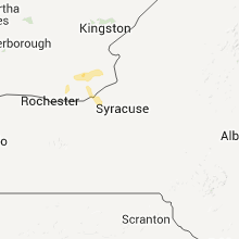
| 3:33 PM UTC | Golf Ball sized hail reported near Nyack, NY, 27.6 miles N of Brooklyn, NY, golf ball sized hail |
| 4:02 PM UTC | Tree down on whippoorwill crossin in westchester county NY, 33.6 miles NNE of Brooklyn, NY |
Connecticut
| Local Time | Report Details |
|---|---|
| 5:20 PM UTC | *** 1 in fairfield county CT, 31.9 miles NE of Brooklyn, NY |
| 5:20 PM UTC | *** 1 fatal *** tree down on car at the intersection of merritt parkway and county route 10 in fairfield county CT, 31.9 miles NE of Brooklyn, NY |
Kentucky
| Local Time | Report Details |
|---|---|
| 6:03 PM UTC | Several trees and power lines down. tree blown on house. roofs and barns heavily damaged. all damage confined to a two mile radius of jud in montgomery county KY, 29.7 miles N of Irvine, KY |
| 7:42 PM UTC | Tree down on power lines in boyd county KY, 57.7 miles W of Charleston, WV |
| 8:08 PM UTC | Trees down at england hill 6000 block sr3 in boyd county KY, 52.3 miles W of Charleston, WV |
| 10:20 PM UTC | Numerous trees down along horse creek roa in clay county KY, 42.7 miles S of Irvine, KY |
| 10:46 PM UTC | Few trees down on cemetery roa in clay county KY, 46 miles SSE of Irvine, KY |
| 11:00 PM UTC | Several trees down throughout are in boyd county KY, 56.6 miles W of Charleston, WV |
| 11:40 PM UTC | Several trees down in ashland area and throughout count in boyd county KY, 54.9 miles W of Charleston, WV |
| 11:52 PM UTC | Trees down along cow branch rd off hwy172 and also hwy772 at mm6. time est from rada in morgan county KY, 44 miles ENE of Irvine, KY |
| 12:30 AM UTC | Quarter sized hail reported near Stambaugh, KY, 65.5 miles ENE of Irvine, KY, spotter reported hail up to 1 inch |
South Carolina
| Local Time | Report Details |
|---|---|
| 6:21 PM UTC | Trees down along i-26 near mile marker 11 in lexington county SC, 63 miles ENE of Augusta, GA |
| 6:28 PM UTC | Quarter sized hail reported near , , 65.2 miles NE of Augusta, GA, skywarn observer reports quarter sized hail garners ferry road near trotter rd. |
| 6:35 PM UTC | Multiple reports of trees down along leesburg rd in richland county SC, 72.3 miles NW of Charleston, SC |
| 6:45 PM UTC | Trees down on country club rd in edgefield county SC, 24 miles NNE of Augusta, GA |
| 7:05 PM UTC | Schp reported trees down along us highway 521 in sumter county SC, 66.7 miles NNW of Charleston, SC |
| 7:23 PM UTC | Trees down on woodrow rd in lee county SC, 65.8 miles NNW of Charleston, SC |
| 7:38 PM UTC | Trees down on st charles hwy in lee county SC, 66.2 miles N of Charleston, SC |
| 7:48 PM UTC | Numerous trees dow reported in lama in darlington county SC, 67.2 miles N of Charleston, SC |
| 8:16 PM UTC | Trees...up to 12 inches in diameter reportedly down near the intersection of south charleston highway and pocket roa in darlington county SC, 76.6 miles N of Charleston, SC |
| 8:28 PM UTC | A few trees reported down within the sampit are in georgetown county SC, 34.2 miles ENE of Charleston, SC |
| 9:15 PM UTC | Trees down near grady road and highway 4 in marion county SC, 74.6 miles NNE of Charleston, SC |
| 9:15 PM UTC | Several trees down just off sandhill roa in williamsburg county SC, 43 miles NE of Charleston, SC |
| 9:30 PM UTC | Half Dollar sized hail reported near Myrtle Beach, SC, 67.2 miles ENE of Charleston, SC, half dollar sized hail reported at hwy 544 and sc 31. |
| 9:31 PM UTC | Large tree limbs down at hwy 544 and sc 3 in horry county SC, 67.2 miles ENE of Charleston, SC |
| 9:34 PM UTC | Half Dollar sized hail reported near Myrtle Beach, SC, 67.2 miles ENE of Charleston, SC |
| 9:35 PM UTC | Quarter sized hail reported near Conway, SC, 69.5 miles WSW of Wilmington, NC, quarter sized hail reported near hwy 544. |
| 9:35 PM UTC | Quarter sized hail reported near Conway, SC, 68.2 miles WSW of Wilmington, NC, quarter sized hail at hwy 344 and sc 31. |
| 9:35 PM UTC | Large tree down at recycle center near hwy 544 and sc 3 in horry county SC, 68.2 miles WSW of Wilmington, NC |
| 9:36 PM UTC | Numerous trees were reportedly down in carolina forest. the time was estimated based on rada in horry county SC, 69.2 miles ENE of Charleston, SC |
| 9:40 PM UTC | Tree down on a vehicl in berkeley county SC, 14.9 miles S of Charleston, SC |
| 9:45 PM UTC | Trees down on peachtree r in horry county SC, 66.7 miles ENE of Charleston, SC |
| 9:54 PM UTC | Atleast 15 pine trees down...snapped and uprooted. large shopping center sign and large fences blown down. all along hwy 501 near carolina forest blvd and gardner lacy in horry county SC, 66.8 miles WSW of Wilmington, NC |
| 9:55 PM UTC | Report of trees down on live oak church r in horry county SC, 58.1 miles W of Wilmington, NC |
| 10:00 PM UTC | Tree down on rail bed roa in beaufort county SC, 39.9 miles NNE of Savannah, GA |
| 10:00 PM UTC | Tree down at ritter road and catholic hill road in colleton county SC, 47.3 miles SW of Charleston, SC |
| 10:00 PM UTC | Two single engine airplanes flipped over at conway airport. one airplane was carried over 100 f in horry county SC, 67.6 miles NE of Charleston, SC |
| 10:05 PM UTC | Trees down in seabrook and grays hill in beaufort county SC, 36.2 miles NNE of Savannah, GA |
| 10:45 PM UTC | 2 trres down in westcott plantatio in dorchester county SC, 18.1 miles SSW of Charleston, SC |
| 10:50 PM UTC | Several trees reported down along roadways in the ravenel area. time estimated based on rada in charleston county SC, 33.1 miles SSW of Charleston, SC |
| 10:50 PM UTC | 1 large limb down along appian wa in dorchester county SC, 20.7 miles SSW of Charleston, SC |
| 10:51 PM UTC | 3 large limbs down. 8 to 10 inches in diamete in berkeley county SC, 20.6 miles SSE of Charleston, SC |
| 11:03 PM UTC | Several trees reported down along highway 61 near the west ashley area. time estimated based on rada in charleston county SC, 25.9 miles S of Charleston, SC |
Georgia
| Local Time | Report Details |
|---|---|
| 6:30 PM UTC | Numerous trees down and a few powerlines dow in charlton county GA, 40.3 miles NNW of Jacksonville, FL |
| 7:06 PM UTC | Nws incident meteorologist on site at the honey prairie wildfire complex reported widespread tree damage at the east entrace of the okefenokee nw in charlton county GA, 41.2 miles NNW of Jacksonville, FL |
| 7:15 PM UTC | Public report of 60 mph winds in folksto in charlton county GA, 40.9 miles NNW of Jacksonville, FL |
| 7:55 PM UTC | Trees and power lines were blown down at exit 7 off of interstate 95 in kingsland. the time of the damage was based on rada in camden county GA, 32.3 miles N of Jacksonville, FL |
| 8:00 PM UTC | Trees and powerlines reported dow in camden county GA, 31.7 miles NNE of Jacksonville, FL |
| 8:05 PM UTC | Public report of a shed blown down on harriets bluff r in camden county GA, 35.7 miles N of Jacksonville, FL |
| 8:10 PM UTC | Spotter reported 2 trees down in the kingsland are in camden county GA, 32.3 miles N of Jacksonville, FL |
| 8:15 PM UTC | Emergency manager reported 15 trees and some powerlines down south of jesup along ga highway 2 in wayne county GA, 56.4 miles SW of Savannah, GA |
| 8:39 PM UTC | Montgomery 911 relayed a report of a tree down near uvald in montgomery county GA, 43.4 miles NNE of Douglas, GA |
| 9:05 PM UTC | Large tree branches down. 6 inch drawbridge gate broken on the islands expressway in chatham county GA, 5.2 miles ESE of Savannah, GA |
| 9:08 PM UTC | Tree fell on car. damage unknown. time estimated based on rada in chatham county GA, 8.4 miles ESE of Savannah, GA |
| 9:08 PM UTC | Numerous reports of trees down across northern lowndes count in lowndes county GA, 45 miles SSW of Douglas, GA |
| 9:19 PM UTC | Several trees reported down in and north of ray city. time estimated by rada in berrien county GA, 34.8 miles SW of Douglas, GA |
| 9:20 PM UTC | Several trees reported down across lanier county. time estimated by rada in lanier county GA, 34.6 miles SSW of Douglas, GA |
| 9:26 PM UTC | The public reported the north bound lane of mcwhorter drive on skidaway island is blocked by tree damage. time estimated based on rada in chatham county GA, 10.7 miles SSE of Savannah, GA |
| 9:28 PM UTC | Trees down. roof and chimney sustained damage due to falling trees. time estimated based on rada in chatham county GA, 10.1 miles SSE of Savannah, GA |
| 9:35 PM UTC | Tree down on a power in in bulloch county GA, 50.9 miles WNW of Savannah, GA |
| 9:52 PM UTC | Tree down near black creek churc in bulloch county GA, 35.1 miles WNW of Savannah, GA |
| 10:07 PM UTC | Trees were blown down along route 17. time was estimated from rada in effingham county GA, 24.1 miles NW of Savannah, GA |
| 11:12 PM UTC | One tree down along highway 99. time estimated based on rada in mcintosh county GA, 43.5 miles SSW of Savannah, GA |
Florida
| Local Time | Report Details |
|---|---|
| 6:52 PM UTC | A couple of trees down and powerlines down in the la crosse area. time estimated based on rada in alachua county FL, 56 miles SW of Jacksonville, FL |
| 7:35 PM UTC | Trees and powerlines reported down. hail up to penny size also reported. time of event based on rada in alachua county FL, 66 miles SSW of Jacksonville, FL |
| 7:55 PM UTC | Public report of trees down along interstate 10 at mile marker 34 in duval county FL, 21.4 miles W of Jacksonville, FL |
| 8:10 PM UTC | Trees were blown down along beaver street between otis road and baldwin. the time of the event was based on rada in duval county FL, 14.7 miles W of Jacksonville, FL |
| 8:15 PM UTC | A nws employee reported trees down in his community. a trampoline was blown over a fenc in duval county FL, 10.7 miles WNW of Jacksonville, FL |
| 8:50 PM UTC | Lehigh acres middle school weather station reported a wind gust of 61 mph. time estimate in lee county FL, 33.4 miles NNE of Naples, FL |
| 8:55 PM UTC | Spotter has reported tress down around his neighborhood near lehigh high acre in lee county FL, 34.2 miles NNE of Naples, FL |
| 9:09 PM UTC | A spotter reported thunderstorm wind gusts of 60 mph with dime size hail which lasted 10 minutes near bakersvill in st. johns county FL, 30.7 miles SSE of Jacksonville, FL |
| 11:55 PM UTC | Polk county em relayed report of a large tree down in north ft meade. numerous branches down along hwy 17. street flooding in the city limit in polk county FL, 51.1 miles ENE of Bradenton, FL |
Montana
| Local Time | Report Details |
|---|---|
| 7:00 PM UTC | Half Dollar sized hail reported near Kalispell, MT, 16.5 miles SE of Whitefish, MT, spotter reported some shingle damage and dents in copper roofing. |
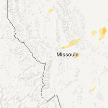
| 7:45 PM UTC | Half Dollar sized hail reported near Bonner, MT, 30.5 miles ENE of Missoula, MT, hail reported at big sky lake. |
| 7:50 PM UTC | Quarter sized hail reported near Bonner, MT, 30.7 miles ENE of Missoula, MT, public report from salmon lake area |
| 7:50 PM UTC | Half Dollar sized hail reported near Bonner, MT, 30.5 miles ENE of Missoula, MT, hail reported at big sky lake. |
| 9:05 PM UTC | 50-60 mph winds reported with a thunderstorm...along with pea sized hail and 0.30 inches of brief heavy rainfal in lewis and clark county MT, 52.2 miles W of Great Falls, MT |
| 9:40 PM UTC | Golf Ball sized hail reported near Fort Shaw, MT, 23.6 miles W of Great Falls, MT, golf ball sized hail was reported along the us89 near fort shaw |
| 9:55 PM UTC | Winds estimated at 60-70 mph at onset of storm with breif heavy rain and pea sized hail in teton county MT, 23.6 miles WNW of Great Falls, MT |
| 10:00 PM UTC | A metal roof was blown off a trailer or shed in the northern portion of great falls. the roof made contact with a power line and witnesses reported that it triggered so in cascade county MT, 0.9 miles ESE of Great Falls, MT |
| 11:04 PM UTC | Yellow mule raws station elevation 9200 feet in gallatin county MT, 38.4 miles SSW of Bozeman, MT |
| 12:05 AM UTC | 59 mph wind gust observed at the havre airport aso in hill county MT, 4.2 miles WSW of Havre, MT |
| 2:01 AM UTC | Quarter sized hail reported near Malta, MT, 68.6 miles ENE of Havre, MT |
| 2:35 AM UTC | Storm damage reported in phillips county MT, 49 miles WNW of Glasgow, MT |
| 2:55 AM UTC | 0.50 inches of rain in phillips county MT, 50.1 miles NW of Glasgow, MT |
| 3:25 AM UTC | Winds sustained 50-60 mp in garfield county MT, 60.5 miles S of Glasgow, MT |
| 4:40 AM UTC | Winds estimated at 60 mph with a 12 ft fence blown dow in treasure county MT, 66.5 miles W of Miles City, MT |
Ohio
| Local Time | Report Details |
|---|---|
| 7:15 PM UTC | Trees dow in harrison county OH, 55.9 miles WSW of Pittsburgh, PA |
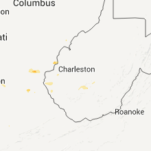
| 7:45 PM UTC | Numerous tree branches down. one larg in lawrence county OH, 51.1 miles WNW of Charleston, WV |
| 11:00 PM UTC | Trees down on pleasant hill road in athens county OH, 65.4 miles SE of Columbus, OH |
| 11:30 PM UTC | Tree dow in belmont county OH, 51.3 miles SW of Pittsburgh, PA |
West Virginia
| Local Time | Report Details |
|---|---|
| 7:34 PM UTC | Trees down. house collapsed not sure what caused i in wayne county WV, 51.2 miles W of Charleston, WV |
| 8:24 PM UTC | Tree branches down in cabell county WV, 23.5 miles W of Charleston, WV |
| 9:10 PM UTC | Numerous trees and power lines down along lick creek roa in boone county WV, 22.5 miles SW of Charleston, WV |
| 9:30 PM UTC | Trees down at observer home. nickel size hai in wayne county WV, 48.7 miles WSW of Charleston, WV |
| 1:24 AM UTC | Trees down on route 119 near lucado road in kanawha county WV, 0.5 miles E of Charleston, WV |
Tennessee
| Local Time | Report Details |
|---|---|
| 9:05 PM UTC | Roof off mobile in pickett county TN, 80.6 miles WNW of Knoxville, TN |
| 9:40 PM UTC | Trees down across southern portion of count in overton county TN, 81.2 miles E of Nashville, TN |
| 9:45 PM UTC | Trees down on hwy 42 near rigman road blocked temporarily in overton county TN, 79.5 miles WNW of Knoxville, TN |
| 10:40 PM UTC | One tree down on leatherwood rd and one down on pine hill r in scott county TN, 53.5 miles NW of Knoxville, TN |
| 10:55 PM UTC | A couple of trees down in the sunbright are in morgan county TN, 46.1 miles WNW of Knoxville, TN |
| 12:09 AM UTC | Two trees down on maple drive in knox county TN, 6.4 miles NNW of Knoxville, TN |
| 12:10 AM UTC | Couple of trees down on oliver springs highwa in anderson county TN, 15.4 miles WNW of Knoxville, TN |
| 12:34 AM UTC | A couple of trees down on tillery and reaves rd in knox county TN, 6 miles NW of Knoxville, TN |
| 6:05 AM UTC | Several trees down across the southern third of the county. reported by dispatc in jefferson county TN, 31.4 miles E of Knoxville, TN |
| 7:33 AM UTC | Power lines down on boyds creek highwa in sevier county TN, 15.2 miles E of Knoxville, TN |
| 7:35 AM UTC | Numerous trees down across the southern third of the county. reported by dispatc in jefferson county TN, 30.4 miles E of Knoxville, TN |
Idaho
| Local Time | Report Details |
|---|---|
| 1:11 AM UTC | Hen Egg sized hail reported near Montpelier, ID, 89.2 miles SSE of Idaho Falls, ID |
| 1:12 AM UTC | Quarter sized hail reported near Montpelier, ID, 88 miles SSE of Idaho Falls, ID, still falling at time of observation. |
| 1:12 AM UTC | Golf Ball sized hail reported near Montpelier, ID, 94.3 miles SSE of Idaho Falls, ID, some hail slightly larger than golf ball. |
Oklahoma
| Local Time | Report Details |
|---|---|
| 2:03 AM UTC | Storm damage reported in dewey county OK, 48 miles SSE of Woodward, OK |
| 4:59 AM UTC | Quarter sized hail reported near Talala, OK, 31.3 miles NE of Tulsa, OK |
Wyoming
| Local Time | Report Details |
|---|---|
| 2:53 AM UTC | Storm damage reported in carbon county WY, 87.1 miles SSW of Casper, WY |
| 3:33 AM UTC | 2 large old and healthy trees were uprooted. one went through a farm shop and the other through a she in fremont county WY, 2.6 miles NW of Riverton, WY |
Arkansas
| Local Time | Report Details |
|---|---|
| 8:50 AM UTC | Downed trees. time estimated via radar. also hail to half dollars reporte in benton county AR, 55.9 miles N of Fort Smith, AR |
Missouri
| Local Time | Report Details |
|---|---|
| 11:25 AM UTC | Quarter sized hail reported near Macks Creek, MO, 56.5 miles NNE of Springfield, MO, quarter size hail reported at the intersection of highway 54 and highway j. |
Connect with Interactive Hail Maps