

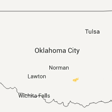
Hail Map for Wednesday, June 29, 2011

Number of Impacted Households on 6/29/2011
0
Impacted by 1" or Larger Hail
0
Impacted by 1.75" or Larger Hail
0
Impacted by 2.5" or Larger Hail
Square Miles of Populated Area Impacted on 6/29/2011
0
Impacted by 1" or Larger Hail
0
Impacted by 1.75" or Larger Hail
0
Impacted by 2.5" or Larger Hail


Cities Most Affected by Hail Storms of 6/29/2011
| Hail Size | Demographics of Zip Codes Affected | ||||||
|---|---|---|---|---|---|---|---|
| City | Count | Average | Largest | Pop Density | House Value | Income | Age |
| Glasgow, MT | 6 | 1.88 | 2.00 | 2 | $65k | $32.3k | 45.9 |
| Malta, MT | 2 | 2.25 | 2.75 | 0 | $64k | $31.5k | 46.6 |
| Fort Peck, MT | 1 | 2.00 | 2.00 | 0 | $86k | $44.6k | 52.6 |
| Hinsdale, MT | 1 | 2.00 | 2.00 | 0 | $42k | $23.2k | 46.3 |
| Wrightsville Beach, NC | 1 | 1.75 | 1.75 | 1197 | $488k | $55.4k | 35.5 |
| Frazer, MT | 1 | 1.75 | 1.75 | 1 | $29k | $24.1k | 28.3 |
Hail and Wind Damage Spotted on 6/29/2011
Filter by Report Type:Hail ReportsWind Reports
States Impacted
Wyoming, Idaho, North Carolina, Utah, Montana, Maine, Louisiana, Colorado, Arizona, Nebraska, New MexicoWyoming
| Local Time | Report Details |
|---|---|
| 6:15 PM UTC | *** 3 inj *** dmg occurred at jackson lake lodge. winds blew out large windows. blew down in teton county WY, 73.1 miles ENE of Idaho Falls, ID |
| 12:21 AM UTC | Storm damage reported in albany county WY, 19.4 miles SW of Laramie, WY |
| 12:33 AM UTC | Storm damage reported in albany county WY, 0.5 miles E of Laramie, WY |
| 12:41 AM UTC | Storm damage reported in carbon county WY, 87.1 miles SSW of Casper, WY |
| 1:15 AM UTC | Late report. time estimated based on rada in laramie county WY, 24.2 miles E of Laramie, WY |
Idaho
| Local Time | Report Details |
|---|---|
| 7:05 PM UTC | Eight large wooden power poles were snapped off near th in fremont county ID, 42.3 miles NE of Idaho Falls, ID |
| 9:22 PM UTC | Storm damage reported in bear lake county ID, 96.2 miles NNE of Salt Lake City, UT |
| 9:27 PM UTC | Storm damage reported in bear lake county ID, 87 miles SSE of Idaho Falls, ID |
| 11:54 PM UTC | Big trre blown down in bear lake county ID, 96.2 miles NNE of Salt Lake City, UT |
North Carolina
| Local Time | Report Details |
|---|---|
| 7:39 PM UTC | Observed by wx station located at 102 n. shore drive at surf city tourism and info cente in pender county NC, 25.5 miles ENE of Wilmington, NC |
| 4:15 PM EDT | Golf Ball sized hail reported near Wrightsville Beach, NC, 8.7 miles ESE of Wilmington, NC, golf ball hail reported at wings on wrightsville beach |
| 4:27 PM EDT | Tree down across henry h watters drive. time estimated based off rada in new hanover county NC, 3.7 miles SSE of Wilmington, NC |
| 4:30 PM EDT | Measured at the nc state port in wilmington in new hanover county NC, 2.4 miles S of Wilmington, NC |
| 4:30 PM EDT | Multiple reports of damage at the nc state port in wilmingto in new hanover county NC, 2.4 miles S of Wilmington, NC |
| 9:00 PM UTC | Tree down near the intersection of wrightsville avenue and oleander drive. time estimated based off radar in new hanover county NC, 6.7 miles E of Wilmington, NC |
| 9:09 PM UTC | Large tree down near the 5600 block of oleander drive. time estimated based off radar in new hanover county NC, 5.8 miles ESE of Wilmington, NC |
| 9:14 PM UTC | Tree down at 5600 park avenue in new hanover county NC, 5.8 miles ESE of Wilmington, NC |
| 9:14 PM UTC | Tree down at 5600 park avenue. time estimated based off radar in new hanover county NC, 5.8 miles ESE of Wilmington, NC |
Utah
| Local Time | Report Details |
|---|---|
| 7:40 PM UTC | Baccus/sr111 senso in salt lake county UT, 12.7 miles SW of Salt Lake City, UT |
| 7:44 PM UTC | Faa sensor at the salt lake city international airpor in salt lake county UT, 5.3 miles WNW of Salt Lake City, UT |
| 7:46 PM UTC | Salt lake city international airport aso in salt lake county UT, 4.5 miles WNW of Salt Lake City, UT |
| 7:50 PM UTC | Sr-12 at boulder summit s in garfield county UT, 59.2 miles SE of Monroe, UT |
| 8:00 PM UTC | Center tailings c in salt lake county UT, 12.7 miles W of Salt Lake City, UT |
| 8:00 PM UTC | A russian olive tree was knocked over at the north side of the salt lake city international airport and fell on a building. reported by airport operation in salt lake county UT, 6.5 miles WNW of Salt Lake City, UT |
| 8:11 PM UTC | West ogden cwop s in weber county UT, 37.6 miles NNW of Salt Lake City, UT |
| 8:45 PM UTC | Otter creek raw in rich county UT, 75.3 miles NNE of Salt Lake City, UT |
| 8:45 PM UTC | The rich county sheriff reported that a large tree was knocked over in woodruf in rich county UT, 64.8 miles NE of Salt Lake City, UT |
| 9:37 PM UTC | Price aso in carbon county UT, 3.3 miles E of Price, UT |
| 9:50 PM UTC | Lake point at i-80 s in tooele county UT, 20.1 miles WSW of Salt Lake City, UT |
| 10:17 PM UTC | Flattop mountain in emery county UT, 21.2 miles SSE of Price, UT |
| 11:05 PM UTC | Logan aso in cache county UT, 70.5 miles N of Salt Lake City, UT |
Montana
| Local Time | Report Details |
|---|---|
| 8:11 PM UTC | 59 mph wind gust at the dot sensor near elk par in jefferson county MT, 75.1 miles WNW of Bozeman, MT |
| 9:05 PM UTC | 61 mph thunderstorm wind gust at the elkhorn raws location. time is estimated off rada in broadwater county MT, 60.9 miles NNW of Bozeman, MT |
| 10:15 PM UTC | Storm damage reported in beaverhead county MT, 30.3 miles ENE of Salmon, ID |
| 11:27 PM UTC | 58 mph wind gust at the havre airpor in hill county MT, 4.2 miles WSW of Havre, MT |
| 12:25 AM UTC | Storm damage reported in phillips county MT, 58 miles WNW of Glasgow, MT |
| 12:25 AM UTC | Baseball sized hail reported near Malta, MT, 67.6 miles W of Glasgow, MT, estimated baseball size hail knocking horses over. |
| 12:52 AM UTC | Golf Ball sized hail reported near Malta, MT, 44.4 miles WSW of Glasgow, MT, estimated golf ball sized hail. |
| 1:09 AM UTC | 65 mph gust recorded at this location. winds got stronger destroying the wind gage. the winds knocked down trees and damaged two 50 year old garages. the winds blew awa in phillips county MT, 38.2 miles NW of Glasgow, MT |
| 1:09 AM UTC | Quarter sized hail reported near Saco, MT, 38.2 miles NW of Glasgow, MT, estimated quarter sized hail. 65 mph wind. |
| 1:09 AM UTC | Quarter sized hail reported near Saco, MT, 49 miles WNW of Glasgow, MT, estimated quarter sized hail. 70 mph wind. visibility less than 50 feet. |
| 1:14 AM UTC | Estimated 61 mph winds in valley county MT, 32.9 miles NW of Glasgow, MT |
| 1:40 AM UTC | Golf Ball sized hail reported near Glasgow, MT, 0.4 miles NNW of Glasgow, MT, 1.75 inch hail reported with 65 mph winds. |
| 1:40 AM UTC | Golf Ball sized hail reported near Glasgow, MT, 0.4 miles SSW of Glasgow, MT, golf ball size hail. small tree limbs down est 50-60 mph winds. |
| 1:40 AM UTC | Hen Egg sized hail reported near Glasgow, MT, 0.5 miles NE of Glasgow, MT, 2 inch hail reported by a trained spotter. |
| 1:42 AM UTC | Ping Pong Ball sized hail reported near Glasgow, MT, 0.4 miles NNW of Glasgow, MT, estimated 1 1/2 inch hail. |
| 1:42 AM UTC | Hen Egg sized hail reported near Fort Peck, MT, 6.2 miles W of Glasgow, MT, estimated 2 inch hail. |
| 1:45 AM UTC | Hen Egg sized hail reported near Glasgow, MT, 0.4 miles NNW of Glasgow, MT, measured 2 inch hail. |
| 1:48 AM UTC | Hen Egg sized hail reported near Glasgow, MT, 0.4 miles NNW of Glasgow, MT, measured 2 1/4 inch hail at the office. |
| 1:53 AM UTC | Golf Ball sized hail reported near Glasgow, MT, 0.4 miles NNW of Glasgow, MT, estimated 1 3/4 inch hail and 65 mph wind. |
| 2:05 AM UTC | Quarter sized hail reported near Hinsdale, MT, 18.7 miles NW of Glasgow, MT, quarter size hail reported |
| 2:05 AM UTC | Hen Egg sized hail reported near Hinsdale, MT, 19.1 miles NW of Glasgow, MT, estimated 2 inch hail. measured 0.70 inches of precip in 45 minutes. |
| 2:20 AM UTC | 3 fencing panels blown down. numerous small limbs blown from trees. one small tree blown down. shingles blown of in valley county MT, 33.6 miles NE of Glasgow, MT |
| 2:28 AM UTC | Golf Ball sized hail reported near Frazer, MT, 30.7 miles ENE of Glasgow, MT, estimated golf ball sized hail. |
| 2:30 AM UTC | Estimated 60 mph wind. small trees down. large limbs dow in valley county MT, 33.6 miles NE of Glasgow, MT |
| 2:44 AM UTC | Measured 62 mph gust at king coulee raws statio in valley county MT, 34.8 miles SW of Glasgow, MT |
| 3:36 AM UTC | Measured 60 mph wind. heavy rain. no hai in daniels county MT, 79.6 miles NW of Williston, ND |
| 3:50 AM UTC | Quarter sized hail reported near Reserve, MT, 66.5 miles WNW of Williston, ND, estimated 1 inch hail. heavy rain. |
| 4:07 AM UTC | Quarter sized hail reported near Plentywood, MT, 60.9 miles NW of Williston, ND, 50-60 mph estimated winds as well...also reported one power line down and a tree branch broke a rear window of a vehicle |
Maine
| Local Time | Report Details |
|---|---|
| 8:30 PM UTC | Trees on wires reported by farmington police in franklin county ME, 68.5 miles W of Bangor, ME |
Louisiana
| Local Time | Report Details |
|---|---|
| 9:30 PM UTC | Trees were blown down near the intersection of u.s. highway 61 and louisiana highway 54. one tree fell on a busines in st. john the bapti county LA, 33.7 miles WNW of New Orleans, LA |
Colorado
| Local Time | Report Details |
|---|---|
| 9:49 PM UTC | Storm damage reported in denver county CO, 19.3 miles ENE of Denver, CO |
| 12:14 AM UTC | Storm damage reported in larimer county CO, 27.8 miles SSW of Laramie, WY |
| 1:08 AM UTC | Storm damage reported in rio blanco county CO, 37.4 miles SSW of Craig, CO |
Arizona
| Local Time | Report Details |
|---|---|
| 12:03 AM UTC | Recorded by guthrie raw in greenlee county AZ, 58 miles WNW of Silver City, NM |
| 12:06 AM UTC | Recorded at the bisbee-douglas international airpor in cochise county AZ, 0.8 miles ESE of Douglas, AZ |
| 10:50 AM UTC | Tree upr in pima county AZ, 3.4 miles SSW of Tucson, AZ |
| 10:50 AM UTC | Tree uprooted... tree toppled over and minor roof damage to apartment build in the mission drexel heights area in pima county AZ, 3.4 miles SSW of Tucson, AZ |
Nebraska
| Local Time | Report Details |
|---|---|
| 1:16 AM UTC | Brief heavy rain and pea-sized hail accompanied wind gus in cheyenne county NE, 59.7 miles ESE of Scottsbluff, NE |
New Mexico
| Local Time | Report Details |
|---|---|
| 4:12 AM UTC | Kfmn aso in san juan county NM, 1.7 miles NNW of Farmington, NM |
Connect with Interactive Hail Maps