

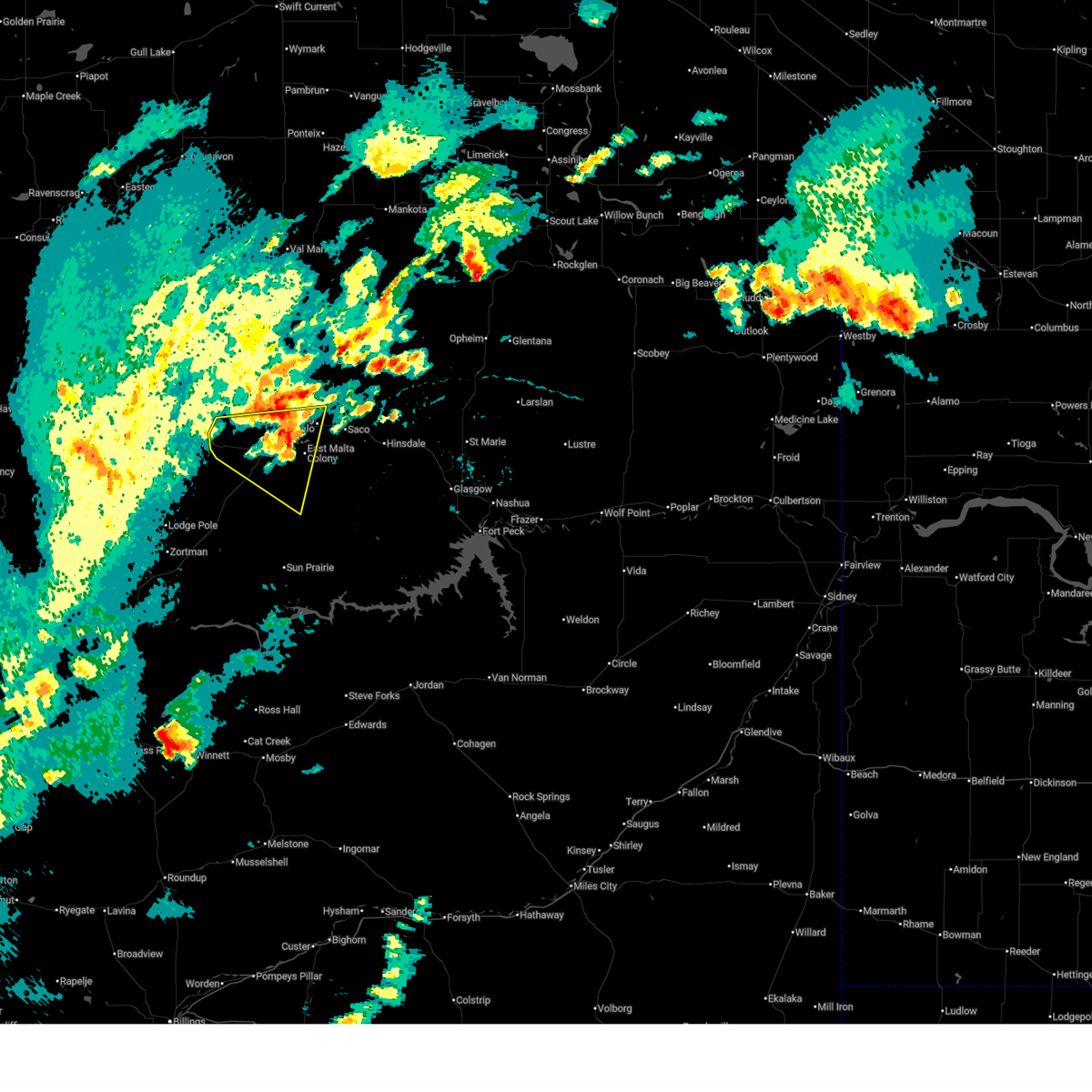
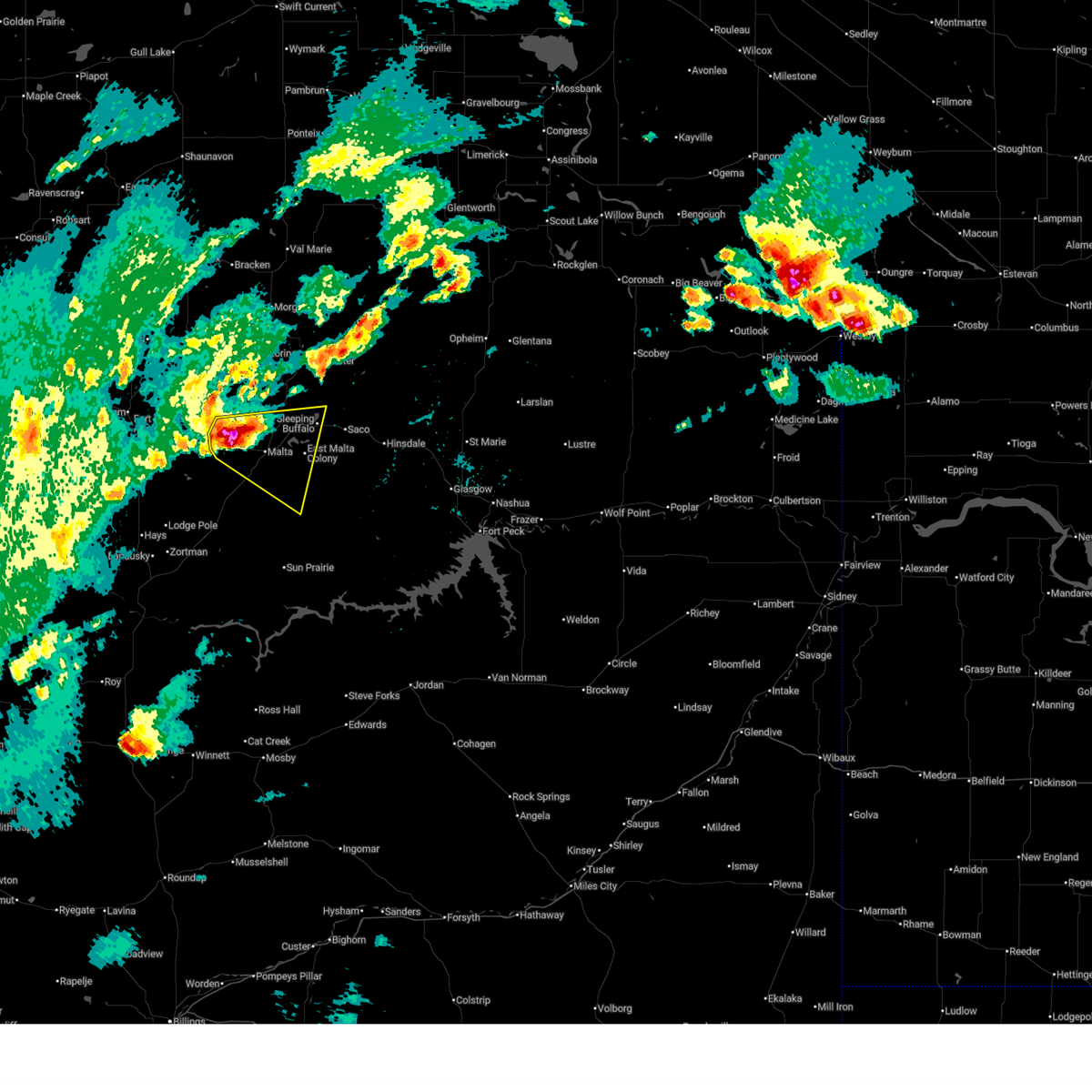
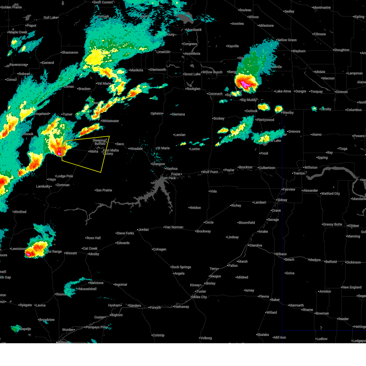
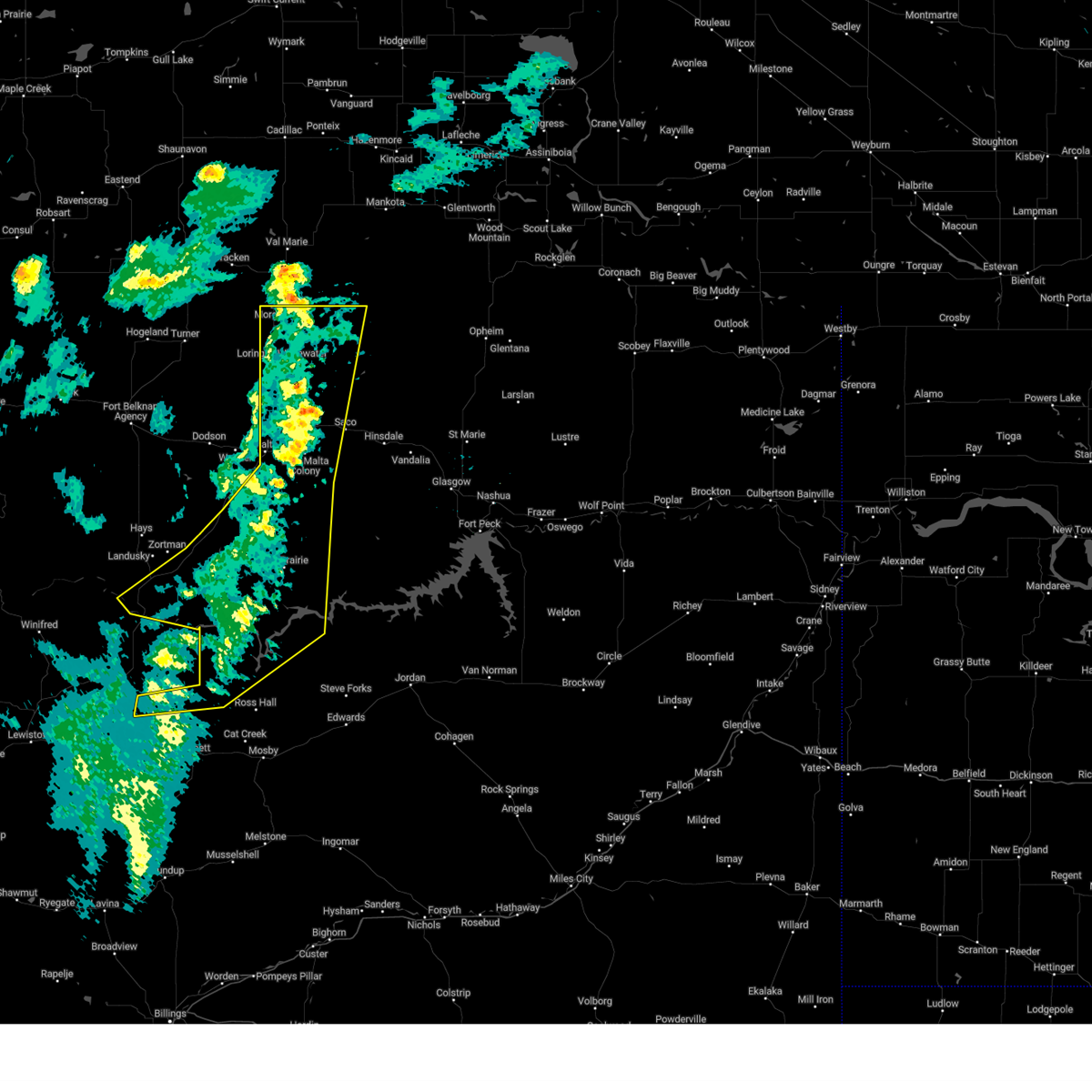
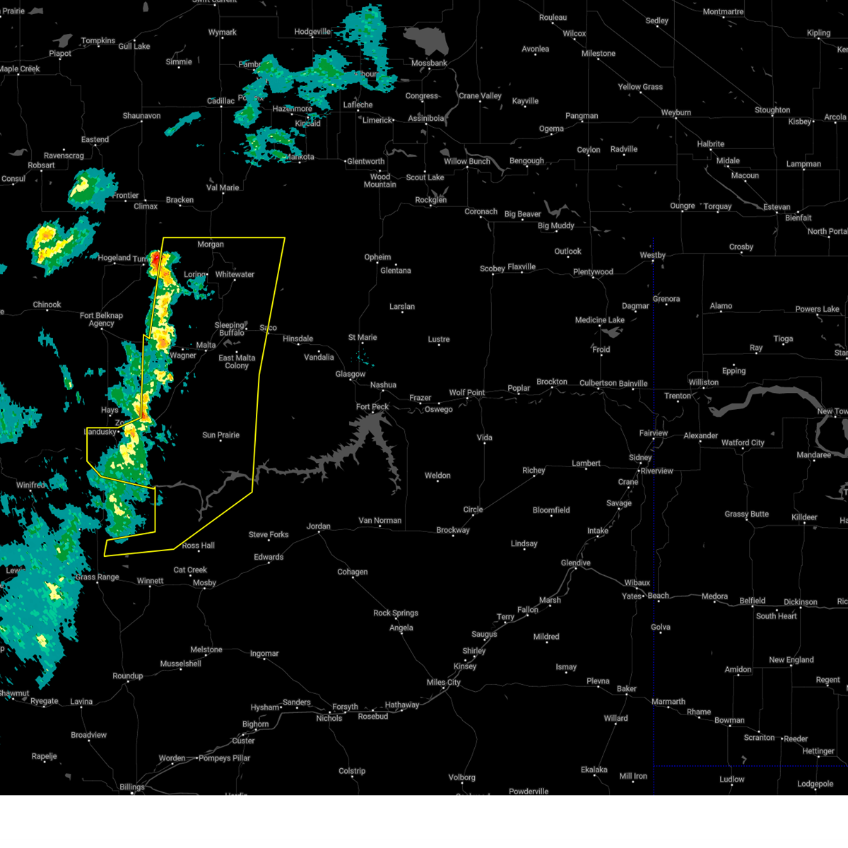
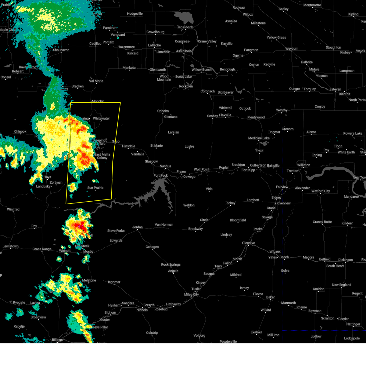
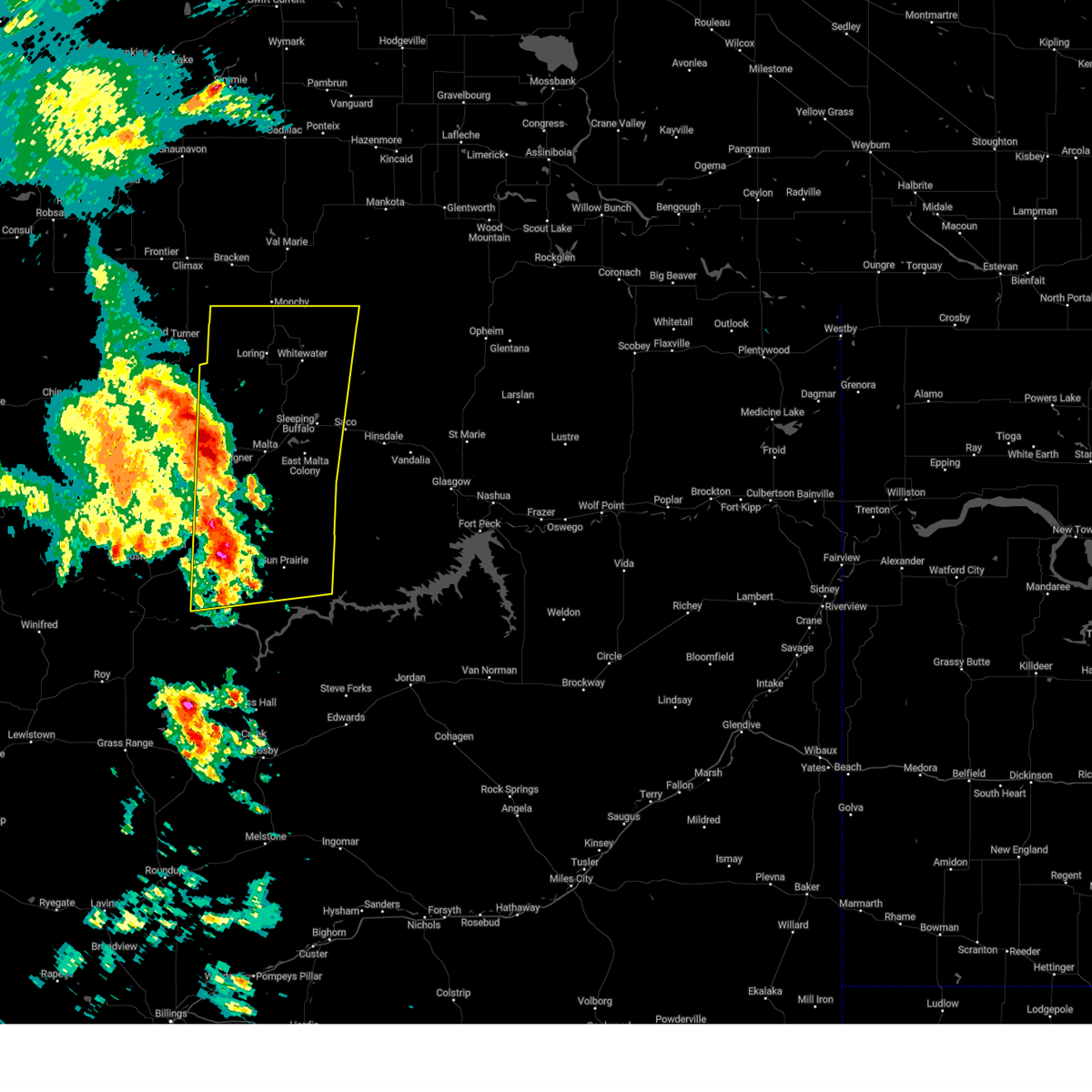
Hail Map for Malta, MT
The Malta, MT area has had 24 reports of on-the-ground hail by trained spotters, and has been under severe weather warnings 11 times during the past 12 months. Doppler radar has detected hail at or near Malta, MT on 21 occasions, including 1 occasion during the past year.
| Name: | Malta, MT |
| Where Located: | 58 miles W of Glasgow, MT |
| Map: | Google Map for Malta, MT |
| Population: | 1997 |
| Housing Units: | 1006 |
| More Info: | Search Google for Malta, MT |
3
The Top Recent Hail Date for Malta, MT is Friday, September 20, 2024 (2nd out of 21)

Hail and Wind Damage Spotted near Malta, MT
| Date / Time | Report Details |
|---|---|
| 7/2/2025 8:10 PM MDT | Saco s (hydromet) statio in phillips county MT, 22.7 miles WNW of Malta, MT |
| 7/2/2025 7:30 PM MDT | Multiple cottonwood trees have limb damage... wicked lightning... estimated winds 55-60 mph... lots of rai in phillips county MT, 35.9 miles N of Malta, MT |
| 6/15/2025 6:25 PM MDT |
 The storm which prompted the warning has weakened below severe limits, and has exited the warned area. therefore, the warning will be allowed to expire. however, gusty winds are still possible with this thunderstorm. a severe thunderstorm watch remains in effect until 1100 pm mdt for northeastern montana. The storm which prompted the warning has weakened below severe limits, and has exited the warned area. therefore, the warning will be allowed to expire. however, gusty winds are still possible with this thunderstorm. a severe thunderstorm watch remains in effect until 1100 pm mdt for northeastern montana.
|
| 6/15/2025 6:04 PM MDT |
 At 603 pm mdt, a severe thunderstorm was located 5 miles northwest of malta, moving east at 35 mph (radar indicated). Hazards include 60 mph wind gusts and quarter size hail. Hail damage to vehicles is expected. expect wind damage to roofs, siding, and trees. Locations impacted include, bowdoin, sleeping buffalo, wagner, malta, and dodson. At 603 pm mdt, a severe thunderstorm was located 5 miles northwest of malta, moving east at 35 mph (radar indicated). Hazards include 60 mph wind gusts and quarter size hail. Hail damage to vehicles is expected. expect wind damage to roofs, siding, and trees. Locations impacted include, bowdoin, sleeping buffalo, wagner, malta, and dodson.
|
| 6/15/2025 6:00 PM MDT | Spotter reported pea sized hail... heavy rain... and winds winds 50 to 60 mph estimate in phillips county MT, 13.3 miles E of Malta, MT |
| 6/15/2025 5:27 PM MDT |
 Svrggw the national weather service in glasgow has issued a * severe thunderstorm warning for, central phillips county in northeastern montana, * until 630 pm mdt. * at 525 pm mdt, a severe thunderstorm was located 10 miles southwest of dodson, or 26 miles west of malta, moving east at 40 mph (radar indicated). Hazards include 60 mph wind gusts and quarter size hail. Hail damage to vehicles is expected. Expect wind damage to roofs, siding, and trees. Svrggw the national weather service in glasgow has issued a * severe thunderstorm warning for, central phillips county in northeastern montana, * until 630 pm mdt. * at 525 pm mdt, a severe thunderstorm was located 10 miles southwest of dodson, or 26 miles west of malta, moving east at 40 mph (radar indicated). Hazards include 60 mph wind gusts and quarter size hail. Hail damage to vehicles is expected. Expect wind damage to roofs, siding, and trees.
|
| 5/10/2025 7:50 PM MDT | Saco s (hydromet) in eastern phillips count in phillips county MT, 22.7 miles WNW of Malta, MT |
| 5/10/2025 7:39 PM MDT |
 At 738 pm mdt, severe thunderstorms were located along a line extending from 16 miles east of port of morgan to 15 miles south of crooked creek rec area, moving east at 45 mph (public). Hazards include 60 mph wind gusts. Expect damage to roofs, siding, and trees. Locations impacted include, fourchette, u l bend rec area, sleeping buffalo, fred robinson bridge, crooked creek rec area, whitewater, phillips, malta, loring, devils creek rec area, port of morgan, content, sun prairie, and bowdoin. At 738 pm mdt, severe thunderstorms were located along a line extending from 16 miles east of port of morgan to 15 miles south of crooked creek rec area, moving east at 45 mph (public). Hazards include 60 mph wind gusts. Expect damage to roofs, siding, and trees. Locations impacted include, fourchette, u l bend rec area, sleeping buffalo, fred robinson bridge, crooked creek rec area, whitewater, phillips, malta, loring, devils creek rec area, port of morgan, content, sun prairie, and bowdoin.
|
| 5/10/2025 7:00 PM MDT | Malta south mt do in phillips county MT, 34.1 miles NE of Malta, MT |
| 5/10/2025 6:57 PM MDT |
 Svrggw the national weather service in glasgow has issued a * severe thunderstorm warning for, phillips county in northeastern montana, northern petroleum county in northeastern montana, west central garfield county in northeastern montana, * until 800 pm mdt. * at 656 pm mdt, severe thunderstorms were located along a line extending from near loring to 16 miles north of winnett, moving northeast at 40 mph (radar indicated). Hazards include 60 mph wind gusts. expect damage to roofs, siding, and trees Svrggw the national weather service in glasgow has issued a * severe thunderstorm warning for, phillips county in northeastern montana, northern petroleum county in northeastern montana, west central garfield county in northeastern montana, * until 800 pm mdt. * at 656 pm mdt, severe thunderstorms were located along a line extending from near loring to 16 miles north of winnett, moving northeast at 40 mph (radar indicated). Hazards include 60 mph wind gusts. expect damage to roofs, siding, and trees
|
| 5/10/2025 6:30 PM MDT |
 At 630 pm mdt, severe thunderstorms were located along a line extending from 7 miles southeast of turner to 17 miles south of zortman, moving northeast at 40 mph (radar indicated). Hazards include 60 mph wind gusts. Expect damage to roofs, siding, and trees. Locations impacted include, chapman, sleeping buffalo, wagner, fred robinson bridge, whitewater, phillips, dodson, malta, loring, port of morgan, zortman, landusky, content, sun prairie, bowdoin, and fourchette. At 630 pm mdt, severe thunderstorms were located along a line extending from 7 miles southeast of turner to 17 miles south of zortman, moving northeast at 40 mph (radar indicated). Hazards include 60 mph wind gusts. Expect damage to roofs, siding, and trees. Locations impacted include, chapman, sleeping buffalo, wagner, fred robinson bridge, whitewater, phillips, dodson, malta, loring, port of morgan, zortman, landusky, content, sun prairie, bowdoin, and fourchette.
|
| 5/10/2025 5:59 PM MDT |
 Svrggw the national weather service in glasgow has issued a * severe thunderstorm warning for, phillips county in northeastern montana, * until 700 pm mdt. * at 559 pm mdt, severe thunderstorms were located along a line extending from 10 miles west of turner to near zortman, moving northeast at 60 mph (radar indicated). Hazards include 60 mph wind gusts. expect damage to roofs, siding, and trees Svrggw the national weather service in glasgow has issued a * severe thunderstorm warning for, phillips county in northeastern montana, * until 700 pm mdt. * at 559 pm mdt, severe thunderstorms were located along a line extending from 10 miles west of turner to near zortman, moving northeast at 60 mph (radar indicated). Hazards include 60 mph wind gusts. expect damage to roofs, siding, and trees
|
| 8/19/2024 4:22 AM MDT |
 The storms which prompted the warning have weakened below severe limits, and no longer pose an immediate threat to life or property. therefore, the warning will be allowed to expire. however, gusty winds and heavy rain are still possible with these thunderstorms. The storms which prompted the warning have weakened below severe limits, and no longer pose an immediate threat to life or property. therefore, the warning will be allowed to expire. however, gusty winds and heavy rain are still possible with these thunderstorms.
|
| 8/19/2024 4:03 AM MDT |
 At 403 am mdt, severe thunderstorms were located along a line extending from 6 miles south of port of morgan to 23 miles southeast of malta, moving northeast at 30 mph (radar indicated). Hazards include 60 mph wind gusts and quarter size hail. Hail damage to vehicles is expected. expect wind damage to roofs, siding, and trees. Locations impacted include, malta, whitewater, dodson, fourchette, loring, port of morgan, phillips, chapman, sleeping buffalo, wagner, content, sun prairie, and bowdoin. At 403 am mdt, severe thunderstorms were located along a line extending from 6 miles south of port of morgan to 23 miles southeast of malta, moving northeast at 30 mph (radar indicated). Hazards include 60 mph wind gusts and quarter size hail. Hail damage to vehicles is expected. expect wind damage to roofs, siding, and trees. Locations impacted include, malta, whitewater, dodson, fourchette, loring, port of morgan, phillips, chapman, sleeping buffalo, wagner, content, sun prairie, and bowdoin.
|
| 8/19/2024 3:24 AM MDT |
 Svrggw the national weather service in glasgow has issued a * severe thunderstorm warning for, phillips county in northeastern montana, * until 430 am mdt. * at 323 am mdt, severe thunderstorms were located along a line extending from 13 miles southeast of turner to 7 miles northeast of fourchette, moving northeast at 40 mph (radar indicated). Hazards include 60 mph wind gusts and quarter size hail. Hail damage to vehicles is expected. Expect wind damage to roofs, siding, and trees. Svrggw the national weather service in glasgow has issued a * severe thunderstorm warning for, phillips county in northeastern montana, * until 430 am mdt. * at 323 am mdt, severe thunderstorms were located along a line extending from 13 miles southeast of turner to 7 miles northeast of fourchette, moving northeast at 40 mph (radar indicated). Hazards include 60 mph wind gusts and quarter size hail. Hail damage to vehicles is expected. Expect wind damage to roofs, siding, and trees.
|
| 7/25/2024 6:03 PM MDT |
 Svrggw the national weather service in glasgow has issued a * severe thunderstorm warning for, southeastern phillips county in northeastern montana, northwestern valley county in northeastern montana, * until 700 pm mdt. * at 602 pm mdt, severe thunderstorms were located along a line extending from near malta to 10 miles northeast of fourchette, moving northeast at 35 mph (radar indicated). Hazards include 70 mph wind gusts and penny size hail. Expect considerable tree damage. Damage is likely to mobile homes, roofs, and outbuildings. Svrggw the national weather service in glasgow has issued a * severe thunderstorm warning for, southeastern phillips county in northeastern montana, northwestern valley county in northeastern montana, * until 700 pm mdt. * at 602 pm mdt, severe thunderstorms were located along a line extending from near malta to 10 miles northeast of fourchette, moving northeast at 35 mph (radar indicated). Hazards include 70 mph wind gusts and penny size hail. Expect considerable tree damage. Damage is likely to mobile homes, roofs, and outbuildings.
|
| 6/20/2024 8:29 PM MDT |
 the severe thunderstorm warning has been cancelled and is no longer in effect the severe thunderstorm warning has been cancelled and is no longer in effect
|
| 6/20/2024 7:43 PM MDT |
 Svrggw the national weather service in glasgow has issued a * severe thunderstorm warning for, central phillips county in northeastern montana, * until 845 pm mdt. * at 742 pm mdt, a severe thunderstorm was located 7 miles west of malta, moving east at 15 mph (radar indicated). Hazards include 60 mph wind gusts and quarter size hail. Hail damage to vehicles is expected. Expect wind damage to roofs, siding, and trees. Svrggw the national weather service in glasgow has issued a * severe thunderstorm warning for, central phillips county in northeastern montana, * until 845 pm mdt. * at 742 pm mdt, a severe thunderstorm was located 7 miles west of malta, moving east at 15 mph (radar indicated). Hazards include 60 mph wind gusts and quarter size hail. Hail damage to vehicles is expected. Expect wind damage to roofs, siding, and trees.
|
| 5/13/2024 5:10 PM MDT | Corrects previous non-tstm wnd gst report from 2 wnw malta. awos station km75 malt in phillips county MT, 2.4 miles ESE of Malta, MT |
| 9/7/2022 9:21 PM MDT |
 The severe thunderstorm warning for central phillips county will expire at 930 pm mdt, the storm which prompted the warning has weakened below severe limits, and no longer poses an immediate threat to life or property. therefore, the warning will be allowed to expire. however gusty winds are still possible with this thunderstorm. The severe thunderstorm warning for central phillips county will expire at 930 pm mdt, the storm which prompted the warning has weakened below severe limits, and no longer poses an immediate threat to life or property. therefore, the warning will be allowed to expire. however gusty winds are still possible with this thunderstorm.
|
| 9/7/2022 8:57 PM MDT |
 At 856 pm mdt, a severe thunderstorm was located 18 miles northeast of zortman, moving northeast at 45 mph (radar indicated). Hazards include 60 mph wind gusts. Expect damage to roofs, siding, and trees. locations impacted include, malta, zortman, dodson, fourchette, phillips, wagner, landusky, sun prairie and fred robinson bridge. hail threat, radar indicated max hail size, <. 75 in wind threat, radar indicated max wind gust, 60 mph. At 856 pm mdt, a severe thunderstorm was located 18 miles northeast of zortman, moving northeast at 45 mph (radar indicated). Hazards include 60 mph wind gusts. Expect damage to roofs, siding, and trees. locations impacted include, malta, zortman, dodson, fourchette, phillips, wagner, landusky, sun prairie and fred robinson bridge. hail threat, radar indicated max hail size, <. 75 in wind threat, radar indicated max wind gust, 60 mph.
|
| 9/7/2022 8:32 PM MDT |
 At 830 pm mdt, a severe thunderstorm was located over zortman, moving northeast at 45 mph (radar indicated). Hazards include 60 mph wind gusts. expect damage to roofs, siding, and trees At 830 pm mdt, a severe thunderstorm was located over zortman, moving northeast at 45 mph (radar indicated). Hazards include 60 mph wind gusts. expect damage to roofs, siding, and trees
|
| 8/4/2022 5:00 PM MDT | Storm damage reported in phillips county MT, 5.9 miles E of Malta, MT |
| 7/18/2022 4:15 PM MDT | Quonset hut destroyed; broken 4.5ft diameter tre in phillips county MT, 38.4 miles NNE of Malta, MT |
| 7/18/2022 4:01 PM MDT |
 At 400 pm mdt, a severe thunderstorm was located 12 miles southeast of dodson, or 14 miles southwest of malta, moving northeast at 55 mph (radar indicated). Hazards include 60 mph wind gusts and nickel size hail. expect damage to roofs, siding, and trees At 400 pm mdt, a severe thunderstorm was located 12 miles southeast of dodson, or 14 miles southwest of malta, moving northeast at 55 mph (radar indicated). Hazards include 60 mph wind gusts and nickel size hail. expect damage to roofs, siding, and trees
|
| 7/9/2022 8:49 PM MDT |
 At 848 pm mdt, a severe thunderstorm was located 7 miles north of malta, moving east at 35 mph (radar indicated. this storm has a history of 78 mph winds). Hazards include 70 mph wind gusts and quarter size hail. Hail damage to vehicles is expected. expect considerable tree damage. Wind damage is also likely to mobile homes, roofs, and outbuildings. At 848 pm mdt, a severe thunderstorm was located 7 miles north of malta, moving east at 35 mph (radar indicated. this storm has a history of 78 mph winds). Hazards include 70 mph wind gusts and quarter size hail. Hail damage to vehicles is expected. expect considerable tree damage. Wind damage is also likely to mobile homes, roofs, and outbuildings.
|
| 7/9/2022 8:35 PM MDT | Observed via the malta asos sit in phillips county MT, 2.4 miles ESE of Malta, MT |
| 7/9/2022 7:53 PM MDT |
 At 753 pm mdt, severe thunderstorms were located along a line extending from 20 miles northeast of chinook to near harlem to 17 miles south of fort belknap, moving east at 45 mph (radar indicated). Hazards include 60 mph wind gusts and quarter size hail. Hail damage to vehicles is expected. Expect wind damage to roofs, siding, and trees. At 753 pm mdt, severe thunderstorms were located along a line extending from 20 miles northeast of chinook to near harlem to 17 miles south of fort belknap, moving east at 45 mph (radar indicated). Hazards include 60 mph wind gusts and quarter size hail. Hail damage to vehicles is expected. Expect wind damage to roofs, siding, and trees.
|
| 7/8/2022 9:03 PM MDT | Storm damage reported in phillips county MT, 32.2 miles NE of Malta, MT |
| 7/8/2022 8:22 PM MDT |
 At 821 pm mdt, severe thunderstorms were located along a line extending from 26 miles southeast of parker school to 13 miles east of roy, moving northeast at 30 mph (radar indicated). Hazards include 70 mph wind gusts and nickel size hail. Expect considerable tree damage. Damage is likely to mobile homes, roofs, and outbuildings. At 821 pm mdt, severe thunderstorms were located along a line extending from 26 miles southeast of parker school to 13 miles east of roy, moving northeast at 30 mph (radar indicated). Hazards include 70 mph wind gusts and nickel size hail. Expect considerable tree damage. Damage is likely to mobile homes, roofs, and outbuildings.
|
| 7/5/2022 4:40 PM MDT | Golf Ball sized hail reported 12.1 miles W of Malta, MT, report relayed via facebook. quarter-sized hail also reported. |
| 7/5/2022 4:18 PM MDT |
 At 417 pm mdt, a severe thunderstorm was located near malta, moving east at 30 mph (trained weather spotters). Hazards include 60 mph wind gusts and quarter size hail. Hail damage to vehicles is expected. Expect wind damage to roofs, siding, and trees. At 417 pm mdt, a severe thunderstorm was located near malta, moving east at 30 mph (trained weather spotters). Hazards include 60 mph wind gusts and quarter size hail. Hail damage to vehicles is expected. Expect wind damage to roofs, siding, and trees.
|
| 7/5/2022 4:12 PM MDT | Quarter sized hail reported 5.5 miles NNW of Malta, MT |
| 5/19/2022 12:30 PM MDT | Mesonet station mtm69 3.6 e wagner (mt-meso in phillips county MT, 5.9 miles E of Malta, MT |
| 7/8/2021 12:45 PM MDT | Half Dollar sized hail reported 37.1 miles N of Malta, MT, photo sent in via facebook. size estimated. |
| 6/9/2021 11:43 PM MDT |
 The severe thunderstorm warning for central phillips county will expire at 1145 pm mdt, the storm which prompted the warning has weakened below severe limits, and no longer poses an immediate threat to life or property. therefore, the warning will be allowed to expire. however gusty winds are still possible with this thunderstorm. a severe thunderstorm watch remains in effect until midnight mdt for northeastern montana. The severe thunderstorm warning for central phillips county will expire at 1145 pm mdt, the storm which prompted the warning has weakened below severe limits, and no longer poses an immediate threat to life or property. therefore, the warning will be allowed to expire. however gusty winds are still possible with this thunderstorm. a severe thunderstorm watch remains in effect until midnight mdt for northeastern montana.
|
| 6/9/2021 11:19 PM MDT |
 At 1119 pm mdt, a severe thunderstorm was located 8 miles southeast of dodson, or 11 miles west of malta, moving northeast at 25 mph (radar indicated). Hazards include 60 mph wind gusts and quarter size hail. Hail damage to vehicles is expected. expect wind damage to roofs, siding, and trees. Locations impacted include, malta, dodson and wagner. At 1119 pm mdt, a severe thunderstorm was located 8 miles southeast of dodson, or 11 miles west of malta, moving northeast at 25 mph (radar indicated). Hazards include 60 mph wind gusts and quarter size hail. Hail damage to vehicles is expected. expect wind damage to roofs, siding, and trees. Locations impacted include, malta, dodson and wagner.
|
| 6/9/2021 10:38 PM MDT |
 At 1037 pm mdt, a severe thunderstorm was located 12 miles south of dodson, or 20 miles southwest of malta, moving northeast at 35 mph (radar indicated). Hazards include 60 mph wind gusts and half dollar size hail. Hail damage to vehicles is expected. Expect wind damage to roofs, siding, and trees. At 1037 pm mdt, a severe thunderstorm was located 12 miles south of dodson, or 20 miles southwest of malta, moving northeast at 35 mph (radar indicated). Hazards include 60 mph wind gusts and half dollar size hail. Hail damage to vehicles is expected. Expect wind damage to roofs, siding, and trees.
|
| 6/9/2021 7:30 PM MDT | Hen Egg sized hail reported 30.2 miles NE of Malta, MT, twitter photo of hailstones with measurement. time estimated. |
| 6/4/2021 7:00 PM MDT | Mesonet station mtmal 11.3 sw phillips (mt dot in phillips county MT, 34.1 miles NE of Malta, MT |
| 8/20/2020 8:35 PM MDT | Storm damage reported in phillips county MT, 1.8 miles E of Malta, MT |
| 8/20/2020 8:18 PM MDT |
 At 817 pm mdt, a severe thunderstorm was located 14 miles southeast of malta, moving east at 60 mph (radar indicated). Hazards include 60 mph wind gusts and penny size hail. Expect damage to roofs, siding, and trees. Locations impacted include, malta, phillips, bowdoin, sleeping buffalo, wagner and content. At 817 pm mdt, a severe thunderstorm was located 14 miles southeast of malta, moving east at 60 mph (radar indicated). Hazards include 60 mph wind gusts and penny size hail. Expect damage to roofs, siding, and trees. Locations impacted include, malta, phillips, bowdoin, sleeping buffalo, wagner and content.
|
| 8/20/2020 7:53 PM MDT |
 At 752 pm mdt, a severe thunderstorm was located 17 miles northeast of zortman, moving east at 55 mph (radar indicated). Hazards include 70 mph wind gusts and quarter size hail. Hail damage to vehicles is expected. expect considerable tree damage. wind damage is also likely to mobile homes, roofs, and outbuildings. Locations impacted include, malta, phillips, bowdoin, sleeping buffalo, wagner and content. At 752 pm mdt, a severe thunderstorm was located 17 miles northeast of zortman, moving east at 55 mph (radar indicated). Hazards include 70 mph wind gusts and quarter size hail. Hail damage to vehicles is expected. expect considerable tree damage. wind damage is also likely to mobile homes, roofs, and outbuildings. Locations impacted include, malta, phillips, bowdoin, sleeping buffalo, wagner and content.
|
| 8/20/2020 7:45 PM MDT | Mesonet station 269000 11 sw phillip in phillips county MT, 34.1 miles NE of Malta, MT |
| 8/20/2020 7:45 PM MDT | Storm damage reported in phillips county MT, 33.8 miles NE of Malta, MT |
| 8/20/2020 7:42 PM MDT |
 At 741 pm mdt, a severe thunderstorm was located 11 miles northeast of zortman, moving east at 65 mph (radar indicated). Hazards include 60 mph wind gusts and penny size hail. expect damage to roofs, siding, and trees At 741 pm mdt, a severe thunderstorm was located 11 miles northeast of zortman, moving east at 65 mph (radar indicated). Hazards include 60 mph wind gusts and penny size hail. expect damage to roofs, siding, and trees
|
| 7/25/2020 1:18 AM MDT |
 At 117 am mdt, severe thunderstorms were located along a line extending from 9 miles north of malta to fourchette, moving east at 50 mph (radar indicated). Hazards include 60 mph wind gusts. expect damage to roofs, siding, and trees At 117 am mdt, severe thunderstorms were located along a line extending from 9 miles north of malta to fourchette, moving east at 50 mph (radar indicated). Hazards include 60 mph wind gusts. expect damage to roofs, siding, and trees
|
| 7/25/2020 1:00 AM MDT | Malta south dot site observed thunderstorm wind gus in phillips county MT, 34.1 miles NE of Malta, MT |
| 7/7/2020 5:12 PM MDT |
 At 511 pm mdt, severe thunderstorms were located along a line extending from 14 miles west of port of morgan to 11 miles northwest of saco to 12 miles southwest of hinsdale, moving east at 60 mph. these are very dangerous storms (awos mesonet). Hazards include 90 mph wind gusts and half dollar size hail. You are in a life-threatening situation. flying debris may be deadly to those caught without shelter. mobile homes will be heavily damaged or destroyed. homes and businesses will have substantial roof and window damage. Expect extensive tree damage and power outages. At 511 pm mdt, severe thunderstorms were located along a line extending from 14 miles west of port of morgan to 11 miles northwest of saco to 12 miles southwest of hinsdale, moving east at 60 mph. these are very dangerous storms (awos mesonet). Hazards include 90 mph wind gusts and half dollar size hail. You are in a life-threatening situation. flying debris may be deadly to those caught without shelter. mobile homes will be heavily damaged or destroyed. homes and businesses will have substantial roof and window damage. Expect extensive tree damage and power outages.
|
| 7/7/2020 5:05 PM MDT |
 At 504 pm mdt, a severe thunderstorm was located over malta, moving northeast at 45 mph. this is a very dangerous storm (awos mesonet). Hazards include 90 mph wind gusts and half dollar size hail. You are in a life-threatening situation. flying debris may be deadly to those caught without shelter. mobile homes will be heavily damaged or destroyed. homes and businesses will have substantial roof and window damage. expect extensive tree damage and power outages. Locations impacted include, malta, saco, dodson, bowdoin, sleeping buffalo and wagner. At 504 pm mdt, a severe thunderstorm was located over malta, moving northeast at 45 mph. this is a very dangerous storm (awos mesonet). Hazards include 90 mph wind gusts and half dollar size hail. You are in a life-threatening situation. flying debris may be deadly to those caught without shelter. mobile homes will be heavily damaged or destroyed. homes and businesses will have substantial roof and window damage. expect extensive tree damage and power outages. Locations impacted include, malta, saco, dodson, bowdoin, sleeping buffalo and wagner.
|
| 7/7/2020 4:55 PM MDT | Malta awo in phillips county MT, 2.4 miles ESE of Malta, MT |
| 7/7/2020 4:40 PM MDT | Several trees blown over in the malta cemetery. from social medi in phillips county MT, 0.7 miles NW of Malta, MT |
| 7/7/2020 4:33 PM MDT |
 At 433 pm mdt, a severe thunderstorm was located 15 miles south of dodson, or 20 miles north of zortman, moving northeast at 45 mph (radar indicated). Hazards include 70 mph wind gusts and half dollar size hail. Hail damage to vehicles is expected. expect considerable tree damage. Wind damage is also likely to mobile homes, roofs, and outbuildings. At 433 pm mdt, a severe thunderstorm was located 15 miles south of dodson, or 20 miles north of zortman, moving northeast at 45 mph (radar indicated). Hazards include 70 mph wind gusts and half dollar size hail. Hail damage to vehicles is expected. expect considerable tree damage. Wind damage is also likely to mobile homes, roofs, and outbuildings.
|
| 7/7/2020 4:30 PM MDT | Mesonet station mtmal 11.3 sw phillips (mt dot in phillips county MT, 34.1 miles NE of Malta, MT |
| 6/13/2020 9:41 PM MDT |
 The severe thunderstorm warning for central phillips county will expire at 945 pm mdt, the storm which prompted the warning has weakened below severe limits, and no longer poses an immediate threat to life or property. therefore, the warning will be allowed to expire. however heavy rain is still possible with this thunderstorm. The severe thunderstorm warning for central phillips county will expire at 945 pm mdt, the storm which prompted the warning has weakened below severe limits, and no longer poses an immediate threat to life or property. therefore, the warning will be allowed to expire. however heavy rain is still possible with this thunderstorm.
|
| 6/13/2020 9:21 PM MDT |
 At 849 pm mdt, a severe thunderstorm was located 11 miles northeast of zortman, moving north at 35 mph (radar indicated). Hazards include 60 mph wind gusts and quarter size hail. Hail damage to vehicles is expected. Expect wind damage to roofs, siding, and trees. At 849 pm mdt, a severe thunderstorm was located 11 miles northeast of zortman, moving north at 35 mph (radar indicated). Hazards include 60 mph wind gusts and quarter size hail. Hail damage to vehicles is expected. Expect wind damage to roofs, siding, and trees.
|
| 6/13/2020 8:50 PM MDT |
 At 849 pm mdt, a severe thunderstorm was located 11 miles northeast of zortman, moving north at 35 mph (radar indicated). Hazards include 60 mph wind gusts and quarter size hail. Hail damage to vehicles is expected. Expect wind damage to roofs, siding, and trees. At 849 pm mdt, a severe thunderstorm was located 11 miles northeast of zortman, moving north at 35 mph (radar indicated). Hazards include 60 mph wind gusts and quarter size hail. Hail damage to vehicles is expected. Expect wind damage to roofs, siding, and trees.
|
| 5/20/2020 9:29 PM MDT |
 At 929 pm mdt, severe thunderstorms were located along a line extending from 17 miles west of the pines rec area to 15 miles west of glasgow to 9 miles northeast of tampico to 14 miles northeast of st. marie, moving northwest at 60 mph (trained weather spotters). Hazards include 70 mph wind gusts. Expect considerable tree damage. damage is likely to mobile homes, roofs, and outbuildings. locations impacted include, glasgow, malta, nashua, fort peck, saco, the pines rec area, tampico, hinsdale, duck creek rec area, fort peck marina, st. Marie, vandalia, sleeping buffalo, park grove, the bentonite plant, content, baylor, bowdoin, larslan and whatley. At 929 pm mdt, severe thunderstorms were located along a line extending from 17 miles west of the pines rec area to 15 miles west of glasgow to 9 miles northeast of tampico to 14 miles northeast of st. marie, moving northwest at 60 mph (trained weather spotters). Hazards include 70 mph wind gusts. Expect considerable tree damage. damage is likely to mobile homes, roofs, and outbuildings. locations impacted include, glasgow, malta, nashua, fort peck, saco, the pines rec area, tampico, hinsdale, duck creek rec area, fort peck marina, st. Marie, vandalia, sleeping buffalo, park grove, the bentonite plant, content, baylor, bowdoin, larslan and whatley.
|
| 5/20/2020 9:13 PM MDT |
 At 912 pm mdt, severe thunderstorms were located along a line extending from 19 miles northeast of devils creek rec area to 16 miles southwest of glasgow to near nashua to 6 miles northeast of frazer, moving northwest at 60 mph. these are very dangerous storms (trained weather spotters). Hazards include 80 mph wind gusts. Flying debris will be dangerous to those caught without shelter. mobile homes will be heavily damaged. expect considerable damage to roofs, windows, and vehicles. extensive tree damage and power outages are likely. locations impacted include, glasgow, wolf point, malta, nashua, fort peck, saco, duck creek rec area, hell creek rec area, st. Marie, the pines rec area, tampico, hinsdale, fort peck marina, frazer, vandalia, park grove, the bentonite plant, bowdoin, larslan and oswego. At 912 pm mdt, severe thunderstorms were located along a line extending from 19 miles northeast of devils creek rec area to 16 miles southwest of glasgow to near nashua to 6 miles northeast of frazer, moving northwest at 60 mph. these are very dangerous storms (trained weather spotters). Hazards include 80 mph wind gusts. Flying debris will be dangerous to those caught without shelter. mobile homes will be heavily damaged. expect considerable damage to roofs, windows, and vehicles. extensive tree damage and power outages are likely. locations impacted include, glasgow, wolf point, malta, nashua, fort peck, saco, duck creek rec area, hell creek rec area, st. Marie, the pines rec area, tampico, hinsdale, fort peck marina, frazer, vandalia, park grove, the bentonite plant, bowdoin, larslan and oswego.
|
| 5/20/2020 8:44 PM MDT |
 At 844 pm mdt, severe thunderstorms were located along a line extending from 10 miles southwest of hell creek rec area to 6 miles south of the pines rec area to 8 miles east of rock creek rec area to near vida, moving northwest at 60 mph. these are very dangerous storms (trained weather spotters). Hazards include 80 mph wind gusts. Flying debris will be dangerous to those caught without shelter. mobile homes will be heavily damaged. expect considerable damage to roofs, windows, and vehicles. Extensive tree damage and power outages are likely. At 844 pm mdt, severe thunderstorms were located along a line extending from 10 miles southwest of hell creek rec area to 6 miles south of the pines rec area to 8 miles east of rock creek rec area to near vida, moving northwest at 60 mph. these are very dangerous storms (trained weather spotters). Hazards include 80 mph wind gusts. Flying debris will be dangerous to those caught without shelter. mobile homes will be heavily damaged. expect considerable damage to roofs, windows, and vehicles. Extensive tree damage and power outages are likely.
|
| 7/24/2019 12:45 AM MDT | Malta south dot on us 191 at mp 122.5 in phillips county MT, 33.8 miles NE of Malta, MT |
| 7/13/2019 6:30 PM MDT | Malta south us-191 mile post 122.5 dot sit in phillips county MT, 34.1 miles NE of Malta, MT |
| 7/1/2019 5:44 PM MDT |
 At 544 pm mdt, a severe thunderstorm was located near malta, moving east at 10 mph (radar indicated). Hazards include ping pong ball size hail and 60 mph wind gusts. People and animals outdoors will be injured. expect hail damage to roofs, siding, windows, and vehicles. Expect wind damage to roofs, siding, and trees. At 544 pm mdt, a severe thunderstorm was located near malta, moving east at 10 mph (radar indicated). Hazards include ping pong ball size hail and 60 mph wind gusts. People and animals outdoors will be injured. expect hail damage to roofs, siding, windows, and vehicles. Expect wind damage to roofs, siding, and trees.
|
| 6/28/2019 9:00 PM MDT | Heavy rain in phillips county MT, 25.3 miles NW of Malta, MT |
| 6/28/2019 8:30 PM MDT | Half Dollar sized hail reported 32.9 miles N of Malta, MT, also had 45 mph wind and heavy rain |
| 6/28/2019 8:13 PM MDT |
 At 813 pm mdt, a severe thunderstorm was located 8 miles east of malta, moving northeast at 20 mph (radar indicated). Hazards include 70 mph wind gusts and half dollar size hail. Hail damage to vehicles is expected. expect considerable tree damage. Wind damage is also likely to mobile homes, roofs, and outbuildings. At 813 pm mdt, a severe thunderstorm was located 8 miles east of malta, moving northeast at 20 mph (radar indicated). Hazards include 70 mph wind gusts and half dollar size hail. Hail damage to vehicles is expected. expect considerable tree damage. Wind damage is also likely to mobile homes, roofs, and outbuildings.
|
| 6/27/2019 9:31 PM MDT | Estimated wind gus in phillips county MT, 25.3 miles NW of Malta, MT |
| 6/27/2019 8:13 PM MDT | Estimated wind gus in phillips county MT, 25.3 miles NW of Malta, MT |
| 6/27/2019 8:13 PM MDT |
 The severe thunderstorm warning for north central phillips county will expire at 815 pm mdt, the storms which prompted the warning have moved out of the area. therefore, the warning will be allowed to expire. however heavy rain is still possible with these thunderstorms. a severe thunderstorm watch remains in effect until 100 am mdt for northeastern montana. The severe thunderstorm warning for north central phillips county will expire at 815 pm mdt, the storms which prompted the warning have moved out of the area. therefore, the warning will be allowed to expire. however heavy rain is still possible with these thunderstorms. a severe thunderstorm watch remains in effect until 100 am mdt for northeastern montana.
|
| 6/27/2019 7:50 PM MDT |
 At 750 pm mdt, severe thunderstorms were located along a line extending from 12 miles northeast of turner to 16 miles south of dodson, moving east at 45 mph (radar indicated). Hazards include 70 mph wind gusts. Expect considerable tree damage. damage is likely to mobile homes, roofs, and outbuildings. Locations impacted include, malta, dodson, loring, port of morgan, chapman and wagner. At 750 pm mdt, severe thunderstorms were located along a line extending from 12 miles northeast of turner to 16 miles south of dodson, moving east at 45 mph (radar indicated). Hazards include 70 mph wind gusts. Expect considerable tree damage. damage is likely to mobile homes, roofs, and outbuildings. Locations impacted include, malta, dodson, loring, port of morgan, chapman and wagner.
|
| 6/27/2019 7:45 PM MDT | 6 inch diameter tree branches broken by thunderstorm winds as the storm passe in phillips county MT, 35.9 miles N of Malta, MT |
| 6/27/2019 7:28 PM MDT | Malta south at highway 19 in phillips county MT, 0.3 miles SSW of Malta, MT |
| 6/27/2019 7:28 PM MDT | Mesonet station mtmal malta 35 in phillips county MT, 34.1 miles NE of Malta, MT |
| 6/27/2019 7:16 PM MDT |
 At 716 pm mdt, severe thunderstorms were located along a line extending from 20 miles west of turner to 8 miles north of hays, moving east at 45 mph (radar indicated). Hazards include 60 mph wind gusts and nickel size hail. expect damage to roofs, siding, and trees At 716 pm mdt, severe thunderstorms were located along a line extending from 20 miles west of turner to 8 miles north of hays, moving east at 45 mph (radar indicated). Hazards include 60 mph wind gusts and nickel size hail. expect damage to roofs, siding, and trees
|
| 6/6/2019 7:42 PM MDT | Storm damage reported in phillips county MT, 25.3 miles NW of Malta, MT |
| 6/6/2019 7:39 PM MDT |
 The severe thunderstorm warning for southeastern phillips county will expire at 745 pm mdt, the storms which prompted the warning have weakened below severe limits, and no longer pose an immediate threat to life or property. therefore, the warning will be allowed to expire. however gusty winds are still possible with these thunderstorms. a severe thunderstorm watch remains in effect until 1000 pm mdt for northeastern montana. The severe thunderstorm warning for southeastern phillips county will expire at 745 pm mdt, the storms which prompted the warning have weakened below severe limits, and no longer pose an immediate threat to life or property. therefore, the warning will be allowed to expire. however gusty winds are still possible with these thunderstorms. a severe thunderstorm watch remains in effect until 1000 pm mdt for northeastern montana.
|
| 6/6/2019 7:19 PM MDT |
 At 719 pm mdt, severe thunderstorms were located along a line extending from near malta to 25 miles southwest of saco to 22 miles north of devils creek rec area, moving northeast at 55 mph (radar indicated). Hazards include 60 mph wind gusts. Expect damage to roofs, siding, and trees. Locations impacted include, malta, bowdoin, wagner and content. At 719 pm mdt, severe thunderstorms were located along a line extending from near malta to 25 miles southwest of saco to 22 miles north of devils creek rec area, moving northeast at 55 mph (radar indicated). Hazards include 60 mph wind gusts. Expect damage to roofs, siding, and trees. Locations impacted include, malta, bowdoin, wagner and content.
|
| 6/6/2019 6:50 PM MDT |
 At 650 pm mdt, severe thunderstorms were located along a line extending from 12 miles northeast of zortman to near fourchette, moving northeast at 45 mph (radar indicated). Hazards include 60 mph wind gusts. expect damage to roofs, siding, and trees At 650 pm mdt, severe thunderstorms were located along a line extending from 12 miles northeast of zortman to near fourchette, moving northeast at 45 mph (radar indicated). Hazards include 60 mph wind gusts. expect damage to roofs, siding, and trees
|
| 7/10/2018 4:57 PM MDT |
 At 457 pm mdt, a severe thunderstorm was located near malta, moving northeast at 55 mph (radar indicated). Hazards include 60 mph wind gusts. expect damage to roofs, siding, and trees At 457 pm mdt, a severe thunderstorm was located near malta, moving northeast at 55 mph (radar indicated). Hazards include 60 mph wind gusts. expect damage to roofs, siding, and trees
|
| 7/10/2018 4:45 PM MDT | Malta south mtdot reported 58mph wind gus in phillips county MT, 34.1 miles NE of Malta, MT |
| 7/16/2017 3:00 PM MDT | Golf Ball sized hail reported 35.4 miles N of Malta, MT, golf ball sized hail |
| 7/10/2017 3:45 PM MDT | Malta 35 south montana dept of highways weather station reported a 59 mph wind gus in phillips county MT, 33 miles NE of Malta, MT |
| 6/9/2017 1:24 AM MDT |
 The severe thunderstorm warning for central phillips county will expire at 130 am mdt, the storm which prompted the warning has weakened below severe limits, and will soon exit the warned area. therefore, the warning will be allowed to expire. however heavy rain is still possible with this thunderstorm. The severe thunderstorm warning for central phillips county will expire at 130 am mdt, the storm which prompted the warning has weakened below severe limits, and will soon exit the warned area. therefore, the warning will be allowed to expire. however heavy rain is still possible with this thunderstorm.
|
| 6/9/2017 12:55 AM MDT |
 At 1254 am mdt, a severe thunderstorm was located 11 miles south of malta, moving northeast at 40 mph (radar indicated). Hazards include 60 mph wind gusts and quarter size hail. Hail damage to vehicles is expected. Expect wind damage to roofs, siding, and trees. At 1254 am mdt, a severe thunderstorm was located 11 miles south of malta, moving northeast at 40 mph (radar indicated). Hazards include 60 mph wind gusts and quarter size hail. Hail damage to vehicles is expected. Expect wind damage to roofs, siding, and trees.
|
| 9/1/2016 9:01 PM MDT | Mesonet station malta 35s /mtmal in phillips county MT, 34.1 miles NE of Malta, MT |
| 8/9/2016 9:40 PM MDT | Quarter sized hail reported 35.9 miles N of Malta, MT, very few quarter stones...mostly pea to dime size. light winds and rain. |
| 7/26/2016 9:46 PM MDT | . in phillips county MT, 34.1 miles NE of Malta, MT |
| 7/26/2016 9:32 PM MDT | Storm damage reported in phillips county MT, 34.1 miles NE of Malta, MT |
| 7/9/2016 7:31 PM MDT |
 At 730 pm mdt, severe thunderstorms were located along a line extending from 6 miles north of saco to 13 miles northwest of the pines rec area, moving northeast at 60 mph (radar indicated). Hazards include 70 mph wind gusts. Expect considerable tree damage. damage is likely to mobile homes, roofs, and outbuildings. Locations impacted include, glasgow, malta, saco, tampico, hinsdale, frenchman reservoir, whatley, vandalia, sleeping buffalo, bowdoin, and the bentonite plant. At 730 pm mdt, severe thunderstorms were located along a line extending from 6 miles north of saco to 13 miles northwest of the pines rec area, moving northeast at 60 mph (radar indicated). Hazards include 70 mph wind gusts. Expect considerable tree damage. damage is likely to mobile homes, roofs, and outbuildings. Locations impacted include, glasgow, malta, saco, tampico, hinsdale, frenchman reservoir, whatley, vandalia, sleeping buffalo, bowdoin, and the bentonite plant.
|
| 7/9/2016 7:04 PM MDT |
 At 702 pm mdt, severe thunderstorms were located along a line extending from 6 miles northwest of malta to 21 miles northeast of devils creek rec area, moving northeast at 50 mph (radar indicated). Hazards include 60 mph wind gusts. Expect damage to roofs. siding. And trees. At 702 pm mdt, severe thunderstorms were located along a line extending from 6 miles northwest of malta to 21 miles northeast of devils creek rec area, moving northeast at 50 mph (radar indicated). Hazards include 60 mph wind gusts. Expect damage to roofs. siding. And trees.
|
| 7/3/2016 2:17 AM MDT |
 At 216 am mdt, a severe thunderstorm was located 13 miles southwest of saco, or 17 miles east of malta, moving east at 45 mph (radar indicated). Hazards include 60 mph wind gusts. Expect damage to roofs. siding. And trees. At 216 am mdt, a severe thunderstorm was located 13 miles southwest of saco, or 17 miles east of malta, moving east at 45 mph (radar indicated). Hazards include 60 mph wind gusts. Expect damage to roofs. siding. And trees.
|
| 6/21/2016 4:15 PM MDT |
 At 414 pm mdt, a severe thunderstorm was located 9 miles northwest of malta, moving east at 55 mph (radar indicated). Hazards include 60 mph wind gusts and quarter size hail. Hail damage to vehicles is expected. Expect wind damage to roofs, siding, and trees. At 414 pm mdt, a severe thunderstorm was located 9 miles northwest of malta, moving east at 55 mph (radar indicated). Hazards include 60 mph wind gusts and quarter size hail. Hail damage to vehicles is expected. Expect wind damage to roofs, siding, and trees.
|
| 6/18/2016 7:22 PM MDT |
 At 721 pm mdt, severe thunderstorms were located along a line extending from 17 miles east of whitewater to 7 miles west of saco to 18 miles south of malta, moving east at 75 mph (trained weather spotters). Hazards include 70 mph wind gusts and quarter size hail. Hail damage to vehicles is expected. expect considerable tree damage. Wind damage is also likely to mobile homes, roofs, and outbuildings. At 721 pm mdt, severe thunderstorms were located along a line extending from 17 miles east of whitewater to 7 miles west of saco to 18 miles south of malta, moving east at 75 mph (trained weather spotters). Hazards include 70 mph wind gusts and quarter size hail. Hail damage to vehicles is expected. expect considerable tree damage. Wind damage is also likely to mobile homes, roofs, and outbuildings.
|
| 6/18/2016 7:17 PM MDT | Trained spotter reported 3 to 5 inch diameter tree branches dow in phillips county MT, 0.3 miles SSW of Malta, MT |
| 6/18/2016 7:10 PM MDT | Hen Egg sized hail reported 16.9 miles NE of Malta, MT |
| 6/18/2016 7:09 PM MDT | Quarter sized hail reported 22.7 miles NE of Malta, MT, also 70 mph wind and zero visibility. time estimated by radar. |
| 6/18/2016 7:06 PM MDT | Ping Pong Ball sized hail reported 21.3 miles NE of Malta, MT |
| 6/18/2016 7:06 PM MDT | Storm damage reported in phillips county MT, 21.3 miles NE of Malta, MT |
| 6/18/2016 7:03 PM MDT |
 At 703 pm mdt, severe thunderstorms were located along a line extending from 11 miles north of malta to 17 miles northeast of zortman, moving east at 50 mph (radar indicated). Hazards include two inch hail and 70 mph wind gusts. People and animals outdoors will be injured. expect hail damage to roofs, siding, windows, and vehicles. expect considerable tree damage. wind damage is also likely to mobile homes, roofs, and outbuildings. Locations impacted include, malta, saco, dodson, phillips, wagner, bowdoin and sleeping buffalo. At 703 pm mdt, severe thunderstorms were located along a line extending from 11 miles north of malta to 17 miles northeast of zortman, moving east at 50 mph (radar indicated). Hazards include two inch hail and 70 mph wind gusts. People and animals outdoors will be injured. expect hail damage to roofs, siding, windows, and vehicles. expect considerable tree damage. wind damage is also likely to mobile homes, roofs, and outbuildings. Locations impacted include, malta, saco, dodson, phillips, wagner, bowdoin and sleeping buffalo.
|
| 6/18/2016 7:00 PM MDT | Estimated wind gusts of 50 to 60 mp in phillips county MT, 18.1 miles ENE of Malta, MT |
| 6/18/2016 6:33 PM MDT |
 At 633 pm mdt, severe thunderstorms were located along a line extending from 9 miles northwest of dodson to 6 miles northwest of hays, moving east at 55 mph (radar indicated). Hazards include two inch hail and 70 mph wind gusts. People and animals outdoors will be injured. expect hail damage to roofs, siding, windows, and vehicles. expect considerable tree damage. Wind damage is also likely to mobile homes, roofs, and outbuildings. At 633 pm mdt, severe thunderstorms were located along a line extending from 9 miles northwest of dodson to 6 miles northwest of hays, moving east at 55 mph (radar indicated). Hazards include two inch hail and 70 mph wind gusts. People and animals outdoors will be injured. expect hail damage to roofs, siding, windows, and vehicles. expect considerable tree damage. Wind damage is also likely to mobile homes, roofs, and outbuildings.
|
| 6/14/2016 5:34 PM MDT |
 At 533 pm mdt, severe thunderstorms were located along a line extending from 6 miles northwest of turner to near malta to 6 miles east of fourchette, moving northeast at 50 mph (trained weather spotters reported 70 mph wind gusts in the dodson area). Hazards include 70 mph wind gusts. Expect considerable tree damage. damage is likely to mobile homes, roofs, and outbuildings. Locations impacted include, malta, whitewater, saco, dodson, loring, devils creek rec area, hinsdale, u l bend rec area, fourchette, phillips, wagner, sun prairie, frenchman reservoir, chapman, sleeping buffalo, bowdoin, the bentonite plant and content. At 533 pm mdt, severe thunderstorms were located along a line extending from 6 miles northwest of turner to near malta to 6 miles east of fourchette, moving northeast at 50 mph (trained weather spotters reported 70 mph wind gusts in the dodson area). Hazards include 70 mph wind gusts. Expect considerable tree damage. damage is likely to mobile homes, roofs, and outbuildings. Locations impacted include, malta, whitewater, saco, dodson, loring, devils creek rec area, hinsdale, u l bend rec area, fourchette, phillips, wagner, sun prairie, frenchman reservoir, chapman, sleeping buffalo, bowdoin, the bentonite plant and content.
|
| 6/14/2016 5:15 PM MDT | Estimated 60mph wind gusts. heavy rai in phillips county MT, 0.6 miles NE of Malta, MT |
| 6/14/2016 5:09 PM MDT |
 At 507 pm mdt, severe thunderstorms were located along a line extending from 12 miles southeast of turner to 6 miles northeast of devils creek rec area, moving northeast at 40 mph (trained weather spotters. at 5:00 pm 70 mph wind gust and wind damage was reported 10 miles south of dodson). Hazards include 70 mph wind gusts. Expect considerable tree damage. Damage is likely to mobile homes, roofs, and outbuildings. At 507 pm mdt, severe thunderstorms were located along a line extending from 12 miles southeast of turner to 6 miles northeast of devils creek rec area, moving northeast at 40 mph (trained weather spotters. at 5:00 pm 70 mph wind gust and wind damage was reported 10 miles south of dodson). Hazards include 70 mph wind gusts. Expect considerable tree damage. Damage is likely to mobile homes, roofs, and outbuildings.
|
| 6/14/2016 5:00 PM MDT | Storm damage reported in phillips county MT, 18.1 miles ENE of Malta, MT |
| 6/14/2016 5:00 PM MDT | Storm damage reported in phillips county MT, 18.1 miles ENE of Malta, MT |
| 6/11/2016 12:09 AM MDT |
 The severe thunderstorm warning for southwestern valley and southern phillips counties will expire at 1215 am mdt, the storms which prompted the warning have weakened below severe limits, and no longer pose an immediate threat to life or property. therefore the warning will be allowed to expire. however gusty winds and heavy rain are still possible with these thunderstorms. a severe thunderstorm watch remains in effect until 200 am mdt for northeastern montana. The severe thunderstorm warning for southwestern valley and southern phillips counties will expire at 1215 am mdt, the storms which prompted the warning have weakened below severe limits, and no longer pose an immediate threat to life or property. therefore the warning will be allowed to expire. however gusty winds and heavy rain are still possible with these thunderstorms. a severe thunderstorm watch remains in effect until 200 am mdt for northeastern montana.
|
| 6/10/2016 11:36 PM MDT |
 At 1135 pm mdt, severe thunderstorms were located along a line extending from 12 miles east of zortman to 14 miles southwest of hinsdale, moving east at 55 mph (radar indicated). Hazards include 60 mph wind gusts and quarter size hail. Hail damage to vehicles is expected. expect wind damage to roofs, siding, and trees. Locations impacted include, malta, zortman, saco, dodson, tampico, hinsdale, fourchette, phillips, wagner, sun prairie, vandalia, fred robinson bridge, bowdoin, the bentonite plant, content and landusky. At 1135 pm mdt, severe thunderstorms were located along a line extending from 12 miles east of zortman to 14 miles southwest of hinsdale, moving east at 55 mph (radar indicated). Hazards include 60 mph wind gusts and quarter size hail. Hail damage to vehicles is expected. expect wind damage to roofs, siding, and trees. Locations impacted include, malta, zortman, saco, dodson, tampico, hinsdale, fourchette, phillips, wagner, sun prairie, vandalia, fred robinson bridge, bowdoin, the bentonite plant, content and landusky.
|
| 6/10/2016 11:09 PM MDT |
 At 1108 pm mdt, severe thunderstorms were located along a line extending from 12 miles southwest of hays to 16 miles south of malta, moving east at 55 mph (radar indicated). Hazards include 60 mph wind gusts and quarter size hail. Hail damage to vehicles is expected. Expect wind damage to roofs, siding, and trees. At 1108 pm mdt, severe thunderstorms were located along a line extending from 12 miles southwest of hays to 16 miles south of malta, moving east at 55 mph (radar indicated). Hazards include 60 mph wind gusts and quarter size hail. Hail damage to vehicles is expected. Expect wind damage to roofs, siding, and trees.
|
| 7/27/2015 2:38 AM MDT |
 At 235 am mdt, a severe thunderstorm was located 9 miles southeast of malta, and moving northeast at 45 mph (radar indicated). Hazards include quarter size hail. Damage to crops and plants is expected. some damage to vehicles is possible. the severe thunderstorm will be near, saco around 305 am mdt. Other locations in the warning include bowdoin. At 235 am mdt, a severe thunderstorm was located 9 miles southeast of malta, and moving northeast at 45 mph (radar indicated). Hazards include quarter size hail. Damage to crops and plants is expected. some damage to vehicles is possible. the severe thunderstorm will be near, saco around 305 am mdt. Other locations in the warning include bowdoin.
|
| 7/4/2015 11:42 PM MDT |
 At 1138 pm mdt, a severe thunderstorm was located 14 miles southwest of malta, and moving east at 45 mph (radar indicated). Hazards include 70 mph wind gusts and quarter size hail. Hail damage to crops and plants is expected. some damage to vehicles is possible. expect considerable tree damage. wind damage is also likely to mobile homes, roofs and outbuildings. Locations impacted include, bowdoin and content. At 1138 pm mdt, a severe thunderstorm was located 14 miles southwest of malta, and moving east at 45 mph (radar indicated). Hazards include 70 mph wind gusts and quarter size hail. Hail damage to crops and plants is expected. some damage to vehicles is possible. expect considerable tree damage. wind damage is also likely to mobile homes, roofs and outbuildings. Locations impacted include, bowdoin and content.
|
| 7/4/2015 11:28 PM MDT |
 At 1124 pm mdt, a severe thunderstorm was located 10 miles northeast of dodson, and moving east at 40 mph (radar indicated). Hazards include 60 mph wind gusts and quarter size hail. Hail damage to crops and plants is expected. some damage to vehicles is possible. expect wind damage to roofs, siding and trees. the severe thunderstorm will be near, malta around 1150 pm mdt. Other locations in the warning include bowdoin. At 1124 pm mdt, a severe thunderstorm was located 10 miles northeast of dodson, and moving east at 40 mph (radar indicated). Hazards include 60 mph wind gusts and quarter size hail. Hail damage to crops and plants is expected. some damage to vehicles is possible. expect wind damage to roofs, siding and trees. the severe thunderstorm will be near, malta around 1150 pm mdt. Other locations in the warning include bowdoin.
|
| 7/4/2015 11:12 PM MDT |
 At 1109 pm mdt, a severe thunderstorm was located 14 miles southwest of dodson, and moving east at 50 mph (radar indicated). Hazards include 70 mph wind gusts and quarter size hail. Hail damage to crops and plants is expected. some damage to vehicles is possible. expect considerable tree damage. wind damage is also likely to mobile homes, roofs and outbuildings. The severe thunderstorm will affect mainly rural areas of central phillips county. At 1109 pm mdt, a severe thunderstorm was located 14 miles southwest of dodson, and moving east at 50 mph (radar indicated). Hazards include 70 mph wind gusts and quarter size hail. Hail damage to crops and plants is expected. some damage to vehicles is possible. expect considerable tree damage. wind damage is also likely to mobile homes, roofs and outbuildings. The severe thunderstorm will affect mainly rural areas of central phillips county.
|
| 7/4/2015 11:02 PM MDT |
 At 1100 pm mdt, a severe thunderstorm was located 16 miles east of harlem, and moving east at 40 mph (radar indicated). Hazards include 60 mph wind gusts and quarter size hail. Hail damage to crops and plants is expected. some damage to vehicles is possible. expect wind damage to roofs, siding and trees. the severe thunderstorm will be near, malta around 1150 pm mdt. Other locations in the warning include bowdoin. At 1100 pm mdt, a severe thunderstorm was located 16 miles east of harlem, and moving east at 40 mph (radar indicated). Hazards include 60 mph wind gusts and quarter size hail. Hail damage to crops and plants is expected. some damage to vehicles is possible. expect wind damage to roofs, siding and trees. the severe thunderstorm will be near, malta around 1150 pm mdt. Other locations in the warning include bowdoin.
|
| 8/5/2013 3:05 PM MDT | Half Dollar sized hail reported 20.3 miles S of Malta, MT |
| 6/7/2013 7:43 PM MDT | Quarter sized hail reported 6.1 miles W of Malta, MT, estimated 1 inch hail. heavy rain still falling. |
| 1/1/0001 12:00 AM | Quarter sized hail reported 27.3 miles NNW of Malta, MT |
| 1/1/0001 12:00 AM | Half Dollar sized hail reported 0.3 miles SSW of Malta, MT |
| 1/1/0001 12:00 AM | Ping Pong Ball sized hail reported 0.3 miles SSW of Malta, MT |
| 1/1/0001 12:00 AM | Golf Ball sized hail reported 44.5 miles NNW of Malta, MT, hail lasted for 15-20 mins |
| 1/1/0001 12:00 AM | Golf Ball sized hail reported 35.9 miles N of Malta, MT, quarters and golf balls reported along with 0.32 in precip |
| 1/1/0001 12:00 AM | Golf Ball sized hail reported 27.3 miles NNW of Malta, MT, estimated golf ball sized hail. |
| 1/1/0001 12:00 AM | Storm damage reported in phillips county MT, 0.3 miles SSW of Malta, MT |
| 1/1/0001 12:00 AM | Baseball sized hail reported 9.6 miles E of Malta, MT, estimated baseball size hail knocking horses over. |
| 1/1/0001 12:00 AM | Quarter sized hail reported 30.5 miles SSE of Malta, MT |
| 1/1/0001 12:00 AM | Quarter sized hail reported 1.1 miles WNW of Malta, MT, hail falling for 10 mins...still falling at time of call |
| 1/1/0001 12:00 AM | Quarter sized hail reported 0.6 miles NE of Malta, MT, dime to quarter sized hail...started hailing about 5 mins before the call. hail is accumulating |
Hail Maps for Malta, MT


Connect with Interactive Hail Maps