

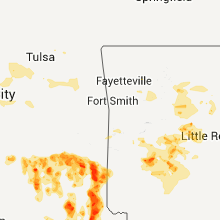
Hail Map for Tuesday, June 28, 2011

Number of Impacted Households on 6/28/2011
0
Impacted by 1" or Larger Hail
0
Impacted by 1.75" or Larger Hail
0
Impacted by 2.5" or Larger Hail
Square Miles of Populated Area Impacted on 6/28/2011
0
Impacted by 1" or Larger Hail
0
Impacted by 1.75" or Larger Hail
0
Impacted by 2.5" or Larger Hail


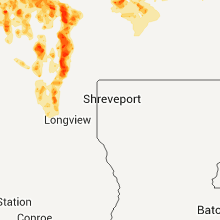


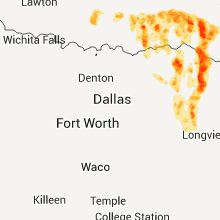
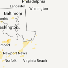


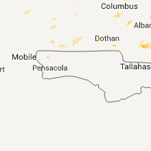


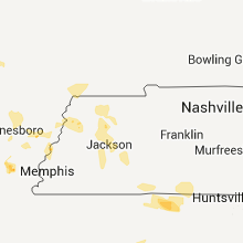
Cities Most Affected by Hail Storms of 6/28/2011
| Hail Size | Demographics of Zip Codes Affected | ||||||
|---|---|---|---|---|---|---|---|
| City | Count | Average | Largest | Pop Density | House Value | Income | Age |
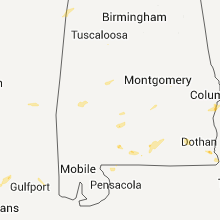
| Opp, AL | 2 | 1.75 | 1.75 | 59 | $56k | $27.2k | 43.0 |
| Nashoba, OK | 1 | 2.50 | 2.50 | 4 | $43k | $20.3k | 47.8 |
| Bethel, OK | 1 | 1.75 | 1.75 | 1 | $38k | $20.0k | 36.6 |
| Norman, AR | 1 | 1.75 | 1.75 | 7 | $39k | $26.8k | 47.2 |
| Avery, TX | 1 | 1.75 | 1.75 | 10 | $37k | $26.5k | 43.7 |
| Bluefield, VA | 1 | 1.75 | 1.75 | 190 | $74k | $29.4k | 42.8 |
| Idabel, OK | 1 | 1.75 | 1.75 | 58 | $48k | $22.9k | 37.9 |
| Antlers, OK | 1 | 1.75 | 1.75 | 24 | $45k | $21.8k | 42.4 |
| Rattan, OK | 1 | 1.75 | 1.75 | 3 | $38k | $26.4k | 42.7 |
| Blossom, TX | 1 | 1.75 | 1.75 | 35 | $44k | $31.6k | 40.8 |
Hail and Wind Damage Spotted on 6/28/2011
Filter by Report Type:Hail ReportsWind Reports
States Impacted
Arkansas, Alabama, Georgia, Missouri, Tennessee, Mississippi, South Carolina, West Virginia, Florida, Virginia, North Carolina, New York, Oklahoma, Texas, Colorado, Pennsylvania, Montana, Kansas, New Mexico, Wyoming, IdahoArkansas
| Local Time | Report Details |
|---|---|
| 12:08 PM UTC | Trees down on county road 318 and 333. power lines were down blocking 4 lanes of traffic at the 1800 block of east highland drive in jonesboro. a tree was also down on in craighead county AR, 58.7 miles NW of Memphis, TN |
| 12:10 PM UTC | Trees down on highway 364 in vanndal in cross county AR, 43 miles WNW of Memphis, TN |
| 12:15 PM UTC | Wind gust measured at asos site in walnut ridge in lawrence county AR, 81.6 miles NW of Memphis, TN |
| 12:22 PM UTC | Severe winds blew an 18 wheel tractor trailer off of highway 49 between marmaduke and halida in greene county AR, 73.2 miles NNW of Memphis, TN |
| 12:30 PM UTC | Power lines down on highland street in craighead county AR, 58.7 miles NW of Memphis, TN |
| 12:30 PM UTC | Trees down on county road 318 in craighead county AR, 58.7 miles NW of Memphis, TN |
| 12:56 PM UTC | Several large tree limbs were blown dow in prairie county AR, 46.3 miles ENE of Little Rock, AR |
| 12:57 PM UTC | Damage reported to the west elementary school in osceola as reported by the arkansas emergency management local coordinato in mississippi county AR, 38.1 miles N of Memphis, TN |
| 12:57 PM UTC | Widespread wind damage across the city of osceola with numerous trees...power poles...power lines...large street lights down and power outages over half the cit in mississippi county AR, 38.1 miles N of Memphis, TN |
| 1:39 PM UTC | Quarter sized hail reported near Perryville, AR, 34.9 miles WNW of Little Rock, AR |
| 3:23 PM UTC | Quarter sized hail reported near Jessieville, AR, 45.4 miles W of Little Rock, AR, hail fell for atleast five minutes. |
| 3:58 PM UTC | Ping Pong Ball sized hail reported near Mountain Pine, AR, 52.5 miles WSW of Little Rock, AR, hail fell for about ten minutes and is still currently falling. |
| 4:04 PM UTC | Quarter sized hail reported near Jessieville, AR, 45.4 miles W of Little Rock, AR, hail fell for atleast five minutes. |
| 4:04 PM UTC | Trees down on lakeshore drive inside of hot spring in garland county AR, 47.7 miles WSW of Little Rock, AR |
| 4:39 PM UTC | Golf Ball sized hail reported near Norman, AR, 36.6 miles NNE of Nashville, AR |
| 4:40 PM UTC | Half Dollar sized hail reported near Bismarck, AR, 52.7 miles ENE of Nashville, AR |
| 4:42 PM UTC | Quarter sized hail reported near Mt Ida, AR, 43.3 miles NNE of Nashville, AR |
| 4:51 PM UTC | Quarter sized hail reported near Caddo Gap, AR, 32.7 miles NNE of Nashville, AR |
| 5:30 PM UTC | Power lines and power poles are down across jessievill in garland county AR, 45.4 miles W of Little Rock, AR |
Alabama
| Local Time | Report Details |
|---|---|
| 12:10 PM UTC | A tree was knocked down north of the intersection of cr 47 and highway 64. time estimated by rada in lauderdale county AL, 18.7 miles NE of Florence, AL |
| 12:15 PM UTC | Tree down in dekalb county AL, 42.7 miles SW of Chattanooga, TN |
| 12:30 PM UTC | Large tree down. time estimated based on rada in marshall county AL, 66.6 miles SW of Chattanooga, TN |
| 12:30 PM UTC | Tree down on house in dekalb county AL, 50.8 miles SSW of Chattanooga, TN |
| 12:43 PM UTC | A tree was knocked down on helton drive near church road. time estimated by rada in lauderdale county AL, 5.5 miles N of Florence, AL |
| 12:43 PM UTC | A tree and power lines were knocked down across the road on the 100 block of cr 29 in killen. time estimated by rada in lauderdale county AL, 6.9 miles ENE of Florence, AL |
| 12:43 PM UTC | A tree was knocked down on cr107 near the bridge in center star. time estimated by rada in lauderdale county AL, 13.3 miles ENE of Florence, AL |
| 12:43 PM UTC | A tree was knocked down on power lines at the 600 block of cr 107 in center star. time estimated by rada in lauderdale county AL, 13.3 miles ENE of Florence, AL |
| 12:55 PM UTC | A tree was knocked down on cr 31 about 4 miles south of u.s. highway 72. time estimated by rada in lauderdale county AL, 13.7 miles ENE of Florence, AL |
| 1:18 PM UTC | A tree was knocked down on veterans drive near the patton island bridge. time estimated by rada in lauderdale county AL, 0.8 miles SSE of Florence, AL |
| 1:23 PM UTC | Power lines were knocked down on old memphis road in tuscumbia. time estimated by radar and other report in colbert county AL, 6.4 miles SSW of Florence, AL |
| 1:23 PM UTC | Power lines were knocked down on cave street in tuscumbia. time estimated by radar and other report in colbert county AL, 5.1 miles SSW of Florence, AL |
| 1:23 PM UTC | Power lines were knocked down into a tree on lamar street in tuscumbia. time estimated by radar and other report in colbert county AL, 5.5 miles SSW of Florence, AL |
| 1:25 PM UTC | Trees down on car and power lines down in colbert county AL, 3.1 miles SSW of Florence, AL |
| 1:25 PM UTC | Power lines down in colbert county AL, 4 miles SSW of Florence, AL |
| 1:25 PM UTC | Quarter sized hail reported near Muscle Shoals, AL, 4.2 miles S of Florence, AL |
| 1:30 PM UTC | Tree down and power lines dow in colbert county AL, 4.9 miles S of Florence, AL |
| 2:00 PM UTC | Large tree limb down on hous in madison county AL, 59.7 miles E of Florence, AL |
| 5:07 PM UTC | Tree on a trailer. two people trapped...no injurie in lamar county AL, 39.7 miles ENE of Starkville, MS |
| 5:46 PM UTC | Tree down blocking cr 12 in pickens county AL, 43.6 miles ESE of Starkville, MS |
| 5:55 PM UTC | Multiple trees down on cr 57 in pickens county AL, 53.7 miles E of Starkville, MS |
| 6:16 PM UTC | Tree down on cr 191 in greene county AL, 61.7 miles ESE of Starkville, MS |
| 8:54 PM UTC | Emergency manager reported that two storage buildings were flipped over and a business received roof damage in highland hom in crenshaw county AL, 57.7 miles E of Camden, AL |
| 8:54 PM UTC | Golf Ball sized hail reported near Opp, AL, 64.7 miles N of Miramar Beach, FL, report of golf ball size hail from the union grove fire department. |
| 9:05 PM UTC | Downed trees and power lines in southwest ozark in dale county AL, 80.4 miles S of Auburn, AL |
| 9:46 PM UTC | Golf Ball sized hail reported near Opp, AL, 64.7 miles N of Miramar Beach, FL, report of golf ball size hail from the union grove fire department. |
| 9:55 PM UTC | Multiple power poles reported down by law enforcement dispatc in houston county AL, 72.5 miles NW of Tallahassee, FL |
Georgia
| Local Time | Report Details |
|---|---|
| 12:30 PM UTC | Chattooga county emergency management reports a tree down on hemphill roa in chattooga county GA, 33.2 miles S of Chattanooga, TN |
| 12:40 PM UTC | Chattooga county emergency management reports a downed tree on goodwin drive at wylan hill in chattooga county GA, 37.7 miles S of Chattanooga, TN |
| 12:50 PM UTC | Chattooga county emergency management reports a downed tree on goodwin drive at wylan hill in chattooga county GA, 37.7 miles S of Chattanooga, TN |
| 1:16 PM UTC | Chattooga county emergency management reports a tree down on hemphill roa in chattooga county GA, 33.2 miles S of Chattanooga, TN |
| 6:45 PM UTC | Half of a chicken house roof torn off by thunderstorm winds off of copper lake road. time estimated based on rada in bacon county GA, 18.6 miles ENE of Douglas, GA |
| 7:05 PM UTC | Retired nws employee reports a few downed oak limbs and sporadic wind gusts around 50 mph in centervill in houston county GA, 87.1 miles SSE of Atlanta, GA |
| 8:55 PM UTC | 3 trees down along highway 280 eas in evans county GA, 47.8 miles W of Savannah, GA |
| 9:10 PM UTC | 1 tree down at drayton roa in crisp county GA, 63.1 miles WNW of Douglas, GA |
| 9:15 PM UTC | An awning was blown off a building downtown. a tree was also reported dow in seminole county GA, 54.6 miles NW of Tallahassee, FL |
| 9:50 PM UTC | 911 operator reports several trees dow in tift county GA, 32.5 miles W of Douglas, GA |
| 9:51 PM UTC | A trampoline was blown across the street and a pecan tree blow ove in mitchell county GA, 54.6 miles N of Tallahassee, FL |
| 10:05 PM UTC | Multiple trees and powerlines reported down in the city of nashvill in berrien county GA, 31.7 miles SW of Douglas, GA |
| 10:15 PM UTC | 1 tree dow in laurens county GA, 58.9 miles N of Douglas, GA |
| 10:30 PM UTC | Law enforcement dispatch reports multiple trees and powerlines down in moultrie. power is reported out over the entire southwestern portion of moultri in colquitt county GA, 58.7 miles NNE of Tallahassee, FL |
Missouri
| Local Time | Report Details |
|---|---|
| 12:40 PM UTC | Public observer reports thunderstorm winds to at least 60 mph with several large branches knocked down. additional strong winds continue behind the thunderstorm lin in dunklin county MO, 67.9 miles N of Memphis, TN |
Tennessee
| Local Time | Report Details |
|---|---|
| 1:15 PM UTC | Trees reported down along the 8800 block of shakerag road in memphis/millingto in shelby county TN, 15.3 miles NE of Memphis, TN |
| 1:17 PM UTC | Memphis light gas and water reports broken tree limbs on power lines in the frayser area up toward millington. about 65 outages reported across shelby county...affectin in shelby county TN, 6.6 miles NE of Memphis, TN |
| 1:23 PM UTC | Tree down on house on mclean blvd. report from wreg. time estimate in shelby county TN, 4.1 miles ESE of Memphis, TN |
| 1:30 PM UTC | A large tree branch was downed along n. germantown road to the north of club parkwa in shelby county TN, 15.2 miles E of Memphis, TN |
| 1:40 PM UTC | Trees and power lines down across tipton count in tipton county TN, 36.7 miles NE of Memphis, TN |
| 1:50 PM UTC | A tree at least 3 feet in diameter was down on 2 houses and a ca in shelby county TN, 6.3 miles ESE of Memphis, TN |
| 2:57 PM UTC | A tree was down on highway 200 in the western part of henderson count in henderson county TN, 36.9 miles S of Mc Kenzie, TN |
| 3:39 PM UTC | A tree was down on bible hill roa in decatur county TN, 36.8 miles SE of Mc Kenzie, TN |
| 3:40 PM UTC | A tree was blown down in camde in benton county TN, 24 miles ESE of Mc Kenzie, TN |
Mississippi
| Local Time | Report Details |
|---|---|
| 1:44 PM UTC | Damage sustained to a firestation in the town of barton in extreme northwest marshall count in marshall county MS, 24.6 miles SE of Memphis, TN |
| 2:00 PM UTC | Trees down scattered across the north end of the count in marshall county MS, 34.5 miles SE of Memphis, TN |
| 3:05 PM UTC | Trained spotter reported through ham radio operator reports moderate building damage including damage to barns and sheds. numerous trees have also been downe in prentiss county MS, 56.4 miles W of Florence, AL |
| 3:10 PM UTC | Trees down on county road 8031 1/2 mile north of hwy 4 in prentiss county MS, 55.8 miles W of Florence, AL |
| 3:15 PM UTC | Trees down along county road 806 in prentiss county MS, 52.3 miles W of Florence, AL |
| 3:23 PM UTC | Storm damage reported in alcorn county MS, 48.9 miles WNW of Florence, AL |
| 3:48 PM UTC | Large tree down on hwy 72 in tishomingo county MS, 29.8 miles W of Florence, AL |
| 3:58 PM UTC | Large tree down hwy 25 in tishomingo county MS, 35.7 miles WSW of Florence, AL |
| 5:00 PM UTC | A couple trees dow in lowndes county MS, 33.6 miles ENE of Starkville, MS |
| 10:33 PM UTC | Several trees were knocked down along highway 1 in pearl river county MS, 55.8 miles NNE of New Orleans, LA |
South Carolina
| Local Time | Report Details |
|---|---|
| 5:35 PM UTC | Spotter reported large oak tree down in back yar in berkeley county SC, 12.2 miles NW of Charleston, SC |
| 7:02 PM UTC | Trees reported down in williston along with dime to quarter size hail. time estimated by rada in barnwell county SC, 33.1 miles E of Augusta, GA |
| 7:15 PM UTC | Quarter sized hail reported near Islandton, SC, 57.3 miles WSW of Charleston, SC |
| 7:26 PM UTC | Trees down along brewington rd near hwy 378 in sumter county SC, 48.9 miles NNW of Charleston, SC |
| 7:43 PM UTC | Highway patrol reported trees down along interstate 95 at mile marker 14 in sumter county SC, 55.4 miles N of Charleston, SC |
| 7:44 PM UTC | Trees down at hwy 64 and mulberry rd. time estimated by radar in barnwell county SC, 45.4 miles ESE of Augusta, GA |
| 7:47 PM UTC | Quarter sized hail reported near McBee, SC, 60.5 miles SSE of Charlotte, NC, mcleod farms reported hail the size of pecans |
| 7:52 PM UTC | Tree down on mccutcheon roa in florence county SC, 48.7 miles NNE of Charleston, SC |
| 7:56 PM UTC | Trees down on union church rd. time estimated by rada in chesterfield county SC, 62 miles SSE of Charlotte, NC |
| 8:10 PM UTC | Large branches down on 2280 vox hw in florence county SC, 50 miles NNE of Charleston, SC |
| 8:13 PM UTC | Sheriff dispatch reported trees down near the pisgah communit in kershaw county SC, 55.7 miles SSE of Charlotte, NC |
| 8:21 PM UTC | Tree down across sandpit road just south of us37 in florence county SC, 55 miles NNE of Charleston, SC |
| 9:06 PM UTC | Trees down at intersection of hwy 97 and hwy 200 in lancaster county SC, 43 miles S of Charlotte, NC |
| 9:08 PM UTC | Sheriff dispatch reported trees down in the liberty hill are in kershaw county SC, 51.2 miles S of Charlotte, NC |
West Virginia
| Local Time | Report Details |
|---|---|
| 6:11 PM UTC | Quarter sized hail reported near Matoaka, WV, 62.6 miles SSE of Charleston, WV, marble to quarter size hail for 15 minutes |
Florida
| Local Time | Report Details |
|---|---|
| 6:30 PM UTC | Several powerlines down...one on vehicle. several rvs overturned. one tree on residence. reported along s.r. 90 in de funiak spring in walton county FL, 27.8 miles NNE of Miramar Beach, FL |
Virginia
| Local Time | Report Details |
|---|---|
| 6:48 PM UTC | Golf Ball sized hail reported near Bluefield, VA, 68.4 miles NE of Bristol, TN |
| 7:15 PM UTC | Quarter sized hail reported near Dendron, VA, 50.5 miles ESE of Richmond, VA |
| 7:24 PM UTC | Trees down on adria r in tazewell county VA, 54.4 miles NE of Bristol, TN |
| 7:30 PM UTC | Tree down in giles county VA, 43.7 miles W of Roanoke, VA |
| 8:00 PM UTC | Trees down along colonial parkway and rte 238 in york county VA, 41.8 miles NW of Virginia Beach, VA |
| 8:01 PM UTC | Tree knocked down onto red hill roa in albemarle county VA, 58.6 miles WNW of Richmond, VA |
| 8:12 PM UTC | Tree knocked down onto power lines along scottsville roa in albemarle county VA, 56.3 miles WNW of Richmond, VA |
| 8:20 PM UTC | Two trees down and in the road. north side of town on 36 in halifax county VA, 65.7 miles ESE of Roanoke, VA |
| 8:25 PM UTC | Large branches down newport road. report via wdbj in roanoke county VA, 12.4 miles NW of Roanoke, VA |
| 8:25 PM UTC | Large branches down newport road. report via wdbj in craig county VA, 13.7 miles NW of Roanoke, VA |
| 8:25 PM UTC | Trees down on blackberry road near sanvill in henry county VA, 36.9 miles S of Roanoke, VA |
| 8:30 PM UTC | Tree down in henry county VA, 36.2 miles S of Roanoke, VA |
| 8:31 PM UTC | Quarter sized hail reported near Earlysville, VA, 66.2 miles NW of Richmond, VA |
| 8:35 PM UTC | Two trees down in charlotte county VA, 70.8 miles SW of Richmond, VA |
| 8:36 PM UTC | Tree down in amherst county VA, 54.2 miles ENE of Roanoke, VA |
| 8:45 PM UTC | Many trees down in city. also 12 inches water closed roads in cit in city of buena vist county VA, 44.5 miles NE of Roanoke, VA |
| 8:47 PM UTC | Tree down in henry county VA, 40.1 miles S of Roanoke, VA |
| 8:51 PM UTC | Storm damage reported in roanoke county VA, 4.6 miles NNW of Roanoke, VA |
| 8:54 PM UTC | Storm damage reported in roanoke county VA, 4.6 miles NNW of Roanoke, VA |
| 8:54 PM UTC | Trees and limbs blown down across the street in culpeper county VA, 82.2 miles WSW of Baltimore, MD |
| 8:54 PM UTC | Limbs blown down in culpeper county VA, 82.5 miles N of Richmond, VA |
| 8:54 PM UTC | Quarter sized hail reported near Amissville, VA, 82.5 miles N of Richmond, VA |
| 9:00 PM UTC | Many trees dow in botetourt county VA, 10.1 miles NNE of Roanoke, VA |
| 9:12 PM UTC | Tree and power line down in franklin county VA, 14.3 miles SSE of Roanoke, VA |
| 9:35 PM UTC | Tree down in franklin county VA, 21.8 miles SSE of Roanoke, VA |
| 9:48 PM UTC | Two trees down across power line in bedford county VA, 36.3 miles E of Roanoke, VA |
| 9:48 PM UTC | Tree down in bedford county VA, 37.4 miles ENE of Roanoke, VA |
| 9:53 PM UTC | Tree down on ensors shop rd in fauquier county VA, 70.1 miles N of Richmond, VA |
| 10:00 PM UTC | Trees down citywid in city of lynchburg county VA, 45.2 miles ENE of Roanoke, VA |
| 10:00 PM UTC | Trees down on lynchburg college campu in city of lynchburg county VA, 42.8 miles ENE of Roanoke, VA |
| 10:01 PM UTC | One tree down along leesville roa in campbell county VA, 39.2 miles E of Roanoke, VA |
| 10:03 PM UTC | Trees down on power line in campbell county VA, 46.3 miles E of Roanoke, VA |
| 10:05 PM UTC | 12 or more large trees down in franklin county VA, 12.5 miles S of Roanoke, VA |
| 10:07 PM UTC | Tree down in campbell county VA, 48 miles E of Roanoke, VA |
| 10:10 PM UTC | Two trees dow in campbell county VA, 48 miles E of Roanoke, VA |
| 10:13 PM UTC | Quarter sized hail reported near Amelia Court House, VA, 24.3 miles WSW of Richmond, VA, near the intersection of clement town road and genito road. |
| 10:15 PM UTC | Tree down on enders shop rd in fauquier county VA, 73.8 miles N of Richmond, VA |
| 10:15 PM UTC | Trees down on rt 20 at allensleve in buckingham county VA, 46.2 miles W of Richmond, VA |
| 10:18 PM UTC | Numerous trees down across the area especially north of nottowa in nottoway county VA, 31.7 miles SW of Richmond, VA |
| 10:30 PM UTC | Many trees dow in campbell county VA, 46.3 miles E of Roanoke, VA |
| 10:31 PM UTC | 2 trees down at the intersect of bellevue rd/myers rd in halifax county VA, 67.2 miles NNW of Raleigh, NC |
| 10:33 PM UTC | Extensive tree damage county wide in stafford county VA, 64.7 miles NNE of Richmond, VA |
| 10:34 PM UTC | Large tree down on power line in henrico county VA, 16.3 miles ENE of Richmond, VA |
| 10:35 PM UTC | Two trees down in halifax county VA, 67.1 miles NNW of Raleigh, NC |
| 6:35 PM EDT | Quarter sized hail reported near Blackstone, VA, 24.7 miles SW of Richmond, VA, quarter hail and trees blocking road along powhatan/amelia county line |
| 10:42 PM UTC | Tree down in pittsylvania county VA, 53.2 miles SE of Roanoke, VA |
| 10:45 PM UTC | Trees down on rt 61 in charlotte county VA, 68.7 miles SW of Richmond, VA |
| 10:57 PM UTC | Several large limbs down in accomack county VA, 34.5 miles SW of Ocean City, MD |
| 11:00 PM UTC | Trees down countywid in campbell county VA, 46.3 miles E of Roanoke, VA |
| 11:00 PM UTC | Numerous trees down along a 2-3 mile stretch of beach roa in chesterfield county VA, 10 miles S of Richmond, VA |
| 11:01 PM UTC | Trees on power lines in the 1000 block of mountain rd in halifax county VA, 65.2 miles ESE of Roanoke, VA |
| 11:05 PM UTC | Large tree downed onto a deck at residence in midlothian harbor point village in chesterfield county VA, 6.5 miles S of Richmond, VA |
| 11:10 PM UTC | Trees down in prince edward county VA, 44 miles WSW of Richmond, VA |
| 11:10 PM UTC | Trees down just north of the twin lakes are in prince edward county VA, 40.3 miles WSW of Richmond, VA |
| 11:12 PM UTC | Trees down in pocahontas state park between swift creek and courthouse roa in chesterfield county VA, 9.3 miles SSE of Richmond, VA |
| 11:13 PM UTC | Several trees down in staunton river state park in halifax county VA, 63.1 miles N of Raleigh, NC |
| 11:20 PM UTC | Two trees down and in the road. north side of town on 36 in halifax county VA, 65.7 miles ESE of Roanoke, VA |
| 11:25 PM UTC | Piece of patio furniture blown through window of residence on poplar view road in cheste in chesterfield county VA, 17.6 miles SE of Richmond, VA |
| 11:25 PM UTC | Trees down along route 724 southwest of crew in nottoway county VA, 38.4 miles SW of Richmond, VA |
| 11:30 PM UTC | Trees down at hollywoo in appomattox county VA, 60.4 miles W of Richmond, VA |
| 12:10 AM UTC | Numerous trees and power poles down just south of alberta near interstate 85 and highway in brunswick county VA, 47 miles SSW of Richmond, VA |
| 12:12 AM UTC | Quarter sized hail reported near Yorktown, VA, 43.8 miles NW of Virginia Beach, VA |
| 12:15 AM UTC | Trees down on rt. 360 in essex county VA, 52.4 miles NE of Richmond, VA |
| 12:25 AM UTC | Trees dow in dinwiddie county VA, 30.2 miles S of Richmond, VA |
| 12:25 AM UTC | Numerous trees down near intersection of vaughn rd and flank r in dinwiddie county VA, 26 miles SSE of Richmond, VA |
| 12:25 AM UTC | Numerous trees dow in dinwiddie county VA, 29.4 miles SSE of Richmond, VA |
| 12:25 AM UTC | Large limbs dow in dinwiddie county VA, 31.5 miles SSE of Richmond, VA |
| 12:28 AM UTC | Tree dow in city of petersburg county VA, 26 miles SSE of Richmond, VA |
| 12:40 AM UTC | Trees down along south crater road north of carso in prince george county VA, 35.1 miles SSE of Richmond, VA |
| 12:43 AM UTC | Time is radar estimated...tree down in sussex county VA, 40.6 miles SSE of Richmond, VA |
| 2:12 AM UTC | Large limb down in yard in accomack county VA, 45.4 miles SW of Ocean City, MD |
North Carolina
| Local Time | Report Details |
|---|---|
| 7:22 PM UTC | Multiple trees down near marthas chapel road and farrington rd in chatham county NC, 20.6 miles W of Raleigh, NC |
| 7:51 PM UTC | Three 8-10 inch diameter trees down partially blocking okelly chapel rd in chatham county NC, 15.5 miles WNW of Raleigh, NC |
| 8:23 PM UTC | Skywarn spotter reports 7-10 large trees one foot in diameter blown down near old us 1 and issac st. some fences at horse and buddy were also damaged. time estimate in wake county NC, 20.3 miles WSW of Raleigh, NC |
| 8:23 PM UTC | Skywarn spotter reports 7-10 large trees one foot in diameter blown down near old us 1 and issac st. time estimate in wake county NC, 20.3 miles WSW of Raleigh, NC |
| 8:30 PM UTC | Quarter sized hail reported near Boone, NC, 40.5 miles SE of Bristol, TN |
| 8:36 PM UTC | Multiple trees down in chatham county NC, 25 miles SW of Raleigh, NC |
| 8:56 PM UTC | Multiple trees reported down near knottwood d in lee county NC, 41.6 miles SW of Raleigh, NC |
| 9:06 PM UTC | 2 trees down near the intersection of us 1 and us 15-501. time estimate in lee county NC, 38.2 miles SW of Raleigh, NC |
| 9:15 PM UTC | Tree down in wilkes county NC, 54.8 miles ESE of Bristol, TN |
| 9:44 PM UTC | Multiple trees and power lines down just east of littleton... dime sized hail also observed in halifax county NC, 61.6 miles NE of Raleigh, NC |
| 9:45 PM UTC | Multiple trees down near hwy 16 at max burgess mobile home par in alexander county NC, 53.7 miles NNW of Charlotte, NC |
| 9:45 PM UTC | One tree down on piney grove roa in alexander county NC, 53.5 miles NNW of Charlotte, NC |
| 9:50 PM UTC | Trees and power lines down across town. one tree fell on a ca in robeson county NC, 73.8 miles SSW of Raleigh, NC |
| 9:53 PM UTC | Tree and power lines dow in halifax county NC, 61.2 miles NE of Raleigh, NC |
| 9:55 PM UTC | *** 2 inj *** thunderstorm winds blew over a tent on lafayette street in salisbury...causing minor injuries to 2 peopl in rowan county NC, 36.9 miles NNE of Charlotte, NC |
| 9:55 PM UTC | One large tree down on knox stree and a few large limbs down on crawford stree in rowan county NC, 36.9 miles NNE of Charlotte, NC |
| 9:55 PM UTC | Trees down and blocking traffic near the intersection of randolph road and colville roa in mecklenburg county NC, 3.3 miles SSE of Charlotte, NC |
| 9:55 PM UTC | Trees down on monroe road and blocking traffic...between dunn avenue and briar cree in mecklenburg county NC, 4.2 miles SSE of Charlotte, NC |
| 9:57 PM UTC | 5 trees down at a residence on powell farm rd near anderson cree in harnett county NC, 36.8 miles SSW of Raleigh, NC |
| 10:00 PM UTC | Tree down on lemuel black rd near anderson creek schoo in harnett county NC, 37.6 miles SSW of Raleigh, NC |
| 10:00 PM UTC | Several trees down across the southern portions of the county in harnett county NC, 40.5 miles SSW of Raleigh, NC |
| 10:00 PM UTC | Tree down on nursery rd near west harnett schoo in harnett county NC, 36.1 miles SSW of Raleigh, NC |
| 10:00 PM UTC | Ping Pong Ball sized hail reported near Hickory, NC, 45.8 miles NW of Charlotte, NC, on hw-127 in the viewmont community. |
| 10:05 PM UTC | One tree down on the shoulder on the inner loop of i-485...1/2 to 3/4 of a mile east of the johnston road exi in mecklenburg county NC, 10.9 miles SSE of Charlotte, NC |
| 10:07 PM UTC | Power lines down on bingham dr north of fisher rd. time estimate in cumberland county NC, 56.8 miles SSW of Raleigh, NC |
| 10:10 PM UTC | Trees dow in rockingham county NC, 64.4 miles SSE of Roanoke, VA |
| 10:12 PM UTC | One tree down near the intersection of sulpher springs road and springs road. also penny to nickel sized hai in catawba county NC, 44.4 miles NNW of Charlotte, NC |
| 10:13 PM UTC | Tree down on mclamb rd near hwy 27 eas in harnett county NC, 26.1 miles S of Raleigh, NC |
| 10:15 PM UTC | Tree down on nc82 near averasboro battlefield museum in harnett county NC, 35.6 miles S of Raleigh, NC |
| 10:22 PM UTC | Tree down in wilkes county NC, 72 miles ESE of Bristol, TN |
| 10:22 PM UTC | Tree down in wilkes county NC, 72.4 miles ESE of Bristol, TN |
| 10:30 PM UTC | Multiple trees reported down on father springs road north of newton near the conover are in catawba county NC, 39.9 miles NNW of Charlotte, NC |
| 10:33 PM UTC | One tree down at highway 50 and elevation road... town of four oaks without power in johnston county NC, 23.6 miles SSE of Raleigh, NC |
| 10:35 PM UTC | Large limb blocking the southbound lane of easy street near highway 55 amd maple goat church road in sampson county NC, 39.1 miles SSE of Raleigh, NC |
| 10:40 PM UTC | 2 trees down near the 2800 block of w memorial highwa in iredell county NC, 55 miles N of Charlotte, NC |
| 10:50 PM UTC | A large tree limb brought down powerlines on fort dobbs road...just off hw-2 in iredell county NC, 41.2 miles N of Charlotte, NC |
| 10:50 PM UTC | Tree down and blocking the roadway at 939 turnersburg highwa in iredell county NC, 42.6 miles N of Charlotte, NC |
| 10:54 PM UTC | One tree down on mossy meadow drive in high point... pea size hail also observed in guilford county NC, 72.6 miles NE of Charlotte, NC |
| 10:57 PM UTC | Trees down. time estimate in guilford county NC, 73.8 miles NE of Charlotte, NC |
| 11:00 PM UTC | Trees down on rt 6 in yadkin county NC, 71.2 miles NNE of Charlotte, NC |
| 11:00 PM UTC | Trees down on hwy 26 in surry county NC, 70.8 miles N of Charlotte, NC |
| 11:01 PM UTC | Scattered trees down across guilford count in guilford county NC, 70.3 miles WNW of Raleigh, NC |
| 11:05 PM UTC | Powerlines down at 299 old mountain roa in iredell county NC, 35.3 miles N of Charlotte, NC |
| 11:05 PM UTC | Trees down. time estimate in guilford county NC, 71.4 miles WNW of Raleigh, NC |
| 11:10 PM UTC | One tree down on a house at 118 pine haven road...and the roof is collapse in iredell county NC, 35.1 miles N of Charlotte, NC |
| 11:15 PM UTC | Tree blocking the roadway at the 600 block of shiloh roa in iredell county NC, 36.4 miles N of Charlotte, NC |
| 11:20 PM UTC | One tree down and blocking the ramp of interstate 40 at main street in forsyth county NC, 67.1 miles NNE of Charlotte, NC |
| 11:32 PM UTC | Multiple trees and power lines down at highway 150 and fishel road in forsyth county NC, 63 miles NNE of Charlotte, NC |
| 11:40 PM UTC | Multiple trees down on potneck rd at hwy 80 in rowan county NC, 40.2 miles NNE of Charlotte, NC |
| 11:40 PM UTC | Report of tree down on sparrow-dairy road. time estimated from rada in gaston county NC, 19.2 miles W of Charlotte, NC |
New York
| Local Time | Report Details |
|---|---|
| 8:30 PM UTC | 12-14 foot boats moved about 100 feet... 20 foot boat tipped over... large tree down in yates county NY, 56.7 miles WSW of Syracuse, NY |
| 8:42 PM UTC | 12-14 foot boats moved about 100 feet... 20 foot boat tipped over... large tree down in yates county NY, 56.7 miles WSW of Syracuse, NY |
| 8:45 PM UTC | Trees and wires dow in yates county NY, 50.6 miles WSW of Syracuse, NY |
| 8:45 PM UTC | Numerous trees down at long point...near the shore of seneca lak in yates county NY, 50.1 miles WSW of Syracuse, NY |
| 8:58 PM UTC | Trees and wires down in madison county NY, 14 miles E of Syracuse, NY |
| 8:58 PM UTC | Trees down in madison county NY, 14 miles E of Syracuse, NY |
| 9:20 PM UTC | Trees and wires dow in cayuga county NY, 27.2 miles SSW of Syracuse, NY |
| 9:25 PM UTC | Numerous trees dow in cayuga county NY, 23.8 miles SSW of Syracuse, NY |
| 9:50 PM UTC | Numerous poles and primary wires down in cortland county NY, 23.5 miles SSE of Syracuse, NY |
| 10:32 PM UTC | Numerous trees down in and around the town in tompkins county NY, 39.4 miles SSW of Syracuse, NY |
| 10:53 PM UTC | Trees down on route 11 in broome county NY, 48.9 miles S of Syracuse, NY |
| 10:53 PM UTC | Trees down on route 26 in broome county NY, 50.5 miles S of Syracuse, NY |
| 11:00 PM UTC | One tree down partially blocking road on county route 1 in hamilton county NY, 51.2 miles NNW of Schenectady, NY |
| 11:15 PM UTC | Storm damage reported in madison county NY, 24.8 miles E of Syracuse, NY |
| 11:34 PM UTC | Several trees down on race rd...county rt 3a and route 12 in chenango county NY, 51.5 miles SSE of Syracuse, NY |
| 11:40 PM UTC | One tree down on garnet lake roa in warren county NY, 49.7 miles N of Schenectady, NY |
| 11:45 PM UTC | One tree dow in warren county NY, 42.6 miles N of Schenectady, NY |
| 11:50 PM UTC | Telephone wires down in chenango county NY, 61.9 miles SSE of Syracuse, NY |
| 12:13 AM UTC | Several trees and some wires dow in delaware county NY, 59.9 miles NNE of Scranton, PA |
| 12:39 AM UTC | Telephone wires down in chenango county NY, 61.9 miles SSE of Syracuse, NY |
| 3:19 AM UTC | Trees and wires dow in dutchess county NY, 56.1 miles S of Schenectady, NY |
| 3:23 AM UTC | Multiple reports of trees and wires including 131 montgomery st...6511 springbrook ave...and route 9 which is closed due to multiple trees dow in dutchess county NY, 60.9 miles S of Schenectady, NY |
Oklahoma
| Local Time | Report Details |
|---|---|
| 9:00 PM UTC | Golf Ball sized hail reported near Bethel, OK, 68.1 miles WNW of Nashville, AR, golf ball size hail just east of battiest. |
| 9:41 PM UTC | Golf Ball sized hail reported near Rattan, OK, 60.5 miles E of Atoka, OK, hail of long duration. mostly nickel to dime with larger up to golf ball mixed in. |
| 9:45 PM UTC | Quarter sized hail reported near Watson, OK, 50.3 miles WNW of Nashville, AR, quarter size hail fell in the hochatown community. |
| 9:45 PM UTC | Tennis Ball sized hail reported near Nashoba, OK, 52.8 miles E of Atoka, OK, severely damaged body of car. broke out windshield. |
| 10:00 PM UTC | Several trees down in broken bo in mccurtain county OK, 51.6 miles W of Nashville, AR |
| 10:00 PM UTC | Quarter sized hail reported near Broken Bow, OK, 52.2 miles W of Nashville, AR, quarter size hail fell just west of broken bow. |
| 10:06 PM UTC | Power lines downed in the holly creek communit in mccurtain county OK, 55.9 miles W of Nashville, AR |
| 10:15 PM UTC | Storm damage reported in mccurtain county OK, 55.9 miles W of Nashville, AR |
| 10:29 PM UTC | Golf Ball sized hail reported near Idabel, OK, 56 miles W of Nashville, AR, golf ball size hail falling in idabel. |
| 10:40 PM UTC | Measured at the idabel oklahoma mesonet statio in mccurtain county OK, 59.8 miles W of Nashville, AR |
| 11:30 PM UTC | Ping Pong Ball sized hail reported near Daisy, OK, 24.3 miles ENE of Atoka, OK |
| 11:35 PM UTC | Golf Ball sized hail reported near Antlers, OK, 31 miles ESE of Atoka, OK |
| 12:00 AM UTC | Half Dollar sized hail reported near Atoka, OK, 17.1 miles ESE of Atoka, OK |
| 12:10 AM UTC | Quarter sized hail reported near Tushka, OK, 5.1 miles SSW of Atoka, OK |
| 12:37 AM UTC | One-inch hail also covering ground in atoka county OK, 4.8 miles SSE of Atoka, OK |
| 1:09 AM UTC | Quarter sized hail reported near Coalgate, OK, 14 miles WNW of Atoka, OK |
| 1:15 AM UTC | Half Dollar sized hail reported near Bennington, OK, 21.8 miles S of Atoka, OK |
| 2:45 AM UTC | Storm damage reported in texas county OK, 79 miles SSW of Garden City, KS |
| 3:19 AM UTC | Storm damage reported in beaver county OK, 70.3 miles S of Garden City, KS |
| 3:55 AM UTC | Storm damage reported in beaver county OK, 67.8 miles WNW of Woodward, OK |
| 3:58 AM UTC | Power poles down for several miles west of elmwood along highway 412 in beaver county OK, 63.7 miles WNW of Woodward, OK |
| 3:58 AM UTC | 11-12 power poles down for at least 8 miles along highway 412. power poles were snapped off about 6 to 8 feet u in beaver county OK, 70.8 miles W of Woodward, OK |
| 3:58 AM UTC | Power poles down for at least 8 miles along highway 41 in beaver county OK, 70.8 miles W of Woodward, OK |
| 4:10 AM UTC | Storm damage reported in beaver county OK, 49.3 miles WNW of Woodward, OK |
| 4:15 AM UTC | South side of a perimeter wood fence blown down...also heavy lawn furniture was blown across the yard. delayed report from tuesday night in beaver county OK, 59.6 miles WNW of Woodward, OK |
| 5:08 AM UTC | Storm damage reported in ellis county OK, 21.6 miles WSW of Woodward, OK |
| 5:15 AM UTC | Storm damage reported in woodward county OK, 4.5 miles W of Woodward, OK |
Texas
| Local Time | Report Details |
|---|---|
| 10:40 PM UTC | Trees down across highway 37 near silver city and the red river bordering mccurtain county in red river county TX, 69.5 miles W of Nashville, AR |
| 6:00 PM CDT | Trees down across fm 114 between the english community and the bowie county lin in red river county TX, 61.2 miles WSW of Nashville, AR |
| 11:15 PM UTC | Golf Ball sized hail reported near Avery, TX, 60.3 miles WSW of Nashville, AR |
| 6:25 PM CDT | Trees and power lines down in boxelder in red river county TX, 68 miles WSW of Nashville, AR |
| 6:50 PM CDT | Estimated 60-70 mph wind gust in lamar county TX, 65.4 miles SE of Atoka, OK |
| 11:50 PM UTC | Quarter sized hail reported near Blossom, TX, 65.4 miles SE of Atoka, OK |
| 12:05 AM UTC | Golf Ball sized hail reported near Blossom, TX, 65.4 miles SE of Atoka, OK, the public reported that it hailed on and off for nearly 30 minutes in blossom with the largest hail stones the size of golfballs. |
| 12:10 AM UTC | Numerous trees and power lines down across much of titus county. roofs were blown off of several homes. trees down on at least 5 homes in the count in titus county TX, 84.5 miles SW of Nashville, AR |
| 7:15 PM CDT | Half Dollar sized hail reported near Bogata, TX, 76.3 miles SE of Atoka, OK, half dollar size hail falling south of detroit or about 3 nne of deport just inside western red river county. |
| 12:16 AM UTC | Quarter sized hail reported near Mt Pleasant, TX, 78.4 miles SW of Nashville, AR, quarter size hail fell at a convenience store in cookville. |
| 12:16 AM UTC | Trees down adjacent to a convenience store in cookvill in titus county TX, 78.4 miles SW of Nashville, AR |
| 7:45 PM CDT | Storm damage reported in hopkins county TX, 79.6 miles ENE of Dallas, TX |
| 12:45 AM UTC | Power lines down in pittsbur in camp county TX, 78.7 miles WNW of Shreveport, LA |
| 12:45 AM UTC | The roof of a local hotel was almost entirely ripped of in camp county TX, 78.7 miles WNW of Shreveport, LA |
| 12:45 AM UTC | Trees down near broach and elm street. a fence was blown down as wel in camp county TX, 78.7 miles WNW of Shreveport, LA |
| 7:50 PM CDT | Storm damage reported in hopkins county TX, 84.1 miles ENE of Dallas, TX |
| 12:50 AM UTC | Numerous trees down throughout northern wood county...especially in the yantis and winnsboro communitie in wood county TX, 88.4 miles E of Dallas, TX |
| 8:00 PM CDT | Numerous trees and power lines across franklin count in franklin county TX, 95.4 miles ENE of Dallas, TX |
| 1:15 AM UTC | A pine tree fell crushing a vehicle and part of his home on wood county road 213 in wood county TX, 77.7 miles E of Dallas, TX |
| 1:15 AM UTC | A roof was blown off a home on cr 214 in wood county TX, 77.7 miles E of Dallas, TX |
| 1:20 AM UTC | Numerous trees have been blown down across western and northwest upshur count in upshur county TX, 80.1 miles WNW of Shreveport, LA |
| 1:20 AM UTC | A roof was blown off a home on hwy 37 between quitman and mineol in wood county TX, 78.9 miles E of Dallas, TX |
| 1:25 AM UTC | Trees blown down in hainesvill in wood county TX, 83.1 miles E of Dallas, TX |
| 1:55 AM UTC | Trees down near highway 14 near the red springs communit in smith county TX, 88 miles NNW of Lufkin, TX |
| 2:05 AM UTC | A large tree was downed onto a home on tyler street in big sandy. the occupants are trapped. fire department on scene. numerous power lines are also down across the cit in upshur county TX, 79.7 miles W of Shreveport, LA |
| 2:10 AM UTC | Numerous trees down across northern smith county. trees down on home in smith county TX, 84.9 miles NNW of Lufkin, TX |
| 2:25 AM UTC | Several trees were blown down across various roads in tyle in smith county TX, 76.2 miles NNW of Lufkin, TX |
| 2:40 AM UTC | Trees were blown down with the lead gust front on highway 42 just north of highway 13 in the price communit in rusk county TX, 57.6 miles NNW of Lufkin, TX |
| 3:00 AM UTC | Large tree down blocking highway 323 near cr 151 in rusk county TX, 65.1 miles N of Lufkin, TX |
| 3:30 AM UTC | *** 1 fatal *** an 83 year old man was traveling northbound on fm 225 a half mile north of cr 438 when his vehicle stuck a downed tree. he was taken to a local hospital in rusk county TX, 53.1 miles N of Lufkin, TX |
| 4:30 AM UTC | Delayed report in lipscomb county TX, 46.3 miles W of Woodward, OK |
Colorado
| Local Time | Report Details |
|---|---|
| 10:41 PM UTC | Colorado springs airport observation in el paso county CO, 40.6 miles NNW of Pueblo, CO |
| 11:04 PM UTC | Items being blown off deck in el paso county CO, 33 miles NNE of Pueblo, CO |
| 11:13 PM UTC | Kabh bullseye asos in el paso county CO, 38.8 miles NNE of Pueblo, CO |
| 11:55 PM UTC | Wind gust broke 6 limb and some smaller from tree in mesa county CO, 1.6 miles NNE of Grand Junction, CO |
| 12:52 AM UTC | Gust direction 240 in garfield county CO, 56.1 miles NE of Grand Junction, CO |
| 1:30 AM UTC | 80 percent of roof removed on a 2-story dorm building on colorado northwestern community college campus. several tree branches down around area as well. time of report in rio blanco county CO, 70.5 miles N of Grand Junction, CO |
| 1:30 AM UTC | Wind gusts from dry thunderstorm knocked several tree limbs and a carport down on main street in rangely. little to no rain. power out in parts of town. few fires start in rio blanco county CO, 70.9 miles N of Grand Junction, CO |
| 2:35 AM UTC | Measured 84 mph wind gust at burlington airport from collapsing thunderstorm caused extensive damage to a hangar and airplanes stored insid in kit carson county CO, 64.2 miles SSE of Yuma, CO |
| 3:42 AM UTC | Power pole knocked down by falling tree due to gusty winds...both landing on house with little damage to hous in mesa county CO, 4.8 miles WNW of Grand Junction, CO |
| 3:50 AM UTC | 3 power poles knocked down on 25 rd by falling tree and branche in mesa county CO, 1.6 miles NNE of Grand Junction, CO |
Pennsylvania
| Local Time | Report Details |
|---|---|
| 11:28 PM UTC | Reports of trees down in and around burlington in bradford county PA, 55.4 miles WNW of Scranton, PA |
Montana
| Local Time | Report Details |
|---|---|
| 11:30 PM UTC | Measured wind gust of 68 mph in cascade county MT, 28.1 miles SW of Great Falls, MT |
| 11:36 PM UTC | Measured wind gust of 60 mph in cascade county MT, 25 miles SW of Great Falls, MT |
| 12:15 AM UTC | Wind has torn 2-3 inch diameter branches off of trees. construction materials on warden bridge blew into traffic lanes and are blocking traffi in cascade county MT, 0.9 miles ESE of Great Falls, MT |
| 12:15 AM UTC | Power pole snapped near 11th ave and 29th st. 4 to 6 inch diameter tree snappe in cascade county MT, 2.5 miles ESE of Great Falls, MT |
| 12:25 AM UTC | Public reported several trees with trunk diameters of about one foot down at malmstrom af in cascade county MT, 5.4 miles E of Great Falls, MT |
| 1:00 AM UTC | Estimated 60 mph wind gusts. broke some tree branches off a cottonwood. also received pea to nickle sized hai in chouteau county MT, 21.6 miles NNE of Great Falls, MT |
| 1:24 AM UTC | Storm damage reported in chouteau county MT, 48.5 miles NE of Great Falls, MT |
| 2:50 AM UTC | 70 mph thunderstorm wind gust occurred at 850 pm mdt. no damage seen around hous in blaine county MT, 21.7 miles ESE of Havre, MT |
Kansas
| Local Time | Report Details |
|---|---|
| 12:26 AM UTC | Storm damage reported in stanton county KS, 58.2 miles WSW of Garden City, KS |
| 12:30 AM UTC | Storm damage reported in stanton county KS, 55.3 miles WSW of Garden City, KS |
| 12:58 AM UTC | The wind blew down part of a fenc in kearny county KS, 32.1 miles WSW of Garden City, KS |
| 1:13 AM UTC | Storm damage reported in kearny county KS, 21.2 miles W of Garden City, KS |
| 1:20 AM UTC | Storm damage reported in grant county KS, 26.8 miles SW of Garden City, KS |
| 3:00 AM UTC | Storm damage reported in seward county KS, 62.7 miles S of Garden City, KS |
| 3:30 AM UTC | Storm damage reported in hodgeman county KS, 62.3 miles SSW of Hays, KS |
| 3:30 AM UTC | Quarter sized hail reported near Hanston, KS, 62.3 miles SSW of Hays, KS |
| 3:40 AM UTC | Significant wind damage including trees blown in hodgeman county KS, 44.2 miles ENE of Garden City, KS |
New Mexico
| Local Time | Report Details |
|---|---|
| 12:52 AM UTC | Kcao aso in union county NM, 94.3 miles NNE of Tucumcari, NM |
Wyoming
| Local Time | Report Details |
|---|---|
| 3:33 AM UTC | Storm damage reported in fremont county WY, 22.2 miles SW of Riverton, WY |
Idaho
| Local Time | Report Details |
|---|---|
| 5:32 AM UTC | Around 1127-1132 outflow on the back side of the thunderstorm brought a nne wind gust to 59 mph. lucky peak raws reported peak wind in the hour ending at 1210 am. while in ada county ID, 10.3 miles E of Boise, ID |
Connect with Interactive Hail Maps