

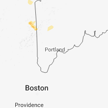
Hail Map for Saturday, June 30, 2018

Number of Impacted Households on 6/30/2018
0
Impacted by 1" or Larger Hail
0
Impacted by 1.75" or Larger Hail
0
Impacted by 2.5" or Larger Hail
Square Miles of Populated Area Impacted on 6/30/2018
0
Impacted by 1" or Larger Hail
0
Impacted by 1.75" or Larger Hail
0
Impacted by 2.5" or Larger Hail


Cities Most Affected by Hail Storms of 6/30/2018
| Hail Size | Demographics of Zip Codes Affected | ||||||
|---|---|---|---|---|---|---|---|
| City | Count | Average | Largest | Pop Density | House Value | Income | Age |
| Newberry, MI | 2 | 2.50 | 2.50 | 5 | $61k | $31.5k | 41.1 |
| Axtell, NE | 2 | 1.75 | 1.75 | 10 | $96k | $39.3k | 38.6 |
| Loomis, NE | 2 | 1.75 | 1.75 | 4 | $67k | $38.9k | 39.0 |
| Arapahoe, NE | 2 | 1.75 | 1.75 | 6 | $45k | $29.4k | 46.4 |
| Holdrege, NE | 1 | 2.75 | 2.75 | 30 | $72k | $37.2k | 43.2 |
| Bremen, KS | 1 | 2.00 | 2.00 | 5 | $53k | $33.1k | 45.7 |
| Saint Germain, WI | 1 | 1.75 | 1.75 | 59 | $130k | $35.6k | 52.4 |
| Minden, NE | 1 | 1.75 | 1.75 | 12 | $77k | $40.3k | 44.2 |
| Idalia, CO | 1 | 1.75 | 1.75 | 1 | $119k | $36.3k | 34.9 |
| Colby, KS | 1 | 1.75 | 1.75 | 13 | $79k | $37.3k | 35.7 |
| Ewing, NE | 1 | 1.75 | 1.75 | 2 | $34k | $30.5k | 44.4 |
| Goodland, KS | 1 | 1.75 | 1.75 | 9 | $65k | $33.1k | 41.5 |
| Eagle River, WI | 1 | 1.75 | 1.75 | 42 | $113k | $34.2k | 50.0 |
Hail and Wind Damage Spotted on 6/30/2018
Filter by Report Type:Hail ReportsWind Reports
States Impacted
Nebraska, Michigan, Iowa, Oklahoma, Arkansas, Florida, Minnesota, Mississippi, Colorado, Kansas, Missouri, Wisconsin, Texas, New HampshireNebraska
| Local Time | Report Details |
|---|---|
| 11:18 AM CDT | Golf Ball sized hail reported near Ewing, NE, 20.9 miles SE of Oneill, NE, estimated based off damage holes in siding |
| 2:40 PM CDT | Quarter sized hail reported near Arapahoe, NE, 75.6 miles SE of North Platte, NE |
| 2:46 PM CDT | Golf Ball sized hail reported near Arapahoe, NE, 75.6 miles SE of North Platte, NE |
| 2:56 PM CDT | Storm damage reported in furnas county NE, 75.6 miles SE of North Platte, NE |
| 3:06 PM CDT | 3 to 4 inch tree branches and severe signs down in town. flooding at intersection of highway 6 and 34. report received at 314 pm with time adjusted based on radar retur in furnas county NE, 72.8 miles SE of North Platte, NE |
| 3:13 PM CDT | Golf Ball sized hail reported near Arapahoe, NE, 73.4 miles SE of North Platte, NE, quarter to golf ball size hail for past 20 min. |
| 4:12 PM CDT | Baseball sized hail reported near Holdrege, NE, 67.3 miles WSW of Grand Island, NE |
| 4:14 PM CDT | Quarter sized hail reported near Auburn, NE, 61 miles S of Omaha, NE |
| 4:17 PM CDT | Golf Ball sized hail reported near Loomis, NE, 70.9 miles WSW of Grand Island, NE, golf ball and quarter size hail. |
| 4:17 PM CDT | Storm damage reported in phelps county NE, 70.9 miles WSW of Grand Island, NE |
| 4:19 PM CDT | Golf Ball sized hail reported near Axtell, NE, 52.9 miles SW of Grand Island, NE |
| 4:25 PM CDT | Golf Ball sized hail reported near Loomis, NE, 70.9 miles WSW of Grand Island, NE, also estimated 70 mph wind gusts and measured 1.65 rain with storm. |
| 4:27 PM CDT | Wind gust measured on portable anemomete in kearney county NE, 53.3 miles SW of Grand Island, NE |
| 3:48 PM MDT | Trained storm spotter with personal weather station recorded wind gusts of 55-60 mph along with a nearby spotter that also estimated 60 mph wind in kimball county NE, 45.8 miles SSE of Scottsbluff, NE |
| 4:53 PM CDT | Golf Ball sized hail reported near Axtell, NE, 52.2 miles SW of Grand Island, NE |
| 4:55 PM CDT | Storm damage reported in otoe county NE, 45.1 miles S of Omaha, NE |
| 5:01 PM CDT | Quarter sized hail reported near Nebraska City, NE, 41.7 miles S of Omaha, NE |
| 5:06 PM CDT | Golf Ball sized hail reported near Minden, NE, 44.6 miles SW of Grand Island, NE |
| 5:24 PM CDT | Storm damage reported in kearney county NE, 37.3 miles SW of Grand Island, NE |
| 5:55 PM CDT | Quarter sized hail reported near Glenvil, NE, 37.8 miles S of Grand Island, NE |
| 5:40 PM MDT | Estimated based off swaying of the trees in arthur county NE, 55.3 miles WNW of North Platte, NE |
| 6:40 PM CDT | Report of damage 8 to 9 miles south of sutton and 1 west. damaged the roof of a detached garage and part of the roof was gone to the house. water in the basement and tw in clay county NE, 39.6 miles SE of Grand Island, NE |
| 6:45 PM CDT | Report of road sign blown over at highway 77 and roca roa in lancaster county NE, 58.3 miles SW of Omaha, NE |
| 6:45 PM CDT | Delayed report. off duty nws employee reports 3 inch healthy tree limbs down on highway 4. time estimated from rada in nuckolls county NE, 49.1 miles SSE of Grand Island, NE |
| 7:17 PM CDT | A few small tree limbs down and pea size hai in mcpherson county NE, 46.3 miles NNW of North Platte, NE |
| 7:23 PM CDT | 3-4 inch tree limbs dow in lancaster county NE, 49.6 miles SW of Omaha, NE |
| 7:43 PM CDT | Storm damage reported in lancaster county NE, 51.3 miles WSW of Omaha, NE |
| 7:48 PM CDT | Small tree limbs dow in mcpherson county NE, 34.2 miles NNW of North Platte, NE |
| 7:53 PM CDT | Storm damage reported in lincoln county NE, 7.1 miles NW of North Platte, NE |
| 8:15 PM CDT | Utility poles snapped in half and cottonwood tree branches blown 80 yards at hwy 83 mm 118. time estimated by radar in logan county NE, 32.7 miles NNE of North Platte, NE |
| 8:25 PM CDT | Storm damage reported in saunders county NE, 29.2 miles W of Omaha, NE |
| 8:34 PM CDT | Wind driven horizontal heavy rainfall and pea size hai in logan county NE, 40.6 miles NE of North Platte, NE |
| 9:30 PM CDT | Storm damage reported in furnas county NE, 67.7 miles SSE of North Platte, NE |
| 12:00 AM CDT | Storm damage reported in fillmore county NE, 49.5 miles SE of Grand Island, NE |
| 12:03 AM CDT | Storm damage reported in fillmore county NE, 41.6 miles ESE of Grand Island, NE |
| 12:05 AM CDT | Storm damage reported in thayer county NE, 66.8 miles SE of Grand Island, NE |
| 12:07 AM CDT | Storm damage reported in fillmore county NE, 45.7 miles ESE of Grand Island, NE |
| 12:08 AM CDT | Report of camper blown over at junction of hwys 136 and 81 in thayer county near hebron. report of a person trapped insid in thayer county NE, 67.1 miles SE of Grand Island, NE |
Michigan
| Local Time | Report Details |
|---|---|
| 1:35 PM EDT | Tennis Ball sized hail reported near Newberry, MI, 62.2 miles WNW of Sault Sainte Marie, MI, muskallonge lake state park reports tennis ball size hail with numerous camper roofs destroyed. time estimated by radar. |
| 1:40 PM EDT | Tennis Ball sized hail reported near Newberry, MI, 60.2 miles W of Sault Sainte Marie, MI, law enforcement relayed report of windshield smashed by hail while driving from muskallonge lake state park to pine stump junction. size unknown but estimated based on |
| 6:15 PM EDT | Tree down on power line. additional tree down in the area. source is marquette county central dispatch. time based on rada in marquette county MI, 8.1 miles WNW of Marquette, MI |
| 7:05 PM EDT | Tree branch down blocking road. source is central dispatch. time estimated from rada in marquette county MI, 1.6 miles NW of Marquette, MI |
| 6:12 PM CDT | Several trees down in the watersmeet area. source is gogebic/iron central dispatch. time estimated from rada in gogebic county MI, 44.4 miles NNE of Rhinelander, WI |
| 7:45 PM EDT | Aspen trees blown down at the roots with diameters of up to 8 inches. report received via social medi in ontonagon county MI, 61.2 miles NNE of Rhinelander, WI |
Iowa
| Local Time | Report Details |
|---|---|
| 1:38 PM CDT | Quarter sized hail reported near Rolfe, IA, 36.4 miles ENE of Storm Lake, IA |
| 1:51 PM CDT | Half Dollar sized hail reported near Rolfe, IA, 36 miles ENE of Storm Lake, IA |
| 2:15 PM CDT | Corn laid flat by win in humboldt county IA, 48.3 miles ENE of Storm Lake, IA |
| 2:25 PM CDT | Large branches down along with nickle hai in humboldt county IA, 47 miles E of Storm Lake, IA |
| 2:30 PM CDT | Tree damage and one power line down outside of tow in wright county IA, 48.4 miles SW of Mason City, IA |
| 2:55 PM CDT | Tree limbs down due to thunderstorm wind in wright county IA, 46.4 miles SW of Mason City, IA |
| 3:07 PM CDT | Large tee limbs down all over tow in hancock county IA, 25.5 miles SW of Mason City, IA |
| 3:15 PM CDT | Ping Pong Ball sized hail reported near Clear Lake, IA, 7.6 miles W of Mason City, IA, via social media report. |
| 4:35 PM CDT | Trees and power lines down around county in winneshiek county IA, 44 miles SW of La Crosse, WI |
| 6:20 PM CDT | Quarter sized hail reported near Ankeny, IA, 11.7 miles N of Des Moines, IA, via social media picture. |
| 6:45 PM CDT | Em relays trained spotter report of 60 to 70 mph winds between 630 and 800 p in story county IA, 42.6 miles NNE of Des Moines, IA |
| 6:56 PM CDT | Storm damage reported in dallas county IA, 24.4 miles WNW of Des Moines, IA |
| 6:57 PM CDT | Minor damage to trees and power transformer in dallas county IA, 21.6 miles W of Des Moines, IA |
| 7:28 PM CDT | Trees downs in traer via social media. in tama county IA, 43.8 miles WNW of Cedar Rapids, IA |
| 7:30 PM CDT | Quarter sized hail reported near Creston, IA, 54.6 miles SW of Des Moines, IA |
| 8:31 PM CDT | Reports of tree branches down at least 2 inches diameter... a few 4 inches in diamete in guthrie county IA, 40.9 miles W of Des Moines, IA |
| 8:50 PM CDT | 7 inch tree branch down at 67th and meredit in polk county IA, 5.6 miles WNW of Des Moines, IA |
| 8:50 PM CDT | Report via social media. large tree branches down 6 to 10 inches in diamete in polk county IA, 6 miles NW of Des Moines, IA |
| 9:03 PM CDT | Roof blown off a house and a large tree down in tow in madison county IA, 27.2 miles SW of Des Moines, IA |
| 9:06 PM CDT | Storm damage reported in guthrie county IA, 40.4 miles WNW of Des Moines, IA |
| 9:07 PM CDT | Storm damage reported in guthrie county IA, 41.4 miles WNW of Des Moines, IA |
Oklahoma
| Local Time | Report Details |
|---|---|
| 1:40 PM CDT | Storm damage reported in tillman county OK, 26.1 miles NNW of Wichita Falls, TX |
| 1:46 PM CDT | Storm damage reported in tillman county OK, 44.2 miles NW of Wichita Falls, TX |
| 2:28 PM CDT | Storm damage reported in comanche county OK, 50 miles N of Wichita Falls, TX |
| 2:29 PM CDT | Se45 and hwy 7 in comanche county OK, 47.9 miles N of Wichita Falls, TX |
| 2:47 PM CDT | Quarter sized hail reported near Elgin, OK, 62.1 miles NNE of Wichita Falls, TX |
| 2:50 PM CDT | Storm damage reported in caddo county OK, 57.8 miles SW of Oklahoma City, OK |
| 3:14 PM CDT | Via spotter network in caddo county OK, 37.9 miles WSW of Oklahoma City, OK |
| 3:20 PM CDT | Mesonet reports 69mph wind gusts out of the southwes in grady county OK, 54.3 miles SSW of Oklahoma City, OK |
| 3:30 PM CDT | Mesonet measured 63mph gusts from the ss in grady county OK, 27.8 miles WSW of Oklahoma City, OK |
| 4:00 PM CDT | Storm damage reported in dewey county OK, 43.9 miles SSE of Woodward, OK |
| 4:10 PM CDT | Mesonet measured wind gusts up to 64mph from the wes in kingfisher county OK, 36.1 miles NW of Oklahoma City, OK |
| 4:50 PM CDT | Storm damage reported in major county OK, 70.8 miles NNW of Oklahoma City, OK |
| 5:45 PM CDT | Numerous trees damaged... large tree blown over in garvin county OK, 59.1 miles S of Oklahoma City, OK |
| 6:05 PM CDT | Storm damage reported in kay county OK, 52.9 miles S of Wichita, KS |
Arkansas
| Local Time | Report Details |
|---|---|
| 2:34 PM CDT | Trees down and limbs snapped. a few power pole cross arms broke in sharp county AR, 102.1 miles NNE of Little Rock, AR |
Florida
| Local Time | Report Details |
|---|---|
| 2:55 PM CDT | Mping wind damage report category of 1 inch tree limbs broken or shingles blown of in walton county FL, 24.2 miles NE of Miramar Beach, FL |
| 3:03 PM CDT | Mping wind damage report category of 1 inch tree limbs broken or shingles blown of in walton county FL, 21.3 miles ENE of Miramar Beach, FL |
| 4:03 PM CDT | One tree down on a powerline at john pitts road and joseph roa in bay county FL, 52.6 miles E of Miramar Beach, FL |
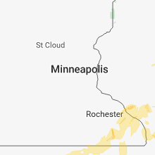
Minnesota
| Local Time | Report Details |
|---|---|
| 3:48 PM CDT | Quarter sized hail reported near Preston, MN, 45.5 miles WSW of La Crosse, WI |
| 4:35 PM CDT | Quarter sized hail reported near Winona, MN, 24.1 miles WNW of La Crosse, WI |
| 5:45 PM CDT | Reported via twitter. photo shows two large tree branches that were downed near halverson elementary school. one large branch landed on the roof of a home. time was est in freeborn county MN, 35.8 miles NNW of Mason City, IA |
| 6:20 PM CDT | Numerous reports of trees and power lines down in and west of austi in mower county MN, 38 miles NNE of Mason City, IA |
| 6:35 PM CDT | Trees down in austin in mower county MN, 38 miles NNE of Mason City, IA |
| 6:54 PM CDT | Storm damage reported in olmsted county MN, 62.7 miles W of La Crosse, WI |
| 7:15 PM CDT | Trees down in town in fillmore county MN, 36.5 miles W of La Crosse, WI |
| 7:39 PM CDT | Storm damage reported in winona county MN, 41.8 miles WNW of La Crosse, WI |
Mississippi
| Local Time | Report Details |
|---|---|
| 4:20 PM CDT | The canopy of a gas station on ms hwy 16 was collapsed by strong win in neshoba county MS, 52.4 miles SSW of Starkville, MS |
| 5:50 PM CDT | A large pine tree was blown down on a house on county road 1537... destroying it. the wood framing of a new house being built next door was blown dow in jasper county MS, 57.4 miles ESE of Jackson, MS |
| 6:41 PM CDT | Tree downed across ms highway 18 at gabe holcomb r in rankin county MS, 29.2 miles ESE of Jackson, MS |
| 8:13 PM CDT | Trees down over the roadway near arlington rd and arlington loop northeast of beaumont... m in perry county MS, 59.2 miles NW of Mobile, AL |
| 8:18 PM CDT | Corrects previous tstm wnd dmg report from 3 ese beaumont. trees down over a power-line at the corner of cicero rd and hwy 9 in perry county MS, 58.2 miles WNW of Mobile, AL |
Colorado
| Local Time | Report Details |
|---|---|
| 3:25 PM MDT | Quarter sized hail reported near Colorado Springs, CO, 34.9 miles N of Pueblo, CO |
| 3:37 PM MDT | Quarter sized hail reported near Colorado Springs, CO, 42.5 miles N of Pueblo, CO |
| 3:38 PM MDT | Quarter sized hail reported near Colorado Springs, CO, 44.4 miles NNW of Pueblo, CO |
| 3:39 PM MDT | Ping Pong Ball sized hail reported near Colorado Springs, CO, 43.4 miles NNW of Pueblo, CO |
| 4:37 PM MDT | Quarter sized hail reported near Colorado Springs, CO, 43.4 miles NNW of Pueblo, CO |
| 4:39 PM MDT | Quarter sized hail reported near Eaton, CO, 56.5 miles NNE of Denver, CO |
| 4:42 PM MDT | Quarter sized hail reported near Colorado Springs, CO, 44.1 miles NNW of Pueblo, CO |
| 4:45 PM MDT | Quarter sized hail reported near Colorado Springs, CO, 43.5 miles N of Pueblo, CO |
| 4:46 PM MDT | Quarter sized hail reported near Colorado Springs, CO, 43.1 miles N of Pueblo, CO |
| 4:48 PM MDT | Quarter sized hail reported near Colorado Springs, CO, 43.7 miles N of Pueblo, CO |
| 4:48 PM MDT | Quarter sized hail reported near Colorado Springs, CO, 42.2 miles N of Pueblo, CO |
| 4:48 PM MDT | Quarter sized hail reported near Colorado Springs, CO, 45.4 miles NNW of Pueblo, CO |
| 4:52 PM MDT | Half Dollar sized hail reported near Colorado Springs, CO, 43.1 miles N of Pueblo, CO |
| 4:54 PM MDT | Quarter sized hail reported near Bellvue, CO, 49.5 miles SSE of Laramie, WY |
| 6:03 PM MDT | Quarter sized hail reported near Colorado Springs, CO, 41.6 miles N of Pueblo, CO |
| 6:10 PM MDT | Storm damage reported in yuma county CO, 19.5 miles SE of Yuma, CO |
| 6:26 PM MDT | Golf Ball sized hail reported near Idalia, CO, 37.2 miles SSE of Yuma, CO |
| 6:26 PM MDT | Reported est winds between 40 to 60 mp in yuma county CO, 37.2 miles SSE of Yuma, CO |
| 6:38 PM MDT | Ping Pong Ball sized hail reported near Idalia, CO, 42.3 miles SSE of Yuma, CO |
| 6:48 PM MDT | Storm damage reported in yuma county CO, 44.8 miles SE of Yuma, CO |
| 6:53 PM MDT | Storm damage reported in yuma county CO, 44.8 miles SE of Yuma, CO |
| 7:27 PM MDT | Public sent a picture of an irrigation pivot blown ove in yuma county CO, 42.3 miles SE of Yuma, CO |
| 7:27 PM MDT | Ping Pong Ball sized hail reported near Burlington, CO, 42.3 miles SE of Yuma, CO, public reported ping pong ball size hail. |
Kansas
| Local Time | Report Details |
|---|---|
| 4:40 PM CDT | Storm damage reported in pottawatomie county KS, 14.1 miles NNE of Manhattan, KS |
| 4:53 PM CDT | Storm damage reported in marshall county KS, 28.5 miles N of Manhattan, KS |
| 5:26 PM CDT | Storm damage reported in nemaha county KS, 46.8 miles NNE of Manhattan, KS |
| 5:30 PM CDT | 3-4 power poles down and a roof blown off of a structur in marshall county KS, 57.8 miles N of Manhattan, KS |
| 5:30 PM CDT | Porch and part of a roof was blown off a hom in marshall county KS, 57.1 miles NNE of Manhattan, KS |
| 5:49 PM CDT | At 300 west and 10 road. via kake t in harper county KS, 54.8 miles SW of Wichita, KS |
| 5:50 PM CDT | Power poles down at franklin street and hayes steet in town. road blocke in harper county KS, 53.2 miles SW of Wichita, KS |
| 5:50 PM CDT | Tree blown down on a roa in jackson county KS, 47.6 miles ENE of Manhattan, KS |
| 5:56 PM CDT | Estimated winds of 50-65mph in harper county KS, 47 miles SW of Wichita, KS |
| 6:06 PM CDT | Storm damage reported in nemaha county KS, 50.6 miles NNE of Manhattan, KS |
| 6:08 PM CDT | Tree limbs dow in jackson county KS, 42.9 miles NE of Manhattan, KS |
| 6:08 PM CDT | Storm damage reported in brown county KS, 57.2 miles NE of Manhattan, KS |
| 6:15 PM CDT | Storm damage reported in harper county KS, 47.8 miles SW of Wichita, KS |
| 6:33 PM CDT | Storm damage reported in cowley county KS, 40 miles SSE of Wichita, KS |
| 6:34 PM CDT | Estimated 60mph wind gusts in marion county KS, 37.8 miles NNE of Wichita, KS |
| 6:40 PM CDT | 4 inch tree limb down at nws offic in sedgwick county KS, 6 miles WSW of Wichita, KS |
| 6:43 PM CDT | Storm damage reported in brown county KS, 59.9 miles NW of Kansas City, MO |
| 6:47 PM CDT | Kayaker was blown off of a kayak at cowley co. fishing lake. blown to the far shore. injuries unknow in cowley county KS, 50.8 miles SSE of Wichita, KS |
| 6:48 PM CDT | Ping Pong Ball sized hail reported near Peabody, KS, 35.5 miles NNE of Wichita, KS, ping pong ball size hail... 60mph winds... downed powerlines... and heavy rain reported in peabody to em |
| 6:49 PM CDT | Located 3 miles south of the butler/cowley co. line on us highway 7 in cowley county KS, 23 miles SE of Wichita, KS |
| 6:49 PM CDT | Tree branches reported down in town. via social medi in sedgwick county KS, 0.3 miles NW of Wichita, KS |
| 6:52 PM CDT | Storm damage reported in cowley county KS, 25.2 miles SE of Wichita, KS |
| 6:54 PM CDT | Estimated at winfield city lak in cowley county KS, 34.6 miles SE of Wichita, KS |
| 7:01 PM CDT | Storm damage reported in douglas county KS, 34.9 miles W of Kansas City, MO |
| 7:03 PM CDT | Storm damage reported in cowley county KS, 40.5 miles SE of Wichita, KS |
| 7:05 PM CDT | Storm damage reported in douglas county KS, 34.9 miles W of Kansas City, MO |
| 7:05 PM CDT | Tree limbs dow in douglas county KS, 38.7 miles SW of Kansas City, MO |
| 7:08 PM CDT | Storm damage reported in sedgwick county KS, 7.7 miles NE of Wichita, KS |
| 7:41 PM CDT | Storm damage reported in douglas county KS, 30.8 miles WSW of Kansas City, MO |
| 8:00 PM CDT | Emergency management reports an 8 inch tree limb down on kansas highway 3 in leavenworth county KS, 24.4 miles WSW of Kansas City, MO |
| 8:08 PM CDT | Storm damage reported in cheyenne county KS, 47.8 miles WNW of Colby, KS |
| 8:13 PM CDT | Quarter sized hail reported near De Soto, KS, 22 miles WSW of Kansas City, MO |
| 8:13 PM CDT | Two foot diameter tree down over stillwell roa in leavenworth county KS, 20.2 miles WSW of Kansas City, MO |
| 8:15 PM CDT | Very large tree limb blown down in town. estimated time of report from rada in graham county KS, 44.3 miles NW of Hays, KS |
| 7:21 PM MDT | Facebook repor in sherman county KS, 40.4 miles W of Colby, KS |
| 7:21 PM MDT | Storm damage reported in sherman county KS, 35.1 miles W of Colby, KS |
| 7:22 PM MDT | Asos station gld... goodlan in sherman county KS, 35.1 miles W of Colby, KS |
| 7:23 PM MDT | Half Dollar sized hail reported near Goodland, KS, 36 miles W of Colby, KS |
| 7:23 PM MDT | Golf Ball sized hail reported near Goodland, KS, 36 miles W of Colby, KS, hail ranged from dime to golf ball in size. corrects previous hail report from 9 n goodland. |
| 7:23 PM MDT | Road barricades were blown a quarter to half a block as the thunderstorm winds moved through tow in sherman county KS, 35.2 miles W of Colby, KS |
| 7:23 PM MDT | Several 4-5" diameter tree limbs were blown dow in sherman county KS, 36.3 miles W of Colby, KS |
| 7:23 PM MDT | Large fire works tent was blown down from the thunderstorm wind in sherman county KS, 37 miles W of Colby, KS |
| 8:28 PM CDT | Quarter sized hail reported near Hill City, KS, 40.1 miles NW of Hays, KS, started out as pea size then grew to quarter size. estimated time of report from radar. |
| 8:28 PM CDT | Large tree limbs estimated at 5" in diameter blown down. estimated time of report from rada in graham county KS, 40.1 miles NW of Hays, KS |
| 8:29 PM CDT | Em called and reported the trees were being blown over and a shed blow over his hous in cheyenne county KS, 35 miles WNW of Colby, KS |
| 7:30 PM MDT | The duration of the tstm wnd gst event was 3 minute in sherman county KS, 36 miles W of Colby, KS |
| 8:38 PM CDT | Trained spotter reported wind gusts up to 70mph. tree limbs up to 5 inches snapped of in rawlins county KS, 34.4 miles N of Colby, KS |
| 7:40 PM MDT | Half Dollar sized hail reported near Goodland, KS, 32.1 miles WNW of Colby, KS |
| 7:40 PM MDT | Mesonet station k5ed7... 2 w edso in sherman county KS, 29 miles W of Colby, KS |
| 7:40 PM MDT | Est 60 to 70 mp in sherman county KS, 32.1 miles WNW of Colby, KS |
| 7:43 PM MDT | Storm damage reported in sherman county KS, 32.1 miles WNW of Colby, KS |
| 8:46 PM CDT | Storm damage reported in rawlins county KS, 28.5 miles N of Colby, KS |
| 7:47 PM MDT | Nws employee reported wind gusts up to 60mp in sherman county KS, 35.2 miles W of Colby, KS |
| 8:50 PM CDT | Corrects previous tstm wnd dmg report from colby. several power poles were damaged due to the thunderstorm winds. all of colby is without powe in thomas county KS, 0.3 miles NW of Colby, KS |
| 8:54 PM CDT | Half Dollar sized hail reported near Bremen, KS, 52.3 miles NNW of Manhattan, KS |
| 8:54 PM CDT | Hen Egg sized hail reported near Bremen, KS, 51.2 miles NNW of Manhattan, KS |
| 9:00 PM CDT | Broken window at orschlen in thomas county KS, 1.9 miles S of Colby, KS |
| 9:00 PM CDT | Thunderstorm winds brought down power lines at the k-state research extension grounds. this caused a small fire but rain put out the fire before any damage was don in thomas county KS, 0.9 miles WSW of Colby, KS |
| 9:02 PM CDT | Golf Ball sized hail reported near Colby, KS, 0.3 miles NW of Colby, KS |
| 9:03 PM CDT | Twitter report with a pic of handheld wind anemomete in thomas county KS, 0.9 miles WSW of Colby, KS |
| 9:03 PM CDT | Storm damage reported in thomas county KS, 2.3 miles N of Colby, KS |
| 9:07 PM CDT | Large tree limb fell on hous in coffey county KS, 35.4 miles N of Chanute, KS |
| 9:21 PM CDT | Storm damage reported in logan county KS, 23.2 miles SSE of Colby, KS |
| 9:22 PM CDT | Storm damage reported in logan county KS, 23.2 miles SSE of Colby, KS |
| 9:27 PM CDT | Storm damage reported in gove county KS, 28.9 miles SE of Colby, KS |
| 9:30 PM CDT | Large tree down in the city of garnet in anderson county KS, 42.8 miles NNE of Chanute, KS |
| 9:36 PM CDT | Storm damage reported in sheridan county KS, 32 miles E of Colby, KS |
| 9:40 PM CDT | Multiple large tree limbs blown down in tow in sheridan county KS, 32.6 miles E of Colby, KS |
| 9:40 PM CDT | 4" metal flag pole bent in half by the thunderstorm wind in sheridan county KS, 32.5 miles E of Colby, KS |
| 9:45 PM CDT | A 20 inch diameter tree fell on a house and took down a power lin in shawnee county KS, 49.9 miles ESE of Manhattan, KS |
| 9:55 PM CDT | Small tree limbs dow in douglas county KS, 38.8 miles WSW of Kansas City, MO |
| 10:00 PM CDT | Corrects previous tstm wnd dmg report from 12 s wheeler. power was out until 10 pm c in cheyenne county KS, 37.5 miles WNW of Colby, KS |
| 10:03 PM CDT | Storm damage reported in douglas county KS, 37.8 miles WSW of Kansas City, MO |
| 10:03 PM CDT | Multiple tree limbs dow in jefferson county KS, 39.1 miles W of Kansas City, MO |
| 10:05 PM CDT | Storm damage reported in gove county KS, 47.3 miles SE of Colby, KS |
| 10:13 PM CDT | Measured 60-70 mph wind gusts as storm first moved throug in gove county KS, 45.2 miles WNW of Hays, KS |
| 10:13 PM CDT | Significant damage at a farm... including ripped off sheet metal. 1 to 2 inch diameter tree branches snapped of in jefferson county KS, 36.9 miles W of Kansas City, MO |
| 10:54 PM CDT | Storm damage reported in finney county KS, 8.6 miles ESE of Garden City, KS |
| 11:04 PM CDT | Khys awos recorded 72 mph wind gus in ellis county KS, 3.4 miles ESE of Hays, KS |
| 11:05 PM CDT | Mesonet site: hask in ellis county KS, 1.7 miles SSW of Hays, KS |
| 11:29 PM CDT | Storm damage reported in russell county KS, 29.2 miles ENE of Hays, KS |
| 12:48 AM CDT | Power was out until 10 pm c in cheyenne county KS, 37.5 miles WNW of Colby, KS |
Missouri
| Local Time | Report Details |
|---|---|
| 4:43 PM CDT | Quarter sized hail reported near Platte City, MO, 19.2 miles NNW of Kansas City, MO |
Wisconsin
| Local Time | Report Details |
|---|---|
| 5:01 PM CDT | Storm damage reported in la crosse county WI, 4 miles N of La Crosse, WI |
| 5:07 PM CDT | Quarter sized hail reported near Saint Germain, WI, 19 miles N of Rhinelander, WI |
| 5:08 PM CDT | Half Dollar sized hail reported near Saint Germain, WI, 19 miles N of Rhinelander, WI |
| 5:08 PM CDT | Golf Ball sized hail reported near Saint Germain, WI, 19 miles N of Rhinelander, WI |
| 5:10 PM CDT | Large tree branch down blocking gillette stree in la crosse county WI, 2.8 miles NNE of La Crosse, WI |
| 5:35 PM CDT | Trees and power lines down in crawford county WI, 37.9 miles SE of La Crosse, WI |
| 5:37 PM CDT | Golf Ball sized hail reported near Eagle River, WI, 20.3 miles NNE of Rhinelander, WI |
| 5:50 PM CDT | Reported at smart hollow rd and county rd f vernon county... wi. time estimated from rada in vernon county WI, 27.5 miles ESE of La Crosse, WI |
| 6:09 PM CDT | Branches down and power outage on north side of city in richland county WI, 53.4 miles WNW of Madison, WI |
| 6:15 PM CDT | Trees reported dow in juneau county WI, 52.9 miles ESE of La Crosse, WI |
| 6:17 PM CDT | Numerous trees and power lines down at hwy 82 and county road in vernon county WI, 36.3 miles ESE of La Crosse, WI |
| 6:30 PM CDT | Trees down all over sauk county. time estimated from rada in sauk county WI, 32.7 miles NNW of Madison, WI |
| 6:35 PM CDT | Trees and power lines downe in adams county WI, 56 miles NNW of Madison, WI |
| 6:40 PM CDT | Time estimated. trees and power lines downe in adams county WI, 46.2 miles NNW of Madison, WI |
| 6:48 PM CDT | Moderate sized tree branches down on roads. tops of trees sheared of in sauk county WI, 44.7 miles NW of Madison, WI |
| 6:55 PM CDT | Few trees down. report relayed by waow and wsaw t in marathon county WI, 56.4 miles SSW of Rhinelander, WI |
| 7:00 PM CDT | Trees and power lines down all over marquette county. time estimated from rada in marquette county WI, 49.6 miles N of Madison, WI |
| 7:05 PM CDT | Top half of tree down. time estimated from radar. relayed via social medi in columbia county WI, 32.5 miles N of Madison, WI |
| 7:10 PM CDT | 3 reports of trees down in wyocena. one report of trees down in marcellon township and one report in fort winnebago. time estimated from rada in columbia county WI, 29.1 miles N of Madison, WI |
| 7:30 PM CDT | Trees down in yellowstone lake state park area. time estimated from rada in lafayette county WI, 36.2 miles SW of Madison, WI |
| 7:30 PM CDT | Tree damage with 6 inch limbs broken. time estimated based on rada in dane county WI, 6.4 miles NNW of Madison, WI |
| 7:52 PM CDT | Trees reported down in la crosse county WI, 9.1 miles NNW of La Crosse, WI |
Texas
| Local Time | Report Details |
|---|---|
| 9:30 PM CDT | Ping Pong Ball sized hail reported near Cactus, TX, 58.3 miles N of Amarillo, TX |
| 9:30 PM CDT | Power lines blown down near and on the road along highway 287 just north of cactus. time estimate in moore county TX, 59.6 miles N of Amarillo, TX |
| 11:22 PM CDT | Quarter sized hail reported near Perryton, TX, 85.6 miles NE of Amarillo, TX, nickel to quarter size hail reported |
| 11:22 PM CDT | Storm damage reported in ochiltree county TX, 85.6 miles NE of Amarillo, TX |
New Hampshire
| Local Time | Report Details |
|---|---|
| 10:38 PM EDT | Quarter sized hail reported near Berlin, NH, 72.8 miles NW of Portland, ME, facebook report |
Connect with Interactive Hail Maps