

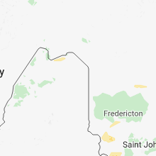
Hail Map for Friday, June 29, 2018

Number of Impacted Households on 6/29/2018
0
Impacted by 1" or Larger Hail
0
Impacted by 1.75" or Larger Hail
0
Impacted by 2.5" or Larger Hail
Square Miles of Populated Area Impacted on 6/29/2018
0
Impacted by 1" or Larger Hail
0
Impacted by 1.75" or Larger Hail
0
Impacted by 2.5" or Larger Hail


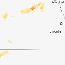


Cities Most Affected by Hail Storms of 6/29/2018
| Hail Size | Demographics of Zip Codes Affected | ||||||
|---|---|---|---|---|---|---|---|
| City | Count | Average | Largest | Pop Density | House Value | Income | Age |
| Piedmont, SD | 4 | 2.56 | 3.00 | 23 | $88k | $41.5k | 41.4 |
| Lead, SD | 3 | 2.42 | 3.00 | 16 | $52k | $31.3k | 44.6 |
| Newell, SD | 1 | 4.50 | 4.50 | 1 | $38k | $25.9k | 47.2 |
| Sundance, WY | 2 | 2.13 | 2.50 | 1 | $87k | $39.7k | 47.3 |
| Mud Butte, SD | 1 | 3.00 | 3.00 | 0 | $45k | $30.2k | 41.0 |
| Belle Fourche, SD | 1 | 2.75 | 2.75 | 6 | $67k | $30.1k | 39.3 |
| Fort Pierre, SD | 1 | 2.00 | 2.00 | 2 | $85k | $41.6k | 41.8 |
| Deadwood, SD | 1 | 2.00 | 2.00 | 18 | $78k | $32.3k | 48.5 |
| Sturgis, SD | 1 | 2.00 | 2.00 | 15 | $79k | $34.9k | 44.7 |
| Gillette, WY | 1 | 1.75 | 1.75 | 17 | $94k | $42.4k | 32.2 |
| Highmore, SD | 1 | 1.75 | 1.75 | 1 | $35k | $30.0k | 48.2 |
| Edgemont, SD | 1 | 1.75 | 1.75 | 0 | $29k | $30.1k | 50.0 |
| Black Hawk, SD | 1 | 1.75 | 1.75 | 282 | $89k | $44.6k | 36.6 |
| Rozet, WY | 1 | 1.75 | 1.75 | 2 | $87k | $58.0k | 34.6 |
Hail and Wind Damage Spotted on 6/29/2018
Filter by Report Type:Hail ReportsWind Reports
States Impacted
Minnesota, Michigan, Maine, North Dakota, Wyoming, South Dakota, South Carolina, Colorado, Texas, Kansas, NebraskaMinnesota
| Local Time | Report Details |
|---|---|
| 7:00 AM CDT | Deck boxes and furniture blown off deck. 2.01 inches of rain. reported via social medi in beltrami county MN, 3.9 miles N of Bemidji, MN |
| 7:05 AM CDT | Report and photograph of a large tree branch down. the branch is 3 inches in diamete in itasca county MN, 62.7 miles NW of Duluth, MN |
| 7:07 AM CDT | Quarter sized hail reported near Mountain Iron, MN, 58.9 miles NNW of Duluth, MN, mping report of quarter size hail. |
| 7:08 AM CDT | Several pine trees ripped up at the roots and knocked down near elbow lake. time estimated by rada in st. louis county MN, 54.5 miles SE of International Falls, MN |
| 7:14 AM CDT | Lots of trees and powerlines downed. time estimated by rada in st. louis county MN, 58.3 miles NW of Duluth, MN |
| 7:18 AM CDT | Wind gust measured at awos station kcq in st. louis county MN, 63.3 miles SSE of International Falls, MN |
| 7:34 AM CDT | 20 inch diameter tree snapped on kapla lake road. time estimated by rada in st. louis county MN, 49.6 miles NNW of Duluth, MN |
| 7:35 AM CDT | Lots of trees and power lines downed. time estimated by rada in st. louis county MN, 50.9 miles NNW of Duluth, MN |
| 7:38 AM CDT | Trees are down in the ely area... including on power lines. the power is ou in st. louis county MN, 78.4 miles N of Duluth, MN |
| 7:42 AM CDT | 20 inch diameter tree toppled and power line knocked dow in st. louis county MN, 63.4 miles N of Duluth, MN |
| 7:55 AM CDT | Measured by a personal weather station on moose lake road. time estimated by rada in lake county MN, 86.9 miles NNE of Duluth, MN |
| 8:04 AM CDT | Wind gust measured by station elom in st. louis county MN, 73 miles N of Duluth, MN |
| 8:34 AM CDT | Tree knocked down near the intersection of highway 61 and temperance road. time estimated by rada in cook county MN, 77.9 miles NE of Duluth, MN |
| 8:45 AM CDT | Corrects previous tstm wnd dmg report from 1 sse tofte. tree knocked down near the intersection of highway 61 and temperance road. time estimated by rada in cook county MN, 77.9 miles NE of Duluth, MN |
| 8:58 AM CDT | The algoma guardian reported a gust of 55 knot in lsz162 county MN, 60 miles ENE of Duluth, MN |
| 12:45 AM CDT | Power line blown down near cr 3 and bird lake roa in douglas county MN, 70.7 miles NNE of Montevideo, MN |
| 12:55 AM CDT | Tree blown down on power lin in todd county MN, 71.2 miles NNE of Montevideo, MN |
| 1:10 AM CDT | Tree blown down onto power lin in todd county MN, 81.8 miles NE of Montevideo, MN |
| 1:25 AM CDT | Power line blown dow in morrison county MN, 84.9 miles NE of Montevideo, MN |
| 1:40 AM CDT | Power line blown dow in morrison county MN, 90 miles NW of Minneapolis, MN |
| 1:55 AM CDT | Measured at little falls airpor in morrison county MN, 85.3 miles NW of Minneapolis, MN |
| 2:13 AM CDT | Storm damage reported in morrison county MN, 80.2 miles NNW of Minneapolis, MN |
| 3:25 AM CDT | Quarter sized hail reported near Cloquet, MN, 17.7 miles WSW of Duluth, MN |
Michigan
| Local Time | Report Details |
|---|---|
| 11:00 AM EDT | Time estimated by rada in lsz263 county MI, 112.6 miles ENE of Duluth, MN |
| 11:15 AM EDT | Trees down over road. source is state police regional dispatc in ontonagon county MI, 81.2 miles N of Rhinelander, WI |
| 11:30 AM EDT | Downed power poles. source is state police regional dispatc in ontonagon county MI, 79 miles N of Rhinelander, WI |
| 11:30 AM EDT | Barn destroyed. report is from social medi in ontonagon county MI, 80.2 miles N of Rhinelander, WI |
| 11:41 AM EDT | Storm damage reported in houghton county MI, 78.3 miles WNW of Marquette, MI |
| 11:45 AM EDT | Photos received of three trees downed at mcclain state park. time estimated by rada in houghton county MI, 74.2 miles NW of Marquette, MI |
| 11:46 AM EDT | Also pea size hai in houghton county MI, 78.3 miles WNW of Marquette, MI |
| 11:50 AM EDT | Birch tree down in elo... south of tapiola. delayed report via social medi in houghton county MI, 62.4 miles WNW of Marquette, MI |
| 11:55 AM EDT | Houghton county airport observatio in houghton county MI, 66.4 miles NW of Marquette, MI |
| 12:05 PM EDT | Trees down on power lines. source is state police regional dispatc in baraga county MI, 50.9 miles WNW of Marquette, MI |
| 12:30 PM EDT | Tree down. report is from social medi in baraga county MI, 40.4 miles W of Marquette, MI |
Maine
| Local Time | Report Details |
|---|---|
| 12:55 PM EDT | Multiple trees down on klein roa in aroostook county ME, 38.9 miles NW of Caribou, ME |
| 1:40 PM EDT | Three trees dow in aroostook county ME, 14.1 miles NE of Caribou, ME |
| 2:00 PM EDT | Power lines dow in aroostook county ME, 9.3 miles ENE of Caribou, ME |
| 2:30 PM EDT | Tree down on power lines. on fir in aroostook county ME, 20.4 miles SSE of Caribou, ME |
North Dakota
| Local Time | Report Details |
|---|---|
| 1:50 PM CDT | Large swath (about 1 mile long) of extensive thunderstorm wind damage from an intense squall line that moved through the area during the early morning hours on june 29t in mclean county ND, 45.2 miles NNW of Bismarck, ND |
Wyoming
| Local Time | Report Details |
|---|---|
| 2:03 PM MDT | Golf Ball sized hail reported near Gillette, WY, 20.8 miles NNW of Gillette, WY |
| 2:37 PM MDT | Quarter sized hail reported near Weston, WY, 28.1 miles NNE of Gillette, WY, 65 mph wind |
| 2:50 PM MDT | Lots of pea size hail in campbell county WY, 7 miles NNE of Gillette, WY |
| 3:17 PM MDT | Golf Ball sized hail reported near Rozet, WY, 21 miles ENE of Gillette, WY |
| 3:27 PM MDT | Ping Pong Ball sized hail reported near Hulett, WY, 52.1 miles ENE of Gillette, WY |
| 3:30 PM MDT | Half Dollar sized hail reported near Hulett, WY, 52.1 miles ENE of Gillette, WY |
| 3:35 PM MDT | Half Dollar sized hail reported near Moorcroft, WY, 35.9 miles ENE of Gillette, WY, large hail from 335 pm to 340 pm. combination of hail and wind gusts to 40 mph caused minor damage. |
| 3:38 PM MDT | Ping Pong Ball sized hail reported near Moorcroft, WY, 37.2 miles ENE of Gillette, WY |
| 3:38 PM MDT | Storm damage reported in crook county WY, 37.2 miles ENE of Gillette, WY |
| 3:50 PM MDT | Golf Ball sized hail reported near Sundance, WY, 56.7 miles E of Gillette, WY, shattered windshield |
| 3:52 PM MDT | Quarter sized hail reported near Sundance, WY, 57.9 miles WNW of Rapid City, SD |
| 4:03 PM MDT | Tennis Ball sized hail reported near Sundance, WY, 56.7 miles E of Gillette, WY, peak wind 56 mph. lots of tree branches down... some screens torn out of windows. |
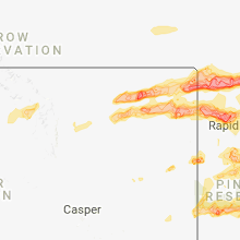
South Dakota
| Local Time | Report Details |
|---|---|
| 4:15 PM MDT | Storm damage reported in butte county SD, 54.6 miles NW of Rapid City, SD |
| 4:22 PM MDT | Baseball sized hail reported near Belle Fourche, SD, 58.4 miles NNW of Rapid City, SD |
| 4:35 PM MDT | Quarter sized hail reported near Spearfish, SD, 42.5 miles NW of Rapid City, SD |
| 4:36 PM MDT | Storm damage reported in butte county SD, 50.1 miles NW of Rapid City, SD |
| 4:42 PM MDT | Golf Ball sized hail reported near Lead, SD, 32.2 miles NW of Rapid City, SD, heavy rainfall |
| 4:42 PM MDT | Tennis Ball sized hail reported near Lead, SD, 32.6 miles NW of Rapid City, SD |
| 4:42 PM MDT | Tea Cup sized hail reported near Lead, SD, 32.6 miles NW of Rapid City, SD, broken house windows |
| 4:45 PM MDT | Hen Egg sized hail reported near Deadwood, SD, 32.2 miles NW of Rapid City, SD |
| 4:46 PM MDT | Ping Pong Ball sized hail reported near Belle Fourche, SD, 67.4 miles NNW of Rapid City, SD |
| 4:49 PM MDT | Softball sized hail reported near Newell, SD, 47.9 miles N of Rapid City, SD, shattered windshield |
| 5:01 PM MDT | Ping Pong Ball sized hail reported near Whitewood, SD, 33.6 miles NNW of Rapid City, SD |
| 5:08 PM MDT | Hen Egg sized hail reported near Sturgis, SD, 21.8 miles NNW of Rapid City, SD, golfball to tennis ball size |
| 5:08 PM MDT | Hen Egg sized hail reported near Piedmont, SD, 18.1 miles NNW of Rapid City, SD, lots of golf ball size hail and as big as 2" |
| 5:10 PM MDT | Storm damage reported in butte county SD, 59.1 miles NNE of Rapid City, SD |
| 5:18 PM MDT | Tea Cup sized hail reported near Piedmont, SD, 16.1 miles NW of Rapid City, SD, hailstone was found 2 hours after the storm. likely was much larger than 3 inches when it fell. |
| 5:18 PM MDT | Hen Egg sized hail reported near Piedmont, SD, 13.8 miles NW of Rapid City, SD |
| 5:19 PM MDT | Quarter sized hail reported near Edgemont, SD, 40.9 miles SW of Rapid City, SD, lots of nickle sized hail with some quarter. |
| 5:22 PM MDT | Quarter sized hail reported near Piedmont, SD, 12.1 miles NW of Rapid City, SD |
| 5:24 PM MDT | Golf Ball sized hail reported near Black Hawk, SD, 8.7 miles NW of Rapid City, SD |
| 5:28 PM MDT | Quarter sized hail reported near Mud Butte, SD, 62.9 miles NNE of Rapid City, SD |
| 5:30 PM MDT | Tea Cup sized hail reported near Piedmont, SD, 11.9 miles NNW of Rapid City, SD |
| 5:40 PM MDT | Pea size hail in meade county SD, 14 miles NE of Rapid City, SD |
| 5:48 PM MDT | Storm damage reported in pennington county SD, 15.2 miles E of Rapid City, SD |
| 5:54 PM MDT | Tea Cup sized hail reported near Mud Butte, SD, 65.9 miles NE of Rapid City, SD |
| 6:14 PM MDT | Storm damage reported in pennington county SD, 36.4 miles E of Rapid City, SD |
| 6:17 PM MDT | Golf Ball sized hail reported near Edgemont, SD, 68.5 miles SSW of Rapid City, SD, lots of pea size hail with golf ball |
| 6:22 PM MDT | Quarter sized hail reported near Hermosa, SD, 22.9 miles S of Rapid City, SD, lots of quarter size hail |
| 6:24 PM MDT | Storm damage reported in meade county SD, 79.3 miles NE of Rapid City, SD |
| 6:24 PM MDT | Quarter sized hail reported near Faith, SD, 79.3 miles NE of Rapid City, SD |
| 6:24 PM MDT | Storm damage reported in custer county SD, 27.7 miles S of Rapid City, SD |
| 6:30 PM MDT | Quarter sized hail reported near Edgemont, SD, 61.7 miles SSW of Rapid City, SD, lot of pea size hail with some quarter |
| 6:44 PM MDT | Ping Pong Ball sized hail reported near Hot Springs, SD, 39.7 miles SSW of Rapid City, SD |
| 6:44 PM MDT | Storm damage reported in ziebach county SD, 71.6 miles ENE of Rapid City, SD |
| 6:44 PM MDT | Ping Pong Ball sized hail reported near Buffalo Gap, SD, 39.1 miles S of Rapid City, SD |
| 6:45 PM MDT | Ping Pong Ball sized hail reported near Hot Springs, SD, 39.7 miles SSW of Rapid City, SD |
| 6:45 PM MDT | Time estimated from radar in pennington county SD, 51.3 miles ESE of Rapid City, SD |
| 6:52 PM MDT | Quarter sized hail reported near Hot Springs, SD, 46.1 miles SSW of Rapid City, SD |
| 7:08 PM MDT | Storm damage reported in haakon county SD, 65.9 miles WSW of Pierre, SD |
| 7:10 PM MDT | Heavy rain in ziebach county SD, 64.8 miles WNW of Pierre, SD |
| 7:14 PM MDT | Storm damage reported in haakon county SD, 56.1 miles W of Pierre, SD |
| 7:20 PM MDT | Storm damage reported in haakon county SD, 44.9 miles W of Pierre, SD |
| 7:24 PM MDT | Storm damage reported in stanley county SD, 44.2 miles WNW of Pierre, SD |
| 7:25 PM MDT | Storm damage reported in stanley county SD, 32.7 miles W of Pierre, SD |
| 7:25 PM MDT | Public report via weatherlink in haakon county SD, 45 miles WNW of Pierre, SD |
| 7:32 PM MDT | Ping Pong Ball sized hail reported near Fort Pierre, SD, 37 miles NW of Pierre, SD |
| 8:53 PM CDT | Storm damage reported in sully county SD, 25.8 miles NNE of Pierre, SD |
| 7:54 PM MDT | Hen Egg sized hail reported near Fort Pierre, SD, 34.2 miles NW of Pierre, SD, weather station reported a wind gust of 69 mph. |
| 8:13 PM MDT | Quarter sized hail reported near Porcupine, SD, 53.8 miles SE of Rapid City, SD |
| 9:18 PM CDT | Asos station pir... pierre muni a in hughes county SD, 3.1 miles ENE of Pierre, SD |
| 9:26 PM CDT | Quarter sized hail reported near Onida, SD, 28.9 miles NNE of Pierre, SD |
| 9:32 PM CDT | Approximately three miles of power poles down. some on the roads. radar estimated tim in sully county SD, 25.3 miles NNE of Pierre, SD |
| 9:34 PM CDT | Wind driven hail broke all windows on one side of hous in sully county SD, 26 miles NNE of Pierre, SD |
| 9:35 PM CDT | This is a correction to previous lsr for tim in sully county SD, 25.8 miles NNE of Pierre, SD |
| 8:48 PM MDT | Storm damage reported in oglala lakota county SD, 76.7 miles SSE of Rapid City, SD |
| 10:15 PM CDT | Golf Ball sized hail reported near Highmore, SD, 53.8 miles NE of Pierre, SD, wind gusts up to 60 mph. |
South Carolina
| Local Time | Report Details |
|---|---|
| 7:15 PM EDT | 911 call center reported trees down in joanna. possibly related to large outflow boundary moving through the area at the tim in laurens county SC, 53.6 miles ESE of Greenville, SC |
| 8:56 PM EDT | Schp reported trees down on interstate 20 at mile marker 8 in kershaw county SC, 74.1 miles S of Charlotte, NC |
| 9:20 PM EDT | Schp reported trees down at bass rd and portia r in richland county SC, 68 miles S of Charlotte, NC |
Colorado
| Local Time | Report Details |
|---|---|
| 5:30 PM MDT | Several telephone poles were blown down from mile marker 192-197 on hwy 96 by straight line wind in kiowa county CO, 82 miles WNW of Garden City, KS |
Texas
| Local Time | Report Details |
|---|---|
| 6:46 PM CDT | Storm damage reported in moore county TX, 46.1 miles NNW of Amarillo, TX |
| 7:48 PM CDT | Storm damage reported in armstrong county TX, 38.5 miles ESE of Amarillo, TX |
| 8:57 PM CDT | Storm damage reported in carson county TX, 41 miles E of Amarillo, TX |
| 9:37 PM CDT | Previous minute wind gust to 60 mp in garza county TX, 58 miles SE of Lubbock, TX |
| 9:55 PM CDT | Storm damage reported in crosby county TX, 39.8 miles E of Lubbock, TX |
| 10:11 PM CDT | Storm damage reported in lipscomb county TX, 55.4 miles WSW of Woodward, OK |
| 11:22 PM CDT | Storm damage reported in childress county TX, 3.9 miles W of Childress, TX |
Kansas
| Local Time | Report Details |
|---|---|
| 6:30 PM MDT | Storm damage reported in hamilton county KS, 50.7 miles W of Garden City, KS |
| 7:30 PM MDT | 4 inch branch broke off tre in sherman county KS, 32.2 miles WNW of Colby, KS |
| 8:50 PM CDT | Half Dollar sized hail reported near Mc Donald, KS, 27.9 miles NNW of Colby, KS, trained spotter estimated hail at the size of a half dollar. |
| 9:25 PM CDT | Quarter sized hail reported near Colby, KS, 3.7 miles N of Colby, KS, trained spotter reported quarter size hail. |
| 9:46 PM CDT | Quarter sized hail reported near Garden City, KS, 18.7 miles N of Garden City, KS |
| 10:53 PM CDT | Trained spotter reported their outdoor swing was blown ove in decatur county KS, 50.9 miles ENE of Colby, KS |
Nebraska
| Local Time | Report Details |
|---|---|
| 6:46 PM MDT | Half Dollar sized hail reported near Hemingford, NE, 35.3 miles NNE of Scottsbluff, NE, hail fell for a duration five minutes. |
| 7:15 PM MDT | Ping Pong Ball sized hail reported near Harrison, NE, 76.5 miles N of Scottsbluff, NE, hail fell for about 5 minutes. |
| 7:38 PM MDT | Ping Pong Ball sized hail reported near Hemingford, NE, 43.6 miles NE of Scottsbluff, NE |
| 3:02 AM CDT | Quarter sized hail reported near Creighton, NE, 37.8 miles E of Oneill, NE |
Connect with Interactive Hail Maps