

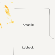
Hail Map for Monday, June 8, 2015

Number of Impacted Households on 6/8/2015
0
Impacted by 1" or Larger Hail
0
Impacted by 1.75" or Larger Hail
0
Impacted by 2.5" or Larger Hail
Square Miles of Populated Area Impacted on 6/8/2015
0
Impacted by 1" or Larger Hail
0
Impacted by 1.75" or Larger Hail
0
Impacted by 2.5" or Larger Hail


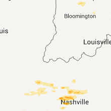


Cities Most Affected by Hail Storms of 6/8/2015
| Hail Size | Demographics of Zip Codes Affected | ||||||
|---|---|---|---|---|---|---|---|
| City | Count | Average | Largest | Pop Density | House Value | Income | Age |
| Sugar Grove, IL | 2 | 1.75 | 1.75 | 317 | $181k | $73.0k | 40.0 |
| Trevor, WI | 1 | 1.75 | 1.75 | 594 | $123k | $47.8k | 38.0 |
| Schererville, IN | 1 | 1.75 | 1.75 | 1766 | $160k | $60.0k | 41.9 |
| Hurricane Mills, TN | 1 | 1.75 | 1.75 | 8 | $75k | $45.2k | 46.3 |
| Quincy, IL | 1 | 1.75 | 1.75 | 2803 | $79k | $33.4k | 38.4 |
| Crescent City, IL | 1 | 1.75 | 1.75 | 16 | $85k | $39.0k | 43.7 |
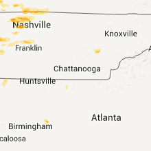
Hail and Wind Damage Spotted on 6/8/2015
Filter by Report Type:Hail ReportsWind Reports
States Impacted
Kentucky, Illinois, New York, Michigan, West Virginia, Tennessee, Pennsylvania, Virginia, Wisconsin, Mississippi, Alabama, Georgia, Indiana, New Mexico, Maryland, Missouri, North Carolina, OhioKentucky
| Local Time | Report Details |
|---|---|
| 7:00 AM CDT | Microburst began at intersection of i-24 and cox mill road and end 4.5 miles sw hopkinsville along cox mill road. max wind 85 mph with path length 2.5 miles. path width in christian county KY, 61.4 miles NW of Nashville, TN |
| 12:55 PM EDT | Multiple trees down northeast of blaine in lawrence county KY, 65.5 miles WSW of Charleston, WV |
| 1:00 PM EDT | 911 center reports trees down near the intersection of ced gap rd and ky 32. time estimated based on radar in lawrence county KY, 61.1 miles WSW of Charleston, WV |
| 1:00 PM EDT | Tree branches blown down between 2 and 3 inches in diamete in clay county KY, 40.2 miles SSE of Irvine, KY |
| 1:00 PM CDT | Quarter sized hail reported near Hardin, KY, 49.4 miles NNE of Mc Kenzie, TN, quarter size hail reported. |
| 2:01 PM EDT | A tree was blown dow in johnson county KY, 61.3 miles E of Irvine, KY |
| 1:02 PM CDT | Half Dollar sized hail reported near Franklin, KY, 37.2 miles NNE of Nashville, TN |
| 1:06 PM CDT | Ping Pong Ball sized hail reported near Franklin, KY, 36.2 miles NNE of Nashville, TN, reported at flying j truckstop exit 2... i-65 |
| 2:12 PM EDT | Large tree limbs blown down greater than 2 inches in diamte in floyd county KY, 64.4 miles E of Irvine, KY |
| 2:15 PM EDT | 6-8 inch tree limb broken. branch fell on power lin in floyd county KY, 66.1 miles E of Irvine, KY |
| 1:20 PM CDT | Half Dollar sized hail reported near Calvert City, KY, 62.6 miles N of Mc Kenzie, TN, local fire dept reported ground covered with quarter size to half dollar size hail. |
| 1:50 PM CDT | Widespread tree damage and power outages reported in the county. most tree damage along blue and gray park roa in todd county KY, 50.5 miles NNW of Nashville, TN |
| 1:50 PM CDT | Downed tree on a house in logan county KY, 46.8 miles NNW of Nashville, TN |
| 1:55 PM CDT | Tree on house and ca in logan county KY, 46.8 miles N of Nashville, TN |
| 1:55 PM CDT | Few downed trees reported near 2nd... 3rd... 4th... and 9th streets in russellvill in logan county KY, 47.4 miles N of Nashville, TN |
| 2:10 PM CDT | Downed trees along hwy 94e. trees damaged along poor farm road also. isolated power outages reported in rural areas of the count in calloway county KY, 37.2 miles NNE of Mc Kenzie, TN |
| 3:30 PM EDT | A tree was blown ove in knox county KY, 57.9 miles SSE of Irvine, KY |
| 4:12 PM EDT | Several trees down in mercer county KY, 43.7 miles W of Irvine, KY |
| 4:15 PM EDT | Two large limbs down in winding ridge subdivision. report relayed through social medi in pulaski county KY, 55.2 miles SW of Irvine, KY |
| 4:54 PM EDT | Tree down along howell drennon road west of mount sterlin in montgomery county KY, 25.1 miles N of Irvine, KY |
| 5:01 PM EDT | A tree was blown dow in johnson county KY, 61.3 miles E of Irvine, KY |
| 5:10 PM EDT | Several trees down in the northern part of the county in garrard county KY, 33.3 miles W of Irvine, KY |
| 5:45 PM EDT | Tree down on hollow poplar roa in morgan county KY, 46 miles ENE of Irvine, KY |
| 5:50 PM EDT | Tree down on branch street in west libert in morgan county KY, 41.2 miles ENE of Irvine, KY |
| 5:50 PM EDT | Tree and debris down on alec spencer drive in west libert in morgan county KY, 40.9 miles ENE of Irvine, KY |
| 5:56 PM EDT | Large tree limb and small debris down in west liberty. relayed through social medi in morgan county KY, 41.2 miles ENE of Irvine, KY |
| 6:26 PM EDT | Tree blown down in sitka on route 201 in johnson county KY, 62.7 miles ENE of Irvine, KY |
| 6:30 PM EDT | Tree blown down on route 203 in johnson county KY, 57.3 miles E of Irvine, KY |
Illinois
| Local Time | Report Details |
|---|---|
| 9:51 AM CDT | Large tree limbs/branches down... greater than 2 inches in tazewell county IL, 2.5 miles SE of Peoria, IL |
| 2:13 PM CDT | Ping Pong Ball sized hail reported near Zion, IL, 43.5 miles NNW of Chicago, IL, social media. |
| 2:20 PM CDT | Quarter sized hail reported near Waukegan, IL, 38.8 miles NNW of Chicago, IL, route 173 and green bay road. |
| 2:23 PM CDT | Quarter sized hail reported near Winthrop Harbor, IL, 42.4 miles NNW of Chicago, IL, 9th street and sheridan. |
| 2:30 PM CDT | Half Dollar sized hail reported near Zion, IL, 41.2 miles NNW of Chicago, IL, social media. |
| 2:38 PM CDT | Quarter sized hail reported near Lake Villa, IL, 43.5 miles NNW of Chicago, IL, deep lake road. |
| 2:50 PM CDT | Quarter sized hail reported near Ursa, IL, 30.5 miles SE of Kahoka, MO |
| 2:51 PM CDT | Quarter sized hail reported near Lake Villa, IL, 43.5 miles NNW of Chicago, IL, monaville road and route 59. |
| 2:54 PM CDT | Half Dollar sized hail reported near Zion, IL, 41.2 miles NNW of Chicago, IL, social media. |
| 2:55 PM CDT | Quarter sized hail reported near Spring Grove, IL, 46.5 miles NW of Chicago, IL, grant high school. |
| 2:55 PM CDT | Quarter sized hail reported near Quincy, IL, 31.6 miles SE of Kahoka, MO, relayed by wgem |
| 3:00 PM CDT | Quarter sized hail reported near Lake Villa, IL, 43.5 miles NNW of Chicago, IL, social media. |
| 3:06 PM CDT | Ping Pong Ball sized hail reported near Quincy, IL, 35 miles SE of Kahoka, MO |
| 3:08 PM CDT | Quarter sized hail reported near Quincy, IL, 38.1 miles SSE of Kahoka, MO, hail on east side of quincy illinois |
| 3:10 PM CDT | Golf Ball sized hail reported near Quincy, IL, 38.1 miles SSE of Kahoka, MO, hail at quincy illinois wal mart store |
| 4:03 PM CDT | Quarter sized hail reported near Bensenville, IL, 16.7 miles WNW of Chicago, IL, york and main. |
| 4:36 PM CDT | Golf Ball sized hail reported near Sugar Grove, IL, 43.4 miles W of Chicago, IL, at aurora airport. |
| 4:40 PM CDT | Golf Ball sized hail reported near Sugar Grove, IL, 43.4 miles W of Chicago, IL, social media. |
| 4:55 PM CDT | Ping Pong Ball sized hail reported near Carlock, IL, 25.3 miles ESE of Peoria, IL, via twitter |
| 4:55 PM CDT | Quarter sized hail reported near Carlock, IL, 23.5 miles ESE of Peoria, IL |
| 5:25 PM CDT | Quarter sized hail reported near Normal, IL, 34.4 miles ESE of Peoria, IL |
| 6:32 PM CDT | Quarter sized hail reported near Gilman, IL, 79.2 miles SSW of Chicago, IL |
| 6:36 PM CDT | Golf Ball sized hail reported near Crescent City, IL, 77.8 miles S of Chicago, IL, near 52nd and 24th south of crescent city. |
| 7:05 PM CDT | Quarter sized hail reported near Chenoa, IL, 45.7 miles E of Peoria, IL |
| 7:43 PM CDT | Medium sized tree limbs snapped off trees throughout town. also pea to dime sized hai in ford county IL, 65.4 miles ESE of Peoria, IL |
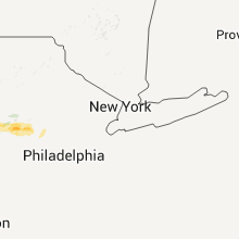
New York
| Local Time | Report Details |
|---|---|
| 11:51 AM EDT | Power lines down on adams roa in livingston county NY, 63.2 miles E of Buffalo, NY |
| 11:53 AM EDT | Large tree limbs down in the area of main street in livingston county NY, 64.3 miles E of Buffalo, NY |
| 12:10 PM EDT | Trees and wires down on honeoye road in ontario county NY, 58.5 miles W of Syracuse, NY |
| 12:30 PM EDT | Trees and wires down in livingston county NY, 64 miles ESE of Buffalo, NY |
| 12:30 PM EDT | Trees and wires down in livingston county NY, 59.1 miles ESE of Buffalo, NY |
| 12:45 PM EDT | Trees and wires down in seneca county NY, 37.6 miles WSW of Syracuse, NY |
| 12:50 PM EDT | Trees and wires down in seneca county NY, 34.5 miles WSW of Syracuse, NY |
| 12:54 PM EDT | Few trees down in cayuga county NY, 30.9 miles WSW of Syracuse, NY |
| 1:35 PM EDT | A few trees down and power out in tyrone in schuyler county NY, 64 miles SW of Syracuse, NY |
| 1:40 PM EDT | Trees down in onondaga county NY, 5.2 miles NW of Syracuse, NY |
| 2:00 PM EDT | Trees down on east shore drive near ithac in tompkins county NY, 45.8 miles SSW of Syracuse, NY |
| 2:15 PM EDT | Trees and wires down on honeoye road in ontario county NY, 58.5 miles W of Syracuse, NY |
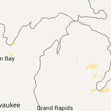
Michigan
| Local Time | Report Details |
|---|---|
| 12:44 PM EDT | Quarter sized hail reported near Kawkawlin, MI, 49.1 miles NNW of Flint, MI, relayed from dores party store |
| 12:44 PM EDT | Quarter sized hail reported near Kawkawlin, MI, 48.3 miles NNW of Flint, MI, relayed from mobile gas station |
| 12:46 PM EDT | Quarter sized hail reported near Kawkawlin, MI, 48.3 miles NNW of Flint, MI, relayed from st bartholomew lutheran school |
| 1:29 PM EDT | Quarter sized hail reported near Unionville, MI, 46.8 miles NNE of Flint, MI, relayed from the unionville post office |
| 2:33 PM EDT | Quarter sized hail reported near Deckerville, MI, 59.7 miles NE of Flint, MI |
| 5:05 PM EDT | Two 20" diameter trees downed in cambria township. no comments on health of tre in hillsdale county MI, 58.5 miles NNE of Fort Wayne, IN |
| 5:05 PM EDT | Storm damage reported in hillsdale county MI, 64.8 miles NNE of Fort Wayne, IN |
| 5:08 PM EDT | Three 13 inch diameter limbs downed in adams township (estimated diameter in hillsdale county MI, 66.2 miles NNE of Fort Wayne, IN |
| 5:55 PM EDT | Several large trees uprooted along river stree in iosco county MI, 54 miles S of Alpena, MI |
West Virginia
| Local Time | Report Details |
|---|---|
| 1:40 PM EDT | 911 center reports large tree down across rt 10 near midkiff. time estimated based on rada in lincoln county WV, 31.7 miles WSW of Charleston, WV |
| 2:21 PM EDT | 1 tree down. time estimated by radar in preston county WV, 39.7 miles N of Elkins, WV |
| 2:30 PM EDT | Power poles down in the ferrellsburg area. time estimated from rada in lincoln county WV, 34.3 miles SW of Charleston, WV |
| 2:50 PM EDT | Trees reported down in the town of delbarton. time estimated from rada in mingo county WV, 54 miles SW of Charleston, WV |
| 3:40 PM EDT | Trees down in the wharton area. time estimated from rada in boone county WV, 31.1 miles S of Charleston, WV |
| 3:50 PM EDT | Trees down in the whitesville area. time estimated from rada in boone county WV, 26.1 miles SSE of Charleston, WV |
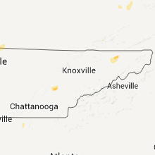
Tennessee
| Local Time | Report Details |
|---|---|
| 1:04 PM CDT | Quarter sized hail reported near Clarksville, TN, 38.1 miles NW of Nashville, TN, quarter size hail in clarksville off of i-24 at exit 11. |
| 1:06 PM CDT | Half Dollar sized hail reported near Portland, TN, 34.5 miles NNE of Nashville, TN, half dollar size hail on the ky/tn state line. |
| 1:33 PM CDT | Quarter sized hail reported near Springfield, TN, 23.6 miles NNW of Nashville, TN, nickel to quarter size hail |
| 1:42 PM CDT | Quarter sized hail reported near Springfield, TN, 21.1 miles N of Nashville, TN |
| 1:51 PM CDT | Trees down at kinneys road and old washington road in robertson county TN, 29.1 miles NNW of Nashville, TN |
| 1:52 PM CDT | Trees down at kinneys road and calvary church road in robertson county TN, 29.1 miles NNW of Nashville, TN |
| 2:00 PM CDT | Quarter sized hail reported near Springfield, TN, 24.2 miles NNW of Nashville, TN, nssl shave report |
| 2:00 PM CDT | Quarter sized hail reported near Springfield, TN, 24 miles NNW of Nashville, TN, nssl shave report |
| 2:00 PM CDT | Ping Pong Ball sized hail reported near Springfield, TN, 24.7 miles NNW of Nashville, TN, nssl shave report |
| 2:00 PM CDT | Quarter sized hail reported near Portland, TN, 27.1 miles NE of Nashville, TN, nssl shave report |
| 2:10 PM CDT | Half Dollar sized hail reported near Buena Vista, TN, 17.5 miles SE of Mc Kenzie, TN, large hail reported. |
| 2:10 PM CDT | Quarter sized hail reported near Springfield, TN, 24 miles NNW of Nashville, TN, nssl shave report |
| 2:15 PM CDT | Large trees down blocking highway 79 around the forked deer river bridge near bell in crockett county TN, 42.8 miles SW of Mc Kenzie, TN |
| 2:20 PM CDT | Trees down and houses damaged along highway 412 near bell in crockett county TN, 42.8 miles SW of Mc Kenzie, TN |
| 2:20 PM CDT | Tops of trees snapped. mail boxes damaged around the gibson high school area and around 130 trenton highwa in gibson county TN, 26.7 miles W of Mc Kenzie, TN |
| 2:48 PM CDT | Ping Pong Ball sized hail reported near Ashland City, TN, 17.5 miles WNW of Nashville, TN, at least ping pong size hail falling in ashland city |
| 3:00 PM CDT | Ping Pong Ball sized hail reported near Springfield, TN, 24.7 miles NNW of Nashville, TN, nssl shave report |
| 3:00 PM CDT | Quarter sized hail reported near New Johnsonville, TN, 32.3 miles ESE of Mc Kenzie, TN, nssl shave report |
| 3:00 PM CDT | Quarter sized hail reported near New Johnsonville, TN, 33.5 miles ESE of Mc Kenzie, TN, nssl shave report |
| 3:07 PM CDT | Quarter sized hail reported near New Johnsonville, TN, 32.6 miles ESE of Mc Kenzie, TN, nssl shave report |
| 3:15 PM CDT | Quarter sized hail reported near New Johnsonville, TN, 32.6 miles ESE of Mc Kenzie, TN, nssl shave report |
| 3:15 PM CDT | Golf Ball sized hail reported near Hurricane Mills, TN, 46.7 miles ESE of Mc Kenzie, TN, nssl shave report |
| 3:23 PM CDT | Ping Pong Ball sized hail reported near Hurricane Mills, TN, 41.8 miles ESE of Mc Kenzie, TN, nssl shave report |
| 3:25 PM CDT | Quarter sized hail reported near Hurricane Mills, TN, 44.4 miles ESE of Mc Kenzie, TN, nssl shave report |
| 4:30 PM EDT | Couple trees dow in roane county TN, 33.6 miles W of Knoxville, TN |
| 3:31 PM CDT | Power outages in the same area too in dickson county TN, 38.8 miles WSW of Nashville, TN |
| 4:40 PM EDT | Couple trees dow in union county TN, 20.9 miles NNE of Knoxville, TN |
| 4:50 PM EDT | Couple trees dow in loudon county TN, 33.1 miles SW of Knoxville, TN |
| 5:00 PM EDT | One tree and several large tree limbs down in the brainerd are in hamilton county TN, 7.2 miles ESE of Chattanooga, TN |
| 4:00 PM CDT | Trees down at mill creek ln and highway 100 near wrigle in hickman county TN, 37.3 miles WSW of Nashville, TN |
| 4:13 PM CDT | Shingles off roo in chester county TN, 48 miles S of Mc Kenzie, TN |
| 5:15 PM EDT | Trees and power lines as well as at least 5 homes damage in hamilton county TN, 7.2 miles ESE of Chattanooga, TN |
| 4:18 PM CDT | Several trees down and power lines down around jackso in madison county TN, 38.8 miles SSW of Mc Kenzie, TN |
| 5:20 PM EDT | Several trees dow in mcminn county TN, 50.1 miles SW of Knoxville, TN |
| 4:20 PM CDT | Several large trees...tree limbs...and power lines down across madison county tennesse in madison county TN, 38.8 miles SSW of Mc Kenzie, TN |
| 4:24 PM CDT | Quarter sized hail reported near Franklin, TN, 16.8 miles SSW of Nashville, TN |
| 4:27 PM CDT | Half Dollar sized hail reported near Franklin, TN, 16.8 miles SSW of Nashville, TN |
| 5:30 PM EDT | Numerous trees down in the corryton are in knox county TN, 14.7 miles NNE of Knoxville, TN |
| 4:35 PM CDT | Trees being cleared from along parker branch/patterson/and highway 9 in williamson county TN, 18.5 miles S of Nashville, TN |
| 5:45 PM EDT | Tree dow in sullivan county TN, 17.8 miles WSW of Bristol, TN |
| 5:53 PM EDT | Storm damage reported in sullivan county TN, 7.4 miles SW of Bristol, TN |
| 6:20 PM EDT | Couple trees and a few limbs down near volunteer parkway a mile south of the bristol motor speedwa in sullivan county TN, 6 miles SSW of Bristol, TN |
| 7:00 PM EDT | Trees down county-wid in hamilton county TN, 3.2 miles ENE of Chattanooga, TN |
| 7:20 PM EDT | Trees down county-wid in bradley county TN, 26.5 miles ENE of Chattanooga, TN |
| 7:20 PM EDT | Several trees down in the northwestern portions of the county from chilhowee to relianc in polk county TN, 43 miles ENE of Chattanooga, TN |
| 8:00 PM EDT | Several trees down in the northern portion of the count in rhea county TN, 53.8 miles WSW of Knoxville, TN |
| 8:30 PM EDT | Tree down on house on stockton valley r in loudon county TN, 29 miles WSW of Knoxville, TN |
| 8:30 PM EDT | Tree down at the intersection of fish hatchery rd and hwy 1 in monroe county TN, 39.6 miles SW of Knoxville, TN |
| 8:20 PM CDT | Drain gutter ripped off of home in arlingto in shelby county TN, 23.8 miles ENE of Memphis, TN |
Pennsylvania
| Local Time | Report Details |
|---|---|
| 2:07 PM EDT | Quarter sized hail reported near Mc Clure, PA, 29.5 miles E of State College, PA, nickel to quarter size hail |
| 3:00 PM EDT | 2 large trees down/road closure in jackson twp in northumberland county PA, 53.9 miles E of State College, PA |
| 3:05 PM EDT | Trees down on johnstown road in blair county PA, 42.3 miles SW of State College, PA |
| 3:10 PM EDT | Trees and wires down on route 333 at tuscarora road in turbett township in mckean county PA, 71.8 miles NNW of State College, PA |
| 3:10 PM EDT | Trees and wires down on route 333 at tuscarora road in turbett township in juniata county PA, 32 miles SE of State College, PA |
| 3:15 PM EDT | Multiple trees and wires down on doe run road in juniata county PA, 32 miles ESE of State College, PA |
| 3:40 PM EDT | Damage to house and several outbuildings on state route 12 in northumberland county PA, 65 miles SW of Scranton, PA |
| 3:50 PM EDT | Tree down on rte 322 blocking right lane and berm in perry county PA, 39.7 miles ESE of State College, PA |
| 3:50 PM EDT | Trees down in perry county PA, 36.3 miles SSE of State College, PA |
| 4:00 PM EDT | Tree damage large limbs down on rte 26 in huntingdon county PA, 15.3 miles SSW of State College, PA |
| 4:05 PM EDT | Trees down in perry county PA, 42.7 miles SE of State College, PA |
| 4:05 PM EDT | Trees down in perry county PA, 39.9 miles SE of State College, PA |
| 4:30 PM EDT | Trees and wires down in 1000 block of harrisburg pike partially blocking roa in cumberland county PA, 54.3 miles SE of State College, PA |
| 4:40 PM EDT | Trees down in dauphin county PA, 53.8 miles ESE of State College, PA |
| 4:45 PM EDT | Trees down in schuylkill county PA, 70.5 miles SSW of Scranton, PA |
| 4:50 PM EDT | Numerous trees down in columbia county PA, 37.8 miles WSW of Scranton, PA |
| 4:50 PM EDT | Trees down in lycoming county PA, 54.1 miles NE of State College, PA |
| 4:55 PM EDT | Trees down on route 42 and beaver lake road in davidson township in sullivan county PA, 47.7 miles W of Scranton, PA |
| 5:00 PM EDT | Trees down in dauphin county PA, 63.1 miles ESE of State College, PA |
| 5:15 PM EDT | Quarter sized hail reported near Schuylkill Haven, PA, 64.3 miles SSW of Scranton, PA |
| 5:15 PM EDT | Trees down in lebanon county PA, 72.1 miles ESE of State College, PA |
| 5:40 PM EDT | Tree limbs and wires down in several locations in berks county... especially the northern hal in berks county PA, 61 miles SSW of Scranton, PA |
| 5:43 PM EDT | Trees down in cumberland county PA, 61.8 miles SE of State College, PA |
| 5:58 PM EDT | Trees/wires down in york county PA, 60.1 miles NNW of Baltimore, MD |
| 6:05 PM EDT | Trees down in dauphin county PA, 66.4 miles SE of State College, PA |
| 6:05 PM EDT | Storm damage reported in berks county PA, 62.8 miles S of Scranton, PA |
| 6:05 PM EDT | Poles and wires down in berks county PA, 62.1 miles S of Scranton, PA |
| 6:07 PM EDT | Storm damage reported in berks county PA, 62.1 miles S of Scranton, PA |
| 6:15 PM EDT | Trees down in dauphin county PA, 60.8 miles N of Baltimore, MD |
| 6:20 PM EDT | Numerous trees and wires down in alburtis and macungie. some roads closed. 1606 customers without power in lower macgungie township. initial report relayed by epaw in lehigh county PA, 62.2 miles S of Scranton, PA |
| 6:40 PM EDT | Wires down/tree on home in adams county PA, 40.3 miles NW of Baltimore, MD |
Virginia
| Local Time | Report Details |
|---|---|
| 2:42 PM EDT | One tree down on bleak hill lan in franklin county VA, 21.5 miles SSW of Roanoke, VA |
| 2:48 PM EDT | Trees and power lines down on court stree in shenandoah county VA, 72 miles E of Elkins, WV |
| 3:33 PM EDT | 2 trees down along hardy rd in franklin county VA, 13.4 miles SE of Roanoke, VA |
| 3:35 PM EDT | One tree down on bleak hill lan in franklin county VA, 21.5 miles SSW of Roanoke, VA |
| 4:36 PM EDT | Midland trail rd just west of beatty hallow is closed due to a fallen large tree and powerlin in rockbridge county VA, 45.2 miles NE of Roanoke, VA |
| 4:39 PM EDT | One tree down in 800 block of indian valley post office road in floyd county VA, 43.2 miles SW of Roanoke, VA |
| 4:42 PM EDT | Two trees down near intersection of indian valley road and camp five roa in floyd county VA, 42.7 miles SW of Roanoke, VA |
| 5:40 PM EDT | Couple trees dow in scott county VA, 20.2 miles W of Bristol, TN |
| 5:55 PM EDT | Several trees down in the northern end of the county and a tree down on house on franks hollow road in the swords creek are in russell county VA, 39.6 miles NNE of Bristol, TN |
| 6:24 PM EDT | Trees down near intersection of stonewall jackson highway and browntown roa in warren county VA, 88.6 miles E of Elkins, WV |
| 6:33 PM EDT | Tree down across highway 11 approximately 1/2 mile south of tow in shenandoah county VA, 69.1 miles E of Elkins, WV |
| 6:50 PM EDT | Several trees down in the eastern portion of the count in washington county VA, 24.1 miles E of Bristol, TN |
| 7:01 PM EDT | 1 tree down forcing a temporary road closure along stoney battery r in smyth county VA, 38.1 miles ENE of Bristol, TN |
| 7:03 PM EDT | 1 tree down along flat ridge rd in sugar grove causing a temporary road closur in smyth county VA, 47.2 miles ENE of Bristol, TN |
| 7:03 PM EDT | Multiple trees down leading to temporary road closures along spring hallow r in smyth county VA, 38.5 miles ENE of Bristol, TN |
| 7:03 PM EDT | 1 tree down along nicks creek rd in smyth county VA, 47.4 miles ENE of Bristol, TN |
| 7:06 PM EDT | 1 tree down along flat ridge rd in sugar grove causing a temporary road closur in smyth county VA, 47.2 miles ENE of Bristol, TN |
| 7:15 PM EDT | Very large tree down. estimated 70 mph wind in fairfax county VA, 48.4 miles WSW of Baltimore, MD |
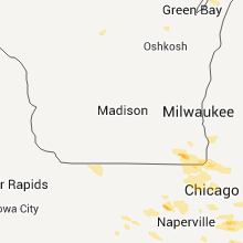
Wisconsin
| Local Time | Report Details |
|---|---|
| 1:48 PM CDT | Quarter sized hail reported near Silver Lake, WI, 53.6 miles NNW of Chicago, IL |
| 1:50 PM CDT | Half Dollar sized hail reported near Salem, WI, 52.1 miles NNW of Chicago, IL, estimated size. relayed via facebook. |
| 1:50 PM CDT | Quarter sized hail reported near Trevor, WI, 49.9 miles NNW of Chicago, IL, time estimated based on radar. |
| 1:53 PM CDT | Golf Ball sized hail reported near Trevor, WI, 49.8 miles NNW of Chicago, IL, report from spring valley country club. lots of hail with the largest ones the size of golf balls. |
| 3:30 PM CDT | Three 8 inch diameter trees and a few powerlines down on the north side of appleto in outagamie county WI, 26 miles SW of Green Bay, WI |
| 3:58 PM CDT | Electrical line shorted out causing smoke/line to burn and drop from the pole. small twigs/branches also down. wind speed unknown. delayed report. time estimate in calumet county WI, 34.2 miles SSW of Green Bay, WI |
Mississippi
| Local Time | Report Details |
|---|---|
| 2:05 PM CDT | 2 large trees down on houses in potts camp are in marshall county MS, 54.3 miles SE of Memphis, TN |
| 10:40 PM CDT | Trees down and flooding along highway 15 in riple in tippah county MS, 69.3 miles ESE of Memphis, TN |
| 10:45 PM CDT | Trees down along with power outages reported in martintow in union county MS, 70 miles NNW of Starkville, MS |
| 11:26 PM CDT | Trees dow in marshall county MS, 32.1 miles SE of Memphis, TN |
| 11:55 PM CDT | Trees down throughout union county...including new alban in union county MS, 71.6 miles N of Starkville, MS |
| 12:25 AM CDT | Trees down on jaggers road near the pontotoc parkway. a roof was lifted off a trailer on kings highwa in pontotoc county MS, 52.8 miles N of Starkville, MS |
| 3:20 AM CDT | Multiple trees and power lines downed. a tree fell on a house. a horse barn was damaged at the coliseum. small hail also reporte in leake county MS, 48.7 miles NE of Jackson, MS |
Alabama
| Local Time | Report Details |
|---|---|
| 2:45 PM CDT | Power lines down at hermitage dr and royal ave. time estimated from rada in lauderdale county AL, 0.7 miles NNE of Florence, AL |
| 2:56 PM CDT | Trees reported down on cr 311 in lauderdale county AL, 8.5 miles NNE of Florence, AL |
| 3:24 PM CDT | Trees down...a few on houses along highway 69 between simcoe and baileyton. some power lines downe in cullman county AL, 50.8 miles N of Birmingham, AL |
| 4:14 PM CDT | Winds estimated to around 55 mph. trees down near the intersection of highway 231 and cathedral caverns highwa in marshall county AL, 68.4 miles SW of Chattanooga, TN |
| 4:14 PM CDT | Quarter sized hail reported near Grant, AL, 68.4 miles SW of Chattanooga, TN, nickel to quarter sized hail reported |
| 4:41 PM CDT | Trees down in the grove oak community. time estimated by rada in dekalb county AL, 59.4 miles SW of Chattanooga, TN |
| 5:14 PM CDT | Trees knocked down in the ider area. time estimated by rada in dekalb county AL, 31.5 miles SW of Chattanooga, TN |
| 5:22 PM CDT | An external tin roof on an apartment complex was torn off at 4952 hwy 75. trees and powerline down in the area as wel in dekalb county AL, 25.7 miles SW of Chattanooga, TN |
| 5:23 PM CDT | Trees knocked down in the mentone area. time estimated by rada in dekalb county AL, 35.9 miles SSW of Chattanooga, TN |
Georgia
| Local Time | Report Details |
|---|---|
| 4:50 PM EDT | Trees down on 6 homes in lakeview. powerlines down als in catoosa county GA, 5.4 miles SSE of Chattanooga, TN |
| 6:43 PM EDT | 911 center reported one tree down on a house near lookout mountai in walker county GA, 10.5 miles SSW of Chattanooga, TN |
| 6:55 PM EDT | 911 center reported approximately 30 trees down in the rossville are in walker county GA, 4.7 miles SSE of Chattanooga, TN |
| 7:00 PM EDT | Amateur radio operator reported a 62 mph recorded gust at battlefield parkway and fant driv in catoosa county GA, 7.7 miles SSE of Chattanooga, TN |
| 8:30 PM EDT | 911 center reported one tree down on lewis street in summervill in chattooga county GA, 39.1 miles S of Chattanooga, TN |
| 8:33 PM EDT | One tree down at the intersection of neely road and reed road in whitfield county GA, 24.8 miles SE of Chattanooga, TN |
| 8:36 PM EDT | 911 center reported one tree down on ridgeway drive and henderson roa in chattooga county GA, 32.2 miles S of Chattanooga, TN |
| 8:36 PM EDT | 911 center reported one tree down on center post road and cummings roa in chattooga county GA, 32.9 miles S of Chattanooga, TN |
| 4:20 AM EDT | The cherokee county emergency manager reported trees...power lines and power poles down and blocking new light roa in cherokee county GA, 30.2 miles N of Atlanta, GA |
Indiana
| Local Time | Report Details |
|---|---|
| 4:55 PM EDT | Quarter sized hail reported near New Carlisle, IN, 60.9 miles ESE of Chicago, IL |
| 4:24 PM CDT | Quarter sized hail reported near Schererville, IN, 28.8 miles SSE of Chicago, IL, 50 mph winds also reported. |
| 4:26 PM CDT | Golf Ball sized hail reported near Schererville, IN, 28.8 miles SSE of Chicago, IL, damage to vehicles reported. |
| 5:30 PM EDT | 1 ft diameter tree down. looks partially rotted from pictures... hard to tell. time estimated by rada in st. joseph county IN, 70.9 miles NW of Fort Wayne, IN |
| 4:35 PM CDT | Quarter sized hail reported near Griffith, IN, 27.4 miles SSE of Chicago, IL, social media. |
| 4:35 PM CDT | Quarter sized hail reported near Westville, IN, 44.3 miles ESE of Chicago, IL |
| 4:50 PM CDT | Quarter sized hail reported near Union Mills, IN, 51.8 miles ESE of Chicago, IL |
| 5:00 PM CDT | Half Dollar sized hail reported near Hobart, IN, 30.8 miles SE of Chicago, IL, social media. |
| 5:03 PM CDT | Quarter sized hail reported near Crown Point, IN, 35 miles SSE of Chicago, IL, 1 mile east 90001 e lincoln hwy. |
| 6:05 PM EDT | Quarter sized hail reported near Lakeville, IN, 68.2 miles WNW of Fort Wayne, IN |
| 6:15 PM EDT | Reports of tree down on a power line on the 300 block of south witloc in marshall county IN, 60.2 miles WNW of Fort Wayne, IN |
| 5:20 PM CDT | Ping Pong Ball sized hail reported near San Pierre, IN, 61.8 miles SE of Chicago, IL |
| 5:49 PM CDT | Quarter sized hail reported near Crown Point, IN, 35 miles SSE of Chicago, IL, 1 mile east 90001 e lincoln hwy. |
| 6:51 PM EDT | Trees and limbs down in broken arrow campground in pulaski county IN, 75.8 miles SE of Chicago, IL |
| 6:07 PM CDT | Half Dollar sized hail reported near Demotte, IN, 53.3 miles SSE of Chicago, IL |
| 6:45 PM CDT | Half Dollar sized hail reported near Rensselaer, IN, 69.2 miles SSE of Chicago, IL |
| 7:02 PM CDT | Quarter sized hail reported near Goodland, IN, 79.6 miles SSE of Chicago, IL |
| 8:08 PM EDT | Report of two trees down due to winds... reported by hoagland fd... relayed via media in allen county IN, 10.4 miles SSE of Fort Wayne, IN |
| 7:08 PM CDT | Branches dow in jasper county IN, 81.5 miles SSE of Chicago, IL |
| 8:15 PM EDT | Storm damage reported in white county IN, 83.1 miles NW of Indianapolis, IN |
| 9:00 PM EDT | One tree down...several large limbs down...a truck was severly damaged by a large branch in grant county IN, 51 miles SSW of Fort Wayne, IN |
| 9:33 PM EDT | Trees and power poles down. similar damage near anderson and lape in madison county IN, 37.8 miles NNE of Indianapolis, IN |
| 9:53 PM EDT | Quarter sized hail reported near Avon, IN, 12.3 miles W of Indianapolis, IN |
New Mexico
| Local Time | Report Details |
|---|---|
| 2:57 PM MDT | Quarter sized hail reported near Wagon Mound, NM, 55 miles ESE of Taos, NM, penny to quarter sized hail accumulated up to a foot deep |
| 4:10 PM MDT | Quarter sized hail reported near Des Moines, NM, 99.9 miles ENE of Taos, NM |
| 4:30 PM MDT | Ping Pong Ball sized hail reported near Des Moines, NM, 99.9 miles ENE of Taos, NM |
| 4:36 PM MDT | Quarter sized hail reported near Des Moines, NM, 99.4 miles ENE of Taos, NM, accumulated to a depth of 2 inches |
| 5:19 PM MDT | Quarter sized hail reported near Grenville, NM, 97.5 miles N of Tucumcari, NM |
| 6:38 PM MDT | Quarter sized hail reported near Grenville, NM, 77.3 miles N of Tucumcari, NM |
| 6:38 PM MDT | 4 inch diameter live tree limbs snappe in union county NM, 77.3 miles N of Tucumcari, NM |
| 6:51 PM MDT | Ping Pong Ball sized hail reported near Grenville, NM, 77.4 miles N of Tucumcari, NM |
Maryland
| Local Time | Report Details |
|---|---|
| 6:28 PM EDT | Storm damage reported in frederick county MD, 41.7 miles WNW of Baltimore, MD |
| 6:43 PM EDT | Outbuilding destroyed in frederick county MD, 37 miles WNW of Baltimore, MD |
| 7:34 PM EDT | Tree down near intersection of western run road and shawan roa in baltimore county MD, 14.8 miles NNW of Baltimore, MD |
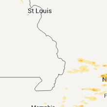
Missouri
| Local Time | Report Details |
|---|---|
| 6:01 PM CDT | Quarter sized hail reported near Vandalia, MO, 51.6 miles ENE of Columbia, MO |
| 6:01 PM CDT | Wind was strong enough to push two cars into each other. public report relayed via krc in audrain county MO, 51.6 miles ENE of Columbia, MO |
North Carolina
| Local Time | Report Details |
|---|---|
| 7:03 PM EDT | 1 tree down along nicks creek rd in ashe county NC, 47.9 miles ESE of Bristol, TN |
| 7:30 PM EDT | Emergency manager reported multiple trees uprooted... windows blown out of structures... and structures with roof damage. time estimated from rada in mcdowell county NC, 63.8 miles WNW of Charlotte, NC |
| 7:52 PM EDT | Tree down in glenwood area near hwy 221 and mud cut rd in mcdowell county NC, 64.2 miles NNE of Greenville, SC |
| 8:30 PM EDT | Few trees dow in cherokee county NC, 60.3 miles S of Knoxville, TN |
| 8:40 PM EDT | Few trees dow in cherokee county NC, 52.7 miles S of Knoxville, TN |
| 9:00 PM EDT | One tree dow in clay county NC, 61.1 miles WNW of Greenville, SC |
| 9:40 PM EDT | Multiple trees down in macon county NC, 37.2 miles WNW of Greenville, SC |
| 10:25 PM EDT | Power lines and few trees down in cedar mountain in transylvania county NC, 21.4 miles N of Greenville, SC |
| 10:25 PM EDT | Tree down in little river in transylvania county NC, 28.3 miles N of Greenville, SC |
Ohio
| Local Time | Report Details |
|---|---|
| 7:35 PM EDT | Report of tree down over powerlines. also 0.5 inch hail nearb in henry county OH, 55.2 miles ENE of Fort Wayne, IN |
| 7:40 PM EDT | 1 inch diameter limb down... power line down... 2 traffic lights ou in williams county OH, 39.5 miles NE of Fort Wayne, IN |
| 8:00 PM EDT | Power line down at cr l... sr 109 in henry county OH, 57.7 miles ENE of Fort Wayne, IN |
| 10:19 PM EDT | Half of a metal roof from a barn was peeled back along with an upstairs window blown ou in champaign county OH, 33.8 miles WNW of Columbus, OH |
| 10:20 PM EDT | *** 2 inj *** large tree into a house. time estimated from rada in montgomery county OH, 49.1 miles NNE of Cincinnati, OH |
Connect with Interactive Hail Maps