

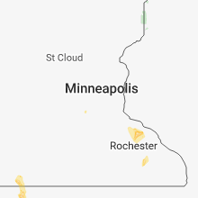
Hail Map for Friday, June 8, 2018

Number of Impacted Households on 6/8/2018
0
Impacted by 1" or Larger Hail
0
Impacted by 1.75" or Larger Hail
0
Impacted by 2.5" or Larger Hail
Square Miles of Populated Area Impacted on 6/8/2018
0
Impacted by 1" or Larger Hail
0
Impacted by 1.75" or Larger Hail
0
Impacted by 2.5" or Larger Hail


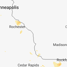


Cities Most Affected by Hail Storms of 6/8/2018
| Hail Size | Demographics of Zip Codes Affected | ||||||
|---|---|---|---|---|---|---|---|
| City | Count | Average | Largest | Pop Density | House Value | Income | Age |
| Rapid City, SD | 6 | 2.21 | 2.75 | 111 | $119k | $47.4k | 44.3 |
| Cody, NE | 3 | 1.83 | 2.00 | 0 | $34k | $26.7k | 41.3 |
| Elwood, IN | 3 | 1.75 | 1.75 | 157 | $68k | $33.2k | 41.2 |
| Kindred, ND | 2 | 1.88 | 2.00 | 12 | $79k | $48.2k | 38.8 |
| Hobbs, NM | 2 | 1.88 | 2.00 | 60 | $51k | $28.1k | 30.9 |
| Piedmont, SD | 1 | 2.50 | 2.50 | 23 | $88k | $41.5k | 41.4 |
| Wanblee, SD | 1 | 2.00 | 2.00 | 1 | $62k | $13.8k | 22.5 |
| Keystone, SD | 1 | 1.75 | 1.75 | 9 | $97k | $31.4k | 50.6 |
| Gordon, NE | 1 | 1.75 | 1.75 | 2 | $46k | $28.0k | 45.1 |
| Long Valley, SD | 1 | 1.75 | 1.75 | 0 | $30k | $23.8k | 44.5 |
| Flippin, AR | 1 | 1.75 | 1.75 | 26 | $73k | $27.9k | 48.4 |
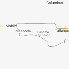
Hail and Wind Damage Spotted on 6/8/2018
Filter by Report Type:Hail ReportsWind Reports
States Impacted
Ohio, Louisiana, Florida, South Dakota, Georgia, Arkansas, Mississippi, North Dakota, Minnesota, Indiana, Virginia, Iowa, Missouri, Colorado, Wyoming, Arizona, Nebraska, New Mexico, Texas, KansasOhio
| Local Time | Report Details |
|---|---|
| 1:01 PM EDT | Tree down on house along rumsey road. time estimated from rada in franklin county OH, 5.1 miles SSE of Columbus, OH |
| 1:06 PM EDT | Tree down on power line on williams road. time estimated by rada in franklin county OH, 5.3 miles SSE of Columbus, OH |
| 1:15 PM EDT | Three large power poles down along obetz road between lockbourne and parsons ave. time estimate in franklin county OH, 5.8 miles SSE of Columbus, OH |
| 1:50 PM EDT | Multiple trees reported down throughout county. time estimated from rada in pickaway county OH, 25.1 miles S of Columbus, OH |
| 2:48 PM EDT | Power poles leaning. road not closed. reported at 6135 independence rd. defianc in defiance county OH, 46.2 miles ENE of Fort Wayne, IN |
| 2:48 PM EDT | Power poles reported down and banner school road is closed between adams ridge rd and independence roa in defiance county OH, 46.5 miles ENE of Fort Wayne, IN |
| 4:48 PM EDT | Three trees down on a roa in richland county OH, 59.5 miles NNE of Columbus, OH |
| 5:54 PM EDT | Tree reportedly fell on a vehicle near s.r. 73 and s.r. 123 in franklin... ohio. time estimated from rada in warren county OH, 33.1 miles NNE of Cincinnati, OH |
| 5:55 PM EDT | Large limbs down on route 123 in franklin... ohio. time estimated by rada in warren county OH, 33.1 miles NNE of Cincinnati, OH |
| 6:54 PM EDT | A couple of trees were knocked down on colerain ave... between kemper rd. and struble r in hamilton county OH, 13.2 miles NNW of Cincinnati, OH |
Louisiana
| Local Time | Report Details |
|---|---|
| 2:19 PM CDT | Local media reported damage to seating a covering/pavillion at the baby cakes baseball field. the covering also blew into a powerline and called damag in jefferson county LA, 6.9 miles WNW of New Orleans, LA |
| 5:59 PM CDT | Metal roof peeled off a building and a few trees uprooted. possible tornad in st. helena county LA, 67.7 miles NW of New Orleans, LA |
Florida
| Local Time | Report Details |
|---|---|
| 3:45 PM EDT | A tree fell on power lines at mile marker 432 on i-7 in columbia county FL, 64 miles W of Jacksonville, FL |
| 5:54 PM EDT | A few trees down at mile marker 237 and 239 on i-1 in madison county FL, 33.5 miles E of Tallahassee, FL |
| 6:30 PM EDT | Us air force wind tower 509 measured a peak wind gust of 51 knots from the west-southwes in brevard county FL, 43 miles E of Orlando, FL |
| 6:48 PM EDT | Awos at patrick air force base measured a peak wind gust of 54 knots / 62 mph from the wes in brevard county FL, 51 miles ESE of Orlando, FL |
| 6:50 PM EDT | Us air force wind tower 311 measured a peak wind gust of 51 knots from the west-southwes in brevard county FL, 45 miles E of Orlando, FL |
| 6:50 PM EDT | Us air force wind tower 211 measured a peak wind gust of 56 knots from the west-southwes in brevard county FL, 46.3 miles E of Orlando, FL |
| 6:56 PM EDT | Tree reported down on meridian between ox bottom rd and rose hil in leon county FL, 7.6 miles N of Tallahassee, FL |
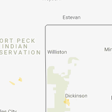
South Dakota
| Local Time | Report Details |
|---|---|
| 2:15 PM MDT | Quarter sized hail reported near , , 19 miles WNW of Rapid City, SD |
| 2:18 PM MDT | Ping Pong Ball sized hail reported near Piedmont, SD, 13.8 miles NW of Rapid City, SD |
| 2:20 PM MDT | Tennis Ball sized hail reported near Piedmont, SD, 13 miles NNW of Rapid City, SD, time estimated based on radar. |
| 2:33 PM MDT | Half Dollar sized hail reported near Nemo, SD, 15.6 miles WNW of Rapid City, SD |
| 2:35 PM MDT | Tennis Ball sized hail reported near Rapid City, SD, 10.5 miles WNW of Rapid City, SD |
| 2:48 PM MDT | Baseball sized hail reported near Rapid City, SD, 10.9 miles WNW of Rapid City, SD |
| 3:01 PM MDT | Hen Egg sized hail reported near Rapid City, SD, 9.5 miles W of Rapid City, SD |
| 3:07 PM MDT | Hen Egg sized hail reported near Rapid City, SD, 8.5 miles W of Rapid City, SD |
| 3:10 PM MDT | Quarter sized hail reported near Rapid City, SD, 4.2 miles NW of Rapid City, SD |
| 3:27 PM MDT | Quarter sized hail reported near Rapid City, SD, 6.8 miles SW of Rapid City, SD |
| 3:28 PM MDT | Ping Pong Ball sized hail reported near Rapid City, SD, 6.8 miles SW of Rapid City, SD |
| 3:32 PM MDT | Hen Egg sized hail reported near Rapid City, SD, 7.8 miles SSW of Rapid City, SD, hail fell at bear country. |
| 3:45 PM MDT | Half Dollar sized hail reported near Rapid City, SD, 7.3 miles SSW of Rapid City, SD |
| 3:45 PM MDT | Hen Egg sized hail reported near Rapid City, SD, 7.1 miles SSW of Rapid City, SD |
| 3:55 PM MDT | Ping Pong Ball sized hail reported near Rapid City, SD, 11.5 miles SSW of Rapid City, SD |
| 4:00 PM MDT | Quarter sized hail reported near Wanblee, SD, 74.8 miles NW of Valentine, NE |
| 4:00 PM MDT | Quarter sized hail reported near Wanblee, SD, 75.1 miles ESE of Rapid City, SD |
| 4:03 PM MDT | Hen Egg sized hail reported near Wanblee, SD, 75.1 miles ESE of Rapid City, SD |
| 4:11 PM MDT | Golf Ball sized hail reported near Keystone, SD, 15.4 miles SSW of Rapid City, SD |
| 4:15 PM MDT | Half Dollar sized hail reported near Hermosa, SD, 16.2 miles S of Rapid City, SD |
| 4:25 PM MDT | Quarter sized hail reported near Sturgis, SD, 26.6 miles NNW of Rapid City, SD |
| 4:40 PM MDT | Storm damage reported in jackson county SD, 69.1 miles NW of Valentine, NE |
| 5:18 PM MDT | Golf Ball sized hail reported near Long Valley, SD, 60.5 miles NW of Valentine, NE |
| 5:23 PM MDT | Storm damage reported in jackson county SD, 69.1 miles NW of Valentine, NE |
| 7:06 PM CDT | Quarter sized hail reported near Norris, SD, 48.5 miles NW of Valentine, NE |
| 8:09 PM CDT | Storm damage reported in todd county SD, 29.8 miles N of Valentine, NE |
| 7:34 PM MDT | Storm damage reported in jackson county SD, 49.4 miles SW of Pierre, SD |
| 8:44 PM CDT | Storm damage reported in lyman county SD, 45.8 miles SSE of Pierre, SD |
| 8:44 PM CDT | Storm damage reported in tripp county SD, 43.1 miles NE of Valentine, NE |
| 8:45 PM CDT | Storm damage reported in tripp county SD, 50 miles SSE of Pierre, SD |
| 8:53 PM CDT | Mobile mesonet-measured wind gus in lyman county SD, 46.4 miles SSE of Pierre, SD |
| 9:04 PM CDT | Storm damage reported in tripp county SD, 59.5 miles SE of Pierre, SD |
| 9:05 PM CDT | Storm damage reported in tripp county SD, 62.5 miles SSE of Pierre, SD |
| 9:30 PM CDT | Lasted from 830 to 835 mdt in tripp county SD, 59 miles NE of Valentine, NE |
| 9:35 PM CDT | A semi was blown off the road just east of oacoma by thunderstorm wind in lyman county SD, 62.6 miles SE of Pierre, SD |
| 9:35 PM CDT | Rwi in lyman county SD, 53.2 miles SE of Pierre, SD |
| 9:35 PM CDT | Storm damage reported in lyman county SD, 62.2 miles SE of Pierre, SD |
| 9:38 PM CDT | Wind gusts estimated at 60 to 65 mph blew a garage door i in brule county SD, 64.2 miles SE of Pierre, SD |
| 8:45 PM MDT | Quarter sized hail reported near Rapid City, SD, 8.1 miles NNW of Rapid City, SD |
| 8:48 PM MDT | Quarter sized hail reported near Black Hawk, SD, 7.3 miles NNW of Rapid City, SD |
| 10:04 PM CDT | Storm damage reported in tripp county SD, 40.2 miles ENE of Valentine, NE |
Georgia
| Local Time | Report Details |
|---|---|
| 4:35 PM EDT | Quarter sized hail reported near Roberta, GA, 75.2 miles SSE of Atlanta, GA, spotter report of quarter-sized hail just se of roberta... ga |
| 4:40 PM EDT | Emergency management reported a tree down blocking the road at the intersection of ga hwy 128 and moncrief r in crawford county GA, 75.1 miles SSE of Atlanta, GA |
| 5:00 PM EDT | Emergency management reported 4-5 pecan trees down near the intersection of hwy 137 and montfort r in taylor county GA, 76.4 miles S of Atlanta, GA |
| 5:13 PM EDT | Tree down accross crooked creek rd... se of eatonto in putnam county GA, 68 miles ESE of Atlanta, GA |
| 5:23 PM EDT | A tree was blown down onto a bowling alley at shenandoah blvd (east newnan) causing structural damag in coweta county GA, 31 miles SW of Atlanta, GA |
| 5:23 PM EDT | Tree down on mt. carmel rd... northwest of newnan in coweta county GA, 38.4 miles SW of Atlanta, GA |
| 5:55 PM EDT | Broken power poles reported in grady count in grady county GA, 30.6 miles N of Tallahassee, FL |
| 6:05 PM EDT | Tree blown down on lora smith rd in east newnan in coweta county GA, 30.5 miles SW of Atlanta, GA |
Arkansas
| Local Time | Report Details |
|---|---|
| 3:55 PM CDT | Trees and powerlines were down between mountain pine and hwy. 270 on treasure isle r in garland county AR, 53 miles WSW of Little Rock, AR |
| 3:55 PM CDT | A tree was down near the ouchaita state park on the east side of lake ouachita... on the road on the mountain going into the state par in garland county AR, 53.8 miles WSW of Little Rock, AR |
| 3:59 PM CDT | Trees down on west side of lake ouachita near little fir landin in montgomery county AR, 50.2 miles NNE of Nashville, AR |
| 4:14 PM CDT | Trees down on west side of lake ouachita near little fir landin in montgomery county AR, 50.2 miles NNE of Nashville, AR |
| 4:28 PM CDT | Trees down near caddo ga in montgomery county AR, 33.8 miles NNE of Nashville, AR |
| 4:28 PM CDT | Trees down east of mt. id in montgomery county AR, 45.5 miles NNE of Nashville, AR |
| 4:32 PM CDT | Trees down on west side of lake ouachita... near little fir landin in montgomery county AR, 50.2 miles NNE of Nashville, AR |
| 4:56 PM CDT | Trees were blown down in flippi in marion county AR, 75.9 miles SSE of Springfield, MO |
| 5:05 PM CDT | Quarter sized hail reported near Flippin, AR, 75.6 miles SSE of Springfield, MO, quarter size hail reported sw of flippin. |
| 5:15 PM CDT | Trees blown over in tuli in dallas county AR, 50.8 miles SSW of Little Rock, AR |
| 5:24 PM CDT | Quarter sized hail reported near Yellville, AR, 77.2 miles SSE of Springfield, MO |
| 5:25 PM CDT | Golf Ball sized hail reported near Flippin, AR, 75 miles SSE of Springfield, MO, golf ball size hail reported in flippin. |
| 5:58 PM CDT | Quarter sized hail reported near Paris, AR, 40.1 miles E of Fort Smith, AR, quarter size hail reported in paris. |
Mississippi
| Local Time | Report Details |
|---|---|
| 4:00 PM CDT | Corrects location and time of previous report - trees downed onto power lines along old west point rd near sixteenth section rd. separate report of a measured 53 mph wi in oktibbeha county MS, 5.2 miles NE of Starkville, MS |
| 4:00 PM CDT | Large tree downed along summertree r in oktibbeha county MS, 4.3 miles NE of Starkville, MS |
| 4:08 PM CDT | Trees downed onto power lines along old west point rd near starkville. separate report of a measured 53 mph wind gust at a nearby locatio in oktibbeha county MS, 2.1 miles NE of Starkville, MS |
North Dakota
| Local Time | Report Details |
|---|---|
| 4:15 PM CDT | Trees down in buffalo. 6 to 10 inches in diamete in cass county ND, 36.5 miles W of Fargo, ND |
| 4:30 PM CDT | Two semis flipped over on i-29 due to winds in grand forks county ND, 58.3 miles NNW of Fargo, ND |
| 5:04 PM CDT | Rfd winds near leonard up to 60 mph in cass county ND, 27.2 miles SW of Fargo, ND |
| 5:14 PM CDT | Golf Ball sized hail reported near Kindred, ND, 19.3 miles SW of Fargo, ND, via social media |
| 5:50 PM CDT | Hen Egg sized hail reported near Kindred, ND, 19.3 miles SW of Fargo, ND, picture with hail two quarters wide so 2 inches |
| 6:17 PM CDT | Half Dollar sized hail reported near Christine, ND, 20.5 miles S of Fargo, ND, mostly quarter sized with some larger hail stones mixed in... time estimated via radar |
Minnesota
| Local Time | Report Details |
|---|---|
| 5:04 PM CDT | Rfd winds near leonard up to 60 mph in clearwater county MN, 22 miles NW of Bemidji, MN |
| 5:45 PM CDT | Quarter sized hail reported near Beltrami, MN, 49.8 miles NNE of Fargo, ND, lots of dime to quatrter sized hail along with very heavy rains. |
| 6:08 PM CDT | Quarter sized hail reported near Lakefield, MN, 59.7 miles N of Storm Lake, IA |
| 6:25 PM CDT | Several large 4 to 6 inch diameter ree branches broken dow in polk county MN, 50.8 miles NNE of Fargo, ND |
| 7:02 PM CDT | Ping Pong Ball sized hail reported near Gary, MN, 43.2 miles NNE of Fargo, ND, very heavy rains and very strong winds also noted. large tree branches broken down arond the yard. |
| 7:25 PM CDT | Quarter sized hail reported near Gary, MN, 46.8 miles NE of Fargo, ND, very heavy rains and lots of dime to quarter sized hail. hail fell off and on through about 735 pm cdt. |
Indiana
| Local Time | Report Details |
|---|---|
| 6:04 PM EDT | Golf Ball sized hail reported near Elwood, IN, 38.9 miles NNE of Indianapolis, IN, received via twitter. the hailstones badly dented cars and punctured 4 holes in an awning. time is approximate and based on radar. |
| 6:10 PM EDT | Golf Ball sized hail reported near Elwood, IN, 39.5 miles NNE of Indianapolis, IN, time is estimated. report received via twitter. |
| 6:10 PM EDT | Golf Ball sized hail reported near Elwood, IN, 38 miles NNE of Indianapolis, IN, time is approximate. report received via twitter. |
| 6:15 PM EDT | Quarter sized hail reported near Elwood, IN, 39.3 miles NNE of Indianapolis, IN, time is approximate and estimated from a photograph. photograph originated from public. |
| 6:15 PM EDT | An 8 to 10-inch tree was blown down and some hail damage occurred to corn and bean fields east of elwood at 500 west between 1100 and 1200 north. time is approximate. r in madison county IN, 40.1 miles NNE of Indianapolis, IN |
| 6:16 PM EDT | Half Dollar sized hail reported near Elwood, IN, 39.1 miles NNE of Indianapolis, IN, hail in elwood. received via twitter. |
Virginia
| Local Time | Report Details |
|---|---|
| 7:38 PM EDT | One tree down across narrow passage road/route 43. time from rada in botetourt county VA, 22.1 miles NNE of Roanoke, VA |
Iowa
| Local Time | Report Details |
|---|---|
| 6:48 PM CDT | Half Dollar sized hail reported near Milford, IA, 47.8 miles N of Storm Lake, IA, report from public relayed to kuoo and emergency manager. |
| 7:02 PM CDT | Quarter sized hail reported near Arnolds Park, IA, 49.3 miles N of Storm Lake, IA |
| 7:18 PM CDT | Quarter sized hail reported near Spencer, IA, 34.8 miles N of Storm Lake, IA |
| 7:26 PM CDT | Ping Pong Ball sized hail reported near Spencer, IA, 34.8 miles N of Storm Lake, IA |
| 4:29 AM CDT | Storm damage reported in clinton county IA, 74.9 miles E of Cedar Rapids, IA |
| 5:00 AM CDT | Quarter sized hail reported near Bettendorf, IA, 67.9 miles ESE of Cedar Rapids, IA |
Missouri
| Local Time | Report Details |
|---|---|
| 7:16 PM CDT | Ping Pong Ball sized hail reported near Milan, MO, 76.9 miles WSW of Kahoka, MO, time and location estimated via radar. |
| 7:20 PM CDT | Several reports of broken branches and a swing set flipped over near milan. time estimate in sullivan county MO, 76 miles W of Kahoka, MO |
| 8:16 PM CDT | Ping Pong Ball sized hail reported near Milan, MO, 76.9 miles WSW of Kahoka, MO, corrects previous hail report from 2 ssw milan. time and location estimated via radar. |
| 8:20 PM CDT | Corrects previous tstm wnd dmg report from milan. several reports of broken branches and a swing set flipped over near milan. time estimate in sullivan county MO, 76 miles W of Kahoka, MO |
| 8:55 PM CDT | Half Dollar sized hail reported near Laredo, MO, 90.3 miles NE of Kansas City, MO, lots of quarter sized hail with several up to half dollars. winds gusting 30 to 40 mph. |
Colorado
| Local Time | Report Details |
|---|---|
| 6:23 PM MDT | Half Dollar sized hail reported near Iliff, CO, 47.9 miles NNW of Yuma, CO |
Wyoming
| Local Time | Report Details |
|---|---|
| 6:40 PM MDT | Quarter sized hail reported near Hulett, WY, 51.2 miles ENE of Gillette, WY |
| 7:55 PM MDT | Quarter sized hail reported near Moorcroft, WY, 37.2 miles ENE of Gillette, WY |
Arizona
| Local Time | Report Details |
|---|---|
| 5:58 PM MST | Storm damage reported in cochise county AZ, 7.8 miles NNW of Douglas, AZ |
Nebraska
| Local Time | Report Details |
|---|---|
| 7:25 PM MDT | Golf Ball sized hail reported near Cody, NE, 35.9 miles W of Valentine, NE |
| 7:40 PM MDT | Golf Ball sized hail reported near Cody, NE, 35.9 miles W of Valentine, NE, est winds 35 to 40 mph |
| 7:47 PM MDT | Hen Egg sized hail reported near Cody, NE, 35.8 miles W of Valentine, NE, picture via social media |
| 7:55 PM MDT | Golf Ball sized hail reported near Gordon, NE, 83 miles W of Valentine, NE, hail ranging from quarter to golf ball size |
| 8:30 PM MDT | Storm damage reported in cherry county NE, 21.2 miles WSW of Valentine, NE |
| 12:31 AM CDT | Peak gust so far along leading edge of storm outflo in valley county NE, 57.5 miles NNW of Grand Island, NE |
| 12:36 AM CDT | Storm damage reported in custer county NE, 61.4 miles ENE of North Platte, NE |
| 1:49 AM CDT | Storm damage reported in hall county NE, 3.5 miles NNE of Grand Island, NE |
| 1:50 AM CDT | Storm damage reported in buffalo county NE, 49.7 miles WSW of Grand Island, NE |
| 1:53 AM CDT | Storm damage reported in hall county NE, 3.5 miles NNE of Grand Island, NE |
| 1:54 AM CDT | Storm damage reported in hall county NE, 3.5 miles NNE of Grand Island, NE |
| 1:59 AM CDT | Storm damage reported in buffalo county NE, 38.1 miles WSW of Grand Island, NE |
| 1:59 AM CDT | Power line downed by fallen tree. time estimated from radar and nearby ob in buffalo county NE, 22.7 miles WSW of Grand Island, NE |
| 2:00 AM CDT | At windmill state rec are in buffalo county NE, 30.1 miles WSW of Grand Island, NE |
| 2:07 AM CDT | Storm damage reported in hall county NE, 3.5 miles NNE of Grand Island, NE |
| 2:15 AM CDT | Storm damage reported in hamilton county NE, 18.5 miles E of Grand Island, NE |
| 2:21 AM CDT | Storm damage reported in polk county NE, 44.9 miles ENE of Grand Island, NE |
| 2:23 AM CDT | Storm damage reported in york county NE, 35.2 miles E of Grand Island, NE |
| 2:23 AM CDT | Storm damage reported in adams county NE, 22.9 miles SSW of Grand Island, NE |
| 2:30 AM CDT | Storm damage reported in york county NE, 37.8 miles E of Grand Island, NE |
| 2:42 AM CDT | Storm damage reported in adams county NE, 32.8 miles S of Grand Island, NE |
| 3:12 AM CDT | Estimated 60 mph wind gusts just north of town and power out in tow in webster county NE, 57.7 miles S of Grand Island, NE |
| 3:19 AM CDT | Storm damage reported in nuckolls county NE, 50.7 miles SSE of Grand Island, NE |
| 3:19 AM CDT | Storm damage reported in lancaster county NE, 49.6 miles SW of Omaha, NE |
| 3:23 AM CDT | Storm damage reported in saunders county NE, 35.5 miles W of Omaha, NE |
| 3:55 AM CDT | Storm damage reported in dodge county NE, 31.1 miles WNW of Omaha, NE |
| 4:05 AM CDT | At omaha eppley airfield in douglas county NE, 3.6 miles W of Omaha, NE |
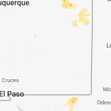
New Mexico
| Local Time | Report Details |
|---|---|
| 8:12 PM MDT | Golf Ball sized hail reported near Hobbs, NM, 76.4 miles SE of Roswell, NM, reported off sh 529 |
| 8:21 PM MDT | Hen Egg sized hail reported near Hobbs, NM, 81.6 miles SE of Roswell, NM, reported off hwy 62 |
Texas
| Local Time | Report Details |
|---|---|
| 11:20 PM CDT | Storm damage reported in parmer county TX, 61.9 miles SW of Amarillo, TX |
| 1:55 AM CDT | Storm damage reported in castro county TX, 51 miles SSW of Amarillo, TX |
| 3:32 AM CDT | Storm damage reported in swisher county TX, 32.2 miles S of Amarillo, TX |
Kansas
| Local Time | Report Details |
|---|---|
| 11:44 PM CDT | Storm damage reported in cheyenne county KS, 38.4 miles NW of Colby, KS |
| 4:45 AM CDT | Very isolated wind damage...roof peeled off building on south side of town and also a few power lines down. time estimated from nearby obs and 911 call. nearby airport in mitchell county KS, 77.2 miles ENE of Hays, KS |
Connect with Interactive Hail Maps